


![]()

ESA Observing the Earth 
zdroje zpráv:
Watch live
4.6.2020 14:20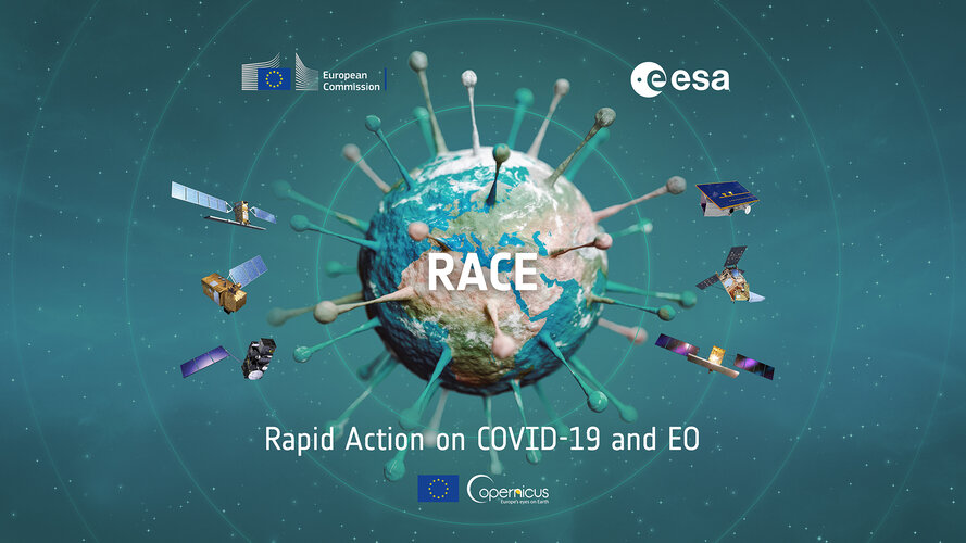
Watch live
Join the event on 5 June at 11:00 CEST, where ESA and the European Commission will present their new dashboard: Rapid action in response to coronavirus with Earth observation
Detecting methane emissions during COVID-19
1.6.2020 14:35
While carbon dioxide is more abundant in the atmosphere and therefore more commonly associated with global warming, methane is around 30 times more potent as a heat-trapping gas. Given its importance, Canadian company GHGSat have worked in collaboration with the Sentinel-5P team at SRON Netherlands Institute for Space Research to investigate hotspots of methane emissions during COVID-19.
Meet the Experts: Ocean views from space
29.5.2020 18:00 Video:
00:06:05
Video:
00:06:05
Earth observation satellites are guardians of our planet. Thanks to remote sensing technology and daily data collection, researchers are able to better monitor our planet's oceans and rising sea levels from space. ESA senior advisor for Earth Observation programmes Jérôme Beneviste explains how ocean views from space play a role in climate change studies and natural catastrophe predictions.
Call for Media: Rapid action in response to coronavirus with Earth observation
29.5.2020 14:00Press Release N° 9–2020
ESA and the European Commission invite media representatives to follow an online event on 5 June at 11:00 CEST where they will present the ‘Rapid Action Coronavirus Earth observation’ dashboard, also known as RACE. The RACE platform provides access to key environmental, economic and social indicators to measure the impact of the coronavirus lockdown and monitor post-lockdown recovery.
Earth from Space: Abu Dhabi
29.5.2020 10:00 Video:
00:02:53
Video:
00:02:53
In this week's edition of the Earth from Space programme, the Copernicus Sentinel-2 mission takes us over part of Abu Dhabi – one of the seven emirates that constitute the United Arab Emirates (UAE).
See also Abu Dhabi to download the image.
Abu Dhabi
29.5.2020 10:00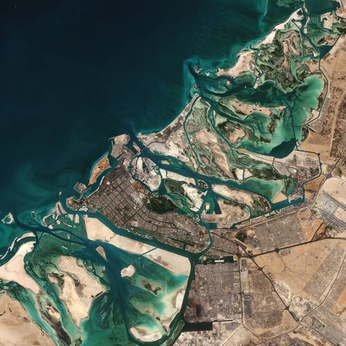 Image:
The Copernicus Sentinel-2 mission takes us over part of Abu Dhabi – one of the seven emirates that constitute the United Arab Emirates (UAE).
Image:
The Copernicus Sentinel-2 mission takes us over part of Abu Dhabi – one of the seven emirates that constitute the United Arab Emirates (UAE).
Ice jam flooding in Fort McMurray
28.5.2020 11:15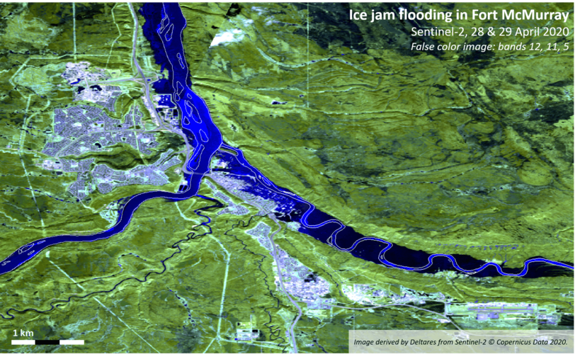 Image:
This false-colour image captured by Copernicus Sentinel-2 shows the extent of an ice jam on the Athabasca River in Canada - leading to the flooding of Fort McMurray.
Image:
This false-colour image captured by Copernicus Sentinel-2 shows the extent of an ice jam on the Athabasca River in Canada - leading to the flooding of Fort McMurray.
Calling for ideas for next Earth Explorer
25.5.2020 12:20
As part of ESA’s continuing commitment to realise cutting-edge satellite missions to advance the scientific understanding of our planet and to show how new technologies can be used in space, a new Call for Earth Explorer mission ideas has been released today.
Earth from Space: Atacama minerals
22.5.2020 10:00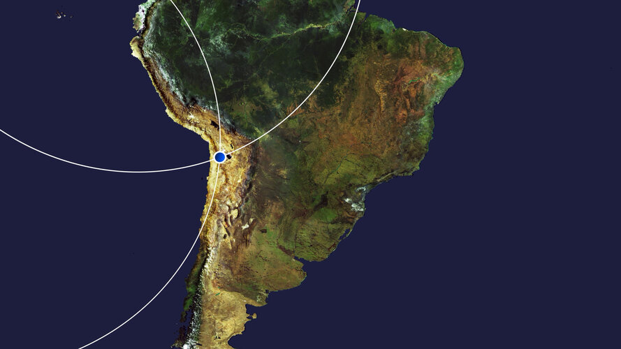 Video:
00:02:46
Video:
00:02:46
In this week's edition of the Earth from Space programme, the Copernicus Sentinel-2 mission takes us over part of Chile's Atacama Desert, considered one of the driest places on Earth.
See also Atacama minerals to download the image.
Snow mass estimates now more reliable
21.5.2020 15:35
Estimating the amount of seasonal snow is important for understanding the water cycle and Earth’s climate system, but establishing a clear and coherent picture of change has proven difficult. New research from ESA’s Climate Change Initiative has helped to produce the first reliable estimate of snow mass change and has helped to identify different continental trends.
Atacama minerals
21.5.2020 10:15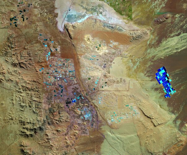 Image:
The Copernicus Sentinel-2 mission takes us over part of Chile's Atacama Desert, one of the driest places on Earth.
Image:
The Copernicus Sentinel-2 mission takes us over part of Chile's Atacama Desert, one of the driest places on Earth.
Swarm probes weakening of Earth’s magnetic field
20.5.2020 13:10
In an area stretching from Africa to South America, Earth’s magnetic field is gradually weakening. This strange behaviour has geophysicists puzzled and is causing technical disturbances in satellites orbiting Earth. Scientists are using data from ESA’s Swarm constellation to improve our understanding of this area known as the ‘South Atlantic Anomaly.’
A sustainable future
19.5.2020 11:00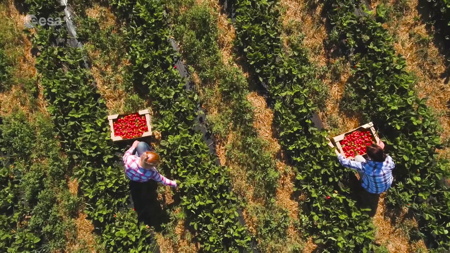 Video:
00:04:00
Video:
00:04:00
With the Covid-19 pandemic halting our daily lives and forcing many countries and region into lockdown, the economic effects have been devastating. Closed borders have caused traffic jams and disrupted supply chains. In Europe, for example, the agriculture industry has suffered. Normally the industry relies on migrant labour to harvest crops, but as the lockdown continues, crops remain unpicked – putting farmers and the food supply under pressure. How can the food supply chain more sustainable?
This video includes an interview with Josef Aschbacher, ESA’s Director of Earth Observation Programmes.
Czech Republic drought visible from space
18.5.2020 9:30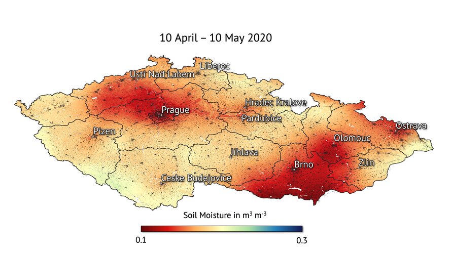
The prolonged period of dry weather in the Czech Republic has resulted in what experts are calling the ‘worst drought in 500 years.’ Scientists are using ESA satellite data to monitor the drought that’s gripped the country.
Czech Republic drought visible from space
18.5.2020 9:30
The prolonged period of dry weather in the Czech Republic has resulted in what experts are calling the ‘worst drought in 500 years.’ Scientists are using ESA satellite data to monitor the drought that’s gripped the country.
Czech Republic drought visible from space
18.5.2020 9:30
The prolonged period of dry weather in the Czech Republic has resulted in what experts are calling the ‘worst drought in 500 years.’ Scientists are using ESA satellite data to monitor the drought that’s gripped the country.
Seen from space: COVID-19 and the environment
15.5.2020 17:12 Video:
00:04:00
Video:
00:04:00
As the COVID-19 pandemic has disrupted lives across the globe, Earth-observing satellites take the pulse of our planet from space. While the global lockdown has had a massive impact on daily life and the economy, there have been environmental benefits that are visible from space. How can we preserve these positives when returning to ‘business as usual’?
This video includes an interview in English with Josef Aschbacher, Director of Earth Observation Programmes.
Earth from Space: San Francisco Bay
15.5.2020 10:00 Video:
00:00:00
Video:
00:00:00
In this week's edition of the Earth from Space programme, the Copernicus Sentinel-2 mission takes us over San Francisco Bay in the US state of California.
See also San Francisco Bay to download the image.
San Francisco Bay
15.5.2020 10:00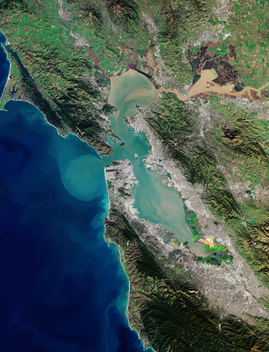 Image:
The Copernicus Sentinel-2 mission takes us over San Francisco Bay in the US state of California.
Image:
The Copernicus Sentinel-2 mission takes us over San Francisco Bay in the US state of California.
Magnetic north and the elongating blob
14.5.2020 16:12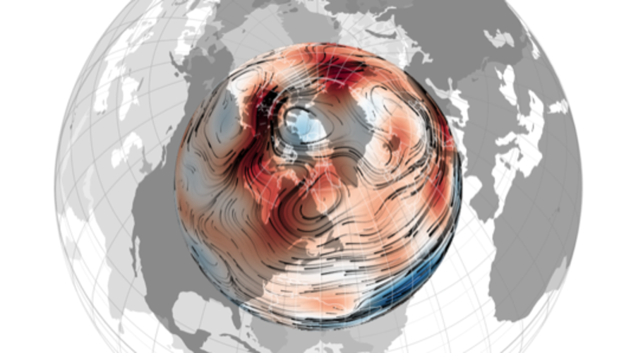
For some years now, scientists have been puzzling over why the north magnetic pole has been making a dash towards Siberia. Thanks, in part, to ESA’s Swarm satellite mission, scientists are now more confident in the theory that tussling magnetic blobs deep below Earth’s surface are at the root of this phenomenon.
Aeolus goes public
12.5.2020 10:00
Delivering new information about Earth’s winds, ESA’s Aeolus mission has already been hailed a success. Today, this remarkable satellite mission has yet again achieved new heights: its data are now being distributed publicly to forecasting services and scientific users in less than three hours of measurements being made from space.
Earth from Space: Northwest Greenland
8.5.2020 10:00 Video:
00:03:33
Video:
00:03:33
This week's edition of the Earth from Space programme features an icy image of Northwest Greenland captured by the Copernicus Sentinel-3 mission.
See also Northwest Greenland to download the image.
Northwest Greenland
8.5.2020 10:00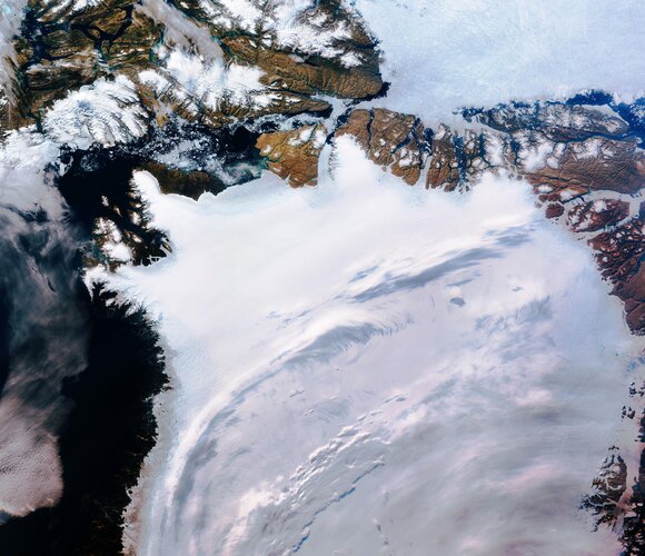 Image:
Northwest Greenland is featured in this icy image captured by the Copernicus Sentinel-3 mission.
Image:
Northwest Greenland is featured in this icy image captured by the Copernicus Sentinel-3 mission.
ESA–EGU award for Earth observation excellence
6.5.2020 17:30
Like all gatherings during these times of COVID-19 isolation, the European Geosciences Union’s annual General Assembly is different this year with thousands of Earth, planetary and space scientists taking part virtually to discuss their research and latest findings. So, with eyes still very much on science this week, ESA’s Director of Earth Observation Programmes, Josef Aschbacher announced the launch of a new award for excellence in Earth observation during his online presentation.
Shedding light on the ocean’s living carbon pump
6.5.2020 12:45
Phytoplankton play a crucial role in ocean biology and climate. Understanding the natural processes that influence phytoplankton primary production, and how they are changing as the planet warms, is vital. A new study, using data from the European Space Agency’s Climate Change Initiative, has produced a 20-year time-series of global primary production in the oceans – shedding new light on the ocean’s living carbon pump.
Building satellites amid COVID-19
4.5.2020 15:40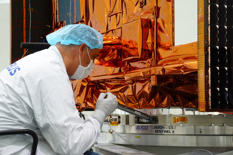
During these unprecedented times of the COVID-19 lockdown, trying to work poses huge challenges for us all. For those that can, remote working is now pretty much the norm, but this is obviously not possible for everybody. One might assume that like many industries, the construction and testing of satellites has been put on hold, but engineers and scientists are finding ways of continuing to prepare Europe’s upcoming satellite missions such as the next Copernicus Sentinels.
Mapping methane emissions on a global scale
4.5.2020 14:00
An important new tool to combat climate change is now available. Using data from the Copernicus Sentinel-5P satellite, this new technology makes it possible to track and attribute methane emissions around the world.
Earth from Space: Southern Ukraine
1.5.2020 10:00 Video:
00:03:01
Video:
00:03:01
In this week's edition of the Earth from Space programme, we explore Southern Ukraine with Copernicus Sentinel-2.
See also Southern Ukraine to download the image.
Southern Ukraine
1.5.2020 10:00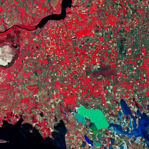 Image:
Southern Ukraine is featured in this false-colour image captured by the Copernicus Sentinel-2 mission.
Image:
Southern Ukraine is featured in this false-colour image captured by the Copernicus Sentinel-2 mission.
Can rain trigger a volcanic eruption?
30.4.2020 8:15
The notion that rain could lead to a volcanic eruption may seem strange, but scientists from the University of Miami in the USA, have used information from satellites, including the Copernicus Sentinel-1 mission, to discover that a period of heavy rainfall may have triggered the four month-long eruption of Hawaii’s Kilauea volcano in 2018.
Namib Desert
24.4.2020 10:00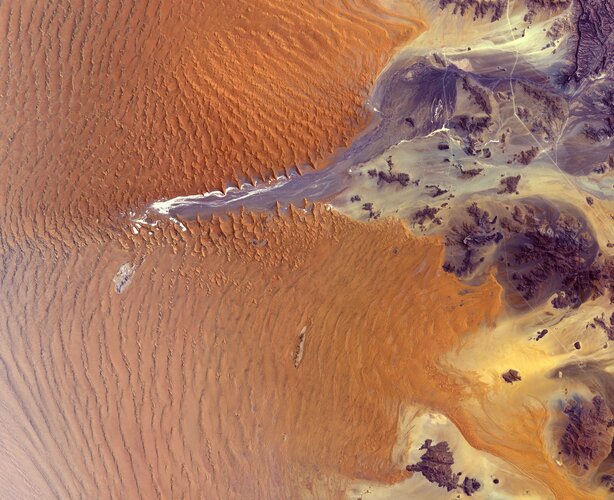 Image:
The Copernicus Sentinel-2 mission takes us over part of the Namib Desert in western Namibia.
Image:
The Copernicus Sentinel-2 mission takes us over part of the Namib Desert in western Namibia.
Earth from Space: Namib Desert
24.4.2020 10:00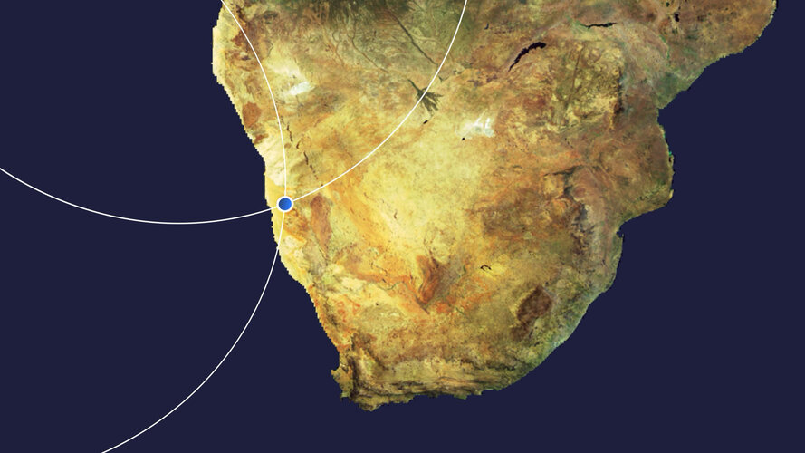 Video:
00:00:00
Video:
00:00:00
In this week's edition of the Earth from Space programme, Copernicus Sentinel-2 takes us over part of the Namib Desert, considered the oldest desert on Earth.
See also Namib Desert to download the image.
Air pollution drops in India following lockdown
24.4.2020 9:18
Lockdowns imposed to halt the spread of the coronavirus have been recently linked with cleaner air quality over Europe and China. New images, from the Copernicus Sentinel-5P satellite, from the European Union Copernicus programme, now show some cities across India seeing levels drop by around 40—50% owing to its nationwide quarantine.
Air pollution drops in India following lockdown
24.4.2020 9:18
Lockdowns imposed to halt the spread of the coronavirus have been recently linked with cleaner air quality over Europe and China. New images, from the Copernicus Sentinel-5P satellite, from the European Union Copernicus programme, now show some cities across India seeing levels drop by around 40–50% owing to its nationwide quarantine.
Dutch tulip fields come into bloom
23.4.2020 13:45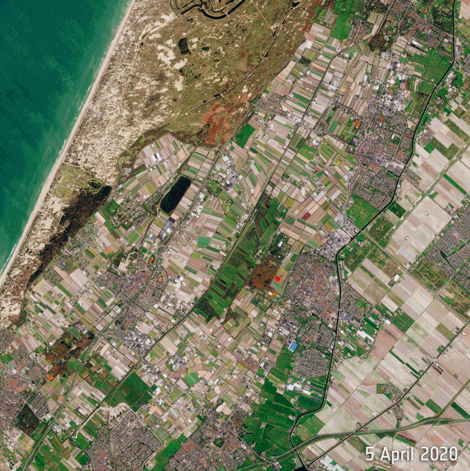 Image:
Captured by the Copernicus Sentinel-2 mission, these beautiful views from space show the Dutch tulip fields coming into bloom.
Image:
Captured by the Copernicus Sentinel-2 mission, these beautiful views from space show the Dutch tulip fields coming into bloom.
Earth Day: taking the pulse of our planet
22.4.2020 9:20
Today marks the 50th anniversary of Earth Day. For Earth-observing satellites, every day is Earth Day. While news of COVID-19 dominates headlines and many of us practice social distancing, there still remains the need for action on climate change – and satellites are vital in providing the key facts on this global issue.
COVID-19: Aeolus and weather forecasts
21.4.2020 16:38
We are all too aware that COVID-19 is a serious threat to health, is putting huge pressure on healthcare systems and it could leave the global economy struggling for years to come. With lockdown measures in force across the globe, the pandemic is also affecting aspects of everyday life that may not be so obvious. The drop in commercial flights, for example, has led to fewer measurements for weather forecasts, but fortunately, ESA’s Aeolus satellite mission is helping to fill the gap.
Ending global plant tracking, Proba-V assigned new focus
20.4.2020 12:18
ESA’s cubic-metre-sized Proba-V minisatellite will soon end its nearly seven-year global mission to monitor the daily growth of all Earth’s vegetation. As Copernicus Sentinel-3 takes on this task instead, Proba-V will be free to perform experimental monitoring over Europe and Africa – including co-observations with new companion missions.
Earth from Space: Montevideo
17.4.2020 10:00 Video:
00:02:39
Video:
00:02:39
In this week's edition of the Earth from Space programme, the Copernicus Sentinel-2 mission takes us over Montevideo – the capital and largest city of Uruguay.
See also Montevideo, Uruguay to download the image.
Montevideo, Uruguay
17.4.2020 10:00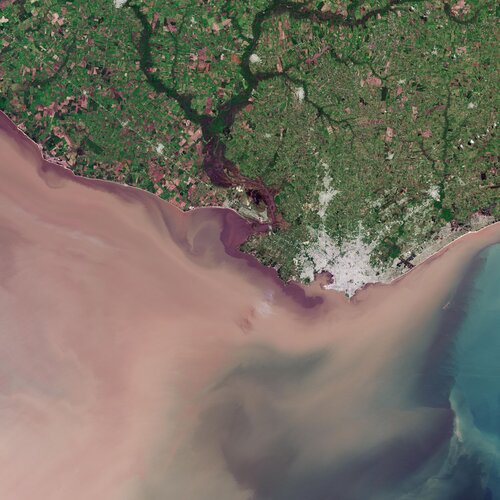 Image:
The Copernicus Sentinel-2 mission takes us over Montevideo – the capital and largest city of Uruguay.
Image:
The Copernicus Sentinel-2 mission takes us over Montevideo – the capital and largest city of Uruguay.
Mapping Chernobyl fires from space
16.4.2020 17:00
With an outbreak of wildfires recently threatening the closed Chernobyl nuclear power plant in the Ukraine, the Copernicus Emergency Mapping Service has been activated and the Copernicus Sentinel-2 satellite mission has imaged the fires and smoke, and mapped the resulting area of burned ground.
Air pollution remains low as Europeans stay at home
16.4.2020 11:00
Further analyses are showing the continued low levels of nitrogen dioxide concentrations across Europe – coinciding with lockdown measures implemented to stop the spread of the coronavirus. New data from the Copernicus Sentinel-5P satellite, from the European Union Copernicus programme, show some cities seeing levels fall by 45—50% compared to the same period last year.
Over 500K downloads for ESA’s SNAP toolbox
16.4.2020 9:54
Reflecting the growing use of Earth observation, a software toolbox that provide users with the tools they need to process satellite data has been downloaded more than 500 000 times in less than five years.
Deserted Venetian lagoon
14.4.2020 17:30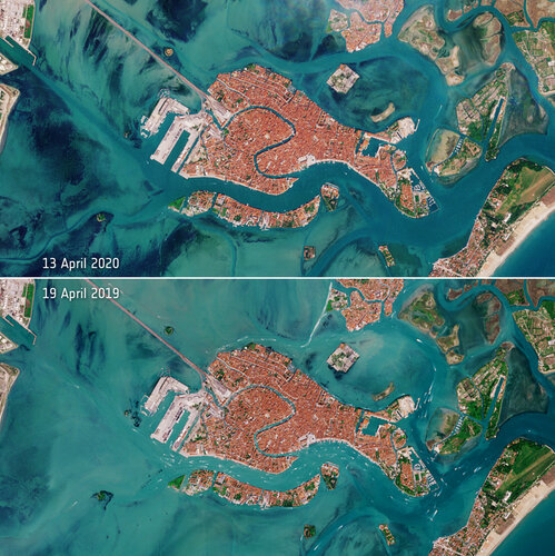 Image:
The Venetian lagoon appears almost deserted following Italy's lockdown to limit the spread of the coronavirus disease - as seen by Copernicus Sentinel-2
Image:
The Venetian lagoon appears almost deserted following Italy's lockdown to limit the spread of the coronavirus disease - as seen by Copernicus Sentinel-2
Satellites providing clear picture of greenhouse gases
14.4.2020 16:10
With increasing levels of greenhouse gases causing our climate to change, it is important to understand exactly where these gases come from and how they disperse in the atmosphere. A new dataset, produced by the European Space Agency’s Climate Change Initiative, provides a detailed view of carbon dioxide and methane – two of the most important human-made gases driving global warming.
Earth from Space: Wheatbelt, Western Australia
10.4.2020 10:00 Video:
00:03:23
Video:
00:03:23
In this week's edition of the Earth from Space programme, Copernicus Sentinel-2 takes us over an area in the Wheatbelt region of Western Australia.
See also Wheatbelt, Western Australia to download the image.
Wheatbelt, Western Australia
10.4.2020 10:00 Image:
This Copernicus Sentinel-2 image features an area in the Wheatbelt region of Western Australia.
Image:
This Copernicus Sentinel-2 image features an area in the Wheatbelt region of Western Australia.
Satellites and machine learning for water management
9.4.2020 17:13
Freshwater is vital to life – but a growing global population, economic development and the effects of climate change are putting mounting pressure on this precious finite resource. Globally, agriculture accounts for 70% of all freshwater consumed, so efficient water management is essential. An ESA project that focuses on fusing data from two different Copernicus Sentinel missions is providing estimates of evapotranspiration, which is not only key for sustainable agriculture, but also important for water resource management and for a number of the United Nations’ Sustainable Development Goals.
CryoSat still cool at 10
8.4.2020 11:00
Today marks 10 years since a Dnepr rocket blasted off from an underground silo in the remote desert steppe of Kazakhstan, launching one of ESA’s most remarkable Earth-observing satellites into orbit. Tucked safely within the rocket fairing, CryoSat had a tough job ahead: to measure variations in the height of Earth’s ice and reveal how climate change is affecting the polar regions. Carrying novel technology, this extraordinary mission has led to a wealth of scientific discoveries that go far beyond its primary objectives to measure polar ice. And, even at 10 years old, this incredible mission continues to surpass expectations.
Unusual ozone hole opens over the Arctic
6.4.2020 9:40
Scientists using data from the Copernicus Sentinel-5P satellite have noticed a strong reduction of ozone concentrations over the Arctic. Unusual atmospheric conditions, including freezing temperatures in the stratosphere, have led ozone levels to plummet – causing a ‘mini-hole’ in the ozone layer.
Finistère, France
3.4.2020 10:00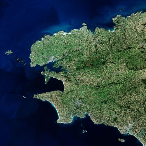 Image:
The Copernicus Sentinel-2 mission takes us over Finistère – a French department in the west of Brittany.
Image:
The Copernicus Sentinel-2 mission takes us over Finistère – a French department in the west of Brittany.
Earth from Space: Finistère
3.4.2020 10:00 Video:
00:00:00
Video:
00:00:00
In this week's edition of the Earth from Space programme, the Copernicus Sentinel-2 mission takes us over Finistère – a French department in the west of Brittany.
See also Finistère, France to download the image.
COVID-19: how can satellites help?
2.4.2020 14:28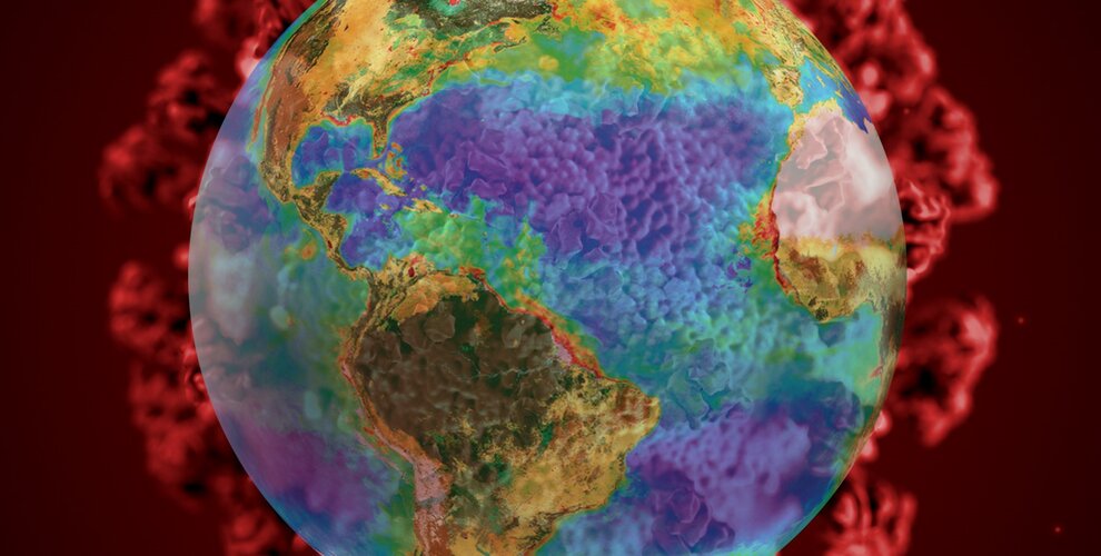
The coronavirus COVID-19 pandemic has virtually paralysed daily life as we know it. Even when the spread of this highly infectious disease has been stemmed, the world will face huge challenges getting back to normal. To help support experts working in Europe’s research centres and technical organisations during these unprecedented times, ESA has issued two new initiatives related to understanding the effects that COVID-19 is imposing on society, the economy and the environment.
Submissions open for Copernicus Masters 2020
1.4.2020 17:00
Awarding innovative solutions, developments and ideas that use Earth observation data to tackle challenges faced by business and society, the Copernicus Masters 2020 competition is now open for submissions.
Coronavirus lockdown leading to drop in pollution across Europe
27.3.2020 11:00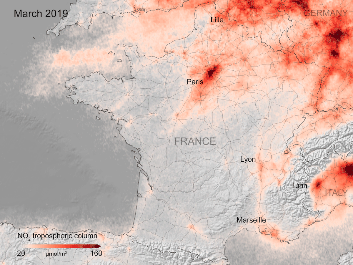
New data, based on observations from the Copernicus Sentinel-5P satellite, are showing strong reductions in nitrogen dioxide concentrations over several major cities across Europe – including Paris, Madrid and Rome.
Earth from Space: Rice fields, Vietnam
27.3.2020 10:00 Video:
00:03:05
Video:
00:03:05
In this week's edition of the Earth from Space programme, the Copernicus Sentinel-1 mission takes us over part of the Mekong Delta – a major rice-producing region in southwest Vietnam.
See also Rice fields, Vietnam to download the image.
Rice fields, Vietnam
27.3.2020 10:00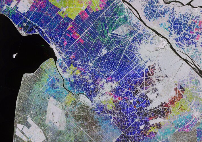 Image:
The Copernicus Sentinel-1 mission takes us over part of the Mekong Delta – a major rice-producing region in southwest Vietnam.
Image:
The Copernicus Sentinel-1 mission takes us over part of the Mekong Delta – a major rice-producing region in southwest Vietnam.
ESA to issue Call for Ideas for next Earth Explorer
23.3.2020 14:34
As part of the ongoing commitment to realise new satellite missions that advance our understanding of Earth, contribute to climate research, benefit society and demonstrate innovative space technologies, ESA soon expects to release a Call for Ideas for Earth Explorer 11, pending approval from Member States at the Programme Board for Earth Observation. The hope is to issue the Call before the end of May, with a deadline to submit full proposals by the end of October 2020.
Land-cover maps of Europe from the Cloud
20.3.2020 11:30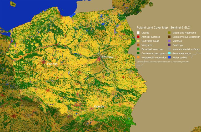
Earth’s land is covered by a range of different types of vegetation, from forest and marsh to crops and bodies of water, as well as the artificial surfaces that are an increasingly common feature of our landscape.
Kuwait
20.3.2020 10:00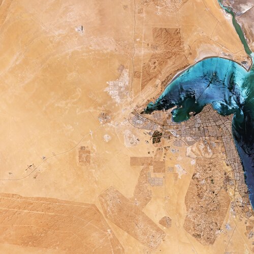 Image:
The Copernicus Sentinel-2 mission takes us over Kuwait in the Middle East.
Image:
The Copernicus Sentinel-2 mission takes us over Kuwait in the Middle East.
Earth from Space: Kuwait
20.3.2020 10:00 Video:
00:03:36
Video:
00:03:36
In this week's edition of the Earth from Space programme, the Copernicus Sentinel-2 mission takes us over Kuwait in the Middle East.
See also Kuwait to download the image.
COVID-19: nitrogen dioxide over China
19.3.2020 16:30
Recent data have shown a decline of air pollution over northern Italy coinciding with its nationwide lockdown to prevent the spread of the coronavirus (COVID-19). This new map shows the variation of nitrogen dioxide concentrations over China from December to March – thanks to the Tropomi instrument on board the Copernicus Sentinel-5P satellite.
COVID-19: nitrogen dioxide over China
19.3.2020 16:30
Recent data have shown a decline of air pollution over northern Italy coinciding with its nationwide lockdown to prevent the spread of the coronavirus (COVID-19). This new map shows the variation of nitrogen dioxide emissions over China from December to March – thanks to the Tropomi instrument on board the Copernicus Sentinel-5P satellite.
Coronavirus: nitrogen dioxide emissions drop over Italy
13.3.2020 16:00 Video:
00:00:00
Video:
00:00:00
New data from the Copernicus Sentinel-5P satellite reveal the decline of air pollution, specifically nitrogen dioxide concentrations, over Italy. This reduction is particularly visible in northern Italy which coincides with its nationwide lockdown to prevent the spread of the coronavirus.
The animation shows the fluctuation of nitrogen dioxide concentrations across Europe from 1 January 2020 until 11 March 2020, using a 10-day moving average. These data are thanks to the Tropomi instrument on board the Copernicus Sentinel-5P satellite which maps a multitude of air pollutants around the globe.
Claus Zehner, ESA’s Copernicus Sentinel-5P mission manager, comments, “The decline in nitrogen dioxide concentrations over the Po Valley in northern Italy is particularly evident.
“Although there could be slight variations in the data due to cloud cover and changing weather, we are very confident that the reduction in concentrations that we can see, coincides with the lockdown in Italy causing less traffic and industrial activities.”
Josef Aschbacher, ESA’s Director of Earth Observation Programmes, says, “Copernicus Sentinel-5P Tropomi is the most accurate instrument today that measures air pollution from space. These measurements, globally available thanks to the free and open data policy, provide crucial information for citizens and decision makers."
The coronavirus disease (COVID-19) was recently declared a pandemic by the World Health Organisation, with more than 125 000 current cases of the disease reported globally. In Italy, the number of coronavirus cases drastically soared making it the country with the largest number of cases outside of China.
In an attempt to reduce the spread of the disease, Italy’s Prime Minister Giuseppe Conte announced a lockdown of the entire country – closing schools, restaurants, bars, museums and other venues across the country.
The Sentinel-5 Precursor – also known as Sentinel-5P – is the first Copernicus mission dedicated to monitoring our atmosphere. The satellite carries the Tropomi instrument to map a multitude of trace gases such as nitrogen dioxide, ozone, formaldehyde, sulphur dioxide, methane, carbon monoxide and aerosols – all of which affect the air we breathe and therefore our health, and our climate.
Given the growing importance and need for the continuous monitoring of air quality, the upcoming Copernicus Sentinel-4 and Sentinel-5 missions, as part of the EU’s Copernicus programme, will monitor key air quality trace gases and aerosols. These missions will provide information on air quality, stratospheric ozone and solar radiation, as well as climate monitoring.
Coronavirus: nitrogen dioxide emissions drop over Italy
13.3.2020 16:00
Video:
00:00:00
New data from the Copernicus Sentinel-5P satellite reveal the decline of air pollution, specifically nitrogen dioxide emissions, over Italy. This reduction is particularly visible in northern Italy which coincides with its nationwide lockdown to prevent the spread of the coronavirus.
The animation shows the fluctuation of nitrogen dioxide emissions across Europe from 1 January 2020 until 11 March 2020, using a 10-day moving average. These data are thanks to the Tropomi instrument on board the Copernicus Sentinel-5P satellite which maps a multitude of air pollutants around the globe.
Claus Zehner, ESA’s Copernicus Sentinel-5P mission manager, comments, “The decline in nitrogen dioxide emissions over the Po Valley in northern Italy is particularly evident.
“Although there could be slight variations in the data due to cloud cover and changing weather, we are very confident that the reduction in emissions that we can see, coincides with the lockdown in Italy causing less traffic and industrial activities.”
Josef Aschbacher, ESA’s Director of Earth Observation Programmes, says, “Copernicus Sentinel-5P Tropomi is the most accurate instrument today that measures air pollution from space. These measurements, globally available thanks to the free and open data policy, provide crucial information for citizens and decision makers."
The coronavirus disease (COVID-19) was recently declared a pandemic by the World Health Organisation, with more than 125 000 current cases of the disease reported globally. In Italy, the number of coronavirus cases drastically soared making it the country with the largest number of cases outside of China.
In an attempt to reduce the spread of the disease, Italy’s Prime Minister Giuseppe Conte announced a lockdown of the entire country – closing schools, restaurants, bars, museums and other venues across the country.
The Sentinel-5 Precursor – also known as Sentinel-5P – is the first Copernicus mission dedicated to monitoring our atmosphere. The satellite carries the Tropomi instrument to map a multitude of trace gases such as nitrogen dioxide, ozone, formaldehyde, sulphur dioxide, methane, carbon monoxide and aerosols – all of which affect the air we breathe and therefore our health, and our climate.
Given the growing importance and need for the continuous monitoring of air quality, the upcoming Copernicus Sentinel-4 and Sentinel-5 missions, as part of the EU’s Copernicus programme, will monitor key air quality trace gases and aerosols. These missions will provide information on air quality, stratospheric ozone and solar radiation, as well as climate monitoring.
 Image:
Victoria Falls
Image:
Victoria Falls
Earth from Space: Victoria Falls
13.3.2020 10:00 Video:
00:02:43
Video:
00:02:43
In this week's edition of the Earth from Space programme, the Copernicus Sentinel-2 mission takes us over Victoria Falls, one of the world’s greatest natural wonders, which lies along the course of the Zambezi River.
See also Victoria Falls to download the image.
In this week's edition of the Earth from Space programme, the Copernicus Sentinel-2 mission takes us over Victoria Falls, one of the world’s greatest natural wonders, which lies along the course of the Zambezi River.
See also Victoria Falls to download the image.
Earth from Space: Victoria Falls
13.3.2020 10:00
Video:
00:02:43
In this week's edition of the Earth from Space programme, the Copernicus Sentinel-2 mission takes us over Victoria Falls, one of the world’s greatest natural wonders, which lies along the course of the Zambezi River.
See also Victoria Falls to download the image.
Greenland and Antarctica losing ice six times faster than expected
11.3.2020 17:00
According to a new report, Greenland and Antarctica are losing ice six times faster than in the 1990s – currently on track with the Intergovernmental Panel on Climate Change’s worst-case climate warming scenario.
Burned area trends in the Amazon similar to previous years
6.3.2020 11:26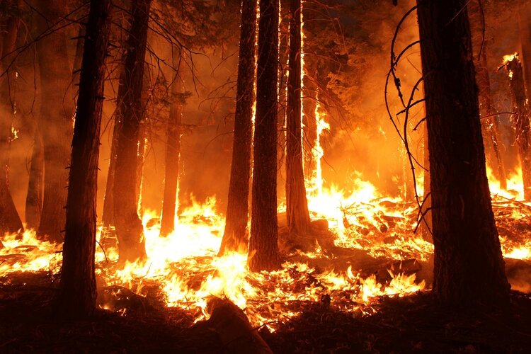
Thousands of fires broke out in the Amazon last year – sparking an international media frenzy. A detailed analysis, using data from the European Space Agency’s Climate Change Initiative, indicates that while there was a small increase of fires in 2019 compared to 2018, fires in Brazil were similar to the average annual number of fires detected over the past 18 years.
Burned area trends in Brazil similar to previous years
6.3.2020 11:26
Thousands of fires broke out in the Amazon last year – sparking an international media frenzy. A detailed analysis, using data from the European Space Agency’s Climate Change Initiative, indicates that while there was a small increase of fires in 2019 compared to 2018, fires in Brazil were similar to the average annual number of fires detected over the past 18 years.
Earth from Space: Canadian Arctic Archipelago
6.3.2020 10:00 Video:
00:03:13
Video:
00:03:13
In this week's edition of the Earth from Space programme, the Copernicus Sentinel-3 mission takes us over part of the Canadian Arctic Archipelago.
See also Canadian Arctic Archipelago to download the image.
In this week's edition of the Earth from Space programme, the Copernicus Sentinel-3 mission takes us over part of the Canadian Arctic Archipelago.
See also Canadian Arctic Archipelago to download the image.
Earth from Space: Canadian Arctic Archipelago
6.3.2020 10:00
Video:
00:03:13
In this week's edition of the Earth from Space programme, the Copernicus Sentinel-3 mission takes us over part of the Canadian Arctic Archipelago.
See also Canadian Arctic Archipelago to download the image.
 Image:
Canadian Arctic Archipelago
Image:
Canadian Arctic Archipelago
 Video:
00:03:13
Video:
00:03:13
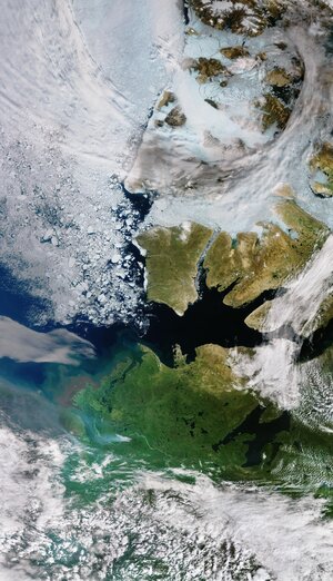 Image:
Canadian Arctic Archipelago
Image:
Canadian Arctic Archipelago
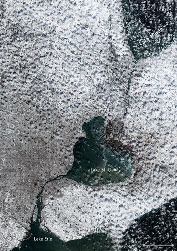 Image:
Let it snow
Image:
Let it snow
 Image:
Let it snow
Image:
Let it snow
Earth from Space: Andros, Bahamas
28.2.2020 10:00 Video:
00:02:58
Video:
00:02:58
In this week's edition of the Earth from Space programme, the Copernicus Sentinel-2 mission takes us over Andros, the largest island of the Bahamas.
See also Andros, Bahamas to download the image.
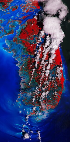 Image:
Andros, Bahamas
Image:
Andros, Bahamas
Earth from Space: Andros, Bahamas
28.2.2020 10:00
Video:
00:02:58
In this week's edition of the Earth from Space programme, the Copernicus Sentinel-2 mission takes us over Andros, the largest island of the Bahamas.
See also Andros, Bahamas to download the image.
In this week's edition of the Earth from Space programme, the Copernicus Sentinel-2 mission takes us over Andros, the largest island of the Bahamas.
See also Andros, Bahamas to download the image.
Picturing permafrost in the Arctic
25.2.2020 16:27
Permafrost plays an important role in the global climate and is also one of the components of the Earth system that is most sensitive to global warming. Maps, produced by ESA’s Climate Change Initiative, are providing new insights into thawing permafrost in the Arctic.
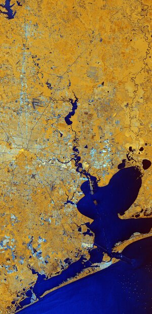 Image:
Houston, Texas
Image:
Houston, Texas
Earth from Space: Houston, Texas
21.2.2020 10:00 Video:
00:02:55
Video:
00:02:55
In this week's edition of the Earth from Space programme, the Copernicus Sentinel-1 mission takes us over Houston, the most populous city in Texas and the fourth largest in the US.
See also Houston, Texas to download the image.
Earth from Space: Houston, Texas
21.2.2020 10:00
Video:
00:02:55
In this week's edition of the Earth from Space programme, the Copernicus Sentinel-1 mission takes us over Houston, the most populous city in Texas and the fourth largest in the US.
See also Houston, Texas to download the image.
In this week's edition of the Earth from Space programme, the Copernicus Sentinel-1 mission takes us over Houston, the most populous city in Texas and the fourth largest in the US.
See also Houston, Texas to download the image.
Bolivian highland heart
14.2.2020 10:00 Image:
For Valentine’s Day, we bring you this Copernicus Sentinel-2 image capturing a beautiful heart-shaped geographical formation in the dramatic landscape of the southern highlands of Bolivia.
The highlands are part of the Altiplano, meaning High Plateau, a region that stretches almost 1000 km from Peru to Bolivia. The landscape consists of a series of basins lying about 3500 m above sea level and is the most extensive area of high plateau on Earth, outside Tibet.
This particular area featured here is a transition between the desert in the west and the tropical forest in the east. The heart-shaped formation has been moulded by many layers of different geological formations over time. The many streams and rivers visible in this image have also contributed to the shaping of the landscape as we see it today.
This false-colour composite image was processed by selecting spectral bands that can be used for classifying geological features – but here the image processing also highlights this lovely heart for today’s image.
Sucre, the capital of the Chuquisaca Department, is visible at the top of the image in grey. Designated a UNESCO World Heritage Site, the city lies at an elevation of around 2800 metres above sea level. To the left of Sucre, the Maragua crater can be seen – a popular hiking destination.
Satellites, such as Copernicus Sentinel-2, allow us to capture beautiful images such as these from space, but also to monitor changing places on Earth. Flying 800 km above, satellites take the pulse of our planet by systematically imaging and measuring changes taking place, which is particularly important in regions that are otherwise difficult to access. This allows for informed decisions to be made to help protect our world for future generations and for all citizens that inhabit our beloved Earth.
We send all our love for Valentine’s Day from the high plateaus of Bolivia – and hope we continue our celebration of love for Earth every day of the year.
This image, which was captured on 26 January 2020, is also featured on the Earth from Space video programme.
Earth from space: Bolivian highland heart
14.2.2020 10:00 Video:
00:00:00
Video:
00:00:00
For Valentine's Day, this week's edition of the Earth from Space programme features a Copernicus Sentinel-2 image, capturing a beautiful heart-shaped geographical formation in the dramatic landscape of the southern highlands of Bolivia.
See also Bolivian highland heart to download the image.
Earth from space: Bolivian highland heart
14.2.2020 10:00
Video:
00:00:00
For Valentine's Day, this week's edition of the Earth from Space programme features a Copernicus Sentinel-2 image, capturing a beautiful heart-shaped geographical formation in the dramatic landscape of the southern highlands of Bolivia.
See also Bolivian highland heart to download the image.
For Valentine's Day, this week's edition of the Earth from Space programme features a Copernicus Sentinel-2 image, capturing a beautiful heart-shaped geographical formation in the dramatic landscape of the southern highlands of Bolivia.
See also Bolivian highland heart to download the image.
Earth from space: Bolivian highland heart
12.2.2020 17:44
Video:
00:00:00
For Valentine's Day, this week's edition of the Earth from Space programme features a Copernicus Sentinel-2 image, capturing a beautiful heart-shaped geographical formation in the dramatic landscape of the southern highlands of Bolivia.
See also Bolivian highland heart to download the image.
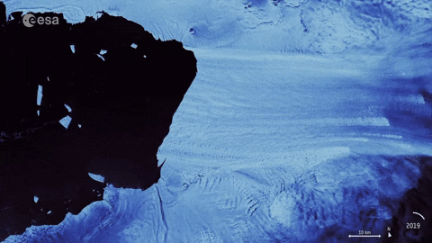
Iceberg shattered
12.2.2020 14:10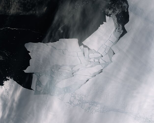 Image:
The Pine Island Glacier recently spawned an iceberg over 300 sq km that very quickly shattered into pieces. This almost cloud-free image, captured on 11 February by the Copernicus Sentinel-2 mission, shows the freshly broken bergs in detail.
A recent animation using 57 radar images captured by the Copernicus Sentinel-1 mission shows just how quickly the emerging cracks from the glacier grew – leading to this historic calving event.
Thanks to the combination of both optical and radar images from the Copernicus Sentinel satellite missions, growing cracks were spotted in the Pine Island Glacier last year, and since then, scientists have been keeping a close eye on how quick the cracks were growing.
The Pine Island Glacier, along with its neighbour Thwaites glacier, connect the centre of the West Antarctic Ice Sheet with the ocean, and together discharge significant quantities of ice into the ocean.
Iceberg shattered
12.2.2020 14:10
Image:
The Pine Island Glacier recently spawned an iceberg over 300 sq km that very quickly shattered into pieces. This almost cloud-free image, captured on 11 February by the Copernicus Sentinel-2 mission, shows the freshly broken bergs in detail.
A recent animation using 57 radar images captured by the Copernicus Sentinel-1 mission shows just how quickly the emerging cracks from the glacier grew – leading to this historic calving event.
Thanks to the combination of both optical and radar images from the Copernicus Sentinel satellite missions, growing cracks were spotted in the Pine Island Glacier last year, and since then, scientists have been keeping a close eye on how quick the cracks were growing.
The Pine Island Glacier, along with its neighbour Thwaites glacier, connect the centre of the West Antarctic Ice Sheet with the ocean, and together discharge significant quantities of ice into the ocean.
Pine Island Glacier spawns piglets
11.2.2020 10:27 Video:
00:00:11
Video:
00:00:11
As anticipated, Pine Island Glacier, known as PIG for short, in Antarctica has just spawned a huge iceberg. At over 300 sq km, about the size of Malta, this huge berg very quickly broke into many ‘piglet’ pieces the largest of which is dubbed B-49. Thanks to images from the Copernicus Sentinel satellite missions, two large rifts in the glacier were spotted last year and scientists have been keeping a close eye on how quickly these cracks were growing. This animation uses 57 radar images captured by the Copernicus Sentinel-1 mission between February 2019 and February 2020 (the last frame is from 10 February 2020) and shows just how quickly the emerging cracks grew and led to this calving event.
Pine Island Glacier, along with its neighbour Thwaites Glacier, connect the centre of the West Antarctic Ice Sheet with the ocean – together discharging significant quantities of ice into the ocean. These two glaciers have been losing ice over the last 25 years. Owing to their extremely remote location, satellites play a critical role in measuring and monitoring Antarctic glaciology – revealing the timing and pace of glacial retreat in Antarctica. Since the early 1990s, the Pine Island Glacier’s ice velocity has increased dramatically to values which exceed 10 m a day. Its floating ice front, which has an average thickness of approximately 500 metres, has experienced a series of calving events over the past 30 years, some of which have abruptly changed the shape and position of the ice front.
These changes have been mapped by ESA-built satellites since the 1990s, with calving events occurring in 1992, 1995, 2001, 2007, 2013, 2015, 2017, 2018, and now 2020.
Mark Drinkwater, senior scientist and cryosphere specialist remarked, “The Copernicus twin Sentinel-1 all-weather satellites have established a porthole through which the public can watch events like this unfold in remote regions around the world. What is unsettling is that the daily data stream reveals the dramatic pace at which climate is redefining the face of Antarctica.”
Get the animated gif here.
The Copernicus Sentinel-2 image can be found here.
Pine Island Glacier spawns piglets
11.2.2020 10:27
Video:
00:00:11
As anticipated, Pine Island Glacier, known as PIG for short, in Antarctica has just spawned a huge iceberg. At over 300 sq km, about the size of Malta, this huge berg very quickly broke into many ‘piglet’ pieces the largest of which is dubbed B-49. Thanks to images from the Copernicus Sentinel satellite missions, two large rifts in the glacier were spotted last year and scientists have been keeping a close eye on how quickly these cracks were growing. This animation uses 57 radar images captured by the Copernicus Sentinel-1 mission between February 2019 and February 2020 (the last frame is from 10 February 2020) and shows just how quickly the emerging cracks grew and led to this calving event.
Pine Island Glacier, along with its neighbour Thwaites Glacier, connect the centre of the West Antarctic Ice Sheet with the ocean – together discharging significant quantities of ice into the ocean. These two glaciers have been losing ice over the last 25 years. Owing to their extremely remote location, satellites play a critical role in measuring and monitoring Antarctic glaciology – revealing the timing and pace of glacial retreat in Antarctica. Since the early 1990s, the Pine Island Glacier’s ice velocity has increased dramatically to values which exceed 10 m a day. Its floating ice front, which has an average thickness of approximately 500 metres, has experienced a series of calving events over the past 30 years, some of which have abruptly changed the shape and position of the ice front.
These changes have been mapped by ESA-built satellites since the 1990s, with calving events occurring in 1992, 1995, 2001, 2007, 2013, 2015, 2017, 2018, and now 2020.
Mark Drinkwater, senior scientist and cryosphere specialist remarked, “The Copernicus twin Sentinel-1 all-weather satellites have established a porthole through which the public can watch events like this unfold in remote regions around the world. What is unsettling is that the daily data stream reveals the dramatic pace at which climate is redefining the face of Antarctica.”
Get the animated gif here.
The Copernicus Sentinel-2 image can be found here.
Pine Island Glacier spawns piglets
11.2.2020 10:27
Video:
00:00:11
As anticipated, Pine Island Glacier, known as PIG for short, in Antarctica has just spawned a huge iceberg. At over 300 sq km, about the size of Malta, this huge berg very quickly broke into many ‘piglet’ pieces the largest of which is dubbed B-49. Thanks to images the Copernicus Sentinel satellite missions, two large rifts in the glacier were spotted last year and scientists have been keeping a close eye on how quickly these cracks were growing. This animation uses 57 radar images captured by the Copernicus Sentinel-1 mission between February 2019 and February 2020 (the last frame is from today, 11 February 2020) and shows just how quickly the emerging cracks grew and led to this calving event.
Pine Island Glacier, along with its neighbour Thwaites Glacier, connect the centre of the West Antarctic Ice Sheet with the ocean – together discharging significant quantities of ice into the ocean. These two glaciers have been losing ice over the last 25 years. Owing to their extremely remote location, satellites play a critical role in measuring and monitoring Antarctic glaciology – revealing the timing and pace of glacial retreat in Antarctica. Since the early 1990s, the Pine Island Glacier’s ice velocity has increased dramatically to values which exceed 10 m a day. Its floating ice front, which has an average thickness of approximately 500 metres, has experienced a series of calving events over the past 30 years, some of which have abruptly changed the shape and position of the ice front.
These changes have been mapped by ESA-built satellites since the 1990s, with calving events occurring in 1992, 1995, 2001, 2007, 2011, 2013, 2015, 2017, 2018, and now 2020.
Mark Drinkwater, senior scientist and cryosphere specialist remarked, “The Copernicus twin Sentinel-1 all-weather satellites have established a porthole through which the public can watch events like this unfold in remote regions around the world. What is unsettling is that the daily data stream reveals the dramatic pace at which climate is redefining the face of Antarctica.”
Pine Island Glacier spawns piglets
11.2.2020 10:27
Video:
00:00:11
As anticipated, Pine Island Glacier, known as PIG for short, in Antarctica has just spawned a huge iceberg. At over 300 sq km, about the size of Malta, this huge berg very quickly broke into many ‘piglet’ pieces the largest of which is dubbed B-49. Thanks to images from the Copernicus Sentinel satellite missions, two large rifts in the glacier were spotted last year and scientists have been keeping a close eye on how quickly these cracks were growing. This animation uses 57 radar images captured by the Copernicus Sentinel-1 mission between February 2019 and February 2020 (the last frame is from today, 11 February 2020) and shows just how quickly the emerging cracks grew and led to this calving event.
Pine Island Glacier, along with its neighbour Thwaites Glacier, connect the centre of the West Antarctic Ice Sheet with the ocean – together discharging significant quantities of ice into the ocean. These two glaciers have been losing ice over the last 25 years. Owing to their extremely remote location, satellites play a critical role in measuring and monitoring Antarctic glaciology – revealing the timing and pace of glacial retreat in Antarctica. Since the early 1990s, the Pine Island Glacier’s ice velocity has increased dramatically to values which exceed 10 m a day. Its floating ice front, which has an average thickness of approximately 500 metres, has experienced a series of calving events over the past 30 years, some of which have abruptly changed the shape and position of the ice front.
These changes have been mapped by ESA-built satellites since the 1990s, with calving events occurring in 1992, 1995, 2001, 2007, 2011, 2013, 2015, 2017, 2018, and now 2020.
Mark Drinkwater, senior scientist and cryosphere specialist remarked, “The Copernicus twin Sentinel-1 all-weather satellites have established a porthole through which the public can watch events like this unfold in remote regions around the world. What is unsettling is that the daily data stream reveals the dramatic pace at which climate is redefining the face of Antarctica.”
Pine Island Glacier spawns piglets
11.2.2020 10:27
Video:
00:00:11
As anticipated, Pine Island Glacier, known as PIG for short, in Antarctica has just spawned a huge iceberg. At over 300 sq km, about the size of Malta, this huge berg very quickly broke into many ‘piglet’ pieces the largest of which is dubbed B-49. Thanks to images from the Copernicus Sentinel satellite missions, two large rifts in the glacier were spotted last year and scientists have been keeping a close eye on how quickly these cracks were growing. This animation uses 57 radar images captured by the Copernicus Sentinel-1 mission between February 2019 and February 2020 (the last frame is from 10 February 2020) and shows just how quickly the emerging cracks grew and led to this calving event.
Pine Island Glacier, along with its neighbour Thwaites Glacier, connect the centre of the West Antarctic Ice Sheet with the ocean – together discharging significant quantities of ice into the ocean. These two glaciers have been losing ice over the last 25 years. Owing to their extremely remote location, satellites play a critical role in measuring and monitoring Antarctic glaciology – revealing the timing and pace of glacial retreat in Antarctica. Since the early 1990s, the Pine Island Glacier’s ice velocity has increased dramatically to values which exceed 10 m a day. Its floating ice front, which has an average thickness of approximately 500 metres, has experienced a series of calving events over the past 30 years, some of which have abruptly changed the shape and position of the ice front.
These changes have been mapped by ESA-built satellites since the 1990s, with calving events occurring in 1992, 1995, 2001, 2007, 2013, 2015, 2017, 2018, and now 2020.
Mark Drinkwater, senior scientist and cryosphere specialist remarked, “The Copernicus twin Sentinel-1 all-weather satellites have established a porthole through which the public can watch events like this unfold in remote regions around the world. What is unsettling is that the daily data stream reveals the dramatic pace at which climate is redefining the face of Antarctica.”
Get the animated gif here.
Flevoland, the Netherlands
7.2.2020 10:00 Image:
The Copernicus Sentinel-1 mission takes us over part of the Dutch province of Flevoland – the newest province in the Netherlands and one of the largest land reclamation projects in the world.
With almost a third of the country lying below sea level, the Netherlands is famously known as a ‘low country,’ and has a long history of land reclamation.
One reclamation project resulted in Flevoland. After a major flood it was decided to tame the Zuiderzee, a large, shallow inlet of the North Sea, to improve flood protection and also create additional land for agricultural use.
The project entailed the creation of land known as polders. The ‘Noordoostpolder,’ or the Northeast polder is the focus of this image. Over the years, the region has developed to become a home to a modern and innovative agricultural industry. The province produces predominantly apples, cereals, potatoes and flowers – with each colourful patch in the image representing a different crop.
This image combines three radar acquisitions from the Copernicus Sentinel-1 mission taken about two months apart to show change in crop and land conditions over time. The first image from 8 May 2018 is associated with red, the second from 7 July depicts changes in green, and the third from 5 September has been linked to blue.
Along the dikes of the Ijsselmeer, west of the Noordoostpolder, lies one of the largest wind farms in the Netherlands. The strong, almost star-shaped, reflections that can be seen near the shore are around 86 wind turbines. The wind farm is said to generate approximately 1.4 billion kWh of clean renewable energy per year – comparable to the power consumption of over 400 000 households.
Images acquired with radar are interpreted by studying the intensity of the backscatter radar signal, which is related to the roughness of the ground. Cities and towns are visible in white owing to the stronger reflection of the signal. Emmeloord can be seen in the centre of the Noordoostpolder, as well as several farms that appear as bright white dots along the roads.
This image is also featured on the Earth from Space video programme.
Flevoland, the Netherlands
7.2.2020 10:00
Image:
The Copernicus Sentinel-1 mission takes us over part of the Dutch province of Flevoland – the newest province in the Netherlands and one of the largest land reclamation projects in the world.
With almost a third of the country lying below sea level, the Netherlands is famously known as a ‘low country,’ and has a long history of land reclamation.
One reclamation project resulted in Flevoland. After a major flood it was decided to tame the Zuiderzee, a large, shallow inlet of the North Sea, to improve flood protection and also create additional land for agricultural use.
The project entailed the creation of land known as polders. The ‘Noordoostpolder,’ or the Northeast polder is the focus of this image. Over the years, the region has developed to become a home to a modern and innovative agricultural industry. The province produces predominantly apples, cereals, potatoes and flowers – with each colourful patch in the image representing a different crop.
This image combines three radar acquisitions from the Copernicus Sentinel-1 mission taken about two months apart to show change in crop and land conditions over time. The first image from 8 May 2018 is associated with blue, the second from 7 July depicts changes in green, and the third from 5 September has been linked to red.
Along the dikes of the Ijsselmeer, west of the Noordoostpolder, lies one of the largest wind farms in the Netherlands. The strong, almost star-shaped, reflections that can be seen near the shore are around 86 wind turbines. The wind farm is said to generate approximately 1.4 billion kWh of clean renewable energy per year – comparable to the power consumption of over 400 000 households.
Images acquired with radar are interpreted by studying the intensity of the backscatter radar signal, which is related to the roughness of the ground. Cities and towns are visible in white owing to the stronger reflection of the signal. Emmeloord can be seen in the centre of the Noordoostpolder, as well as several farms that appear as bright white dots along the roads.
This image is also featured on the Earth from Space video programme.
Earth from Space: Flevoland
7.2.2020 10:00 Video:
00:03:01
Video:
00:03:01
In this week's edition of the Earth from Space programme, the Copernicus Sentinel-1 mission takes us over part of the Dutch province of Flevoland – the newest province in the Netherlands and one of the largest land reclamation projects in the world.
See also Flevoland, the Netherlands to download the image.
Earth from Space: Flevoland
7.2.2020 10:00
Video:
00:03:01
In this week's edition of the Earth from Space programme, the Copernicus Sentinel-1 mission takes us over part of the Dutch province of Flevoland – the newest province in the Netherlands and one of the largest land reclamation projects in the world.
See also Flevoland, the Netherlands to download the image.
Space key to wetland conservation
5.2.2020 9:00
Wetlands worldwide are vanishing at an alarming rate. New maps produced by ESA’s GlobWetland Africa project show how satellite observations can be used for the effective use and management of wetlands in Africa.
Earth from Space: Lake George
31.1.2020 10:00 Video:
00:03:07
Video:
00:03:07
Ahead of World Wetlands Day, celebrated internationally each year on 2 February, this week's edition of the Earth from Space programme features a Copernicus Sentinel-2 image over Lake George in western Uganda. In 1988, Lake George was designated as Uganda’s first site under the Ramsar Convention - an international treaty for the conservation and sustainable use of wetlands.
See also Lake George, Uganda to download the image.
Lake George, Uganda
31.1.2020 10:00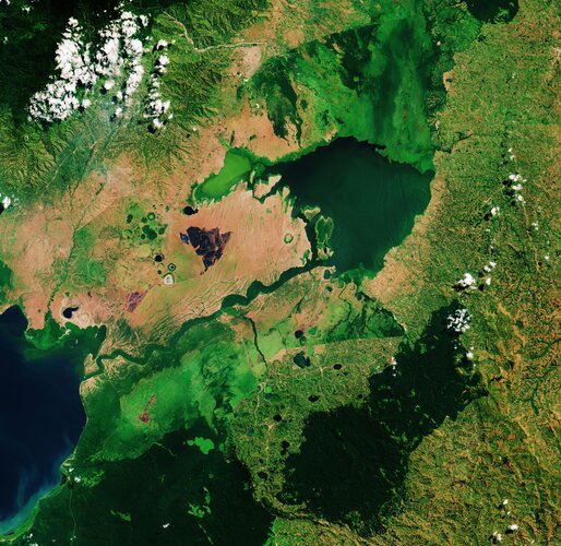 Image:
World Wetlands Day is celebrated internationally each year on 2 February. It marks the anniversary of the signing of the Convention on Wetlands of International Importance, known as the Ramsar Convention, in Ramsar, Iran, on 2 February 1971.
World Wetlands Day raises global awareness about the vital role of wetlands for our planet, paying particular attention to wetland biodiversity.
This Copernicus Sentinel-2 image takes us over Lake George, in western Uganda. In 1988, Lake George was designated as Uganda’s first Ramsar site, given its importance as a centre for biological diversity.
This equatorial lake covers an area of around 250 sq km and has an average depth of around 2.4 metres. Lake George is fed by a complex system of rivers and streams originating from the Rwenzori mountains – supplying a system of permanent swamps surrounding the lake.
A dense fringe of wetland grass, visible in bright green, can be seen around the edges of the lake in the centre of the image.
The wetlands provide a natural living space for a number of mammals including elephants, hippopotamus and antelope. They also provide a habitat for over 150 species of birds including several rare species such as the saddle-billed stork.
Seen from above, the waters of Lake George appear green as a result of the thick concentration of blue-green algae. Metal pollution, mine seepage and agricultural runoff has caused serious pollution to the lake’s waters and are severely impacting the lake’s health.
Lake George drains through the Kazinga Channel in the image’s centre. The wide, 32km long channel connects Lake George with Lake Edward, which lies on the border between Uganda and the Democratic Republic of the Congo.
The Kazinga Channel flows through the Queen Elizabeth National Park. The almost 2000 sq km park is known for its wildlife including the African buffalo and the Nile crocodile.
The park is also famous for its volcanic features, including volcanic cones and deep craters which can be seen dotted around the image. Many contain crater lakes, including the Katwe crater lake, whose salt deposits have been mined for centuries.
Sentinel-2 is a two-satellite mission to supply the coverage and data delivery needed for Europe’s Copernicus programme. The mission’s frequent revisits over the same area and high spatial resolution allow changes in inland water bodies to be closely monitored.
This image is also featured on the Earth from Space video programme.
Earth from Space: Lake George
31.1.2020 10:00
Video:
00:03:07
Ahead of World Wetlands Day, celebrated internationally each year on 2 February, this week's edition of the Earth from Space programme features a Copernicus Sentinel-2 image over Lake George in western Uganda. In 1988, Lake George was designated as Uganda’s first site under the Ramsar Convention - an international treaty for the conservation and sustainable use of wetlands.
See also Lake George, Uganda to download the image.
Sentinel-6 satellite renamed in honour of renowned US scientist
28.1.2020 15:20
ESA, NASA, the European Commission, the European Organisation for the Exploitation of Meteorological Satellites (EUMETSAT) and the National Oceanic and Atmospheric Administration (NOAA) have renamed the upcoming Sentinel-6A satellite after Earth scientist Dr. Michael H. Freilich.
Sentinel-6 satellite renamed in honour of renowned US scientist
28.1.2020 15:20
ESA, NASA, the European Commission, the European Organisation for the Exploitation of Meteorological Satellites (EUMETSAT) and the National Oceanic and Atmospheric Administration (NOAA) have renamed the upcoming Sentinel-6A satellite after Earth scientist Dr Michael H. Freilich.