


![]()


ESA Navigation 
zdroje zpráv:
 Image:
Satnav from Earth to the Moon
Image:
Satnav from Earth to the Moon
European Navigation Conference at ESTEC discusses more resilient satnav
8.6.2023 14:35
This year’s European Navigation Conference took place from 31 May to 2 June at ESA’s ESTEC technical centre in Noordwijk, home to the Agency’s navigation efforts. The ENC is organised each year under the umbrella the European Group of Institutes of Navigation (EUGIN) and this year by the Netherlands Institute of Navigation (NIN). Top of the list of discussions points? Enhancing the resilience of the positioning, navigation, and timing (PNT) systems all of us have come to depend on.
European Navigation Conference at ESTEC discusses more resilient satnav
8.6.2023 14:35
This year’s European Navigation Conference took place from 31 May to 2 June at ESA’s ESTEC technical centre in Noordwijk, home to the Agency’s navigation efforts. The ENC is organised each year under the umbrella the European Group of Institutes of Navigation (EUGIN) and this year by the Netherlands Institute of Navigation (NIN). Top of the list of discussion points? Enhancing the resilience of the positioning, navigation, and timing (PNT) systems all of us have come to depend on.
Galileo Second Generation enters full development phase
1.6.2023 9:35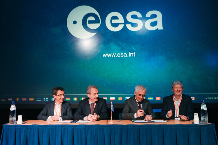
The main procurements batch of Galileo Second Generation initiated last summer has been finalised, leaving the system ready for its In Orbit Validation development phase. Today, following the opening session of the European Navigation Conference (ENC), ESA Director of Navigation Javier Benedicto invited Thales (Italy), Airbus Defence and Space (Germany) and Thales Six GTS (France) to sign the respective contracts commencing System Engineering Support for the next generation of Europe’s navigation satellite system.
Galileo Second Generation enters full development phase
1.6.2023 9:35
Update July 2023:
Three more contracts for Galileo’s Second Generation development have been signed by ESA, on behalf of EUSPA, with respectively GMV (Spain) for the Ground Control Segment, Thales (France) for Security Monitoring and Thales Alenia Space (France) on the Ground Mission Segment. In total, an amount of approximately €900 million has been awarded since summer 2022 which will lead forward the development of Galileo’s Second Generation to provide more robust, resilient, and new services in the near future for users worldwide.
Galileo Second Generation enters full development phase
31.5.2023 14:35
The main procurements batch of Galileo Second Generation initiated last summer has been finalised, leaving the system ready for its In Orbit Validation development phase. Today, following the opening session of the European Navigation Conference (ENC), ESA Director of Navigation Javier Benedicto invited Thales Alenia Space (Italy), Airbus Defence and Space (Germany) and Thales Six GTS (France) to sign the respective contracts commencing System Engineering Support for the next generation of Europe’s navigation satellite system.
GENESIS of a new Earth: join ESA’s Earth measurement mission
31.3.2023 13:41
The idea behind ESA’s GENESIS mission is simple: a fixed framework is needed to chart the relative positions of locations across our planet, and satellites in orbit serve as the foundation of this framework. Fix a satellite’s own position in space accurately enough and you can measure Earth under it much more precisely too.
GENESIS of a new Earth: join ESA’s Earth measurement mission
31.3.2023 13:41
The idea behind ESA’s GENESIS mission is simple: a fixed framework is needed to chart the relative positions of locations across our planet, and satellites in orbit serve as the foundation of this framework. Fix a satellite’s own position in space accurately enough and you can measure Earth beneath it much more precisely too.
First ever ESA Academy Navigation Training Course!
24.3.2023 16:13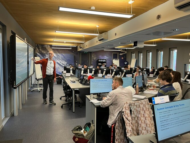
For the first time ever, ESA Academy is opening a call for university students to apply for the pilot edition of the Navigation Training Course, to be held from 26 to 30 June 2023 at ESA Academy’s Training and Learning Facility in ESEC-Galaxia, Belgium. This Training Course has been developed by ESA Education and ESA’s Directorate of Navigation. Would you like to know more about the future of satellite navigation? Apply for our course today!
Galileo: no way without time
10.3.2023 14:55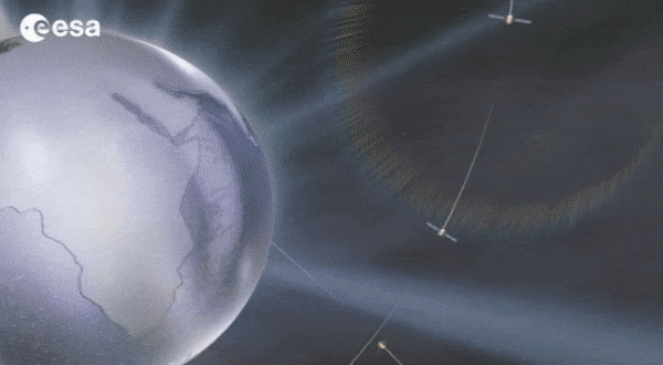
Europe’s Galileo is the world’s most precise satellite navigation system, providing metre-level accuracy and very precise timing to its four billion users. An essential ingredient to ensure this stays the case are the atomic clocks aboard each satellite, delivering pinpoint timekeeping that is maintained to a few billionths of a second. These clocks are called atomic because their ‘ticks’ come from ultra-rapid, ultra-stable oscillation of atoms between different energy states. Sustaining this performance demands, in turn, even more accurate clocks down on the ground to keep the satellites synchronised and ensure stability of time and positioning for users.
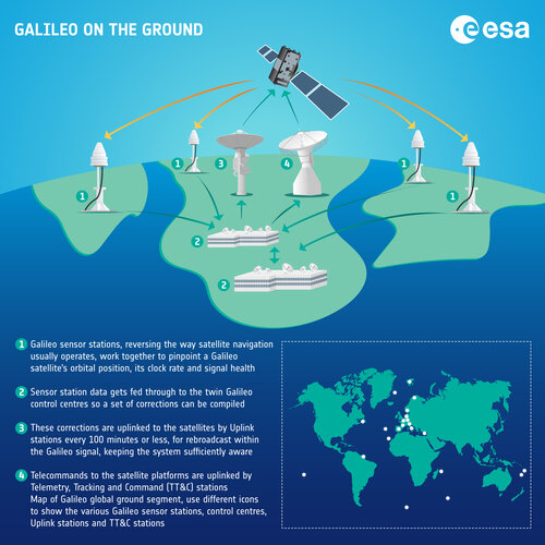 Image:
Galileo on the ground – infographic
Image:
Galileo on the ground – infographic
 Image:
Galileo on the ground – infographic
Image:
Galileo on the ground – infographic
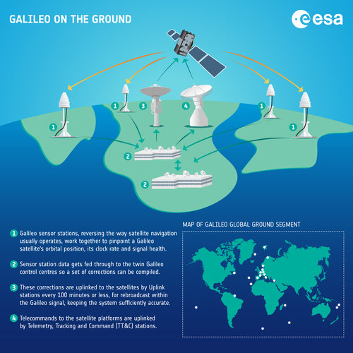 Image:
Galileo on the ground – infographic
Image:
Galileo on the ground – infographic
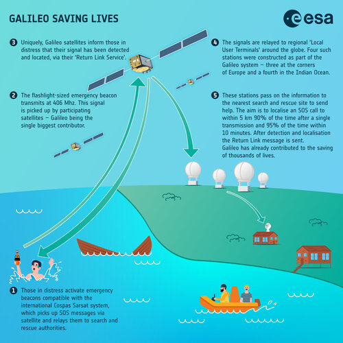 Image:
Galileo saving lives – infographic
Image:
Galileo saving lives – infographic
How does Galileo help other space missions?
9.3.2023 12:30
In 2023 satnav receivers are everywhere: in our phones, our cars, and drones, in fixed infrastructure, aboard boats, trains and aircraft. They are also in space: more than 95% of all the satellites in low-Earth orbit carry satnav receivers to calculate their position. The additional signals from Europe’s Galileo satellites are providing a big boost to the coverage, availability, redundancy, and accuracy of spaceborne receivers, in turn enlarging the possible scope of future missions, and extending the useful range of satnav much further out into space – to the Moon and beyond.
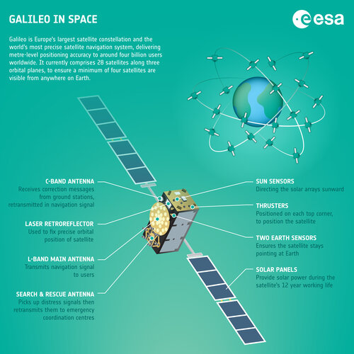 Image:
Galileo in space – infographic
Image:
Galileo in space – infographic
Navigation Lab exploring Galileo’s future – and beyond
8.3.2023 13:00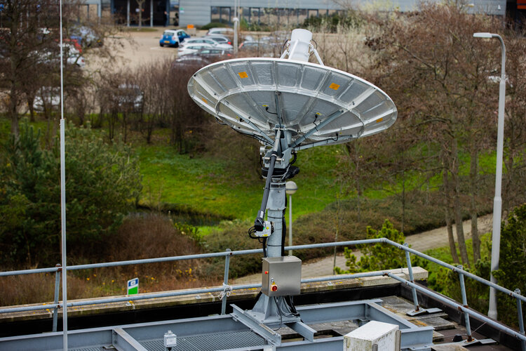
Would you like to know the future of satellite navigation? Try ESA’s Navigation Laboratory. This is a site where navigation engineers test prototypes of tomorrow's user receivers, using simulated versions of the navigation signals planned for the coming decade, such as set to be transmitted from Galileo’s Second Generation satellites.
Galileo, how you’ve grown!
7.3.2023 10:59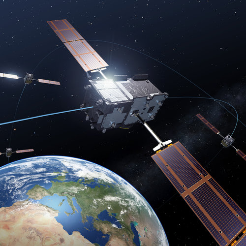
Today Galileo is the world’s most precise satellite navigation system, delivering metre-level accuracy, and if you are a modern smartphone owner then you – like nearly four billion others around the world – are among its users. This week we are celebrating that almost exactly a decade ago, on 12 March 2013, Europe for the first time ever was able to determine a position on the ground using only its own independent navigation system, Galileo.
Galileo, how you’ve grown
7.3.2023 10:59
Today Galileo is the world’s most precise satellite navigation system, delivering metre-level accuracy, and if you are a modern smartphone owner then you – like nearly four billion others around the world – are among its users. This week we are celebrating that almost exactly a decade ago, on 12 March 2013, Europe for the first time ever was able to determine a position on the ground using only its own independent navigation system, Galileo.
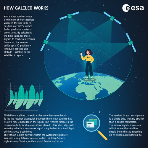 Image:
How Galileo works - infographic
Image:
How Galileo works - infographic
Telling time on the Moon
27.2.2023 14:30
A new era of lunar exploration is on the rise, with dozens of Moon missions planned for the coming decade. Europe is in the forefront here, contributing to building the Gateway lunar station and the Orion spacecraft – set to return humans to our natural satellite – as well as developing its large logistic lunar lander, known as Argonaut. As dozens of missions will be operating on and around the Moon and needing to communicate together and fix their positions independently from Earth, this new era will require its own time.
ESA invites you to satnav summer school in Sweden
24.2.2023 13:17
This year’s ESA/JRC International Summer School on Global Navigation Satellite Systems (GNSS) will take place in July in Kiruna, Sweden.
Galileo signal component tested for Internet of Things use
9.2.2023 12:45
One of Europe's Galileo satellites has been reconfigured to emit a new signal component optimised to serve low-end receiver devices and Internet of Things applications.
Industry Day: find out how to take part in low-orbit satnav testing
7.2.2023 12:01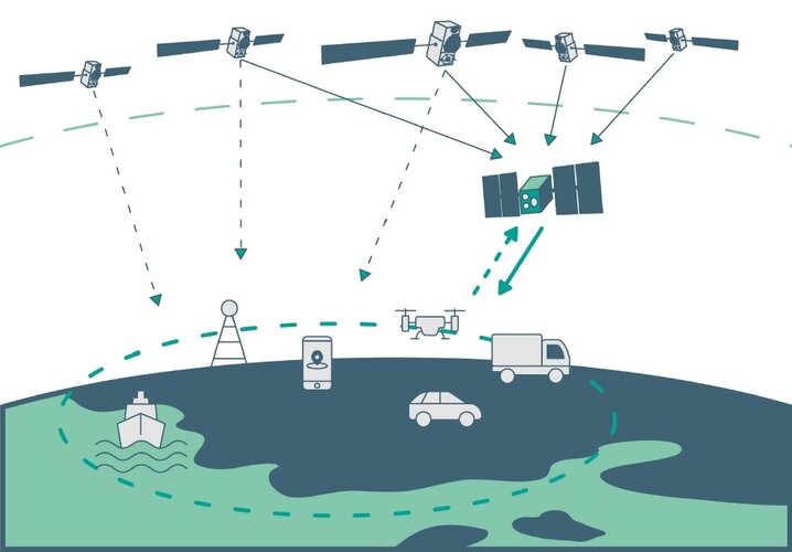
ESA is embarking on the in-orbit demonstration of a new satellite navigation constellation operating much closer to our planet, utilising novel frequencies and capabilities, so the Agency is looking for European companies interested in taking part. Attend ESA’s LEO-PNT Industry Day on 7 March at ESA’s ESTEC technical centre in the Netherlands to find out more.
New Galileo service set to deliver 20 cm accuracy
24.1.2023 15:41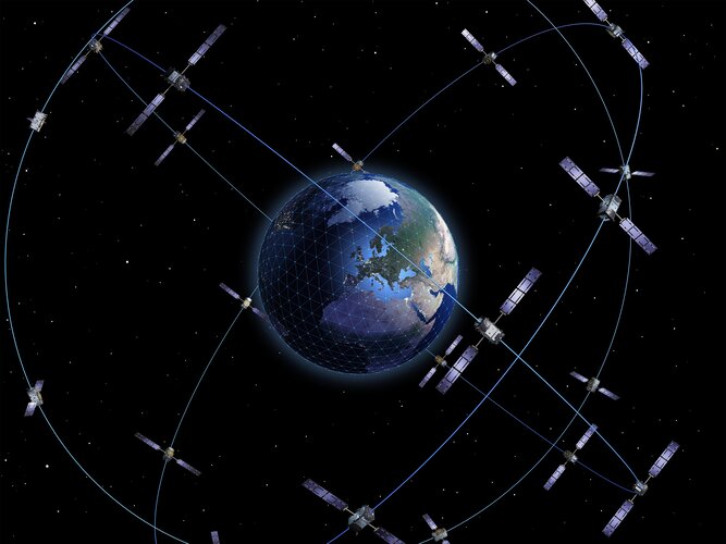
Galileo’s capabilities have grown with the addition of a new High Accuracy Service, freely available worldwide to anyone with a suitably equipped receiver. Delivering horizontal accuracy down to 20 cm and vertical accuracy of 40 cm, the High Accuracy Service is enabled through an additional level of real-time positioning corrections, delivered through a new data stream within the existing Galileo signal.
ESA to invite companies to connect with the Moon
21.12.2022 9:47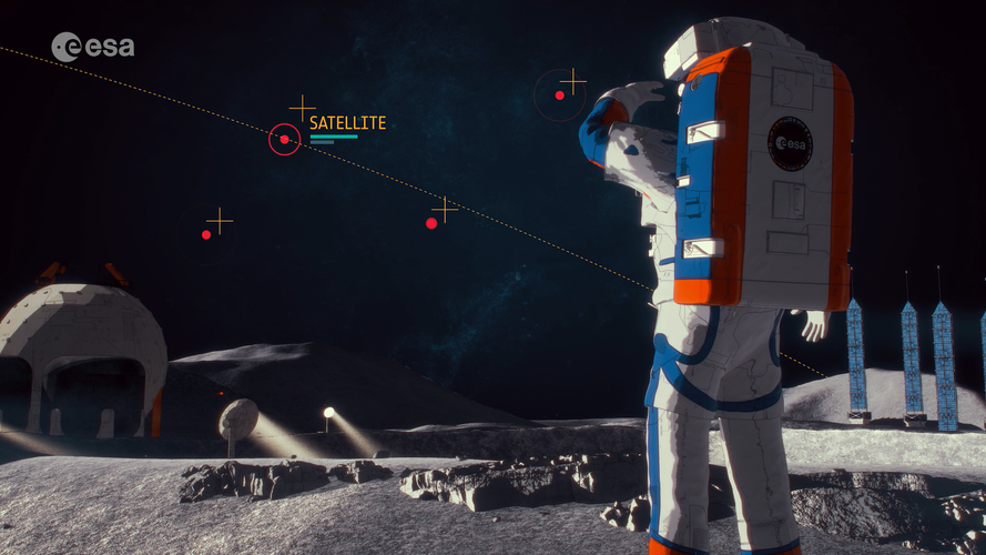
Space companies in Europe that could create telecommunications and navigation services for missions to the Moon will be invited to bid for the work, following the completion of two feasibility studies.
Even safer satnav for aircraft: upgraded EGNOS on the way
16.12.2022 11:06
Making satellite navigation sufficiently accurate by improving its integrity for aircraft to rely on, the European Geostationary Navigation Overlay System, EGNOS, is today employed by hundreds of airports across our continent, guiding airliners down through all weathers to the point where pilots gain sight of runways to initiate landing. Now an upgraded version of the system, EGNOS v3, has passed its Critical Design Review – putting it on track to enter service by the second part of the decade.
ESA Navigation portfolio expanded and diversified by Ministerial Council
25.11.2022 14:04
ESA’s Directorate of Navigation was pledged a total of €351 million by the Agency’s Member States during this week’s ESA Council at Ministerial Level on November 22 and 23. With this funding boost ESA sees its leading role in satellite navigation strengthened with a new programme FutureNAV, the continuation of its innovation programme NAVISP, and the kick-off of the Moonlight initiative for lunar telecommunications and navigation coverage.
Navigating the sea from space with innovative technologies
18.11.2022 11:45
Shipping is the most energy efficient form of transport, and more than 80% of goods traded globally are carried via the oceans, with a doubling in volume during the last quarter of a century. Recognising the global need for seamless maritime navigation, ESA’s Navigation Innovation and Support Programme, NAVISP – inventing the future of navigation with more than 200 R&D projects initiated to date – is therefore focused not only on the land but also the sea.
Saying goodbye to Galileo 1st Generation
14.11.2022 15:00 Video:
00:04:05
Video:
00:04:05
Galileo is Europe’s largest satellite constellation – and the world’s most accurate satnav system. The work on Galileo began two decades ago with two test GIOVE satellites, followed by a series of operational launches.
The two GIOVE satellites, the first Galileo In-Orbit Validation satellite and all 34 Galileo Full Operational Capability satellites were tested at ESA’s ESTEC Test Centre, Europe’s largest satellite testing facility.
On this day the very last satellite in the Galileo First Generation series leaves the site, and the people responsible for readying them for space have gathered to say goodbye. Next will come the Galileo Second Generation satellites, already in development.
About Galileo
Galileo is managed and funded by the European Union. The European Commission, ESA and EUSPA (the EU Agency for the Space Programme) have signed an agreement by which ESA acts as design authority and system development prime on behalf of the Commission and EUSPA as the exploitation and operation manager of Galileo/EGNOS.
NASA laser reflector for ESA satnav on Lunar Pathfinder
10.11.2022 14:32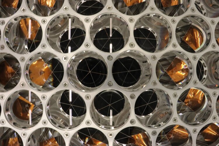
NASA has delivered a retroreflector array to ESA that will allow the Lunar Pathfinder mission to be pinpointed by laser ranging stations back on Earth as it orbits the Moon. Such centimetre level laser measurements will serve as an independent check on the spacecraft as it fixes its position using Galleo and GPS signals from an unprecedented 400 000 km away from Earth – proving the concept of lunar satnav while also relaying telecommunications ahead of ESA’s dedicated Moonlight initiative.
What is ESA’s Moonlight initiative?
9.11.2022 16:00
Video:
00:03:21
Going to the Moon was the first step. Staying there is the next ambition.
ESA is a key partner in NASA’s Artemis programme, which aims to return people to the Moon by the end of decade. Dozens of other international public and private missions are setting their sights on the lunar surface in the coming years.
But to achieve a permanent and sustainable presence on the Moon, reliable and autonomous lunar communications and navigation services are required.
This is why ESA is working with its industrial partners on the Moonlight initiative, to become the first off-planet commercial telecoms and satellite navigation provider.
Following their launch, three or four satellites will be carried into lunar orbit by a space tug and deployed one by one, to form a constellation of lunar satellites. The number and specification of these satellites are currently being defined.
The constellation's orbits are optimised to give coverage to the lunar south pole, whose sustained sunlight and polar ice make it the focus of upcoming missions.
Moonlight will provide data capacities sufficient to serve these planned and future missions, with a navigation service that enables accurate real-time positioning for all lunar missions.
What is ESA’s Moonlight initiative?
9.11.2022 16:00
Video:
00:03:21
Going to the Moon was the first step. Staying there is the next ambition.
ESA is a key partner in NASA’s Artemis programme, which aims to return people to the Moon by the end of the decade. Dozens of other international public and private missions are setting their sights on the lunar surface in the coming years.
But to achieve a permanent and sustainable presence on the Moon, reliable and autonomous lunar communications and navigation services are required.
This is why ESA is working with its industrial partners on the Moonlight initiative, to become the first off-planet commercial telecoms and satellite navigation provider.
Following their launch, three or four satellites will be carried into lunar orbit by a space tug and deployed one by one, to form a constellation of lunar satellites. The number and specification of these satellites are currently being defined.
The constellation's orbits are optimised to give coverage to the lunar south pole, whose sustained sunlight and polar ice make it the focus of upcoming missions.
Moonlight will provide data capacities sufficient to serve these planned and future missions, with a navigation service that enables accurate real-time positioning for all lunar missions.
Testing Galileo for space
3.11.2022 15:00 Video:
00:06:36
Video:
00:06:36
Galileo has grown to become Europe’s single largest satellite constellation, and the world’s most accurate satellite navigation system, delivering metre-level positioning to more than 3.5 billion users around the globe.
It all began at ESTEC’s Test Centre, Europe’s largest satellite testing facility. This is where the very first positioning fix took place in March 2013, after the launch into orbit of the initial four IOV satellites. Following that, all 34 Galileo Full Operational Capability satellites also passed by ESTEC for their pre-flight testing.
This 3000 sq. m environmentally-controlled complex, operated and managed by European Test Services for ESA, hosts an array of test equipment able to simulate all aspects of spaceflight, from the noise and vibration of launch to the vacuum and temperature extremes of Earth orbit.
The production line at manufacturer OHB in Germany completed one new satellite every six weeks. After integration each satellite was then shipped to the ESTEC Test Centre for a three-month test campaign, after which it would be accepted by the Agency and declared ready for flight. Some facilities have had to be adapted specifically for Galileo, and the ESTEC Test Centre had to institute new security protocols because this was the first time that satellites with security restrictions were being tested at the site.
Today there are 28 of these Galileo First Generation satellites in service, with 10 more due to be launched in the next years. Upgraded Galileo Second Generation satellites are under development and will follow them into orbit later this decade.
Members of ESA’s Galileo team and ETS look back on this massive testing effort that established Galileo was ready for space.
About Galileo
Galileo is managed and funded by the European Union. The European Commission, ESA and EUSPA (the EU Agency for the Space Programme) have signed an agreement by which ESA acts as design authority and system development prime on behalf of the Commission and EUSPA as the exploitation and operation manager of Galileo/EGNOS.
ESA plans for low-orbiting navigation satellites
26.10.2022 13:21
Satellite navigation is headed closer to users. ESA’s Navigation Directorate is planning an in-orbit demonstration with new navigation satellites that will orbit just a few hundred kilometres up in space, supplementing Europe’s 23 222-km-distant Galileo satellites. Operating added-value signals, these novel so-called ‘LEO-PNT’ satellites will investigate a new multi-layer satnav system-of-systems approach to deliver seamless Positioning, Navigation and Timing services that are much more accurate, robust and available everywhere.
Mapping planet Earth for better positioning: ESA’s GENESIS mission
20.10.2022 12:43
ESA’s Navigation Directorate is planning a new satellite whose results will enable the generation of an updated global model of Earth – the International Terrestrial Reference Frame, employed for everything from land surveying to measuring sea level rise – with an accuracy down to 1 mm, while tracking ground motion of just 0.1 mm per year. This improvement, at a stroke, will have a major impact in multiple navigation and Earth science applications, including enhancing the precision of the Galileo navigation system. This mission, called GENESIS, is being proposed to ESA’s Council Meeting at Ministerial Level next month.
Navigation at Ministerial Council 2022
12.10.2022 10:56
The ESA Council at Ministerial level, CM22, is a time for critical decisions. In November 2022, ESA’s Member States, Associate States and Cooperating States will come together to strengthen Europe’s space sector and ensure it continues to serve European citizens.
Wanted: firms to connect and guide Moon missions
3.10.2022 11:27
Are you ready to join ESA’s initiative to support European space companies to create a constellation of lunar satellites that connect and guide missions to the Moon?
Invent tomorrow’s driving with NAVISP
20.9.2022 12:11
The way we drive is evolving rapidly, trending towards progressively more automated vehicles and smarter road infrastructure. ESA’s NAVISP programme, in cooperation with new partner ERTICO-ITS, the organisation for intelligent transport systems in Europe, invites ideas from European industry, institutions and research institutes to support this trend through the provision of ‘positioning, navigation and timing’ (PNT) information to let vehicles know exactly where and when they are as they drive.
Galileo Second Generation technology tested in ESA labs
14.9.2022 13:50
Europe’s first generation Galileo constellation is already the world’s most precise satellite navigation system – delivering metre-scale positioning to more than 3.5 billion users worldwide – but Galileo Second Generation will enable still better performance and an expanded range of services. Essential elements of the G2 system are currently being evaluated in ESA laboratories, including key algorithms to synchronise satellite timings and determine orbits as well as test versions of a satnav receiver and emergency beacon.
ESA completes end-to-end test of enhanced, secure Galileo service
9.9.2022 11:30
Europe’s Galileo satellite navigation system continues to evolve. For the very first time, end-to-end testing of the Galileo system demonstrated signal acquisition of an improved version of the Public Regulated Service (PRS), the most secure and robust class of Galileo services. The system test extended from the Galileo Security Monitoring Centre in Spain and the Galileo Control Centre in Germany to a Galileo satellite at ESA’s ESTEC technical heart in the Netherlands, which then broadcast in turn to a user receiver.
Latest Galileo satellites join constellation with enhanced, faster fix
1.9.2022 13:24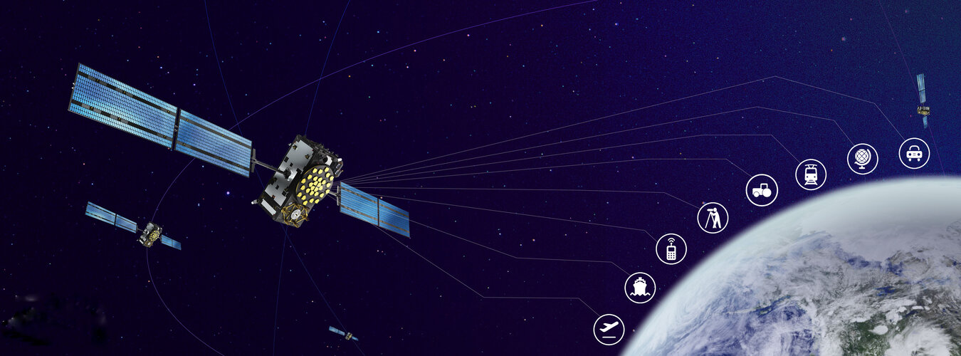
Europe’s latest Galileo satellites in space have joined the operational constellation, transmitting navigation signals to three billion users across planet Earth as well as relaying distress calls to rescuers. Their entry into service follows a summer test campaign and will result in a measurable increase in positioning accuracy and improved data delivery performance of the overall Galileo system.
ESA technology leading to safer, smarter European roads
23.8.2022 13:40
An agreement signed yesterday looks to extend the use of ESA space technology along European roads. The Agency’s Navigation Directorate has finalised a Memorandum of Intent with ERTICO, the organisation for the European Road Transport Telematics Implementation Coordination, a public-private partnership focused on the development, promotion and connection of intelligent road systems and services.
ESA technology for safer, smarter European roads
23.8.2022 13:40
An agreement signed yesterday looks to extend the use of ESA space technology along European roads. The Agency’s Navigation Directorate has finalised a Memorandum of Intent with ERTICO, the organisation for the European Road Transport Telematics Implementation Coordination, a public-private partnership focused on the development, promotion and connection of intelligent road systems and services.
ESA testing sensor network for smart city navigation
4.8.2022 10:27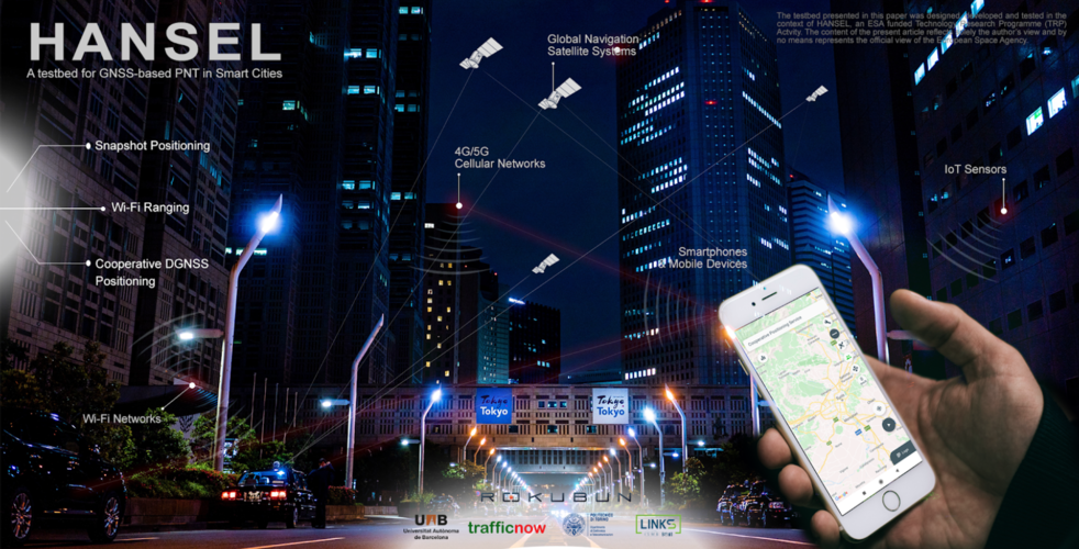
New infrastructure added to ESA’s ESTEC technical centre in the Netherlands is helping to test how tomorrow’s smart cities will operate in practice. The HANSEL system is hosted in ESTEC’s Navigation Laboratory and allows linking to sensors across the site, providing insight into the collective networking and computing needed to get a variety of ‘intelligent elements’ to mesh seamlessly together – what the brain of a future smart city might look like.
Sharpening satnav for smartphones
19.7.2022 9:24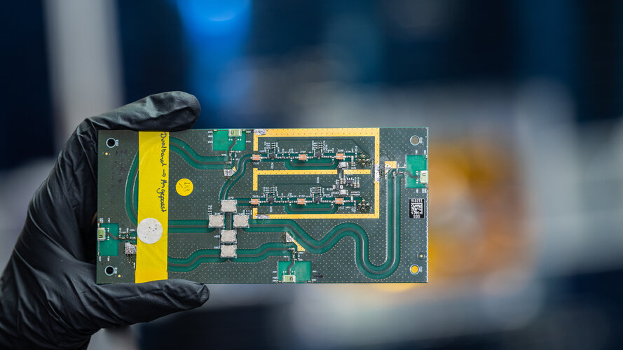
Satellite navigation has transformed the way people live and work, but because the majority of us access it via our smartphones, the actual precision of positioning that we end up with has plenty of room for improvement. ESA led a project investigating if an array antenna approach borrowed from satellite design might deliver enhanced positioning for future smartphones, tablets, drones and other mass-market devices.
Galileo 2nd Generation takes 11 leaps forward
14.7.2022 14:25
Europe’s Galileo constellation is already the world’s most precise satellite navigation system, but now Galileo Second Generation, G2, is coming. A set of 11 procurements – adding up to a maximum of up to approximately 950 million euros – are being released over the course of July by ESA, aiming for this next generation satnav system to begin operations and provide new capabilities later in this decade.
Galileo Second Generation takes 11 leaps forward
14.7.2022 14:25
Europe’s Galileo constellation is already the world’s most precise satellite navigation system, but now Galileo Second Generation, G2, is coming. A set of 11 procurements – adding up to a maximum of up to approximately 950 million euros – are being released over the course of July by ESA, aiming for this next generation satnav system to begin operations and provide new capabilities later in this decade.
Smart competition for clever navigation at NAVISP Industry Days
7.7.2022 13:45
Europe’s leading companies and research institutes working on positioning, navigation, and timing (PNT) technologies met at ESA’s technical heart in the Netherlands in mid-June for this year’s NAVISP Industry Days, devoted to the latest developments in the Agency’s Navigation Innovation and Support Programme.
New navigation missions for enhanced satnav and Earth mapping
6.7.2022 13:22
ESA’s Navigation Directorate – already the design architect of the Galileo satellite navigation system, Europe’s largest satellite constellation – is reaching out to European industry as it plans the development and in-orbit validation of future ‘positioning, navigation and timing’ (PNT) missions into novel orbits.
EGNOS technology for Africa – ESA signs deal with ASECNA
29.6.2022 17:10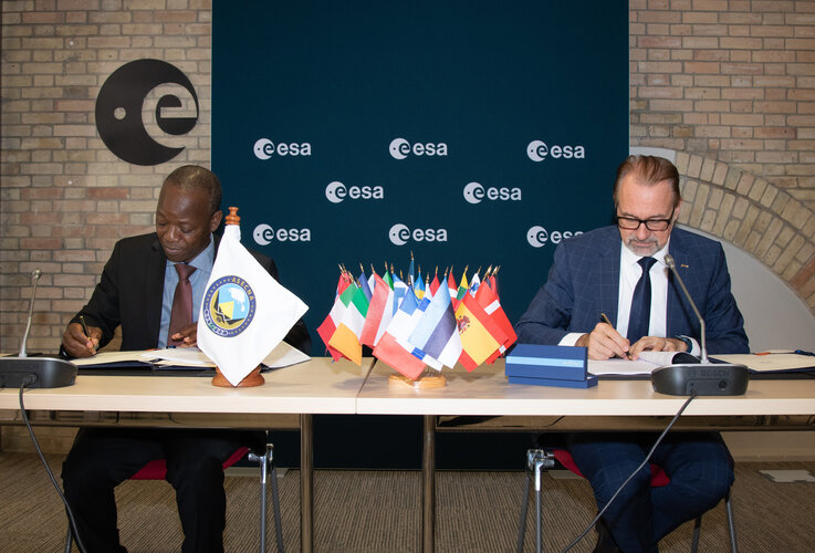
European technology that allows satellite navigation signals to safely guide aircraft down for landing in the majority of Europe’s airports will now be put to use across Africa and the Indian Ocean. ASECNA, the Agency for Air Navigation Safety in Africa and Madagascar, and ESA today signed an agreement to deploy a Satellite-based Augmentation System (SBAS) across a service region of more than 16.5 million sq. km, one and a half times the size of Europe’s coverage area.
Space tech to be put to test on Asia-bound Fiat Panda
20.6.2022 10:47
Two ESA engineers are offering a unique testbed for novel space technology: a second-hand, two-decade-old Fiat Panda, set to be driven 16 000 km to compete in the Mongol Rally from Europe to the Mongolian steppes during summer 2023. Having already taken part in the Panda Raid race to Morocco and back, the ‘space2ground’ team plans to perform on-board testing over the course of their epic Asiatic drive.
Galileo – a new tool for science
13.6.2022 9:12
Every moment of every day, Europe’s constellation of Galileo navigation satellites that ring our planet transmits precisely shaped and timed signals, down through the atmosphere, reflecting back from Earth’s land, seas and ice and extending far out into space, as far as the Moon.
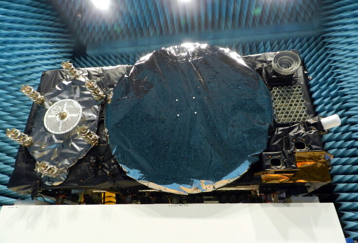 Image:
The face of Galileo
Image:
The face of Galileo
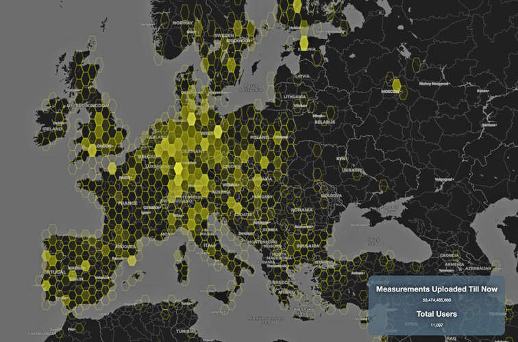 Image:
Volunteers watching the skies
Image:
Volunteers watching the skies
Find your way to the future at ESA’s NAVISP Industry Days
16.5.2022 11:46
After a pandemic-induced gap of more than two years, Europe’s leading companies working on positioning, navigation and timing technologies will meet face-to-face at ESA’s technical heart in the Netherlands for the NAVISP Industry Days, devoted to the latest developments in the Agency’s Navigation Innovation and Support Programme.
Meet the navigation team | Space jobs
5.5.2022 18:00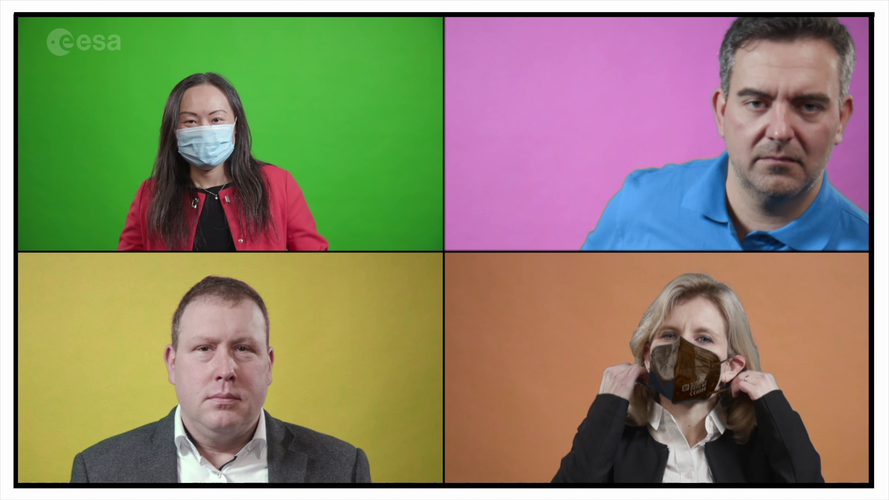 Video:
00:07:13
Video:
00:07:13
Dive into our navigation activities and hear about the projects, goals, challenges and work environment from ESA staff working in the Navigation Directorate and the Directorate for Technology, Engineering and Quality.
Find out more about Careers at ESA: https://careers.esa.int/
ESA’s satnav summer school open to students
22.4.2022 17:44
This year’s ESA/JRC International Summer School on Global Navigation Satellite Systems will take place in July, at Kraków in the South of Poland.
Newest Galileo satellites join working constellation
22.4.2022 16:43
Europe’s latest Galileo navigation satellites in space have completed their post-launch commissioning process, leaving them ready to join the working constellation, transmitting navigation signals across planet Earth as well as relaying distress calls to rescuers.
The Moon – where no satnav has gone before
20.4.2022 15:29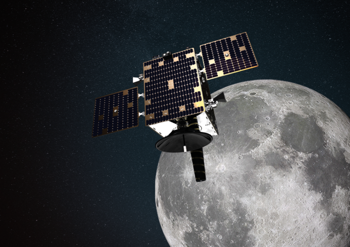
The test version of a unique satellite navigation receiver has been delivered for integration testing on the Lunar Pathfinder spacecraft. The NaviMoon satnav receiver is designed to perform the furthest ever positioning fix from Earth, employing signals that will be millions of times fainter than those used by our smartphones or cars.
The Moon – where no satnav has gone before
20.4.2022 15:29
The test version of a unique satellite navigation receiver has been delivered for integration testing on the Lunar Pathfinder spacecraft. The NaviMoon satnav receiver is designed to perform the farthest ever positioning fix from Earth, employing signals that will be millions of times fainter than those used by our smartphones or cars.
406 Day: how Galileo helps save lives
6.4.2022 9:45
Today is the annual 406 Day, celebrating the life-saving importance of emergency beacons, named for the radio frequency they operate on, as well as the satellites that relay their signals – with Europe’s own Galileo constellation prominent among them. While Galileo’s main purpose is satellite navigation, the system also picks up distress messages from across the globe and relays them to regional search and rescue authorities.
Satellites around the Moon come another step closer
29.3.2022 9:30
ESA is going to the Moon – in collaboration with its international partners – and seeks to build a lasting lunar link to enable sustainable space exploration.
Turn your phone into a space monitoring tool
22.3.2022 16:30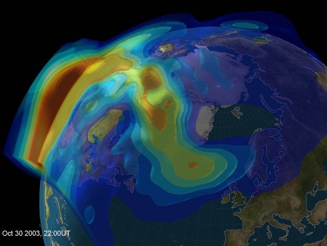
A newly released Android app will turn your smartphone into an instrument for crowdsourced science. Leave it by your window each night with your satnav positioning turned on and your phone will record small variations in satellite signals, gathering data for machine learning analysis of meteorology and space weather patterns.
Satellite navigation signals help map sea surface shape
22.3.2022 12:30 Video:
00:05:00
Video:
00:05:00
Monitoring the constantly changing shape of the sea surface is important for scientific and societal applications such as ocean current forecasting, climate research, ship routing, cable laying, and debris tracking.
A project supported by the Discovery element of ESA’s Basic Activities recently investigated a new technique to measure sea surface topography very precisely. The project was based on an idea submitted by the Institute for Space Studies of Catalonia (IEEC) through the Open Space Innovation Platform (OSIP) – ESA’s place for your space ideas.
The technique involves looking at satellite navigation (GNSS) signals that have been reflected off of the sea surface at very low angles. At these so-called grazing angles, waves and surface roughness have very little impact on the reflection process; the sea surface acts as a very smooth mirror.
IEEC’s Estel Cardellach, principal investigator and submitter of the OSIP idea explains: “In a mirror-like reflection the phase of the signal can be tracked – it is continuous. Different surface heights result in different phase measurements. It gives a very precise measurement of the surface altitude at a few centimetres’ precision.”
The ESA-funded activity involved developing a GNSS receiver and setting up an experiment in the Balaeric Islands to collect GNSS signals reflected off the sea surface. The team – made up of IEEC, imedea, SOCIB and DLR – then processed the signals for optimised measurements of the shape of the sea surface.
“Thanks to OSIP and ESA Discovery we have been able to conduct this experiment on grazing GNSS reflectometry under monitored conditions,” says Manuel Martin-Neira, ESA technical officer for the project. “We have linked the coherence of the reflected signals to wave height and elevation angle of GNSS satellites. These results have been very useful for preparing the PRETTY mission.”
ESA’s PRETTY (Passive REflecTomeTry and dosimetry) CubeSat mission is a small satellite that will carry out grazing angle GNSS altimetry from orbit. It is due to launch later in 2022.
ESA probing navigation via the quantum realm
14.3.2022 13:31
ESA’s NAVISP programme – helping to invent the future of European navigation – is probing the science of the very small. The aim is to employ hyper-sensitive quantum technology-based sensors as supplementary navigation solutions, including tracking local variations in gravity that could be matched onto regional and global gravity maps.
Wanted: your new ideas for navigation
17.2.2022 15:52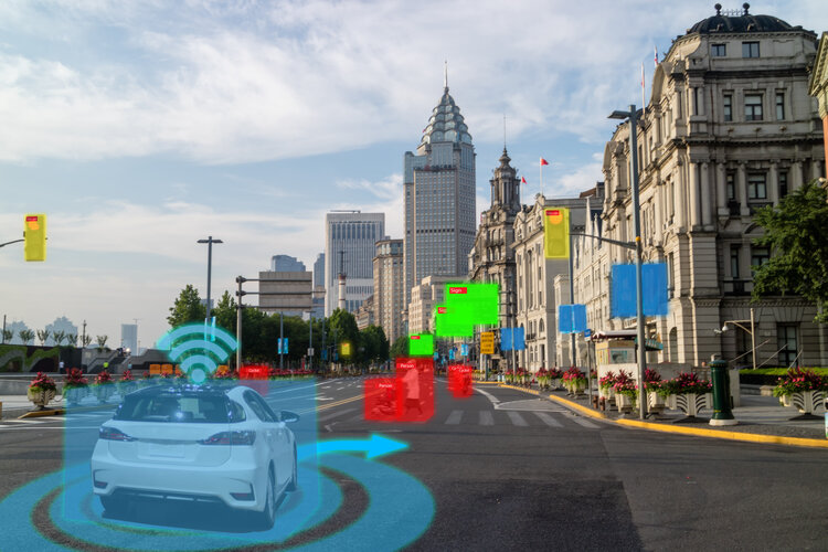
It is hard to overstate the importance of knowing precisely where (and when) you are and where you are going within today’s economy and society. Do you have a promising idea to improve the current positioning state-of-the-art? Then ESA’s navigation-focused NAVISP research programme wants to hear from you, before the end of March.
Inventing the future of Navigation
14.2.2022 14:30 Video:
00:05:15
Video:
00:05:15
Many of the experts that designed and oversaw the Galileo satnav system are now supporting cutting-edge European companies in the development of new navigation technologies and services. The result is ESA’s Navigation Innovation and Support Programme, NAVISP.
NAVISP is looking into all kinds of clever ideas about the future of navigation: ways to improve satellite navigation, alternative positioning systems and, new navigation services and applications. Working in partnership with European industry and researchers, more than 200 NAVISP projects have been initiated so far.
NAVISP is divided into three elements, the first looking into improving and expanding satellite navigation, as well as establishing novel ‘positioning, navigation and timing’ (PNT) services. NAVISP’s second element focuses on innovation for competitiveness, developing all kinds of new PNT products and services. Its third element covers support to Member State priorities, including support for national testbeds and programmes.
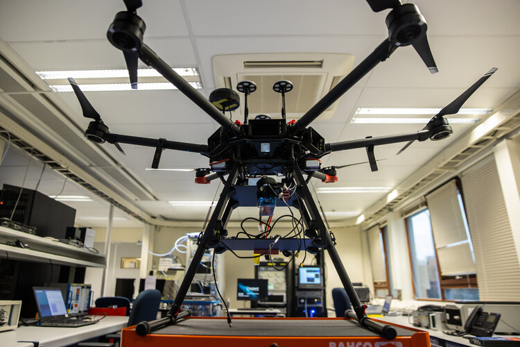 Image:
The drone has landed
Image:
The drone has landed
Two new satellites mark further enlargement of Galileo
5.12.2021 6:59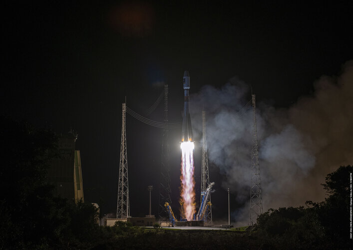
Europe’s largest satellite constellation has grown even bigger, following the launch of two more Galileo navigation satellites by Soyuz launcher from Europe’s Spaceport in French Guiana on 5 December. Galileo satellites 27-28 add to an existing 26-satellite constellation in orbit, providing the world’s most precise satnav positioning to more than 2.3 billion users around the globe.
Galileo launch postponed
4.12.2021 1:34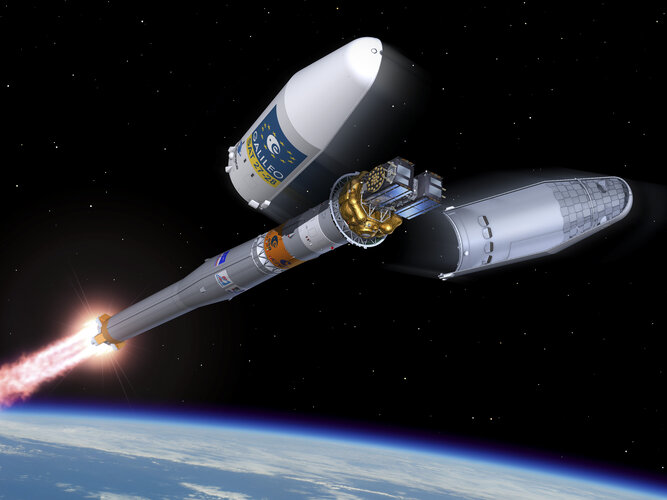
The launch of Europe’s latest Galileo satellites has been postponed. Launch operations were interrupted at H-10 minutes due to adverse weather conditions (lightning). The Soyuz launch vehicle and satellites are in a stable and safe condition.
Watch Galileo launch on night of 4-5 December
4.12.2021 1:34
The launch of Europe’s latest Galileo satellites is now scheduled for the night of 4-5 December.
Watch Galileo launch on night of 4-5 December
4.12.2021 1:34
Galileo satellites 27 – 28 lifted off by Soyuz launcher VS26 from Europe’s Spaceport in French Guiana at 01:19 CET on 5 December (4 December at 21:19 local Kourou time). Follow the launch live on ESA Web TV Two.
Watch Galileo launch on night of 2-3 December
2.12.2021 10:34
The launch of Europe’s latest Galileo satellites is now due to take place tonight, very early on Friday morning. The original launch date was postponed due to adverse weather conditions at the launch site.
Galileo launch postponed
2.12.2021 10:34
Due to unavailability of a downrange tracking station, Arianespace has taken the decision to postpone the fueling of Galileo's three stage Soyuz launcher. The VS26 Soyuz launch vehicle and the satellites are in a stable and safe condition.
Watch Galileo launch on night of 3-4 December
2.12.2021 10:34
The earliest launch date for Europe’s latest Galileo satellites is now during the night of 3-4 December.
Watch Galileo launch on night of 3-4 December
2.12.2021 10:34
Europe’s latest Galileo satellites will be launched on the night of 3-4 December. Arianespace has taken the decision to begin fuelling their three-stage Soyuz launcher.
12 things you never knew about Galileo satellites
2.12.2021 10:12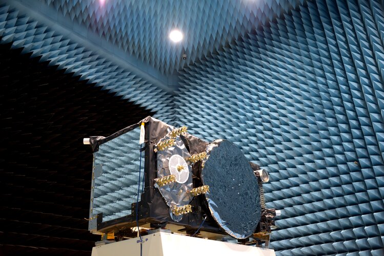
Europe’s Galileo satellite navigation system is providing the world’s most precise positioning services, but the satellites at its heart are surprisingly compact, and dependent on many different technologies to keep running. Here are 12 things you probably didn’t know about them:
Galileo satellites placed on Soyuz launcher
30.11.2021 13:28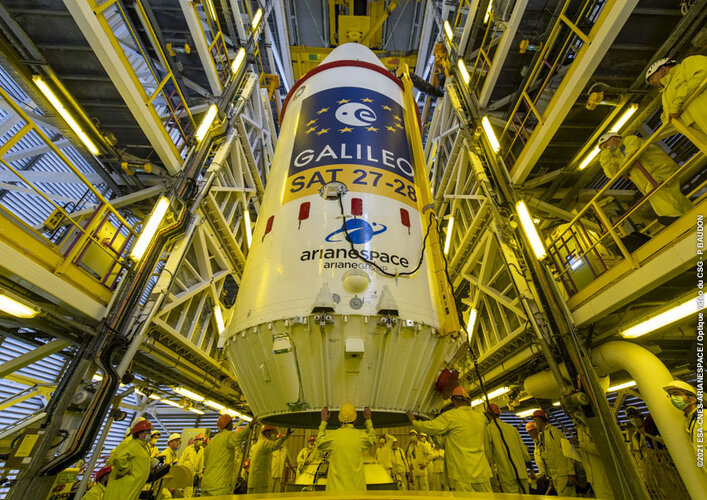 Image:
Galileo satellites placed on Soyuz launcher
Image:
Galileo satellites placed on Soyuz launcher
Galileo satellites given green light for launch
29.11.2021 10:16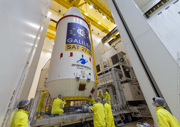
Europe’s next pair of Galileo satellites have been given a green light for launch. Last Friday’s Launch Readiness Review confirmed that the satellites, the supporting ground installations, and the early operations facilities and teams are ready for lift-off on the early hours of Thursday morning, European time.
Galileo satellites given green light for launch
29.11.2021 10:16
UPDATE: GALILEO LAUNCH NOW SCHEDULED FOR 3 DECEMBER AT 0127 CET (2 DECEMBER 2127 KOUROU TIME)
Europe’s next pair of Galileo satellites have been given a green light for launch. Last Friday’s Launch Readiness Review confirmed that the satellites, the supporting ground installations, and the early operations facilities and teams are ready for lift-off on the early hours of Thursday morning, European time.
Galileo satellites given green light for launch
29.11.2021 10:16
UPDATE: GALILEO LAUNCH NOW SCHEDULED FOR 3 DECEMBER AT 01:27 CET (2 DECEMBER 21:27 KOUROU TIME)
Europe’s next pair of Galileo satellites have been given a green light for launch. Last Friday’s Launch Readiness Review confirmed that the satellites, the supporting ground installations, and the early operations facilities and teams are ready for lift-off on the early hours of Thursday morning, European time.
Galileo: en route to full operational capability
26.11.2021 13:00 Video:
00:05:36
Video:
00:05:36
Soon another pair of Galileo satellites will be launched on top of a Soyuz from Europe spaceport in French Guiana. These satellites are the first of the so-called 'Batch 3', comprising of 12 additional first-generation Galileo satellites commissioned in 2017 to bring the constellation to full operational capability. They will be used to further expand the constellation up to 38 satellites and act as backups and spares for satellites that reach their end-of-life.
This 11th Galileo launch also marks the 10 year anniversary of the first launch of the Galileo operational satellites and the start of the construction of the constellation. Ten years later Galileo is the most accurate satellite navigation system in the world and available on every recent smartphone and device. It is also two decades since satellite navigation was first introduced as a completely new activity in the European space sector.
Meanwhile ESA continues to ensure the future of the Galileo programme and European expertise in satellite navigation. For Galileo ESA has already commissioned a second generation of more powerful and flexible navigation satellites while new services are being developed to meet market demand.
Galileos attached to upper stage as launch draws near
25.11.2021 17:24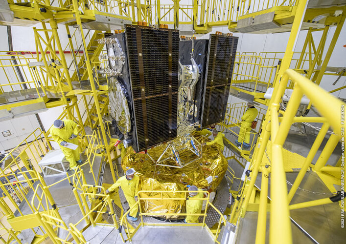 Image:
Galileos attached to upper stage as launch draws near
Image:
Galileos attached to upper stage as launch draws near
Galileo satellites in place for launch
25.11.2021 17:08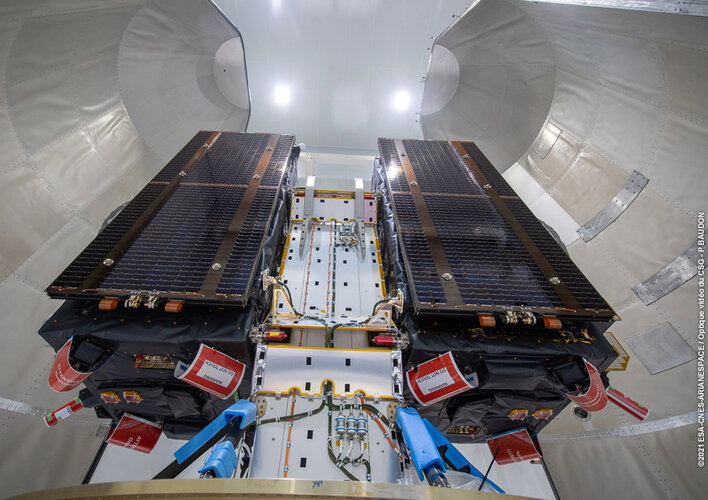
Europe’s next two Galileo satellites have been attached to the dispenser on which they will ride to orbit, and the launcher fairing that will protect them during the first part of the ascent to orbit has been closed around the pair.
Galileo prototype GIOVE-A switched off after 16 years in orbit
24.11.2021 13:00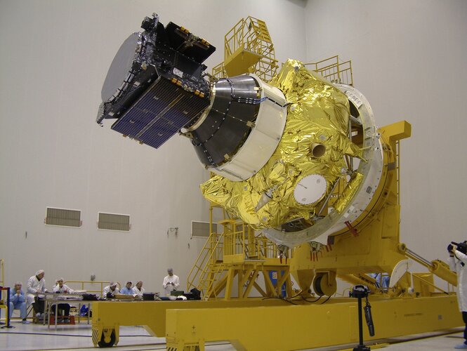
Europe’s first prototype satellite for Galileo, GIOVE-A, has today been formally decommissioned after 16 years of work in orbit. The 2005-launched mission secured Galileo’s radio frequencies for Europe, demonstrated key hardware and probed the then-unknown radiation environment of medium-Earth orbit.
Galileo Control Segment upgrade ready for next launch
25.10.2021 13:58
A significant first for next month’s 11th Galileo launch: thanks to an upgrade of the world-spanning Galileo Control Segment, this will be the first launch where the satellites ‘ first steps into space will be overseen from an existing Galileo Control Centre, rather than requiring an external mission control site.
Galileo: the first ten years
21.10.2021 12:30 Video:
00:01:25
Video:
00:01:25
Europe’s own satellite navigation system, Galileo, has become the world’s most precise, delivering metre-level accuracy, available anywhere on Earth. It is also saving lives, relaying distress calls for search and rescue. Today there are 26 Galileo satellites in orbit 23 222 km over our heads; the first of them were launched on 21 October 2011, with nine more launches in the following years. The satellites in space are supported by a globe-spanning ground segment. The system as a whole is set to grow, with the first of 12 ‘Batch 3’ about to join the current satellites in orbit and new ‘Galileo Second Generation’ satellites in development.
Galileo has been financed by the EU and developed by ESA, with services delivered by EUSPA.
Galileo satellites arrive at Europe’s Spaceport
8.10.2021 9:20
The latest pair of Galileo satellites have touched down at Europe’s Spaceport in French Guiana, ahead of their launch together next month.
New angle on reflected satnav yields sharper sea tracking
8.9.2021 16:48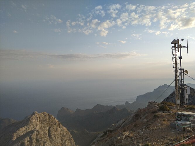
An experimental satellite navigation receiver station high atop Spain’s Mallorca island has opened up a novel view of the ever-changing face of the sea. By picking up satnav signals from the far horizon as they bounce off ocean waves, the receivers are able to measure sea surface height down to a scale of centimetres.
 Image:
EC Commissioner Breton visits ESTEC
Image:
EC Commissioner Breton visits ESTEC
EC Commissioner Breton visits ESA-ESTEC
8.9.2021 11:33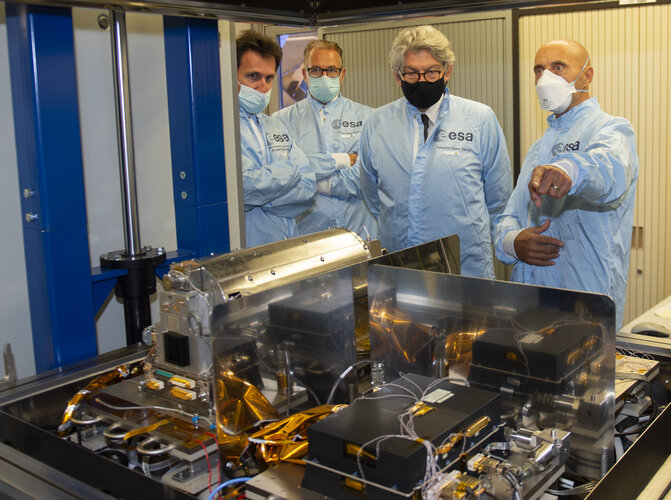 Image:
EC Commissioner Breton visits ESA-ESTEC
Image:
EC Commissioner Breton visits ESA-ESTEC
Join our online event: Galileo Second Generation Industry Day on 7th September
26.8.2021 15:27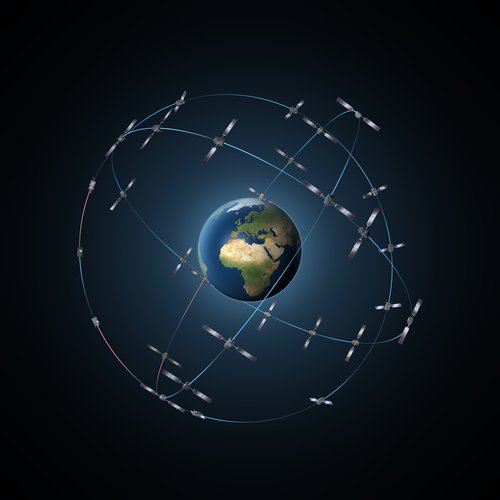
As work proceeds on Europe's Galileo Second Generation satellites, the European Space Agency is pleased to announce the Galileo Second Generation Industry Day 2021 online event on Tuesday 7 September.
Galileo Second Generation proof-of-concept testing begins
19.7.2021 16:56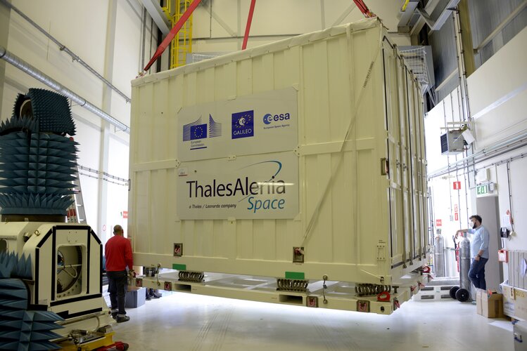
The first Galileo Second Generation hardware has begun testing, with test versions of the satellites’ navigation payloads undergoing evaluation by Airbus Defence and Space at their Ottobrunn facility in Germany and by Thales Alenia Space at ESA’s ESTEC technical centre in the Netherlands.
Call for ideas to augment satnav with imaging sensors & 3D maps
14.6.2021 15:01
Update: NAVISP webinar replay now added below
Busy urban centres represent key areas of demand for satellite navigation services, but dense concentrations of high buildings mean that satnav signal reception may sometimes fall short. So ESA is issuing a call for ideas to make up for such service gaps through the use of imaging and 3D mapping technology – ahead of a dedicated workshop on 6 July.
Call for ideas to augment satnav with imaging sensors & 3D maps
14.6.2021 15:01
Busy urban centres represent key areas of demand for satellite navigation services, but dense concentrations of high buildings mean that satnav signal reception may sometimes fall short. So ESA is issuing a call for ideas to make up for such service gaps through the use of imaging and 3D mapping technology – ahead of a dedicated workshop on 6 July.
Galileo satellites’ last step before launch
3.6.2021 13:04
Europe’s Galileo satellite navigation constellation is set to grow. Later this year the first two out of 12 ‘Batch 3’ Galileo satellites will be launched by Soyuz from French Guiana. Their last step on the way to launch is situated beside sand dunes on the Dutch coast: the ESTEC Test Centre, which is Europe’s largest satellite test facility.
ESA signs contract for new generation of Galileo
28.5.2021 9:14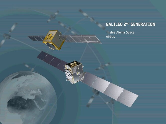
Acting on behalf of the European Commission, ESA has signed two contracts for an overall amount of €1.47 billion, to design and build the first batch of the second generation of Europe’s Galileo navigation satellites.
Lunch with the Moon
27.5.2021 12:30 Video:
03:32:49
Video:
03:32:49
For the first time in more than three years, on 26 May 2021, a total lunar eclipse coincided with a supermoon. The 'super blood moon' was unfortunately only visible across Australia and parts of the US and East Asia. But ESA, in cooperation with the Australian science agency, CSIRO, brought this celestial treat to European viewers through its live webcast "Lunch with the Moon".
Catch the replay of this unique event, which includes live footage of the Moon from across the globe and conversations with experts on the science of lunar eclipses, what would happen if there were no Moon, fascinating insights into Europe's future at the Moon including the Moonlight project, lunar robots and robotics, a future human lunar base and much more.
Lunch with the Moon
27.5.2021 12:30
Video:
03:32:49
For the first time in more than three years, on 26 May 2021, a total lunar eclipse coincided with a supermoon. The 'super blood moon' was unfortunately only visible across Australia and parts of the US and East Asia. But ESA, in cooperation with the Australian science agency, CSIRO, brought this celestial treat to European viewers through its live webcast "Lunch with the Moon".
Catch the replay of this unique event, which includes live footage of the Moon from across the globe and conversations with experts on the science of lunar eclipses, what would happen if there were no Moon, fascinating insights into Europe's future at the Moon including the Moonlight project, lunar robots and robotics, a future human lunar base and much more.
In the programme, the moment of “totality” – when the Moon is fully shrouded in Earth’s shadow – begins around 1:46:00.
Schedule
02:10 Deep-space communication from Australia
13:00 All about lunar eclipses
29:10 What if there were no Moon?
43:20 Europe goes forward to the Moon
58:45 Moonlight: Connecting Earth with the Moon
1:13:20 Humans at work in a lunar setting
1:28:20 Lunar robots
1:43:45 Science and future exploration
Infographic: Moonlight - Navigation for the Moon
20.5.2021 16:09 Image:
Infographic: Infographic: Moonlight - Navigation for the Moon
Image:
Infographic: Infographic: Moonlight - Navigation for the Moon
ESA advances its plan for satellites around the Moon
20.5.2021 14:00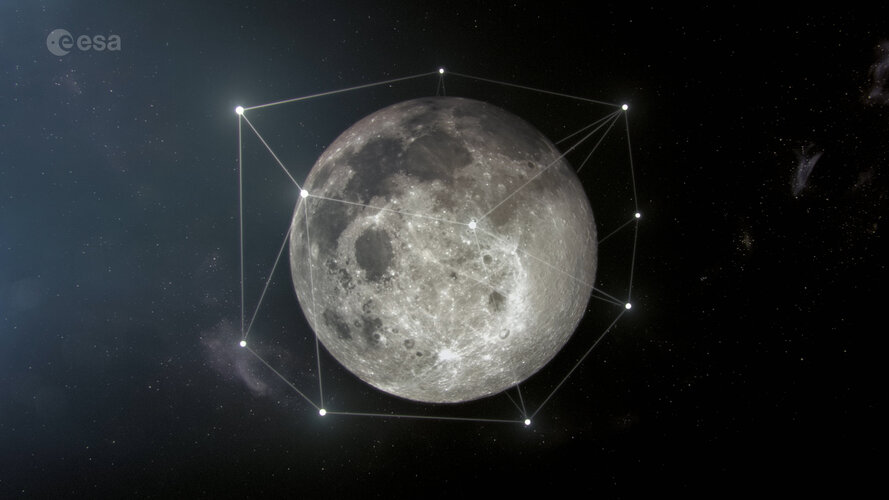
A bold proposal to create a commercially viable constellation of lunar satellites has taken a step closer.
ESA-backed autonomous driving lab set for Italy
23.4.2021 10:10
Central Italy – already home to an ambitious national autonomous driving research initiative – will be the site of the ESA-backed P-CARS laboratory, intended to certify positioning devices for use within driverless cars.
Video: How Galileo works, for its 2 billion global users
20.4.2021 7:20
Video: How Galileo works, for its 2 billion global users
406 Day: celebrating Galileo saving lives
6.4.2021 12:30
Today is 406 Day – the annual campaigning day to spread awareness of the importance of emergency beacons, and the satellites that pick up their signals, including Europe’s Galileo constellation. As well as letting people across the world find their way, Galileo also serves to detect SOS messages and relay them to authorities, contributing to saving many lives.
Galileo will help Lunar Pathfinder navigate around Moon
18.3.2021 15:16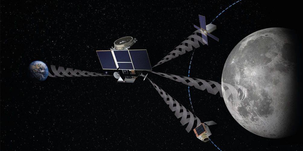
ESA’s Lunar Pathfinder mission to the Moon will carry an advanced satellite navigation receiver, in order to perform the first ever satnav positioning fix in lunar orbit. This experimental payload marks a preliminary step in an ambitious ESA plan to expand reliable satnav coverage – as well as communications links – to explorers around and ultimately on the Moon during this decade.
Galileo will help Lunar Pathfinder navigate around Moon
18.3.2021 15:16
ESA’s Lunar Pathfinder mission to the Moon will carry an advanced satellite navigation receiver, in order to perform the first ever satnav positioning fix in lunar orbit. This experimental payload marks a preliminary step in an ambitious ESA plan to expand reliable satnav coverage – as well as communication links – to explorers around and ultimately on the Moon during this decade.
Ten years of safer skies with Europe’s other satellite navigation system
17.3.2021 11:02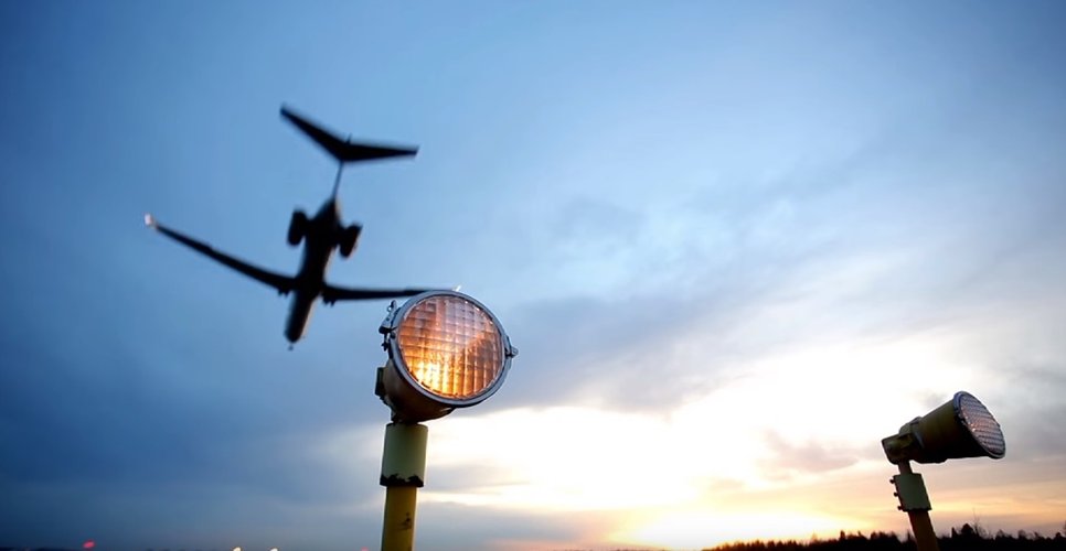
With 26 satellites in orbit and more than two billion receivers in use, Europe’s Galileo satellite navigation system has made a massive impact. But our continent has another satnav system that has been providing safety-of-life services for ten years now – chances are that you’ve benefited from it without noticing.
Ten years of safer skies with Europe’s other satnav system
17.3.2021 11:02
With 26 satellites in orbit and more than two billion receivers in use, Europe’s Galileo satellite navigation system has made a massive impact. But our continent has another satnav system that has been providing safety-of-life services for ten years now – chances are that you’ve benefited from it without noticing.
How Galileo performed first-ever authenticated positioning fix
10.3.2021 12:40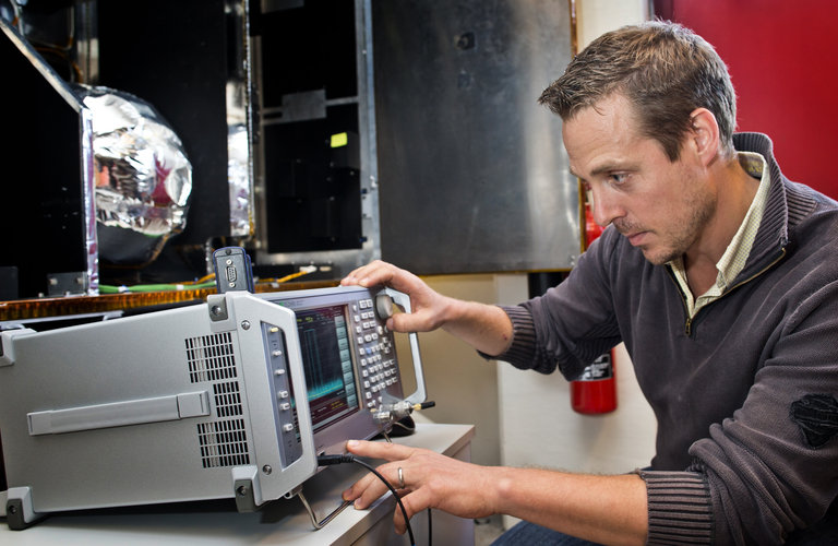
In a first for any satellite navigation system, Galileo has achieved a positioning fix based on open-service navigation signals carrying authenticated data. Intended as a way to combat malicious ‘spoofing’ of satnav signals, this authentication testing began at ESA’s Navigation Laboratory – the same site where the very first Galileo positioning fix took place back in 2013.
How Galileo performed first-ever authenticated positioning fix
10.3.2021 12:40
In a first for any satellite navigation system, Galileo has achieved the first positioning fix based on open-service navigation signals carrying authenticated data. Intended as a way to combat malicious ‘spoofing’ of satnav signals, this authentication testing began at ESA’s Navigation Laboratory – the same site where the very first Galileo positioning fix took place back in 2013.
How Galileo performed first-ever authenticated positioning fix
10.3.2021 12:40
In a first for any satellite navigation system, Galileo has achieved a positioning fix based on open-service navigation signals carrying authenticated data. Intended as a way to combat malicious ‘spoofing’ of satnav signals, this authentication testing began at ESA’s Navigation Laboratory – the same site where the very first Galileo positioning fix took place back in 2013.
Join ESA’s virtual workshop on 5G plus satnav
23.2.2021 8:30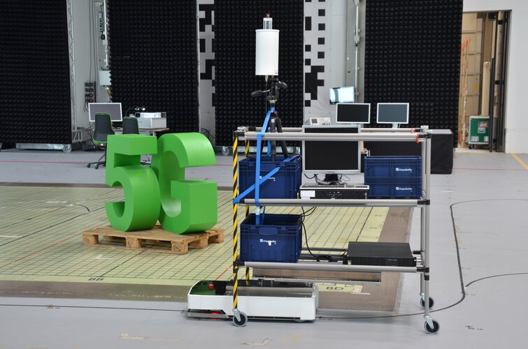
The coming of 5G promises much more than simply better-than-wi-fi smartphone connectivity; it should enable a wide range of novel services, including asset tracking, autonomous driving and drone flying as well as the internet of things. Highly precise localisation is needed to make such innovations feasible however. ESA has led a major project assessing the potential of 5G and satellite navigation in combination and next month a webinar will make its initial findings public.
Galileo/GNSS vacancies at ESA
22.2.2021 17:00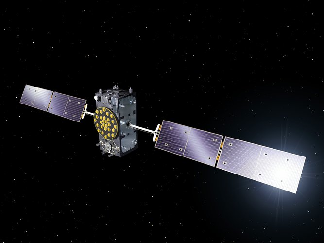
We are looking for Global Navigation Satellite System experts to join our team and support the design and development of the next generation of satellites for Europe’s GNSS System, Galileo. If you have experience in GNSS systems, space systems, project planning or Galileo architecture read on to find out more.
Tests of Galileo Open Service Navigation Message Authentication underway
11.2.2021 9:07
Galileo has started testing Open Service Navigation Message Authentication (OSNMA) in its signal-in-space, allowing the first-ever OSNMA-protected position fix to be successfully computed. Testing will continue over the next months, ahead of a so-called ‘public observation’ phase. This is the first-ever transmission of authentication features in open GNSS signals of a global navigation system.
Satnav antenna built for ends of the Earth
27.1.2021 9:07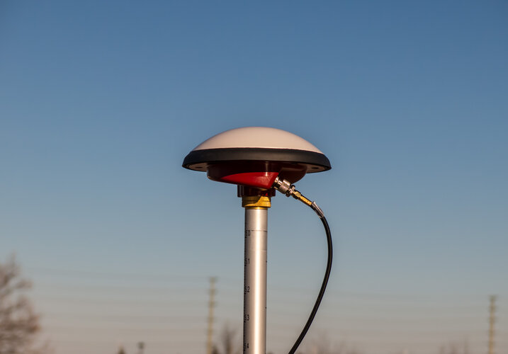
A new ESA-supported wide-bandwidth satnav antenna has been designed to receive both satellite and augmentation signals from anywhere in the sky, even down to just a couple of degrees above the horizon.
Autonomous driving on intelligent road at Europe’s edge
13.1.2021 9:41
An ESA-supported effort put an intelligent road up in Finnish Lapland through its paces, assessing its suitability for testing autonomous vehicles in some of Europe’s most challenging driving conditions.