


![]()

ESA Observing the Earth 
zdroje zpráv:
Satellites increasingly critical to monitor ocean health
22.2.2024 11:45
Playing a huge role in moderating the climate, oceans are fundamental to the functioning of our planet. Understanding more about how seawater temperatures are rising and how oceans are absorbing excess atmospheric carbon dioxide, as well as knock-on issues such as ocean acidification, is key for understanding climate change and for taking effective action.
A recent scientific paper highlights just how satellites are becoming increasingly important in providing unique information on ocean health to guide climate mitigation and adaptation efforts.

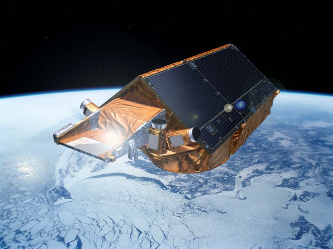
NanoMagSat and Tango Scout missions get go-ahead
21.2.2024 8:00
Further embracing the New Space era, ESA is to develop two new Scout satellites: NanoMagSat and Tango. NanoMagSat will measure Earth’s magnetic field to help assess space weather hazards and continue on from ESA’s current Swarm mission. Tango will measure greenhouse-gas emissions from human activity and complements the upcoming Copernicus Carbon Dioxide Monitoring mission and the Sentinel-5 mission, as well as the current Sentinel-5P mission.
Tobago oil spill
16.2.2024 13:28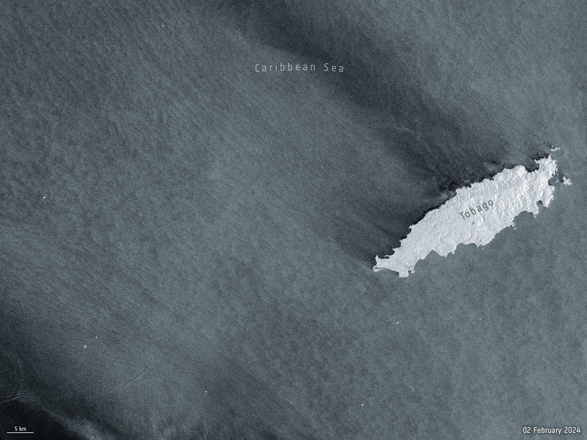 Image:
Before and after satellite images from the Copernicus Sentinel-1 mission show the scale of the oil spill that occurred off the shores of Trinidad and Tobago’s coastline earlier this week.
Image:
Before and after satellite images from the Copernicus Sentinel-1 mission show the scale of the oil spill that occurred off the shores of Trinidad and Tobago’s coastline earlier this week.
Earth from Space: Côte d'Ivoire
16.2.2024 10:00 Image:
The Copernicus Sentinel-2 mission takes us over Côte d'Ivoire in western Africa.
Image:
The Copernicus Sentinel-2 mission takes us over Côte d'Ivoire in western Africa.
What does a warming Arctic mean for the future?
15.2.2024 16:00 Video:
00:12:27
Video:
00:12:27
The Arctic is experiencing disproportionately higher temperature increases compared to the rest of the planet, triggering a series of cascading effects. This rapid warming has profound implications for global climate patterns, human populations and wildlife.
The Copernicus Imaging Microwave Radiometer mission (CIMR) will provide measurements to decision makers with evidence of change and impact in the polar regions – with a focus on the Arctic.
The mission has the largest radiometer developed by ESA and will provide high-resolution measurements related to sea ice, the ocean, snow and ice-sheet surfaces. This will be crucial in understanding the evolution of the climate in the polar region.
CIMR is one of six Copernicus Sentinel Expansion missions that ESA is developing on behalf of the EU. The missions will expand the current capabilities of the Copernicus Space Component – the world’s biggest supplier of Earth observation data.
This video features interviews with Craig Donlon, CIMR Mission Scientist, Rolv Midthassel, CIMR Payload Manager, Claudio Galeazzi, CIMR Project Manager, Mariel Triggianese, CIMR Satellite Engineering and AIV Manager, and Marcello Sallusti, CIMR System Performance and Operations Manager.
In the meantime Craig has changed his role but will retain his position as Mission Scientist.
Access all "Unpacking Sentinels" videos.
What does a warming Arctic mean for the future?
15.2.2024 16:00
Video:
00:12:27
The Arctic is experiencing disproportionately higher temperature increases compared to the rest of the planet, triggering a series of cascading effects. This rapid warming has profound implications for global climate patterns, human populations and wildlife.
The Copernicus Imaging Microwave Radiometer mission (CIMR) will provide measurements to decision makers with evidence of change and impact in the polar regions – with a focus on the Arctic.
The mission has the largest radiometer developed by ESA and will provide high-resolution measurements related to sea ice, the ocean, snow and ice-sheet surfaces. This will be crucial in understanding the evolution of the climate in the polar region.
CIMR is one of six Copernicus Sentinel Expansion missions that ESA is developing on behalf of the EU. The missions will expand the current capabilities of the Copernicus Space Component – the world’s biggest supplier of Earth observation data.
This video features interviews with Craig Donlon, CIMR Mission Scientist, Rolv Midthassel, CIMR Payload Manager, Claudio Galeazzi, CIMR Project Manager, Mariel Triggianese, CIMR Satellite Engineering and AIV Manager, and Marcello Sallusti, CIMR System Performance and Operations Manager.
In the meantime Craig has changed his role but will retain his position as Mission Scientist.
 Image:
Saying goodbye to ERS-2
Image:
Saying goodbye to ERS-2
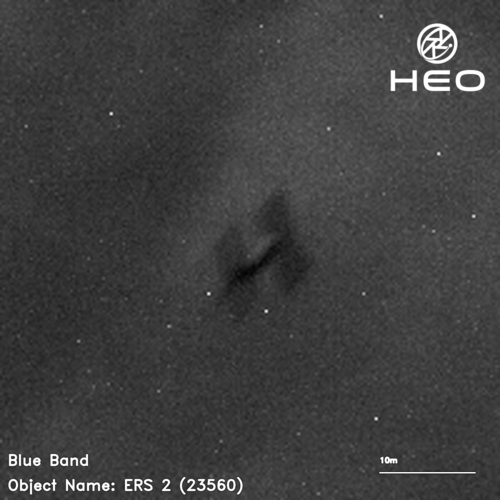
ERS-2 reentry – how and why is it happening?
15.2.2024 9:30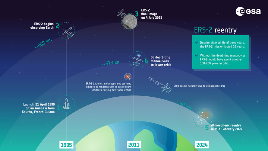 Image:
ERS-2 reentry – how and why is it happening?
Image:
ERS-2 reentry – how and why is it happening?
Air pollution fluctuations over the Po Valley
13.2.2024 15:49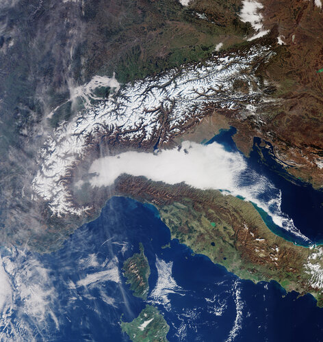
The Po Valley, nestled in northern Italy, is renowned for its picturesque landscapes and rich agricultural history. However, the region is also grappling with a persistent environmental challenge: air pollution. The unique geographical and meteorological conditions of the Po Valley contribute to fluctuations in air quality – impacting the health of its residents.
Earth from Space: South Atlantic bloom
9.2.2024 10:00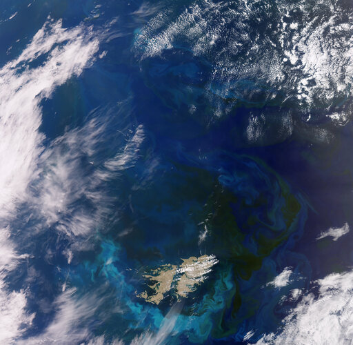 Image:
This wide view from the Copernicus Sentinel-3 mission captures an algae bloom around the Falkland Islands in the South Atlantic Ocean.
Image:
This wide view from the Copernicus Sentinel-3 mission captures an algae bloom around the Falkland Islands in the South Atlantic Ocean.
Heritage ERS-2 satellite to reenter Earth’s atmosphere
5.2.2024 12:00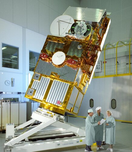
Throughout its 16-year working life, the second European Remote Sensing satellite, ERS-2, returned a wealth of information that revolutionised our perspective of our planet and understanding of climate change. As well as leaving a remarkable legacy of data that still continue to advance science, this outstanding mission set the stage for many of today’s satellites and ESA’s position at the forefront of Earth observation.
In 2011, ESA retired ERS-2 and began the process of deorbiting – and now it’s time for this pioneering satellite to reenter the atmosphere naturally and start to burn up.
Earth from Space: Dubai
2.2.2024 10:00 Image:
This false-colour image acquired by the Copernicus Sentinel-2 mission shows the city of Dubai and its surroundings in the United Arab Emirates.
Image:
This false-colour image acquired by the Copernicus Sentinel-2 mission shows the city of Dubai and its surroundings in the United Arab Emirates.
ESA’s cloud mission in the limelight
1.2.2024 11:00
Dedicated to delivering a wealth of new information on exactly how clouds and aerosols affect Earth’s climate, ESA’s EarthCARE satellite has had the chance to show off prior to engineers embarking upon the careful task of packing it up for its journey to the launch site in the US.
Earth from Space: Snow-bound eastern US
26.1.2024 10:00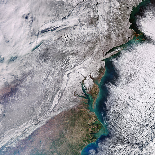 Image:
Record-breaking Arctic cold weather has swept through much of the United States in the last few weeks. The eastern part of the country was particularly affected with thick snow blanketing most of the region, as this Copernicus Sentinel-3 image shows.
Image:
Record-breaking Arctic cold weather has swept through much of the United States in the last few weeks. The eastern part of the country was particularly affected with thick snow blanketing most of the region, as this Copernicus Sentinel-3 image shows.
World’s largest iceberg drifts beyond Antarctic waters
25.1.2024 14:50 Video:
00:00:20
Video:
00:00:20
In November 2023, the A23a mega iceberg set sail after being grounded on the ocean floor for well over 40 years. Now, driven by winds and currents, A23a is heading away from Antarctic waters as seen in this new animation.
The iceberg calved from West Antarctica in 1986 but quickly grounded itself in the Weddell Sea where it remained for over four decades. At around 4000 sq km in area, more than four times the size of New York City, and just over 280 m thick, the berg currently holds the title for world’s largest iceberg.
The animation uses sea-ice concentration data and shows the iceberg’s movements between 1 November 2023 to 23 January 2024. Similar to many icebergs originating from the Weddell sector, A23a is likely to be expelled into the Antarctic Circumpolar Current – propelling it towards the South Atlantic along a trajectory commonly referred to as ‘iceberg alley’.
Sentinel-1 and AI reveal 75% of fishing vessels not tracked
24.1.2024 9:00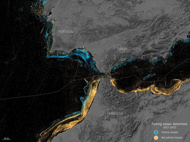
A groundbreaking study that combines satellite data and Artificial Intelligence has thrown new light on the number of vessels at sea. Astonishingly, the study reveals that around 75% of the world's industrial fishing vessels have previously been ‘dark’ to public tracking systems.
Earth from Space: Columbia Glacier, Alaska
19.1.2024 10:00 Image:
The Copernicus Sentinel-2 mission takes us over Alaska’s Columbia Glacier, one of the fastest changing glaciers in the world.
Image:
The Copernicus Sentinel-2 mission takes us over Alaska’s Columbia Glacier, one of the fastest changing glaciers in the world.
Media invitation: Last chance to see the EarthCARE satellite
12.1.2024 10:36
Media invitation: Last chance to see the EarthCARE satellite
Top 10 Earth observation stories of 2023
20.12.2023 11:50
This year has been a whirlwind of captivating Earth observation stories and news, spanning from dramatic volcanic eruptions to powerful earthquakes to witnessing icebergs on the run. Join us as we revisit some of the most memorable stories from 2023.
Earth from Space: Icy landscape
15.12.2023 10:00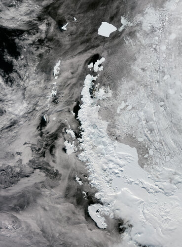 Image:
As the holiday season swiftly approaches, frosty landscapes tend to be associated with the magical idea of a white Christmas. But this Copernicus Sentinel-3 image over the Antarctica Peninsula sheds light on a different perspective.
Image:
As the holiday season swiftly approaches, frosty landscapes tend to be associated with the magical idea of a white Christmas. But this Copernicus Sentinel-3 image over the Antarctica Peninsula sheds light on a different perspective.
Earth from Space: Icy landscape
15.12.2023 10:00
Image:
As the holiday season swiftly approaches, frosty landscapes tend to be associated with the magical idea of a white Christmas. But this Copernicus Sentinel-3 image over the Antarctic Peninsula sheds light on a different perspective.
ESA forges ahead with Destination Earth
14.12.2023 14:00
The second phase of the European Union’s Destination Earth initiative has been approved at ESA Council. Destination Earth, also known as DestinE, will build digital models of Earth allowing greater insight into weather and climate dynamics and their impacts on society.
Permafrost thaw: a silent menace
12.12.2023 12:00 Video:
00:05:47
Video:
00:05:47
Ice is without doubt one of the first casualties of climate change, but the effects of our warming world are not only limited to ice melting on Earth’s surface. Ground that has been frozen for thousands of years, called permafrost, is thawing – adding to the climate crisis and causing serious issues for local communities.
Scientists estimate that the world’s permafrost holds almost double the amount of carbon that is currently in the atmosphere. When permafrost warms and thaws, it releases methane and carbon dioxide, adding these greenhouse gases to the atmosphere and making global warming even worse.
While permafrost cannot be directly observed from space, a lot of different types of satellite data, along with ground measurements and modelling, allow scientists to paint a picture of permafrost ground conditions.
Little Pictures winner announced at COP28
11.12.2023 14:35
The winning entry to a Europe-wide data visualisation contest was announced and showcased last week at COP28. The ‘Little Pictures’ competition challenged the continent’s creative talent to design compelling illustrations using the range of global observation records available from ESA, the European Organisation for the Exploitation of Meteorological Satellites (Eumetsat) and European Centre for Medium-Range Weather Forecasts (ECMWF), to highlight the key changes taking place across the climate.
Earth from Space: Hurricane Otis
8.12.2023 10:00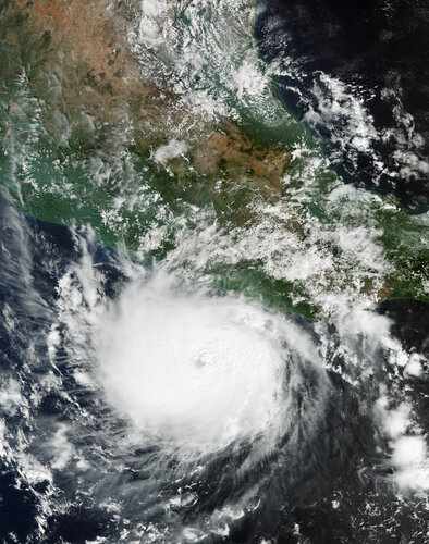 Image:
The powerful Hurricane Otis has been captured in this Copernicus Sentinel-3 image when it was approaching Mexico’s southern Pacific coast in October 2023.
Image:
The powerful Hurricane Otis has been captured in this Copernicus Sentinel-3 image when it was approaching Mexico’s southern Pacific coast in October 2023.
Minding the gap on tropical forest carbon
7.12.2023 9:00
Tropical forests are clearly critical to Earth’s climate system, but understanding exactly how much carbon they absorb from the atmosphere, store and release is tricky to calculate, not least because measuring and reporting methods vary. With these measurements paramount for nations assessing the action they are taking to combat the climate crisis, new research shows how differences in estimates of carbon flux associated with human activity can be reconciled.
Tracking human emissions from space
6.12.2023 16:00The Copernicus Anthropogenic Carbon Dioxide Monitoring (CO2M) mission will be the first satellite mission to measure how much carbon dioxide is released into the atmosphere through human activity.
CO2M isn't just a mission; it's a crucial step in our commitment to understanding and mitigating climate change. It will offer unprecedented precision in monitoring carbon dioxide emissions from the combustion of fossil fuel at national and regional scales.
Its data will provide the EU with a unique and independent source of information to assess the effectiveness of policy measures and to track their impact towards decarbonising Europe ahead of the next Global Stocktake set to place in 2028.
CO2M is one of six Copernicus Sentinel Expansion missions that ESA is developing on behalf of the EU. The missions will expand the current capabilities of the Copernicus Space Component – the world’s biggest supplier of Earth observation data.
The video features interviews with Valerie Fernandez, CO2M Mission Project Manager, Yannig Durand, CO2M Payload Manager and Yasjka Meijer, CO2M Mission Scientist.
Tracking human emissions from space
6.12.2023 16:00The Copernicus Anthropogenic Carbon Dioxide Monitoring (CO2M) mission will be the first satellite mission to measure how much carbon dioxide is released into the atmosphere through human activity.
CO2M isn't just a mission; it's a crucial step in our commitment to understanding and mitigating climate change. It will offer unprecedented precision in monitoring carbon dioxide emissions from the combustion of fossil fuel at national and regional scales.
Its data will provide the EU with a unique and independent source of information to assess the effectiveness of policy measures and to track their impact towards decarbonising Europe ahead of the next Global Stocktake set to place in 2028.
The video features interviews with Valerie Fernandez, CO2M Mission Project Manager, Yannig Durand, CO2M Payload Manager and Yasjka Meijer, CO2M Mission Scientist.
Understanding climate tipping points
6.12.2023 14:30
As the planet warms, many parts of the Earth system are undergoing large-scale changes. Ice sheets are shrinking, sea levels are rising and coral reefs are dying off.
While climate records are being continuously broken, the cumulative impact of these changes could also cause fundamental parts of the Earth system to change dramatically. These ‘tipping points’ of climate change are critical thresholds in that, if exceeded, can lead to irreversible consequences.
Delve into the new CEOS Earth Observation Handbook
5.12.2023 10:15
Delve into the new CEOS Earth Observation Handbook
ESA and UNEP collaborate for a greener future
4.12.2023 11:56
In a significant step towards a more sustainable future, ESA and the United Nations Environment Programme (UNEP) have signed a Memorandum of Understanding during Earth Information Day at COP28 currently taking place in Dubai.
The memorandum signifies a commitment to harness the power of space technology and data for environmental conservation, nature and biodiversity protection and restoration.
Contract secures next step for TRUTHS climate mission
4.12.2023 11:00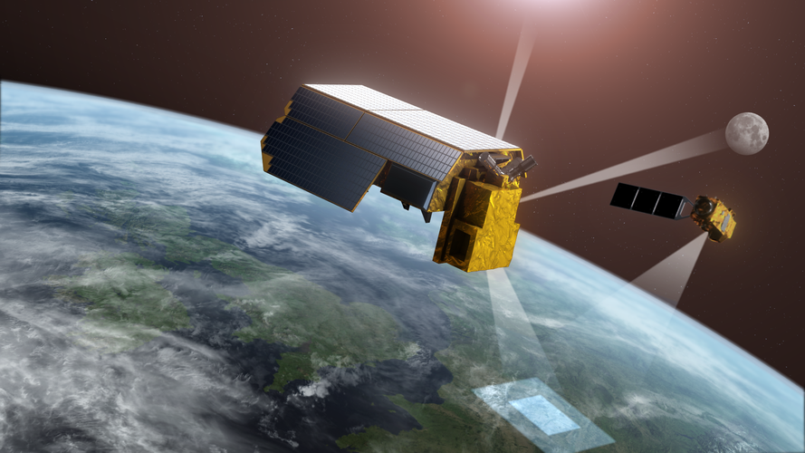
Delegates from around 200 countries are convened at the United Nations COP28 summit in Dubai to assess the action they are taking to combat the climate crisis. With satellites fundamental to understanding and monitoring climate change, ESA has awarded a contract to Airbus to take the TRUTHS satellite mission to its next development phase.
TRUTHS is set to provide the gold reference for climate measurements, thereby giving decision-makers more confidence in the data they use for climate action.
Earth from Space: American Samoa
1.12.2023 11:40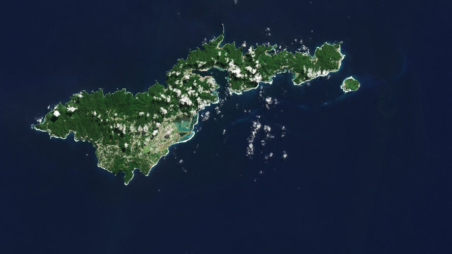 Image:
The Copernicus Sentinel-2 mission shows us an amazing view of the tropical island of Tutuila, the largest in the American Samoa archipelago in the South Pacific Ocean.
Image:
The Copernicus Sentinel-2 mission shows us an amazing view of the tropical island of Tutuila, the largest in the American Samoa archipelago in the South Pacific Ocean.
Iceberg on the loose
1.12.2023 9:00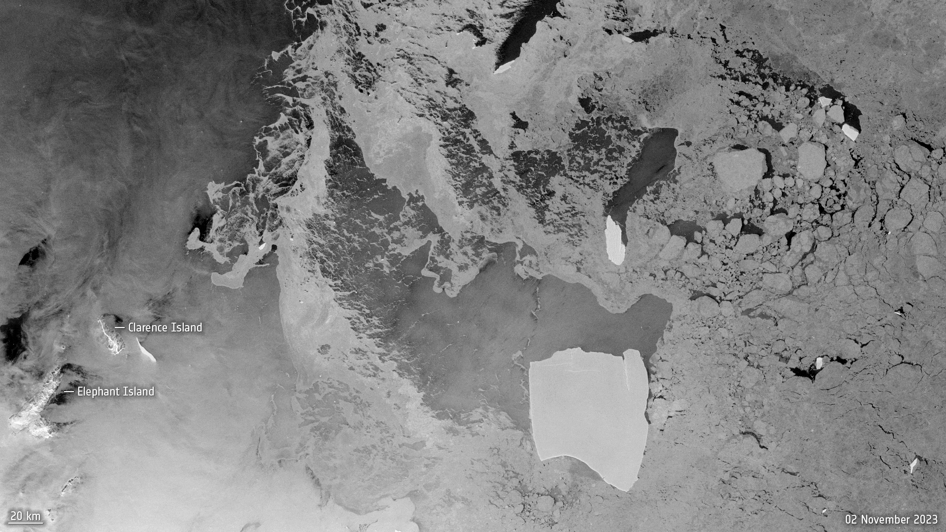 Image:
After being grounded on the ocean floor for well over four decades, the largest iceberg in the world is on the loose.
Image:
After being grounded on the ocean floor for well over four decades, the largest iceberg in the world is on the loose.
Global Stocktake: how space drives climate action
30.11.2023 17:30 Video:
00:12:34
Video:
00:12:34
Almost 200 countries are gathering in Dubai to attend the biggest climate event of the year. COP28 – the 2023 United Nations climate change summit – isn’t just another conference though. For the first time, country representatives will assess the progress they’ve made towards cutting their greenhouse gas emissions through a process called the ‘global stocktake’.
Satellites are critical in the quest to tackle climate change as they give the robustness and transparency needed to monitor progress towards a lower-emissions and more resilient world. If undertaken effectively, the global stocktake can provide an opportunity to leverage decisions and accelerate ambition in climate action plans.
This video contains interviews with ESA Director of Earth Observation Programmes, Simonetta Cheli, Antony Delavois, ESA Junior Professional, Atmospheric Composition and Yasjka Meijer, CO2M Mission Scientist.
Taking climate action with Earth observation
30.11.2023 10:10
As global temperatures records are smashed and greenhouse gas emissions reach new highs, a new report from the UN Environment Programme finds that current pledges under the Paris Agreement put the world on track for a 2.5–2.9°C temperature rise this century – pointing to the urgent need for increased climate action.
The report is timely as nearly 200 nations gather in the coming two weeks at the United Nations COP28 Climate Change Summit to conclude the world’s first ever ‘Global Stocktake’ on climate change. Swift and sustained climate action is needed to avoid the worst consequences of climate change. Satellites are critical tools in the quest to tackle climate change and monitor progress towards a lower-emissions and more resilient world.
How will EarthCARE shed light on clouds?
29.11.2023 14:18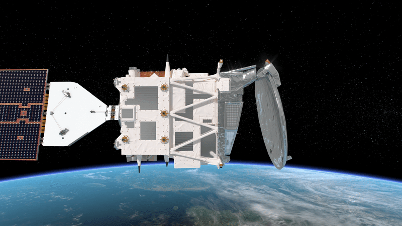
In around six months, ESA’s Earth Cloud Aerosol and Radiation Explorer mission will take to the skies to advance our understanding of the interactions between clouds, aerosols and radiation in Earth’s atmosphere. But how will it do that exactly?
The power of Earth observation
29.11.2023 10:00 Video:
00:02:07
Video:
00:02:07
We are all intricately interconnected to our Earth – from the trees that provide us with oxygen, to the natural sources that shape our landscape. ESA's Earth observation programme is at the forefront of monitoring our planet's dynamic changes. Using cutting-edge satellite technology, ESA captures invaluable data on Earth's atmosphere, land and oceans. From tracking climate patterns to assessing environmental health, ESA's Earth observation initiatives provide essential insights for scientific research, environmental management and disaster response. By harnessing space technology, ESA contributes significantly to our understanding of Earth – ensuring a sustainable future for generations to come.
Warming ocean causing rapid glacier retreat
28.11.2023 17:00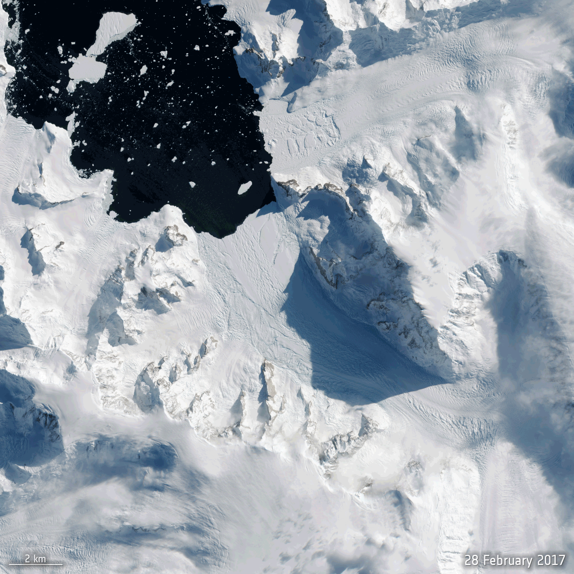
With all eyes about to focus on the COP28 climate conference in Dubai, new scientific findings show, again, that the climate crisis is taking its toll on Antarctica – a continent, up to recently, thought better able to withstand the immediate effects of rising global temperatures.
Using satellite data, scientists have discovered that the ice shelf extending into the ocean from Cadman Glacier on the west Antarctic Peninsula collapsed, leaving the glacier exposed to unusually warm ocean water, which caused the glacier to accelerate and retreat rapidly.
Earth from Space: Salty lakes
24.11.2023 10:00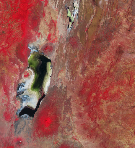 Image:
The Copernicus Sentinel-2 mission captures the colourful waters of two salty lakes in East Africa: Lake Natron in northern Tanzania and Lake Magadi in southern Kenya.
Image:
The Copernicus Sentinel-2 mission captures the colourful waters of two salty lakes in East Africa: Lake Natron in northern Tanzania and Lake Magadi in southern Kenya.
Spire joins ESA's Third Party Mission Programme
23.11.2023 11:54
Spire joins ESA's Third Party Mission Programme
Cairt and Wivern Earth Explorer candidates go forward
21.11.2023 12:52
ESA has reached a significant milestone in its commitment towards a deeper understanding of Earth's dynamic processes and addressing pressing environmental challenges with the selection of two new candidates – Cairt and Wivern – to progress to the next development phase as part of the process of realising the Agency’s eleventh Earth Explorer satellite mission.
Arctic Weather Satellite in shape
20.11.2023 15:44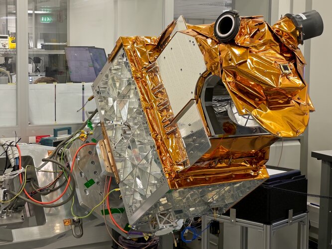
Embracing the New Space approach, it has taken just 36 months to develop and build ESA’s Arctic Weather Satellite. Now complete, this remarkable microsatellite has been shipped from OHB in Sweden to Germany where it is starting a series of tests to make sure that it will survive liftoff next year and its subsequent life in orbit.
Earth from Space: North Channel
17.11.2023 10:00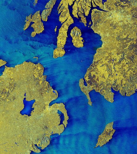 Image:
The North Channel, between Northern Ireland and Scotland, is featured in this false-colour radar image from the Copernicus Sentinel-1 mission.
Image:
The North Channel, between Northern Ireland and Scotland, is featured in this false-colour radar image from the Copernicus Sentinel-1 mission.
Italy's Mount Etna spews lava
15.11.2023 15:00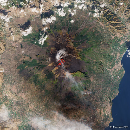 Image:
One of the world’s most active volcanoes, Mount Etna, erupted on Sunday – spewing lava and clouds of ash high over the Mediterranean island of Sicily. This image, captured on 13 November by the Copernicus Sentinel-2 mission, has been processed using the mission’s shortwave-infrared bands to show the lava flow at the time of acquisition.
Image:
One of the world’s most active volcanoes, Mount Etna, erupted on Sunday – spewing lava and clouds of ash high over the Mediterranean island of Sicily. This image, captured on 13 November by the Copernicus Sentinel-2 mission, has been processed using the mission’s shortwave-infrared bands to show the lava flow at the time of acquisition.
MetOp Second Generation weather satellite pair show off
15.11.2023 10:57
Having satellites in different types of orbit is essential to delivering data to forecast the weather accurately. With the first Meteosat Third Generation Imager satellite safely in geostationary orbit since December 2022, it’s also time to focus on its polar-orbiting cousin, the MetOp Second Generation mission. And now, for the first time, two MetOp Second Generation satellites have been brought together to stand side-by-side for testing.
Monitoring methane emissions from space
13.11.2023 13:00 Video:
00:03:23
Video:
00:03:23
Methane is the second most important greenhouse gas contributor to climate change after carbon dioxide. Curbing methane emissions could deliver immediate and long-lasting benefits for the climate, seeing as the gas only lingers in the atmosphere for a relatively short time.
Satellites have a really important role to play in reducing greenhouse gas emissions. The Tropomi instrument onboard the Copernicus Sentinel-5P satellite is the only instrument that maps global methane concentrations every single day. This lets scientists detect hotspots for large methane sources around the world – allowing us to address the consequences of methane emissions on our climate and environment.
Monitoring methane from space
13.11.2023 13:00 Video:
00:03:23
Video:
00:03:23
Methane is the second most important greenhouse gas contributor to climate change after carbon dioxide. Curbing methane emissions could deliver immediate and long-lasting benefits for the climate, seeing as the gas only lingers in the atmosphere for a relatively short time.
Satellites have a really important role to play in reducing greenhouse gas emissions. The Tropomi instrument onboard the Copernicus Sentinel-5P satellite is the only instrument that maps global methane concentrations every single day. This lets scientists detect hotspots for large methane sources around the world – allowing us to address the consequences of methane emissions on our climate and environment.
Monitoring methane emissions from space
13.11.2023 13:00 Video:
00:03:23
Video:
00:03:23
Methane is the second most important greenhouse gas contributor to climate change after carbon dioxide. Curbing methane emissions could deliver immediate and long-lasting benefits for the climate, seeing as the gas only lingers in the atmosphere for a relatively short time.
Satellites have a really important role to play in reducing greenhouse gas emissions. The Tropomi instrument onboard the Copernicus Sentinel-5P satellite is the only instrument that maps global methane concentrations every single day. This lets scientists detect hotspots for large methane sources around the world – allowing us to address the consequences of methane emissions on our climate and environment.
Two ESA Φ-lab-enabled satellites launched
13.11.2023 10:15
MANTIS, the first satellite mission to be supported from concept to liftoff by ESA’s Earth Observation InCubed programme, has been launched on a SpaceX Falcon 9 rocket. MANTIS carries a high-resolution multispectral camera coupled with a powerful AI processing unit.
Intuition-1 was also launched on the same rocket and will similarly demonstrate the advantages of onboard AI capabilities, in this case in tandem with a hyperspectral imager. The satellite’s machine learning algorithms were developed under the ESA-funded Genesis project
Two ESA Φ-lab-enabled satellites launched
13.11.2023 10:15
MANTIS, the first satellite mission to be supported from concept to liftoff by ESA’s Earth Observation InCubed programme, was launched yesterday on a SpaceX Falcon 9 rocket. MANTIS carries a high-resolution multispectral camera coupled with a powerful AI processing unit.
Intuition-1 was also launched on the same rocket and will similarly demonstrate the advantages of onboard AI capabilities, in this case in tandem with a hyperspectral imager. The satellite’s machine learning algorithms were developed under the ESA-funded Genesis project.
Two ESA Φ-lab-enabled satellites launched
13.11.2023 10:15
MANTIS, the first satellite mission to be supported from concept to liftoff by ESA’s Earth Observation InCubed programme, was launched yesterday on a SpaceX Falcon 9 rocket. MANTIS carries a high-resolution multispectral camera coupled with a powerful AI processing unit.
Intuition-1 was also launched on the same rocket and will similarly demonstrate the advantages of onboard AI capabilities, in this case in tandem with a hyperspectral imager. The satellite’s machine learning algorithms were developed under the ESA-funded Genesis project
Nourishing commercial growth in Earth observation
10.11.2023 13:17
Hot on the heels of the first Earth Observation Commercialisation Forum, now is a good time to take a look at the all-embracing support that ESA gives to the commercial sector in Europe. With funding programmes, business guidance for companies, and multiyear contracts, ESA provides a vital springboard for continued growth in commercial Earth observation.
Earth from Space: Autumn in Japan
10.11.2023 10:00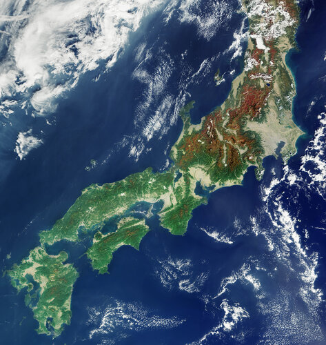 Image:
This image, from the Copernicus Sentinel-3 mission on 1 November 2023, captures the colours of autumn over the Japanese archipelago.
Image:
This image, from the Copernicus Sentinel-3 mission on 1 November 2023, captures the colours of autumn over the Japanese archipelago.
AI maps icebergs 10,000 times faster than humans
9.11.2023 9:00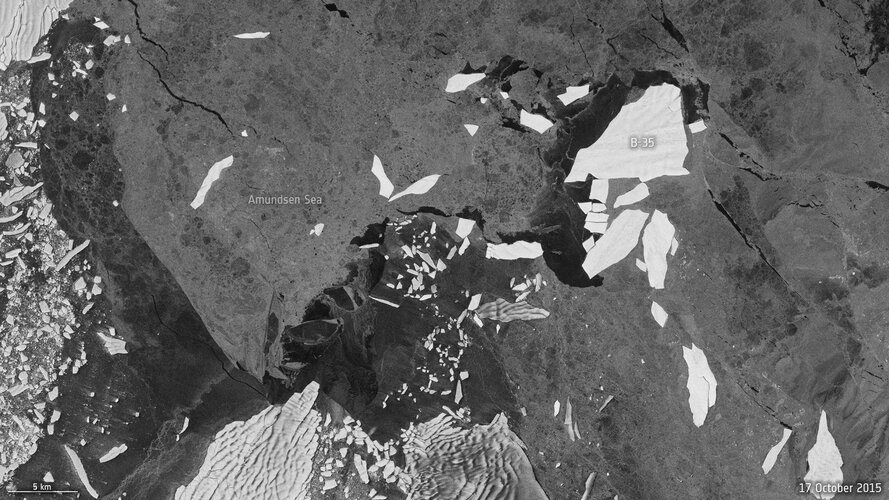
In a groundbreaking development, researchers from the University of Leeds have unveiled a neural network that can swiftly and accurately chart the expanse of large Antarctic icebergs in satellite images, accomplishing the task in a mere 0.01 seconds. This novel approach is in stark contrast to the laborious and time-consuming manual efforts needed previously.
ESA and EC to unite on climate action from space
6.11.2023 12:00
ESA and the European Commission are joining forces to accelerate the use of Earth-observing satellites and the information they provide to address the pressing challenge of climate change.
This landmark initiative signifies a firm commitment to advancing our understanding of Earth's climate system and enhancing our ability to take timely and informed actions to mitigate and adapt to the impacts of climate change, particularly encompassing the European Green Deal.
Earth from Space: Lake Maracaibo
3.11.2023 10:00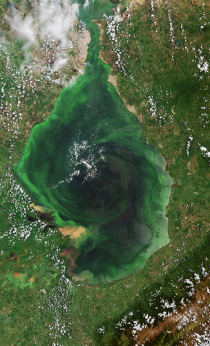 Image:
The Copernicus Sentinel-2 mission takes us over Venezuela’s Lake Maracaibo, the largest natural body of water in South America.
Image:
The Copernicus Sentinel-2 mission takes us over Venezuela’s Lake Maracaibo, the largest natural body of water in South America.
Relive the Earth Observation Commercialisation Forum
2.11.2023 13:30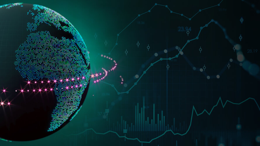
ESA’s first Earth Observation Commercialisation Forum took place at ESA Headquarters in Paris on 30–31 October 2023. The event saw investors, institutions, entrepreneurs and different-sized companies from the Earth observation sector come together to discuss the commercial potential and challenges of Earth observation. Revisit the event by watching the streaming replay.
Spooky sights from space: world’s largest acidic lake
31.10.2023 9:15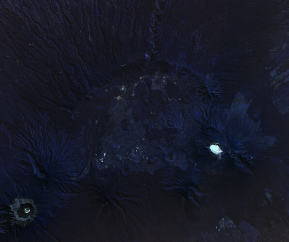 Image:
What’s spookier than the ‘largest acid cauldron on Earth?’ In East Java, Indonesia, lies the Kawah Ijen Crater Lake – the world’s largest acidic lake, a chilling spectacle perfect for Halloween.
Image:
What’s spookier than the ‘largest acid cauldron on Earth?’ In East Java, Indonesia, lies the Kawah Ijen Crater Lake – the world’s largest acidic lake, a chilling spectacle perfect for Halloween.
Watch live: ESA’s Earth Observation Commercialisation Forum
27.10.2023 13:45
ESA’s first-ever Earth Observation Commercialisation Forum will take place next week at ESA Headquarters in Paris from 30 to 31 October 2023. The event will see investors, institutions, entrepreneurs and companies of any size from the Earth observation sector coming together to discuss the commercial potential and challenges of Earth observation. Follow our live steaming on ESA WebTV Two.
Earth from Space: Elephant Island
27.10.2023 10:00 Image:
This rare, almost cloud-free view of the remote Elephant Island in Antarctica was captured in February 2023 by the Copernicus Sentinel-2 mission.
Image:
This rare, almost cloud-free view of the remote Elephant Island in Antarctica was captured in February 2023 by the Copernicus Sentinel-2 mission.
Gearing up for EarthCARE
27.10.2023 9:00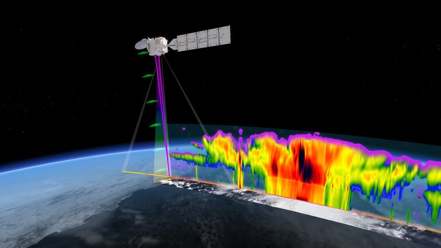
ESA and the Japanese Aerospace Exploration Agency are gearing up for a momentous milestone in Earth observation as launch of the EarthCARE satellite approaches.
Following years of rigorous development and extensive testing, the satellite is now undergoing its final round of tests in Europe before being shipped to the launch site early next year – bringing us one step closer to gaining unprecedented insights into the role that clouds and aerosols play in the climate system.
Six trends to watch in commercial Earth observation
26.10.2023 11:20
With a multitude of opportunities for start-ups, established companies and investors, commercial Earth observation is a vibrant sector with fast-moving innovations in technology, datasets and downstream applications. ESA is a key driving force for the development of European Earth observation and provides impetus through its many programmes and initiatives.
To set the scene ahead of ESA’s Earth Observation Commercialisation Forum next week, here is some need-to-know background information on the evolution and state of play of the Earth observation industry.
Earth from Space: Panama Canal
20.10.2023 10:00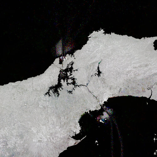 Image:
Like shining jewels in the water, ships passing through the Panama Canal, which cuts across Central America, have been captured in this Copernicus Sentinel-1 image.
Image:
Like shining jewels in the water, ships passing through the Panama Canal, which cuts across Central America, have been captured in this Copernicus Sentinel-1 image.
Copernicus operations resilience: Inuvik wildfires
19.10.2023 15:00
Copernicus operations resilience: Inuvik wildfires
Earth from Space: Bentiu, South Sudan
13.10.2023 10:00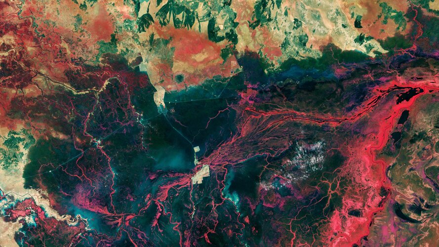 Image:
The landscape around the city of Bentiu in South Sudan is featured in this Copernicus Sentinel-2 image.
Image:
The landscape around the city of Bentiu in South Sudan is featured in this Copernicus Sentinel-2 image.
Antarctic ice shelf demise
13.10.2023 8:30
New research, based largely on information from the Copernicus Sentinel-1 and ESA’s CryoSat satellite missions, has revealed alarming findings about the state of Antarctica's ice shelves: 40% of these floating shelves have significantly reduced in volume over the past quarter-century. While this underscores the accelerating impacts of climate change on the world's southernmost continent, the picture of ice deterioration is mixed.
Measuring nutrition in crops from space
10.10.2023 13:59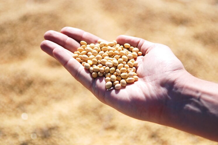
With many people around the world suffering from various forms of malnutrition it’s important that the absolute basics such as rice, soya and wheat are as nourishing as possible. ESA-funded research shows that the Copernicus Sentinel-2 mission and the Italian Prisma mission could be used to monitor the nutritional content of staple crops. This could, for example, help farmers take appropriate steps to boost the quality of their crops as they grow.
Watch: Earth Explorer 11 Consultation
9.10.2023 15:00Watch: Earth Explorer 11 Consultation
On 10-11 October, follow the discussions on the candidate missions for ESA's eleventh Earth Explorer at the User Consultation Meeting
Watch: Earth Explorer 11 Consultation
9.10.2023 15:00Watch: Earth Explorer 11 Consultation
On 10-11 October, follow the discussions on the candidate missions for ESA's eleventh Earth Explorer at the User Consultation Meeting
Earth from Space: Nueva Vizcaya, Philippines
6.10.2023 10:00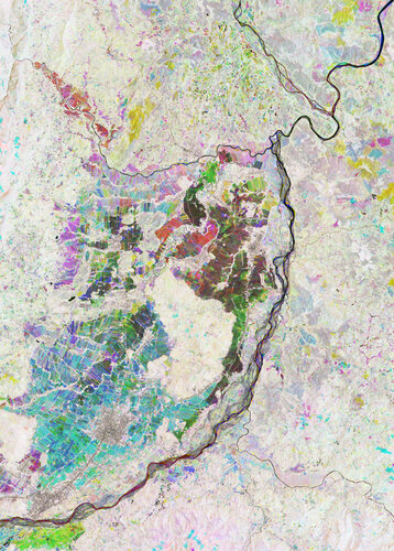 Image:
The heart of the Nueva Vizcaya Province on Luzon, the largest and most populated island of the Philippines, shows up brightly in this Copernicus Sentinel-2 false-colour image.
Image:
The heart of the Nueva Vizcaya Province on Luzon, the largest and most populated island of the Philippines, shows up brightly in this Copernicus Sentinel-2 false-colour image.
Younger trees champion carbon capture
5.10.2023 11:00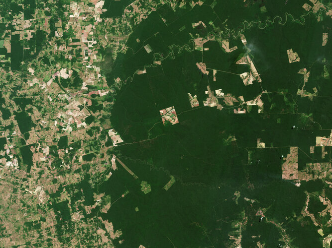
Thanks to their ability to absorb and store carbon dioxide from the atmosphere, forests have long been recognised as a key tool in the fight against climate change – but not all forests are equal. New research based on data from ESA’s SMOS satellite mission has found that, surprisingly, young trees are champions at carbon capture.
Ozone hole goes large again
4.10.2023 15:40
Measurements from the Copernicus Sentinel-5P satellite show that this year’s ozone hole over Antarctica is one of the biggest on record. The hole, which is what scientists call an ‘ozone depleting area,’ reached a size of 26 million sq km on 16 September 2023. This is roughly three times the size of Brazil.
Earth from Space: Southern Patagonian Ice Field
29.9.2023 10:00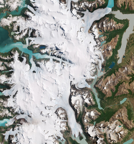 Image:
Part of the Southern Patagonian Ice Field with its white glaciers and aquamarine lakes is featured in this Copernicus Sentinel-2 image from 10 January 2023.
Image:
Part of the Southern Patagonian Ice Field with its white glaciers and aquamarine lakes is featured in this Copernicus Sentinel-2 image from 10 January 2023.
Earth from Space: Scorched Rhodes
22.9.2023 10:00 Image:
This summer, Europe experienced a relentless heatwave, fuelling wildfires in several countries. This Copernicus Sentinel-1 image shows the burn scars left by fires on the Greek island of Rhodes.
Image:
This summer, Europe experienced a relentless heatwave, fuelling wildfires in several countries. This Copernicus Sentinel-1 image shows the burn scars left by fires on the Greek island of Rhodes.
Trio of Sentinel satellites map methane super-emitters
20.9.2023 9:00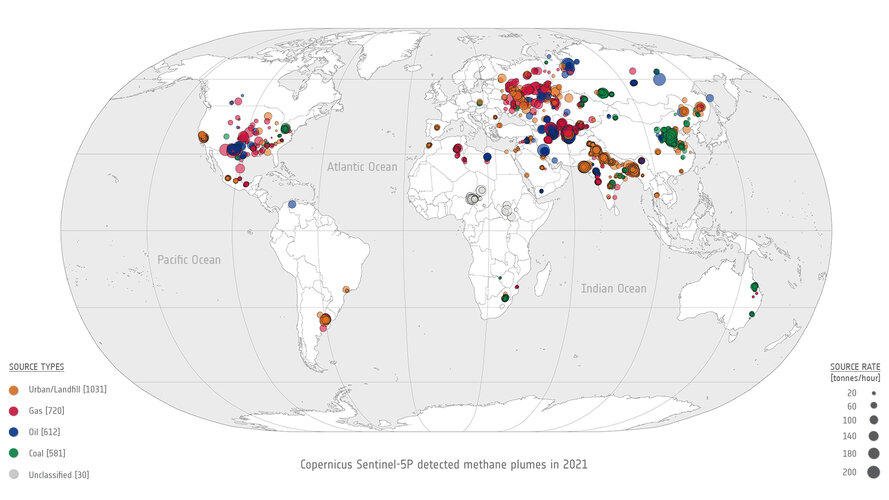
In the quest to address climate change and reduce greenhouse gas emissions, detecting methane leaks – a potent contributor to global warming – has become increasingly vital. Researchers are harnessing the capabilities of cutting-edge satellite technology to monitor these leaks from space.
Earth from Space: Blooms in the Gulf of Finland
15.9.2023 10:00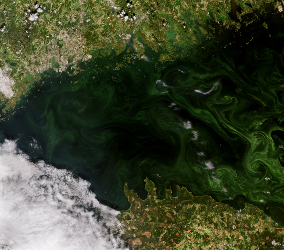 Image:
This Copernicus Sentinel-2 image features swirls of vivid, emerald green algal blooms in the Gulf of Finland.
Image:
This Copernicus Sentinel-2 image features swirls of vivid, emerald green algal blooms in the Gulf of Finland.
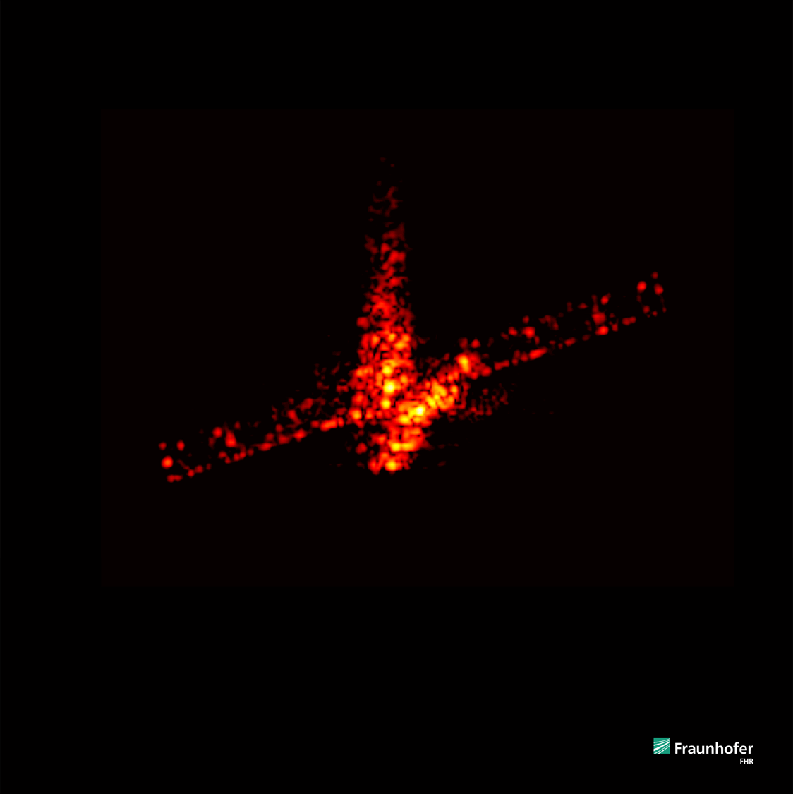
Sentinel-1 reveals shifts from Morocco earthquake
14.9.2023 13:34
Following the devastating earthquake that struck Morocco on 8 September, satellite data have been made available through the International Charter ‘Space and Major Disasters’ to help emergency response teams on the ground.
In addition, radar measurements from Europe’s Copernicus Sentinel-1 satellite mission are being used to analyse how the ground has shifted as a result of the quake, which will not only help in planning the eventual reconstruction but will also further scientific research.
Showcase your climate data visualisation talent
13.9.2023 11:00
Are you a creative visionary with a passion for climate action? Enter ESA’s latest competition to showcase your talent by transforming decades of satellite climate data into impactful visuals to help bridge the gap between climate science, policy makers and the wider public. The winner will have the unique opportunity to display their data visualisation at the 2023 United Nations Climate Change Conference (COP28) taking place later this year.
Meteosat Third Generation: painting the full picture
11.9.2023 13:00 Video:
00:00:14
Video:
00:00:14
In a significant leap forward for meteorology, the preliminary data obtained by Meteosat Third Generation’s two instruments, the Flexible Combined Imager (FCI) and the Lightning Imager (LI), were successfully combined today for the first time – highlighting their complementary capabilities. This first set of animations gives us a preview of the system’s future impact.
This animation shows the combined observations from the Meteosat Third Generation’s instruments starting at 12:00 UTC on 03 June 2023 and ending at 12:00 UTC of 04 June 2023. Lightning activity is more intense over central Africa, the northern part of South America, Europe and the Middle East.
Cloud and lightning movements are synchronised, following the global circulation patterns (east to west along the Equator, and west to east at higher latitudes). The bright sunglint area, where the Sun's light is reflected by the ocean and small water bodies towards the satellite, traverses from east to west throughout the day.
This is preliminary commissioning data, not for operational use. For more information: A forecasting revolution on its way

Sensing city night heat from space
24.8.2023 16:25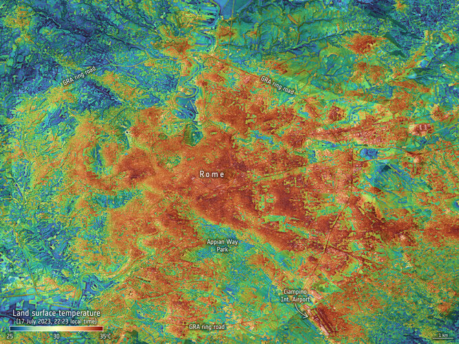
Confirmed by the World Meteorological Organization, July 2023 was the hottest month on record, with high-impact weather continuing through August. These records are based on air temperatures, but measurements of the temperature of Earth’s surface taken from space are also essential to tracking the impact of climate change, and to being better prepared for such extremes – especially when it comes to cities where stifling urban heat islands form.
Wildfires continue to rage in Greece
24.8.2023 15:07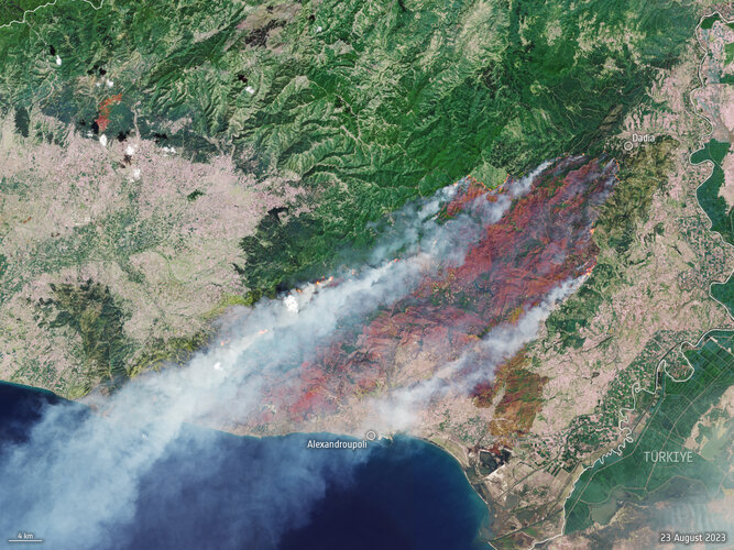 Image:
A month after fires ravaged the island of Rhodes in July 2023, more fires have ripped through Greece this week as southern Europe swelters under a late summer heatwave. This Copernicus Sentinel-2 image shows the ongoing blaze near Alexandroupoli in the Evros region of northeast Greece – close to the Türkiye border.
Image:
A month after fires ravaged the island of Rhodes in July 2023, more fires have ripped through Greece this week as southern Europe swelters under a late summer heatwave. This Copernicus Sentinel-2 image shows the ongoing blaze near Alexandroupoli in the Evros region of northeast Greece – close to the Türkiye border.
Putting the S in the first Meteosat Third Generation Sounder
14.8.2023 15:10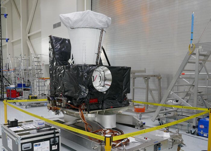
Following on from the launch of the first Meteosat Third Generation weather satellite, MTG-I1, last December, the focus is now on getting its partner satellite, MTG-S1, ready for liftoff next year – and a significant milestone has been reached. The satellite has been equipped with its main instrument, the Infrared Sounder, hence the satellite’s name, and also the Copernicus Sentinel-4 instrument, an ultraviolet, visible, near-infrared light spectrometer, or UVN for short.
Portugal blaze
8.8.2023 16:10 Image:
With Portugal in the grip of a heatwave, a wildfire broke out on 5 August south of Odemira in the Alentejo region in southern Portugal. This image, captured by the Copernicus Sentinel-2 satellite mission, shows the fire on 7 August.
Image:
With Portugal in the grip of a heatwave, a wildfire broke out on 5 August south of Odemira in the Alentejo region in southern Portugal. This image, captured by the Copernicus Sentinel-2 satellite mission, shows the fire on 7 August.
Antarctica vulnerable to extreme events
8.8.2023 10:51
According to the World Meteorological Organization, July 2023 is likely to have been the hottest month on record. While much of Europe, North America and Asia suffered the immediate consequences of these brutal temperatures, extreme events are also hitting hard far away in the icy reaches of Antarctica. In a paper published today, scientists highlight Antarctica’s vulnerability to extremes and the role that satellites play in monitoring this remote region.
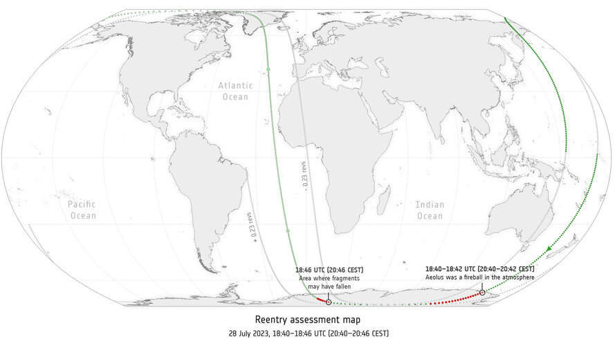 Image:
Right on track: Aeolus reentry map
Image:
Right on track: Aeolus reentry map
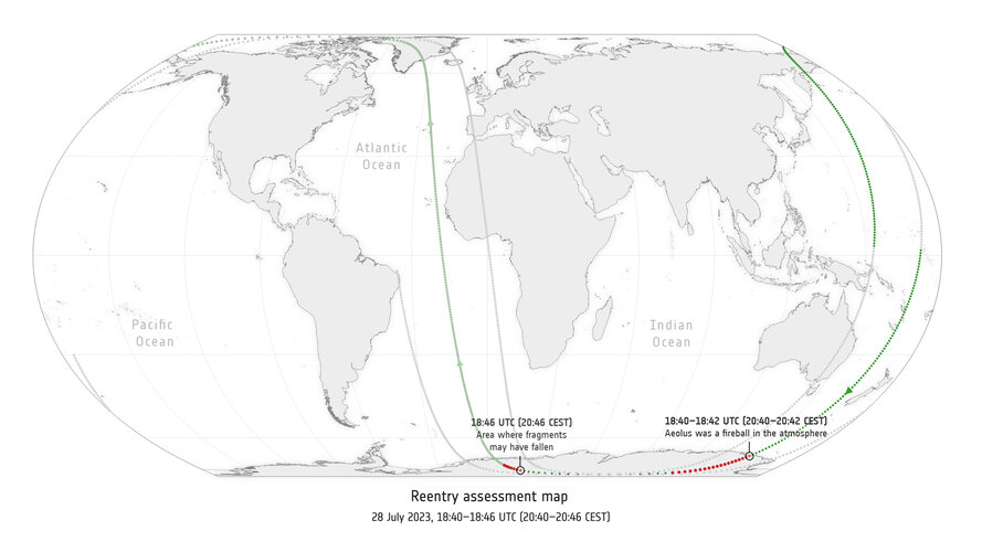 Image:
Right on track: Aeolus reentry map
Image:
Right on track: Aeolus reentry map
Counting wildfires across the globe
3.8.2023 13:50
In recent weeks, devastating wildfires have spread in Greece, Italy, Spain, Portugal, Algeria, Tunisia and Canada, causing human casualties as well as massive environmental and economic damage.
While wildfires are a natural part of many ecosystems, scientists have warned that they are becoming more frequent and more widespread. In response, an upgraded version of ESA’s World Fire Atlas is now available providing a detailed analysis of wildfires across the globe.
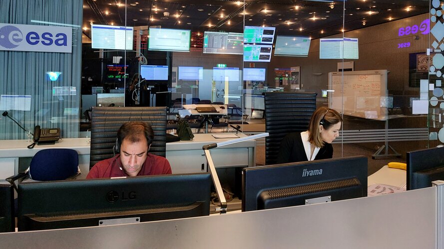
Simulating Aeolus’s demise: a bird’s eye view
3.8.2023 10:30 Video:
00:01:35
Video:
00:01:35
Aeolus’s mission is over, but weather forecasting is improved forever, and a new precedent has been set for safe satellite reentries. The trailblazing Earth Explorer returned through our atmosphere on 28 July, following the path it was guided on by ESA’s mission control over Earth’s most uninhabited regions, finally disintegrating over the Antarctic.
A week-long series of manoeuvres led to this point. They had never been performed before and pushed the satellite to its limits. Aeolus was never designed to fly at such low altitudes – its thrusters and fuel reserves were not made to operate in the thick lower reaches of Earth’s atmosphere.
Despite choppy skies and one evening where it seemed the attempt could fail, the successful reentry lowered the already small risk of surviving fragments landing where they shouldn’t.
The chance of satellite debris falling on your head is three times less than a meteorite doing the same. Despite this, as our orbital highways get busier and reentries become more common, ESA went above and beyond to lower this even further.
By turning Aeolus’s original fate – an uncontrolled, ‘natural’ reentry – into an assisted one, they reduced that risk another 42 times.
This animation shows how the final moments for Aeolus could have gone, set to a sonification of Aeolus data, composed by Jamie Perera.
Find out more about Aeolus’s final moments in the Rocket Science blog.
This simulation is created using a model of the Aeolus spacecraft, considering its shape, size, mass and materials, and the effect of 'aerothermodynamics' - the study of how high-velocity gases behave, including thermal effects between gases and solid surfaces.
The tool used, SCARAB, creates a simulation of Aeolus's reentry with ‘six degrees of freedom’, and shows the final moments of Aeolus's reentry, when the spacecraft is falling naturally in an uncontrolled descent.
Elements: FIRE
31.7.2023 15:00 Video:
00:33:08
Video:
00:33:08
English:
The summer fire season is well under way in Europe – countries all around the Mediterranean are experiencing record temperatures coupled with huge wildfires that have led to mass evacuations. In this enthralling new ESA documentary, explore how people on the frontline are using space to better monitor and fight the flames.
Follow the incredible stories of the firefighters who dealt with unprecedented fires in Gironde, France, and the forest officers using satellite data to plan for the forests’ recovery. Journey into the heart of Earth's elemental might and discover how space is changing the game for monitoring volcanic eruptions too – including one of the world’s most studied volcano, Mount Etna.
FIRE is the first episode of ESA’s new series centred around the elements and showcases how Earth observation has become crucial to those fighting climate change on the ground.
French:
La saison estivale des feux de forêts bat son plein en Europe – mais comment l’espace peut-il aider ceux qui combattent les flammes? Dans ce nouveau documentaire « FIRE » en version française, suivez les pompiers de Gironde qui ont fait face l’été dernier à des incendies sans précédent. Inspectez les arbres encore vivants dans les Landes et détectez avec les experts de l’Office National des Forêts les invasions de scolytes, petits insectes qui s’attaquent aux arbres vulnérables. Enfin, découvrez comment les satellites ont changé la donne pour observer l’activité des volcans – on vous emmène sur l’Etna !
FIRE est le premier épisode d’une nouvelle série de films de l'ESA centrée sur les éléments. La série explore la façon dont l'observation de la Terre par satellite est devenue cruciale pour tous ceux qui sont en première ligne pour gérer les crises liées au changement climatique.
German:
In diesem Sommer kam es in Ländern rund um das Mittelmeer zu Rekordtemperaturen und großen Waldbränden, die zu Massenevakuierungen führten. In dieser spannenden neuen ESA-Dokumentation erfahren Sie, wie Menschen an vorderster Front den Weltraum nutzen, um die Brände besser zu überwachen und zu bekämpfen. Verfolgen Sie die unglaublichen Geschichten der Feuerwehrleute, die letztes Jahr mit beispiellosen Bränden in der Gironde (Frankreich) zu kämpfen hatten, und der Forstbeamten, die Satellitendaten nutzten, um die Erholung der Wälder zu planen. Reisen Sie in das Herz der elementaren Macht der Erde und entdecken Sie, wie der Weltraum auch die Überwachung von Vulkanausbrüchen verändert – darunter der am besten untersuchte Vulkan der Welt, der Ätna. FEUER ist die erste Folge der neuen ESA-Serie rund um die Elemente und zeigt, wie wichtig die Erdbeobachtung aus dem All für diejenigen geworden ist, die den Klimawandel vor Ort bekämpfen.
Elements: FIRE
31.7.2023 15:00
Video:
00:33:08
English:
The summer fire season is well under way in Europe – countries all around the Mediterranean are experiencing record temperatures coupled with huge wildfires that have led to mass evacuations. In this enthralling new ESA documentary, explore how people on the frontline are using space to better monitor and fight the flames.
Follow the incredible stories of the firefighters who dealt with unprecedented fires in Gironde, France, and the forest officers using satellite data to plan for the forests’ recovery. Journey into the heart of Earth's elemental might and discover how space is changing the game for monitoring volcanic eruptions too – including one of the world’s most studied volcano, Mount Etna.
FIRE is the first episode of ESA’s new series centred around the elements and showcases how Earth observation has become crucial to those fighting climate change on the ground.
French:
La saison estivale des feux de forêts bat son plein en Europe – mais comment l’espace peut-il aider ceux qui combattent les flammes? Dans ce nouveau documentaire « FIRE » en version française, suivez les pompiers de Gironde qui ont fait face l’été dernier à des incendies sans précédent. Inspectez les arbres encore vivants dans les Landes et détectez avec les experts de l’Office National des Forêts les invasions de scolytes, petits insectes qui s’attaquent aux arbres vulnérables. Enfin, découvrez comment les satellites ont changé la donne pour observer l’activité des volcans – on vous emmène sur l’Etna !
FIRE est le premier épisode d’une nouvelle série de films de l'ESA centrée sur les éléments. La série explore la façon dont l'observation de la Terre par satellite est devenue cruciale pour tous ceux qui sont en première ligne pour gérer les crises liées au changement climatique.
German:
In diesem Sommer kam es in Ländern rund um das Mittelmeer zu Rekordtemperaturen und großen Waldbränden, die zu Massenevakuierungen führten. In dieser spannenden neuen ESA-Dokumentation erfahren Sie, wie Menschen an vorderster Front den Weltraum nutzen, um die Brände besser zu überwachen und zu bekämpfen. Verfolgen Sie die unglaublichen Geschichten der Feuerwehrleute, die letztes Jahr mit beispiellosen Bränden in der Gironde (Frankreich) zu kämpfen hatten, und der Forstbeamten, die Satellitendaten nutzten, um die Erholung der Wälder zu planen. Reisen Sie in das Herz der elementaren Macht der Erde und entdecken Sie, wie der Weltraum auch die Überwachung von Vulkanausbrüchen verändert – darunter der am besten untersuchte Vulkan der Welt, der Ätna. FEUER ist die erste Folge der neuen ESA-Serie rund um die Elemente und zeigt, wie wichtig die Erdbeobachtung aus dem All für diejenigen geworden ist, die den Klimawandel vor Ort bekämpfen.
Spanish:
En este nuevo y apasionante documental de la ESA, explora cómo las personas utilizan el espacio para monitorear y combatir mejor las llamas en primera línea. Sigue las increíbles historias de los bomberos que se ocuparon de incendios sin precedentes en Gironda, Francia, y de los agentes forestales que utilizaron datos satelitales para planificar la recuperación de los bosques. Viaja al corazón de la Tierra y descubre cómo el espacio también está cambiando las reglas del juego para monitorear las erupciones volcánicas, incluidas las de uno de los volcanes más estudiados del mundo, el Monte Etna. FIRE es el primer episodio de la nueva serie de la ESA centrada en los elementos que muestra cómo la observación de la Tierra se ha vuelto crucial para quienes luchan contra el cambio climático sobre el terreno.
Italian:
In questo nuovo avvincente documentario dell'ESA, esplora come le persone in prima linea utilizzano lo spazio per monitorare e combattere meglio le fiamme. Segui le incredibili storie dei vigili del fuoco che hanno affrontato incendi senza precedenti nella Gironda, in Francia, e delle guardie forestali che utilizzano i dati satellitari per pianificare il recupero delle foreste. Viaggia nel cuore della forza primordiale della Terra e scopri come lo spazio sta avendo un impatto anche nel monitoraggio delle eruzioni vulcaniche, incluso uno dei vulcani più studiati al mondo, l'Etna. FIRE è il primo episodio della nuova serie dell’ESA incentrata sugli elementi e mostra come l’osservazione della Terra sia diventata cruciale per coloro che combattono i cambiamenti climatici sul campo.
Elements: FIRE
31.7.2023 15:00
Video:
00:33:08
The summer fire season is well under way in Europe – countries all around the Mediterranean are experiencing record temperatures coupled with huge wildfires that have led to mass evacuations. In this enthralling new ESA documentary, explore how people on the frontline are using space to better monitor and fight the flames.
Follow the incredible stories of the firefighters who dealt with unprecedented fires in Gironde, France, and the forest officers using satellite data to plan for the forests’ recovery. Journey into the heart of Earth's elemental might and discover how space is changing the game for monitoring volcanic eruptions too – including one of the world’s most studied volcano, Mount Etna.
FIRE is the first episode of ESA’s new series centred around the elements and showcases how Earth observation has become crucial to those fighting climate change on the ground.
Elements: FIRE
31.7.2023 15:00
Video:
00:33:08
English:
The summer fire season is well under way in Europe – countries all around the Mediterranean are experiencing record temperatures coupled with huge wildfires that have led to mass evacuations. In this enthralling new ESA documentary, explore how people on the frontline are using space to better monitor and fight the flames.
Follow the incredible stories of the firefighters who dealt with unprecedented fires in Gironde, France, and the forest officers using satellite data to plan for the forests’ recovery. Journey into the heart of Earth's elemental might and discover how space is changing the game for monitoring volcanic eruptions too – including one of the world’s most studied volcano, Mount Etna.
FIRE is the first episode of ESA’s new series centred around the elements and showcases how Earth observation has become crucial to those fighting climate change on the ground.
French:
La saison estivale des feux de forêts bat son plein en Europe – mais comment l’espace peut-il aider ceux qui combattent les flammes? Dans ce nouveau documentaire « FIRE » en version française, suivez les pompiers de Gironde qui ont fait face l’été dernier à des incendies sans précédent. Inspectez les arbres encore vivants dans les Landes et détectez avec les experts de l’Office National des Forêts les invasions de scolytes, petits insectes qui s’attaquent aux arbres vulnérables. Enfin, découvrez comment les satellites ont changé la donne pour observer l’activité des volcans – on vous emmène sur l’Etna !
FIRE est le premier épisode d’une nouvelle série de films de l'ESA centrée sur les éléments. La série explore la façon dont l'observation de la Terre par satellite est devenue cruciale pour tous ceux qui sont en première ligne pour gérer les crises liées au changement climatique.
Elements: FIRE
31.7.2023 15:00
Video:
00:33:08
English:
The summer fire season is well under way in Europe – countries all around the Mediterranean are experiencing record temperatures coupled with huge wildfires that have led to mass evacuations. In this enthralling new ESA documentary, explore how people on the frontline are using space to better monitor and fight the flames.
Follow the incredible stories of the firefighters who dealt with unprecedented fires in Gironde, France, and the forest officers using satellite data to plan for the forests’ recovery. Journey into the heart of Earth's elemental might and discover how space is changing the game for monitoring volcanic eruptions too – including one of the world’s most studied volcano, Mount Etna.
FIRE is the first episode of ESA’s new series centred around the elements and showcases how Earth observation has become crucial to those fighting climate change on the ground.
French:
La saison estivale des feux de forêts bat son plein en Europe – mais comment l’espace peut-il venir en appui de tous ceux qui les combattent ? Dans cet extrait de notre nouveau documentaire « FIRE », suivez les pompiers de Gironde qui ont dû faire face à des incendies sans précédent l’année dernière.
FIRE est le premier épisode d’une nouvelle série de films de l'ESA centrée sur les éléments. La série explorera la façon dont l'observation de la Terre est devenue cruciale pour tous ceux qui sont en première ligne pour gérer les crises liées au changement climatique.
Une version française du film dans son entier sera disponible très bientôt.
Aeolus: a historic end to a trailblazing mission
29.7.2023 8:30
Surpassing scientific expectations and exceeding its planned life in orbit, the Aeolus wind mission has been hailed as one of ESA’s most successful Earth observation missions. And now, its end will go down in history too, thanks to the ingenuity of the Agency’s mission control team who guided this remarkable satellite down to Earth’s atmosphere for a safe reentry.
Earth from Space: Río de la Plata
28.7.2023 10:00 Image:
The Copernicus Sentinel-1 mission takes us over the Río de la Plata estuary between Argentina and Uruguay.
Image:
The Copernicus Sentinel-1 mission takes us over the Río de la Plata estuary between Argentina and Uruguay.
Aeolus reentry - LIVE
27.7.2023 11:10
Aeolus reentry - LIVE
Get rolling updates on the Aeolus reentry, on the Rocket Science blog
Historic Aeolus reentry – how it happened
27.7.2023 11:10
Historic Aeolus reentry – how it happened
Get rolling updates on the Aeolus reentry, on the Rocket Science blog
Aeolus reentry: the breakdown
26.7.2023 15:20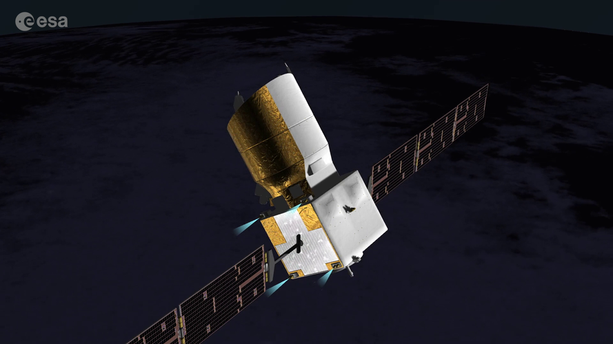 Video:
00:02:42
Video:
00:02:42
After a remarkable life in orbit, Aeolus is out of fuel and out of time – it’s returning to Earth this week. Planned and built before any regulations were put in place on ‘end-of-life’ disposal, the Earth Explorer was designed to naturally return through our atmosphere.
After months of detailed planning and analysis, ESA together with industrial partners has designed a complex and never-before-performed set of manoeuvres to control, as much as possible, Aeolus’ fall.
The assisted reentry attempt is built on four main phases, now begun at ESA’s mission control:
- Phase I: once Aeolus has fallen naturally to 280 km, the first manoeuvre is performed – the largest in the mission’s five years in orbit. The main objectives are to lower the satellite down to 250 km and to check how the satellite behaves when executing a large manoeuvre at such low altitudes – more than three times the size of any performed during routine operations.
- Phase II: after three to five days, a series of four manoeuvres will lower Aeolus’s ‘perigee altitude’ – the point in orbit closest to Earth – down to an altitude of about 150 km.
- Phase III: a final manoeuvre will lower Aeolus to a perigee altitude of 120 km.
- Phase IV: in the final, shortest phase, Aeolus the spacecraft becomes space debris, completing its final descent in just a few Earth revolutions.
In this animation, round regions temporarily lit up in bright green show the moments that Aeolus is in contact with antennas on Earth. It is in these periods that mission control is in touch with the satellite and can send up commands and get its data down.
Aeolus is repeatedly turned, or ‘slewed’ by 180° in order to switch from the routine orientation (or ‘attitude’), in which the satellite’s ‘X-band’ antenna points toward Earth and the GPS can function to track the mission – crucial to maintaining knowledge of its position – and the ‘retrograde’ attitude.
This second, ‘upside down’ position is necessary for the thrusters to fire in the opposite direction to Aeolus’s flight direction, causing it to lose energy and lower in orbit.
While the ultimate goal is for the spacecraft to burn up as it reenters through the atmosphere, teams need to keep it functioning long enough that they can continue to send up commands and control it on its path.
After the final commands are sent, Aeolus will be ‘passivated’. Passivation is when any energy onboard a spacecraft is removed, for example, its propellant or batteries. Doing this prevents explosions and fragmentation events, that could cause the release of lots of pieces of unwanted space debris.
For Aeolus, already out of fuel, it will simply be turned off. After this point, teams at mission control will continue to monitor the situation until Aeolus’s ultimate reentry location is confirmed.
For rolling updates on Aeolus's reentry, follow ‘Aeolus reentry: live’ on the Rocket Science blog.
Credits: ESA - Montserrat Piñol Solé
Music: Yesterday’s Hero by Steve Rothery, published by Tunecore. Used with permission of Steve Rothery.
Litli-Hrútur eruption seen from space
26.7.2023 12:00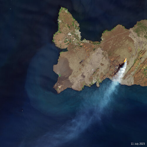
On 10 July 2023, a volcano some 30 km from Iceland’s capital, Reykjavik, erupted following heightened seismic activity in the area. Satellites orbiting above us have captured the molten lava and smoke plume puffing from the Litli-Hrútur volcano.
Satellites unveil the far-reaching impact of irrigation
25.7.2023 10:30
Globally, more than 70% of the freshwater withdrawn from Earth’s surface or from underground is used to irrigate crops. The need to produce more food for a growing population against the backdrop of climate change is challenging enough, but satellites reveal that extracting water doesn’t just affect the local environment – there are knock-on consequences for many aspects of the Earth system.
Rhodes wildfire forces thousands to flee
24.7.2023 14:58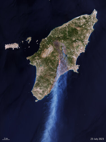 Image:
Rhodes wildfire forces thousands to flee
Image:
Rhodes wildfire forces thousands to flee
Journey back to Earth: Aeolus' historic reentry
21.7.2023 15:00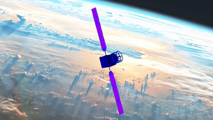 Video:
00:05:00
Video:
00:05:00
ESA’s wind mission Aeolus is coming home. After five years of improving weather forecasts, the satellite will return in a first-of-its-kind assisted reentry. At ESA’s Space Operations Centre in Germany, mission control will use the satellite’s remaining fuel to steer Aeolus during its return to Earth.
Find out more about the mission, its successes and how Aeolus is paving the way for safe reentries.
Earth from Space: New York
21.7.2023 10:00 Image:
This Copernicus Sentinel-2 image highlights the colours of autumn over the southern part of New York state in the US.
Image:
This Copernicus Sentinel-2 image highlights the colours of autumn over the southern part of New York state in the US.
Satellites map aftermath of Emilia-Romagna floods
20.7.2023 14:55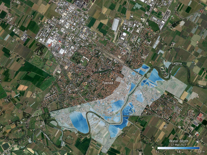
The Italian region of Emilia-Romagna was devastated by severe floods in May 2023, claiming lives and displacing thousands of people, resulting in an estimated €8.8 billion in damages. With the region still grappling with the aftermath, satellites have been instrumental in assessing the damages of the affected areas.
Replay: Aeolus reentry media briefing
19.7.2023 14:00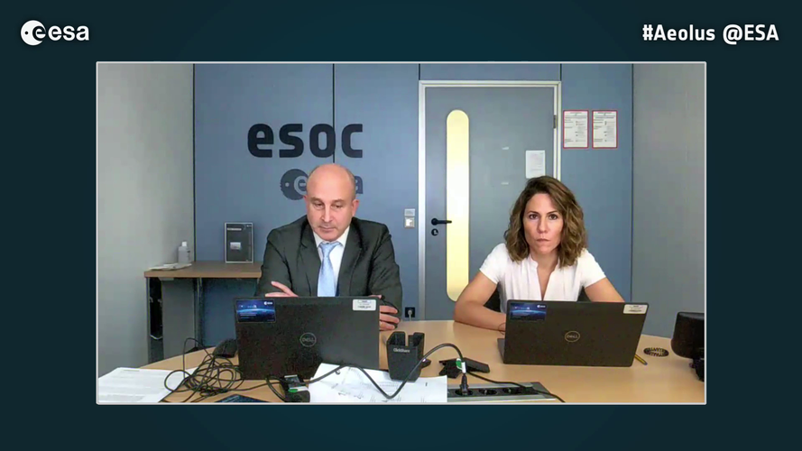 Video:
00:45:00
Video:
00:45:00
After completing its mission in orbit, ESA’s wind mission Aeolus will soon reenter Earth's atmosphere. Currently orbiting 320 km above, Aeolus is being kept in orbit with its remaining fuel. This fuel is running out, and the satellite will soon succumb to Earth’s atmosphere and gravity.
Going above and beyond what the satellite was technically designed to do, ESA is attempting a first-of-its-kind assisted reentry to reduce the (already very small) risk of damage from any fragments that survive the journey and reach the ground.
ESA held an online media briefing on 19 July 2023 to explain more about this assisted approach and answer questions.
Replay: Aeolus reentry media briefing
19.7.2023 14:00
Video:
00:40:24
After completing its mission in orbit, ESA’s wind mission Aeolus will soon reenter Earth's atmosphere. Currently orbiting 320 km above, Aeolus is being kept in orbit with its remaining fuel. This fuel is running out, and the satellite will soon succumb to Earth’s atmosphere and gravity.
Going above and beyond what the satellite was technically designed to do, ESA is attempting a first-of-its-kind assisted reentry to reduce the (already very small) risk of damage from any fragments that survive the journey and reach the ground.
ESA held an online media briefing on 19 July 2023 to explain more about this assisted approach and answer questions.
New strategy to keep pace with our changing world
18.7.2023 12:03
Fuelled largely by climate change, our planet is being subjected to environmental changes that are having an unprecedented global impact on humans, animals and plants. Shockingly, in certain locations these changes are occurring at a rate never before witnessed.
To keep pace with the challenges we face, ESA is embarking on a new Earth observation science strategy – and has reached out to the scientific community at this early stage in the process to help guide the Agency’s scientific agenda for the coming years.