


![]()

ESA Observing the Earth 
zdroje zpráv:
Picturing permafrost in the Arctic
25.2.2020 16:27
Permafrost plays an important role in the global climate and is also one of the components of the Earth system that is most sensitive to global warming. Maps, produced by ESA’s Climate Change Initiative, are providing new insights into thawing permafrost in the Arctic.
Earth from Space: Houston, Texas
21.2.2020 10:00 Video:
00:02:55
Video:
00:02:55
In this week's edition of the Earth from Space programme, the Copernicus Sentinel-1 mission takes us over Houston, the most populous city in Texas and the fourth largest in the US.
See also Houston, Texas to download the image.
In this week's edition of the Earth from Space programme, the Copernicus Sentinel-1 mission takes us over Houston, the most populous city in Texas and the fourth largest in the US.
See also Houston, Texas to download the image.
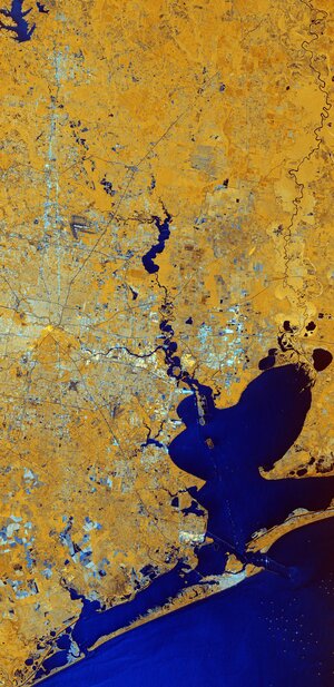 Image:
Houston, Texas
Image:
Houston, Texas
Earth from Space: Houston, Texas
21.2.2020 10:00
Video:
00:02:55
In this week's edition of the Earth from Space programme, the Copernicus Sentinel-1 mission takes us over Houston, the most populous city in Texas and the fourth largest in the US.
See also Houston, Texas to download the image.
Bolivian highland heart
14.2.2020 10:00 Image:
For Valentine’s Day, we bring you this Copernicus Sentinel-2 image capturing a beautiful heart-shaped geographical formation in the dramatic landscape of the southern highlands of Bolivia.
The highlands are part of the Altiplano, meaning High Plateau, a region that stretches almost 1000 km from Peru to Bolivia. The landscape consists of a series of basins lying about 3500 m above sea level and is the most extensive area of high plateau on Earth, outside Tibet.
This particular area featured here is a transition between the desert in the west and the tropical forest in the east. The heart-shaped formation has been moulded by many layers of different geological formations over time. The many streams and rivers visible in this image have also contributed to the shaping of the landscape as we see it today.
This false-colour composite image was processed by selecting spectral bands that can be used for classifying geological features – but here the image processing also highlights this lovely heart for today’s image.
Sucre, the capital of the Chuquisaca Department, is visible at the top of the image in grey. Designated a UNESCO World Heritage Site, the city lies at an elevation of around 2800 metres above sea level. To the left of Sucre, the Maragua crater can be seen – a popular hiking destination.
Satellites, such as Copernicus Sentinel-2, allow us to capture beautiful images such as these from space, but also to monitor changing places on Earth. Flying 800 km above, satellites take the pulse of our planet by systematically imaging and measuring changes taking place, which is particularly important in regions that are otherwise difficult to access. This allows for informed decisions to be made to help protect our world for future generations and for all citizens that inhabit our beloved Earth.
We send all our love for Valentine’s Day from the high plateaus of Bolivia – and hope we continue our celebration of love for Earth every day of the year.
This image, which was captured on 26 January 2020, is also featured on the Earth from Space video programme.
Earth from space: Bolivian highland heart
14.2.2020 10:00 Video:
00:00:00
Video:
00:00:00
For Valentine's Day, this week's edition of the Earth from Space programme features a Copernicus Sentinel-2 image, capturing a beautiful heart-shaped geographical formation in the dramatic landscape of the southern highlands of Bolivia.
See also Bolivian highland heart to download the image.
Earth from space: Bolivian highland heart
14.2.2020 10:00
Video:
00:00:00
For Valentine's Day, this week's edition of the Earth from Space programme features a Copernicus Sentinel-2 image, capturing a beautiful heart-shaped geographical formation in the dramatic landscape of the southern highlands of Bolivia.
See also Bolivian highland heart to download the image.
For Valentine's Day, this week's edition of the Earth from Space programme features a Copernicus Sentinel-2 image, capturing a beautiful heart-shaped geographical formation in the dramatic landscape of the southern highlands of Bolivia.
See also Bolivian highland heart to download the image.
Earth from space: Bolivian highland heart
12.2.2020 17:44
Video:
00:00:00
For Valentine's Day, this week's edition of the Earth from Space programme features a Copernicus Sentinel-2 image, capturing a beautiful heart-shaped geographical formation in the dramatic landscape of the southern highlands of Bolivia.
See also Bolivian highland heart to download the image.
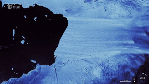
Iceberg shattered
12.2.2020 14:10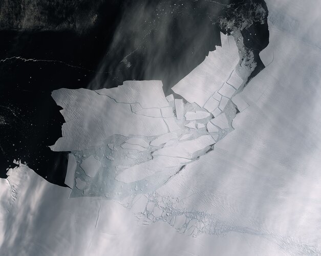 Image:
The Pine Island Glacier recently spawned an iceberg over 300 sq km that very quickly shattered into pieces. This almost cloud-free image, captured on 11 February by the Copernicus Sentinel-2 mission, shows the freshly broken bergs in detail.
A recent animation using 57 radar images captured by the Copernicus Sentinel-1 mission shows just how quickly the emerging cracks from the glacier grew – leading to this historic calving event.
Thanks to the combination of both optical and radar images from the Copernicus Sentinel satellite missions, growing cracks were spotted in the Pine Island Glacier last year, and since then, scientists have been keeping a close eye on how quick the cracks were growing.
The Pine Island Glacier, along with its neighbour Thwaites glacier, connect the centre of the West Antarctic Ice Sheet with the ocean, and together discharge significant quantities of ice into the ocean.
Iceberg shattered
12.2.2020 14:10
Image:
The Pine Island Glacier recently spawned an iceberg over 300 sq km that very quickly shattered into pieces. This almost cloud-free image, captured on 11 February by the Copernicus Sentinel-2 mission, shows the freshly broken bergs in detail.
A recent animation using 57 radar images captured by the Copernicus Sentinel-1 mission shows just how quickly the emerging cracks from the glacier grew – leading to this historic calving event.
Thanks to the combination of both optical and radar images from the Copernicus Sentinel satellite missions, growing cracks were spotted in the Pine Island Glacier last year, and since then, scientists have been keeping a close eye on how quick the cracks were growing.
The Pine Island Glacier, along with its neighbour Thwaites glacier, connect the centre of the West Antarctic Ice Sheet with the ocean, and together discharge significant quantities of ice into the ocean.
Pine Island Glacier spawns piglets
11.2.2020 10:27 Video:
00:00:11
Video:
00:00:11
As anticipated, Pine Island Glacier, known as PIG for short, in Antarctica has just spawned a huge iceberg. At over 300 sq km, about the size of Malta, this huge berg very quickly broke into many ‘piglet’ pieces the largest of which is dubbed B-49. Thanks to images from the Copernicus Sentinel satellite missions, two large rifts in the glacier were spotted last year and scientists have been keeping a close eye on how quickly these cracks were growing. This animation uses 57 radar images captured by the Copernicus Sentinel-1 mission between February 2019 and February 2020 (the last frame is from 10 February 2020) and shows just how quickly the emerging cracks grew and led to this calving event.
Pine Island Glacier, along with its neighbour Thwaites Glacier, connect the centre of the West Antarctic Ice Sheet with the ocean – together discharging significant quantities of ice into the ocean. These two glaciers have been losing ice over the last 25 years. Owing to their extremely remote location, satellites play a critical role in measuring and monitoring Antarctic glaciology – revealing the timing and pace of glacial retreat in Antarctica. Since the early 1990s, the Pine Island Glacier’s ice velocity has increased dramatically to values which exceed 10 m a day. Its floating ice front, which has an average thickness of approximately 500 metres, has experienced a series of calving events over the past 30 years, some of which have abruptly changed the shape and position of the ice front.
These changes have been mapped by ESA-built satellites since the 1990s, with calving events occurring in 1992, 1995, 2001, 2007, 2013, 2015, 2017, 2018, and now 2020.
Mark Drinkwater, senior scientist and cryosphere specialist remarked, “The Copernicus twin Sentinel-1 all-weather satellites have established a porthole through which the public can watch events like this unfold in remote regions around the world. What is unsettling is that the daily data stream reveals the dramatic pace at which climate is redefining the face of Antarctica.”
Get the animated gif here.
The Copernicus Sentinel-2 image can be found here.
Pine Island Glacier spawns piglets
11.2.2020 10:27
Video:
00:00:11
As anticipated, Pine Island Glacier, known as PIG for short, in Antarctica has just spawned a huge iceberg. At over 300 sq km, about the size of Malta, this huge berg very quickly broke into many ‘piglet’ pieces the largest of which is dubbed B-49. Thanks to images from the Copernicus Sentinel satellite missions, two large rifts in the glacier were spotted last year and scientists have been keeping a close eye on how quickly these cracks were growing. This animation uses 57 radar images captured by the Copernicus Sentinel-1 mission between February 2019 and February 2020 (the last frame is from 10 February 2020) and shows just how quickly the emerging cracks grew and led to this calving event.
Pine Island Glacier, along with its neighbour Thwaites Glacier, connect the centre of the West Antarctic Ice Sheet with the ocean – together discharging significant quantities of ice into the ocean. These two glaciers have been losing ice over the last 25 years. Owing to their extremely remote location, satellites play a critical role in measuring and monitoring Antarctic glaciology – revealing the timing and pace of glacial retreat in Antarctica. Since the early 1990s, the Pine Island Glacier’s ice velocity has increased dramatically to values which exceed 10 m a day. Its floating ice front, which has an average thickness of approximately 500 metres, has experienced a series of calving events over the past 30 years, some of which have abruptly changed the shape and position of the ice front.
These changes have been mapped by ESA-built satellites since the 1990s, with calving events occurring in 1992, 1995, 2001, 2007, 2013, 2015, 2017, 2018, and now 2020.
Mark Drinkwater, senior scientist and cryosphere specialist remarked, “The Copernicus twin Sentinel-1 all-weather satellites have established a porthole through which the public can watch events like this unfold in remote regions around the world. What is unsettling is that the daily data stream reveals the dramatic pace at which climate is redefining the face of Antarctica.”
Get the animated gif here.
The Copernicus Sentinel-2 image can be found here.
Pine Island Glacier spawns piglets
11.2.2020 10:27
Video:
00:00:11
As anticipated, Pine Island Glacier, known as PIG for short, in Antarctica has just spawned a huge iceberg. At over 300 sq km, about the size of Malta, this huge berg very quickly broke into many ‘piglet’ pieces the largest of which is dubbed B-49. Thanks to images the Copernicus Sentinel satellite missions, two large rifts in the glacier were spotted last year and scientists have been keeping a close eye on how quickly these cracks were growing. This animation uses 57 radar images captured by the Copernicus Sentinel-1 mission between February 2019 and February 2020 (the last frame is from today, 11 February 2020) and shows just how quickly the emerging cracks grew and led to this calving event.
Pine Island Glacier, along with its neighbour Thwaites Glacier, connect the centre of the West Antarctic Ice Sheet with the ocean – together discharging significant quantities of ice into the ocean. These two glaciers have been losing ice over the last 25 years. Owing to their extremely remote location, satellites play a critical role in measuring and monitoring Antarctic glaciology – revealing the timing and pace of glacial retreat in Antarctica. Since the early 1990s, the Pine Island Glacier’s ice velocity has increased dramatically to values which exceed 10 m a day. Its floating ice front, which has an average thickness of approximately 500 metres, has experienced a series of calving events over the past 30 years, some of which have abruptly changed the shape and position of the ice front.
These changes have been mapped by ESA-built satellites since the 1990s, with calving events occurring in 1992, 1995, 2001, 2007, 2011, 2013, 2015, 2017, 2018, and now 2020.
Mark Drinkwater, senior scientist and cryosphere specialist remarked, “The Copernicus twin Sentinel-1 all-weather satellites have established a porthole through which the public can watch events like this unfold in remote regions around the world. What is unsettling is that the daily data stream reveals the dramatic pace at which climate is redefining the face of Antarctica.”
Pine Island Glacier spawns piglets
11.2.2020 10:27
Video:
00:00:11
As anticipated, Pine Island Glacier, known as PIG for short, in Antarctica has just spawned a huge iceberg. At over 300 sq km, about the size of Malta, this huge berg very quickly broke into many ‘piglet’ pieces the largest of which is dubbed B-49. Thanks to images from the Copernicus Sentinel satellite missions, two large rifts in the glacier were spotted last year and scientists have been keeping a close eye on how quickly these cracks were growing. This animation uses 57 radar images captured by the Copernicus Sentinel-1 mission between February 2019 and February 2020 (the last frame is from today, 11 February 2020) and shows just how quickly the emerging cracks grew and led to this calving event.
Pine Island Glacier, along with its neighbour Thwaites Glacier, connect the centre of the West Antarctic Ice Sheet with the ocean – together discharging significant quantities of ice into the ocean. These two glaciers have been losing ice over the last 25 years. Owing to their extremely remote location, satellites play a critical role in measuring and monitoring Antarctic glaciology – revealing the timing and pace of glacial retreat in Antarctica. Since the early 1990s, the Pine Island Glacier’s ice velocity has increased dramatically to values which exceed 10 m a day. Its floating ice front, which has an average thickness of approximately 500 metres, has experienced a series of calving events over the past 30 years, some of which have abruptly changed the shape and position of the ice front.
These changes have been mapped by ESA-built satellites since the 1990s, with calving events occurring in 1992, 1995, 2001, 2007, 2011, 2013, 2015, 2017, 2018, and now 2020.
Mark Drinkwater, senior scientist and cryosphere specialist remarked, “The Copernicus twin Sentinel-1 all-weather satellites have established a porthole through which the public can watch events like this unfold in remote regions around the world. What is unsettling is that the daily data stream reveals the dramatic pace at which climate is redefining the face of Antarctica.”
Pine Island Glacier spawns piglets
11.2.2020 10:27
Video:
00:00:11
As anticipated, Pine Island Glacier, known as PIG for short, in Antarctica has just spawned a huge iceberg. At over 300 sq km, about the size of Malta, this huge berg very quickly broke into many ‘piglet’ pieces the largest of which is dubbed B-49. Thanks to images from the Copernicus Sentinel satellite missions, two large rifts in the glacier were spotted last year and scientists have been keeping a close eye on how quickly these cracks were growing. This animation uses 57 radar images captured by the Copernicus Sentinel-1 mission between February 2019 and February 2020 (the last frame is from 10 February 2020) and shows just how quickly the emerging cracks grew and led to this calving event.
Pine Island Glacier, along with its neighbour Thwaites Glacier, connect the centre of the West Antarctic Ice Sheet with the ocean – together discharging significant quantities of ice into the ocean. These two glaciers have been losing ice over the last 25 years. Owing to their extremely remote location, satellites play a critical role in measuring and monitoring Antarctic glaciology – revealing the timing and pace of glacial retreat in Antarctica. Since the early 1990s, the Pine Island Glacier’s ice velocity has increased dramatically to values which exceed 10 m a day. Its floating ice front, which has an average thickness of approximately 500 metres, has experienced a series of calving events over the past 30 years, some of which have abruptly changed the shape and position of the ice front.
These changes have been mapped by ESA-built satellites since the 1990s, with calving events occurring in 1992, 1995, 2001, 2007, 2013, 2015, 2017, 2018, and now 2020.
Mark Drinkwater, senior scientist and cryosphere specialist remarked, “The Copernicus twin Sentinel-1 all-weather satellites have established a porthole through which the public can watch events like this unfold in remote regions around the world. What is unsettling is that the daily data stream reveals the dramatic pace at which climate is redefining the face of Antarctica.”
Get the animated gif here.
Earth from Space: Flevoland
7.2.2020 10:00 Video:
00:03:01
Video:
00:03:01
In this week's edition of the Earth from Space programme, the Copernicus Sentinel-1 mission takes us over part of the Dutch province of Flevoland – the newest province in the Netherlands and one of the largest land reclamation projects in the world.
See also Flevoland, the Netherlands to download the image.
Flevoland, the Netherlands
7.2.2020 10:00 Image:
The Copernicus Sentinel-1 mission takes us over part of the Dutch province of Flevoland – the newest province in the Netherlands and one of the largest land reclamation projects in the world.
With almost a third of the country lying below sea level, the Netherlands is famously known as a ‘low country,’ and has a long history of land reclamation.
One reclamation project resulted in Flevoland. After a major flood it was decided to tame the Zuiderzee, a large, shallow inlet of the North Sea, to improve flood protection and also create additional land for agricultural use.
The project entailed the creation of land known as polders. The ‘Noordoostpolder,’ or the Northeast polder is the focus of this image. Over the years, the region has developed to become a home to a modern and innovative agricultural industry. The province produces predominantly apples, cereals, potatoes and flowers – with each colourful patch in the image representing a different crop.
This image combines three radar acquisitions from the Copernicus Sentinel-1 mission taken about two months apart to show change in crop and land conditions over time. The first image from 8 May 2018 is associated with red, the second from 7 July depicts changes in green, and the third from 5 September has been linked to blue.
Along the dikes of the Ijsselmeer, west of the Noordoostpolder, lies one of the largest wind farms in the Netherlands. The strong, almost star-shaped, reflections that can be seen near the shore are around 86 wind turbines. The wind farm is said to generate approximately 1.4 billion kWh of clean renewable energy per year – comparable to the power consumption of over 400 000 households.
Images acquired with radar are interpreted by studying the intensity of the backscatter radar signal, which is related to the roughness of the ground. Cities and towns are visible in white owing to the stronger reflection of the signal. Emmeloord can be seen in the centre of the Noordoostpolder, as well as several farms that appear as bright white dots along the roads.
This image is also featured on the Earth from Space video programme.
Flevoland, the Netherlands
7.2.2020 10:00
Image:
The Copernicus Sentinel-1 mission takes us over part of the Dutch province of Flevoland – the newest province in the Netherlands and one of the largest land reclamation projects in the world.
With almost a third of the country lying below sea level, the Netherlands is famously known as a ‘low country,’ and has a long history of land reclamation.
One reclamation project resulted in Flevoland. After a major flood it was decided to tame the Zuiderzee, a large, shallow inlet of the North Sea, to improve flood protection and also create additional land for agricultural use.
The project entailed the creation of land known as polders. The ‘Noordoostpolder,’ or the Northeast polder is the focus of this image. Over the years, the region has developed to become a home to a modern and innovative agricultural industry. The province produces predominantly apples, cereals, potatoes and flowers – with each colourful patch in the image representing a different crop.
This image combines three radar acquisitions from the Copernicus Sentinel-1 mission taken about two months apart to show change in crop and land conditions over time. The first image from 8 May 2018 is associated with blue, the second from 7 July depicts changes in green, and the third from 5 September has been linked to red.
Along the dikes of the Ijsselmeer, west of the Noordoostpolder, lies one of the largest wind farms in the Netherlands. The strong, almost star-shaped, reflections that can be seen near the shore are around 86 wind turbines. The wind farm is said to generate approximately 1.4 billion kWh of clean renewable energy per year – comparable to the power consumption of over 400 000 households.
Images acquired with radar are interpreted by studying the intensity of the backscatter radar signal, which is related to the roughness of the ground. Cities and towns are visible in white owing to the stronger reflection of the signal. Emmeloord can be seen in the centre of the Noordoostpolder, as well as several farms that appear as bright white dots along the roads.
This image is also featured on the Earth from Space video programme.
Earth from Space: Flevoland
7.2.2020 10:00
Video:
00:03:01
In this week's edition of the Earth from Space programme, the Copernicus Sentinel-1 mission takes us over part of the Dutch province of Flevoland – the newest province in the Netherlands and one of the largest land reclamation projects in the world.
See also Flevoland, the Netherlands to download the image.
Space key to wetland conservation
5.2.2020 9:00
Wetlands worldwide are vanishing at an alarming rate. New maps produced by ESA’s GlobWetland Africa project show how satellite observations can be used for the effective use and management of wetlands in Africa.
Earth from Space: Lake George
31.1.2020 10:00 Video:
00:03:07
Video:
00:03:07
Ahead of World Wetlands Day, celebrated internationally each year on 2 February, this week's edition of the Earth from Space programme features a Copernicus Sentinel-2 image over Lake George in western Uganda. In 1988, Lake George was designated as Uganda’s first site under the Ramsar Convention - an international treaty for the conservation and sustainable use of wetlands.
See also Lake George, Uganda to download the image.
Lake George, Uganda
31.1.2020 10:00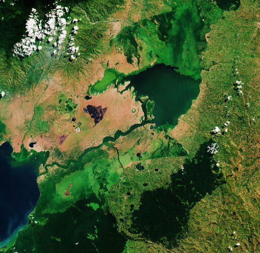 Image:
World Wetlands Day is celebrated internationally each year on 2 February. It marks the anniversary of the signing of the Convention on Wetlands of International Importance, known as the Ramsar Convention, in Ramsar, Iran, on 2 February 1971.
World Wetlands Day raises global awareness about the vital role of wetlands for our planet, paying particular attention to wetland biodiversity.
This Copernicus Sentinel-2 image takes us over Lake George, in western Uganda. In 1988, Lake George was designated as Uganda’s first Ramsar site, given its importance as a centre for biological diversity.
This equatorial lake covers an area of around 250 sq km and has an average depth of around 2.4 metres. Lake George is fed by a complex system of rivers and streams originating from the Rwenzori mountains – supplying a system of permanent swamps surrounding the lake.
A dense fringe of wetland grass, visible in bright green, can be seen around the edges of the lake in the centre of the image.
The wetlands provide a natural living space for a number of mammals including elephants, hippopotamus and antelope. They also provide a habitat for over 150 species of birds including several rare species such as the saddle-billed stork.
Seen from above, the waters of Lake George appear green as a result of the thick concentration of blue-green algae. Metal pollution, mine seepage and agricultural runoff has caused serious pollution to the lake’s waters and are severely impacting the lake’s health.
Lake George drains through the Kazinga Channel in the image’s centre. The wide, 32km long channel connects Lake George with Lake Edward, which lies on the border between Uganda and the Democratic Republic of the Congo.
The Kazinga Channel flows through the Queen Elizabeth National Park. The almost 2000 sq km park is known for its wildlife including the African buffalo and the Nile crocodile.
The park is also famous for its volcanic features, including volcanic cones and deep craters which can be seen dotted around the image. Many contain crater lakes, including the Katwe crater lake, whose salt deposits have been mined for centuries.
Sentinel-2 is a two-satellite mission to supply the coverage and data delivery needed for Europe’s Copernicus programme. The mission’s frequent revisits over the same area and high spatial resolution allow changes in inland water bodies to be closely monitored.
This image is also featured on the Earth from Space video programme.
Earth from Space: Lake George
31.1.2020 10:00
Video:
00:03:07
Ahead of World Wetlands Day, celebrated internationally each year on 2 February, this week's edition of the Earth from Space programme features a Copernicus Sentinel-2 image over Lake George in western Uganda. In 1988, Lake George was designated as Uganda’s first site under the Ramsar Convention - an international treaty for the conservation and sustainable use of wetlands.
See also Lake George, Uganda to download the image.
Sentinel-6 satellite renamed in honour of renowned US scientist
28.1.2020 15:20
ESA, NASA, the European Commission, the European Organisation for the Exploitation of Meteorological Satellites (EUMETSAT) and the National Oceanic and Atmospheric Administration (NOAA) have renamed the upcoming Sentinel-6A satellite after Earth scientist Dr. Michael H. Freilich.
Sentinel-6 satellite renamed in honour of renowned US scientist
28.1.2020 15:20
ESA, NASA, the European Commission, the European Organisation for the Exploitation of Meteorological Satellites (EUMETSAT) and the National Oceanic and Atmospheric Administration (NOAA) have renamed the upcoming Sentinel-6A satellite after Earth scientist Dr Michael H. Freilich.
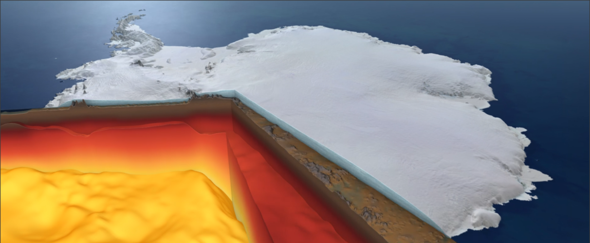
CryoSat sheds new light on Antarctica’s biggest glacier
27.1.2020 17:00
Ice loss from Pine Island Glacier has contributed more to sea-level rise over the past four decades than any other glacier in Antarctica. However, the way this huge glacier is thinning is complex, leading to uncertainty about how it is likely to raise sea level in the future. Thanks to ESA’s CryoSat mission, scientists have now been able to shed new light on these complex patterns of ice loss.
CryoSat sheds new light on ice loss from Antarctica’s biggest glacier
27.1.2020 17:00
Ice loss from Pine Island Glacier has contributed more to sea-level rise over the past four decades than any other glacier in Antarctica. However, the way this huge glacier is thinning is complex, leading to uncertainty about how it is likely to raise sea level in the future. Thanks to ESA’s CryoSat mission, scientists have now been able to shed new light on these complex patterns of ice loss.
Contract secures build of ozone-monitoring Altius satellite
24.1.2020 16:20
ESA has awarded a contract to QinetiQ to build Altius. This new mission will deliver profiles of concentrations of stratospheric ozone with high vertical resolution, as well as profiles of other atmospheric trace gases.
Earth from Space: Deforestation in Bolivia
24.1.2020 10:00 Video:
00:03:15
Video:
00:03:15
This week's edition of the Earth from Space programme features a Copernicus Sentinel-2 mage over an area in the Santa Cruz Department of Bolivia, where part of the tropical dry forest has been cleared for agricultural use.
See also Deforestation in Bolivia to download the image.
Deforestation in Bolivia
24.1.2020 10:00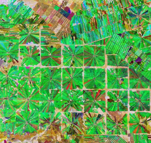 Image:
This Copernicus Sentinel-2 image features an area in the Santa Cruz Department of Bolivia, where part of the tropical dry forest has been cleared for agricultural use.
Since the 1980s, the area has been rapidly deforested owing to a large agricultural development effort where people from the Andean high plains (the Altiplano region) have been relocated to the lowlands of Bolivia.
The relatively flat lowlands and abundant rainfall make this region suitable for farming. In fact, the local climate allows farmers to benefit from two growing seasons. The region has been transformed from dense forest into a patterned expanse of agricultural land. This deforestation method, common in this part of Bolivia, is characterised by the radial patterns that can be seen clearly in the image.
Each patterned field is approximately 20 sq km and each side is around 2.5 km long.
Small settlements can be seen in the centre of each individual field in the image, which typically contain a church, a school and a soccer field. These communities are joined by a road network depicted by the straight lines that bisect the radial fields and connect the adjacent areas.
Meandering streams and rivers can be seen flowing through the fields. The long, thin strips of land in the top right of the image are most likely cultivated soybean fields.
Rainforests worldwide are being destroyed at an alarming rate. This is of great concern as they play an important role in global climate, and are home to a wide variety of plants and animals.
Because of their unique perspective from space, Earth observation satellites are instrumental in providing comprehensive information on the full extent and rate of deforestation, which is particularly useful for monitoring remote areas.
This composite image was created by combing three separate ‘Normalised Difference Vegetation Index’ images from the Copernicus Sentinel-2 mission. The first image, from 8 April 2019, is visible in red; the second from 22 June 2019, can be seen in green; and the third from 5 September 2019 can be seen in blue. The Normalised Difference Vegetation Index is widely used in remote sensing as it gives scientists an accurate measure of healthy and status of plant growth.
This image is also featured on the Earth from Space video programme.
Earth from Space: Deforestation in Bolivia
24.1.2020 10:00
Video:
00:03:15
This week's edition of the Earth from Space programme features a Copernicus Sentinel-2 image over an area in the Santa Cruz Department of Bolivia, where part of the tropical dry forest has been cleared for agricultural use.
See also Deforestation in Bolivia to download the image.
This week's edition of the Earth from Space programme features a Copernicus Sentinel-2 image over an area in the Santa Cruz Department of Bolivia, where part of the tropical dry forest has been cleared for agricultural use.
See also Deforestation in Bolivia to download the image.
Taal volcano blanketed by ash
23.1.2020 13:45The Philippines’ Taal volcano erupted on 12 January 2020 – spewing an ash plume approximately 15 km high and forcing large-scale evacuations in the nearby area.
This almost cloud-free image was captured today 23 January at 02:20 UTC (10:20 local time) by the Copernicus Sentinel-2 mission, and shows the island, in the centre of the image, completely covered in a thick layer of ash.
This optical image has also been processed using the mission’s short-wave infrared band to show the ongoing activity in the crater, visible in bright red. Ash blown by strong winds can be seen in Agoncillo, visible southwest of the Taal volcano. Ash has also recorded in other areas of the Batangas province, as well as Manila and Quezon.
According to The Philippine Institute of Volcanology and Seismology bulletin published today, sulphur dioxide emissions were measured at an average of around 140 tonnes. The Taal volcano still remains on alert level four, meaning an explosive eruption is possible in the coming hours or days. The highest alert level is five which indicates an eruption is taking place.
According to the National Disaster Risk Reduction and Management Council, over 50 000 people have been affected so far. In response to the eruption, the Copernicus Emergency Mapping Service was activated. The service uses satellite observations to help civil protection authorities and, in cases of disaster, the international humanitarian community, respond to emergencies.
Taal volcano blanketed by ash
23.1.2020 13:45The Philippines’ Taal volcano erupted on 12 January 2020 – spewing an ash plume approximately 15 km high and forcing large-scale evacuations in the nearby area.
This almost cloud-free image was captured today 23 January at 02:20 GMT (10:20 local time) by the Copernicus Sentinel-2 mission, and shows the island, in the centre of the image, completely covered in a thick layer of ash.
This optical image has also been processed using the mission’s short-wave infrared band to show the ongoing activity in the crater, visible in bright red. Ash blown by strong winds can be seen in Agoncillo, visible southwest of the Taal volcano. Ash has also been recorded in other areas of the Batangas province, as well as Manila and Quezon.
According to The Philippine Institute of Volcanology and Seismology bulletin published today, sulphur dioxide emissions were measured at an average of around 140 tonnes. The Taal volcano still remains on alert level four, meaning an explosive eruption is possible in the coming hours or days. The highest alert level is five which indicates an eruption is taking place.
According to the National Disaster Risk Reduction and Management Council, over 50 000 people have been affected so far. In response to the eruption, the Copernicus Emergency Mapping Service was activated. The service uses satellite observations to help civil protection authorities and, in cases of disaster, the international humanitarian community, respond to emergencies.
Watch live: Copernicus4regions debate
22.1.2020 16:35
Copernicus4regions: live debate from the European Parliament
On 23 January at 08:30 CET hear how Copernicus is used for public policies
2020 Sentinels calendar
17.1.2020 14:50Sentinels calendar
Download the 2020 Copernicus Sentinels calendar
2020 Sentinels calendar
17.1.2020 14:50Sentinels calendar
Download the 2020 Copernicus Sentinels calendar
Japanese archipelago
17.1.2020 10:00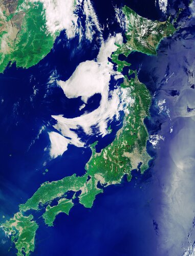 Image:
The Copernicus Sentinel-3 mission takes us over the Japanese archipelago – a string of islands that extends about 3000 km into the western Pacific Ocean.
While the archipelago is made up of over 6000 islands, this image focuses on Japan's four main islands. Running from north to south, Hokkaido is visible in the top right corner, Honshu is the long island stretching in a northeast–southwest arc, Shikoku can be seen just beneath the lower part of Honshu, and Kyushu is at the bottom.
Honshu’s land mass comprises approximately four-fifths of Japan’s total area. Honshu’s main urban areas of Tokyo, Nagoya, and Osaka are clearly visible in the image. The large grey area in the east of the island, near the coast, is Tokyo, while the smaller areas depicted in grey are the areas around Nagoya and Osaka.
Honshu is also home to the country’s largest mountain, Mount Fuji. A volcano that has been dormant since it erupted in 1707, Mount Fuji is around 100 km southwest of Tokyo and its snow covered summit can be seen as a small white dot.
The Sea of Japan, also referred to as the East Sea, (visible to the west of the archipelago) separates the country from the east coast of Asia. The turquoise waters surrounding the island of Hokkaido can be seen at the top of the image, while the waters in the right of the image have a silvery hue because of sunglint – an optical effect caused by the mirror-like reflection of sunlight from the water surface back to the satellite sensor.
Sentinel-3 is a two-satellite mission to supply the coverage and data delivery needed for Europe’s Copernicus environmental monitoring programme. Each satellite’s instrument package includes an optical sensor to monitor changes in the colour of Earth’s surfaces. It can be used, for example, to monitor ocean biology and water quality.
This image, which was captured on 24 May 2019, is also featured on the Earth from Space video programme.
Earth from Space: Japanese archipelago
17.1.2020 10:00 Video:
00:00:00
Video:
00:00:00
In this week's edition of the Earth from Space programme, the Copernicus Sentinel-3 mission takes us over Japan's four main islands.
See also Japanese archipelago to download the image.
Flooding in southern Iran
15.1.2020 15:00 Image:
Heavy rainfall has triggered flooding in southern Iran, particularly in the Sistan and Baluchestan, Hormozgan and Kerman provinces. The downpour has led to blocked roads and destroyed bridges, crops and houses – displacing thousands of people.
This image, captured by the Copernicus Sentinel-2 mission, shows the extent of the flooding in the Sistan and Baluchestan province on 13 January 2020. Flooded areas are visible in brown, while the flooded villages are highlighted by dotted circles. Sediment and mud, caused by the heavy rains, can be seen gushing from the Bahu Kalat River, Iran, and Dasht River, Pakistan, into Gwadar Bay.
Zoom in to view the image of the floods at its full 10 m resolution.
The flooding has also affected Zahedan, as well as Konarak, Saravan, Nik Shahr, Delgan, Bazman, Chabahar, Zarābād and Khash.
In response to the flood, the Copernicus Emergency Mapping Service was activated. The service uses satellite observations to help civil protection authorities and, in cases of disaster, the international humanitarian community, respond to emergencies.
Earth from Space: Faroe Islands
10.1.2020 10:00 Video:
00:02:37
Video:
00:02:37
This week's edition of the Earth from Space programme features a Copernicus Sentinel-2 image over the Faroe Islands – located halfway between Iceland and Norway in the North Atlantic Ocean.
See also Faroe Islands to download the image.
Faroe Islands
10.1.2020 10:00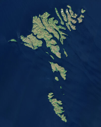 Image:
The Copernicus Sentinel-2 mission takes us over the Faroe Islands, located halfway between Iceland and Norway in the North Atlantic Ocean. The Faroe Islands are an archipelago made up of 18 jagged islands and are a self-governing nation under the external sovereignty of the Kingdom of Denmark.
The archipelago is around 80 km wide and has a total area of approximately 1400 sq km. The official language of the Faroe Islands is Faroese, a Nordic language which derives from the language of the Norsemen who settled the islands over 1000 years ago.
The islands have a population of around 50 000 inhabitants – as well as 70 000 sheep. Around 40% of the population reside in the capital and largest city of the Faroe Islands, Tórshavn, visible on the island of Streymoy, slightly above the centre of the image.
The islands are a popular destination for birdwatchers, particularly on the island of Mykines, the westernmost island of the Faroese Archipelago. The island provides a breeding and feeding habitat for thousands of birds, including the Atlantic Puffins.
Several inland water bodies can be seen dotted around the islands. Lake Sørvágsvatn, the largest lake of the Faroe Islands, is visible at the bottom of Vágar Island to the right of Mykines. Vágar Airport, the only airport in the Faroe Islands, can be seen left of the lake.
In this image, captured on 21 June 2018, several clouds can be seen over the Northern Isles, top right of the image. Low vegetation is visible in bright green.
The unique landscape of the Faroe Islands was shaped by volcanic activity approximately 50 to 60 million years ago. The original plateau was later restructured by the glaciers of the ice age and the landscape eroded into an archipelago characterised by steep cliffs, deep valleys and narrow fjords.
The official language of the Faroe Islands is Faroese, a Nordic language which derives from the language of the Norsemen who settled the islands over 1000 years ago.
The islands are particularly known for their dramatic landscape, grass-roofed houses and treeless moorlands. The Faroe Islands boast over 1000 km of coastline and because of their elongated shape, one can never be more than five km to the ocean from any point of the islands.
This image is also featured on the Earth from Space video programme.
Faroe Islands
10.1.2020 10:00
Image:
The Copernicus Sentinel-2 mission takes us over the Faroe Islands, located halfway between Iceland and Norway in the North Atlantic Ocean. The Faroe Islands are an archipelago made up of 18 jagged islands and are a self-governing nation under the external sovereignty of the Kingdom of Denmark.
The archipelago is around 80 km wide and has a total area of approximately 1400 sq km. The official language of the Faroe Islands is Faroese, a Nordic language which derives from the language of the Norsemen who settled the islands over 1000 years ago.
The islands have a population of around 50 000 inhabitants – as well as 70 000 sheep. Around 40% of the population reside in the capital and largest city of the Faroe Islands, Tórshavn, visible on the island of Streymoy, slightly above the centre of the image.
The islands are a popular destination for birdwatchers, particularly on the island of Mykines, the westernmost island of the Faroese Archipelago. The island provides a breeding and feeding habitat for thousands of birds, including the Atlantic Puffins.
Several inland water bodies can be seen dotted around the islands. Lake Sørvágsvatn, the largest lake of the Faroe Islands, is visible at the bottom of Vágar Island to the right of Mykines. Vágar Airport, the only airport in the Faroe Islands, can be seen left of the lake.
In this image, captured on 21 June 2018, several clouds can be seen over the Northern Isles, top right of the image. Low vegetation is visible in bright green.
The unique landscape of the Faroe Islands was shaped by volcanic activity approximately 50 to 60 million years ago. The original plateau was later restructured by the glaciers of the ice age and the landscape eroded into an archipelago characterised by steep cliffs, deep valleys and narrow fjords.
The islands are particularly known for their dramatic landscape, grass-roofed houses and treeless moorlands. The Faroe Islands boast over 1000 km of coastline and because of their elongated shape, one can never be more than five km to the ocean from any point of the islands.
This image is also featured on the Earth from Space video programme.
Aeolus winds now in daily weather forecasts
10.1.2020 9:00
ESA’s Aeolus satellite has been returning profiles of Earth’s winds since 3 September 2018, just after it was launched – and after months of careful testing these measurements are considered so good that the European Centre for Medium-Range Weather Forecasts is now using them in their forecasts.
Aerosol spread from Australian fires
9.1.2020 16:00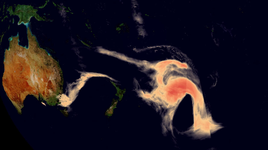 Video:
00:00:20
Video:
00:00:20
Ferocious bushfires have been sweeping across Australia since September, fuelled by record-breaking temperatures, drought and wind. The country has always experienced fires, but this season has been horrific. A staggering 10 million hectares of land have been burned, at least 24 people have been killed and it has been reported that almost half a billion animals have perished. The fires have not only decimated the land, but they have also had a serious effect on air quality.
The Copernicus Sentinel-5 Precursor mission is dedicated to monitoring air pollution by measuring a multitude of trace gases as well as aerosols – all of which affect the air we breathe. This animation shows the immense spread of aerosols from bushfires in southeast Australia between 28 December 2018 and 8 January 2020. These plumes of particles have swept over New Zealand and crossed the South Pacific Ocean, even reaching Chile and Argentina.
Aerosol spread from Australian fires
9.1.2020 16:00
Video:
00:00:20
Ferocious bushfires have been sweeping across Australia since September, fuelled by record-breaking temperatures, drought and wind. The country has always experienced fires, but this season has been horrific. A staggering 10 million hectares of land have been burned, at least 24 people have been killed and it has been reported that almost half a billion animals have perished. The fires have not only decimated the land, but they have also had a serious effect on air quality.
The Copernicus Sentinel-5 Precursor mission is dedicated to monitoring air pollution by measuring a multitude of trace gases as well as aerosols – all of which affect the air we breathe. This animation shows the immense spread of aerosols from bushfires in southeast Australia between 28 December 2019 and 8 January 2020. These plumes of particles have swept over New Zealand and crossed the South Pacific Ocean, even reaching Chile and Argentina.
Australia: like a furnace
9.1.2020 13:59
Ferocious bushfires have been sweeping across Australia since September, fuelled by record-breaking temperatures, drought and wind. The country has always experienced fires, but this season has been horrific. A staggering 10 million hectares of land have been burned, at least 24 people have been killed and it has been reported that almost half a billion animals have perished.
Earth from Space: Tromsø
20.12.2019 10:10 Video:
00:02:34
Video:
00:02:34
This week's edition of the Earth from Space programme features a Copernicus Sentinel-2 image over Tromsø – the largest city in northern Norway.
See also Tromsø, Norway to download the image.
Tromsø, Norway
20.12.2019 10:00 Image:
With Christmas almost here, the red and white of this Copernicus Sentinel-2 image bring a festive feel to this week’s image featuring Tromsø – the largest city in northern Norway.
This false-colour image was processed in a way that included the near-infrared channel, which makes vegetation appear bright red. The snow over the surrounding mountains is visible in white, adding to the Christmassy feel of the image.
Most of Tromsø, lies on the island of Tromsøya, visible at the top of the image. Owing to its northerly location, the city is a popular area to experience the majestic phenomenon of the aurora borealis, or northern lights.
Tromsø is over 300 km north of the Arctic Circle. During the winter, it’s shrouded in darkness – the Sun sets in late-November and doesn’t rise again until January. The image was captured on 15 October 2019, which means it is one of the last images that Sentinel-2 could acquire before darkness descended.
During the long winter months, the Copernicus Sentinel-1 mission is used to monitor this region instead of Sentinel-2. As an advanced radar mission, Copernicus Sentinel-1 can image the surface of Earth through cloud and rain and regardless of whether it is day or night.
In September 2019, the German research icebreaker Polarstern left from Tromsø for a mammoth Arctic expedition. The Multidisciplinary drifting Observatory for the Study of Arctic Climate (MOSAiC) expedition involves the icebreaker spending a year drifting in the Arctic sea ice.
Spearheaded by the Alfred Wegener Institute (AWI), MOSAiC is the biggest shipborne polar expedition of all time. The data gathered during the expedition will be used by scientists around the world to study the Arctic as the epicentre of global warming and gain fundamental insights that are key to better understand global climate change.
This image is also featured on the Earth from Space video programme.
Methane leak visible from space
17.12.2019 16:55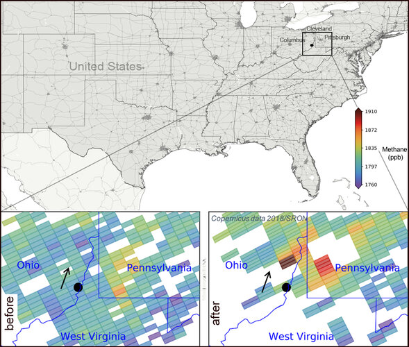 Image:
Data from the Copernicus Sentinel-5P satellite revealed that an explosion in a natural gas well in Ohio in February 2018 released more than 50 000 tons of methane into the atmosphere. The blowout leaked more of this potent greenhouse gas in 20 days than the majority of many European nations do in a year from their oil and gas industries.
Data from the Copernicus Sentinel-5P’s Tropomi instrument revealed that 120 tons of methane were emitted per hour due to the blowout. The findings were published in a study yesterday in the Proceedings of the National Academy of Sciences, and reveals the importance of using satellite data to detect and quantify pollutants such as methane.
The location of the explosion is marked by a black dot in the image, and shows the methane emissions before and after the blowout. The black arrow indicates the wind direction and the direction of the methane plume.
Claus Zehner, ESA’s Copernicus Sentinel-5P mission manager, comments, “These Sentinel-5P measurements show that satellites can measure the concentrations of greenhouse gases emitted by a point source. The satellite’s capabilities will be further exploited with the upcoming Copernicus Carbon Dioxide Monitoring mission.”
While carbon dioxide is more abundant in the atmosphere and therefore more commonly associated with global warming, methane is about 30 times more potent as a heat-trapping gas. It usually enters the atmosphere mainly from the fossil fuel industry, landfill sites, livestock farming, rice agriculture and wetlands – but can also be released during oil and gas extraction.
Sentinel-5P, with its state-of-the-art instrument Tropomi, can also map other pollutants such as nitrogen dioxide, carbon monoxide, sulphur dioxide and aerosols – all of which affect the air we breathe and our climate.
Methane leak visible from space
17.12.2019 16:55
Image:
Data from the Copernicus Sentinel-5P satellite revealed that an explosion in a natural gas well in Ohio in February 2018 released more than 50 000 tons of methane into the atmosphere. The blowout leaked more of this potent greenhouse gas in 20 days than the majority of many European nations do in a year from their oil and gas industries.
The findings were published in a study yesterday in the Proceedings of the National Academy of Sciences, and the study reveals the importance of using satellite data to detect and quantify pollutants such as methane. Data from the Copernicus Sentinel-5P’s Tropomi instrument revealed that 120 tons of methane were emitted per hour due to the blowout.
The location of the explosion is marked by a black dot in the image, and shows the methane emissions before and after the blowout. The black arrow indicates the wind direction and the direction of the methane plume.
Claus Zehner, ESA’s Copernicus Sentinel-5P mission manager, comments, “These Sentinel-5P measurements show that satellites can measure the concentrations of greenhouse gases emitted by a point source. The satellite’s capabilities will be further exploited with the upcoming Copernicus Carbon Dioxide Monitoring mission.”
While carbon dioxide is more abundant in the atmosphere and therefore more commonly associated with global warming, methane is about 30 times more potent as a heat-trapping gas. It usually enters the atmosphere mainly from the fossil fuel industry, landfill sites, livestock farming, rice agriculture and wetlands – but can also be released during oil and gas extraction.
Sentinel-5P, with its state-of-the-art instrument Tropomi, can also map other pollutants such as nitrogen dioxide, carbon monoxide, sulphur dioxide and aerosols – all of which affect the air we breathe and our climate.
Shedding light in the dark: radar satellites lead the way
16.12.2019 12:25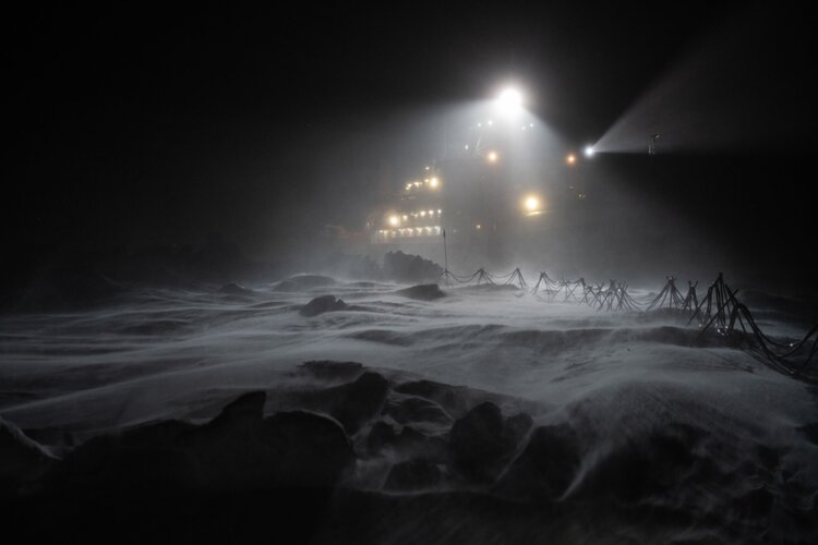
Spare a thought this Christmas for researchers hunkered down on their Polarstern icebreaker, adrift in the frozen Arctic Ocean. Subjected to temperatures as low as –45°C and the perpetual darkness of the polar winter, they are willing participants in MOSAiC – the world’s largest and longest polar research expedition. Despite the darkness, however, the researchers and crew remain aware of what is happening close by. How? With the help of radar imaging satellites.
CryoSat maps ice shelf on the move
13.12.2019 11:00
It is now almost 10 years since ESA’s CryoSat was launched. Throughout its decade in orbit, this novel satellite, which carries a radar altimeter to measure changes in the height of the world’s ice, has returned a wealth of information about how ice sheets, sea ice and glaciers are responding to climate change. One of the most recent findings from this extraordinary mission shows how it can be used to map changes in the seaward edges of Antarctic ice shelves.
Earth from Space: Gotland Baltic blooms
13.12.2019 10:00 Video:
00:00:00
Video:
00:00:00
In this week's edition of the Earth from Space programme, Copernicus Sentinel-2 takes us over the green algae blooms swirling around the Baltic Sea.
See also Baltic blooms to download the image.
Baltic blooms
13.12.2019 10:00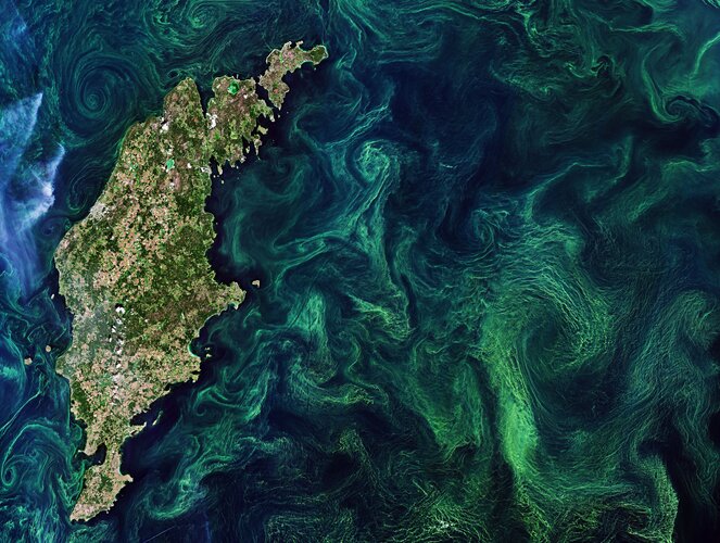 Image:
The Copernicus Sentinel-2 mission takes us over the green algae blooms swirling around the Baltic Sea.
'Algae bloom' is the term used to describe the rapid multiplying of phytoplankton – microscopic marine plants that drift on or near the surface of the sea. The chlorophyll that phytoplankton use for photosynthesis collectively tints the surrounding ocean waters, providing a way of detecting these tiny organisms from space.
In most of the Baltic Sea, there are two annual blooms – the spring bloom and the cyanobacterial (also called blue-green algae) bloom in late summer. The Baltic Sea faces many serious challenges, including toxic pollutants, deep-water oxygen deficiencies, and toxic blooms of cyanobacteria affecting the ecosystem, aquaculture and tourism.
Cyanobacteria have qualities similar to algae and thrive on phosphorus in the water. High water temperatures and sunny, calm weather often lead to particularly large blooms that pose problems to the ecosystem.
In this image captured on 20 July 2019, the streaks, eddies and whirls of the late summer blooms, mixed by winds and currents, are clearly visible. Without in situ measurements, it is difficult to distinguish the type of algae that covers the sea as many different types of algae grow in these waters.
The highest concentrations of algal blooms are said to occur in the Central Baltic and around the island of Gotland, visible to the left in the image.
Although algal blooms are a natural and essential part of life in the sea, human activity is also said to increase the number of annual blooms. Agricultural and industrial run-off pours fertilisers into the sea, providing additional nutrients algae need to form large blooms.
The bacteria that consume the decaying plants suck oxygen out of the water, creating dead zones where fish cannot survive. Large summer blooms can contain toxic algae that are dangerous for both humans and other animals.
Satellite data can track the growth and spread of harmful algae blooms in order to alert and mitigate against damaging impacts for tourism and fishing industries.
This image is also featured on the Earth from Space video programme.
Earth observation at Space, Security and Defence event
11.12.2019 10:15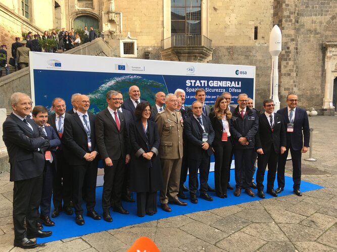
On 6 December, representatives from ESA, the European Parliament, the European Commission and the Italian Space Agency met at the States General for Space, Security and Defence event in Naples, Italy, to discuss upcoming challenges for European industry.
Greenland ice loss much faster than expected
10.12.2019 19:35
The Greenland ice sheet is losing mass seven times faster than in the 1990s, according to new research.
Satellites key to '10 Insights in Climate Science' report
6.12.2019 16:04
A new easy-to-read guide, ‘10 New Insights in Climate Science’ has been presented to the United Nations Framework Convention on Climate Change’s Executive Secretary, Patricia Espinosa, at the COP25 climate conference.
New biomass map to take stock of the world’s carbon
6.12.2019 15:30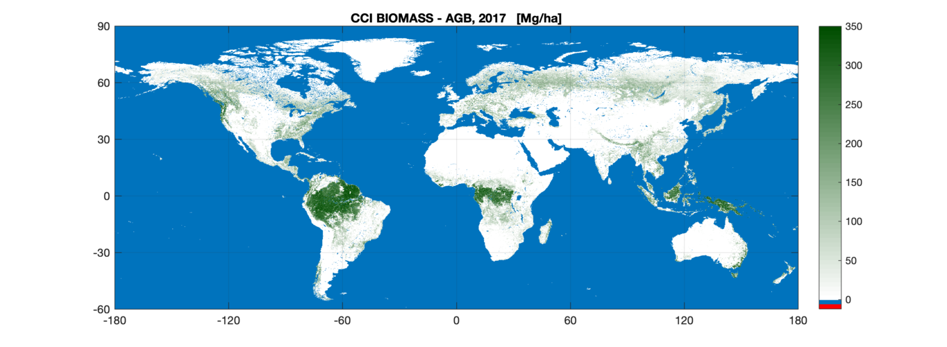
The first of a series of global maps aimed at quantifying change in carbon stored as biomass across the world’s forests and shrublands has been released today by ESA’s Climate Change Initiative at COP25 – the United Nation Climate Change Conference currently taking place in Madrid.
Earth from Space: Mato Grosso
6.12.2019 10:00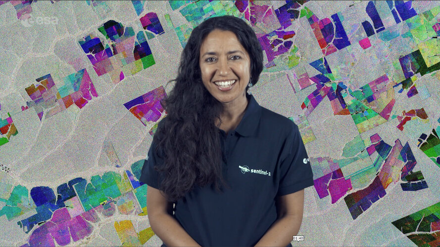 Video:
00:02:33
Video:
00:02:33
In this week's edition of the Earth from Space programme, the Copernicus Sentinel-1 mission takes us over part of the Brazilian state of Mato Grosso deep in the Amazon interior.
See also Mato Grosso, Brazil to download the image.
Mato Grosso, Brazil
6.12.2019 10:00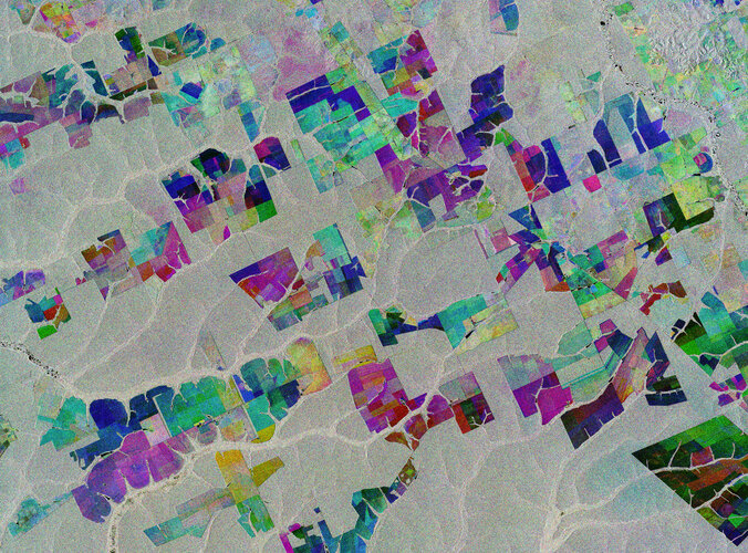 Image:
The Copernicus Sentinel-1 mission takes us over part of the Brazilian state of Mato Grosso deep in the Amazon interior.
This image combines three separate radar images from the Copernicus Sentinel-1 mission taken about two years apart to show change in crops and land cover over time.
Unlike images from satellites carrying optical or ‘camera-like’ instruments, images acquired with imaging radar are interpreted by studying the intensity of the backscatter radar signal, which is related to the roughness of the ground.
Here, the first image, from 2 May 2015, is picked out in blue; the second, from 16 March 2017, picks out changes in green; and the third from 18 March 2019 in red; areas in grey depict little or no change between 2015 and 2019.
Ironically, Mato Grosso means ‘great woods’, but, as these coloured rectangular shapes portray, much of the tropical forest has been cut down and given over to farming. While this image only shows a small area, Mato Grosso is one of Brazil’s top cattle-producing and crop-producing states, with the main crops including corn, soya and wheat.
However, although the state has one of the highest historical rates of deforestation in Amazonian Brazil, deforestation is slowing and Mato Grosso is now said to be a global leader in climate-change solutions.
As an advanced radar mission, Copernicus Sentinel-1 can image the surface of Earth through cloud and rain and regardless of whether it is day or night. This makes it ideal for monitoring areas that tend to be covered by cloud such as rainforests.
This image is also featured on the Earth from Space video programme.
New 35-year satellite data record charts sea-temperature change
5.12.2019 17:47
Four trillion satellite measurements, taken over four decades from 1981 to 2018, have been merged to create a continuous global record and will help to understand the science behind Earth’s climate.
A paper published recently in Nature Scientific Data describes how this new dataset of global sea-surface temperature is one of the longest satellite climate data records available. The dataset will play a key role in evaluating global models used to predict how our oceans will influence future climate change.
35-year data record charts sea-temperature change
5.12.2019 17:47
Four trillion satellite measurements, taken over four decades from 1981 to 2018, have been merged to create a continuous global record that will help to understand the science behind Earth’s climate.
A paper published recently in Nature Scientific Data describes how this new dataset of global sea-surface temperature is one of the longest satellite climate data records available. The dataset will play a key role in evaluating global models used to predict how our oceans will influence future climate change.
35-year data record charts sea temperature change
5.12.2019 17:47
Four trillion satellite measurements, taken over four decades from 1981 to 2018, have been merged to create a continuous global record that will help to understand the science behind Earth’s climate.
A paper published recently in Nature Scientific Data describes how this new dataset of global sea-surface temperature is one of the longest satellite climate data records available. The dataset will play a key role in evaluating global models used to predict how our oceans will influence future climate change.
Sentinel-6 Mission
5.12.2019 14:00 Video:
00:05:20
Video:
00:05:20
In a cleanroom in Ottobrunn, Germany, the latest Copernicus Sentinel satellite is ready for final testing before it is packed up and shipped to the US for liftoff next year. Designed and built to chart changing sea level, it is the first of two identical Sentinel-6 satellites that will be launched consecutively to continue the time series of sea-level measurements. This new mission builds on heritage from previous ocean topography satellites, including the French–US Topex-Poseidon and Jason missions, previous ESA missions such as the ERS satellites, Envisat and CryoSat, as well as Copernicus Sentinel-3. With millions of people around the world at risk from rising seas, it is essential to continue measuring the changing height of the sea surface so that decision-makers are equipped to take appropriate mitigating action – as is being currently highlighted at the COP-25 Climate Change Conference in Spain.
Sentinel-6: charting sea level
5.12.2019 14:00 Video:
00:05:20
Video:
00:05:20
In a cleanroom in Ottobrunn, Germany, the latest Copernicus Sentinel satellite is ready for final testing before it is packed up and shipped to the US for liftoff next year. Designed and built to chart changing sea level, it is the first of two identical Sentinel-6 satellites that will be launched consecutively to continue the time series of sea-level measurements. This new mission builds on heritage from previous ocean topography satellites, including the French–US Topex-Poseidon and Jason missions, previous ESA missions such as the ERS satellites, Envisat and CryoSat, as well as Copernicus Sentinel-3. With millions of people around the world at risk from rising seas, it is essential to continue measuring the changing height of the sea surface so that decision-makers are equipped to take appropriate mitigating action – as is being currently highlighted at the COP-25 Climate Change Conference in Spain.
Green City Watch grabs top prize at Copernicus Masters
5.12.2019 11:20
Green City Watch won this year’s Copernicus Masters competition in a ceremony held yesterday at the European Space Week in Helsinki, Finland. Using Copernicus Sentinel satellite data, this application combines big data from space with artificial intelligence to measure the quality of green urban spaces.
ESA at COP25
3.12.2019 9:10
The European parliament declared a climate emergency ahead of the latest UN COP25 Climate Change Conference taking place over the next two weeks in Madrid. The 12-day summit will focus on encouraging governments to increase their commitments to combatting climate change. ESA is present highlighting the vital importance of observing our changing world from space and showing how data from satellites play a critical role in underpinning climate policy.
New maps of salinity reveal the impact of climate variability on oceans
30.11.2019 14:26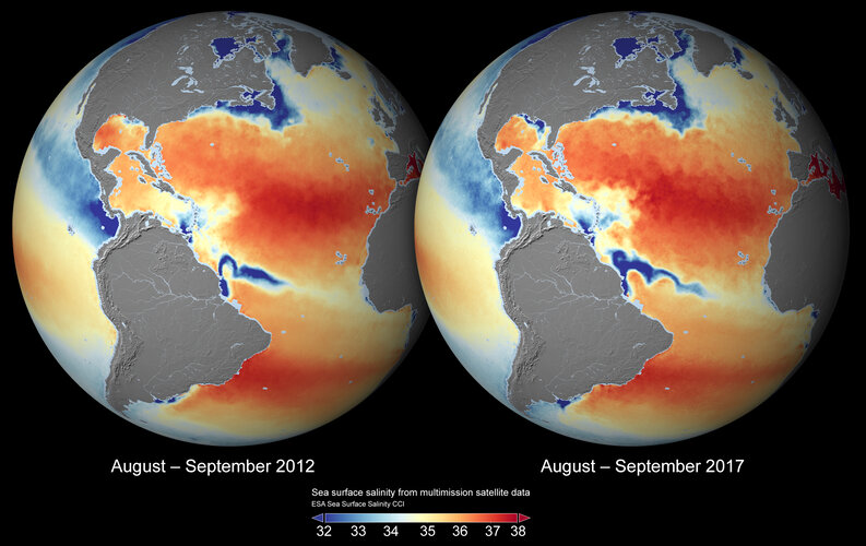
Since the saltiness of ocean surface waters is a key variable in the climate system, understanding how this changes is important to understanding climate change. Thanks to ESA’s Climate Change Initiative, scientists now have better insight into sea-surface salinity with the most complete global dataset ever produced from space.
ɸ-Sat-2 challenge
30.11.2019 7:22
ɸ-Sat-2 challenge
Submit your idea for the AI ɸ-Sat-2 mission. Deadline 31 January 2020.
Earth from Space: Lake St. Clair
29.11.2019 10:00 Video:
00:02:39
Video:
00:02:39
In this week's edition of the Earth from Space programme, the Copernicus Sentinel-2 mission takes us over Lake St. Clair, forming the border between Ontario, Canada to the east, and Michigan, US to the west.
See also Lake St. Clair to download the image.
Lake St. Clair
29.11.2019 10:00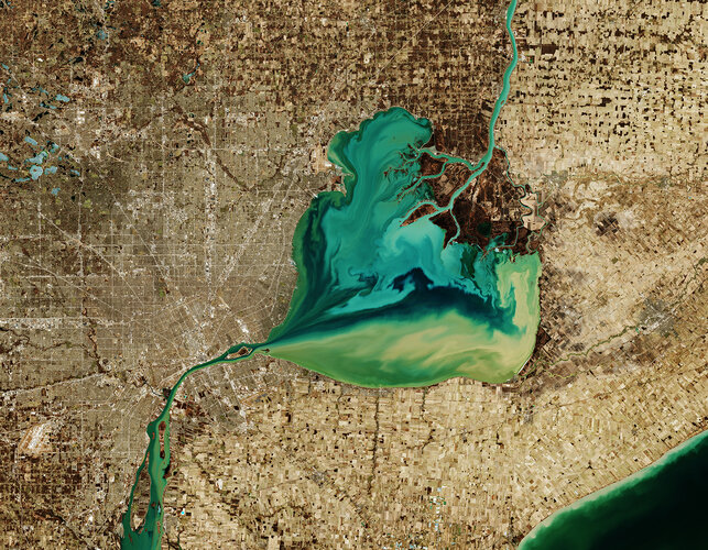 Image:
The Copernicus Sentinel-2 mission takes us over Lake St. Clair, forming the border between Ontario, Canada to the east, and Michigan, US to the west.
The Saint Clair River is visible at the top of the image and flows southwards, connecting the southern end of Lake Huron with Lake St. Clair, visible in the centre of the image. The river branches into several channels before reaching the lake, creating a seven-mouth delta. Much of the area surrounding the delta is used for agriculture.
The Thames River, visible east of the lake, begins in a swampy area of Ontario, before emptying its muddy waters into Lake St. Clair. Here the murky-coloured waters mix with the turquoise waters from the Saint Clair River, creating this fusion of colour visible in the heart-shaped lake. The waters then exit the lake via the Detroit River.
Lake St. Clair is approximately 40 km long and 40 km wide, with an average depth of around 3 metres. The lake is a popular site for fishing and boating, and more than 100 species of fish inhabit the lake including walleye, rainbow trout and muskellunge.
Detroit, the largest city in Michigan, is visible directly above the Detroit River. The city lies on a relatively flat plain and its extensive network of roads in the city are clearly visible in the image.
Detroit is nicknamed the “motor city” as it was the key hub for American auto-manufacturing for over a century. It was also home to the first mile of concrete highway, the first four-way three-colour traffic light and the world’s first urban freeway.
In this wintery image, captured on 26 March 2019, many of the frozen lakes northwest of the lake can be seen partially frozen over. The Copernicus Sentinel-2 mission allows inland bodies of water to be closely monitored.
This image is also featured on the Earth from Space video programme.
Space is key to monitoring ocean acidification
28.11.2019 13:40
This week, the UN World Meteorological Organization announced that concentrations of greenhouse gases in the atmosphere have reached yet another high. This ongoing trend is not only heating up the planet, but also affecting the chemical composition of our oceans. Until recently, it has been difficult to monitor ‘ocean acidification’, but scientists are exploring new ways to combine information from different sources, including from ESA’s SMOS mission, to shed new light on this major environmental concern.
Steve over the picket fence
27.11.2019 16:30
Strange ribbons of purple light that appeared in the sky – known as Steve – became the subject of debate in 2017, as their origins were unbeknown to scientists. Now, photographs of this remarkable phenomena have been studied to understand their exact position in the night sky.
Attica floods
27.11.2019 8:40 Image:
With heavy rain causing flooding and mudslides in both Italy and France this week, parts of Greece have also been affected. The region of Attica, west of Athens, received torrential rain leading to hundreds of houses being flooded – particularly in the beach town of Kineta.
Using images from the Copernicus Sentinel-2 mission, the animation shows the before-and-after of the recent floods from the 24 November. Sediment and mud, caused by the heavy rains, can be seen gushing into the Megara Gulf – stretching 14 km from the coast. Debris, most likely vegetation and rubbish, is visible in brown floating in the waters.
Click here to view the image of the floods at its full 10 m resolution.
The burnt areas surrounding Kineta, following last year’s wildfires, can also be seen in the image. According to Greek media, the downpour led to overturned cars and roads blocked owing to the debris.
The Copernicus Emergency Mapping Service was activated to help respond to the flood. The service uses satellite observations to help civil protection authorities and, in cases of disaster, the international humanitarian community, respond to emergencies.
Spain joins Copernicus Sentinel Collaborative Ground Segment
26.11.2019 16:35
Today, ESA and Spain’s Centre for the Development of Industrial Technology signed an understanding that will boost Spain’s access to Copernicus Sentinel data.
Floods in northern Italy
26.11.2019 10:31 Image:
Torrential downpours have battered many parts of Italy this month, with extreme flooding wreaking havoc across northern Italy. The province of Alessandria is said to be one of the worst-affected areas according to Italian media, with around 200 people evacuated and 600 said to be left stranded.
This multi-temporal image uses two separate images captured by the Copernicus Sentinel-1 mission on 13 November and 25 November. The flooded areas can be seen depicted in red, the Po River in black, and urban areas in white.
Copernicus Sentinel-1’s radar ability to ‘see’ through clouds and rain, and in darkness, makes it particularly useful for monitoring floods. It can even easily differentiate water bodies, highlighting the difference between the Po River in black, and the extent of the flooding in red.
Around 500 people were evacuated further north in the Aosta Valley, where many roads were closed in fear of potential avalanches. Part of a viaduct serving the A6 motorway near Savona, in the northern region of Liguria, was washed away by a mudslide – leaving a 30 m gap in the road.
Images acquired before and after flooding offer immediate information on the extent of inundation and support assessments of property and environmental damage.
Earlier this month, the Copernicus Emergency Mapping Service was activated to help respond to the floods in northeast Italy, where Venice saw record-breaking water levels and the worst flooding in 50 years.
Testing time for MetOp Second Generation
25.11.2019 15:32
ESA’s ESTEC Test Centre in the Netherlands has completed its initial test campaign for the future of European weather forecasting – MetOp Second Generation.
Earth from Space: Seville
22.11.2019 10:00 Video:
00:02:39
Video:
00:02:39
In this week's edition of the Earth from Space programme, the Copernicus Sentinel-2 mission takes us over Seville in southern Spain, where ESA's next Ministerial Council will soon take place.
See also Seville, Spain to download the image.
Seville, Spain
22.11.2019 10:00
Image:
Ahead of next week’s ‘Space19+’ Ministerial Council, the Copernicus Sentinel-2 mission takes us over Seville in southern Spain – the destination for this milestone event.
On 27–28 November, Ministers from ESA’s Member States along with Associate Member Slovenia and Cooperating State Canada will meet in Seville for the ESA Council at Ministerial Level Space19+ to discuss future space activities for Europe and the budget of Europe’s space agency for the coming three years. Space19+ is an opportunity to direct Europe’s ‘next generation’ ambitions in space, and address the challenges facing not only the European space sector, but also European society as a whole.
Seville, visible towards the top right of this image, is the capital of Andalusia and the fourth largest city in Spain. An inland port, it lies on the Guadalquivir River and while the original course of the river is visible snaking through the city on the right, we can see where water has also been redirected into a straighter course on the left. At over 650 km long, the Guadalquivir is one of the longest rivers in Spain, extending way beyond the frame of this image. Nevertheless, it can be seen winding its course all the way from the top right of the image, just south of the Sierra Norte mountain range, to the Gulf of Cádiz where it empties into the Atlantic Ocean. On route, this major river serves as a source for irrigation – here noticeable in the top right of the image, but mainly to the south of Seville where large green agricultural fields appear in sharp contrast to the surrounding drier brown land.
The Doñana National Park lies on the right bank of the Guadalquivir River, at its estuary on the Atlantic Ocean. One of Europe's most important wetland reserves, the park is an area of marsh, shallow streams and sand dunes, and an important site for endangered and migrating birds.
Copernicus Sentinel-2 is a two-satellite mission. Each satellite carries a high-resolution camera that images Earth’s surface in 13 spectral bands. Data from Copernicus Sentinel-2 are used to monitor changes in land cover, agriculture, and coastal and inland waters.
This image, captured on 21 June 2019, is also featured on the Earth from Space video programme.
Smoke in New South Wales
21.11.2019 17:00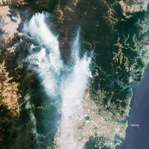 Image:
The Copernicus Sentinel-2 mission captured the plumes of smoke from the bushfires in Australia. The recent blazes triggered a ‘hazardous’ air quality warning for Sydney – the highest level on Australia’s Air Quality Index.
In this image, captured on 21 November 2019 at 00:02 GMT (11:02 local time), smoke from the Gospers Mountain bushfires, northwest of Sydney, can be seen drifting southwards. Residents with respiratory conditions were advised by authorities to stay indoors, as over 50 people have been treated owing to complications from the smoke.
According to the New South Wales Rural Fire Service, as of 21:00 local time, there were over 60 bush and grass fires burning in New South Wales, of which over 20 still need to be contained. In Victoria, another 60 blazes are burning – although the exact number is unknown as new fires have been sparked by recent lightning.
Hundreds of bushfires have been burning this month in Australia, with the greatest damage seen in New South Wales and Queensland.
French earthquake fault mapped
17.11.2019 13:18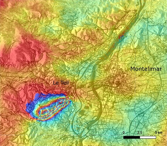
This week, southeast France was hit by a magnitude 5 earthquake with tremors felt between Lyon and Montélimar. The Copernicus Sentinel-1 radar mission has been used to map the way the ground shifted as a result of the quake.
Sea-level monitoring satellite on show
15.11.2019 14:00
Media representatives and mission partners gathered today in Germany to see a new satellite, which will take the lead in charting sea-level change, before it undergoes final testing and is packed up for shipment to the US for lift-off next year.
Earth from Space: Lake Tai
15.11.2019 10:00 Video:
00:02:45
Video:
00:02:45
In this week's edition of the Earth from Space programme, the Copernicus Sentinel-2 mission takes usoverthe third largest freshwater lake in China.
See also Lake Tai, China to download the image.
Lake Tai, China
15.11.2019 10:00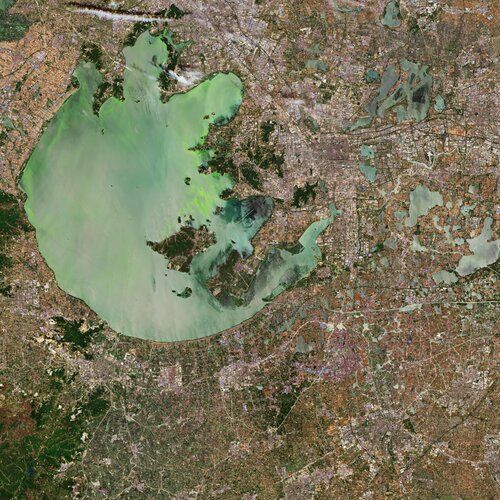 Image:
The Copernicus Sentinel-2 mission takes us over the Lake Tai, the third largest freshwater lake in China. The lake, also known as Lake Taihu, is located in the Jiangsu province and is approximately 70 km long and 60 km wide, with an average water depth of approximately 2 metres. The lake discharges its waters through Wusong, Liu, Huangpu and several other rivers.
The Tai Basin is a very developed region in China, and includes the megacities Suzhou, visible east of the lake, Wuxi, visible north of the lake, and the nearby Shanghai. Over the past decades, rapid urbanisation, population growth and excessive fish farming have resulted in eutrophication – where the lake becomes enriched with minerals and nutrients.
The increase of nutrients deteriorate the water quality of the lake causing toxic algae blooms to form on the lake’s surface – threatening the quality for millions of people who depend on the lake as a source of drinking water.
In 2007, the algal blooms were so severe that the outbreak was declared a health emergency. Water supplies to Wuxi were suspended, leaving two million residents without drinking water for several weeks.
In this image captured on 24 May 2019, the algae-infested waters are clearly visible.
Algae blooms have been reported in the lake since the 1980s. Many attempts have been made to salvage the water quality of the lake including removal of the algae, closing chemical and manufacturing plants near Tai and stricter water treatment regulations.
However, the lake remains to be highly polluted. Agriculture, sewage and manufacturing still affect the lake’s waters – overloading it with nutrients.
Sentinel-2 is a two-satellite mission to supply the coverage and data delivery needed for Europe’s Copernicus programme. The mission’s frequent revisits over the same area and high spatial resolution allow changes in inland water bodies to be closely monitored.
This image is also featured on the Earth from Space video programme.
Earth from Space: Lake Tai
15.11.2019 10:00
Video:
00:02:45
In this week's edition of the Earth from Space programme, the Copernicus Sentinel-2 mission takes us over the third largest freshwater lake in China.
See also Lake Tai, China to download the image.
ɸ-Sat-2 challenge
14.11.2019 16:22
ɸ-Sat-2 challenge
Submit your idea for the AI ɸ-Sat-2 mission. Deadline 15 January 2020.
ɸ-Sat-2 challenge
14.11.2019 16:22
ɸ-Sat-2 challenge
Submit your idea for the AI ɸ-Sat-2 mission. Deadline 15 January 2020.
Bushfires rage in Australia
13.11.2019 15:30 Image:
The Copernicus Sentinel-3 mission captured the multiple bushfires burning across Australia’s east coast. Around 150 fires are still burning in New South Wales and Queensland, with hot and dry conditions accompanied with strong winds, said to be spreading the fires.
In this image, captured on 12 November 2019 at 23:15 UTC (13 November 09:15 local time), the fires burning near the coast are visible. Plumes of smoke can be seen drifting east over the Tasman Sea. Hazardous air quality owing to the smoke haze has reached the cities of Sydney and Brisbane and is affecting residents, the Australian Environmental Department has warned.
Hundreds of homes have been damaged or destroyed, and many residents evacuated. Flame retardant was dropped in some of Sydney’s suburbs as bushfires approached the city centre. Firefighters continue to keep the blazes under control.
The Copernicus Emergency Mapping Service was activated to help respond to the fires. The service uses satellite observations to help civil protection authorities and, in cases of disaster, the international humanitarian community, respond to emergencies.
Quantifying and monitoring fires is fundamental for the ongoing study of climate, as they have a significant impact on global atmospheric emissions. Data from the Copernicus Sentinel-3 World Fire Atlas shows that there were almost five times as many wildfires in August 2019 compared to August 2018.
Bushfires rage in Australia
13.11.2019 15:30
Image:
The Copernicus Sentinel-3 mission captured the multiple bushfires burning across Australia’s east coast. Around 150 fires are still burning in New South Wales and Queensland, with hot and dry conditions accompanied with strong winds, said to be spreading the fires.
In this image captured on 12 November 2019 at 23:15 UTC (13 November 09:15 local time), the fires burning near the coast are visible. Plumes of smoke can be seen drifting east over the Tasman Sea. Hazardous air quality owing to the smoke haze has reached the cities of Sydney and Brisbane and is affecting residents, the Australian Environmental Department has warned.
Hundreds of homes have been damaged or destroyed, and many residents evacuated. Flame retardant was dropped in some of Sydney’s suburbs as bushfires approached the city centre. Firefighters continue to keep the blazes under control.
The Copernicus Emergency Mapping Service was activated to help respond to the fires. The service uses satellite observations to help civil protection authorities and, in cases of disaster, the international humanitarian community, respond to emergencies.
Quantifying and monitoring fires is fundamental for the ongoing study of climate, as they have a significant impact on global atmospheric emissions. Data from the Copernicus Sentinel-3 World Fire Atlas shows that there were almost five times as many wildfires in August 2019 compared to August 2018.
Bushfires rage in Australia
13.11.2019 15:30
Image:
The Copernicus Sentinel-3 mission captured the multiple bushfires burning across Australia’s east coast. Around 150 fires are still burning in New South Wales and Queensland, with hot and dry conditions accompanied with strong winds, said to be spreading the fires.
In this image, captured on 12 November 2019 at 23:15 UTC (13 November 09:15 local time), the fires burning near the coast are visible. Plumes of smoke can be seen drifting east over the Tasman Sea. Hazardous air quality owing to the smoke haze has reached the cities of Sydney and Brisbane and is affecting residents, the Australian Environmental Department has warned.
Hundreds of homes have been damaged or destroyed, and many residents evacuated. Flame retardant was dropped in some of Sydney’s suburbs as bushfires approached the city centre. Firefighters continue to keep the blazes under control.
The Copernicus Emergency Mapping Service was activated to help respond to the fires. The service uses satellite observations to help civil protection authorities and, in cases of disaster, the international humanitarian community, respond to emergencies.
Quantifying and monitoring fires is fundamental for the ongoing study of climate, as they have a significant impact on global atmospheric emissions. Data from the Copernicus Sentinel-3 World Fire Atlas shows that there were almost five times as many wildfires in August 2019 compared to August 2018.
Improving new Aeolus wind data for forecasts
12.11.2019 17:09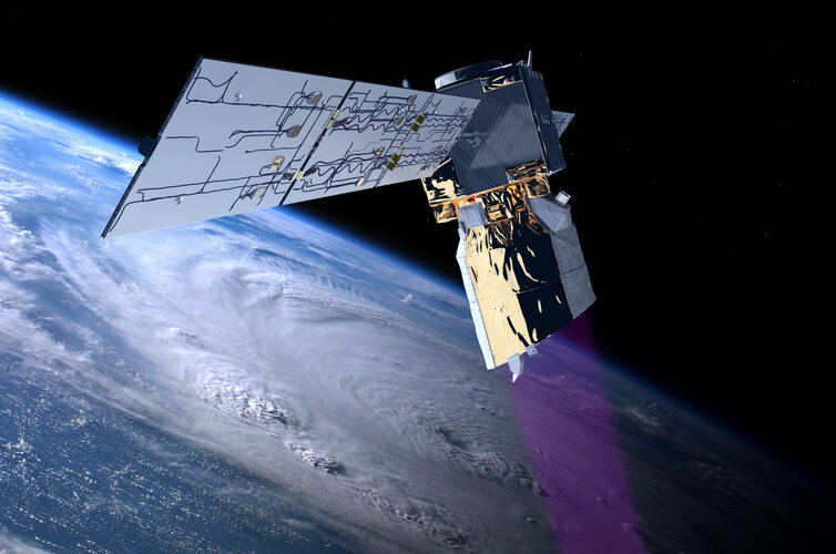
Tests carried out show that new wind profile observations from ESA’s Aeolus satellite significantly improves weather forecasts – particularly in the southern hemisphere and the tropics.
Improving new Aeolus wind data for forecasts
12.11.2019 17:09
Tests carried out show that new wind profile observations from ESA’s Aeolus satellite significantly improve weather forecasts – particularly in the southern hemisphere and the tropics.
Earth from Space: Holbox Island
8.11.2019 10:00 Video:
00:02:41
Video:
00:02:41
In this week's edition of the Earth from Space programme, the Copernicus Sentinel-2 mission takes us over Holbox Island, off the Quintana Roo coast of Mexico.
See also Holbox Island, Mexico to download the image.
Holbox Island, Mexico
8.11.2019 10:00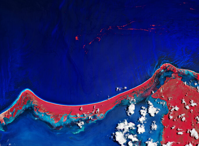 Image:
The Copernicus Sentinel-2 mission takes us over Holbox Island, off the Quintana Roo coast of Mexico. The island is separated from mainland Mexico by a shallow lagoon. This false-colour image has been processed in a way that highlights vegetation in bright red.
Holbox Island is around 40 km long and only approximately 1.5 km wide. The island is located within the Yum Balam Flora and Fauna Protection Area, established in 1994.
Encompassing more than 150 000 hectares, Yum Balam is home to several endangered species including jaguars, crocodiles and monkeys. The waters of Yum Balam are rich fishing areas and also home to whale sharks, over 400 species of bird, and over 70 different species of reptiles and amphibians.
This summer, a large quantity of the brown seaweed known as Sargassum washed up on the shores of Mexico. The brown algae is an important habitat for many species, yet when it collects along coastlines it rots and produces a pungent smell – causing havoc for both the environment and tourist industry.
In this image, captured on 6 July 2019, the Sargassum floating in the sea can be seen in bright red.
From 24 to 26 October, the first ever Sargassum International Conference took place in Guadeloupe where organisations and companies came together to discuss seaweed monitoring to find solutions to the massive increase being washed up in coastal communities.
Earth observation data are important in monitoring Sargassum, as the data can help local services and organisations monitor blooms at sea, and forecast when they are likely to arrive on shore, allowing local communities to act and plan accordingly.
As part of ESA’s Earth Observation Science for Society initiative, ESA joined forces with CLS-NovaBlue Environment, to monitor floating Sargassum in the Caribbean area using data from the Copernicus Sentinel-2 and Sentinel-3 missions.
This image is also featured on the Earth from Space video programme.
Ozone hole set to close
8.11.2019 8:50
The size of the ozone hole fluctuates – usually forming each year in August, with its peak in October, before finally closing in late November or December. Not only will the hole close earlier than usual in 2019, but it is also the smallest it has been in 30 years owing to unusual atmospheric conditions.
Earth images in vogue
7.11.2019 13:51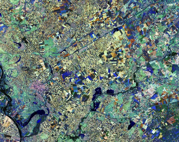 Image:
Images of Earth from space meet fashion this week as Vogue magazine features the ‘Fragility and Beauty’ exhibition in Milan, Italy. Through several satellite images, the Italian online edition of Vogue highlights how the exhibition creates a link between scientific research, space technology and art, focusing on the theme of climate change and sustainable development.
Organised by ESA and the Italian Space Agency and inaugurated in May this year, the ‘Fragility and Beauty’ exhibition can be seen at the Italian National Museum of Science and Technology in Milan.
This image of northern Serbia is just one of the many beautiful images from space included in the exhibition.
Originally featured on ESA’s Earth from Space video programme, this particular image was taken by the Copernicus Sentinel-2 mission on 28 August 2016. It is a false-colour image, and apart from being beautiful, the different colours indicate varying vegetative states. For example, yellowish patches indicate soil or freshly ploughed land, while shades of blue (primarily in the lower left) indicate either the same crop or different crops at a similar stage of growth.
The two Copernicus Sentinel-2 satellites each carry an instrument that has 13 spectral bands, designed to provide images that can be used to distinguish between different crop types as well as data on numerous plant features, such as active chlorophyll content and leaf water content, all of which are essential to accurately monitor plant growth.
This kind of information helps informed decisions to be made, whether they are about deciding how much water or fertiliser is needed for a maximum harvest or for forming strategies to address climate change.
Revealing interior temperature of Antarctic ice sheet
4.11.2019 10:20
As ESA’s SMOS satellite celebrates 10 years in orbit, yet another result has been added to its list of successes. This remarkable satellite mission has shown that it can be used to measure how the temperature of the Antarctic ice sheet changes with depth – and it’s much warmer deep down.
Halloween crack
1.11.2019 10:00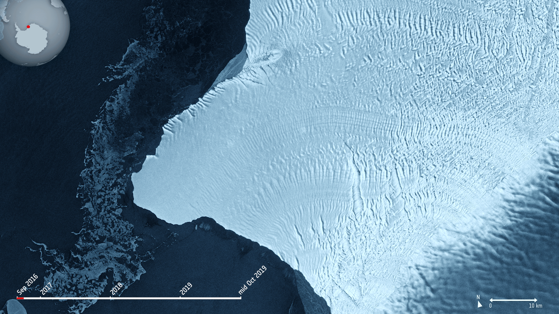 Image:
The Copernicus Sentinel-1 mission takes us over cracks in the Brunt ice shelf, which lies in the Weddell Sea sector of Antarctica.
Using radar images from the Copernicus Sentinel-1 mission, the animation shows the evolution of two ice fractures from September 2016 until mid-October 2019. The large chasm running northwards is called Chasm 1, while the split extending eastwards is referred to as the Halloween Crack.
First spotted on 31 October 2016, the Halloween crack runs from an area known as McDonald Ice Rumples – which is where the underside of the floating ice sheet is grounded on the shallow seabed. This pinning point slows the flow of ice and crumples the ice surface into waves.
Chasm 1 on the other hand has been in place for over 25 years. It was previously stable for many years, but in 2012, it was noticed that the dormant crack started extending northwards.
Now, Chasm 1 and Halloween crack are only separated by a few kilometres. When they meet, an iceberg about the size of Greater London will break off. The two lengthening fractures have been set to intersect for years – it’s only a matter of time for the two to meet.
The Brunt shelf has been monitored by glaciologists for decades and is constantly changing. Early maps from the 1970s indicate that the ice shelf used to be a mass of small icebergs welded together by sea ice.
Calving is a natural process of the life cycle of ice shelves. Although the iceberg is of a considerable size, it will not be the largest of icebergs to calve in Antarctica. In 2017, a chunk of Larsen C broke off spawning one of the largest icebergs on record and changing the outline of the Antarctic Peninsula.
Ice shelf movement is very unpredictable. Routine monitoring from satellites offer unprecedented views of events happening in remote regions, and show how ice shelves are responding to changes in ice dynamics, air and ocean temperatures.
As an advanced radar mission, Copernicus Sentinel-1 can image the surface of Earth through cloud and rain and regardless of whether it is day or night. This makes it an ideal mission for monitoring the polar regions, which are in darkness during the winter months and for monitoring tropical forests, which are typically shrouded by cloud.
This image is also featured on the Earth from Space video programme.
Earth from Space: Halloween crack
1.11.2019 10:00 Video:
00:02:57
Video:
00:02:57
In this week's edition of the Earth from Space programme, the Copernicus Sentinel-1 mission takes us over cracks in the Brunt ice shelf, which lies in the Weddell Sea sector of Antarctica.
See also Halloween crack to download the image.
SMOS 10 years in orbit
31.10.2019 10:00 Video:
00:04:57
Video:
00:04:57
SMOS has been in orbit for a decade. This remarkable satellite has not only exceeded its planned life in orbit, but also surpassed its original scientific goals. It was designed to deliver data on soil moisture and ocean salinity which are both crucial components of Earth’s water cycle. By consistently mapping these variables, SMOS is not only advancing our understanding of the water cycle and the exchange processes between Earth’s surface and the atmosphere, but is also helping to improve weather forecasts and contributing to climate research as well as contributing to a growing number of practical everyday applications.
SMOS 10 years in orbit
31.10.2019 10:00
Video:
00:04:57
SMOS has been in orbit for a decade. This remarkable satellite has not only exceeded its planned life in orbit, but also surpassed its original scientific goals. It was designed to deliver data on soil moisture and ocean salinity which are both crucial components of Earth’s water cycle. By consistently mapping these variables, SMOS is not only advancing our understanding of the water cycle and the exchange processes between Earth’s surface and the atmosphere, but is also helping to improve weather forecasts and contributing to climate research as well as contributing to a growing number of practical everyday applications.
Tracking Typhoon Hagibis from space
29.10.2019 15:00
Hagibis was the biggest typhoon to hit Japan in decades. With extreme events like this likely to increase in number and in severity as a consequence of climate change, satellites are playing an increasingly important role in understanding and tracking huge storms.
Contract seals deal for Biomass satellite’s ride into space
28.10.2019 9:52
Today, ESA and Arianespace signed a contract that secures the launch of the Earth Explorer Biomass satellite. With liftoff scheduled for 2022 on a Vega launch vehicle from French Guiana, this new mission is another step closer to mapping the amount of carbon stored in forests and how it changes over time though deforestation, for example.
Is Earth on fire?
25.10.2019 10:35
Wildfires have been making headlines again this month, with multiple fires burning in Lebanon and California, but these are just some of the many fires 2019 has seen. Fires in the Amazon sparked a global outcry this summer, but fires have also been blazing in the Arctic, France, Greece, Indonesia as well as many other areas in the world.
Earth from Space: Leelanau Peninsula
25.10.2019 10:00 Video:
00:02:51
Video:
00:02:51
In this week's edition of the Earth from Space programme, the Copernicus Sentinel-2 missiontakes us over the Leelanau Peninsula on the northwest coast of Northern Michigan, US.
See also Leelanau Peninsula, US to download the image.
Earth from Space: Leelanau Peninsula
25.10.2019 10:00
Video:
00:02:51
In this week's edition of the Earth from Space programme, the Copernicus Sentinel-2 missiontakes us over the Leelanau Peninsula on the northwest coast of Northern Michigan, US.
See also Leelanau Peninsula, US to download the image.
Leelanau Peninsula, US
25.10.2019 10:00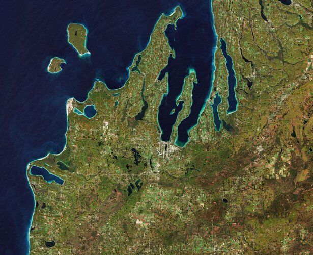 Image:
The Copernicus Sentinel-2 mission takes us over the Leelanau Peninsula on the northwest coast of Northern Michigan, US.
The region is shaped by rolling hills, large inland lakes shaped by glaciers around 20 000 years ago which form the basis for great farmland. The body of water that surrounds the peninsula is Lake Michigan, one of the five Great Lakes of North America and the only one located entirely within the US.
In the image, the bright turquoise in the water shows sediments, algae and chlorophyll in the shallower waters along the shore. The greener colours visible in Lake Leelanau to the north, Platte Lake to the west, and several inland bodies of water are due to a combination of a high chlorophyll and plant content.
The Sleeping Bear Dunes Lakeshore extend for around 55 km along the coast of the peninsula, and is visible in light brown. The name comes from an Ojibwa legend in which a mother bear and her two cubs swim across the lake trying to escape a forest fire. The two cubs are said to have disappeared in the process, and the mother bear waited for weeks for them to re-surface before finally falling asleep and never waking. Touched by her suffering, a powerful spirit is said to have covered her with sand, and raised the two cubs above the water, creating the North and South Manitou islands, visible north of the peninsula.
A more realistic explanation of the creation of the Sleeping Bear Dunes is geology. During the last Ice Age, glaciers spread southwards from Canada burying this area under sheets of ice. During the process, piles of sand and rock were deposited in the area. When the ice retreated and melted, it left the hilly terrain that exists along the lake today. The area is popular for hiking and climbing.
This image, which was captured on 18 October 2018, is also featured on the Earth from Space video programme.