


![]()


ESA Observing the Earth 
zdroje zpráv:
Earth from Space
20.10.2016 15:25
Join us Friday, 21 October, at 10:00 CEST for the ‘Earth from Space’ video programme. This week features Nepal’s capital city, Kathmandu, and part of the Himalayan foothills
Earth’s most active volcanoes on satellite watch
20.10.2016 15:15
As hundreds flee lava and ash spewed from Mexico’s Colima volcano, its continuing eruption is being tracked not only by ground instruments but also from space. Starting last month, Colima is one of 22 active volcanoes worldwide being monitored by satellites.
Earth from Space
20.10.2016 14:00Join us Friday, 21 October, at 10:00 CEST for the ‘Earth from Space’ video programme. This week features Nepal’s capital city, Kathmandu, and part of the Himalayan foothills
Sentinel-3A Earth colour data released
20.10.2016 11:50
Today, the Copernicus Sentinel-3A satellite has taken another step towards being fully ‘operational’ as the first data from its Ocean and Land Colour Instrument are made available to monitor the health of our planet.
SMOS on speed
14.10.2016 13:00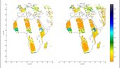
While ESA’s water mission was built to advance our understanding of Earth, it continues to show how well it’s suited to delivering information for numerous applications that improve everyday life. Taking this a step further, soil moisture data products are now available within three hours of measurement, which is essential for many applications.
Vatnajökull
14.10.2016 10:05
Earth observation image of the week: Iceland’s Vatnajökull glacier and Holuhraun lava field, also featured on the Earth from Space video programme
Earth from Space
13.10.2016 14:25Join us Friday, 14 October, at 10:00 CEST for the ‘Earth from Space’ video programme. Discover Iceland’s Vatnajökull glacier in this week’s edition
The way ahead
10.10.2016 14:15
After his first 100 days as Director of Earth Observation Programmes, Josef Aschbacher joins the Earth from Space video programme to discuss the future of Earth observation in ESA
Earth from Space
10.10.2016 14:10Join us Tuesday, 11 October, at 14:00 CEST as ESA’s new Director of Earth Observation Programmes, Josef Aschbacher, joins the show to discuss the future of Earth observation in ESA
Eye of the storm
7.10.2016 16:35
This image, from the Copernicus Sentinel-3A satellite, shows the temperature at the top of Hurricane Matthew as it approached the US this morning
What are TEPs?
7.10.2016 12:00
Discover the Thematic Exploitation Platforms – or TEPs – which provide a virtual work environment to exploit complex satellite data
Shanghai
7.10.2016 10:05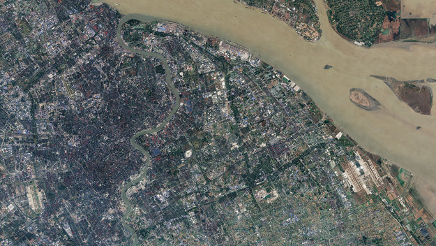
Earth observation image of the week: a Sentinel-2 image of Shanghai, also featured in the 200th edition of the Earth from Space video programme
Business in the ever-changing digital world
6.10.2016 15:15
In an era of profound digital transformation, business leaders and IT experts are convening at ESA’s mission control in Darmstadt, Germany, today for the first SAP Digital Leaders’ Summit.
Earth from Space
6.10.2016 14:00Join us Friday, 7 October, at 10:00 CEST for the 200th ‘Earth from Space’ video programme. This week features a Sentinel-2 image of Shanghai
Sustainable cities
4.10.2016 14:00
Four climate change and urban development experts join the show to discuss how satellite data can be used to promote sustainable cities
Magnetic oceans and electric Earth
3.10.2016 18:30
Oceans might not be thought of as magnetic, but they make a tiny contribution to our planet’s protective magnetic shield. Remarkably, ESA’s Swarm satellites have not only measured this extremely faint field, but have also led to new discoveries about the electrical nature of inner Earth.
Earth from Space
3.10.2016 14:00Join us Tuesday, 4 October, at 14:00 CEST as four climate change and urban development experts join the show to discuss how satellite data can be used to promote sustainable cities
Ouarkziz crater
30.9.2016 10:05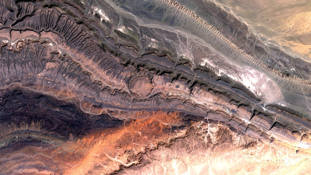
Earth observation image of the week: a Sentinel-2A image of the Anti-Atlas mountains in Western Algeria
Satellites help understand what fuels the twilight zone
27.9.2016 9:35
The deep, dark twilight zone a kilometre down in the ocean is home to most of the world’s fish, but how they get enough food has largely been a mystery. Now, thanks to satellites and floating sensors, scientists have worked out how much energy is being pumped to the depths.
Alakol Lake
23.9.2016 10:05
Earth observation image of the week: a Sentinel-2 image of Kazakhstan’s Alakol Lake, also featured on the Earth from Space video programme
Earth from Space
22.9.2016 15:08Join us Friday, 23 September, at 10:00 CEST for the ‘Earth from Space’ video programme. This week features Kazakhstan’s Alakol Lake
Blanketed in smoke
20.9.2016 10:14As numerous wildfires continue to burn in Siberia, the Copernicus Sentinel-3A satellite has captured images of huge smoke plumes stretching 2000 km
Fine wine app wins top prize at App Camp
19.9.2016 16:20
An app that uses satellite data to evaluate the quality of wine took home the top prize at this year’s Space App Camp at ESA’s centre in Frascati, Italy.
Fine wine app wins top prize at App Camp
19.9.2016 16:20An app that uses satellite data to evaluate the quality of wine took home the top prize at this year’s Space App Camp at ESA’s centre in Frascati, Italy.
App Camp wrap-up
16.9.2016 14:30
Follow the presentation of projects from this year’s Space App Camp via live webstream at 08:30–12:30 CEST on 19 September, with a special presentation from astronaut Luca Parmitano
Radar mission live
16.9.2016 10:44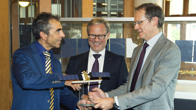
Launched in April, the Copernicus Sentinel-1B satellite has now been commissioned and ready to supply radar images of Earth
Poyang Lake
16.9.2016 10:04
Earth observation image of the week: China's Poyang Lake in radar vision
Earth from Space
15.9.2016 14:20Join us Friday, 16 September, at 10:00 CEST for the ‘Earth from Space’ video programme. This week features Poyang Lake in China – home to the finless porpoise
Cool scene for MetOp-C
15.9.2016 10:40
Technology image of the week: A complex cryogenic structure set up in advance of testing Europe's next weather satellite
Revisit Open Science
14.9.2016 17:00
Watch the replay videos of the EO Open Science 2016 conference held at ESA’s ESRIN establishment in Italy 12–14 September
Madeira scarred
14.9.2016 9:59
The recent devastation brought by wildfires to the beautiful Portuguese island of Madeira is all too clear in these images from Sentinel-2A
Estonia signs up to Sentinel agreement
13.9.2016 14:00
ESA and Enterprise Estonia have signed an arrangement that gives one of ESA’s newest Member States access to data from the Copernicus Sentinel satellites.
Estonia signs up to Sentinel agreement
13.9.2016 14:00ESA and Enterprise Estonia have signed an arrangement that gives one of ESA’s newest Member States access to data from the Copernicus Sentinel satellites.
Open Science
9.9.2016 14:15Follow the EO Open Science 2016 conference via live webstream from ESA’s ESRIN establishment in Italy 12–14 September. Live coverage continues Wednesday at 9:30 CEST
Open Science
9.9.2016 14:15Follow the EO Open Science 2016 conference via live webstream from ESA’s ESRIN establishment in Italy 12–14 September. Live coverage begins Monday at 9:00 CEST
Open Science
9.9.2016 14:15Follow the EO Open Science 2016 conference via live webstream from ESA’s ESRIN establishment in Italy 12–14 September. Live coverage continues Tuesday at 9:30 CEST
Open Science
9.9.2016 14:00Follow the EO Open Science 2016 conference via live webstream from ESA’s ESRIN establishment in Italy 12–14 September. Live coverage begins Monday at 9:00 CEST
Barents bloom
9.9.2016 10:01
Earth observation image of the week: a Sentinel-2A image of a plankton bloom in the Barents Sea
Earth from Space
8.9.2016 15:00Join us Friday, 9 September, at 10:00 CEST for the ‘Earth from Space’ video programme. This week features the watercolour swirls of a plankton bloom in the Barents Sea
Vega to launch ESA’s wind mission
7.9.2016 9:30
Today, ESA and Arianespace signed a contract to secure the launch of the Aeolus satellite. With this milestone, a better understanding of Earth’s winds is another step closer.
Vega to launch ESA’s wind mission
7.9.2016 9:30Today, ESA and Arianespace signed a contract to secure the launch of the Aeolus satellite. With this milestone, a better understanding of Earth’s winds is another step closer.
Arctic and Space
5.9.2016 14:45
As the Arctic is developed, how can space help safeguard this fragile environment? Follow the Arctic and Space workshop at the Finnish Meteorological Institute on 6 September. Livestream starts at 06:00 GMT (08:00 CEST)
Upsala Glacier
2.9.2016 10:00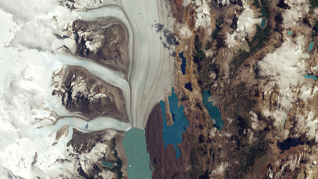
Earth observation image of the week: a Sentinel-2A image of Argentina’s Upsala Glacier, which has retreated more than 3 km in the past 15 years
Earth from Space
1.9.2016 14:00The ‘Earth from Space’ video programme is back! Join us Friday, 2 September, at 10:00 CEST and discover Argentina’s Upsala Glacier
Intro to EO: sign up today
1.9.2016 9:00
Sign up for a free online course that provides an introduction to optical satellite Earth observation. The five-week Future Learn course begins on 12 September
Copernicus Sentinel-1A satellite hit by space particle
31.8.2016 16:00
ESA engineers have discovered that a solar panel on the Copernicus Sentinel-1A satellite was hit by a millimetre-size particle in orbit on 23 August. Thanks to onboard cameras, ground controllers were able to identify the affected area. So far, there has been no effect on the satellite’s routine operations.
Copernicus Sentinel-1A satellite hit by space particle
31.8.2016 16:00ESA engineers have discovered that a solar panel on the Copernicus Sentinel-1A satellite was hit by a millimetre-size particle in orbit on 23 August. Thanks to onboard cameras, ground controllers were able to identify the affected area. So far, there has been no effect on the satellite’s routine operations.
Sentinel-1 provides new insight into Italy’s earthquake
29.8.2016 16:52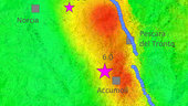
On 24 August, an earthquake struck central Italy, claiming at least 290 lives and causing widespread damage. Satellite images are being used to help emergency aid organisations, while scientists have begun to analyse ground movement.
Sentinel-1 provides new insight into Italy’s earthquake
29.8.2016 16:52On 24 August, an earthquake struck central Italy, claiming at least 290 lives and causing widespread damage. Satellite images are being used to help emergency aid organisations, while scientists have begun to analyse ground movement.
First satellite-based wildlife monitoring tool for airports
29.8.2016 12:24
Wildlife habitats close to airports pose a serious risk to safety at takeoff and landing. Thanks to ESA, a new service lets airports use satellites to identify and manage these areas.
First satellite-based wildlife monitoring tool for airports
29.8.2016 12:24Wildlife habitats close to airports pose a serious risk to safety at takeoff and landing. Thanks to ESA, a new service lets airports use satellites to identify and manage these areas.
Land shifts in Italy
26.8.2016 17:45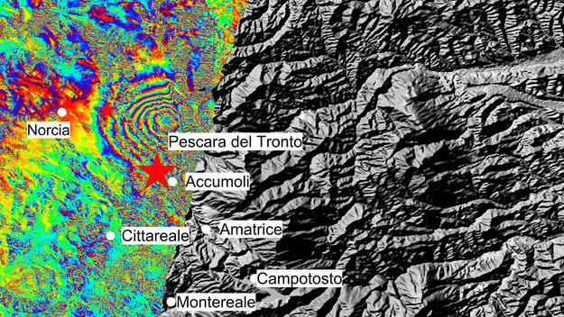
The Sentinel-1A satellite has given us a picture of the ground deformation caused by the 24 August earthquake in Italy
Bridging the Bosphorus
26.8.2016 10:42
Sentinel-2A captured the progress of Turkey’s Third Bosphorus Bridge, which opens today
FLEX takes on mutants
25.8.2016 17:00
Because a plant isn’t green doesn’t mean it can’t photosynthesise as well as its more usual counterpart, but when measured by satellites, these non-green varieties skew results on plant health. FLEX is different. Experiments using ‘mutants’ show that colour won’t be an obstacle in this new mission’s task of mapping plant health from space.
Touch on climate
9.8.2016 10:30
Discover our planet's changing climate through the eyes of satellites with Climate from Space, a new iPad App featuring interactive maps and video interviews with top scientists
Summer school shines
8.8.2016 14:10
Young Earth scientists from all over the world have gathered for their two-week summer school course at ESA’s ESRIN centre for Earth observation in Frascati, Italy.
Summer school shines
8.8.2016 14:10Young scientists from all over the world have gathered for their two-week summer school course at ESA’s ESRIN centre for Earth observation in Frascati, Italy.
Aladin wind probe ready for Aeolus
2.8.2016 16:30
It has been years in the making, but one of the trickiest pieces of space technology ever developed is finally ready to join its satellite for launch by the end of next year. With this milestone, we are another step closer to a better understanding of Earth’s winds.
Iranian painting
29.7.2016 10:00
Earth observation image of the week: A Sentinel-2A image of northeastern Iran
Earth from Space
28.7.2016 14:00Join us Friday, 29 July, at 10:00 CEST for the ‘Earth from Space’ video programme. This week features a Sentinel-2A image of northeastern Iran
SMOS tracks Pacific fresh water pools
27.7.2016 13:56
ESA’s SMOS satellite has found a rise in fresh water in the tropical Pacific Ocean during last year’s El Niño event.
Sand and sea
27.7.2016 12:00The Sentinel-3A satellite recently caught this image of a dust storm blowing east across the Red Sea
Sand and sea
27.7.2016 12:00
The Sentinel-3A satellite recently caught this image of a dust storm blowing east across the Red Sea
CryoSat sets new standard for measuring sea levels
26.7.2016 14:40
Trying to measure sea levels around rugged coastlines is not always an easy task. ESA’s CryoSat satellite is making a difference with its radar altimeter.
Tonga
22.7.2016 10:00
Earth observation image of the week: Tonga’s Tongatapu island in the southern Pacific Ocean
Earth from Space
21.7.2016 14:25Join us Friday, 22 July, at 10:00 CEST for the ‘Earth from Space’ video programme. This week features a Sentinel-2A image of Tonga’s Tongatapu island
Chilly summer for Sentinel-2B
18.7.2016 10:37
While most of us may be looking forward to spending some time in the sunshine this summer, the Sentinel-2B satellite is being subjected to the extreme cold of space to make sure it is fit for life in orbit.
Sundarbans web
15.7.2016 10:00
Earth observation image of the week: A Sentinel-2A image of Sundarbans, Bangladesh
Earth from Space
14.7.2016 14:00Join us Friday, 15 July, at 10:00 CEST for the ‘Earth from Space’ video programme. This week features a Sentinel-2A image of the Sundarbans, in Bangladesh
Europe’s workhorse Sentinel ready for action
13.7.2016 14:20
Getting the bigger picture on the health of our planet drew another step closer today as Europe’s Sentinel-3A satellite was handed over to Eumetsat for operations.
CryoSat reveals recent Greenland ice loss
12.7.2016 13:30
In the most detailed picture to date, information from ESA’s CryoSat satellite reveals how melting ice in Greenland has recently contributed twice as much to sea-level rise as the prior two decades.
ESA’s Dragon cooperation with China extended to 2020
8.7.2016 10:39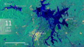
ESA and China have launched the fourth phase of the collaborative Dragon programme in Wuhan City, on the Yangtze River, which recently experienced major floods witnessed by Europe’s Sentinel-1 satellite.
Malaspina Glacier
8.7.2016 10:00
Earth observation image of the week: The world’s largest ‘piedmont’ glacier
Earth from Space
7.7.2016 14:40Join us Friday, 8 July, at 10:00 CEST for the ‘Earth from Space’ video programme. This week features a Sentinel-2A image of the Malaspina Glacier in Alaska
A study in scarlet
6.7.2016 12:00
Technology image of the week: ESA minisatellite Proba-V images the Netherlands and its vegetation in false colour
Looking out for coral bleaching
1.7.2016 12:00
The EOMAP aquatic remote sensing company, together with partners at the Remote Sensing Research Centre of Queensland University and the Great Barrier Reef Foundation, are developing new methods to monitor and detect coral bleaching events using Europe’s Sentinel-2A satellite.
Mount St Helens
1.7.2016 10:00
Earth observation image of the week: An active volcano in the US state of Washington
Earth from Space
30.6.2016 14:55Join us Friday, 1 July, at 10:00 CEST for the ‘Earth from Space’ video programme. This week features a Sentinel-2A image of Mount St Helens in the US
Sentinels for Regions
27.6.2016 9:08
Discover how Sentinel data support local and regional authorities by following an event live from the European Parliament in Brussels at 15:00–18:00 CEST on 28 June
Mediterranean wonders
24.6.2016 10:00
Earth observation image of the week: A Sentinel-3A image of various countries in the Mediterranean Sea
Earth from Space
23.6.2016 14:00Join us Friday, 24 June, at 10:00 CEST for the ‘Earth from Space’ video programme. This week features a Sentinel-3A image of the Mediterranean
Floating Piers
22.6.2016 17:05
The Sentinel-2A satellite captured creation of the ‘Floating Piers’ installation on Lake Iseo by the Bulgarian–American artist, Christo
Sentinel space testing
22.6.2016 16:55
Technology image of the week: Sentinel-2B being lowered into Europe's largest vacuum chamber for testing
Sentinel space testing
22.6.2016 15:30Technology image of the week: Sentinel-2B being lowered into Europe's largest vacuum chamber for testing
Sentinel-1 satellites combine radar vision
22.6.2016 11:30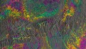
The twin Sentinel-1 satellites have – for the first time – combined to show their capability for revealing even small deformations in Earth’s surface.
Southern Tibetan Plateau
17.6.2016 10:00
Earth observation image of the week: A Sentinel-2A image of the Tibetan Plateau
Earth from Space
16.6.2016 14:00Join us Friday, 17 June, at 10:00 CEST for the ‘Earth from Space’ video programme. This week features a Sentinel-2A image of the southern Tibetan Plateau
New ESA Director of Earth Observation
14.6.2016 13:10
At a restricted meeting of the ESA Council held in Paris today Mr Josef Aschbacher was appointed as ESA Director of Earth Observation.
New ESA Director of Earth Observation
14.6.2016 13:10
At a restricted meeting of the ESA Council held in Paris today Mr Josef Aschbacher was appointed as ESA Director of Earth Observation.
Sentinel-1B timelapse
13.6.2016 14:30
A look back on the preparations for the 25 April liftoff of Sentinel-1B
Calling App developers
10.6.2016 14:00
Sign up for the next ESA Space App Camp to create innovative Apps using satellite data
United Kingdom
10.6.2016 10:00
Earth observation image of the week: A Sentinel-3A image of the United Kingdom
Earth from Space
9.6.2016 14:30Join us Friday, 10 June, at 10:00 CEST for the ‘Earth from Space’ video programme. This week features a Sentinel-3A image of the UK
Estonia’s first contract with ESA focuses on ocean health
7.6.2016 13:41Estonia has been awarded its first contract since becoming an ESA Member State in 2015. Over the next three years, scientists from Estonia’s Tartu Observatory will head an international team to ensure that Sentinel-3’s measurements of ocean colour are of the highest quality possible.
Monitoring pipelines from space
6.6.2016 10:35
Dutch company Orbital Eye has developed a service that uses satellites to monitor gas and oil pipelines. A major African pipeline operator has already signed up for the service.
Southern Maine
3.6.2016 10:00
Earth observation image of the week: A Sentinel-2A image of Maine and New Hampshire, USA
Earth from Space
2.6.2016 14:00Join us Friday, 3 June, at 10:00 CEST for the ‘Earth from Space’ video programme. This week, Sentinel-2 takes us over Maine and New Hampshire in the northeast US
First EDRS laser image
1.6.2016 12:20
ESA today unveiled the first Sentinel-1 satellite images sent via the European Data Relay System’s world-leading laser technology in high orbit
Sentinels in the fields
1.6.2016 10:54
The unprecedented frequency of Sentinel observations capture rapid changes in agricultural production from national to field scale, serving as a major support for environmental monitoring and agricultural subsidy control.
Mapping that sinking feeling
1.6.2016 10:50For a low-lying, densely populated country like the Netherlands, monitoring subsidence is critical. Until recently, tiny displacements in the ground beneath our feet couldn’t be mapped nationally but, thanks to the Sentinel-1 mission, this is now possible.
Fort McMurray fires
31.5.2016 14:46
The Sentinel-2 satellite recently captured this image of wildfires in Canada’s Alberta province
Chile's salt flat
27.5.2016 10:00
Earth observation image of the week: A Sentinel-2A image of Salar de Atacama, Chile
Sentinel-1 helping Cyclone Roanu relief
26.5.2016 15:00
Cyclone Roanu has claimed over 100 lives in Sri Lanka and Bangladesh, and has left tens of thousands in need of aid. Officials are looking to the sky for information on flooded areas to analyse the cyclone’s aftermath and support emergency response activities.
Earth from Space
26.5.2016 14:00Join us Friday, 27 May, at 10:00 CEST for the ‘Earth from Space’ video programme. This week features a Sentinel-2A image of Chile
Call for media
26.5.2016 9:39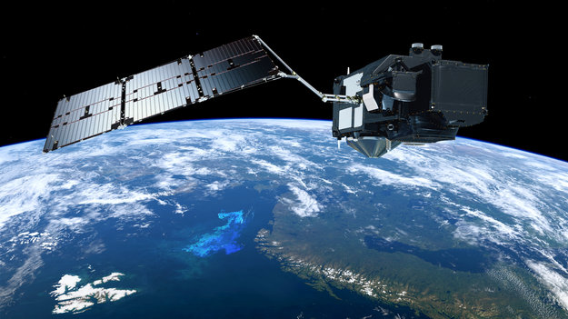
Media representatives are invited to the European Space Solutions Conference on 30 May in The Hague, Netherlands, to hear about the first results from Sentinel-3A
Sentinel-1A spots potential oil slick from missing EgyptAir plane
20.5.2016 13:30
The Sentinel-1A radar satellite has detected a potential oil slick in the eastern Mediterranean Sea – in the same area where EgyptAir flight MS804 disappeared early yesterday morning on its way from Paris to Cairo.
Rub’ al Khali Desert
20.5.2016 10:00
Earth observation image of the week: A Sentinel-2A image of the Rub’ al Khali desert
Canadian fires tracked by satellites
19.5.2016 16:58
Wildfires have been raging in Canada’s Alberta province for nearly three weeks, causing widespread destruction and forcing thousands of people from their homes. As the blaze grows and shifts, satellites are tracking its movement.
Sun glitter reveals coastal waves
19.5.2016 15:45
Sentinel-2A is demonstrating how it can be used to help forecast ocean waves around our coasts: sunlight reflected from the water surface reveals complex waves as they encounter the coastline and seafloor off the tip of Dorre Island, Western Australia.
Earth from Space
19.5.2016 14:00Join us Friday, 20 May, at 10:00 CEST for the ‘Earth from Space’ video programme. This week features a Sentinel-2A image of the Rub’ al Khali desert
African mosaic
18.5.2016 12:49
Images from Sentinel-2A over the last five months have been used to create a remarkable cloud-free view of Africa
Simulating Tropomi
13.5.2016 14:00
Presented at this week’s Living Planet Symposium, this image shows how the Sentinel-5P satellite will improve air-quality forecasts
Living Planet 2016
13.5.2016 13:30
Selected highlights of the Living Planet Symposium in Prague, 9-13 May
Methane and carbon dioxide on the rise
13.5.2016 12:00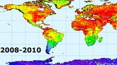
Satellite readings show that atmospheric methane and carbon dioxide are continuing to increase despite global efforts to reduce emissions.
Earth from Space
13.5.2016 9:00
René Forsberg joins the programme at the Living Planet Symposium in Prague to discuss collecting gravity data at the South Pole to support GOCE
Complex data made easy
12.5.2016 14:52
While the growing volume information from satellites observing Earth offers a unique opportunity for science and applications, it is sometimes difficult to make sure these complex data streams are exploited to their full potential. ESA is addressing this challenge with ‘Thematic Exploitation Platforms’.
Water for crops
12.5.2016 12:00
By providing information on soil moisture around plant roots, ESA’s SMOS satellite is helping to forecast crop yield and monitor drought
Earth from Space
12.5.2016 9:00
Noel Gourmelen joins the programme at the Living Planet Symposium in Prague to discuss a new way of processing CryoSat data over ice sheets
From petabytes to pictures
11.5.2016 14:35
Thousands of scientists are at the Living Planet Symposium in Prague this week to present the latest findings on our changing planet. Between the mountains of data coming from multiple satellites and the high level of expertise needed to translate them into useful information, the results are not always easy to understand.