


zprávy
zdroje zpráv:New website puts climate in your hands
21.10.2020 16:55 ESA Observing the Earth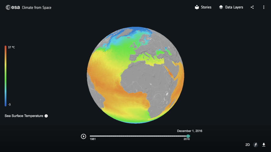
Witness the changing planet through the eye of Earth-orbiting satellites with ‘Climate from Space,’ a new interactive website developed by ESA.
Bentley Systems spouští iTwin Platform pro tzv. digitální dvojčata
21.10.2020 15:19 GeoBusinessFirma Bentley Systems, která v předchozích dnech uspořádala virtuální konference Year In Infrastructure, informovala o spuštění iTwin Platform. iTwin Platform navazuje na dosavadní pracovní postupy, spojené s digitálními dvojčaty, Design Review a Design Validation. Viceprezident pro iTwin Platform, Adam Klatzkin popisuje ve zprávě, co se povedlo vytvořit. Launching iTwin Platform This is a brand-new platform-as-a-service […]
The post Bentley Systems spouští iTwin Platform pro tzv. digitální dvojčata appeared first on GeoBusiness.
Verze 14.75 reaguje na změny ČÚZK
21.10.2020 15:17 GEPROPublikovali jsme verze 14.75 našich produktů MISYS, MISYS-WEB – licenční server, KOKEŠ, Geoportál GEPRO i PROLAND.… >>
GSA vydává technologickou zprávu o vývoji GNSS
21.10.2020 14:42 GeoBusinessEvropská agentura pro GNSS (GSA) vydala svoji třetí GNSS Technology Report 2020 – zpráva obsahuje analýzu a nejnovější trendy ve vývoji GNSS technogií. GNSS průmysl se postupně dostává do mainstreamu. Na trhu je celá řada multifrekvenčních přijímačů, které mohou získávat signál ze čtyř globálních navigačních družicových systémů (Global Navigation Satellite System, GNSS) s více než […]
The post GSA vydává technologickou zprávu o vývoji GNSS appeared first on GeoBusiness.
výběrového řízení na služební místo odborný referent KP Havlíčkův Brod
21.10.2020 13:34 ČÚZK - předpisy a opatření Katastrální úřad pro Vysočinu zveřejnil novou aktualitu: Oznámení o vyhlášení výběrového řízení na služební místo odborný referent v oddělení dokumentace KN Katastrálního pracoviště Havlíčkův Brod.výběrového řízení na služební místo odborný referent KP Havlíčkův Brod
21.10.2020 13:34 ČÚZK /Urady/Katastralni-urady/Katastralni-urady/Katastralni-urad-pro-Vysocinu/O-uradu/Aktuality/vyberoveho-rizeni-na-sluzebni-misto-odborny-refereodborný referent - dokumentace KN KP Havlíčkův Brod
21.10.2020 12:41 ČÚZK - volná místa Katastrální úřad pro Vysočinu Katastrální pracoviště Havlíčkův Brod vypisuje výběrové řízení na místo odborný referent - dokumentace KN KP Havlíčkův Brododborný referent - dokumentace KN KP Havlíčkův Brod
21.10.2020 12:41 ČÚZK /Urady/Katastralni-urady/Katastralni-urady/Katastralni-urad-pro-Vysocinu/Uredni-deska/Oznameni-a-jina-uredni-sdeleni/Volna-mista/DMS/odborny-referent-dokumentace-KN-KP-Havlickuv-Broodborný referent - dokumentace KN KP Havlíčkův Brod
21.10.2020 12:41 ČÚZK - předpisy a opatření Katastrální úřad pro Vysočinu Katastrální pracoviště Havlíčkův Brodvypisuje výběrové řízení na místo
odborný referent - dokumentace KN KP Havlíčkův Brod
From #EUSpace to farm to fork: the journey from space applications, to smart farming, and down to your plate
21.10.2020 12:32 European GNSS Agency
#EUSpace is closer than you think. By relying on the powerful synergies of Galileo, EGNOS and Copernicus, EU farmers can increase crop productivity, optimize resources and reduce their environmental footprint. The food on your plate relies on EUspace services.
Grassland and cropland together make up 39 % of Europe's land cover. Today’s agricultural landscape is facing the challenge of producing enough food to respond to a rapid world population growth, while reducing its environmental footprint in terms of emissions, soil degradation, utilisation of water, fertilizers and pesticides.
To tackle these challenges more and more farmers and agriculturists across the European Union resort to precision agriculture. Dutch precision farmer, Jacob Van den Borne took us on a virtual tour of his farm where he explained why space is a true enabler in the sector.
The Van den Borne potato farm, just off the Belgian-Dutch borders, is one of the most technologically advanced farms in the EU. Jacob Van den Borne firstly ventured into the field of precision farming in 2006 and ever since he has not stopped investing in new technologies enabling him to sustainably cultivate his land. The state-of-the-art potato farm utilizes Galileo, EGNOS and Copernicus (Sentinel satellites data) as well as aerial footage from drones and big data on daily basis in order to optimize water and fertilizer usage and increase crop yield.
'According to our calculations there’s always around 10-15% fertilizer/pesticide overlap during spraying. With the accurate guidance of EGNSS we are able to minimize this overlap down to 1%' said Van den Borne.
With around 70% of new GNSS tractors using Galileo and another 97% using EGNOS, the EU space technology is becoming the preferred technology for precision farming in Europe. Galileo’s capability of combining signals from other constellations (GPS, GLONASS) and with corrections coming from EGNOS, signal interruptions caused by foliage are reduced to almost zero.
'Some years ago, when seeding the field with my tractor my signal would get interrupted especially in areas with trees. The antennas I was using back then were only GPS + GLONASS enabled. Now with the additional Galileo satellites I have full signal reception even under the trees,' commented Van den Borne when asked about Galileo’s signal robustness.
GSA H2020 Funded Projects: GREENPATROL and GALIRUMI
The virtual farm visit was also an opportunity to showcase the innovative character of H2020 funded Galirumi and Green Patrol projects and the added value they bring to the agribusiness sector.
GREENPATROL is a European precision farming project aiming at developing an innovative and efficient robotic solution for Integrated Pest Management in Greenhouses. The robot uses the most sophisticated signals of satellites especially the multiple-frequencies E1, E5 of Galileo.
The EU project GALIRUMI is aiming to deliver robot weeding for herbicide-free weed control in dairy farming. Robotic weeding will reduce the environmental impact of dairy farming by eliminating herbicide use and thus reducing exposure of farm workers to herbicides. It will also help dairy farmers to switch to organic production, thereby contributing to an increase in production of organically produced milk and better incomes for farmers.
Secretary General of CEMA Jerome Bandry as well as Max Schulman chair of Central Union of Agricultural Producers and Forest Owners also joined the visit and the discussion, stressing the importance of raising awareness about the available resources and make it accessible to all farmers across the EU.
With eyes fixed on the EU Green Deal, the European Commission has set out policies and legislations such as the Farm to Fork Strategy to support Member States in achieving food sustainability. Synergies between the EU satellite systems can support precision farming and lead to a sustainable EU agriculture, mitigating the environmental footprint and enabling the digitisation of agri-governmental controls within the Common Agricultural Policy (CAP).
GSA is linking the benefits of EUSpace to a wide range of applications and sectors, to tackle current and future challenges such as a sustainable farming system that is able to provide food while reducing it environmental footprint. While space is an invisible infrastructure, it does have an impact on your plate.
Here’s a recap of the virtual visit.
Media note: This feature can be republished without charge provided the European GNSS Agency (GSA) is acknowledged as the source at the top or the bottom of the story. You must request permission before you use any of the photographs on the site. If you republish, we would be grateful if you could link back to the GSA website (http://www.gsa.europa.eu).
From #EUSpace to Farm to fork: the journey from space applications, to smart farming, and down to your plate.
21.10.2020 12:32 European GNSS Agency#EUSpace is closer than you think. By relying on the powerful synergies of Galileo, EGNOS and Copernicus, EU farmers can increase crop productivity, optimize resources and reduce their environmental footprint. The food on your plate relies on EUspace services.
Grassland and cropland together make up 39 % of Europe's land cover. Today’s agricultural landscape is facing the challenge of producing enough food to respond to a rapid world population growth, while reducing its environmental footprint in terms of emissions, soil degradation, utilisation of water, fertilizers and pesticides.
To tackle these challenges more and more farmers and agriculturists across the European Union resort to precision agriculture. Dutch precision farmer, Jacob Van den Borne took us on a virtual tour of his farm on 3 September 2020 where he explained why space is a true enabler in the sector.
The Van den Borne potato farm, just off the Belgian-Dutch borders, is one of the most technologically advanced potato farms in the EU. Jacob Van den Borne firstly ventured into the field of precision farming in 2006 and ever since he has not stopped investing in new technologies enabling him to sustainably cultivate his land. The state-of-the-art potato farm utilizes Galileo, EGNOS and Copernicus (Sentinel satellites data) as well as aerial footage from drones and big data on daily basis in order to optimize water and fertilizer consumption and increase crop yield.
'According to our calculations there’s always around 10-15% fertilizer/pesticide overlap during spraying. With the accurate guidance of EGNSS we are able to minimize this overlap down to 1%' said Van den Borne.
With around 70% of new GNSS tractors using Galileo and another 97% using EGNOS, the EU space technology is becoming the preferred low-cost entry technology for precision farming in Europe. Galileo’s capability of combining signals from other constellations (GPS, GLONASS) and with corrections coming from EGNOS, signal interruptions caused by foliage are reduced to almost zero.
'Some years ago, when seeding the field with my tractor my signal would get interrupted especially in areas with increased forestry. The antennas I was using back then were only GPS + GLONASS enabled. Now with the additional Galileo satellites I have full signal reception even under the trees,' commented Van den Borne when asked about Galileo’s signal robustness.
GSA H2020 Funded Projects: GREENPATROL and GALIRUMI
The virtual farm visit was also an opportunity to showcase the innovative character of H2020 funded Galirumi and Green Patrol projects and the added value they bring to the agribusiness sector.
GREENPATROL is a European precision farming project aiming at developing an innovative and efficient robotic solution for Integrated Pest Management in Greenhouses. The robot uses the most sophisticated signals of satellites especially the multiple-frequencies E1, E5 and E6 by Galileo.
The EU project GALIRUMI is aiming to deliver robot weeding for herbicide-free weed control in dairy farming. Robotic weeding will reduce the environmental impact of dairy farming by eliminating herbicide use and reducing exposure of farm workers to herbicides. It will also help dairy farmers to switch to organic production, thereby contributing to an increase in production of organically produced milk and better incomes for farmers.
Secretary General of CEMA Jerome Bandry as well as Max Schulman chair of Central Union of Agricultural Producers and Forest Owners also joined the visit and the discussion, stressing the importance of raising awareness about the available resources and make it accessible to all farmers across the EU.
With eyes fixed on the EU Green Deal, the European Commission has set out policies and legislations such as the Farm to Fork Strategy to support Member States in achieving food sustainability. Synergies between the EU satellite systems can support precision farming and lead to a sustainable EU agriculture, mitigating the environmental footprint and enabling the digitisation of agri-governmental controls within the Common Agricultural Policy (CAP).
GSA is linking the benefits of EUSpace to a wide range of applications and sectors, to tackle current and future challenges such as a sustainable farming system that is able to provide food while reducing it environmental footprint. While space is an invisible infrastructure, it does have an impact on your plate.
Here’s a recap of the virtual visit.
Media note: This feature can be republished without charge provided the European GNSS Agency (GSA) is acknowledged as the source at the top or the bottom of the story. You must request permission before you use any of the photographs on the site. If you republish, we would be grateful if you could link back to the GSA website (http://www.gsa.europa.eu).
From #EUSpace to farm to fork: the journey from space applications, to smart farming, and down to your plate
21.10.2020 12:32 European GNSS Agency#EUSpace is closer than you think. By relying on the powerful synergies of Galileo, EGNOS and Copernicus, EU farmers can increase crop productivity, optimize resources and reduce their environmental footprint. The food on your plate relies on EUspace services.
Grassland and cropland together make up 39 % of Europe's land cover. Today’s agricultural landscape is facing the challenge of producing enough food to respond to a rapid world population growth, while reducing its environmental footprint in terms of emissions, soil degradation, utilisation of water, fertilizers and pesticides.
To tackle these challenges more and more farmers and agriculturists across the European Union resort to precision agriculture. Dutch precision farmer, Jacob Van den Borne took us on a virtual tour of his farm where he explained why space is a true enabler in the sector.
The Van den Borne farm, just off the Belgian-Dutch borders, is one of the most technologically advanced farms in the EU. Jacob Van den Borne firstly ventured into the field of precision farming in 2006 and ever since he has not stopped investing in new technologies enabling him to sustainably cultivate his land. The state-of-the-art potato farm utilizes Galileo, EGNOS and Copernicus (Sentinel satellites data) as well as aerial footage from drones and big data on daily basis in order to optimize water and fertilizer usage and increase crop yield.
'According to our calculations there’s always around 10-15% fertilizer/pesticide overlap during spraying. With the accurate guidance of EGNSS we are able to minimize this overlap down to 1%' said Van den Borne.
With around 70% of new GNSS tractors using Galileo and another 97% using EGNOS, the EU space technology is becoming the preferred technology for precision farming in Europe. Galileo’s capability of combining signals from other constellations (GPS, GLONASS) and with corrections coming from EGNOS, service provision becomes as seamless than ever.
'Some years ago, when seeding the field with my tractor my signal would get interrupted especially in areas with trees. The antennas I was using back then were only GPS + GLONASS enabled. Now with the additional Galileo satellites I have full signal reception even under the trees,' commented Van den Borne when asked about Galileo’s signal robustness.
GSA H2020 Funded Projects: GREENPATROL and GALIRUMI
The virtual farm visit was also an opportunity to showcase the innovative character of H2020 funded Galirumi and Green Patrol projects and the added value they bring to the agribusiness sector.
GREENPATROL is a European precision farming project aiming at developing an innovative and efficient robotic solution for Integrated Pest Management in Greenhouses. The robot uses the most sophisticated signals of satellites especially the multiple-frequencies E1, E5 of Galileo.
The EU project GALIRUMI is aiming to deliver robot weeding for herbicide-free weed control in dairy farming. Robotic weeding will reduce the environmental impact of dairy farming by eliminating herbicide use and thus reducing exposure of farm workers to herbicides. It will also help dairy farmers to switch to organic production, thereby contributing to an increase in production of organically produced milk and better incomes for farmers.
Secretary General of CEMA Jerome Bandry as well as Max Schulman chair of Central Union of Agricultural Producers and Forest Owners also joined the visit and the discussion, stressing the importance of raising awareness about the available resources and make it accessible to all farmers across the EU.
With eyes fixed on the EU Green Deal, the European Commission has set out policies and legislations such as the Farm to Fork Strategy to support Member States in achieving food sustainability. Synergies between the EU satellite systems can support precision farming and lead to a sustainable EU agriculture, mitigating the environmental footprint and enabling the digitisation of agri-governmental controls within the Common Agricultural Policy (CAP).
GSA is linking the benefits of EUSpace to a wide range of applications and sectors, to tackle current and future challenges such as a sustainable farming system that is able to provide food while reducing it environmental footprint. While space is an invisible infrastructure, it does have an impact on your plate.
Here’s a recap of the virtual visit.
Media note: This feature can be republished without charge provided the European GNSS Agency (GSA) is acknowledged as the source at the top or the bottom of the story. You must request permission before you use any of the photographs on the site. If you republish, we would be grateful if you could link back to the GSA website (http://www.gsa.europa.eu).
From #EUSpace to Farm to fork: the journey from space applications, to smart farming, and down to your plate.
21.10.2020 12:32 European GNSS Agency
#EUSpace is closer than you think. By relying on the powerful synergies of Galileo, EGNOS and Copernicus, EU farmers can increase crop productivity, optimize resources and reduce their environmental footprint. The food on your plate relies on EUspace services.
Grassland and cropland together make up 39 % of Europe's land cover. Today’s agricultural landscape is facing the challenge of producing enough food to respond to a rapid world population growth, while reducing its environmental footprint in terms of emissions, soil degradation, utilisation of water, fertilizers and pesticides.
To tackle these challenges more and more farmers and agriculturists across the European Union resort to precision agriculture. Dutch precision farmer, Jacob Van den Borne took us on a virtual tour of his farm on 3 September 2020 where he explained why space is a true enabler in the sector.
The Van den Borne potato farm, just off the Belgian-Dutch borders, is one of the most technologically advanced potato farms in the EU. Jacob Van den Borne firstly ventured into the field of precision farming in 2006 and ever since he has not stopped investing in new technologies enabling him to sustainably cultivate his land. The state-of-the-art potato farm utilizes Galileo, EGNOS and Copernicus (Sentinel satellites data) as well as aerial footage from drones and big data on daily basis in order to optimize water and fertilizer consumption and increase crop yield.
'According to our calculations there’s always around 10-15% fertilizer/pesticide overlap during spraying. With the accurate guidance of EGNSS we are able to minimize this overlap down to 1%' said Van den Borne.
With around 70% of new GNSS tractors using Galileo and another 97% using EGNOS, the EU space technology is becoming the preferred low-cost entry technology for precision farming in Europe. Galileo’s capability of combining signals from other constellations (GPS, GLONASS) and with corrections coming from EGNOS, signal interruptions caused by foliage are reduced to almost zero.
'Some years ago, when seeding the field with my tractor my signal would get interrupted especially in areas with increased forestry. The antennas I was using back then were only GPS + GLONASS enabled. Now with the additional Galileo satellites I have full signal reception even under the trees,' commented Van den Borne when asked about Galileo’s signal robustness.
GSA H2020 Funded Projects: GREENPATROL and GALIRUMI
The virtual farm visit was also an opportunity to showcase the innovative character of H2020 funded Galirumi and Green Patrol projects and the added value they bring to the agribusiness sector.
GREENPATROL is a European precision farming project aiming at developing an innovative and efficient robotic solution for Integrated Pest Management in Greenhouses. The robot uses the most sophisticated signals of satellites especially the multiple-frequencies E1, E5 and E6 by Galileo.
The EU project GALIRUMI is aiming to deliver robot weeding for herbicide-free weed control in dairy farming. Robotic weeding will reduce the environmental impact of dairy farming by eliminating herbicide use and reducing exposure of farm workers to herbicides. It will also help dairy farmers to switch to organic production, thereby contributing to an increase in production of organically produced milk and better incomes for farmers.
Secretary General of CEMA Jerome Bandry as well as Max Schulman chair of Central Union of Agricultural Producers and Forest Owners also joined the visit and the discussion, stressing the importance of raising awareness about the available resources and make it accessible to all farmers across the EU.
With eyes fixed on the EU Green Deal, the European Commission has set out policies and legislations such as the Farm to Fork Strategy to support Member States in achieving food sustainability. Synergies between the EU satellite systems can support precision farming and lead to a sustainable EU agriculture, mitigating the environmental footprint and enabling the digitisation of agri-governmental controls within the Common Agricultural Policy (CAP).
GSA is linking the benefits of EUSpace to a wide range of applications and sectors, to tackle current and future challenges such as a sustainable farming system that is able to provide food while reducing it environmental footprint. While space is an invisible infrastructure, it does have an impact on your plate.
Here’s a recap of the virtual visit.
Media note: This feature can be republished without charge provided the European GNSS Agency (GSA) is acknowledged as the source at the top or the bottom of the story. You must request permission before you use any of the photographs on the site. If you republish, we would be grateful if you could link back to the GSA website (http://www.gsa.europa.eu).
Vrchní referent/rada v oddělení aktualizace GI KN na Katastrálním pracovišti Brno - město
21.10.2020 12:16 ČÚZK - volná místa Katastrální úřad pro Jihomoravský kraj Katastrální pracoviště Brno-město vypisuje výběrové řízení na místo Vrchní referent/rada v oddělení aktualizace GI KN na Katastrálním pracovišti Brno - městoVrchní referent/rada v oddělení aktualizace GI KN na Katastrálním pracovišti Brno - město
21.10.2020 12:16 ČÚZK /Urady/Katastralni-urady/Katastralni-urady/Katastralni-urad-pro-Jihomoravsky-kraj/Uredni-deska/Oznameni-a-jina-uredni-sdeleni/Volna-mista/DMS/Vrchni-referent-rada-v-oddeleni-aktualizace-GI-KNVrchní referent/rada v oddělení aktualizace GI KN na Katastrálním pracovišti Brno - město
21.10.2020 12:16 ČÚZK - předpisy a opatření Katastrální úřad pro Jihomoravský kraj Katastrální pracoviště Brno-městovypisuje výběrové řízení na místo
Vrchní referent/rada v oddělení aktualizace GI KN na Katastrálním pracovišti Brno - město
Odborný referent v oddělení právním č.2 na Katastrálním pracovišti Brno - město
21.10.2020 12:14 ČÚZK /Urady/Katastralni-urady/Katastralni-urady/Katastralni-urad-pro-Jihomoravsky-kraj/Uredni-deska/Oznameni-a-jina-uredni-sdeleni/Volna-mista/DMS/Odborny-referent-v-oddeleni-pravnim-c-2-na-KatastrOdborný referent v oddělení dokumentace KN na Katastrálním pracovišti Brno - město
21.10.2020 12:14 ČÚZK - volná místa Katastrální úřad pro Jihomoravský kraj vypisuje výběrové řízení na místo Odborný referent v oddělení dokumentace KN na Katastrálním pracovišti Brno - městoOdborný referent v oddělení právním č.2 na Katastrálním pracovišti Brno - město
21.10.2020 12:14 ČÚZK - předpisy a opatření Katastrální úřad pro Jihomoravský kraj Katastrální pracoviště Brno-městovypisuje výběrové řízení na místo
Odborný referent v oddělení právním č.2 na Katastrálním pracovišti Brno - město
Odborný referent v oddělení právním č.2 na Katastrálním pracovišti Brno - město
21.10.2020 12:14 ČÚZK - volná místa Katastrální úřad pro Jihomoravský kraj Katastrální pracoviště Brno-město vypisuje výběrové řízení na místo Odborný referent v oddělení právním č.2 na Katastrálním pracovišti Brno - městoOdborný referent v oddělení dokumentace KN na Katastrálním pracovišti Brno - město
21.10.2020 12:14 ČÚZK /Urady/Katastralni-urady/Katastralni-urady/Katastralni-urad-pro-Jihomoravsky-kraj/Uredni-deska/Oznameni-a-jina-uredni-sdeleni/Volna-mista/DMS/Odborny-referent-v-oddeleni-pravnim-c-2-na-KatastrOdborný referent v oddělení dokumentace KN na Katastrálním pracovišti Brno - město
21.10.2020 12:14 ČÚZK - předpisy a opatření Katastrální úřad pro Jihomoravský krajvypisuje výběrové řízení na místo
Odborný referent v oddělení dokumentace KN na Katastrálním pracovišti Brno - město
Rada/odborný rada v oddělení právním č.1 na katastrálním pracovišti Brno - město
21.10.2020 12:11 ČÚZK - volná místa Katastrální úřad pro Jihomoravský kraj Katastrální pracoviště Brno-město vypisuje výběrové řízení na místo Rada/odborný rada v oddělení právním č.1 na katastrálním pracovišti Brno - městoRada/odborný rada v oddělení právním č.1 na katastrálním pracovišti Brno - město
21.10.2020 12:11 ČÚZK /Urady/Katastralni-urady/Katastralni-urady/Katastralni-urad-pro-Jihomoravsky-kraj/Uredni-deska/Oznameni-a-jina-uredni-sdeleni/Volna-mista/DMS/Rada-odborny-rada-v-oddeleni-pravnim-c-1-na-katastRada/odborný rada v oddělení právním č.1 na katastrálním pracovišti Brno - město
21.10.2020 12:11 ČÚZK - předpisy a opatření Katastrální úřad pro Jihomoravský kraj Katastrální pracoviště Brno-městovypisuje výběrové řízení na místo
Rada/odborný rada v oddělení právním č.1 na katastrálním pracovišti Brno - město
Odborný referent v oddělení aktualizace PI KN č.2 na Katastrálním pracovišti Brno - venkov
21.10.2020 12:07 ČÚZK - volná místa Katastrální úřad pro Jihomoravský kraj Katastrální pracoviště Brno-venkov vypisuje výběrové řízení na místo Odborný referent v oddělení aktualizace PI KN č.2 na Katastrálním pracovišti Brno - venkovOdborný referent v oddělení aktualizace PI KN č.2 na Katastrálním pracovišti Brno - venkov
21.10.2020 12:07 ČÚZK /Urady/Katastralni-urady/Katastralni-urady/Katastralni-urad-pro-Jihomoravsky-kraj/Uredni-deska/Oznameni-a-jina-uredni-sdeleni/Volna-mista/DMS/Odborny-referent-v-oddeleni-aktualizace-PI-KN-c-2Odborný referent v oddělení aktualizace PI KN č.2 na Katastrálním pracovišti Brno - venkov
21.10.2020 12:07 ČÚZK - předpisy a opatření Katastrální úřad pro Jihomoravský kraj Katastrální pracoviště Brno-venkovvypisuje výběrové řízení na místo
Odborný referent v oddělení aktualizace PI KN č.2 na Katastrálním pracovišti Brno - venkov
Odborný referent v oddělení právním na Katastrálním pracovišti Brno - venkov
21.10.2020 12:05 ČÚZK /Urady/Katastralni-urady/Katastralni-urady/Katastralni-urad-pro-Jihomoravsky-kraj/Uredni-deska/Oznameni-a-jina-uredni-sdeleni/Volna-mista/DMS/Odborny-referent-v-oddeleni-pravnim-na-KatastralniOdborný referent v oddělení právním na Katastrálním pracovišti Brno - venkov
21.10.2020 12:05 ČÚZK - volná místa Katastrální úřad pro Jihomoravský kraj Katastrální pracoviště Brno-venkov vypisuje výběrové řízení na místo Odborný referent v oddělení právním na Katastrálním pracovišti Brno - venkovOdborný referent v oddělení právním na Katastrálním pracovišti Brno - venkov
21.10.2020 12:05 ČÚZK - předpisy a opatření Katastrální úřad pro Jihomoravský kraj Katastrální pracoviště Brno-venkovvypisuje výběrové řízení na místo
Odborný referent v oddělení právním na Katastrálním pracovišti Brno - venkov
Odborný referent v oddělení právních vztahů k nemovitostem na Katastrálním pracovišti Vyškov
21.10.2020 11:58 ČÚZK /Urady/Katastralni-urady/Katastralni-urady/Katastralni-urad-pro-Jihomoravsky-kraj/Uredni-deska/Oznameni-a-jina-uredni-sdeleni/Volna-mista/DMS/Odborny-referent-v-oddeleni-pravnich-vztahu-k-nemoOdborný referent v oddělení právních vztahů k nemovitostem na Katastrálním pracovišti Vyškov
21.10.2020 11:58 ČÚZK - volná místa Katastrální úřad pro Jihomoravský kraj Katastrální pracoviště Vyškov vypisuje výběrové řízení na místo Odborný referent v oddělení právních vztahů k nemovitostem na Katastrálním pracovišti VyškovOdborný referent v oddělení právních vztahů k nemovitostem na Katastrálním pracovišti Vyškov
21.10.2020 11:58 ČÚZK - předpisy a opatření Katastrální úřad pro Jihomoravský kraj Katastrální pracoviště Vyškovvypisuje výběrové řízení na místo
Odborný referent v oddělení právních vztahů k nemovitostem na Katastrálním pracovišti Vyškov
Rada/odborný rada v oddělení aktualizace KN na Katastrálním pracovišti Vyškov
21.10.2020 11:54 ČÚZK - volná místa Katastrální úřad pro Jihomoravský kraj Katastrální pracoviště Vyškov vypisuje výběrové řízení na místo Rada/odborný rada v oddělení aktualizace KN na Katastrálním pracovišti VyškovRada/odborný rada v oddělení aktualizace KN na Katastrálním pracovišti Vyškov
21.10.2020 11:54 ČÚZK - předpisy a opatření Katastrální úřad pro Jihomoravský kraj Katastrální pracoviště Vyškovvypisuje výběrové řízení na místo
Rada/odborný rada v oddělení aktualizace KN na Katastrálním pracovišti Vyškov
Rada/odborný rada v oddělení aktualizace KN na Katastrálním pracovišti Vyškov
21.10.2020 11:54 ČÚZK /Urady/Katastralni-urady/Katastralni-urady/Katastralni-urad-pro-Jihomoravsky-kraj/Uredni-deska/Oznameni-a-jina-uredni-sdeleni/Volna-mista/DMS/Rada-odborny-rada-v-oddeleni-aktualizace-KN-na-KatRada/odborný rada-vedoucí oddělení právních vztahů k nemovitostem na Katastrálním pracovišti Vyškov
21.10.2020 11:27 ČÚZK /Urady/Katastralni-urady/Katastralni-urady/Katastralni-urad-pro-Jihomoravsky-kraj/Uredni-deska/Oznameni-a-jina-uredni-sdeleni/Volna-mista/DMS/Rada-odborny-rada-vedouci-oddeleni-pravnich-vztahuRada/odborný rada-vedoucí oddělení právních vztahů k nemovitostem na Katastrálním pracovišti Vyškov
21.10.2020 11:27 ČÚZK - volná místa Katastrální úřad pro Jihomoravský kraj Katastrální pracoviště Vyškov vypisuje výběrové řízení na místo Rada/odborný rada-vedoucí oddělení právních vztahů k nemovitostem na Katastrálním pracovišti VyškovRada/odborný rada-vedoucí oddělení právních vztahů k nemovitostem na Katastrálním pracovišti Vyškov
21.10.2020 11:27 ČÚZK - předpisy a opatření Katastrální úřad pro Jihomoravský kraj Katastrální pracoviště Vyškovvypisuje výběrové řízení na místo
Rada/odborný rada-vedoucí oddělení právních vztahů k nemovitostem na Katastrálním pracovišti Vyškov
Rada/odborný rada – správce informačních a komunikačních technologií v technickém odboru Katastrální
21.10.2020 10:43 ČÚZK - volná místa Katastrální úřad pro Moravskoslezský kraj technický odbor vypisuje výběrové řízení na místo Rada/odborný rada – správce informačních a komunikačních technologií v technickém odboru KatastrálníRada/odborný rada – správce informačních a komunikačních technologií v technickém odboru Katastrální
21.10.2020 10:43 ČÚZK /Urady/Katastralni-urady/Katastralni-urady/Katastralni-urad-pro-Moravskoslezsky-kraj/Uredni-deska/Oznameni-a-jina-uredni-sdeleni/Volna-mista/DMS/Rada-odborny-rada-–-spravce-informacnich-a-komunikRada/odborný rada – správce informačních a komunikačních technologií v technickém odboru Katastrální
21.10.2020 10:43 ČÚZK - předpisy a opatření Katastrální úřad pro Moravskoslezský kraj technický odborvypisuje výběrové řízení na místo
Rada/odborný rada – správce informačních a komunikačních technologií v technickém odboru Katastrálního úřadu pro Moravskoslezský kraj
Odborný referent/vrchní referent – obnova katastrálního operátu na Katastrálním pracovišti Opava
21.10.2020 10:38 ČÚZK - volná místa Katastrální úřad pro Moravskoslezský kraj Katastrální pracoviště Opava vypisuje výběrové řízení na místo Odborný referent/vrchní referent – obnova katastrálního operátu na Katastrálním pracovišti OpavaOdborný referent/vrchní referent – obnova katastrálního operátu na Katastrálním pracovišti Opava
21.10.2020 10:38 ČÚZK - předpisy a opatření Katastrální úřad pro Moravskoslezský kraj Katastrální pracoviště Opavavypisuje výběrové řízení na místo
Odborný referent/vrchní referent – obnova katastrálního operátu na Katastrálním pracovišti Opava
Odborný referent/vrchní referent – obnova katastrálního operátu na Katastrálním pracovišti Opava
21.10.2020 10:38 ČÚZK /Urady/Katastralni-urady/Katastralni-urady/Katastralni-urad-pro-Moravskoslezsky-kraj/Uredni-deska/Oznameni-a-jina-uredni-sdeleni/Volna-mista/DMS/Odborny-referent-vrchni-referent-–-obnova-katastraVrchní referent/rada – řízení o opravě chyby v SPI
21.10.2020 10:34 ČÚZK - volná místa Katastrální úřad pro Moravskoslezský kraj Katastrální pracoviště Frýdek-Místek vypisuje výběrové řízení na místo Vrchní referent/rada – řízení o opravě chyby v SPIVrchní referent/rada – řízení o opravě chyby v SPI
21.10.2020 10:34 ČÚZK - předpisy a opatření Katastrální úřad pro Moravskoslezský kraj Katastrální pracoviště Frýdek-Místekvypisuje výběrové řízení na místo
Vrchní referent/rada – řízení o opravě chyby v SPI
Vrchní referent/rada – řízení o opravě chyby v SPI
21.10.2020 10:34 ČÚZK /Urady/Katastralni-urady/Katastralni-urady/Katastralni-urad-pro-Moravskoslezsky-kraj/Uredni-deska/Oznameni-a-jina-uredni-sdeleni/Volna-mista/DMS/Vrchni-referent-rada-–-rizeni-o-oprave-chyby-v-SPIvrchní referent/rada – obnova katastrálního operátu na Katastrálním pracovišti Bruntál
21.10.2020 10:29 ČÚZK - volná místa Katastrální úřad pro Moravskoslezský kraj Katastrální pracoviště Bruntál vypisuje výběrové řízení na místo vrchní referent/rada – obnova katastrálního operátu na Katastrálním pracovišti Bruntálvrchní referent/rada – obnova katastrálního operátu na Katastrálním pracovišti Bruntál
21.10.2020 10:29 ČÚZK - předpisy a opatření Katastrální úřad pro Moravskoslezský kraj Katastrální pracoviště Bruntálvypisuje výběrové řízení na místo
vrchní referent/rada – obnova katastrálního operátu na Katastrálním pracovišti Bruntál
vrchní referent/rada – obnova katastrálního operátu na Katastrálním pracovišti Bruntál
21.10.2020 10:29 ČÚZK /Urady/Katastralni-urady/Katastralni-urady/Katastralni-urad-pro-Moravskoslezsky-kraj/Uredni-deska/Oznameni-a-jina-uredni-sdeleni/Volna-mista/DMS/vrchni-referent-rada-–-obnova-katastralniho-operatJak se měří vysokorychlostní železnice
21.10.2020 9:23 Hrdlička Dvoucentimetrový pixel usnadňuje geodetické práce na budoucích vysokorychlostních tratíchKnihovna uzavřena! [Knihovna geografie, byTopic]
21.10.2020 0:00 Katedra aplikované geoinformatiky a kartografie Přf UK Z důvodu usnesení vlády z 21. 10. 2020 o přijetí krizového opatření v souvislosti s šířením onemocnění koronaviru COVID-19 bylo rozhodnuto o uzavření Knihovny geografie od 21. 10. 2020 do odvolání. Zaměstnanci i studenti mají možnost se dohodnout s knihovníky e-mailem na (výjimečných) výpůjčkách dokumentů. Ty budou poskytnuty mimo knihovny (v předsálí, v podatelně nebo u vrátnice). Výpůjčky končící mezi 22.10. až 3.11. budou prodlouženy do 18.11. 2020.Byl uvolněn SolidCAM 2020 SP3
21.10.2020 0:00 SolidVision Byl uvolněn SolidCAM 2020 SP3 HF2. Uživatelé s aktivní předplacenou údržbou si mohou nejaktuálnější verzi stáhnout na stránkách SolidCAM.ZRUŠENO - Nové veřejné nabídky pozemků pro oprávněné osoby podle zákona č. 229/1991 Sb.
21.10.2020 0:00 Státní pozemkový úřadKnihovna uzavřena! [Knihovna geografie, byTopic]
21.10.2020 0:00 Katedra aplikované geoinformatiky a kartografie Přf UK Z důvodu usnesení vlády z 21. 10. 2020 o přijetí krizového opatření v souvislosti s šířením onemocnění koronaviru COVID-19 bylo rozhodnuto o uzavření Knihovny geografie od 21. 10. 2020 do odvolání. Zaměstnanci i studenti mají možnost se dohodnout s knihovníky e-mailem na výjimečných výpůjčkách dokumentů. Ty budou poskytnuty mimo knihovny (v předsálí, v podatelně nebo u vrátnice). Výpůjčky končící mezi 22.10. až 3.11. budou prodlouženy do 18.11. 2020.ZRUŠENO - Nové veřejné nabídky pozemků pro oprávněné osoby podle zákona č. 229/1991 Sb.
21.10.2020 0:00 Státní pozemkový úřadByl uvolněn SolidCAM 2020 SP3
21.10.2020 0:00 SolidVision Byl uvolněn SolidCAM 2020 SP3 HF2. Uživatelé s aktivní předplacenou údržbou si mohou nejaktuálnější verzi stáhnout na stránkách SolidCAM.East West Aeronautical Expansion Leads to $200M Investment Offer
20.10.2020 20:18 GISCafe.com Webcasts-Webinars EWA gains momentum in air the cargo logistics business in partnership with Indonesian InvestorsBOSTON, Oct. 20, 2020 — (PRNewswire) — …
Kratos Introduces OpenSpace™ Platform Supporting Dynamic, Software-Defined Satellite Ground Systems
20.10.2020 20:18 GISCafe.com Webcasts-Webinars SAN DIEGO, Oct. 20, 2020 (GLOBE NEWSWIRE) -- Kratos Defense & Security Solutions, Inc. (Nasdaq: KTOS), a leading National Security Solutions …Volansi Launches Commercial Drone Delivery Program To Deliver Cold Chain Medicines In Rural North Carolina
20.10.2020 20:18 GISCafe.com Webcasts-Webinars SAN FRANCISCO, Oct. 20, 2020 — (PRNewswire) — Volansi, Inc., the leader in vertical take-off and landing (VTOL), middle-mile drone …uAvionix Files FAA TSO Application for World’s First Certified Drone Transponder
20.10.2020 17:42 GISCafe.com Webcasts-Webinars BIGFORK, Mont. — (BUSINESS WIRE) — October 20, 2020 —Today, uAvionix Corporation announced it has filed a Technical Standard …
Velodyne Lidar Calls for Action to Improve Pedestrian Safety
20.10.2020 17:42 GISCafe.com Webcasts-Webinars New Velodyne White Paper Shows How Advanced Driver Assistance Systems (ADAS) Can be Improved to Reduce Nighttime Dangers to PedestriansSAN JOSE, …
Discovery International Geophysics Selects Draganfly to Integrate Multi-Rotor Magnetic Field Surveying Systems
20.10.2020 17:42 GISCafe.com Webcasts-Webinars Saskatoon, Saskatchewan, Oct. 20, 2020 (GLOBE NEWSWIRE) -- Draganfly Inc. (OTCQB: DFLYF) (CSE: DFLY) (FSE: 3U8) (“Draganfly” or the …Novara GeoSolutions is Now CHA Integrated Solutions
20.10.2020 17:41 GISCafe.com Webcasts-Webinars Asset Management and Geospatial-based Software Firm RebrandsALBANY, N.Y., Oct. 20, 2020 — (PRNewswire) — Novara GeoSolutions, a …
Digital Twin Consortium Announces Liaison with buildingSMART
20.10.2020 17:41 GISCafe.com Webcasts-Webinars Advancing digital twin technologies in infrastructure and building industriesBOSTON, Oct. 20, 2020 — (PRNewswire) —
BOSTON, Oct. 20, …
AI Startup EarthDefine Announces Expansion of its Building Footprint Geocoding and On-Demand Property Information
20.10.2020 17:41 GISCafe.com Webcasts-Webinars "Latest Expansion will Improve Quoting Accuracy, Risk Rating and Claims Response for Commercial and Residential Property Insurers"REDMOND, Wash., …
Bluestone Portfolio Company, Continental Mapping Consultants, LLC, Announces Acquisition of TSG Solutions, Inc.
20.10.2020 17:41 GISCafe.com Webcasts-Webinars - Enhances company's National Security capabilities and intellectual property portfolioMCLEAN, Va., Oct. 20, 2020 — (PRNewswire) — …
McKim & Creed Acquires Water Loss Recovery and Control Firm
20.10.2020 17:41 GISCafe.com Webcasts-Webinars WILMINGTON, N.C., Oct. 20, 2020 — (PRNewswire) — McKim & Creed, Inc., one of the largest engineering, geomatics (surveying) …GisOnline – chytré mapy od TopGis
20.10.2020 14:13 TopGis Od vydání první verze našeho GisOnline uběhl již nějaký pátek. Od té doby v něm přibylo mnoho funkcí a dat. Co to je GisOnline a jaké funkce má jsme shrnuli v našem novém videu.To je TopGis 2020
20.10.2020 14:13 TopGis To je TopGis 2020 – do jednoho krátkého videa jsme napěchovali naši špičkovou techniku pro sběr geografických dat a ukázky vybraných produktů i zadání našich zákazníků která řešíme. Za vším samozřejmě stojí naše plošná data celé ČR a naši zkušení lidé. Svůj majetek už můžete spravovat přímo v námi vyvíjené webové mapové aplikaci. Co naVirtual Infoshare 2020: EGNSS at the core of the space-tech entrepreneurship
20.10.2020 12:16 European GNSS Agency
Infoshare, the biggest tech conference in Central and Eastern Europe went virtual and global this year, with more than 7500 participants joining the online streaming. The GSA joined both the virtual exhibition and the start-up expo, together with eight European start-ups showcasing their innovative EGNSS-based solutions
With a long track record of boosting entrepreneurship and space-tech innovation, the GSA selected eight GNSS-enthusiast start-ups to join the exhibition and to promote their Galileo solutions. The eight European businesses harnessing EGNSS in agriculture, safety at work, localization, aviation, high accuracy, maritime and rail were offered to present their solutions to companies and investors during the two last weeks of September 2020.
With a line-up of 191 speakers, thought-leaders, innovators and business-disrupters, the global conference showcased next-gen technologies, produced 8 300 minutes of content and connected hundreds of companies, investors and start-ups from 71 countries. Six days of live streaming included a rich agenda featuring project presentations, matchmaking sessions, workshops and lectures for developers, marketers, executives, investors and more. The programme was divided into several stages on various topics, such as business leadership, marketing strategies, apps development, and success stories including solutions using space synergies.
EGNSS solutions in bloom
Companies and projects like 3daerospace, MSDK research, Argeo, GroundEye, Flamingo GNSS, Galileonaut, Delate and PRNS, all featured at this year’s Infoshare, showing how EUspace can ignite business and entrepreneurship.
Read this: Recommendations for Areas of Focus and Innovation Funding for EGNSS R&D
3daerospace: through its business solution DeVines, the startup addresses common problems for winemakers and vineyards. The solution combines the assets of Galileo for precise geolocation and artificial intelligence for precise monitoring. Grape growers and winemakers will be able to use a mobile app or a web-based map to visualise the digital vineyard map, assisting producers in their winemaking management at different stages: workforce management, vines supervision and vineyard management.
MSDK research’s LifeGuard is an end-to-end, modular solution for worker safety. It consists of an AI-powered analytics platform and a wearable sensor-kit that warns workers of any potential dangers and notifies the monitoring team should any accidents happen. This Galileo-enabled app also assists with contact tracing, aid management, or hazard interpolation.
ARGEO is a proximity marketing mobile app which merges the powerful technologies of augmented reality and Galileo’s added value in geolocation. ARGEO generates a drive-to-store flow combining gamification and online interaction with an offline finish.
GroundEye by Blue Dot Solutions is a technology platform to monitor mobile ground infrastructure at airports. The system is characterized by Galileo’s added precision, fast and reliable data transmission, a wide range of data analysis together with a collision and threat detection system, and the highest level of security.
FLAMINGO GNSS is a direct response to the emerging trend for higher accuracy positioning on mass market devices. FLAMINGO Project has created a positioning service with enhanced accuracy for smartphones, lowering accuracy from approximately 3 to 10 metres down to 0.5 to 1 metre, enhancing user experience and creating new and improved features in location-based apps, while allowing the development of next-gen location-based apps.
GalileoNaut is a mobile application that helps sailors find their way inside a port or a marina. It allows the harbour master's office to assign a docking place to a boat entering the harbour, and, by combining Galileo’s positioning and mapping, the sailor can be safely guided to the docking place without any assistance from the harbour master’s office. GalileoNaut considers the location given by the smartphone and uses a surface algorithm to compute the trajectory to the docking place. Thus, sailors can be reassured in their boating practices and particularly in the approach phase of a port, which is the most delicate phase.
Delate is the first app that uses Galileo to turn train delays into discounts on products and services. The App offer benefits for train commuters, and at the same time, it functions as a marketing tool for the brands present on the app's marketplace.
PRNS (Precision Navigation Systems) has recently launched Stargate RTK worldwide GNSS correction service that provides access to tailored GNSS correction streams in real-time for precise positioning, tracking, and navigation to unlimited devices.
The GSA goes virtual
Before the end of the year, there is one more opportunity to learn, exchange and network with EUSpace leaders and innovators. That’s right, the #EUSpaceWeek 2020, December 7-11, the biggest space event of the year, is going virtual and global, connecting all key EUSpace actors, stakeholders, decision-makers, industry and user-communities. The programme is packed with key notes, programme updates, user consultations, investors fora, and networking opportunities, to join pre-register here.
Media note: This feature can be republished without charge provided the European GNSS Agency (GSA) is acknowledged as the source at the top or the bottom of the story. You must request permission before you use any of the photographs on the site. If you republish, we would be grateful if you could link back to the GSA website (http://www.gsa.europa.eu).
Virtual Infoshare 2020: EGNSS at the core of the space-tech entrepreneurship
20.10.2020 12:16 European GNSS AgencyInfoshare, the biggest tech conference in Central and Eastern Europe went virtual and global this year, with more than 7500 participants joining the online streaming. The GSA joined both the virtual exhibition and the start-up expo, together with eight European start-ups showcasing their innovative EGNSS-based solutions
With a long track record of boosting entrepreneurship and space-tech innovation, the GSA selected eight GNSS-enthusiast start-ups to join the exhibition and to promote their Galileo solutions. The eight European businesses harnessing EGNSS in agriculture, safety at work, localization, aviation, high accuracy, maritime and rail were offered to present their solutions to companies and investors during the two last weeks of September 2020.
With a line-up of 191 speakers, thought-leaders, innovators and business-disrupters, the global conference showcased next-gen technologies, produced 8 300 minutes of content and connected hundreds of companies, investors and start-ups from 71 countries. Six days of live streaming included a rich agenda featuring project presentations, matchmaking sessions, workshops and lectures for developers, marketers, executives, investors and more. The programme was divided into several stages on various topics, such as business leadership, marketing strategies, apps development, and success stories including solutions using space synergies.
EGNSS solutions in bloom
Companies and projects like 3daerospace, MSDK research, Argeo, GroundEye, Flamingo GNSS, Galileonaut, Delate and PRNS, all featured at this year’s Infoshare, showing how EUspace can ignite business and entrepreneurship.
Read this: Recommendations for Areas of Focus and Innovation Funding for EGNSS R&D
3daerospace: through its business solution DeVines, the startup addresses common problems for winemakers and vineyards. The solution combines the assets of Galileo for precise geolocation and artificial intelligence for precise monitoring. Grape growers and winemakers will be able to use a mobile app or a web-based map to visualise the digital vineyard map, assisting producers in their winemaking management at different stages: workforce management, vines supervision and vineyard management.
MSDK research’s LifeGuard is an end-to-end, modular solution for worker safety. It consists of an AI-powered analytics platform and a wearable sensor-kit that warns workers of any potential dangers and notifies the monitoring team should any accidents happen. This Galileo-enabled app also assists with contact tracing, aid management, or hazard interpolation.
ARGEO is a proximity marketing mobile app which merges the powerful technologies of augmented reality and Galileo’s added value in geolocation. ARGEO generates a drive-to-store flow combining gamification and online interaction with an offline finish.
GroundEye by Blue Dot Solutions is a technology platform to monitor mobile ground infrastructure at airports. The system is characterized by Galileo’s added precision, fast and reliable data transmission, a wide range of data analysis together with a collision and threat detection system, and the highest level of security.
FLAMINGO GNSS is a direct response to the emerging trend for higher accuracy positioning on mass market devices. FLAMINGO Project has created a positioning service with enhanced accuracy for smartphones, lowering accuracy from approximately 3 to 10 metres down to 0.5 to 1 metre, enhancing user experience and creating new and improved features in location-based apps, while allowing the development of next-gen location-based apps.
GalileoNaut is a mobile application that helps sailors find their way inside a port or a marina. It allows the harbour master's office to assign a docking place to a boat entering the harbour, and, by combining Galileo’s positioning and mapping, the sailor can be safely guided to the docking place without any assistance from the harbour master’s office. GalileoNaut considers the location given by the smartphone and uses a surface algorithm to compute the trajectory to the docking place. Thus, sailors can be reassured in their boating practices and particularly in the approach phase of a port, which is the most delicate phase.
Delate is the first app that uses Galileo to turn train delays into discounts on products and services. The App offer benefits for train commuters, and at the same time, it functions as a marketing tool for the brands present on the app's marketplace.
PRNS (Precision Navigation Systems) has recently launched Stargate RTK worldwide GNSS correction service that provides access to tailored GNSS correction streams in real-time for precise positioning, tracking, and navigation to unlimited devices.
The GSA goes virtual
Before the end of the year, there is one more opportunity to learn, exchange and network with EUSpace leaders and innovators. That’s right, the #EUSpaceWeek 2020, December 7-11, the biggest space event of the year, is going virtual and global, connecting all key EUSpace actors, stakeholders, decision-makers, industry and user-communities. The programme is packed with key notes, programme updates, user consultations, investors fora, and networking opportunities, to join pre-register here.
Media note: This feature can be republished without charge provided the European GNSS Agency (GSA) is acknowledged as the source at the top or the bottom of the story. You must request permission before you use any of the photographs on the site. If you republish, we would be grateful if you could link back to the GSA website (http://www.gsa.europa.eu).
Rozdíl leteckého snímku a ortofota
20.10.2020 12:14 Hrdlička Při využívání leteckých dat je třeba rozlišovat jednotlivé způsoby zpracování dat.Sběný box
20.10.2020 12:02 ČÚZK - předpisy a opatření Katastrální úřad pro Jihomoravský kraj - Katastrální pracoviště Znojmo zveřejnil novou aktualitu: Sběrný boxSběný box
20.10.2020 12:02 ČÚZK - předpisy a opatření Katastrální úřad pro Jihomoravský kraj - Katastrální pracoviště Znojmo zveřejnil novou aktualitu: Bezkontaktní podání :Sběrný box
Sběný box
20.10.2020 12:02 ČÚZK - předpisy a opatření Katastrální úřad pro Jihomoravský kraj - Katastrální pracoviště Znojmo zveřejnil novou aktualitu: Bezkontaktní podání :Sběrný box
Sběný box
20.10.2020 12:02 ČÚZK - předpisy a opatření Katastrální úřad pro Jihomoravský kraj - Katastrální pracoviště Znojmo zveřejnil novou aktualitu: Sběrný boxSběný box
20.10.2020 12:02 ČÚZK - předpisy a opatření Katastrální úřad pro Jihomoravský kraj - Katastrální pracoviště Znojmo zveřejnil novou aktualitu: Bezkontaktní podání :Sběrný box
Sběný box
20.10.2020 12:02 ČÚZK /Urady/Katastralni-urady/Katastralni-urady/Katastralni-urad-pro-Jihomoravsky-kraj/Katastralni-pracoviste/KP-Znojmo/O-uradu/Aktuality/Sbeny-boxRozdíl leteckého snímku, nepravého ortofota a pravého ortofota
20.10.2020 11:38 Hrdlička Při využívání leteckých dat je třeba rozlišovat jednotlivé způsoby zpracování dat.obnova katstrálního operátu v oddělení aktualizace KN Katastrálního pracoviště Strakonice
20.10.2020 11:31 ČÚZK - předpisy a opatření Katastrální úřad pro Jihočeský kraj Katastrální pracoviště Strakonicevypisuje výběrové řízení na místo
obnova katstrálního operátu v oddělení aktualizace KN Katastrálního pracoviště Strakonice
obnova katstrálního operátu v oddělení aktualizace KN Katastrálního pracoviště Strakonice
20.10.2020 11:31 ČÚZK /Urady/Katastralni-urady/Katastralni-urady/Katastralni-urad-pro-Jihocesky-kraj/Uredni-deska/Oznameni-a-jina-uredni-sdeleni/Volna-mista/DMS/obnova-katstralniho-operatu-v-oddeleni-aktualizaceobnova katstrálního operátu v oddělení aktualizace KN Katastrálního pracoviště Strakonice
20.10.2020 11:31 ČÚZK - volná místa Katastrální úřad pro Jihočeský kraj Katastrální pracoviště Strakonice vypisuje výběrové řízení na místo obnova katstrálního operátu v oddělení aktualizace KN Katastrálního pracoviště StrakoniceNabídka prodeje movitého majetku PC a monitory
20.10.2020 8:26 ČÚZK /Urady/Katastralni-urady/Katastralni-urady/Katastralni-urad-pro-Pardubicky-kraj/Nabidky-majetku/Nabidka-prodeje-moviteho-majetku-PC-a-monitoryNabídka prodeje movitého majetku PC a monitory
20.10.2020 8:26 ČÚZK - předpisy a opatřeníKatastrální úřad pro Pardubický kraj nabízí nepotřebný majetek k odkupu. Jedná se o PC, monitory LCD
Nabídka prodeje movitého majetku PC a monitory
Odborný referent v oddělení právních vztahů k nemovitostem Katastrálního pracoviště Ústí nad Labem n
20.10.2020 8:24 ČÚZK /Urady/Katastralni-urady/Katastralni-urady/Katastralni-urad-pro-Ustecky-kraj/Uredni-deska/Oznameni-a-jina-uredni-sdeleni/Volna-mista/DMS/oznameni_o_vyhlaseni_vyberoveho_rizeni-56000295Odborný referent v oddělení právních vztahů k nemovitostem Katastrálního pracoviště Ústí nad Labem n
20.10.2020 8:24 ČÚZK - volná místa Katastrální úřad pro Ústecký kraj vypisuje výběrové řízení na místo Odborný referent v oddělení právních vztahů k nemovitostem Katastrálního pracoviště Ústí nad Labem nOdborný referent v oddělení právních vztahů k nemovitostem Katastrálního pracoviště Ústí nad Labem n
20.10.2020 8:24 ČÚZK - předpisy a opatření Katastrální úřad pro Ústecký krajvypisuje výběrové řízení na místo
Odborný referent v oddělení právních vztahů k nemovitostem Katastrálního pracoviště Ústí nad Labem na Katastrálním úřadu pro Ústecký kraj
odborný referent v oddělení právních vztahů k nemovitostem
20.10.2020 6:38 ČÚZK - předpisy a opatření Katastrální úřad pro Liberecký kraj - Katastrální pracoviště Jablonec nad Nisouvypisuje výběrové řízení na místo
odborný referent v oddělení právních vztahů k nemovitostem
odborný referent v oddělení právních vztahů k nemovitostem
20.10.2020 6:38 ČÚZK /Urady/Katastralni-urady/Katastralni-urady/Katastralni-urad-pro-Liberecky-kraj/Uredni-deska/Oznameni-a-jina-uredni-sdeleni/Volna-mista/odborny-referent-v-oddeleni-pravnich-vztahu-k-nemodborný referent v oddělení právních vztahů k nemovitostem
20.10.2020 6:38 ČÚZK - volná místa Katastrální úřad pro Liberecký kraj - Katastrální pracoviště Jablonec nad Nisou vypisuje výběrové řízení na místo odborný referent v oddělení právních vztahů k nemovitostemDATAMARK Selected to Support Alabama 9-1-1 Board's NG9-1-1 GIS Needs
20.10.2020 0:57 GISCafe.com Webcasts-Webinars Firm to Aggregate Public Safety GIS data from 85 Emergency Communication DistrictsMONTGOMERY, Ala., Oct. 19, 2020 — (PRNewswire) — …
USGIF Path to Industry Certification: High School Industry Geospatial Intelligence Credentialing
19.10.2020 22:31 GISCafe.com Webcasts-Webinars The USGIF High School Industry Geospatial Intelligence Credentialing initiative encourages high school students to pursue a GEOINT industry …Open Geospatial Consortium considering Apple’s Indoor Mapping Data Format as Community Standard
19.10.2020 22:29 GISCafe.com Webcasts-Webinars IMDF targets indoor mapping and provides a mobile-friendly, compact, and human-readable data model for any indoor space, providing a basis for …Whiteboard – budoucí formát pro sdílené mapy na webu. Výzva #5 Covid-19 INSPIRE hackathonu
19.10.2020 22:26 GeoBusinessPátou výzvou v rámci probíhajícího Covid-19 INSPIRE hackathonu je oveření technologického konceptu tzv. mapové tabule (map whiteboard) v různých prostředích a s různými skupinami uživatelů. Mentory této výzvy jsou Karel Charvát, Runar Bergheim a Raitis Berzins. V předchozích téměř 25 letech vývoje map na webu bylo velké úsilí věnováno sdílení dat, publikování map a decentralizovanému […]
The post Whiteboard – budoucí formát pro sdílené mapy na webu. Výzva #5 Covid-19 INSPIRE hackathonu appeared first on GeoBusiness.
UMD is Helping PG County to Create Safer Roadways Through Data Visualization of High Risk Crash Locations
19.10.2020 22:21 GISCafe.com Webcasts-Webinars The Prince George’s County Department of Public Works and Transportation, in collaboration with the University of Maryland College of …OGC membership approves new standard: Symbology Conceptual Model: Core Part
19.10.2020 22:19 GISCafe.com Webcasts-Webinars The “SymCore” standard will increase consistency between different maps by defining agreed upon symbology rules.
15 October …
Aquiline Drones Signs Exclusive Manufacturing and Distribution License Agreement with World's Top Drone and Sensor Company, Drone Volt
19.10.2020 20:03 GISCafe.com Webcasts-Webinars -Solidifies Company Goal of Creating "Made in the USA" Drone Products-HARTFORD, Conn., Oct. 19, 2020 — (PRNewswire) —
HARTFORD, …
Bentley Systems expands alliance with Microsoft to accelerate infrastructure digital twin innovations
19.10.2020 20:03 GISCafe.com Webcasts-Webinars Companies will deliver and scale advancements for urban planning and smart citiesREDMOND, Wash. and EXTON, Penn., Oct. 19, 2020 — (PRNewswire) …
20201019 - Zveřejnění nových XSD služeb RUIAN/ISUI a pro VFR
19.10.2020 17:33 ČÚZK - předpisy a opatření Na stránce Dopady zákona č. 51/2020 Sb., o územně správním členění státu do RÚIAN (účinnost od 1.1.2021) v sekci 2. Poskytování údajů ISÚI/RÚIAN/VDP byly zveřejněny nové XSD upravených služeb RUIAN/ISUI a XSD pro soubory VFR (viz Novinka z 1.6.2020).Zveřejněno: 19. 10. 2020
20201019 - Zveřejnění nových XSD služeb RUIAN/ISUI a pro VFR
19.10.2020 17:33 ČÚZK /Uvod/Produkty-a-sluzby/RUIAN/2-Poskytovani-udaju-RUIAN-ISUI-VDP/Vymenny-format-RUIAN/Archiv-novinek-VFR/20201019-Zverejneni-novych-XSD-sluzeb-RUIAN-ISUIFutureOn Secures Investment from the Bentley Acceleration Fund for Oil & Gas Digitalization
19.10.2020 17:02 GISCafe.com Webcasts-Webinars Gains commitment from global infrastructure software developer to advance next generation of digital twin solutionsOSLO, Norway — (BUSINESS …
Cepton to Feature State-of-the-art, Intelligent Lidar Solutions for Automotive and Smart Mobility in Japan
19.10.2020 17:02 GISCafe.com Webcasts-Webinars SAN JOSE, Calif. — (BUSINESS WIRE) — October 19, 2020 —Cepton Technologies, Inc., a leading provider of high performance lidars …
Bentley Systems announces Executive Appointments of Nicholas Cumins (Chief Product Officer), Katriona Lord-Levins (Chief Success Officer), and Chris Bradshaw (Chief Marketing Officer)
19.10.2020 17:02 GISCafe.com Webcasts-Webinars External Recruitment Adds Deep Public-company ExperienceEXTON, Pa. — (BUSINESS WIRE) — October 19, 2020 —
Bentley Systems, …
U.S. Autonomous Drone Maker Skydio Expands Footprint to Japan
19.10.2020 17:02 GISCafe.com Webcasts-Webinars Opens new Tokyo office to support growing demand in AsiaREDWOOD CITY, Calif. — (BUSINESS WIRE) — October 19, 2020 —
Skydio, the …
Antarctic ozone hole is one of the largest and deepest in recent years
19.10.2020 16:35 ESA Observing the Earth
Measurements from the Copernicus Sentinel-5P satellite show that this year’s ozone hole over the Antarctic is one of the largest and deepest in recent years. A detailed analyses from the German Aerospace Center indicates that the hole has now reached its maximum size.
20201019 - Zveřejnění nových XSD služeb RUIAN/ISUI a pro VFR
19.10.2020 16:25 ČÚZK /Uvod/Produkty-a-sluzby/RUIAN/RUIAN-novinky/2020/20201019-Zverejneni-novych-XSD-sluzeb-RUIAN-ISUI20201019 - Zveřejnění nových XSD služeb RUIAN/ISUI a pro VFR
19.10.2020 16:25 ČÚZK - předpisy a opatření Na stránce Dopady zákona č. 51/2020 Sb., o územně správním členění státu do RÚIAN (účinnost od 1.1.2021) v sekci 2. Poskytování údajů ISÚI/RÚIAN/VDP byly zveřejněny nové XSD upravených služeb RUIAN/ISUI a XSD pro soubory VFR (viz Novinka z 29.7.2020).RS Fire 2020: THE REMOTE SENSING & WILDLAND FIRE SYMPOSIUM SERIES
19.10.2020 16:09 GISCafe.com Webcasts-Webinars The Pacific Southwest Region of the American Society for Photogrammetry and Remote Sensing announces its 1st annual symposium on remote sensing and …Vrchní referent / rada – kontrola listin určených k záznamu v oddělení právních vztahů k nemovitoste
19.10.2020 15:16 ČÚZK /Urady/Katastralni-urady/Katastralni-urady/Katastralni-urad-pro-Zlinsky-kraj/Uredni-deska/Oznameni-a-jina-uredni-sdeleni/Volna-mista/DMS/Vrchni-referent-rada-–-kontrola-listin-urcenychVrchní referent / rada – kontrola listin určených k záznamu v oddělení právních vztahů k nemovitoste
19.10.2020 15:16 ČÚZK - předpisy a opatření Katastrální úřad pro Zlínský kraj Katastrální pracoviště Valašské Meziříčívypisuje výběrové řízení na místo
Vrchní referent / rada – kontrola listin určených k záznamu v oddělení právních vztahů k nemovitostem Katastrálního pracoviště Valašské Meziříčí
Vrchní referent / rada – kontrola listin určených k záznamu v oddělení právních vztahů k nemovitoste
19.10.2020 15:16 ČÚZK - volná místa Katastrální úřad pro Zlínský kraj Katastrální pracoviště Valašské Meziříčí vypisuje výběrové řízení na místo Vrchní referent / rada – kontrola listin určených k záznamu v oddělení právních vztahů k nemovitosteRamping up to launch sea-level charting satellite
19.10.2020 13:20 ESA Observing the Earth
With less than a month to go before a SpaceX Falcon 9 takes Copernicus Sentinel-6 Michael Freilich into orbit to chart sea-level rise, preparations are forging ahead at the launch site.
Carlson Layout je nový software nejen pro sběr dat v terénu
19.10.2020 10:50 ZeměměřičCarlson Layout je nová aplikace pro geodézii, stavebnictví a obecně pro všechny, co používají přijímače GNSS RTK, manuální i robotické totální stanice. Aplikace je vytvořena pro operační systém Android. Ovládání této polní aplikace je velmi snadné s přehledným rozhraním v českém jazyce. Carlson Layout splňuje požadavky pro naprostou většinu prací v terénu. Díky rozsáhlé knihovně ovladačů lze tento software používat […]
The post Carlson Layout je nový software nejen pro sběr dat v terénu appeared first on Zeměměřič.
The European GNSS Agency (GSA) releases the 3rd GNSS User Technology Report
19.10.2020 10:46 European GNSS Agency
The European GNSS Agency (GSA) has just released its latest GNSS User Technology Report, providing a comprehensive analysis of latest GNSS trends and developments. With four Global Navigation Satellite Systems (GNSS) available and more than 100 satellites in operation broadcasting multiple frequencies, the GNSS industry is shifting towards the wide adoption of multifrequency receivers across market segments to meet the diverging user needs of emerging applications.
The Report counts on contributions from leading GNSS receiver, chipset manufacturers and service providers, and serves as a valuable tool to support planning and decision-making with regards to developing, purchasing and using GNSS technology. Published biennially since 2016, the User Technology Report has become a point of reference for the GNSS industry, research and policy-makers.
With four Global Navigation Satellite Systems (GNSS) available and more than 100 satellites in operation broadcasting multiple frequencies, the GNSS industry is witnessing a shift towards the wide adoption of multifrequency receivers across market segments to meet the diverging user needs of emerging applications.
‘’The GNSS industry is evolving at a rapid pace and is shaped by the dynamics of emerging applications and user needs as well as the upgrade of existing and new GNSS and Satellite Based Augmentation Systems (SBASs). The industry has understood the potential of Galileo’s unique features,” said Rodrigo da Costa, GSA Executive Director.
The third edition of the report begins with a chapter devoted to technology trends common to all segments, be it on the receiver design, position processing or signal processing side. It also discusses protection measures against GNSS jamming and spoofing, such as authentication, including what 5G and other technologies and sensors can do, in combination with GNSS. With multi-constellation now being the norm, the industry is moving towards the wide adoption of multifrequency receivers even for usually power- and cost-constrained consumer solutions. The Galileo E5 is becoming the preferred frequency with about 20% of all receiver models in the market already using it.
The report is built around four macrosegments defined on the basis of commonalities from a technology point of view:
- high volume,
- safety- and liability-critical,
- high-accuracy, and,
- new-entry in this edition, timing devices and solutions.
Each chapter starts with the macrosegment characteristics and receiver capabilities, depicts the industry landscape and typical receiver form factor, it then delves into the key current and future drivers and trends, and finishes with the added value of the EGNSS, Galileo and EGNOS, for the macrosegment at stake.
This year Editor’s special “Space Data for Europe” sheds light on the role that Copernicus and Galileo play within the European Space Programme in the data management and use, now and in the future. It also provides a vision of major transformations underway within our society and our economy and the benefits expected from this digital transformation, paving the way towards the European Data Strategy and Green Deal.
“Today, Galileo and EGNOS already provide increased capabilities which are being used across a broad range of applications, and are already igniting the next generation of location-based applications. In the future, new services such as the Galileo High Accuracy Service (HAS), Galileo Open Service Navigation Message Authentication (OS-NMA) and Commercial Augmentation Service (CAS), will raise the accuracy and reliability bar even higher, and dramatically enhance positioning, navigation and timing solutions for businesses and citizens. By bringing insight and understanding into the evolutions of GNSS technology, we are creating opportunities for innovation,” concluded da Costa.
The full GNSS User Technology Report 2020 is available for download here.
Media note: This feature can be republished without charge provided the European GNSS Agency (GSA) is acknowledged as the source at the top or the bottom of the story. You must request permission before you use any of the photographs on the site. If you republish, we would be grateful if you could link back to the GSA website (http://www.gsa.europa.eu).
The European GNSS Agency (GSA) releases the 3rd GNSS User Technology Report
19.10.2020 10:46 European GNSS AgencyThe European GNSS Agency (GSA) has just released its latest GNSS User Technology Report, providing a comprehensive analysis of latest GNSS trends and developments. With four Global Navigation Satellite Systems (GNSS) available and more than 100 satellites in operation broadcasting multiple frequencies, the GNSS industry is shifting towards the wide adoption of multifrequency receivers across market segments to meet the diverging user needs of emerging applications.
The Report counts on contributions from leading GNSS receiver, chipset manufacturers and service providers, and serves as a valuable tool to support planning and decision-making with regards to developing, purchasing and using GNSS technology. Published biennially since 2016, the User Technology Report has become a point of reference for the GNSS industry, research and policy-makers.
With four Global Navigation Satellite Systems (GNSS) available and more than 100 satellites in operation broadcasting multiple frequencies, the GNSS industry is witnessing a shift towards the wide adoption of multifrequency receivers across market segments to meet the diverging user needs of emerging applications.
‘’The GNSS industry is evolving at a rapid pace and is shaped by the dynamics of emerging applications and user needs as well as the upgrade of existing and new GNSS and Satellite Based Augmentation Systems (SBASs). The industry has understood the potential of Galileo’s unique features,” said Rodrigo da Costa, GSA Executive Director.
The third edition of the report begins with a chapter devoted to technology trends common to all segments, be it on the receiver design, position processing or signal processing side. It also discusses protection measures against GNSS jamming and spoofing, such as authentication, including what – in combination with GNSS– 5G and other technologies and sensors can do. With multi-constellation now being the norm, the industry is moving towards the wide adoption of multifrequency receivers even for usually power- and cost-constrained consumer solutions. The Galileo E5 is becoming the preferred frequency with about 20% of all receiver models in the market already using it.
The report is built around four macrosegments defined on the basis of commonalities from a technology point of view:
- high volume,
- safety- and liability-critical,
- high-accuracy, and,
- new-entry in this edition, timing devices and solutions.
Each chapter starts with the macrosegment characteristics and receiver capabilities, depicts the industry landscape and typical receiver form factor, it then delves into the key current and future drivers and trends, and finishes with the added value of the EGNSS, Galileo and EGNOS, for the macrosegment at stake.
This year Editor’s special “Space Data for Europe” sheds light on the role that Copernicus and Galileo play within the European Space Programme in the data management and use, now and in the future. It also provides a vision of major transformations underway within our society and our economy and the benefits expected from this digital transformation, paving the way towards the European Data Strategy and Green Deal.
“Today, Galileo and EGNOS already provide increased capabilities which are being used across a broad range of applications, and are already igniting the next generation of location-based applications. In the future, new services such as the Galileo High Accuracy Service (HAS), Galileo Open Service Navigation Message Authentication (OS-NMA) and Commercial Augmentation Service (CAS), will raise the accuracy and reliability bar even higher, and dramatically enhance positioning, navigation and timing solutions for businesses and citizens. By bringing insight and understanding into the evolutions of GNSS technology, we are creating opportunities for innovation,” concluded da Costa.
The full GNSS User Technology Report 2020 is available for download here.
Media note: This feature can be republished without charge provided the European GNSS Agency (GSA) is acknowledged as the source at the top or the bottom of the story. You must request permission before you use any of the photographs on the site. If you republish, we would be grateful if you could link back to the GSA website (http://www.gsa.europa.eu).
Webináře projektu EUXDAT, který přináší extrémní datovou analytiku do zemědělství
19.10.2020 10:04 GeoBusinessProjekt EUXDAT (European e-Infrastructure for Extreme Data Analytics in Sustainable Development) míří do finále. V říjnu 2020 tento tříletý výzkumný projekt, financovaný Evropskou komisí, končí. EUXDAT byl zacílen na navržení digitální infrastruktury, zaměřené na zemědělství, monitorování půdy a energetickou účinnost pro udržitelný rozvoj, jako způsob podpory plánovacích politik. Dne 23. října se koná druhý závěrečný […]
The post Webináře projektu EUXDAT, který přináší extrémní datovou analytiku do zemědělství appeared first on GeoBusiness.