


![]()

ESA Observing the Earth 
zdroje zpráv:
New MetOp Second Generation weather satellite returns first data
2.9.2025 10:00
Less than three weeks since the first MetOp Second Generation weather satellite, MetOp-SG-A1, was launched, this remarkable new satellite has already started transmitting data from two of its cutting-edge instruments, offering a tantalising glimpse of what’s to come.
Algae bloom chlorophyll South Australia
27.8.2025 15:18 Image:
This Copernicus Sentinel-3 image shows high concentrations of chlorophyll in yellow-green along the coastline of South Australia, near Adelaide. Chlorophyll-a is a key indicator of the presence of algae in the ocean.
Image:
This Copernicus Sentinel-3 image shows high concentrations of chlorophyll in yellow-green along the coastline of South Australia, near Adelaide. Chlorophyll-a is a key indicator of the presence of algae in the ocean.
Time moves fast when you are preparing for liftoff!
26.8.2025 11:50 Video:
00:02:46
Video:
00:02:46
This video shows a timelapse of the launch preparations for Europe’s first MetOp Second Generation, MetOp-SG-A1, weather satellite, which hosts the Copernicus Sentinel-5 mission. MetOp-SG-A1 was launched aboard an Ariane 6 rocket from the European spaceport in French Guiana, on 13 August at 02:37 CEST (12 August 21:37 Kourou time).
MetOp-SG-A1 is the first in a series of three successive pairs of satellites. The mission as a whole not only ensures the continued delivery of global observations from polar orbit for weather forecasting and climate analysis for more than 20 years, but also offers enhanced accuracy and resolution compared to the original MetOp mission – along with new measurement capabilities to expand its scientific reach.
This new weather satellite also carries the Copernicus Sentinel-5 mission to deliver daily global data on air pollutants and atmospheric trace gases as well as aerosols and ultraviolet radiation.
Ariane 6 is Europe’s heavy launcher and a key element of ESA’s efforts to ensure autonomous access to space for Europe’s citizens. Ariane 6 has three stages: two or four boosters, and a main and upper stage. For this flight, VA264, the rocket was used in its two-booster configuration.
ESA data records help underpin climate change report
25.8.2025 13:49
According to the newly released 35th State of the Climate report, 2024 saw record highs in greenhouse gas concentrations, global land and ocean temperatures, sea levels, and ocean heat content. Glaciers also suffered their largest annual ice loss on record. Data records from ESA’s Climate Change Initiative helped underpin these findings.
Iberian wildfires seen from space
20.8.2025 13:45
Southern Europe is once again in the grip of extreme summer heat. Soaring temperatures and bone-dry land have fuelled widespread wildfires, with the Iberian Peninsula among the regions hardest hit. Flames continue to sweep across parched landscapes, as these images show.

Eumetsat takes control of MetOp-SG-A1
18.8.2025 10:07
Eumetsat takes control of MetOp-SG-A1
Following launch and early operations, Eumetsat takes over the reins and moves into the commissioning phase
Initial data available from Metop-SGA1
18.8.2025 10:07
Initial data available from Metop-SGA1
Revolutionary Metop-SGA1 already transmitting instrument data
MetOp-SG-A1 and Sentinel-5: from cleanroom to space
14.8.2025 16:30 Video:
00:04:21
Video:
00:04:21
Europe’s first MetOp Second Generation, MetOp-SG-A1, weather satellite – which hosts the Copernicus Sentinel-5 mission – has launched aboard an Ariane 6 rocket from the European spaceport in French Guiana. The rocket lifted off on 13 August at 02:37 CEST (12 August 21:37 Kourou time).
MetOp-SG-A1 is the first in a series of three successive pairs of satellites. The mission as a whole not only ensures the continued delivery of global observations from polar orbit for weather forecasting and climate analysis for more than 20 years, but also offers enhanced accuracy and resolution compared to the original MetOp mission – along with new measurement capabilities to expand its scientific reach.
This new weather satellite also carries the Copernicus Sentinel-5 mission to deliver daily global data on air pollutants and atmospheric trace gases as well as aerosols and ultraviolet radiation.
Ariane 6 is Europe’s heavy launcher and a key element of ESA’s efforts to ensure autonomous access to space for Europe’s citizens. Ariane 6 has three stages: two or four boosters, and a main and upper stage. For this flight, VA264, the rocket was used in its two-booster configuration.
MetOp-SG-A1 and Sentinel-5: from cleanroom to space
14.8.2025 16:30
Video:
00:04:21
Europe’s first MetOp Second Generation, MetOp-SG-A1, weather satellite – which hosts the Copernicus Sentinel-5 mission – has launched aboard an Ariane 6 rocket from the European spaceport in French Guiana. The rocket lifted off on 13 August at 02:37 CEST (12 August 21:37 Kourou time).
MetOp-SG-A1 is the first in a series of three successive pairs of satellites. The mission as a whole not only ensures the continued delivery of global observations from polar orbit for weather forecasting and climate analysis for more than 20 years, but also offers enhanced accuracy and resolution compared to the original MetOp mission – along with new measurement capabilities to expand its scientific reach.
This new weather satellite also carries the Copernicus Sentinel-5 mission to deliver daily global data on air pollutants and atmospheric trace gases as well as aerosols and ultraviolet radiation.
Ariane 6 is Europe’s heavy launcher and a key element of ESA’s efforts to ensure autonomous access to space for Europe’s citizens. Ariane 6 has three stages: two or four boosters, and a main and upper stage. For this flight, VA264, the rocket was used in its two-booster configuration.
FLEX instrument meets its satellite
14.8.2025 11:05 Image:
The development of ESA’s Earth Explorer FLEX mission has recently passed a significant milestone: the mission’s all-important instrument has been joined to its satellite platform.
Image:
The development of ESA’s Earth Explorer FLEX mission has recently passed a significant milestone: the mission’s all-important instrument has been joined to its satellite platform.
Tracking the climate-driven shift in Antarctic plankton from space
13.8.2025 16:30
Combining 25 years of space-based data with ocean sampling, scientists have uncovered a change in the microscopic organisms that underpin the Southern Ocean’s food chain and carbon storage.
MetOp-SG-A1 and Sentinel-5 launch highlights
13.8.2025 12:00 Video:
00:01:36
Video:
00:01:36
Europe’s first MetOp Second Generation, MetOp-SG-A1, weather satellite – which hosts the Copernicus Sentinel-5 mission – has launched aboard an Ariane 6 rocket from Europe’s Spaceport in French Guiana. The rocket lifted off on 13 August at 02:37 CEST (12 August 21:37 Kourou time).
MetOp-SG-A1 is the first in a series of three successive pairs of satellites. The mission as a whole not only ensures the continued delivery of global observations from polar orbit for weather forecasting and climate analysis for more than 20 years, but also offers enhanced accuracy and resolution compared to the original MetOp mission – along with new measurement capabilities to expand its scientific reach.
This new weather satellite also carries the Copernicus Sentinel-5 mission to deliver daily global data on air pollutants and atmospheric trace gases as well as aerosols and ultraviolet radiation.
MetOp-SG-A1 and Sentinel-5 launch highlights
13.8.2025 12:00
Video:
00:01:36
Europe’s first MetOp Second Generation, MetOp-SG-A1, weather satellite – which hosts the Copernicus Sentinel-5 mission – has launched aboard an Ariane 6 rocket from Europe’s Spaceport in French Guiana. The rocket lifted off on 13 August at 02:37 CEST (12 August 21:37 Kourou time).
MetOp-SG-A1 is the first in a series of three successive pairs of satellites. The mission as a whole not only ensures the continued delivery of global observations from polar orbit for weather forecasting and climate analysis for more than 20 years, but also offers enhanced accuracy and resolution compared to the original MetOp mission – along with new measurement capabilities to expand its scientific reach.
This new weather satellite also carries the Copernicus Sentinel-5 mission to deliver daily global data on air pollutants and atmospheric trace gases as well as aerosols and ultraviolet radiation.
First MetOp-SG and Sentinel-5 launched
13.8.2025 4:50
Ushering in a new era of weather and climate monitoring from polar orbit, the first in a new series of satellites, MetOp Second Generation, has been lofted into orbit aboard an Ariane 6 rocket from the European spaceport in Kourou, French Guiana. As part of this new satellite’s sophisticated instrument package is the new Copernicus Sentinel-5 instrument, which is designed to deliver critical data on air pollutants, ozone and climate-related gases.
MetOp-SG-A1 and Sentinel-5 ready for liftoff
12.8.2025 20:03 Image:
MetOp-SG-A1 and Sentinel-5 ready for liftoff
Image:
MetOp-SG-A1 and Sentinel-5 ready for liftoff
Ariane 6: preparing flight VA264 for liftoff
12.8.2025 15:30 Video:
00:05:14
Video:
00:05:14
MetOp-SG-A1 travelled onboard the Canopée ship. Our teams at the European spaceport in French Guiana have been quite busy making sure both the rocket and the payloads are ready for flight VA264.
Europe’s first MetOp Second Generation, MetOp-SG-A1, weather satellite – which hosts Copernicus Sentinel-5 as part of its instrument package – is set for liftoff on an Ariane 6 rocket from Europe’s Spaceport in Kourou, French Guiana, on August 2025.
MetOp-SG-A1 is the first in a series of three successive pairs of satellites. The mission as a whole not only ensures the continued delivery of global observations from polar orbit for weather forecasting and climate analysis for more than 20 years, but also offers enhanced accuracy and resolution compared to the original MetOp mission – along with new measurement capabilities to expand its scientific reach.
MetOp-SG-A1, carries six instruments: a next-generation infrared atmospheric sounder, a microwave sounder, a multispectral imaging radiometer, a novel multiviewing, multichannel, multipolarisation imager, a radio occultation sounder (which is also embarked on the MetOp-SG-B satellites), and the European Commission’s Copernicus Sentinel-5 spectrometer.
Building on the success of the Copernicus Sentinel-5 Precursor satellite, the new Copernicus Sentinel-5 introduces an advanced imaging spectrometer. The first of these cutting-edge instruments, Sentinel-5A, is integrated into MetOp-SG-A1, and will work in synergy with other onboard instruments.
The missions will launch on an Ariane 6 with two boosters. Ariane 6 is Europe’s heavy launcher and a key element of ESA’s efforts to ensure autonomous access to space for Europe’s citizens. Its modular and versatile design allows it to launch all missions from low-Earth orbit into deep space. Standing over 60 metres tall, Ariane 6 can weigh almost 900 tonnes when launched with a full payload.
Behind the scenes with MetOp-SG and Sentinel-5
11.8.2025 14:00 Video:
00:01:45
Video:
00:01:45
Experience the preparation of the MetOp-SG-A1 satellite, hosting Copernicus Sentinel-5, scheduled for liftoff on an Ariane 6 rocket from Europe’s Spaceport in Kourou, French Guiana, on 13 August 2025 at 02:37 CEST (12 August 21:37 Kourou time). This timelapse video captures key stages from the encapsulation within the Ariane 6 fairing to the installation in the launch tower.
MetOp-SG-A1 is the first in a series of three successive pairs of satellites. The mission as a whole not only ensures the continued delivery of global observations from polar orbit for weather forecasting and climate analysis for more than 20 years, but also offers enhanced accuracy and resolution compared to the original MetOp mission – along with new measurement capabilities to expand its scientific reach.
This new weather satellite also carries the Copernicus Sentinel-5 mission to deliver daily global data on air pollutants and atmospheric trace gases as well as aerosols and ultraviolet radiation.
Watch: MetOp-SG-A1 and Sentinel-5 launch
6.8.2025 14:54
Europe’s first MetOp Second Generation, MetOp-SG-A1, weather satellite – which hosts Copernicus Sentinel-5 as part of its instrument package – is set for liftoff on an Ariane 6 rocket from Europe’s Spaceport in Kourou, French Guiana, on 13 August 2025 at 02:37 CEST (12 August 21:37 Kourou time).
Watch live on ESA Web TV One.
First MetOp-SG satellite sealed within Ariane 6 fairing
5.8.2025 10:41
As preparations to launch Europe’s first MetOp Second Generation, MetOp-SG-A1 satellite continue on track, the team at Europe’s Spaceport in Kourou, French Guiana, has bid a heartfelt farewell to this precious satellite as it was sealed from view within the Ariane 6 rocket’s fairing.
This all-new weather satellite, which hosts the first Copernicus Sentinel-5 instrument, is set to take to the skies on 13 August at 02:37 CEST (12 August 21:37 Kourou time).
First MetOp-SG satellite sealed within Ariane 6 fairing
5.8.2025 10:41
As preparations to launch Europe’s first MetOp Second Generation, MetOp-SG-A1, satellite continue on track, the team at Europe’s Spaceport in Kourou, French Guiana, has bid a heartfelt farewell to this precious satellite as it was sealed from view within the Ariane 6 rocket’s fairing.
This all-new weather satellite, which hosts the first Copernicus Sentinel-5 instrument, is set to take to the skies on 13 August at 02:37 CEST (12 August 21:37 Kourou time).
SMOS adds long-term view on carbon stored in forests
31.7.2025 15:41
Data from ESA’s Soil Moisture and Ocean Salinity (SMOS) mission can be used to estimate how much carbon is stored in forests – and a study has improved our understanding of how reliable this proxy is and how long-term datasets from SMOS can help us to monitor this valuable resource.
Wildfires burn in northern Portugal
31.7.2025 13:20 Image:
Copernicus Sentinel-2 captured wildfires burning in northern Portugal on Wednesday, 30 July.
Image:
Copernicus Sentinel-2 captured wildfires burning in northern Portugal on Wednesday, 30 July.
A troubling shift in Europe’s forest carbon balance
30.7.2025 14:37
Europe’s forests play a crucial role in removing carbon dioxide from the atmosphere, but research led by the European Commission’s Joint Research Centre has found their capacity to absorb carbon dioxide has declined in the past decade.
Greenland subglacial flood bursts through ice sheet surface
30.7.2025 11:00
Using data from several Earth-observing satellites, including ESA’s CryoSat and the Copernicus Sentinel-1 and Sentinel-2 missions, scientists have discovered that a huge flood beneath the Greenland Ice Sheet surged upwards with such force that it fractured the ice sheet, resulting in a vast quantity of meltwater bursting through the ice surface.
MetOp-SG-A1 and Copernicus Sentinel-5 media briefing
28.7.2025 15:00 Video:
01:00:00
Video:
01:00:00
Watch the replay of the MetOp-SG-A1 and Copernicus Sentinel-5 pre-launch media briefing. This session provides information about these two missions. Speakers include:
- Simonetta Cheli, Director of Earth Observation Programmes at ESA
- Phil Evans, Director-General at Eumetsat
- Simon Brown, Managing Director for Products and Services at the UK Met Office
MetOp-SG-A1 and Copernicus Sentinel-5 media briefing
28.7.2025 15:00
Video:
01:00:00
Watch the replay of the MetOp-SG-A1 and Copernicus Sentinel-5 pre-launch media briefing. This session provides information about these two missions. Speakers include:
- Simonetta Cheli, Director of Earth Observation Programmes at ESA
- Phil Evans, Director-General at Eumetsat
- Simon Brown, Managing Director for Products and Services at the UK Met Office
Following on from the first-generation MetOp series of satellites, MetOp-SG-A1 is the first of Europe’s Second Generation weather satellites, which not only ensure the continued delivery of global observations from polar orbit for weather forecasting and climate analysis for more than 20 years, but also offer enhanced accuracy and resolution compared to the original MetOp mission. As part of its instrument package, MetOp-SG-A1 hosts the Copernicus Sentinel-5 advanced imaging spectrometer, which delivers daily global data on key air pollutants, essential climate variables, and stratospheric ozone.
MetOp-SG-A1 and Copernicus Sentinel-5 are scheduled for liftoff on 13 August 2025 CEST aboard an Ariane 6 rocket from Europe’s Spaceport in French Guiana.
Earth from Space: Kuwaiti waters
25.7.2025 10:00 Image:
The turquoise waters southeast of the Kuwaiti island of Failaka are captured in this image acquired by the Φsat-2 mission.
Image:
The turquoise waters southeast of the Kuwaiti island of Failaka are captured in this image acquired by the Φsat-2 mission.
First MetOp Second Generation satellite fuelled
24.7.2025 10:56
The journey to launch is picking up pace for Europe’s MetOp Second Generation weather satellite – which hosts the Copernicus Sentinel-5 as part of its instrument package. Specialists at Europe’s Spaceport in Kourou have completed the critical and hazardous task of fuelling the satellite, marking a major milestone in its final preparations for liftoff.
Sea-level monitoring satellite Sentinel-6B sets sail
23.7.2025 12:07
The next sea-level monitoring satellite, Copernicus Sentinel-6B, has begun its journey from Europe to the Vandenberg Space Force Base in California, where it is scheduled to launch in November. Carefully packed into a climate-controlled container, the satellite is currently crossing the Atlantic Ocean aboard the cargo ship Industrial Dolphin.
Watch: MetOp-SG-A1 and Sentinel-5 media briefing
23.7.2025 10:00
With launch slated for August, the first MetOp Second Generation satellite, MetOp-SG-A1, which also carries the Copernicus Sentinel-5 mission, is currently undergoing final preparations for liftoff aboard an Ariane 6 rocket from Europe’s Spaceport in French Guiana.
A pre-launch press briefing will be held on Monday, 28 July at 14:00 CEST, and will be streamed live on ESA Web TV One – tune in hear more about these two exciting new missions!
Watch: MetOp-SG-A1 and Sentinel-5 media briefing
23.7.2025 10:00
With launch slated for August, the first MetOp Second Generation satellite, MetOp-SG-A1, which also carries the Copernicus Sentinel-5 mission, is currently undergoing final preparations for liftoff aboard an Ariane 6 rocket from Europe’s Spaceport in French Guiana.
A pre-launch press briefing will be held on Monday, 28 July at 14:00 CEST, and will be streamed live on ESA Web TV One – tune in to hear more about these two exciting new missions!
Another milestone for the future of European weather observation
21.7.2025 8:15
The Meteosat Third Generation sounder satellite, hosting the Copernicus Sentinel-4 mission, has reached its orbit and has been placed under the control of Eumetsat. It is now ready to start commissioning before beginning operations to monitor Earth’s atmosphere from a distance of 36 000 km.
Earth from Space: Circles in the desert
18.7.2025 10:00 Image:
This image from Copernicus Sentinel-1 shows circular agricultural structures near Tabarjal, in the barren desert of northern Saudi Arabia.
Image:
This image from Copernicus Sentinel-1 shows circular agricultural structures near Tabarjal, in the barren desert of northern Saudi Arabia.
ALTIUS ozone mission’s satellite platform assembled
17.7.2025 12:29
In a spotless cleanroom, engineers at Redwire’s facilities in Belgium, have completed the assembly of a key part ESA’s ALTIUS ozone mission – the all-important satellite platform is now fully formed ready to receive its measuring instrument.
Φsat-2 begins science phase for AI Earth images
15.7.2025 16:31
Φsat-2, a miniature satellite, has completed its commissioning and has begun delivery of science data, using algorithms to efficiently process and compress Earth observation images, as well as detect wildfires, ships, marine pollution and more.
Earth from Space: Lake District, UK
11.7.2025 10:00 Image:
The varied landscape of England’s Lake District is featured in this image captured by the Copernicus Sentinel-2 mission.
Image:
The varied landscape of England’s Lake District is featured in this image captured by the Copernicus Sentinel-2 mission.
Watch live: Earth Explorer 11 User Consultation Meeting
7.7.2025 11:00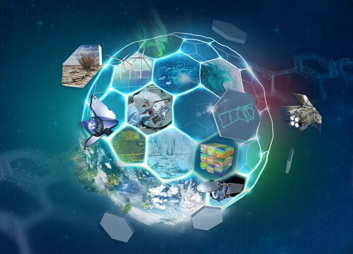
On 9 July 2025, leading scientists and experts in Earth observation will gather in Prague, Czechia, for a pivotal moment in Earth science – to delve into and debate the strengths of the two finalist candidate satellite missions, CAIRT and WIVERN, as they compete to be selected as ESA’s eleventh Earth Explorer.
 Image:
Earth from Space: Zanzibar, Tanzania
Image:
Earth from Space: Zanzibar, Tanzania
Antarctic waters getting saltier as sea ice wanes
4.7.2025 8:25
Using data from ESA’s SMOS satellite, scientists have revealed a surprising shift in the Southern Ocean – surface waters around Antarctica are growing saltier, even as sea ice is diminishing rapidly. This finding defies the norm because melting ice typically freshens ocean surface water.
The implications are far-reaching as changes in this remote region can disrupt global ocean currents, affect climate patterns, and alter ecosystems far beyond the Antarctic.
MTG-S1 and Copernicus Sentinel-4 mission highlights
2.7.2025 15:00 Video:
00:00:00
Video:
00:00:00
Two meteorological missions – Meteosat Third Generation Sounder-1 (MTG-S1) and the Copernicus Sentinel-4 mission – have launched on board a SpaceX Falcon 9 from Cape Canaveral in Florida, US.
Both are world-class Earth observation missions developed with European partners to address scientific and societal challenges.
The MTG-S1 satellite will generate a completely new type of data product, especially suited to nowcasting severe weather events, with three-dimensional views of the atmosphere. It is the second in the MTG constellation to be prepared for orbit and is equipped with the first European operational Infrared Sounder instrument.
Copernicus Sentinel-4 will be the first mission to monitor European air quality from geostationary orbit, providing hourly information that will transform how we predict air pollution across Europe, using its ultraviolet, visible, near-infrared light (UVN) spectrometer.
MTG-S1 and Copernicus Sentinel-4 mission highlights
2.7.2025 15:00
Video:
00:03:30
Two meteorological missions – Meteosat Third Generation Sounder-1 (MTG-S1) and the Copernicus Sentinel-4 mission – have launched on board a SpaceX Falcon 9 from Cape Canaveral in Florida, US.
Both are world-class Earth observation missions developed with European partners to address scientific and societal challenges.
The MTG-S1 satellite will generate a completely new type of data product, especially suited to nowcasting severe weather events, with three-dimensional views of the atmosphere. It is the second in the MTG constellation to be prepared for orbit and is equipped with the first European operational Infrared Sounder instrument.
Copernicus Sentinel-4 will be the first mission to monitor European air quality from geostationary orbit, providing hourly information that will transform how we predict air pollution across Europe, using its ultraviolet, visible, near-infrared light (UVN) spectrometer.
MTG-S1 and Sentinel-4 launch to change how we see our atmosphere
2.7.2025 0:30
The second of the Meteosat Third Generation (MTG) satellites and the first instrument for the Copernicus Sentinel-4 mission lifted off at 23:04 CEST on Tuesday, 1 July. The satellite is now on its way to monitor Earth’s atmosphere from an altitude of 36 000 km. From this geostationary orbit, the missions can provide game-changing data for forecasting severe storms and air pollution over Europe.
MTG-S1 and Copernicus Sentinel-4 launch from Florida
1.7.2025 23:04 Video:
00:00:57
Video:
00:00:57
Two meteorological missions – Meteosat Third Generation Sounder-1 (MTG-S1) and the Copernicus Sentinel-4 mission – have launched on board a SpaceX Falcon 9 from Cape Canaveral in Florida, US.
Both are world-class Earth observation missions developed with European partners to address scientific and societal challenges.
The MTG-S1 satellite will generate a completely new type of data product, especially suited to nowcasting severe weather events, with three-dimensional views of the atmosphere. It is the second in the MTG constellation to be prepared for orbit and is equipped with the first European operational Infrared Sounder instrument.
Copernicus Sentinel-4 will be the first mission to monitor European air quality from geostationary orbit, providing hourly information that will transform how we predict air pollution across Europe, using its ultraviolet, visible, near-infrared light (UVN) spectrometer.
Southern Europe’s land and sea sizzles
1.7.2025 13:41 Image:
A powerful heatwave has been gripping large parts of southern Europe. This image, captured by the Copernicus Sentinel-3 mission’s Sea and Land Surface Temperature Radiometer on 29 June 2025, reveals the temperature of the land surface.
Image:
A powerful heatwave has been gripping large parts of southern Europe. This image, captured by the Copernicus Sentinel-3 mission’s Sea and Land Surface Temperature Radiometer on 29 June 2025, reveals the temperature of the land surface.
MTG-S1 satellite hosting the Sentinel-4 instrument is ready for liftoff
30.6.2025 15:50
The Meteosat Third Generation Sounder (MTG-S1) satellite, which is hosting the instrument for the Copernicus Sentinel-4 mission, has been placed inside the nose cone of the Falcon 9 launch rocket and is ready for the scheduled liftoff at 23:03 CEST on Tuesday, 1 July.
Revisit Living Planet Symposium: watch session replays
29.6.2025 10:15Revisit Living Planet Symposium 2025
Watch session replays
Living Planet Symposium highlights in pictures
27.6.2025 18:20
ESA Living Planet Symposium concludes today, having brought together more than 6500 people across the Earth observation community. The takeaways include new connections, collaborations, not to mention the revelation of pioneering mission images. As a picture is worth a thousand words, here’s a selection that captures just a few of the many highlights.
Living Planet Symposium Extra News: Day 5
27.6.2025 13:45
ESA’s Living Planet Symposium came to a close today, concluding a week of networking, discussions and meeting of curious, scientific minds.
Today, one of the focal points was thermal imaging instruments, which are critical for monitoring land-surface temperature – and will be carried on upcoming missions such as the upcoming Copernicus Land Surface Temperature Mission. ESA’s Soil Moisture and Ocean Salinity (SMOS) mission celebrated passing its 15-year milestone in orbit – the mission has helped improve weather and climate models. Three new contracts were signed for ESA’s InCubed programme, which is central to the agency’s efforts to turn promising concepts into successful Earth observation services, strengthening Europe’s position in this rapidly evolving sector.
Swarm in tune with atmospheric hot flushes
27.6.2025 9:44
Scientists are harnessing data from ESA’s Swarm mission and ground-based instruments to precisely measure the strength and duration of intense upper-atmosphere heating – dramatic ‘hot flushes’ triggered by solar storms that also cause Earth’s tenuous outer atmospheric layers to expand rapidly.
This research, funded by ESA's Earth Observation FutureEO Science for Society initiative, offers crucial insights into how geomagnetic activity affects satellite orbits and space weather conditions.
Living Planet Symposium Extra News: Day 4
26.6.2025 17:15
The fourth day of ESA’s Living Planet Symposium was busier than ever.
Today, ESA signed an agreement on integrating satellite data into global environmental reporting frameworks as part of ESA’s Fundamental Data Records Framework. A contract with the Finnish government and the Finnish Meteorological Institute was signed to establish a calibration and validation ‘supersite’. ESA and the Taskforce on Nature-related Financial Disclosures paved the way to integrating satellite data into environmental reporting frameworks. And the New Space Scout missions were also in the spotlight as ESA signed a contract with ISISPACE to development of the Tango mission. Four new Scout mission concepts were also announced.
New ESA gravity mission to detect weakening ocean conveyor
26.6.2025 15:15
At the Living Planet Symposium, attendees have been hearing how ESA’s Next Generation Gravity Mission could provide the first opportunity to directly track a vital ocean circulation system that warms our planet – but is now weakening, risking a possible collapse with far-reaching consequences.
Watch MTG-S1 and Sentinel-4 launch live
26.6.2025 12:31
The second of the Meteosat Third Generation (MTG) satellites and the first instrument for the Copernicus Sentinel-4 mission are ready for liftoff at Cape Canaveral in Florida, US. Live coverage of this launch will be shown on ESA WebTV, on Tuesday, 1 July.
Watch MTG-S1 and Sentinel-4 launch live
26.6.2025 12:31
The second of the Meteosat Third Generation (MTG) satellites and the first instrument for the Copernicus Sentinel-4 mission are ready for liftoff at Cape Canaveral in Florida, US. Live coverage of this launch will be shown on ESA WebTV, not earlier than Tuesday, 1 July.
Satellite records expose fire driving Gran Chaco transformation
26.6.2025 10:30
At ESA’s Living Planet Symposium, scientist have unveiled how the combination of different long-term, high-resolution satellite datasets from ESA’s Climate Change Initiative is shedding new light on the South American Gran Chaco – one of the world’s most endangered dry forest ecosystems. These data reveal, in remarkable clarity, that fire is the primary driver of widespread, accelerating deforestation across the region.
Satellite records expose fire driving Gran Chaco transformation
26.6.2025 10:30
At ESA’s Living Planet Symposium, scientists have unveiled how the combination of different long-term, high-resolution satellite datasets from ESA’s Climate Change Initiative is shedding new light on the South American Gran Chaco – one of the world’s most endangered dry forest ecosystems. These data reveal, in remarkable clarity, that fire is the primary driver of widespread, accelerating deforestation across the region.
Living Planet Symposium Extras News: Day 3
25.6.2025 19:30
ESA’s week-long Living Planet Symposium in Austria is over halfway through, gathering thousands of attendees to explore the latest breakthroughs in Earth science and space technologies. In addition to in-depth coverage on specific themes from the symposium, we also bring you the following 'extras’: six New Space companies formally join Copernicus, ESA and UN-Habitat strengthen ties, and ESA and JAXA sign a Framework Agreement on climate collaboration.
Satellite data streamlines global development finance
25.6.2025 17:00
ESA is leading efforts to embed Earth observation data into more effective and resilient development financing. It is doing so in partnership with international financial institutions through its Global Development Assistance (GDA) programme. This topic was discussed today at ESA’s Living Planet Symposium.
High-resolution mapping reveals ocean carbon sink detail
25.6.2025 14:15
As atmospheric carbon dioxide levels continue to rise, the ocean plays a crucial role in helping to reduce the full impact of human-driven climate change by absorbing roughly a quarter of the carbon dioxide emitted by human activity. However, this uptake is far from uniform across the global ocean. A new satellite-based product can now map the ocean carbon sink at unprecedented resolution, offering unique insights into this highly variable and complex component of Earth’s climate system.
First sea-level records for coastal community protection
25.6.2025 11:00
While satellites have revolutionised our ability to measure sea level with remarkable precision, their data becomes less reliable near coasts – where accurate information is most urgently needed. To address this critical gap, ESA’s Climate Change Initiative Sea Level Project research team has reprocessed almost two decades of satellite data to establish a pioneering network of ‘virtual’ coastal stations. These stations now provide, for the first time, reliable and consistent sea-level measurements along coastlines.
Living Planet Symposium Extra News: Day 2
24.6.2025 18:35
ESA’s week-long Living Planet Symposium is in full swing in Vienna, Austria, drawing scientists and researchers from around the world. This flagship event focuses on the latest breakthroughs in Earth science and highlights the advanced space technologies used to observe and understand our changing planet. Throughout the week, we’ll be covering the bigger stories in depth, but we’re also sharing some daily snapshots of other significant happenings.
The major highlight of today was the signing of a landmark agreement between ESA and the Ramsar Convention on Wetlands.
North Atlantic’s volcanic secrets – it’s all about being thin
24.6.2025 15:00
Iceland is one of the most active volcanic regions in the world, but its seismic nature is part of a much broader geological history.
In a groundbreaking discovery, scientists, supported by an ESA-funded project, have uncovered the underlying forces that forged the North Atlantic’s fiery volcanic past – shedding light on the vast geological region that spans from Greenland to western Europe, which is home to iconic natural wonders like the Giant’s Causeway in Northern Ireland.
North Atlantic’s volcanic secrets – it’s about being thin
24.6.2025 15:00
Iceland is one of the most active volcanic regions in the world, but its seismic nature is part of a much broader geological history.
In a groundbreaking discovery, scientists, supported by an ESA-funded project, have uncovered the underlying forces that forged the North Atlantic’s fiery volcanic past – shedding light on the vast geological region that spans from Greenland to western Europe, which is home to iconic natural wonders like the Giant’s Causeway in Northern Ireland.
Sea ice lows high on the agenda
24.6.2025 12:00
Satellite observations reveal that the extent of sea ice in the Arctic is once again hovering near record lows for this time of year – underscoring a troubling and persistent trend. This issue is a key topic at ESA’s Living Planet Symposium in Vienna, where scientists are emphasising the critical role that ESA’s Climate Change Initiative Sea Ice Project and CryoSat mission have had in helping to underpin these findings.
Looking ahead, the ability to monitor polar sea ice is in safe hands, as the development of the new CRISTAL mission is progressing well and the first satellite will be ready for launch in the second half of 2027.
Italy's IRIDE programme marks major step with first satellite constellation
24.6.2025 8:30
Seven satellites have been launched for the Italian Earth observation mission, IRIDE. The satellites form part of the Hawk for Earth Observation (HEO) constellation, which carries multispectral optical instruments.
Living Planet Symposium Extras: Day 1
23.6.2025 18:00
ESA’s week-long Living Planet Symposium kicked off today in Vienna, Austria, bringing together scientists and researchers from around the globe. Throughout the week, we’ll be covering the bigger stories in depth, such as the first images from ESA’s Biomass mission published earlier today – but we’re also sharing some daily snapshots of other significant happenings.
So, today’s few ‘extras’ include Sentinel-2 marking 10 years in orbit, ESA selects Telespazio to run the ground segment for the TRUTHS mission and listen to EarthCARE data transformed into a dragon’s song for peace.
Living Planet Symposium Extra News: Day 1
23.6.2025 18:00
ESA’s week-long Living Planet Symposium kicked off today in Vienna, Austria, bringing together scientists and researchers from around the globe. Throughout the week, we’ll be covering the bigger stories in depth, such as the first images from ESA’s Biomass mission published earlier today – but we’re also sharing some daily snapshots of other significant happenings.
So, today’s few ‘extras’ include Sentinel-2 marking 10 years in orbit, ESA selects Telespazio to run the ground segment for the TRUTHS mission and listen to EarthCARE data transformed into a dragon’s song for peace.
Living Planet Symposium opens in Vienna
23.6.2025 17:10
ESA’s Living Planet Symposium, one of the world’s leading Earth observation conferences, opened today in Vienna.
Propellant loading completed for MTG-S1 and Sentinel-4
23.6.2025 13:40 Image:
Propellant loading completed for MTG-S1 and Sentinel-4
Image:
Propellant loading completed for MTG-S1 and Sentinel-4
Biomass satellite returns striking first images of forests and more
23.6.2025 12:20
Today, at the Living Planet Symposium, ESA revealed the first stunning images from its groundbreaking Biomass satellite mission – marking a major leap forward in our ability to understand how Earth’s forests are changing and exactly how they contribute to the global carbon cycle. But these inaugural glimpses go beyond forests. Remarkably, the satellite is already showing potential to unlock new insights into some of Earth’s most extreme environments.
Earth from Space: Vienna’s Danube divide
20.6.2025 10:00 Image:
A close-up view of Vienna, Austria’s capital city, is featured in this image from April 2025.
Image:
A close-up view of Vienna, Austria’s capital city, is featured in this image from April 2025.
First MetOp-SG and Sentinel-5 arrive at launch site
19.6.2025 9:18
Europe will soon be taking another leap forward in its weather forecasting capacity as the first MetOp Second Generation, MetOp-SG-A1, satellite arrives safely at Europe’s Spaceport in French Guiana, marking a pivotal moment on the road to launch.
This new polar-orbiting weather satellite also carries the Copernicus Sentinel-5 instrument to deliver daily global data on air pollutants and other atmospheric trace gases.
Watch live: Living Planet Symposium 2025
17.6.2025 14:49
One of the biggest Earth observation conferences in the world will take place next week in Vienna. You can watch streamed plenary discussions and presentations each day on ESA Web TV.
Watch live: Living Planet Symposium 2025
17.6.2025 14:49
One of the biggest Earth observation conferences in the world will take place next week in Vienna. You can watch streamed plenary discussions and presentations each day on ESA Web TV.
Media invitation: Register for MTG-S1 and Copernicus Sentinel-4 pre-launch briefings
13.6.2025 15:07
Media invitation: MTG-S1 and Sentinel-4 pre-launch briefings
Earth from Space: East Kalimantan, Borneo
13.6.2025 10:00 Image:
Copernicus Sentinel-1 captured this image over part of eastern Borneo, a tropical island in Southeast Asia.
Image:
Copernicus Sentinel-1 captured this image over part of eastern Borneo, a tropical island in Southeast Asia.
Earth from Space: Saharan dust plume
5.6.2025 16:00 Image:
A thick plume of sand and dust from the Sahara Desert is seen in these satellite images blowing from the west coast of Africa across the Atlantic Ocean.
Image:
A thick plume of sand and dust from the Sahara Desert is seen in these satellite images blowing from the west coast of Africa across the Atlantic Ocean.
Why MTG-S1 is a nowcasting game-changer
5.6.2025 12:23
The Meteosat Third Generation Sounder satellite (MTG-S) will generate a completely new type of data product, especially suited to nowcasting severe weather events. Here are five ways in which Europe’s latest weather satellite will change how we forecast weather.
Tall ship brings ESA ocean science training to Nice
4.6.2025 16:50
After an extraordinary six-week voyage from northern Norway, the iconic Norwegian tall ship Statsraad Lehmkuhl has docked in Nice, France, concluding ESA’s 2025 Advanced Ocean Training course. Braving everything from wild storms to calm near-freezing seas, students aboard mastered techniques for collecting ocean measurements and harnessed satellite data to unlock insights into our blue planet.
Led by experts, this real-world expedition offered more than education – it sparked curiosity and a deeper commitment to understanding and protecting our oceans.
A breath of fresh data: Sentinel-4’s innovations for clean air
4.6.2025 11:43
From its vantage point outside Earth’s atmosphere, more than 36 000 km above Earth’s surface, the Copernicus Sentinel-4 mission will detect major air pollutants over Europe in unprecedented detail. It will observe how they vary on an hourly basis – a real breakthrough for air quality forecasting.
A breath of fresh data: Sentinel-4 innovates for clean air
4.6.2025 11:43
From its vantage point outside Earth’s atmosphere, more than 36 000 km above Earth’s surface, the Copernicus Sentinel-4 mission will detect major air pollutants over Europe in unprecedented detail. It will observe how they vary on an hourly basis – a real breakthrough for air quality forecasting.
Mount Etna erupts
3.6.2025 16:22 Image:
The Copernicus Sentinel-2 mission has captured a dramatic image of Mount Etna erupting on 2 June 2025 when a massive plume of ash, gas and rock suddenly burst from Europe's largest active volcano.
Image:
The Copernicus Sentinel-2 mission has captured a dramatic image of Mount Etna erupting on 2 June 2025 when a massive plume of ash, gas and rock suddenly burst from Europe's largest active volcano.
Earth from Space: Cloud-free Iceland
30.5.2025 10:00 Image:
The Copernicus Sentinel-3 mission shows us a rare, cloud-free view of Iceland captured on 17 May 2025.
Image:
The Copernicus Sentinel-3 mission shows us a rare, cloud-free view of Iceland captured on 17 May 2025.
5 things we learned in EarthCARE’s impressive first year
29.5.2025 11:15
5 things we learned in EarthCARE’s impressive first year
5 things we learned in EarthCARE’s impressive first year
29.5.2025 11:15
Five things we learned in EarthCARE’s impressive first year
MTG-S and Sentinel-4 undergo pre-launch manoeuvres
28.5.2025 15:45 Image:
Following the arrival at Cape Canaveral in Florida, US, the Meteosat Third Generation Sounder satellite and the Copernicus Sentinel-4 instrument on board are currently being tested and prepared for launch, scheduled in July 2025.
Image:
Following the arrival at Cape Canaveral in Florida, US, the Meteosat Third Generation Sounder satellite and the Copernicus Sentinel-4 instrument on board are currently being tested and prepared for launch, scheduled in July 2025.
MTG-S and Sentinel-4 undergo pre-launch manoeuvres
28.5.2025 15:45
Image:
MTG-S and Sentinel-4 undergo pre-launch manoeuvres
ESA and UN harness space data for sustainable development
27.5.2025 11:27
ESA and UN harness space data for sustainable development
Media invitation: register for Living Planet Symposium 2025
26.5.2025 15:30
Media invitation: register for Living Planet Symposium 2025
Media invitation: register for Living Planet Symposium 2025
26.5.2025 15:30
Media invitation: register for Living Planet Symposium 2025
Earth from Space: Alakol, the multicoloured lake
23.5.2025 10:00 Image:
Lake Alakol in eastern Kazakhstan is featured in this radar image captured by Copernicus Sentinel-1.
Image:
Lake Alakol in eastern Kazakhstan is featured in this radar image captured by Copernicus Sentinel-1.
Media invitation: embark a tall ship for a dive into ocean science
22.5.2025 15:00
On the morning of 4 June 2025, ESA offers media representatives the exclusive opportunity to step aboard the iconic Norwegian tall ship Statsraad Lehmkuhl, docked at Quai Amiral Infernet in Nice, France. This remarkable vessel arrives following ESA’s six-week Advanced Ocean Training Course, a transformative journey from Tromsø, Norway, where emerging researchers have been immersed in the world of ocean science.
Earth from Space: Svalbard Archipelago
16.5.2025 10:00 Image:
The Copernicus Sentinel-2 mission brings us this cloud-free view of Svalbard, a remote Norwegian archipelago in the Arctic Ocean.
Image:
The Copernicus Sentinel-2 mission brings us this cloud-free view of Svalbard, a remote Norwegian archipelago in the Arctic Ocean.
Biomass completes a relay race of a LEOP
9.5.2025 11:00
Mission control at ESA’s European Space Operations Centre has completed the critical Launch and Early Orbit Phase (LEOP) for ESA’s Biomass, after nine days of intense work.
Earth from Space: Northwest Sardinia, Italy
9.5.2025 10:00 Image:
Part of the Italian island of Sardinia is featured in this image captured by the Copernicus Sentinel-2 mission.
Image:
Part of the Italian island of Sardinia is featured in this image captured by the Copernicus Sentinel-2 mission.
Antarctic glacier caught stealing ice from neighbour
8.5.2025 7:00
Thanks largely to Copernicus Sentinel-1, scientists have discovered that a glacier in Antarctica is rapidly siphoning ice from neighbouring flows – at a pace never before seen. Until now, researchers believed that this process of ‘ice piracy’ in Antarctica took hundreds or even thousands of years, but these latest findings clearly demonstrate that this isn’t always the case.
Antarctic glacier caught stealing ice from neighbour
8.5.2025 7:00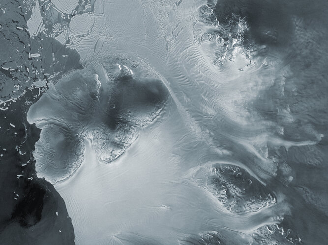
Thanks largely to Copernicus Sentinel-1, scientists have discovered that a glacier in Antarctica is rapidly siphoning ice from neighbouring flows – at a pace never before seen. Until now, researchers believed that this process of ‘ice piracy’ in Antarctica took hundreds or even thousands of years, but these latest findings clearly demonstrate that this isn’t always the case.
MTG-S1 and Sentinel-4 take a step closer to space
7.5.2025 15:50
Fresh from the cleanroom in Bremen, Germany, the second of the Meteosat Third Generation satellites and the first instrument for the Copernicus Sentinel-4 mission have arrived at Cape Canaveral harbour, in the US.
Forest satellite’s big antenna opens up
7.5.2025 10:15
Just a week after its launch, ESA’s Biomass mission has reached another critical milestone on its path to delivering unprecedented insights into the world’s forests and their vital role in Earth’s carbon cycle – the satellite’s 12-metre-diameter antenna is now fully deployed.
ESA unveils longest-ever dataset on forest biomass
2.5.2025 15:20
As the new Biomass satellite settles into life in orbit following its launch on 29 April, ESA has released its most extensive satellite-based maps of above-ground forest carbon to date. Spanning nearly two decades, the dataset offers the clearest global picture yet of how forest carbon stocks have changed over time.
Developed through ESA’s Climate Change Initiative, this new long-term record integrates data from multiple satellite missions – and will soon be further enhanced by data from the Biomass mission itself.
Earth from Space: World’s biggest iceberg
2.5.2025 10:00 Image:
The Ocean and Land Colour Instrument on Copernicus Sentinel-3 captured this image of Earth’s biggest iceberg, A23a, on 5 April 2025.
Image:
The Ocean and Land Colour Instrument on Copernicus Sentinel-3 captured this image of Earth’s biggest iceberg, A23a, on 5 April 2025.
Biomass launch highlights
29.4.2025 18:30 Video:
00:02:59
Video:
00:02:59
ESA’s state-of-the-art Biomass satellite launched aboard a Vega-C rocket from Europe’s Spaceport in Kourou, French Guiana. The rocket lifted off on 29 April 2025 at 11:15 CEST (06:15 local time).
In orbit, this latest Earth Explorer mission will provide vital insights into the health and dynamics of the world’s forests, revealing how they are changing over time and, critically, enhancing our understanding of their role in the global carbon cycle. It is the first satellite to carry a fully polarimetric P-band synthetic aperture radar for interferometric imaging. Thanks to the long wavelength of P-band, around 70 cm, the radar signal can slice through the whole forest layer to measure the ‘biomass’, meaning the woody trunks, branches and stems, which is where trees store most of their carbon.
Vega-C is the evolution of the Vega family of rockets and delivers increased performance, greater payload volume and improved competitiveness.
Launch of ESA’s Biomass mission from Kourou
29.4.2025 12:30 Video:
00:00:00
Video:
00:00:00
ESA’s state-of-the-art Biomass satellite launched aboard a Vega-C rocket from Europe’s Spaceport in Kourou, French Guiana. The rocket lifted off on 29 April 2025 at 11:15 CEST (06:15 local time).
In orbit, this latest Earth Explorer mission will provide vital insights into the health and dynamics of the world’s forests, revealing how they are changing over time and, critically, enhancing our understanding of their role in the global carbon cycle. It is the first satellite to carry a fully polarimetric P-band synthetic aperture radar for interferometric imaging. Thanks to the long wavelength of P-band, around 70 cm, the radar signal can slice through the whole forest layer to measure the ‘biomass’, meaning the woody trunks, branches and stems, which is where trees store most of their carbon.
Vega-C is the evolution of the Vega family of rockets and delivers increased performance, greater payload volume and improved competitiveness.
Launch of ESA’s Biomass mission from Kourou
29.4.2025 12:30
Video:
01:54:04
ESA’s state-of-the-art Biomass satellite launched aboard a Vega-C rocket from Europe’s Spaceport in Kourou, French Guiana. The rocket lifted off on 29 April 2025 at 11:15 CEST (06:15 local time).
In orbit, this latest Earth Explorer mission will provide vital insights into the health and dynamics of the world’s forests, revealing how they are changing over time and, critically, enhancing our understanding of their role in the global carbon cycle. It is the first satellite to carry a fully polarimetric P-band synthetic aperture radar for interferometric imaging. Thanks to the long wavelength of P-band, around 70 cm, the radar signal can slice through the whole forest layer to measure the ‘biomass’, meaning the woody trunks, branches and stems, which is where trees store most of their carbon.
Vega-C is the evolution of the Vega family of rockets and delivers increased performance, greater payload volume and improved competitiveness.
Replay: Biomass launch coverage
29.4.2025 12:30 Video:
01:54:04
Video:
01:54:04
ESA’s state-of-the-art Biomass satellite launched aboard a Vega-C rocket from Europe’s Spaceport in Kourou, French Guiana. The rocket lifted off on 29 April 2025 at 11:15 CEST (06:15 local time).
In orbit, this latest Earth Explorer mission will provide vital insights into the health and dynamics of the world’s forests, revealing how they are changing over time and, critically, enhancing our understanding of their role in the global carbon cycle. It is the first satellite to carry a fully polarimetric P-band synthetic aperture radar for interferometric imaging. Thanks to the long wavelength of P-band, around 70 cm, the radar signal can slice through the whole forest layer to measure the ‘biomass’, meaning the woody trunks, branches and stems, which is where trees store most of their carbon.
Vega-C is the evolution of the Vega family of rockets and delivers increased performance, greater payload volume and improved competitiveness.
Biomass launched to count forest carbon
29.4.2025 12:30
ESA’s groundbreaking Biomass satellite, designed to provide unprecedented insights into the world’s forests and their crucial role in Earth’s carbon cycle, has been launched. The satellite lifted off aboard a Vega-C rocket from Europe’s Spaceport in Kourou, French Guiana, on 29 April at 11:15 CEST (06:15 local time).
ESA’s Biomass mission launches on Vega-C
29.4.2025 11:30 Video:
00:02:01
Video:
00:02:01
ESA’s state-of-the-art Biomass satellite has launched aboard a Vega-C rocket from Europe’s Spaceport in French Guiana. The rocket lifted off on 29 April 2025 at 11:15 CEST (06:15 local time).
In orbit, this latest Earth Explorer mission will provide vital insights into the health and dynamics of the world’s forests, revealing how they are changing over time and, critically, enhancing our understanding of their role in the global carbon cycle. It is the first satellite to carry a fully polarimetric P-band synthetic aperture radar for interferometric imaging. Thanks to the long wavelength of P-band, around 70 cm, the radar signal can slice through the whole forest layer to measure the ‘biomass’, meaning the woody trunks, branches and stems, which is where trees store most of their carbon.
Vega-C is the evolution of the Vega family of rockets and delivers increased performance, greater payload volume and improved competitiveness.
ESA’s Biomass mission launches on Vega-C
29.4.2025 11:30
Video:
00:02:01
ESA’s state-of-the-art Biomass satellite has launched aboard a Vega-C rocket from Europe’s Spaceport in French Guiana. The rocket lifted off on 29 April 2025 at 11:15 CEST (06:15 local time).
In orbit, this latest Earth Explorer mission will provide vital insights into the health and dynamics of the world’s forests, revealing how they are changing over time and, critically, enhancing our understanding of their role in the global carbon cycle. It is the first satellite to carry a fully polarimetric P-band synthetic aperture radar for interferometric imaging. Thanks to the long wavelength of P-band, around 70 cm, the radar signal can slice through the whole forest layer to measure the ‘biomass’, meaning the woody trunks, branches and stems, which is where trees store most of their carbon.
Vega-C is the evolution of the Vega family of rockets and delivers increased performance, greater payload volume and improved competitiveness.
Biomass poised for liftoff to unveil forest secrets
28.4.2025 9:00
After years of careful design and preparation, ESA’s Earth Explorer Biomass satellite is set for launch tomorrow, 29 April at 11:15 CEST, aboard a Vega-C rocket from Europe’s Spaceport in French Guiana.
This groundbreaking mission will offer unprecedented insights into the state and evolution of the world’s forests. By mapping the woody material in Earth’s forests, this revolutionary satellite will play a crucial role in deepening our understanding of how forests influence the global carbon cycle.
Earth from Space: French Guiana
25.4.2025 10:00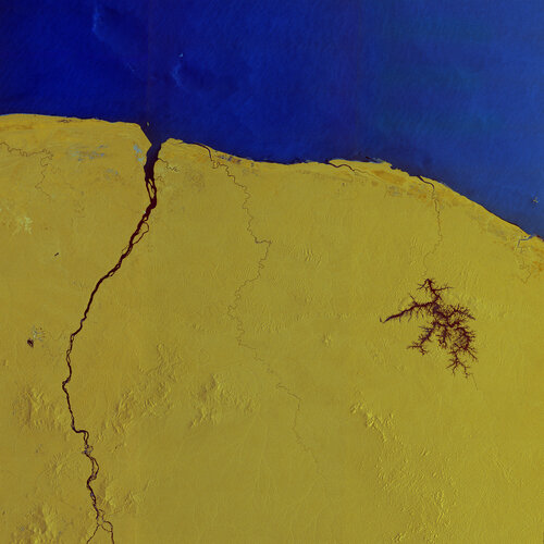 Image:
Copernicus Sentinel-1 captured this radar image over French Guiana – home to Europe’s Spaceport in Kourou, where ESA’s Biomass mission is being prepared for liftoff on 29 April onboard a Vega-C rocket.
Image:
Copernicus Sentinel-1 captured this radar image over French Guiana – home to Europe’s Spaceport in Kourou, where ESA’s Biomass mission is being prepared for liftoff on 29 April onboard a Vega-C rocket.
A new space age for forests – but groundwork still matters
24.4.2025 14:35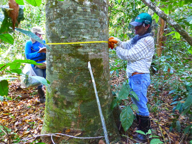
A new era of forest monitoring is quite literally taking off, ushering in what scientists are calling the ‘forest space age’. On April 29, ESA will launch its revolutionary Biomass mission, the first satellite to carry a P-band radar into space – technology that is set to transform how we understand forests and the carbon they store. Along with other space agencies’ instruments already in orbit or soon to be launched, there has never been so many ‘eyes in the sky’ focused on forests.
Yet, the work of people on the ground –often in the most remote and challenging forest regions – also remains essential.
Watch Biomass launch live
24.4.2025 11:50
ESA's Biomass mission is on the launch pad at Europe’s Spaceport in Kourou, French Guiana. Don’t miss the live coverage of liftoff on Tuesday 29 April, on ESA WebTV. Coverage will start at 10:55 CEST with commentary live from Kourou and ESA’s European Space Operations Centre in Germany. The Vega-C rocket carrying Biomass is scheduled for liftoff at 11:15.
Sentinel-1 captures ground shift from Myanmar earthquake
24.4.2025 8:36
On 28 March 2025, a powerful magnitude 7.7 earthquake struck central Myanmar, sending shockwaves through the region. While the country is still dealing with the devasting aftermath, scientists have used radar images from the Copernicus Sentinel-1 satellites to reveal a detailed picture of how the ground shifted as a result of the quake – offering new insights into the mechanics of the tectonic Sagaing Fault and the scale of the seismic rupture.