


![]()

ESA Observing the Earth 
zdroje zpráv:
Europe’s all-new weather satellite takes to the skies
13.12.2022 21:30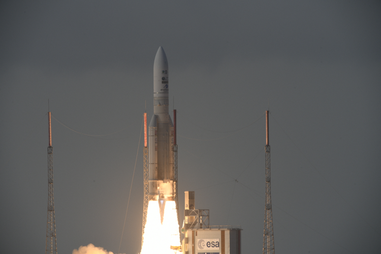 Image:
Europe’s all-new weather satellite takes to the skies
Image:
Europe’s all-new weather satellite takes to the skies
Watch now: Meteosat Third Generation Imager-1 launch
13.12.2022 19:40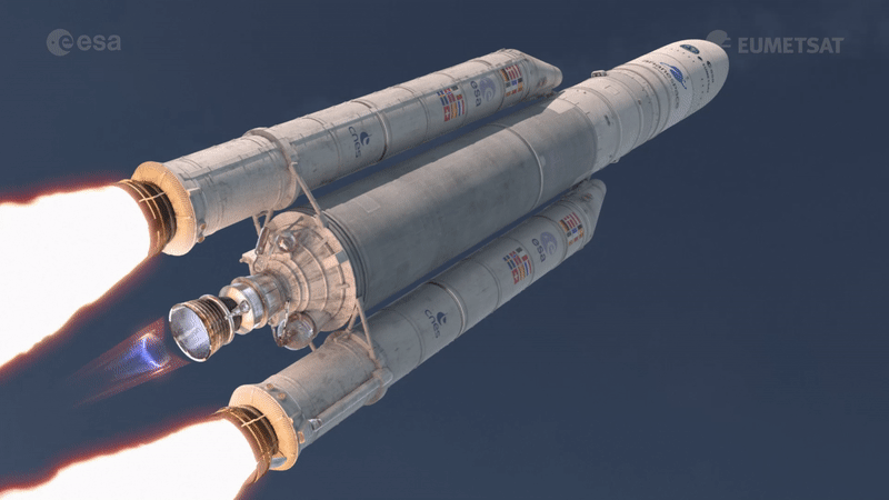
Watch now: Meteosat Third Generation Imager-1 launch
MTG-I1 rolled out and good to go
13.12.2022 10:40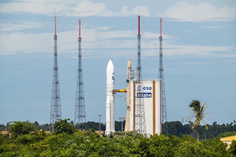
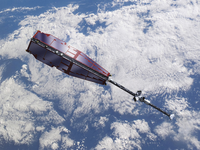
With liftoff set for today at 21:30 CET, the Ariane 5 rocket carrying the first Meteosat Third Generation Imager, MTG-I1, satellite is poised patiently on the launch pad at Europe’s Spaceport in French Guiana while the final checks are being carried out. Once in geostationary orbit, 36,000 km above the equator, this new satellite is set to herald a new era for meteorology.
Watch live launch of Meteosat Third Generation Imager-1
12.12.2022 8:50
On 13 December, the first of a new generation of satellites designed to revolutionise weather forecasting in Europe will take to the skies. ESA and the European Organisation for the Exploitation of Meteorological Satellites (Eumetsat) invite you to follow the live coverage for the launch of the first Meteosat Third Generation satellite starting from 19:40 CET on ESA Web TV.
MTG-I1 launch sequence in tune
9.12.2022 17:20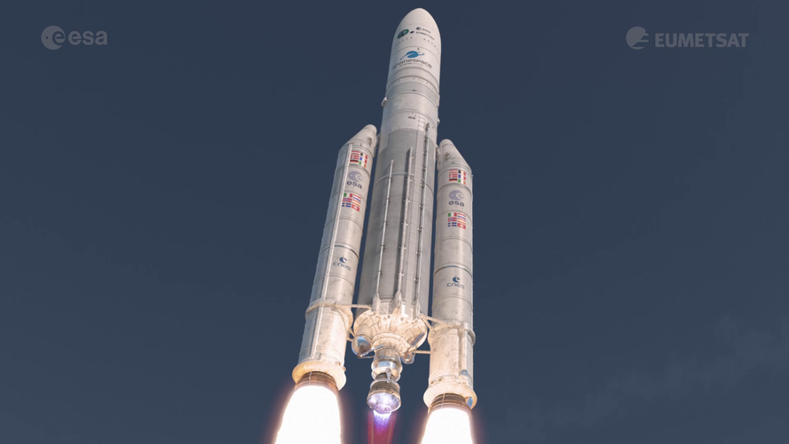 Video:
00:02:43
Video:
00:02:43
The animation shows the full launch sequence for the first Meteosat Third Generation Imager (MTG-I1) satellite. MTG-I1 launches on an Ariane 5 rocket from Europe’s Spaceport in Kourou, French Guiana.
MTG-I1 is the first of six satellites that form the full MTG system, which will provide critical data for weather forecasting over the next 20 years. In full operations, the mission will comprise two MTG-I satellites and one MTG Sounding (MTG-S) satellites working in tandem.
The MTG-I satellites carry two completely new instruments, a Flexible Combined Imager and Europe’s first Lightning Imager, to deliver high-quality data for better weather forecasting.
Earth from Space: Fucino, Italy
9.12.2022 10:00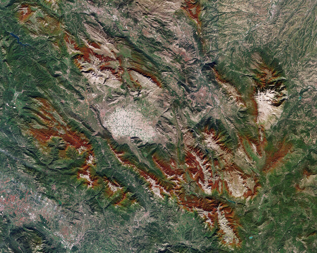
Tucked away in the Fucino Valley, in central Italy, lies the Fucino Space Centre, where Telespazio will manage the early orbit activities of the Meteosat Third Generation Imager, set to launch on 13 December from Europe’s Spaceport in French Guiana.
MTG-I1 never to be seen again
7.12.2022 16:17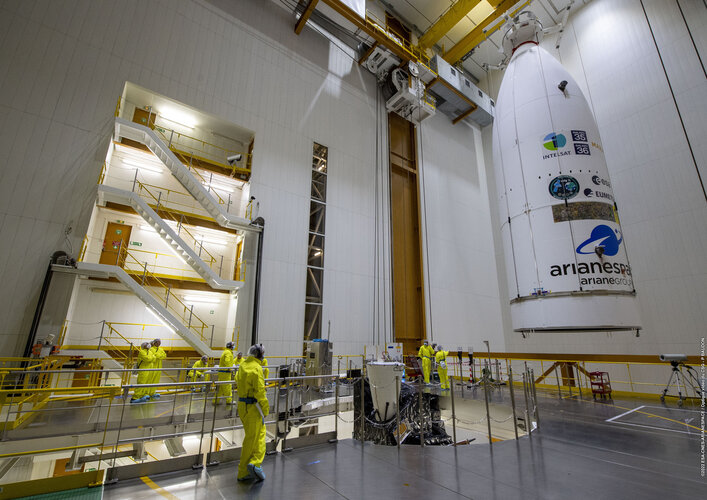
As preparations to launch Europe’s first Meteosat Third Generation Imager satellite continue, the team at Europe’s Spaceport in Kourou, French Guiana, has bid farewell to their precious satellite as it was sealed from view within the Ariane 5 rocket’s fairing. This all-new weather satellite is set to take to the skies on 13 December.
MTG-I1 never to be seen again
7.12.2022 16:17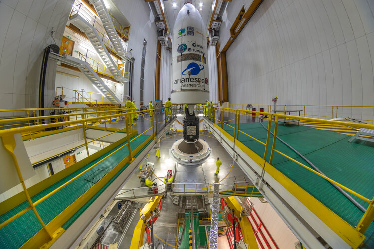
As preparations to launch Europe’s first Meteosat Third Generation Imager satellite continue, the team at Europe’s Spaceport in Kourou, French Guiana, has bid farewell to their precious satellite as it was sealed from view within the Ariane 5 rocket’s fairing. This all-new weather satellite is set to take to the skies on 13 December.
Launches secured for five Sentinel satellites
7.12.2022 14:47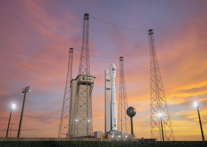
A contract signed today between ESA and Arianespace has ensured rides into orbit for five Copernicus Sentinels: Sentinel-1D, Sentinel-2C, Sentinel-3C, and the Copernicus Anthropogenic Carbon Dioxide-A and -B satellites. All the satellites will be launched on Vega-C rockets from Europe’s Spaceport in French Guiana and are scheduled to take place between 2024 and 2026.
Coming soon: MTG The Next Generation
6.12.2022 15:10 Video:
00:00:48
Video:
00:00:48
One week today, the first of a new generation of weather satellites will take to the skies. The Meteosat Third Generation system is the most complex and innovative meteorological satellite system ever built. It will bring new capabilities to monitor weather, climate and the environment from space like never before – promising to further bolster Europe’s leadership in weather forecasting.
Join us for the live launch coverage of the Metetosat Third Generation Imager on 13 December on ESA Web TV.
Animations provided by Mlabspace
Coming soon: MTG The Next Generation
6.12.2022 15:10
Video:
00:00:48
One week today, the first of a new generation of weather satellites will take to the skies. The Meteosat Third Generation system is the most complex and innovative meteorological satellite systems ever built. It will bring new capabilities to monitor weather, climate and the environment from space like never before – promising to further bolster Europe’s leadership in weather forecasting.
Join us for the live launch coverage of the Metetosat Third Generation Imager on 13 December on ESA Web TV.
Coming soon: MTG The Next Generation
6.12.2022 15:10
Video:
00:00:48
One week today, the first of a new generation of weather satellites will take to the skies. The Meteosat Third Generation system is the most complex and innovative meteorological satellite system ever built. It will bring new capabilities to monitor weather, climate and the environment from space like never before – promising to further bolster Europe’s leadership in weather forecasting.
Join us for the live launch coverage of the Metetosat Third Generation Imager on 13 December on ESA Web TV.
Replay: MTG-I1 pre-launch briefing
5.12.2022 15:51 Video:
00:43:38
Video:
00:43:38
Watch the replay of the Meteosat Third Generation Imager-1 pre-launch press briefing held on 5 December 2022. Speakers include Simonetta Cheli, ESA’s Director of Earth Observation Programmes; Phil Evans, Director General of Eumetsat; Bertrand Denis, Vice President Observation and Science at Thales Alenia Space and Simon Keogh, Head of Space Applications and Nowcasting Research & Development at the UK Met Office.
MTG-I1 is scheduled to be launched on 13 December on an Ariane 5 rocket from Europe’s Spaceport in French Guiana. It is the first of six satellites that form the full MTG system, which will provide critical data for weather forecasting over the next 20 years. In full operations, the mission will comprise two MTG-I satellites and one MTG Sounding (MTG-S) satellites working in tandem.
The MTG-I satellites carry two completely new instruments, a Flexible Combined Imager and Europe’s first Lightning Imager, to deliver high-quality data for better weather forecasting.
Replay: MTG-I1 pre-launch briefing
5.12.2022 15:51 Video:
00:00:00
Video:
00:00:00
Watch the replay of the Meteosat Third Generation Imager-1 pre-launch press briefing held on 5 December 2022. Speakers include Simonetta Cheli, ESA’s Director of Earth Observation Programmes; Phil Evans, Director General of Eumetsat; Bertrand Denis, Vice President Observation and Science at Thales Alenia Space and Simon Keogh, Head of Space Applications and Nowcasting Research & Development at the UK Met Office.
MTG-I1 is scheduled to be launched on 13 December on an Ariane 5 rocket from Europe’s Spaceport in French Guiana. It is the first of six satellites that form the full MTG system, which will provide critical data for weather forecasting over the next 20 years. In full operations, the mission will comprise two MTG-I satellites and one MTG Sounding (MTG-S) satellites working in tandem.
The MTG-I satellites carry two completely new instruments, a Flexible Combined Imager and Europe’s first Lightning Imager, to deliver high-quality data for better weather forecasting.
Replay: MTG-I1 pre-launch briefing
5.12.2022 15:51
Video:
00:43:38
Watch the replay of the Meteosat Third Generation Imager-1 pre-launch press briefing held on 5 December 2022. Speakers include Simonetta Cheli, ESA’s Director of Earth Observation Programmes; Phil Evans, Director General of Eumetsat; Bertrand Denis, Vice President Observation and Science at Thales Alenia Space and Simon Keogh, Head of Space Applications and Nowcasting Research & Development at the UK Met Office.
MTG-I1 is scheduled to be launched on 13 December on an Ariane 5 rocket from Europe’s Spaceport in French Guiana. It is the first of six satellites that form the full MTG system, which will provide critical data for weather forecasting over the next 20 years. In full operations, the mission will comprise two MTG-I satellites and one MTG Sounding (MTG-S) satellites working in tandem.
The MTG-I satellites carry two completely new instruments, a Flexible Combined Imager and Europe’s first Lightning Imager, to deliver high-quality data for better weather forecasting.
Watch now: MTG-I1 pre-launch press briefing
5.12.2022 15:15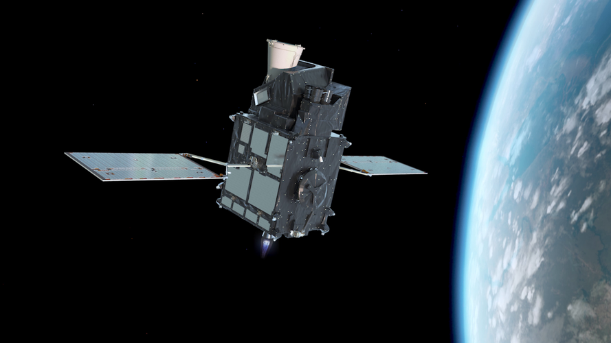
Watch now: MTG-I1 pre-launch press briefing

Green City Makers wins top prize at Copernicus Masters
2.12.2022 12:06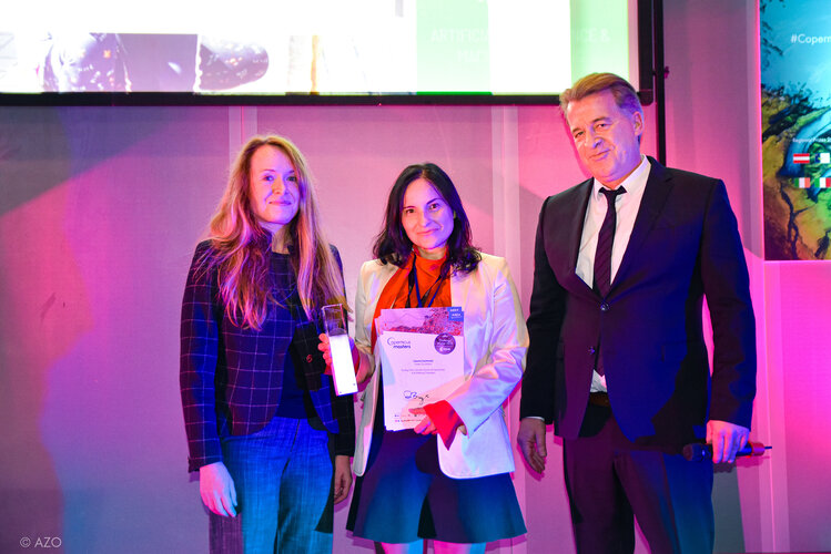
Green City Makers wins top prize at Copernicus Masters
Earth from Space: the moraines of Malaspina
2.12.2022 10:00
The remarkable moraine patterns of Malaspina Glacier – the largest piedmont glacier in the world – are featured in this false-colour image acquired by Copernicus Sentinel-2.
Media invitation: Meteosat Third Generation Imager-1 launch
29.11.2022 11:15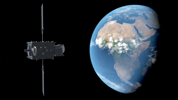
Media invitation: Meteosat Third Generation Imager-1 launch
Glacier calving and a whole lot of mixing
29.11.2022 8:00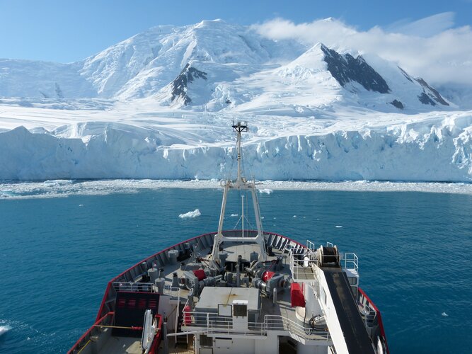
It’s no surprise that when a massive lump of ice drops off the edge of a glacier into the sea, the surface waters of the ocean get pretty churned up. However, in addition to causing tsunamis at the surface of the ocean, recent research has led to the discovery that glacier calving can excite vigorous internal tsunami waves – a process that has been neglected in driving ocean mixing in computer models.
New weather satellite fully loaded
28.11.2022 7:52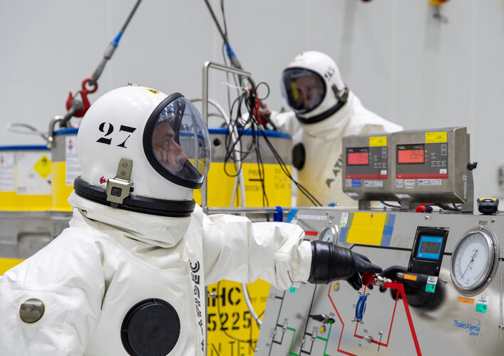
With liftoff now scheduled for 13 December, Europe’s first Meteosat Third Generation Imager (MTG-I1) satellite has been fuelled – a critical and extremely hazardous milestone on the road to launch. Once in geostationary orbit 36,000 km above the equator, this all-new weather satellite will provide state-of-the art observations of Earth’s atmosphere and realtime monitoring of lightning events, taking weather forecasting to the next level.
Locked and loaded
28.11.2022 7:52
With liftoff now scheduled for 13 December, Europe’s first Meteosat Third Generation Imager (MTG-I1) satellite has been fuelled – a critical and extremely hazardous milestone on the road to launch. Once in geostationary orbit 36,000 km above the equator, this all-new weather satellite will provide state-of-the art observations of Earth’s atmosphere and realtime monitoring of lightning events, taking weather forecasting to the next level.
Earth from Space: Zaragoza, Spain
25.11.2022 10:00
The province of Zaragoza, in northeast Spain, is featured in this image captured by the Copernicus Sentinel-2 mission.
Watch live: ESA Council Meeting at Ministerial Level
21.11.2022 11:01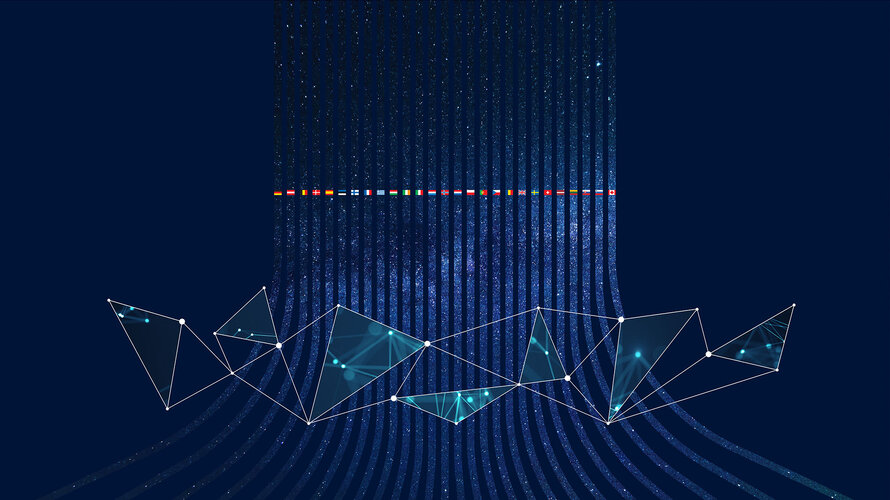
The ESA Council at Ministerial level (CM22) is taking place in Paris, France, on 22 and 23 November. ESA’s Member States, Associated States and Cooperating States will be invited to together strengthen Europe’s space ambitions and ensure that space continues to serve European citizens. Follow our live coverage of CM22 via ESA WebTV.
Watch live: ESA Council meeting at Ministerial level
21.11.2022 11:01
The ESA Council at Ministerial level (CM22) is taking place in Paris, France, on 22 and 23 November. ESA’s Member States, Associate Members and Cooperating States will be invited to together strengthen Europe’s space ambitions and ensure that space continues to serve European citizens. Follow our live coverage of CM22 via ESA WebTV.
Putting a value on ESA’s Aeolus wind mission
18.11.2022 13:20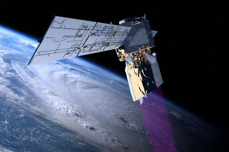
Over the last four years, ESA’s Aeolus mission has been delivering unique profiles of Earth’s winds from space, improving operational weather forecasts, climate models and more – all showing that its novel laser technology is advancing science and being used for important practical applications. Adding to the list of Aeolus’ successes, a recent report highlights that the mission has also brought economics benefits to Europe to the tune of €3.5 billion, and that a follow-on mission could more than double this figure.
Earth from Space: Sharm El-Sheikh, Egypt
18.11.2022 10:00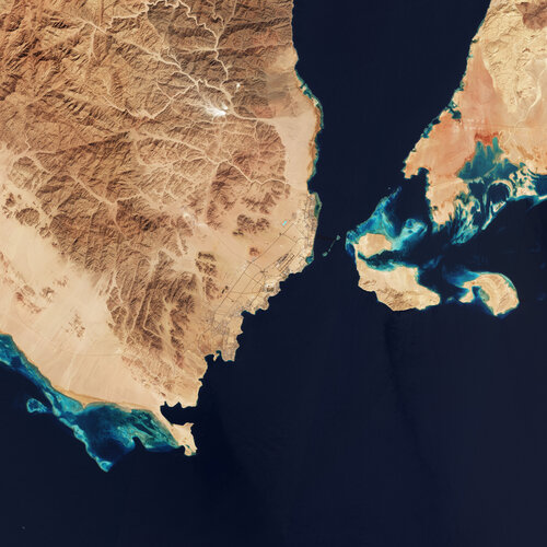
World leaders, policymakers and delegates from nearly 200 countries have convened in Sharm El-Sheikh over the past two weeks at the COP27 UN Climate Summit. Today we take a closer look at the Egyptian city through the eyes of Copernicus Sentinel-2.
Strengthening InCubed’s role in commercial Earth observation
17.11.2022 15:00
Commercialisation is universally recognised as essential for the future prosperity of all aspects of the European space sector, and Earth observation is no exception. The ESA InCubed programme, a co-funding initiative that helps entrepreneurs bring their innovative ideas to market, has enjoyed enormous success since the launch of its first activity in 2018 and continues to make a prodigious contribution to commercial Earth observation. The InCubed portfolio includes around 60 activities, with an impressive €63 million invested so far.
At the upcoming ESA Council at Ministerial Level, Member States will have the possibility to further empower InCubed in its far-reaching efforts to foster commercial innovation. The programme proposal makes the case for a wider remit, including a set of new ‘Invest Actions’ designed to help boost the European Earth observation economy and reinforce relationships with the private investor community.
Pushing the boundaries of space
16.11.2022 13:30 Video:
00:02:02
Video:
00:02:02
Space is delivering more accurate, more precise and more varied data than ever before. State-of-the-art digital technologies, such as Digital Twins of Earth and High Performance Computing, are enabling faster and more complex calculations, allowing us to replicate the Earth system, its climate and life on our planet.
ESA is exploiting digital technologies and artificial intelligence, supporting scientists and industry to respond to global challenges such as the climate crisis and designing innovative solutions for our future.
ESA’s Council at Ministerial level, CM22, taking place next week is a time for critical decisions. Space supports scientists, policymakers and political leaders not only to monitor, understand, model and predict, but – crucially – to act on climate-induced and other crises.
Earth observation data allows institutions, the scientific community, citizens and industry to harness space data for their use – paving the way for a sustainable and green future for all.
Pushing the boundaries of space
16.11.2022 13:30
Video:
00:02:02
Space is delivering more accurate, more precise and more varied data than ever before. State-of-the-art digital technologies, such as Digital Twins of Earth and High Performance Computing, are enabling faster and more complex calculations, allowing us to replicate the Earth system, its climate and life on our planet.
ESA is exploiting digital technologies and artificial intelligence, supporting scientists and industry to respond to global challenges such as the climate crisis and designing innovative solutions for our future.
ESA’s Council at Ministerial level, CM22, taking place next week is a time for critical decisions. Space supports scientists, policymakers and political leaders not only to monitor, understand, model and predict, but – crucially – to act on climate-induced and other crises.
Earth observation data allows institutions, the scientific community, citizens and industry to harness space data for their use – paving the way for a sustainable and green future for all.
Sentinel-5P data used in new methane detection system
16.11.2022 10:00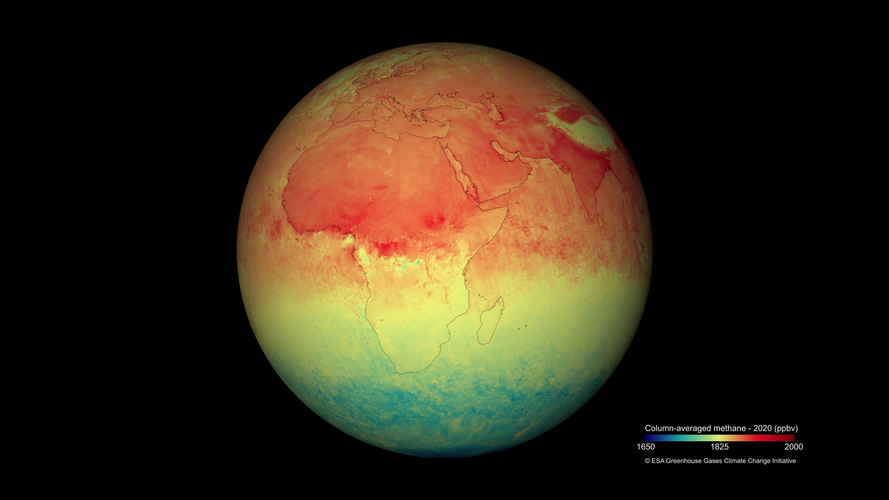
As part of worldwide efforts to slow climate change, the United Nations has revealed a new satellite-based system to detect methane emissions. The Methane Alert and Response System (MARS) initiative, launched at COP27, will scale up global efforts to detect and act on major emissions sources and accelerate the implementation of the Global Methane Pledge.
The Sentinel-5P satellite, the first Copernicus mission dedicated to monitoring our atmosphere, will be crucial in implementing this ambitious initiative.
ESA Extremes
15.11.2022 10:50 Image:
ESA is Europe’s space agency, enabling its 22 Member States to achieve results in space that no individual nation can match. Covering every aspect of space, from exploration to Earth observation to telecommunications and navigation, this potent formula has chalked up several extreme achievements for Europe. Here are a select few out of many:
Image:
ESA is Europe’s space agency, enabling its 22 Member States to achieve results in space that no individual nation can match. Covering every aspect of space, from exploration to Earth observation to telecommunications and navigation, this potent formula has chalked up several extreme achievements for Europe. Here are a select few out of many:
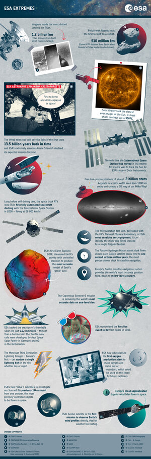 Image:
ESA Extremes
Image:
ESA Extremes
Strong European support for space to combat climate crisis
15.11.2022 9:20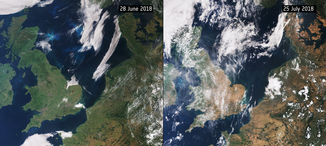
Europe should demonstrate responsibility, leadership and autonomy in space – and its highest priority should be to address climate change, according to a poll of European citizens.
Results from ESA’s Climate Change Initiative on display at COP27
14.11.2022 17:00
Achieving net-zero by the second half of the century is considered vital if global temperatures are to remain well below the two degrees rise as set out by the Paris Agreement for climate. From their vantage point in space, satellites provide a unique means of tracking progress towards achieving this balance between greenhouse gas emissions from sources and removal by sinks.
How space-based approaches can support the UN Global stocktake, starting in 2023, are the focus of technical discussions at the 2022 United Nations Climate Change Conference (COP27) currently taking place in Sharm El-Sheikh, and feature results from ESA’s trailblazing REgional Carbon Cycle Assessment and Processes project. These results come at a critical time ahead of next week’s ESA Council Meeting at Ministerial Level.
ESA results on display at COP27
14.11.2022 17:00
Achieving net-zero by the second half of the century is considered vital if global temperatures are to remain well below the two degrees rise as set out by the Paris Agreement for climate. From their vantage point in space, satellites provide a unique means of tracking progress towards achieving this balance between greenhouse gas emissions from sources and removal by sinks.
How space-based approaches can support the UN Global stocktake, starting in 2023, are the focus of technical discussions at the 2022 United Nations Climate Change Conference (COP27) currently taking place in Sharm El-Sheikh, and feature results from ESA’s trailblazing REgional Carbon Cycle Assessment and Processes project. These results come at a critical time ahead of next week’s ESA Council Meeting at Ministerial Level.
Biomass heads for the shaker
14.11.2022 16:53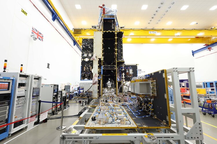
Over the last six months, engineers at Airbus in Stevenage, UK, and teams from Europe and North America have turned a multitude of structural parts and electronic units into a complete satellite: ESA’s Biomass satellite. Now complete, this brand-new satellite has been shipped to Airbus’ testing facility in Toulouse, France, where it will be put through its paces to ensure that it will survive the rigours of liftoff and the harsh environment of space to deliver on its promise, that being to yield new insight into Earth’s precious forests.
Earth from Space: Santiago, Chile
11.11.2022 10:00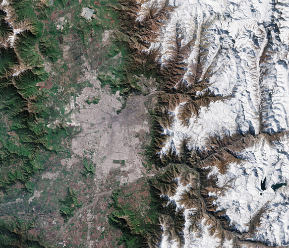
The Copernicus Sentinel-2 mission captured this image of Santiago – the capital and largest city of Chile.
Call for Media: launch of the first Meteosat Third Generation satellite MTG-I1
8.11.2022 9:37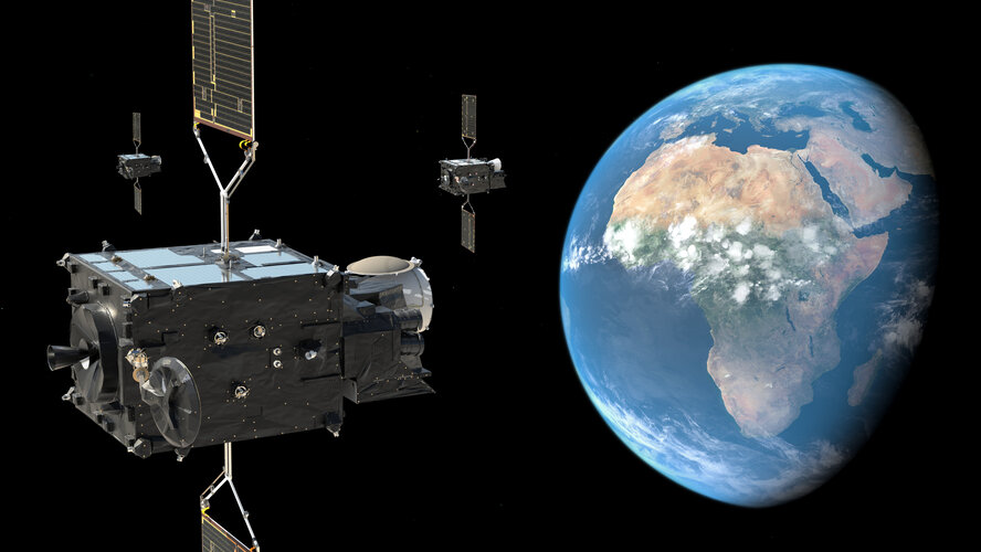
Call for Media: launch of the first MTG satellite MTG-I1
Earth from Space: Nushagak Bay, Alaska
4.11.2022 10:00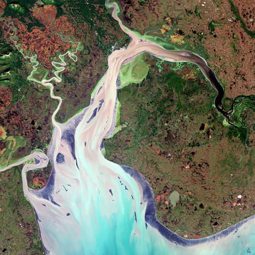
The complex and diverse landscape that surrounds Nushagak Bay in Alaska is featured in this true-colour image captured by the Copernicus Sentinel-2 mission.
Earth Observation Excellence Award deadline approaching
3.11.2022 10:45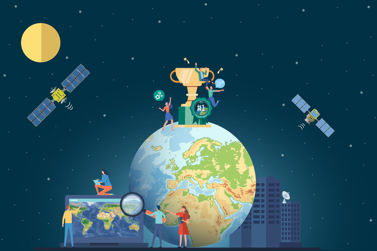
In a little over a month, the window of opportunity for nominating deserving scientists for the prestigious ESA-EGU Earth Observation Excellence Award will close. With the period for lodging nominations closing on 7 December, past nominators and winners reflect on how this award has increased the visibility of their scientific research and opened new avenues to working partnerships.
Give climate some MAGIC
31.10.2022 15:44
There are times when we could all do with a bit of magic in our lives. And, with the Global Climate Observing System announcement of ‘terrestrial water storage’ as a completely new Essential Climate Variable, the world of climate research and climate crisis response would certainly benefit from a satellite mission called MAGIC.
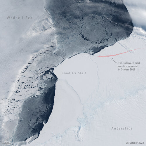 Image:
Halloween Crack for Halloween
Image:
Halloween Crack for Halloween
Earth from Space: Svalbard
28.10.2022 10:00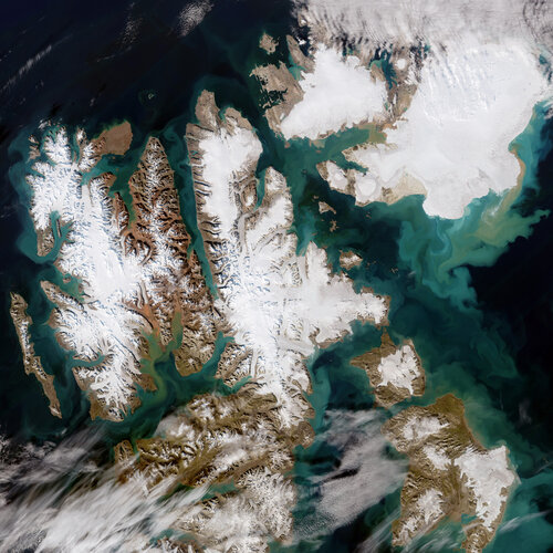
Extremely high temperatures recorded this summer caused record melting across Svalbard – one of the fastest warming places on the planet. The Copernicus Sentinel-2 mission captured this rare, cloud-free acquisition of the Norwegian archipelago in August 2022.
From Rome to Cannes
25.10.2022 8:45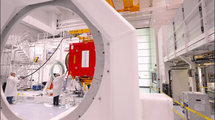
The Copernicus Sentinel-1C satellite is currently in Cannes undergoing a series of demanding tests in preparation for launch in 2023. The third member of the Sentinel-1 radar family, part of Europe’s Copernicus programme, will continue the critical task of delivering key radar imagery of Earth’s surface for a wide range of services and scientific applications.
Boosting Earth science
24.10.2022 13:47
With science at the core of the Earth Observation FutureEO programme, ESA has opened a new scientific facility, the Science Hub, which offers new opportunities for collaborative research to further boost the Agency’s and its Member States scientific output.
The scary sound of Earth’s magnetic field
24.10.2022 8:00
Despite being essential to life on Earth, the magnetic field isn’t something we can actually see in itself, or ever hear. But, remarkably, scientists at the Technical University of Denmark have taken magnetic signals measured by ESA’s Swarm satellite mission and converted them into sound – and for something that protects us, the result is pretty scary.
Earth from Space: Inhambane Bay, Mozambique
21.10.2022 10:00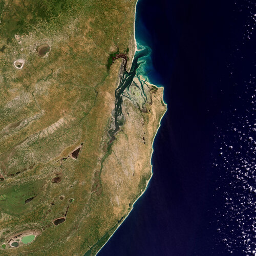
Inhambane Bay, in southeast Mozambique, is featured in this true-colour image captured by the Copernicus Sentinel-2 mission.
Europe’s all-new weather satellite arrives at launch site
18.10.2022 10:30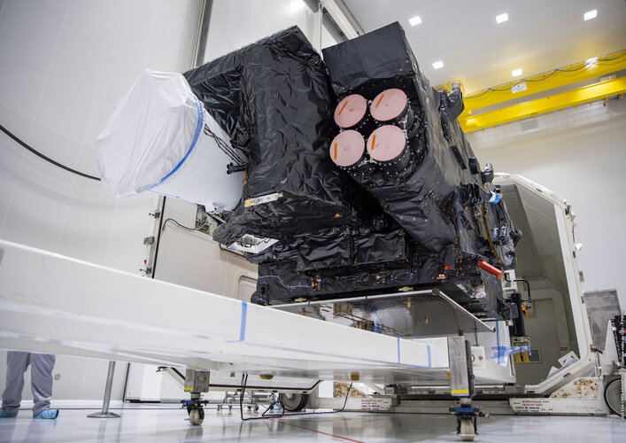
After a two-week voyage across the Atlantic Ocean, the ship transporting the first Meteosat Third Generation satellite docked at Pariacabo in French Guiana and the precious cargo unloaded. Now safe and sound in one of the spaceport’s cleanrooms, satellite engineers will ready it for liftoff on an Ariane 5 rocket in December. Once in geostationary orbit, this new satellite, which carries two new extremely sensitive instruments, promises to further bolster Europe's leadership in weather forecasting.
Earth from Space: Mississippi River
14.10.2022 10:00
Mississippi River, one of the longest rivers in North America, is featured in this multi-temporal radar image captured by the Copernicus Sentinel-1 mission.
Earth from Space: Mississippi River
14.10.2022 10:00
Mississippi River, one of the longest rivers in North America, is featured in this multi-temporal radar image captured by the Copernicus Sentinel-1 mission.
Seasonal changes in Antarctic ice sheet flow dynamics detected for the first time
12.10.2022 11:00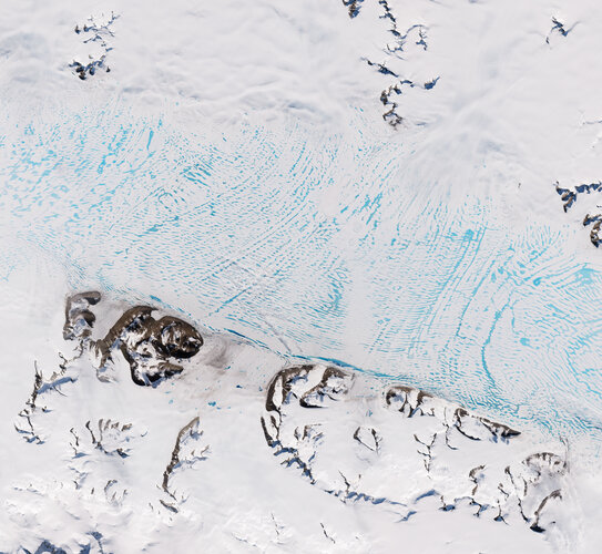
Certain estimates of Antarctica’s total contribution to sea-level rise may be over, or even underestimated, after researchers detected a previously unknown source of ice loss variability. In a new paper published in The Cryosphere, researchers using Copernicus Sentinel-1 data, found that glaciers feeding the George VI Ice Shelf speed up by approximately 15% during the Antarctic summer. This is the first time that such seasonal cycles have been detected on land ice flowing into ice shelves in Antarctica.
Italy’s Stromboli erupts
10.10.2022 16:00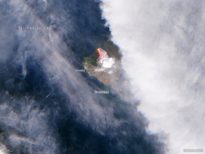 Image:
A volcano on the Italian island of Stromboli erupted early on Sunday morning, releasing huge plumes of smoke and a lava flow pouring into the sea. The Copernicus Sentinel-2 mission captured this image of the aftermath less than five hours after the eruption.
Image:
A volcano on the Italian island of Stromboli erupted early on Sunday morning, releasing huge plumes of smoke and a lava flow pouring into the sea. The Copernicus Sentinel-2 mission captured this image of the aftermath less than five hours after the eruption.
TRUTHS on the table at ESA’s Ministerial Council
10.10.2022 14:45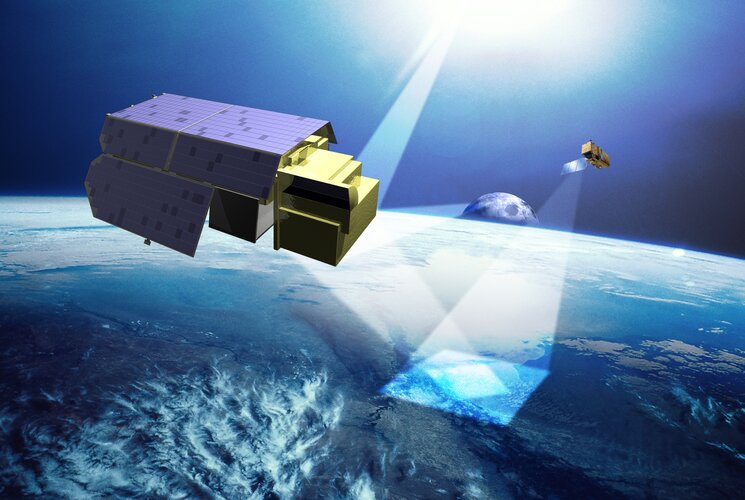
With the satellite and instrument design consolidated and the scientific community assured it will deliver the data they need, TRUTHS has been approved as part of Earth Observation Programme proposal for the upcoming ESA Council Meeting at Ministerial Level. Carrying a primary International System of Units reference system, TRUTHS promises to set the gold standard for climate measurements.
Earth observation inspires global inventiveness
10.10.2022 11:35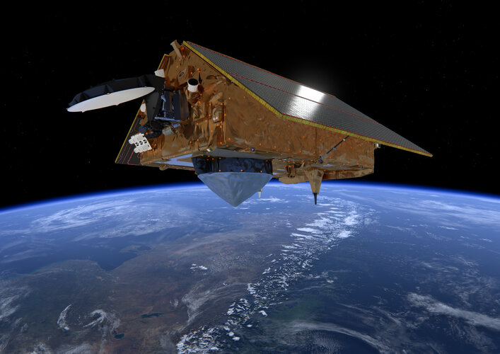
Today our home planet Earth is being more closely monitored than at any time in its history. Some 1 460 Earth-observing satellites have been launched during the last two decades, with Europe’s Copernicus Sentinel fleet in the forefront of environmental data gathering. A new report led by the European Patent Office examining associated patent filings reveals a 1 800% increase in the same period – with European activity comparatively stagnant compared to international competitors.
Earth from Space: Bouches-du-Rhône
7.10.2022 10:00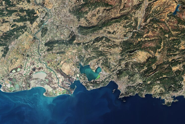
The port town of Fos-Sur-Mer, in the southern part of Bouches-du-Rhône, France, is featured in this image captured by Copernicus Sentinel-2. It is from here where the first Meteosat Third Generation Imager satellite set sail last week on its journey to Europe’s Spaceport in French Guiana.
Satellites detect methane plume in Nord Stream leak
6.10.2022 10:02
Following unusual seismic disturbances in the Baltic Sea, several leaks were discovered last week in the underwater Nord Stream 1 and 2 gas pipelines, near Denmark and Sweden. Neither pipeline was transporting gas at the time of the blasts, but they still contained pressurised methane – the main component of natural gas – which spewed out producing a wide stream of bubbles on the sea surface.
With the unexplained gas release posing a serious question about the incident’s environmental impact, a suite of complementary Earth observation satellites carrying optical and radar imaging instruments were called upon to characterise the gas leak bubbling in the Baltic.
Europe’s new weather satellite sets sail
30.9.2022 10:45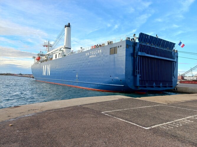
The first of Europe’s Meteosat Third Generation satellites is now safely aboard a ship and making its way across the Atlantic to French Guiana where it will be readied for liftoff in December. Once launched into geostationary orbit, 36 000 km above Earth, this new satellite, which carries two new extremely sensitive instruments, will take weather forecasting to the next level.
Europe’s new weather satellite sets sail
30.9.2022 10:45
The first of Europe’s Meteosat Third Generation satellites is now safely aboard a ship and making its way across the Atlantic to French Guiana where it will be readied for liftoff in December. Once launched into geostationary orbit, 36 000 km above Earth, this new satellite, which carries two new extremely sensitive instruments, will take Europe's leadership in weather forecasting to the next level.
Earth from Space: Melt ponds in West Greenland
30.9.2022 10:00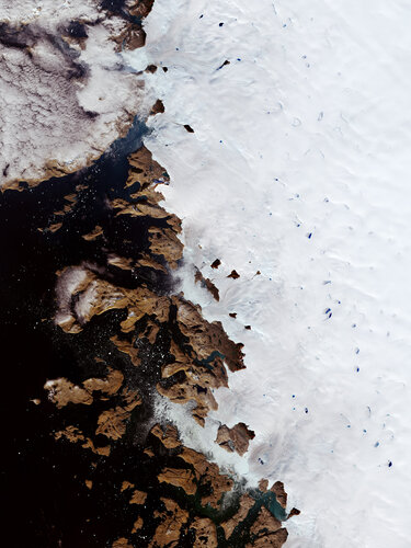
During spring and summer, as the air warms up and the sun beats down on the Greenland Ice Sheet, melt ponds pop up. Melt ponds are vast pools of open water that form on both sea ice and ice sheets and are visible as turquoise-blue pools of water in this Copernicus Sentinel-2 image.
New weather satellite on its way to launch
30.9.2022 9:00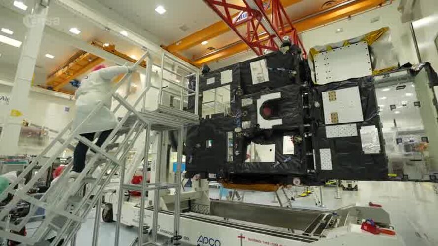 Video:
00:04:04
Video:
00:04:04
The final pre-launch preparations for the first Meteosat Third Generation (MTG) satellite are underway. The first satellite, called MTG-I1, built by a European industrial consortium led by Thales Alenia Space carries two imagers: an advanced Flexible Combined Imager and, in a first for Europe, a Lightning Imager that will allow the earlier detection of storms and extreme weather events, as well as improve aviation safety.
Building on the long-standing partnership between ESA and Eumetsat, the MTG-I1 will be one of six satellites operating in a fleet, of three at a time, to ensure the continuity of data from the previous Meteosat satellites over the next 20 years. The first Meteosat was launched in 1977 and this third generation of spacecraft will be the most advanced yet, with improved image resolution and providing close to real time data for users, or ‘nowcasting’ of fast-developing, high-impact weather.
The launch is currently scheduled for the end of 2022.
The film includes soundbites from ESA Director of Earth Observation Programmes: Simonetta Cheli, ESA Meteosat Programme Manager: Paul Blythe, ESA Meteosat Third Generation Payload Manager: Donny Aminou and EUMETSAT, Meteosat Third Generation Programme Manager: Alexander Schmid,
Please find more information at: https://www.esa.int/Applications/Observing_the_Earth/Meteorological_missions/meteosat_third_generation
New weather satellite on its way to launch
30.9.2022 9:00
Video:
00:04:04
The final pre-launch preparations for the first Meteosat Third Generation (MTG) satellite are underway. The first satellite, called MTG-I1, built by a European industrial consortium led by Thales Alenia Space carries two imagers: an advanced Flexible Combined Imager and, in a first for Europe, a Lightning Imager that will allow the earlier detection of storms and extreme weather events, as well as improve aviation safety.
Building on the long-standing partnership between ESA and Eumetsat, the MTG-I1 will be one of six satellites operating in a fleet, of three at a time, to ensure the continuity of data from the previous Meteosat satellites over the next 20 years. The first Meteosat was launched in 1977 and this third generation of spacecraft will be the most advanced yet, with improved image resolution and providing close to real time data for users, or ‘nowcasting’ of fast-developing, high-impact weather.
The launch is currently scheduled for the end of 2022.
The film includes soundbites from ESA Director of Earth Observation Programmes: Simonetta Cheli, ESA Meteosat Programme Manager: Paul Blythe, ESA Meteosat Third Generation Payload Manager: Donny Aminou and EUMETSAT, Meteosat Third Generation Programme Manager: Alexander Schmid.
New weather satellite on its way to launch
30.9.2022 9:00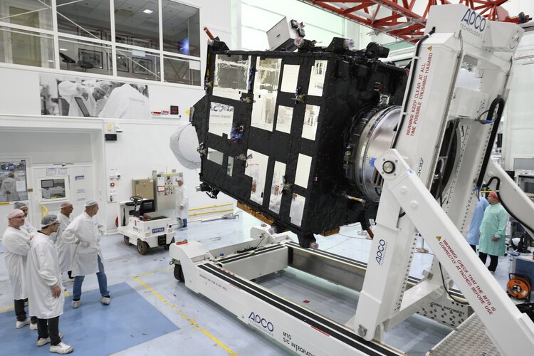 Video:
00:04:04
Video:
00:04:04
The final pre-launch preparations for the first Meteosat Third Generation (MTG) satellite are underway. The first satellite, called MTG-I1, built by a European industrial consortium led by Thales Alenia Space carries two imagers: an advanced Flexible Combined Imager and, in a first for Europe, a Lightning Imager that will allow the earlier detection of storms and extreme weather events, as well as improve aviation safety.
Building on the long-standing partnership between ESA and Eumetsat, the MTG-I1 will be one of six satellites operating in a fleet, of three at a time, to ensure the continuity of data from the previous Meteosat satellites over the next 20 years. The first Meteosat was launched in 1977 and this third generation of spacecraft will be the most advanced yet, with improved image resolution and providing close to real time data for users, or ‘nowcasting’ of fast-developing, high-impact weather.
The launch is currently scheduled for the end of 2022.
The film includes soundbites from ESA Director of Earth Observation Programmes: Simonetta Cheli, ESA Meteosat Programme Manager: Paul Blythe, ESA Meteosat Third Generation Payload Manager: Donny Aminou and EUMETSAT, Meteosat Third Generation Programme Manager: Alexander Schmid.
Earth from Space: Lake Trasimeno
23.9.2022 10:00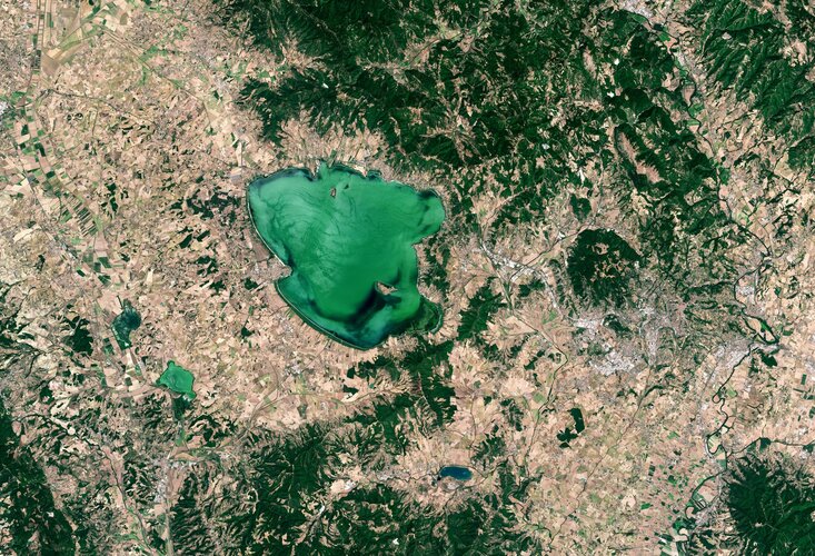
Lake Trasimeno, the fourth largest lake in Italy, is featured in this week’s Earth from Space image.
ESA selects Harmony as tenth Earth Explorer mission
22.9.2022 16:20
Following preparatory activities and a stringent process ESA Member States today formally selected Harmony for implementation as the tenth Earth Explorer mission within the FutureEO programme . This unique satellite mission concept is, therefore, now set to become a reality to provide a wealth of new information about our oceans, ice, earthquakes and volcanoes – which will make significant contributions to climate research and risk monitoring.
ESA selects Harmony as tenth Earth Explorer mission
22.9.2022 16:20
Following preparatory activities and a stringent process ESA Member States today formally selected Harmony for implementation as the tenth Earth Explorer mission within the FutureEO programme. This unique satellite mission concept is, therefore, now set to become a reality to provide a wealth of new information about our oceans, ice, earthquakes and volcanoes – which will make significant contributions to climate research and risk monitoring.
Mediterranean Sea hit by marine heatwave
22.9.2022 13:20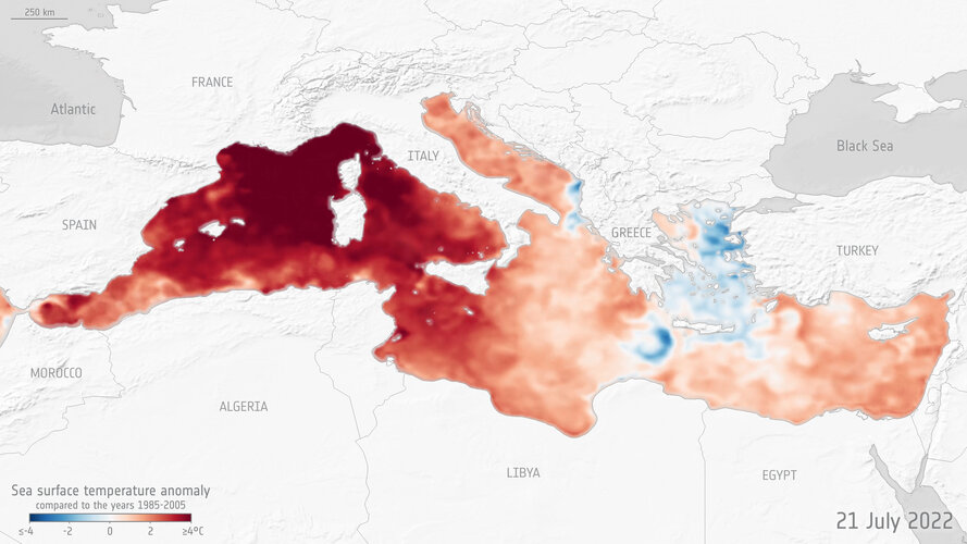
Many parts of Europe saw record-breaking temperatures over the summer, but it wasn’t just the continental mainland that was affected: the Mediterranean Sea also suffered a major marine heatwave. An ESA-funded project, CAREHeat, detected one of the most intense Mediterranean marine heatwaves observed during the satellite era – with sea surface temperatures reaching 5°C higher than average.
Zooming in on drought from space
21.9.2022 10:20
We are all aware that the summer of 2022 has been one of the hottest on record, causing drought and raging wildfires in many parts of Europe. Satellite data have been used to report the baking temperatures of the land surface and map fires, but the Copernicus Sentinel-1 radar mission has also been used to zoom in and provide very high-resolution measurements of the actual moisture content of the surface soils. Maps of northern Italy, for example, show how dry this summer has been compared to two years ago.
How do satellites monitor the ozone layer?
16.9.2022 14:25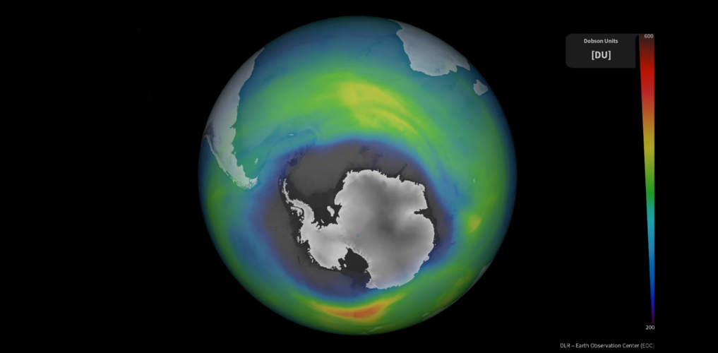
The ozone layer in our upper atmosphere protects Earth from the harmful effects of ultraviolet radiation. The use of human-produced chemicals in our atmosphere used for many years depleted Earth’s ozone layer. However, the reduction in the consumption of ozone-depleting substances driven by the Montreal Protocol – an international treaty designed to protect the ozone layer – has allowed for the ozone hole to slowly recover. This global agreement demonstrates the power of international commitment and immediate global action in protecting our environment.
ESA has been involved in monitoring the ozone for over two decades. Today, 16 September, marks the International Day for the Preservation of the Ozone Layer and we take a closer look at how satellite instruments carefully monitor the ozone layer over the South Pole.
Earth from Space: UK heatwave
16.9.2022 10:00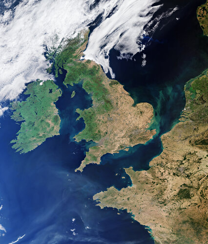
This summer, heatwaves struck Europe, North Africa, the US and Asia with temperatures reaching over 40°C in places – breaking many long-standing records. Images from the Copernicus Sentinel-3 mission show the scale of Britain’s heatwave as it baked in extreme temperatures in August.
Taking the dazzle out of CryoSat yields a first
14.9.2022 17:00
Since it was launched more than 12 years ago, ESA’s CryoSat ice mission has dazzled by way of its sheer technological and scientific excellence. This superb Earth Explorer satellite has returned a wealth of information that has transformed our understanding of Earth’s ice and how it is responding to climate change. In some circumstances, however, being dazzled isn’t a good thing, particularly when it comes to measuring the height of sea ice from space during the summer.
A paper published in Nature describes how scientists have now found an ingenious way of removing the pesky problem of dazzle from surface meltwater to yield the first ever continuous, year-round, altimetry measurements of sea-ice thickness in the Arctic Ocean.
Media invitation: International Astronautical Congress 2022 in Paris
13.9.2022 9:33Press Release N° 46–2022
The International Astronautical Congress 2022 (IAC) will be hosted in Paris, France, from Sunday to Thursday, 18-22 September 2022, at the Paris Convention Centre (1 place de la Porte de Versailles, 75015 Paris).
MTG-I1 weather satellite shows off
9.9.2022 9:33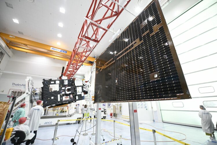
Before Europe’s first Meteosat Third Generation Imager leaves the south of France at the end of the month aboard a ship bound for French Guiana, this remarkable new weather satellite has been taking centre stage at Thales Alenia Space’s facilities in Cannes.
ESA–EGU Excellence Award 2023 open for nominations
7.9.2022 14:00
Following the success of the inaugural ESA–EGU Earth Observation Excellence Award in 2021, it’s now time to lodge your nomination for someone or for a team that deserves recognition for their innovative use of Earth observation. The call for nomination opens today and will close on 7 December.
The award winners will be announced and presented at the European Geosciences Union (EGU) General Assembly, which takes place on 23–28 April 2023.
Pakistan inundated
1.9.2022 12:02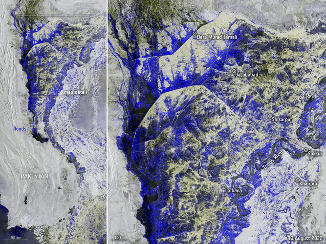 Image:
Data captured from space by Copernicus Sentinel-1 on 30 August was used to map the extent of flooding that is currently devastating Pakistan.
Image:
Data captured from space by Copernicus Sentinel-1 on 30 August was used to map the extent of flooding that is currently devastating Pakistan.
Pakistan inundated
1.9.2022 9:02
Image:
Captured from space by Copernicus Sentinel-1 on 30 August 2022, this image shows the extent of flooding that is currently devastating Pakistan. Heavy monsoon rainfall has led to more than a third of the country now being underwater.
Pakistan inundated
1.9.2022 9:02
Image:
Data captured from space by Copernicus Sentinel-1 on 30 August was used to map the extent of flooding that is currently devastating Pakistan .Heavy monsoon rainfall has led to more than a third of the country now being underwater.
Drought causes Yangtze to shrink
24.8.2022 10:25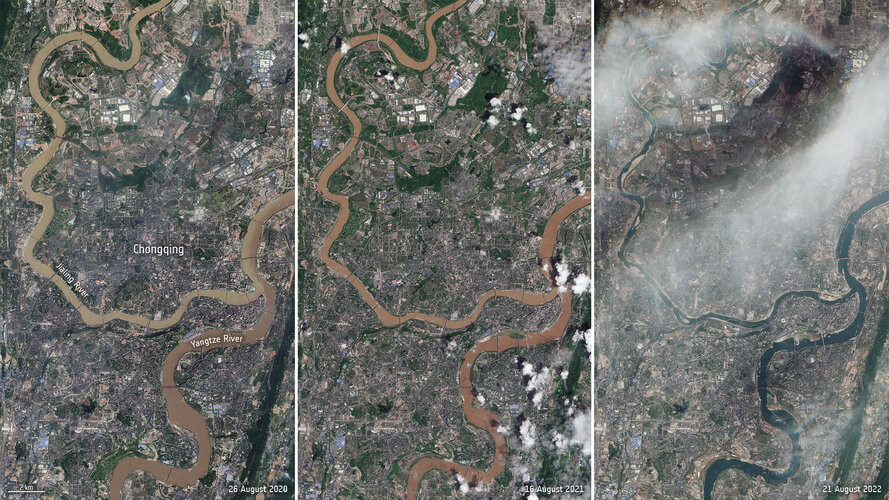 Image:
A record-breaking drought has caused parts of the Yangtze River to dry up – affecting hydropower, shipping routes and limiting drinking water supplies. Images captured by the Copernicus Sentinel-2 mission show a comparison of the Yangtze and Jialing rivers, near Chongqing, over the last three years.
Image:
A record-breaking drought has caused parts of the Yangtze River to dry up – affecting hydropower, shipping routes and limiting drinking water supplies. Images captured by the Copernicus Sentinel-2 mission show a comparison of the Yangtze and Jialing rivers, near Chongqing, over the last three years.
Heatwaves and climate change
18.8.2022 11:00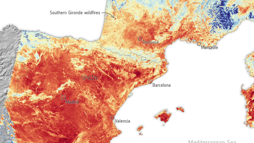 Video:
00:02:50
Video:
00:02:50
The series of heatwaves we are currently experiencing in western Europe is a clear sign of human-induced global warming. ESA’s Clement Albergel explains how we monitor these events using satellites such as the Copernicus Sentinel-3 mission and puts them in the context of the long-term climate data record generated via ESA’s Climate Change Initiative.
Rhine river runs dry
17.8.2022 12:20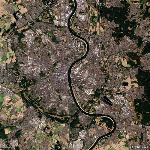 Image:
Water levels on the Rhine River have continued to drop owing to soaring temperatures and lack of rainfall - preventing many vessels from navigating through the river's waters at full capacity. These Copernicus Sentinel-2 images show the stark difference between August 2021 and August 2022.
Image:
Water levels on the Rhine River have continued to drop owing to soaring temperatures and lack of rainfall - preventing many vessels from navigating through the river's waters at full capacity. These Copernicus Sentinel-2 images show the stark difference between August 2021 and August 2022.
Invitation to media – Viewing Europe’s MTG-I weather satellite before launch in Cannes
9.8.2022 16:03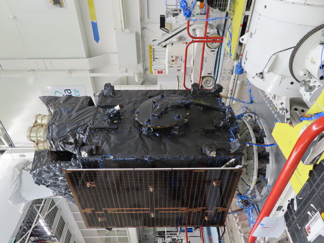
Call for Media: view MTG-I weather satellite before launch
Mission ends for Copernicus Sentinel-1B satellite
3.8.2022 11:00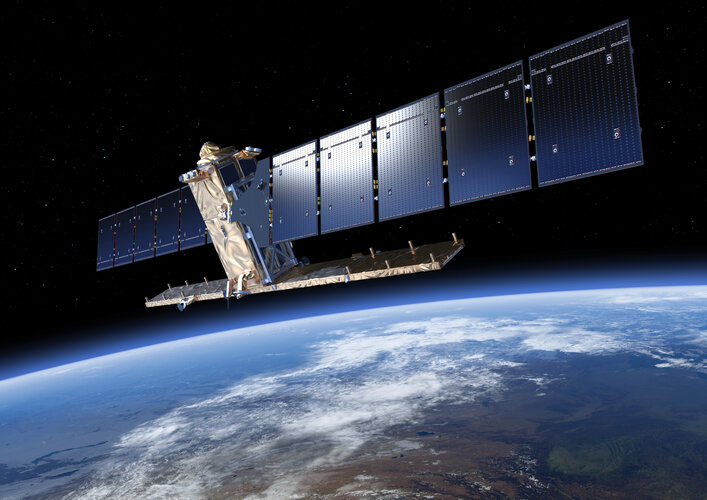
On 23 December 2021, Copernicus Sentinel-1B experienced an anomaly related to the instrument electronics power supply provided by the satellite platform, leaving it unable to deliver radar data. Since then spacecraft operators and engineers have been working tirelessly to rectify the issue. Unfortunately, despite all concerted efforts, ESA and the European Commission announce that it is the end of the mission for Sentinel-1B. Copernicus Sentinel-1A remains fully operational and plans are in force to launch Sentinel-1C as soon as possible.
Utah’s Great Salt Lake is disappearing
1.8.2022 17:20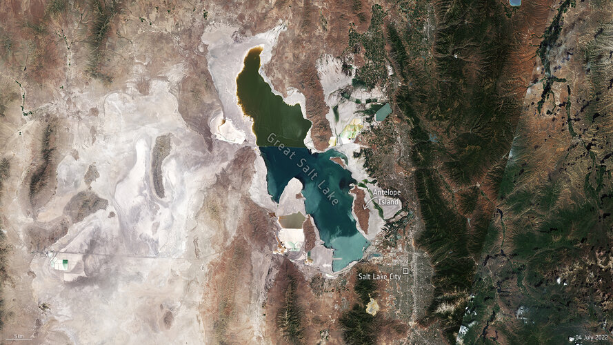
Utah’s Great Salt Lake dropped to its lowest recorded water level last month as a megadrought persists across the US southwest, forcing the fast-growing city to curb its water use. From space, satellite images show how water levels have fallen from 1985 to 2022 – exposing large expanses of lakebed.
Operation centres in tune for upcoming weather satellite
28.7.2022 15:40
In just a few months’ time Europe’s first Meteosat Third Generation satellite will soar into the skies on an Ariane 5 rocket from French Guiana. From geostationary orbit, this new satellite, carrying two new highly sensitive instruments, will take weather forecasting to the next level. Taking a significant step towards launch, the satellite operations teams at two different centres have completed an all-important suite of tests ensuring that their procedures are fully compatible with the satellite.
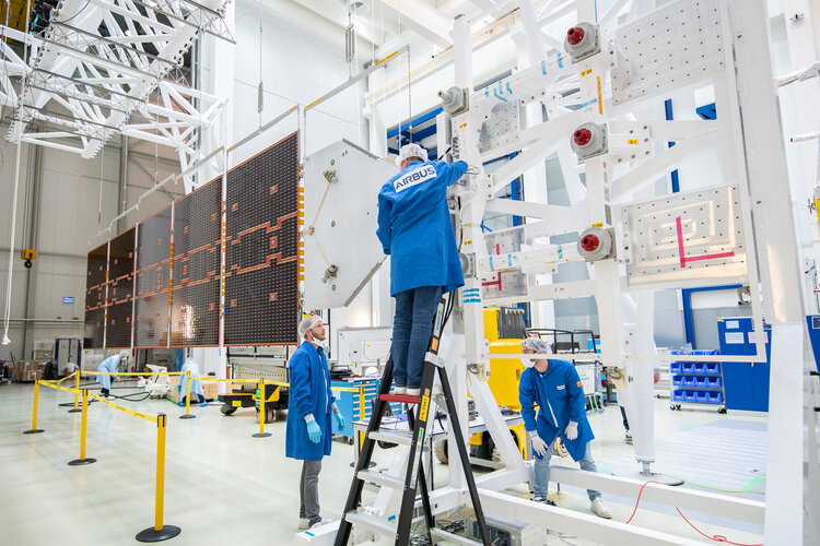 Image:
EarthCARE taking wing
Image:
EarthCARE taking wing
Tap into Europe in motion
26.7.2022 14:48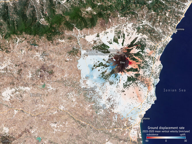
Any movement beneath our feet – from barely perceptible subsidence to the sudden appearance of a sinkhole or a crashing landslide – spells big trouble. Even relatively modest subsidence can weaken buildings and infrastructure and lead to issues such as flooding, and at worst the abrupt disappearance of sections of land brings immediate threat to life. Monitoring and predicting our shifting land is clearly essential for adopting mitigating strategies.
And now, thanks to Europe’s environmental Copernicus programme and the Sentinel-1 radar satellite mission, the first Europe-wide subsidence and soil movement analysis service is available to the public.
Greece battles wildfires on Lesbos island
25.7.2022 16:36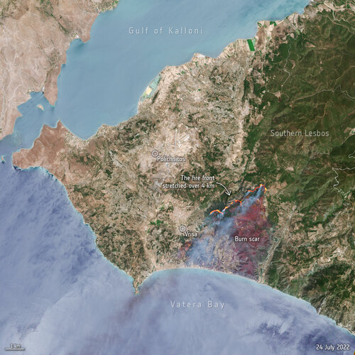 Image:
Hundreds of residents and tourists have been evacuated from the Greek island of Lesbos after a wildfire broke out on the morning of 23 July. This image, captured by Sentinel-2, shows the active fire front which stretches for more than four km.
Image:
Hundreds of residents and tourists have been evacuated from the Greek island of Lesbos after a wildfire broke out on the morning of 23 July. This image, captured by Sentinel-2, shows the active fire front which stretches for more than four km.
EarthCARE takes a big stretch
21.7.2022 13:04
ESA’s upcoming EarthCARE satellite mission has just taken a big stretch. Engineers have gently unfolded this new satellite’s huge five-panel solar wing to test that it will deploy correctly once it is in space. The solar wing is a critical part of the satellite, providing the energy for EarthCARE to do its job: to quantify the role that clouds and aerosols play in heating and cooling Earth’s atmosphere.
TRUTHS shines
20.7.2022 14:00
Satellites are essential for delivering key data to understand and monitor how the climate crisis is impacting our world, but, in turn, decision-makers need to be confident in the data they use for mitigation strategies and policymaking. TRUTHS, a new ESA mission, will do just this – and, now having passed an important milestone, it is one step closer to becoming a reality.
Feeling the heat from space
20.7.2022 9:49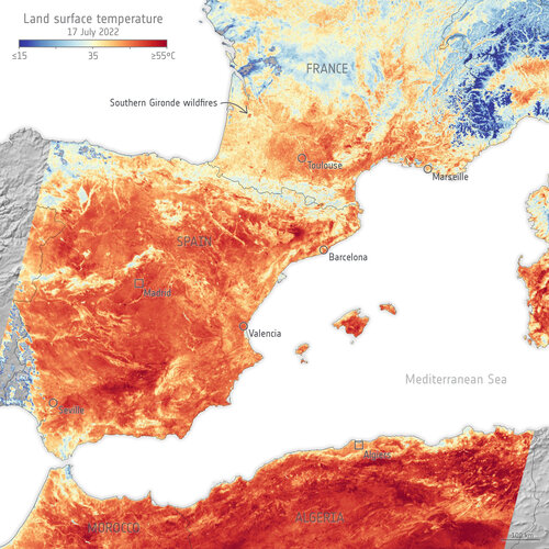
With searing temperatures and a string of record highs being smashed across western Europe, the current heatwave is all too apparent. Extreme heat warnings have been issued in several countries including France, Spain and Portugal, and deadly wildfires have forced thousands to flee their homes. The satellite images here are an example of how the crisis is being viewed by satellites orbiting Earth.
Wildfire near Salamanca: before-and-after
15.7.2022 15:00 Image:
These Copernicus Sentinel-2 images, one year apart, show the area affected by wildfire around Las Batuecas - Sierra de Francia Nature Reserve near Salamanca in western Spain.
Image:
These Copernicus Sentinel-2 images, one year apart, show the area affected by wildfire around Las Batuecas - Sierra de Francia Nature Reserve near Salamanca in western Spain.
Earth from Space: Fuerteventura and Lanzarote
8.7.2022 10:00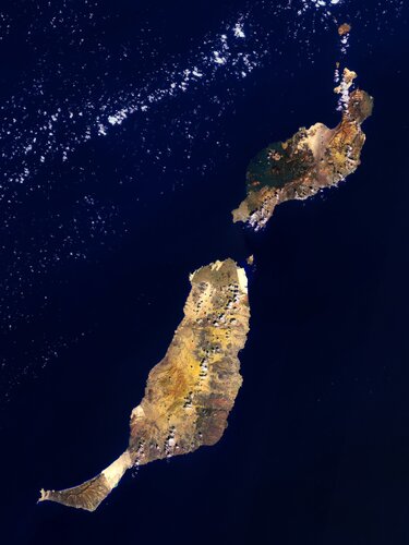
Fuerteventura and Lanzarote, part of the Canary Islands lying in the North Atlantic Ocean, are featured in this false-colour image captured by the Copernicus Sentinel-2 mission.
User Consultation Meeting on Harmony: watch the replay
6.7.2022 15:00
User Consultation Meeting on Harmony: watch the replay
Follow the discussions on Harmony – the candidate mission for ESA’s tenth Earth Explorer
City heat extremes
6.7.2022 13:30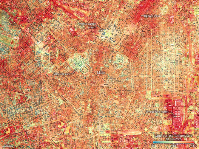
With air temperatures in excess of 10°C above the average for the time of year in parts of Europe, the United States and Asia, June 2022 has gone down as a record breaker. The fear is that these extreme early-season heatwaves are a taste of what could soon be the norm as climate change continues to take hold. For those in cities, the heat dissipates slower creating ‘urban heat islands’, which make everyday life even more of a struggle.
An instrument, carried on the International Space Station, has captured the recent land-surface temperature extremes for some European cities, including Milan, Paris and Prague.
Watch: Earth Explorer 10 Consultation
4.7.2022 12:30
Watch: Earth Explorer 10 Consultation
On 5 July, follow the discussion on Harmony at the User Consultation Meeting for ESA's tenth Earth Explorer
Earth from Space: Patagonia
1.7.2022 10:00
The Copernicus Sentinel-3 mission captured this impressive, wide-angled view of Patagonia at the southern end of South America, as well as the Falkland Islands.
Earth from Space: Patagonia
1.7.2022 10:00
The Copernicus Sentinel-3 mission captured this impressive, wide-angled view of Patagonia at the southern end of South America, as well as the Falkland Islands (Malvinas).
Copernicus Sentinel-1 maps Bangladesh flood
30.6.2022 17:00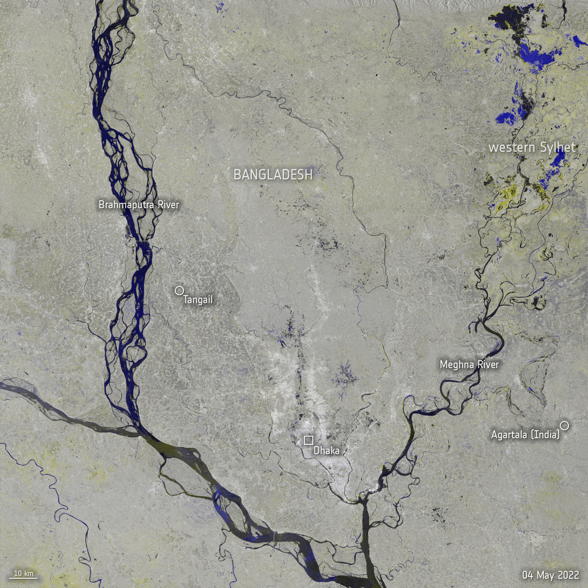 Image:
Copernicus Sentinel-1 maps Bangladesh flood
Image:
Copernicus Sentinel-1 maps Bangladesh flood
Tenoumer Crater, Mauritania
30.6.2022 10:00 Image:
Deep within the Sahara Desert lies one of the best-preserved craters on Earth. On Asteroid Day, the Copernicus Sentinel-2 mission takes us over the almost-perfectly circular Tenoumer Crater in Mauritania.
Image:
Deep within the Sahara Desert lies one of the best-preserved craters on Earth. On Asteroid Day, the Copernicus Sentinel-2 mission takes us over the almost-perfectly circular Tenoumer Crater in Mauritania.
Contract secures design for ESA’s FORUM satellite
28.6.2022 9:00
ESA has awarded a contract worth €160 million to Airbus in the UK to build the Earth Explorer FORUM satellite. This exciting new mission will yield unique insight into the planet’s radiation budget and how it is controlled – thereby filling in a critical missing piece of the climate jigsaw.
Short for Far-infrared Outgoing Radiation Understanding and Monitoring, FORUM is ESA’s ninth Earth Explorer mission.
Po River dries up
27.6.2022 9:30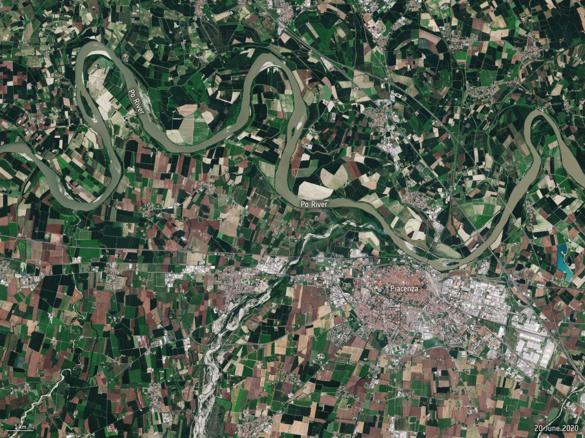 Image:
The Po River, the longest river in Italy, is hitting record low water levels after months without heavy rainfall. This Copernicus Sentinel-2 animation reveals how the river has significantly shrunk between June 2020 and June 2022.
Image:
The Po River, the longest river in Italy, is hitting record low water levels after months without heavy rainfall. This Copernicus Sentinel-2 animation reveals how the river has significantly shrunk between June 2020 and June 2022.
Earth from Space: Lake Balkhash
24.6.2022 10:00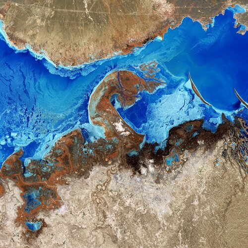
Lake Balkhash, the largest lake in Central Asia, is featured in this false-colour image captured by the Copernicus Sentinel-2 mission.
Earth from Space: Lake Balkhash
24.6.2022 10:00
Lake Balkhash, the largest lake in Central Asia, is featured in this false-colour image captured by the Copernicus Sentinel-2 mission.
Methane levels surged in 2020 despite lockdowns
23.6.2022 14:45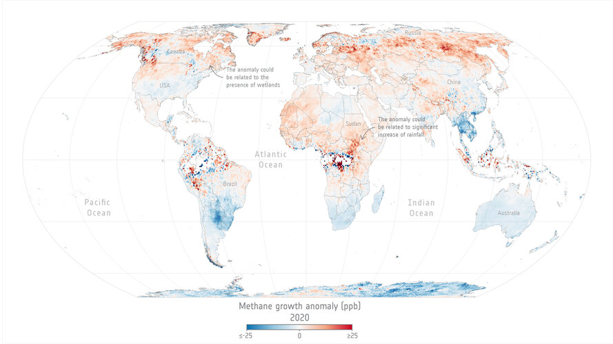
Levels of methane, the second most important greenhouse gas in our atmosphere, continued their unrelenting rise in 2020 despite the economic slowdown caused by the COVID-19 pandemic.
A team of scientists, from the University of Leeds, have used data from the Copernicus Sentinel-5P satellite to pinpoint locations with large surges of methane emissions. These findings were presented during ESA’s Living Planet Symposium which took place last month in Bonn, Germany.
Earth from Space: Glacier Bay, Alaska
17.6.2022 10:00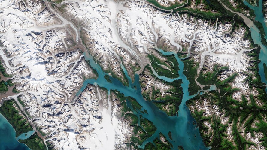
Part of the Glacier Bay National Park and Preserve, which lies along the coast of southeast Alaska, is featured in this image captured by the Copernicus Sentinel-2 mission.
Earth from Space: Singapore
10.6.2022 10:00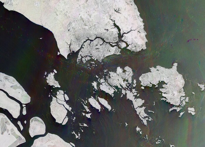
This radar image, captured by the Copernicus Sentinel-1 mission, shows us the only city-island-nation – Singapore – and one of the busiest ports in the world.
Earth from Space: Singapore
10.6.2022 10:00
This radar image, captured by the Copernicus Sentinel-1 mission, shows us the only city-island-nation – Singapore – and one of the busiest ports in the world.
Methane emissions detected over offshore platform in the Gulf of Mexico
9.6.2022 16:30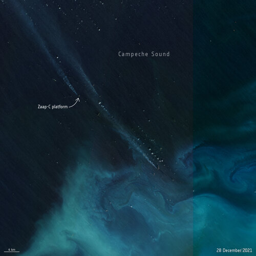
A team of scientists have used satellite data to detect methane plumes from an offshore platform in the Gulf of Mexico. This is the first time that individual methane plumes from offshore platforms are mapped from space.
Charting sea level from space
8.6.2022 16:00 Video:
00:12:21
Video:
00:12:21
Satellite images of our planet have become essential to our survival, offering a new outlook of our world. With rising seas being one of the biggest threats to society, satellite altimeter missions such as Copernicus Sentinel-6 are essential in monitoring global and regional changes in sea level.
Unbeknown to many, the island of Crete, Greece, plays an important role in the Copernicus satellite altimetry constellation and on an international stage. Satellite altimetry data have to be continuously monitored at the ESA’s Permanent Facility for Altimetry Calibration where different techniques have pioneered the use of transponders to provide the best measurements to validate satellite altimeters in space soon after launch.
This documentary explains how measurements are taken from the top of the White Mountains to make sure users get the best data on sea height from satellite altimetry.
It features interviews with Craig Donlon, Head of ESA’s Earth Surfaces and Interior Earth and Mission Science Division and Stelios Mertikas, Director of Laboratory of Geodesy & Geomatics Engineering at the Technical University of Crete.
Earth from Space: Puglia, Italy
3.6.2022 10:00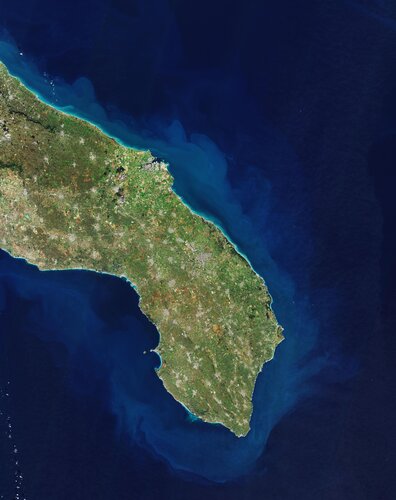
Part of Puglia, or Apulia, a region in southern Italy, is featured in this image captured by the Copernicus Sentinel-2 mission.
Revisit Living Planet Symposium: watch session replays
30.5.2022 11:00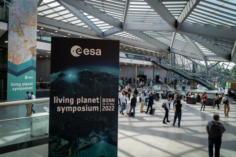
Revisit Living Planet Symposium: watch session replays
Living Planet concludes with record numbers
27.5.2022 13:42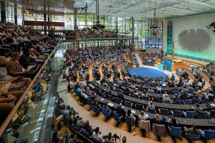
With more than 5000 participants, 240 science sessions and over 1300 oral presentations, ESA’s Living Planet Symposium comes to a close with record-breaking numbers. Held on 23-27 May at the World Conference Center in the German city of Bonn, the symposium brought together world-class scientists, business leaders, representatives from space agencies and international organisations and industry from around the world. Throughout the week, they showcased the latest advances in Earth observation and highlighted the essential role of Earth observation for decision making regarding the ongoing climate crisis. As the week draws to a close, we look back at some of the highlights of the week.
Boosting commercial Earth observation
27.5.2022 11:45
One of the objectives of the Living Planet Symposium, taking place this week in Bonn, is to foster interaction between the institutional and commercial sectors to boost the Earth observation space economy. This is being achieved by highlighting existing partnerships, expanding the number of data users and facilitating access to private funds for companies.
Oceans and Climate
26.5.2022 17:15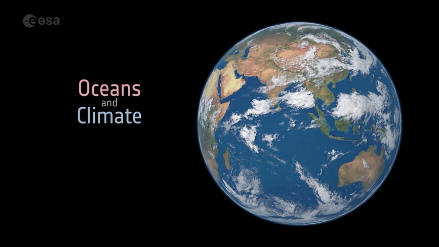 Video:
00:03:33
Video:
00:03:33
Earth’s oceans are huge heat stores, soaking up 93% of the excess heat from human activity over the past 70 years. Ocean currents redistribute heat around the planet, from the Equator to the poles. Where this ocean heat goes influences weather patterns and regional climate. As well as absorbing heat, oceans are a natural carbon sink, absorbing a quarter of carbon dioxide emissions from human activity. This has led to the acidification of ocean water, threating marine life.
The amount of heat and carbon dioxide absorbed depends on a number of ocean variables, all of which can be measured from space.