


![]()

ESA Observing the Earth 
zdroje zpráv:
Earth from Space: Seychelles
26.4.2024 10:00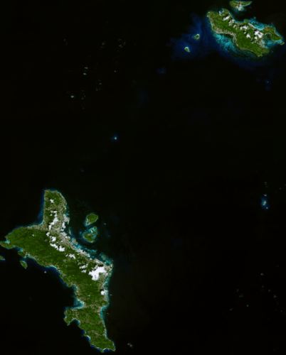 Image:
The Copernicus Sentinel-2 mission takes us over part of the Seychelles, an island republic in the western Indian Ocean.
Image:
The Copernicus Sentinel-2 mission takes us over part of the Seychelles, an island republic in the western Indian Ocean.
From space to soil
24.4.2024 9:50
Soil sealing might not be a term that everyone's familiar with, but its effects are felt far and wide, particularly in urban areas.
Recognising the urgencies of addressing soil sealing and its associated challenges, an ESA-funded project, Ulysses, is offering insights into the extent and severity of soil sealing to mitigate soil degradation in the Mediterranean region.
10 ways Earth is interconnected
22.4.2024 8:55
On this Earth Day, we reflect on the importance of protecting our planet for future generations. Understanding the Earth system and the complex interactions that shape our planet is paramount for addressing environmental challenges, mitigating climate change, preparing for natural disasters, managing resources sustainably and conserving biodiversity.
Each component of the Earth system – from the atmosphere and oceans to land surfaces and ice sheets – influences and interacts with one another in complex ways. ESA works all-year round to provide satellite data to monitor the health of our planet. Here are 10 examples of how Earth’s systems intertwine and how satellite measurements are key to understanding these complex processes.
Destination Earth goes live
19.4.2024 14:00
Destination Earth goes live
Watch the official launch event live on 10 June
Destination Earth goes live
19.4.2024 14:00
Destination Earth goes live
Watch the event broadcast live from Finland on 10 June
 Image:
Earth from Space: The Mekong Delta
Image:
Earth from Space: The Mekong Delta
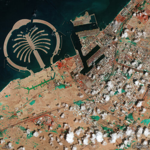 Image:
Dubai floods seen from space
Image:
Dubai floods seen from space
Earth Observation Excellence Award 2024 winner
18.4.2024 14:04
Celebrating the outstanding efforts of scientists and researchers who have advanced the innovative application of Earth observation data, ESA proudly announces the recipient of this year's esteemed Excellence Award. Dr Iestyn Woolway, from Bangor University in the UK, wins the 2024 Earth Observation Excellence Award.
Φsat-2 gets two new AI apps
18.4.2024 9:10
Φsat-2, ESA’s groundbreaking cubesat scheduled for launch in June, will now include two new AI-driven apps destined to demonstrate a crucial role in future environmental monitoring from space. The apps, which focus on marine pollution and wildfires, were the winning entries in ESA’s OrbitalAI Challenge.
ESA selects four new Earth Explorer mission ideas
17.4.2024 14:00
As humans exert greater pressure on natural processes, understanding the intricate workings of our Earth system is increasingly vital for effective action on mitigation and adaption strategies. ESA’s Earth Explorer missions yield a wealth of astonishing findings, serving as the bedrock of scientific research in this field. Now, four new concepts have been selected to undergo assessment study, one of which is destined to be the twelfth in this family of world-leading satellite missions.
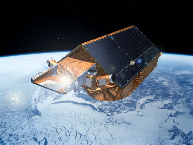
EarthCARE out of the box
16.4.2024 9:00
After being packed up in Germany, a long voyage to the US and then a month in storage, ESA’s EarthCARE satellite has been carefully lifted out of its transport container so that the team at the launch site can start getting it ready for its big day in May.
Earth from Space: The Ebro Delta
12.4.2024 10:00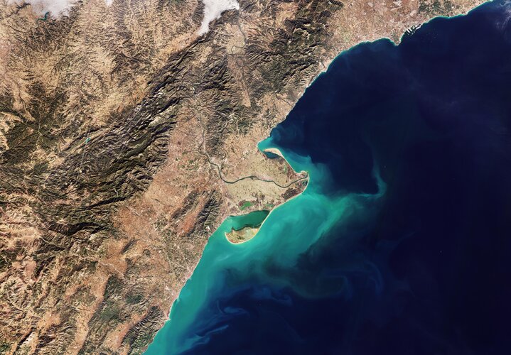 Image:
This Copernicus Sentinel-2 image shows the delta of the Ebro River on the northeast coast of Spain.
Image:
This Copernicus Sentinel-2 image shows the delta of the Ebro River on the northeast coast of Spain.
Total solar eclipse seen from space
9.4.2024 11:00 Video:
00:00:07
Video:
00:00:07
A total solar eclipse swept across North America yesterday, blocking out the Sun momentarily with parts of the continent plunged into darkness. Geostationary satellites orbiting 36 000 km away captured images of the rare celestial event.
These images, captured by the Geostationary Operational Environmental Satellite (GOES-16), captured the moon’s shadow moving across North America from approximately 16:00 to 23:00 CEST (15:00 to 22:00 BST.)
A total solar eclipse occurs when the Moon passes between the Sun and Earth and, for a short period, blocks the face of the Sun, save for a visible ring of light, known as the Sun’s corona.
The track of the moon’s shadow across Earth’s surface, called the path of totality, spanned across the North American continent – from Mexico to the very eastern tip of Canada.
The GOES series is a collaborative development and acquisition effort between National Oceanic and Atmospheric Administration (NOAA) and NASA. The GOES-16 (GOES-East) satellite, the first of the series, provides continuous imagery and atmospheric measurements of Earth's western hemisphere and monitors space weather.
The Copernicus Sentinel-3 mission also captured images of the eclipse with its Sea and Land Surface Temperature Radiometer (SLSTR).
The eclipse also acts as a laboratory for researching what happens to weather when the Moon’s shadow passes over. The shadow makes air temperatures drop and can cause clouds to evolve in different ways. Data from GOES, Sentinel-3 and other satellites are now being used to explore these effects.
Earth from Space: Victoria, Australia
5.4.2024 10:00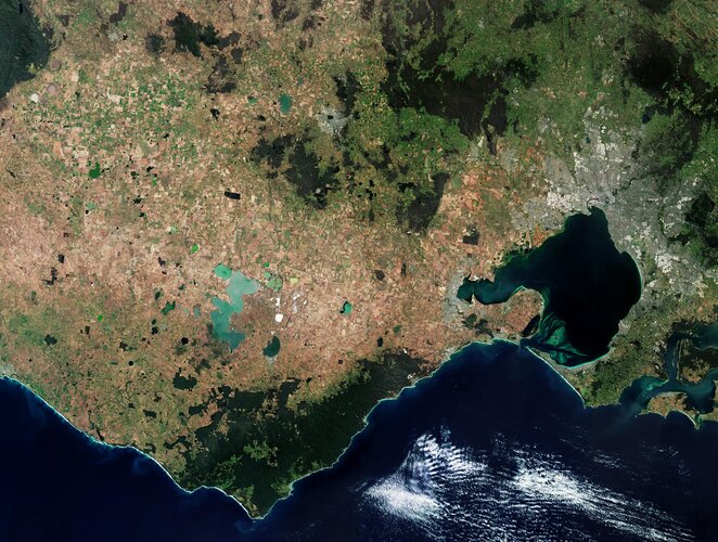 Image:
This Copernicus Sentinel-2 image features part of Victoria, a state in southeast Australia.
Image:
This Copernicus Sentinel-2 image features part of Victoria, a state in southeast Australia.
All eyes on the Arctic Weather Satellite
4.4.2024 11:50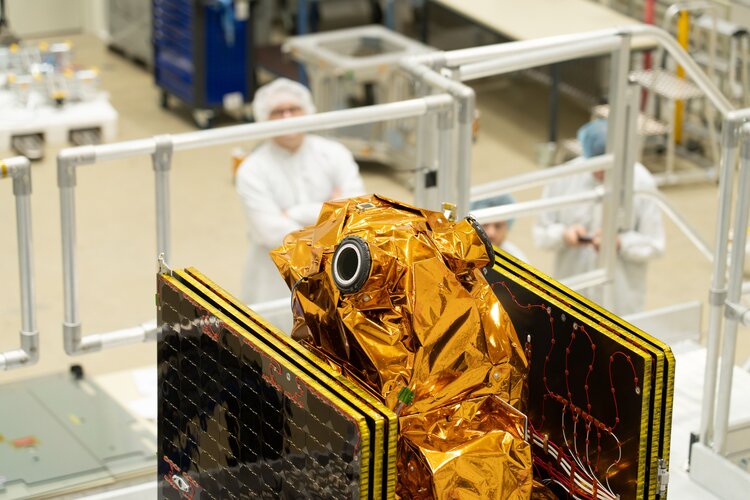
ESA’s new Arctic Weather Satellite has taken centre stage at OHB’s facilities in Stockholm, Sweden, before the spacecraft is packed up and shipped to California, US, for a launch currently scheduled for June.
Embracing the New Space approach to demonstrate new concepts in a cost-effective and timely manner, the Arctic Weather Satellite has been designed to show how it can improve weather forecasts in the Arctic.
Saharan dust plume
3.4.2024 15:40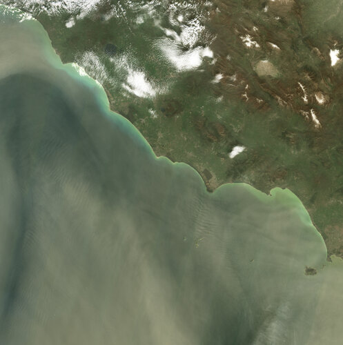 Image:
Images from the Copernicus Sentinel-2 mission show a large dust storm originating from the Sahara Desert that has engulfed skies across the central Mediterranean Basin.
Image:
Images from the Copernicus Sentinel-2 mission show a large dust storm originating from the Sahara Desert that has engulfed skies across the central Mediterranean Basin.
Earth from Space: The Amazon plume
29.3.2024 10:00 Image:
The Copernicus Sentinel-3 mission takes us over northern Brazil, where the Amazon River meets the Atlantic Ocean.
Image:
The Copernicus Sentinel-3 mission takes us over northern Brazil, where the Amazon River meets the Atlantic Ocean.
Vegetation gets a boost with data from space
27.3.2024 9:40
When it comes to predicting what our climate will be like in the future, vegetation matters. Plants and trees exert a powerful influence over both the energy cycle and the water cycle. And, crucially, it is estimated that vegetation draws down well over three billion tonnes of carbon from the atmosphere each year – this is equivalent to a third of greenhouse gas emissions from human activity.
Accounting for vegetation growth is clearly important in the complex climate puzzle – and the release of a new satellite dataset is set to help climate modellers with the challenge of evaluating the impacts of climate change.
Vegetation gets a boost with data from space
27.3.2024 9:40
When it comes to predicting what our climate will be like in the future, vegetation matters. Plants and trees exert a powerful influence over both the energy cycle and the water cycle. And, crucially, it is estimated that vegetation draws down well over three billion tonnes of carbon from the atmosphere each year – this is equivalent to a third of greenhouse-gas emissions from human activity.
Accounting for vegetation growth is clearly important in the complex climate puzzle – and the release of a new satellite dataset is set to help climate modellers with the challenge of evaluating the impacts of climate change.
SMOS and Swarm team up to spot huge solar storm
26.3.2024 10:30
The Sun erupted over the weekend, flinging electromagnetic radiation towards Earth, even illuminating skies with spectacular aurora borealis. For the first time, ESA’s unlikely space weather duo of SMOS and Swarm tracked the severe solar storm — which warped Earth’s magnetic field.
Building ChatGPT-style tools with Earth observation
25.3.2024 9:27
Imagine being able to ask a chatbot, “Can you make me an extremely accurate classification map of crop cultivation in Kenya?” or “Are buildings subsiding in my street?” And imagine that the information that comes back is scientifically sound and based on verified Earth observation data.
ESA, in conjunction with technology partners, is working to make such a tool a reality by developing AI applications that will revolutionise information retrieval in Earth observation.
Earth from Space: Southeast Kenya
22.3.2024 10:00 Image:
The striking contrast of the diverse landscape in southeast Kenya is featured in this false-colour image captured by Copernicus Sentinel-2.
Image:
The striking contrast of the diverse landscape in southeast Kenya is featured in this false-colour image captured by Copernicus Sentinel-2.
Media invitation: Last chance to see Arctic Weather Satellite
21.3.2024 17:02
Call for media: Last chance to see Arctic Weather Satellite
Toward the next generation of air quality monitoring
21.3.2024 16:00 Video:
00:17:57
Video:
00:17:57
Air pollution is the largest environmental health risk in Europe and significantly impacts the health of the European population, particularly in urban areas.
Following on from the Sentinel-5P satellite – the first Copernicus mission dedicated to monitoring our atmosphere – the Sentinel-4 and Sentinel-5 missions will take current air quality measuring capabilities to the next level.
Together, the Sentinel-4 and -5 missions will provide information on atmospheric variables in support of European policies. This will include the monitoring of air quality, stratospheric ozone and solar radiation, and climate monitoring.
This video features interviews with Giorgio Bagnasco, Sentinel-4 Mission Project Manager, Ben Veilhelmann, Sentinel-4&5 Mission Scientist and Didier Martin, Sentinel-5 Mission Project Manager.
Earth from Space: Vienna, Austria
15.3.2024 10:00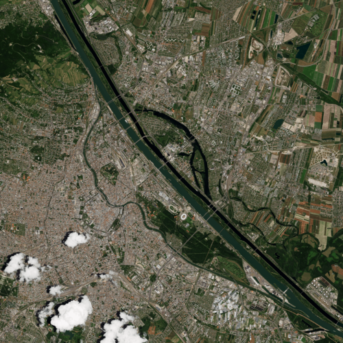 Image:
The historic centre of Vienna, Austria’s capital city, is featured in this image captured on 23 June 2023.
Image:
The historic centre of Vienna, Austria’s capital city, is featured in this image captured on 23 June 2023.
Taking Earth’s temperature from space
14.3.2024 16:00 Video:
00:14:13
Video:
00:14:13
Climate change exacerbates droughts by making them more frequent, longer, and more severe. This can have a wide range of impacts on the environment, agriculture, ecosystems and communities including water scarcity, crop failure and food shortages.
The upcoming Copernicus Land Surface Temperature Monitoring, LSTM, mission will improve sustainable agricultural productivity in a world of increasing water scarcity and variability.
The mission will carry a high spatial-temporal resolution thermal infrared sensor to provide observations of land-surface temperature.
These data are key to understand and respond to climate variability, manage water resources for agricultural production, predict droughts and also to address land degradation.
LSTM is one of six Copernicus Sentinel Expansion missions that ESA is developing on behalf of the EU. The missions will expand the current capabilities of the Copernicus Space Component – the world’s biggest supplier of Earth observation data.
This video features interviews with Ana Bolea Alamanac, LSTM Mission Project Manager, Ilias Manolis, LSTM Mission Payload Manager and Itziar Barat, LSTM Mission System and Operations Manager.
Taking Earth’s temperature from space
14.3.2024 16:00
Video:
00:14:13
Climate change exacerbates droughts by making them more frequent, longer, and more severe. This can have a wide range of impacts on the environment, agriculture, ecosystems and communities including water scarcity, crop failure and food shortages.
The upcoming Copernicus Land Surface Temperature Monitoring, LSTM, mission will improve sustainable agricultural productivity in a world of increasing water scarcity and variability.
The mission will carry a high spatial-temporal resolution thermal infrared sensor to provide observations of land-surface temperature.
These data are key to understand and respond to climate variability, manage water resources for agricultural production, predict droughts and also to address land degradation.
LSTM is one of six Copernicus Sentinel Expansion missions that ESA is developing on behalf of the EU. The missions will expand the current capabilities of the Copernicus Space Component – the world’s biggest supplier of Earth observation data.
This video features interviews with Ana Bolea Alamanac, LSTM Mission Project Manager, Ilias Manolis, LSTM Mission Payload Manager and Itziar Barat, LSTM Mission System and Operations Manager.
Access all "Unpacking Sentinels" videos.
Arctic Weather Satellite tested for life in orbit
14.3.2024 10:00
ESA’s Arctic Weather Satellite has passed its environmental test campaign with flying colours – meaning that the satellite has been declared fit for liftoff and its life in the harsh environment of space.
This new satellite, which is slated for launch in June, has been designed to show how it can improve weather forecasts in the Arctic – a region that currently lacks data for accurate short-term forecasts.
Joining forces on the complexities of clouds and aerosols
11.3.2024 14:30
In just a few months, ESA’s EarthCARE satellite will be lofted into orbit to fill in a piece of the complex climate puzzle – that piece being how clouds and aerosols, small particles such as dust suspended in the air, affect Earth’s energy balance.
With the climate crisis upon us, this information is needed more urgently than ever – so much so, that the science of clouds and aerosols has been prioritised by the European Commission and ESA as part of their new Earth System Science Initiative.
Earth from Space: Ireland
8.3.2024 10:00 Image:
The lush landscape of the island of Ireland and the coasts of Scotland, Wales and England, are pictured in this view from the Copernicus Sentinel-3 mission.
Image:
The lush landscape of the island of Ireland and the coasts of Scotland, Wales and England, are pictured in this view from the Copernicus Sentinel-3 mission.
New radar mission for Europe
7.3.2024 16:00 Video:
00:09:27
Video:
00:09:27
The upcoming Copernicus Radar Observation System for Europe in L-band (ROSE-L) will provide continuous day-and-night all-weather monitoring of Earth’s land, oceans and ice, and offer frequent observations of Earth’s surface at a high spatial resolution.
ROSE-L will carry an active phased array synthetic aperture radar instrument. The radar antenna will be the largest deployable planar antenna ever built measuring an impressive 40 sq m.
ROSE-L will deliver many benefits including essential information on forests and land cover, leading to improved monitoring of the terrestrial carbon cycle and carbon accounting.
The mission will also greatly extend our ability to monitor minute surface displacements and helping detect geohazards. It will automatically map surface soil moisture conditions over land helping improve hydrology and weather forecasts, and support the operational monitoring of sea and land ice across the Arctic.
ROSE-L is one of six Copernicus Sentinel Expansion missions that ESA is developing on behalf of the EU. The missions will expand the current capabilities of the Copernicus Space Component – the world’s biggest supplier of Earth observation data.
This video features interviews with Malcolm Davidson, ROSE-L Mission Scientist, Nico Gebert, ROSE-L Payload Manager and Gianluigi Di Cosimo, ROSE-L Project Manager.
EarthCARE bids adieu to Europe
7.3.2024 12:00 Video:
00:03:29
Video:
00:03:29
After years of development and a rigorous testing programme, ESA’s EarthCARE satellite has left Munich, Germany, and is now on its away to SpaceX’s launch site in Vandenberg, California. Once it arrives, it will be put into storage for a few weeks until it is time to ready the satellite for liftoff – which is scheduled to launch in May on a Falcon 9 rocket.
The Earth Cloud Aerosol and Radiation Explorer, or EarthCARE for short, is the most complex Earth Explorer mission to date. The new satellite will look at the role that clouds and aerosols play in heating and cooling Earth’s atmosphere – contributing to our understanding of climate change.
With its unique set of four instruments, EarthCARE will examine the role clouds and aerosols play in reflecting solar radiation back into space and also in trapping infrared radiation emitted from Earth’s surface.
EarthCARE is a joint venture between ESA and JAXA, the Japan Aerospace Exploration Agency.
This video features interviews with Simonetta Cheli, Director of Earth Observation Programmes at ESA, Thorsten Fehr, ESA’s EarthCARE Mission Scientist, Dirk Bernaerts, ESA’s EarthCARE Project Manager and Eiichi Tomita, JAXA’s EarthCARE/CPR Project Manager.
EarthCARE bids adieu to Europe
7.3.2024 12:00
Video:
00:03:29
After years of development and a rigorous testing programme, ESA’s EarthCARE satellite has left Munich, Germany, and is now on its away to SpaceX’s launch site in Vandenberg, California. Once it arrives, it will be put into storage for a few weeks until it is time to ready the satellite for liftoff – which is scheduled to launch in May on a Falcon 9 rocket.
The Earth Cloud Aerosol and Radiation Explorer, or EarthCARE for short, is the most complex Earth Explorer mission to date. The new satellite will look at the role that clouds and aerosols play in heating and cooling Earth’s atmosphere – contributing to our understanding of climate change.
With its unique set of four instruments, EarthCARE will examine the role clouds and aerosols play in reflecting solar radiation back into space and also in trapping infrared radiation emitted from Earth’s surface.
EarthCARE is a joint venture between ESA and JAXA, the Japan Aerospace Exploration Agency.
This video features interviews with Simonetta Cheli, Director of Earth Observation Programmes at ESA, Thorsten Fehr, ESA’s EarthCARE Mission Scientist, Dirk Bernaerts, ESA’s EarthCARE Project Manager and Eiichi Tomita, JAXA’s EarthCARE/CPR Project Manager.
Access the related broadcast quality video material through the links below
https://www.esa.int/esatv/Videos/2023/10/EarthCARE_animations
https://www.esa.int/esatv/Videos/2024/01/EarthCARE_interviews
https://www.esa.int/esatv/Videos/2022/07/Earthcare_Satellite_B-Rolls
Earth from Space: Dawson-Lambton Glacier home to penguins
1.3.2024 10:00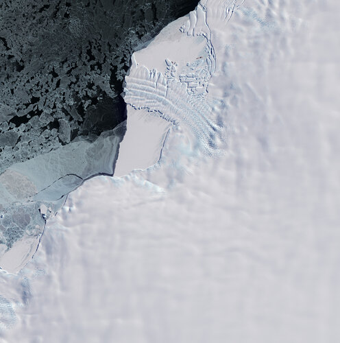 Image:
This Copernicus Sentinel-2 image features the ice tongue of the Dawson-Lambton Glacier in Antarctica.
Image:
This Copernicus Sentinel-2 image features the ice tongue of the Dawson-Lambton Glacier in Antarctica.
How will space transform the global food system?
29.2.2024 16:00According to the Food and Agriculture Organization (FAO), global agricultural production will need to increase by 60% by 2050 to meet the food demands of the growing global population.
A new satellite called Copernicus Hyperspectral Imaging Mission for the Environment, or CHIME, is being developed to support EU policies on the management of natural resources – ultimately helping to address the global issue of food security.
CHIME will carry a unique visible to shortwave infrared spectrometer to provide routine hyperspectral observations to support new and enhanced services for sustainable agricultural and biodiversity management, as well as soil property characterisation.
CHIME is one of six Copernicus Sentinel Expansion missions that ESA is developing on behalf of the EU. The missions will expand the current capabilities of the Copernicus Space Component – the world’s biggest supplier of Earth observation data.
This video features interviews with Marco Celesti, CHIME Mission Scientist and Jens Nieke, CHIME Project Manager.
Access all "Unpacking Sentinels" videos.
ERS-2 buckles and bends during final farewell
26.2.2024 10:20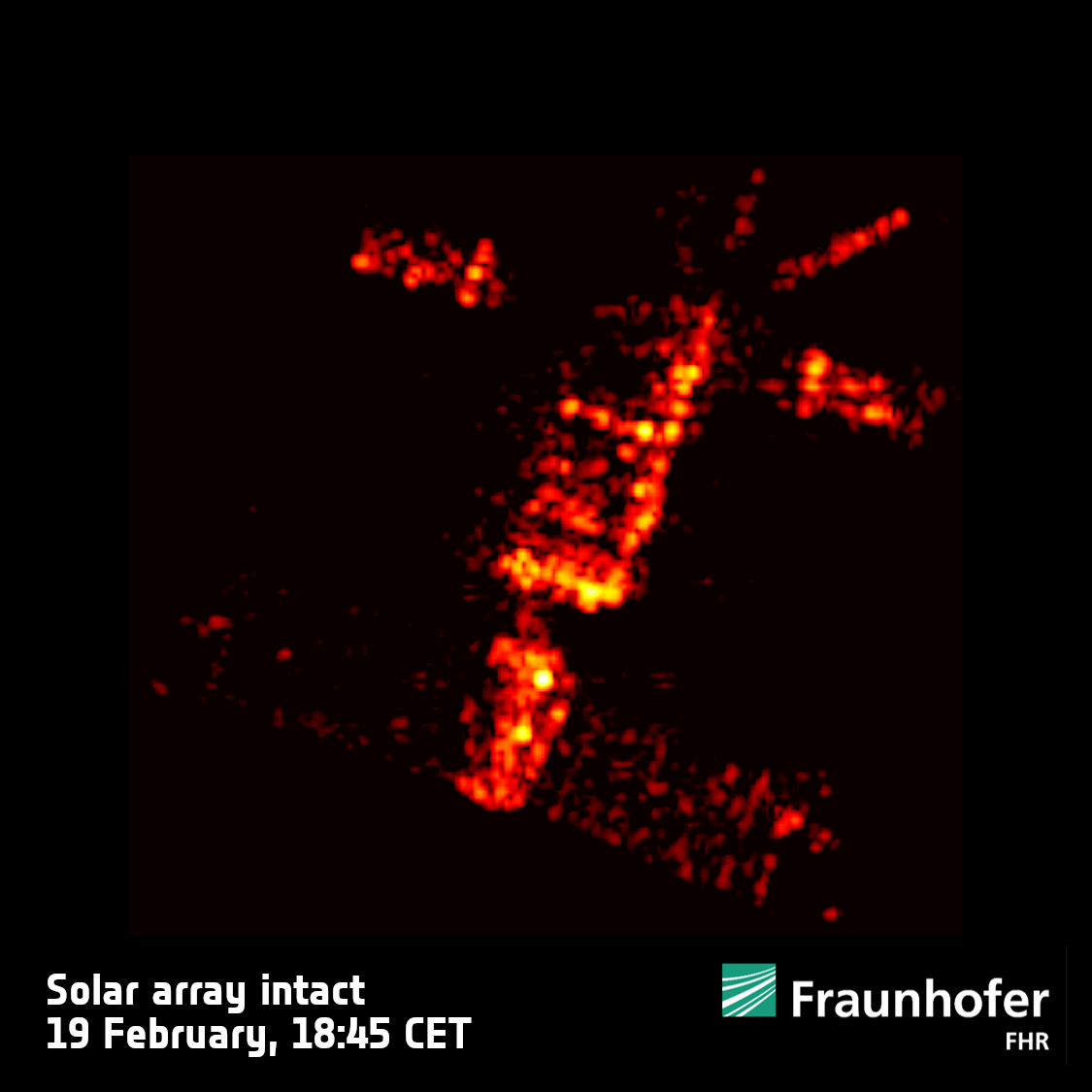 Image:
ERS-2 buckles and bends during final farewell
Image:
ERS-2 buckles and bends during final farewell
ESA satellite returns to Earth – ERS-2 reentry
23.2.2024 13:46 Video:
00:03:29
Video:
00:03:29
Mission complete. ESA’s second European Remote Sensing (ERS-2) satellite has reentered Earth’s atmosphere over the North Pacific Ocean. The satellite returned at 18:17 CET (17:17 UTC) between Alaska and Hawaii.
ERS-2 was launched almost 30 years ago, on 21 April 1995. Together with ERS-1, it provided invaluable long-term data on Earth’s land surfaces, ocean temperatures, ozone layer and polar ice extent that revolutionised our understanding of the Earth system.
ERS-2’s reentry was ‘natural’. ESA used the last of its fuel, emptied its batteries and lowered the satellite from its altitude of 785 km to 573 km. This reduced the risk of collision with other satellites and space debris. As a result, it was not possible to control ERS-2 at any point during its reentry and the only force driving its descent was unpredictable atmospheric drag.
As well as leaving a remarkable legacy of data that still continue to advance science, this outstanding mission set the stage for many of today’s satellites and ESA’s position at the forefront of Earth observation.
The ERS-2 reentry is part of ESA's wider efforts to ensure the long-term sustainability of space activities. These include ESA's Clean Space initiative which promotes the development of new technologies for more sustainable space missions in collaboration with the wider European space community, as well as the Zero Debris Approach, which will even further reduce the debris left in both Earth and lunar orbits by future missions.
Earth from Space: A veil of haze and smoke
23.2.2024 10:00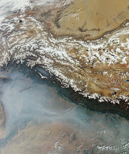 Image:
This Copernicus Sentinel-3 image from October 2023 captures the plains of northern India and Pakistan under a white veil of haze and smoke.
Image:
This Copernicus Sentinel-3 image from October 2023 captures the plains of northern India and Pakistan under a white veil of haze and smoke.
New mission to track changes in the cryosphere
22.2.2024 16:00 Video:
00:15:00
Video:
00:15:00
Tracking ice lost from the world’s glaciers, ice sheets and frozen land shows that Earth is losing ice at an accelerating rate. Monitoring the cryosphere is crucial for assessing, predicting and adapting to climate change.
The Copernicus Polar Ice and Snow Topography Altimeter (CRISTAL) mission will provide a full picture of the changes taking place in some of the most inhospitable regions of the world. It will carry – for the first time – a dual-frequency radar altimeter, and microwave radiometer, that will measure and monitor sea-ice thickness, overlying snow depth and ice-sheet elevations.
These data will support maritime operations in the polar oceans and contribute to a better understanding of climate processes. CRISTAL will also support applications related to coastal and inland waters, as well as providing observations of ocean topography.
CRISTAL is one of six Copernicus Sentinel Expansion missions that ESA is developing on behalf of the EU. The missions will expand the current capabilities of the Copernicus Space Component – the world’s biggest supplier of Earth observation data.
This video features interviews with Kristof Gantois, CRISTAL Project Manager and Paolo Cipollini, CRISTAL Mission Scientist.
New mission to track changes in the cryosphere
22.2.2024 16:00
Video:
00:15:00
Tracking ice lost from the world’s glaciers, ice sheets and frozen land shows that Earth is losing ice at an accelerating rate. Monitoring the cryosphere is crucial for assessing, predicting and adapting to climate change.
The Copernicus Polar Ice and Snow Topography Altimeter (CRISTAL) mission will provide a full picture of the changes taking place in some of the most inhospitable regions of the world. It will carry – for the first time – a dual-frequency radar altimeter, and microwave radiometer, that will measure and monitor sea-ice thickness, overlying snow depth and ice-sheet elevations.
These data will support maritime operations in the polar oceans and contribute to a better understanding of climate processes. CRISTAL will also support applications related to coastal and inland waters, as well as providing observations of ocean topography.
CRISTAL is one of six Copernicus Sentinel Expansion missions that ESA is developing on behalf of the EU. The missions will expand the current capabilities of the Copernicus Space Component – the world’s biggest supplier of Earth observation data.
This video features interviews with Kristof Gantois, CRISTAL Project Manager and Paolo Cipollini, CRISTAL Mission Scientist.
Access all "Unpacking Sentinels" videos.
Satellites increasingly critical to monitor ocean health
22.2.2024 11:45
Playing a huge role in moderating the climate, oceans are fundamental to the functioning of our planet. Understanding more about how seawater temperatures are rising and how oceans are absorbing excess atmospheric carbon dioxide, as well as knock-on issues such as ocean acidification, is key for understanding climate change and for taking effective action.
A recent scientific paper highlights just how satellites are becoming increasingly important in providing unique information on ocean health to guide climate mitigation and adaptation efforts.


NanoMagSat and Tango Scout missions get go-ahead
21.2.2024 8:00
Further embracing the New Space era, ESA is to develop two new Scout satellites: NanoMagSat and Tango. NanoMagSat will measure Earth’s magnetic field to help assess space weather hazards and continue on from ESA’s current Swarm mission. Tango will measure greenhouse-gas emissions from human activity and complements the upcoming Copernicus Carbon Dioxide Monitoring mission and the Sentinel-5 mission, as well as the current Sentinel-5P mission.
Tobago oil spill
16.2.2024 13:28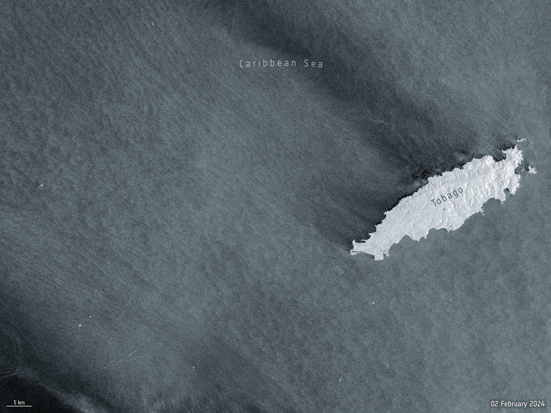 Image:
Before and after satellite images from the Copernicus Sentinel-1 mission show the scale of the oil spill that occurred off the shores of Trinidad and Tobago’s coastline earlier this week.
Image:
Before and after satellite images from the Copernicus Sentinel-1 mission show the scale of the oil spill that occurred off the shores of Trinidad and Tobago’s coastline earlier this week.
Earth from Space: Côte d'Ivoire
16.2.2024 10:00 Image:
The Copernicus Sentinel-2 mission takes us over Côte d'Ivoire in western Africa.
Image:
The Copernicus Sentinel-2 mission takes us over Côte d'Ivoire in western Africa.
What does a warming Arctic mean for the future?
15.2.2024 16:00 Video:
00:12:27
Video:
00:12:27
The Arctic is experiencing disproportionately higher temperature increases compared to the rest of the planet, triggering a series of cascading effects. This rapid warming has profound implications for global climate patterns, human populations and wildlife.
The Copernicus Imaging Microwave Radiometer mission (CIMR) will provide measurements to decision makers with evidence of change and impact in the polar regions – with a focus on the Arctic.
The mission has the largest radiometer developed by ESA and will provide high-resolution measurements related to sea ice, the ocean, snow and ice-sheet surfaces. This will be crucial in understanding the evolution of the climate in the polar region.
CIMR is one of six Copernicus Sentinel Expansion missions that ESA is developing on behalf of the EU. The missions will expand the current capabilities of the Copernicus Space Component – the world’s biggest supplier of Earth observation data.
This video features interviews with Craig Donlon, CIMR Mission Scientist, Rolv Midthassel, CIMR Payload Manager, Claudio Galeazzi, CIMR Project Manager, Mariel Triggianese, CIMR Satellite Engineering and AIV Manager, and Marcello Sallusti, CIMR System Performance and Operations Manager.
In the meantime Craig has changed his role but will retain his position as Mission Scientist.
What does a warming Arctic mean for the future?
15.2.2024 16:00
Video:
00:12:27
The Arctic is experiencing disproportionately higher temperature increases compared to the rest of the planet, triggering a series of cascading effects. This rapid warming has profound implications for global climate patterns, human populations and wildlife.
The Copernicus Imaging Microwave Radiometer mission (CIMR) will provide measurements to decision makers with evidence of change and impact in the polar regions – with a focus on the Arctic.
The mission has the largest radiometer developed by ESA and will provide high-resolution measurements related to sea ice, the ocean, snow and ice-sheet surfaces. This will be crucial in understanding the evolution of the climate in the polar region.
CIMR is one of six Copernicus Sentinel Expansion missions that ESA is developing on behalf of the EU. The missions will expand the current capabilities of the Copernicus Space Component – the world’s biggest supplier of Earth observation data.
This video features interviews with Craig Donlon, CIMR Mission Scientist, Rolv Midthassel, CIMR Payload Manager, Claudio Galeazzi, CIMR Project Manager, Mariel Triggianese, CIMR Satellite Engineering and AIV Manager, and Marcello Sallusti, CIMR System Performance and Operations Manager.
In the meantime Craig has changed his role but will retain his position as Mission Scientist.
Access all "Unpacking Sentinels" videos.
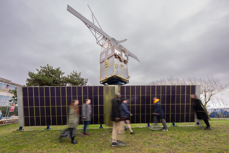 Image:
Saying goodbye to ERS-2
Image:
Saying goodbye to ERS-2
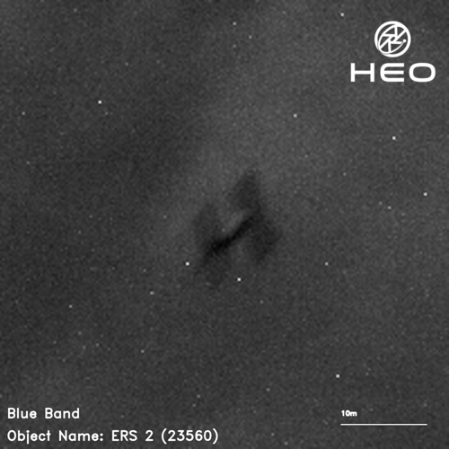
ERS-2 reentry – how and why is it happening?
15.2.2024 9:30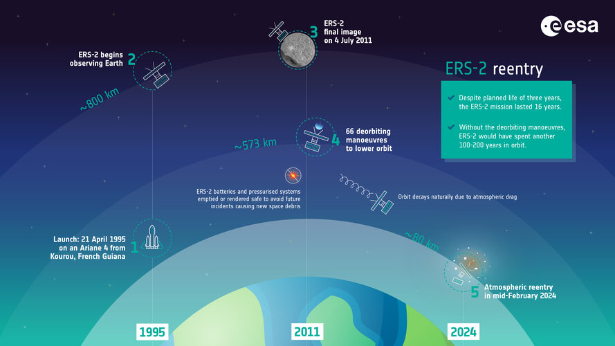 Image:
ERS-2 reentry – how and why is it happening?
Image:
ERS-2 reentry – how and why is it happening?
Air pollution fluctuations over the Po Valley
13.2.2024 15:49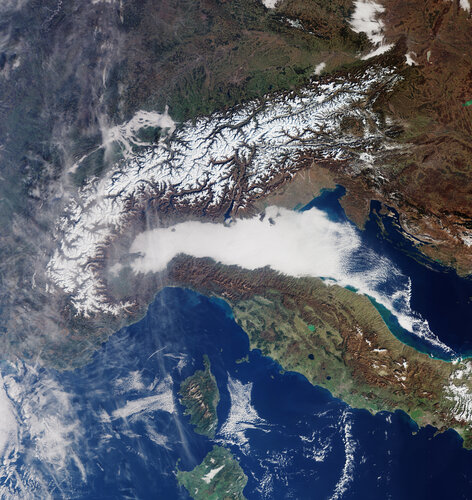
The Po Valley, nestled in northern Italy, is renowned for its picturesque landscapes and rich agricultural history. However, the region is also grappling with a persistent environmental challenge: air pollution. The unique geographical and meteorological conditions of the Po Valley contribute to fluctuations in air quality – impacting the health of its residents.
Earth from Space: South Atlantic bloom
9.2.2024 10:00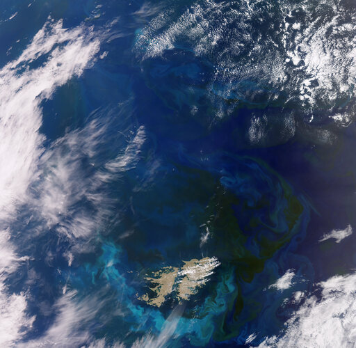 Image:
This wide view from the Copernicus Sentinel-3 mission captures an algae bloom around the Falkland Islands in the South Atlantic Ocean.
Image:
This wide view from the Copernicus Sentinel-3 mission captures an algae bloom around the Falkland Islands in the South Atlantic Ocean.
Heritage ERS-2 satellite to reenter Earth’s atmosphere
5.2.2024 12:00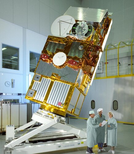
Throughout its 16-year working life, the second European Remote Sensing satellite, ERS-2, returned a wealth of information that revolutionised our perspective of our planet and understanding of climate change. As well as leaving a remarkable legacy of data that still continue to advance science, this outstanding mission set the stage for many of today’s satellites and ESA’s position at the forefront of Earth observation.
In 2011, ESA retired ERS-2 and began the process of deorbiting – and now it’s time for this pioneering satellite to reenter the atmosphere naturally and start to burn up.
Earth from Space: Dubai
2.2.2024 10:00 Image:
This false-colour image acquired by the Copernicus Sentinel-2 mission shows the city of Dubai and its surroundings in the United Arab Emirates.
Image:
This false-colour image acquired by the Copernicus Sentinel-2 mission shows the city of Dubai and its surroundings in the United Arab Emirates.
ESA’s cloud mission in the limelight
1.2.2024 11:00
Dedicated to delivering a wealth of new information on exactly how clouds and aerosols affect Earth’s climate, ESA’s EarthCARE satellite has had the chance to show off prior to engineers embarking upon the careful task of packing it up for its journey to the launch site in the US.
Earth from Space: Snow-bound eastern US
26.1.2024 10:00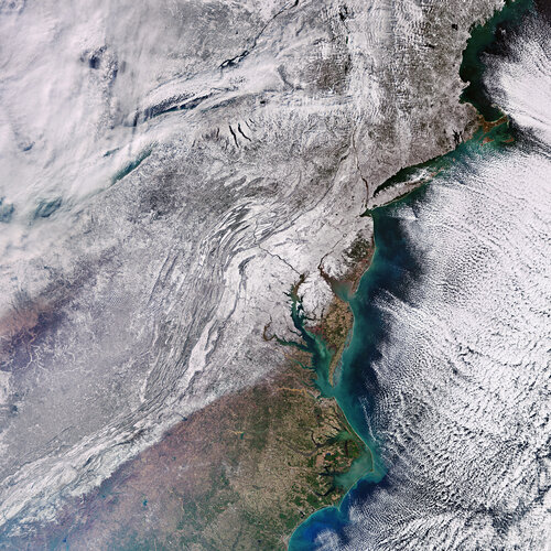 Image:
Record-breaking Arctic cold weather has swept through much of the United States in the last few weeks. The eastern part of the country was particularly affected with thick snow blanketing most of the region, as this Copernicus Sentinel-3 image shows.
Image:
Record-breaking Arctic cold weather has swept through much of the United States in the last few weeks. The eastern part of the country was particularly affected with thick snow blanketing most of the region, as this Copernicus Sentinel-3 image shows.
World’s largest iceberg drifts beyond Antarctic waters
25.1.2024 14:50 Video:
00:00:20
Video:
00:00:20
In November 2023, the A23a mega iceberg set sail after being grounded on the ocean floor for well over 40 years. Now, driven by winds and currents, A23a is heading away from Antarctic waters as seen in this new animation.
The iceberg calved from West Antarctica in 1986 but quickly grounded itself in the Weddell Sea where it remained for over four decades. At around 4000 sq km in area, more than four times the size of New York City, and just over 280 m thick, the berg currently holds the title for world’s largest iceberg.
The animation uses sea-ice concentration data and shows the iceberg’s movements between 1 November 2023 to 23 January 2024. Similar to many icebergs originating from the Weddell sector, A23a is likely to be expelled into the Antarctic Circumpolar Current – propelling it towards the South Atlantic along a trajectory commonly referred to as ‘iceberg alley’.
Sentinel-1 and AI reveal 75% of fishing vessels not tracked
24.1.2024 9:00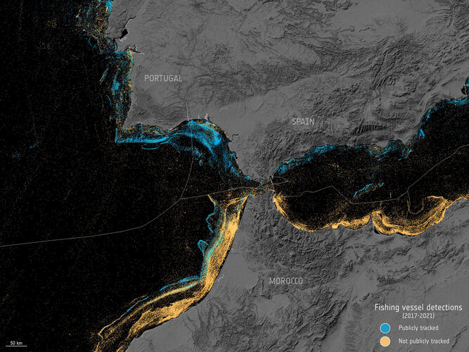
A groundbreaking study that combines satellite data and Artificial Intelligence has thrown new light on the number of vessels at sea. Astonishingly, the study reveals that around 75% of the world's industrial fishing vessels have previously been ‘dark’ to public tracking systems.
Earth from Space: Columbia Glacier, Alaska
19.1.2024 10:00 Image:
The Copernicus Sentinel-2 mission takes us over Alaska’s Columbia Glacier, one of the fastest changing glaciers in the world.
Image:
The Copernicus Sentinel-2 mission takes us over Alaska’s Columbia Glacier, one of the fastest changing glaciers in the world.
Media invitation: Last chance to see the EarthCARE satellite
12.1.2024 10:36
Media invitation: Last chance to see the EarthCARE satellite
Top 10 Earth observation stories of 2023
20.12.2023 11:50
This year has been a whirlwind of captivating Earth observation stories and news, spanning from dramatic volcanic eruptions to powerful earthquakes to witnessing icebergs on the run. Join us as we revisit some of the most memorable stories from 2023.
Earth from Space: Icy landscape
15.12.2023 10:00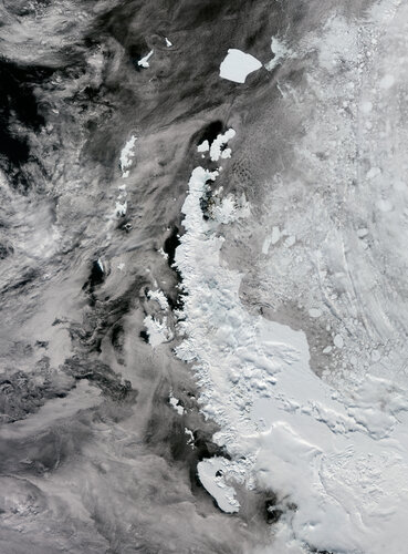 Image:
As the holiday season swiftly approaches, frosty landscapes tend to be associated with the magical idea of a white Christmas. But this Copernicus Sentinel-3 image over the Antarctic Peninsula sheds light on a different perspective.
Image:
As the holiday season swiftly approaches, frosty landscapes tend to be associated with the magical idea of a white Christmas. But this Copernicus Sentinel-3 image over the Antarctic Peninsula sheds light on a different perspective.
Earth from Space: Icy landscape
15.12.2023 10:00
Image:
As the holiday season swiftly approaches, frosty landscapes tend to be associated with the magical idea of a white Christmas. But this Copernicus Sentinel-3 image over the Antarctica Peninsula sheds light on a different perspective.
ESA forges ahead with Destination Earth
14.12.2023 14:00
The second phase of the European Union’s Destination Earth initiative has been approved at ESA Council. Destination Earth, also known as DestinE, will build digital models of Earth allowing greater insight into weather and climate dynamics and their impacts on society.
Permafrost thaw: a silent menace
12.12.2023 12:00 Video:
00:05:47
Video:
00:05:47
Ice is without doubt one of the first casualties of climate change, but the effects of our warming world are not only limited to ice melting on Earth’s surface. Ground that has been frozen for thousands of years, called permafrost, is thawing – adding to the climate crisis and causing serious issues for local communities.
Scientists estimate that the world’s permafrost holds almost double the amount of carbon that is currently in the atmosphere. When permafrost warms and thaws, it releases methane and carbon dioxide, adding these greenhouse gases to the atmosphere and making global warming even worse.
While permafrost cannot be directly observed from space, a lot of different types of satellite data, along with ground measurements and modelling, allow scientists to paint a picture of permafrost ground conditions.
Little Pictures winner announced at COP28
11.12.2023 14:35
The winning entry to a Europe-wide data visualisation contest was announced and showcased last week at COP28. The ‘Little Pictures’ competition challenged the continent’s creative talent to design compelling illustrations using the range of global observation records available from ESA, the European Organisation for the Exploitation of Meteorological Satellites (Eumetsat) and European Centre for Medium-Range Weather Forecasts (ECMWF), to highlight the key changes taking place across the climate.
Earth from Space: Hurricane Otis
8.12.2023 10:00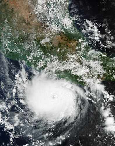 Image:
The powerful Hurricane Otis has been captured in this Copernicus Sentinel-3 image when it was approaching Mexico’s southern Pacific coast in October 2023.
Image:
The powerful Hurricane Otis has been captured in this Copernicus Sentinel-3 image when it was approaching Mexico’s southern Pacific coast in October 2023.
Minding the gap on tropical forest carbon
7.12.2023 9:00
Tropical forests are clearly critical to Earth’s climate system, but understanding exactly how much carbon they absorb from the atmosphere, store and release is tricky to calculate, not least because measuring and reporting methods vary. With these measurements paramount for nations assessing the action they are taking to combat the climate crisis, new research shows how differences in estimates of carbon flux associated with human activity can be reconciled.
Tracking human emissions from space
6.12.2023 16:00The Copernicus Anthropogenic Carbon Dioxide Monitoring (CO2M) mission will be the first satellite mission to measure how much carbon dioxide is released into the atmosphere through human activity.
CO2M isn't just a mission; it's a crucial step in our commitment to understanding and mitigating climate change. It will offer unprecedented precision in monitoring carbon dioxide emissions from the combustion of fossil fuel at national and regional scales.
Its data will provide the EU with a unique and independent source of information to assess the effectiveness of policy measures and to track their impact towards decarbonising Europe ahead of the next Global Stocktake set to place in 2028.
The video features interviews with Valerie Fernandez, CO2M Mission Project Manager, Yannig Durand, CO2M Payload Manager and Yasjka Meijer, CO2M Mission Scientist.
Tracking human emissions from space
6.12.2023 16:00The Copernicus Anthropogenic Carbon Dioxide Monitoring (CO2M) mission will be the first satellite mission to measure how much carbon dioxide is released into the atmosphere through human activity.
CO2M isn't just a mission; it's a crucial step in our commitment to understanding and mitigating climate change. It will offer unprecedented precision in monitoring carbon dioxide emissions from the combustion of fossil fuel at national and regional scales.
Its data will provide the EU with a unique and independent source of information to assess the effectiveness of policy measures and to track their impact towards decarbonising Europe ahead of the next Global Stocktake set to place in 2028.
CO2M is one of six Copernicus Sentinel Expansion missions that ESA is developing on behalf of the EU. The missions will expand the current capabilities of the Copernicus Space Component – the world’s biggest supplier of Earth observation data.
The video features interviews with Valerie Fernandez, CO2M Mission Project Manager, Yannig Durand, CO2M Payload Manager and Yasjka Meijer, CO2M Mission Scientist.
Understanding climate tipping points
6.12.2023 14:30
As the planet warms, many parts of the Earth system are undergoing large-scale changes. Ice sheets are shrinking, sea levels are rising and coral reefs are dying off.
While climate records are being continuously broken, the cumulative impact of these changes could also cause fundamental parts of the Earth system to change dramatically. These ‘tipping points’ of climate change are critical thresholds in that, if exceeded, can lead to irreversible consequences.
Delve into the new CEOS Earth Observation Handbook
5.12.2023 10:15
Delve into the new CEOS Earth Observation Handbook
ESA and UNEP collaborate for a greener future
4.12.2023 11:56
In a significant step towards a more sustainable future, ESA and the United Nations Environment Programme (UNEP) have signed a Memorandum of Understanding during Earth Information Day at COP28 currently taking place in Dubai.
The memorandum signifies a commitment to harness the power of space technology and data for environmental conservation, nature and biodiversity protection and restoration.
Contract secures next step for TRUTHS climate mission
4.12.2023 11:00
Delegates from around 200 countries are convened at the United Nations COP28 summit in Dubai to assess the action they are taking to combat the climate crisis. With satellites fundamental to understanding and monitoring climate change, ESA has awarded a contract to Airbus to take the TRUTHS satellite mission to its next development phase.
TRUTHS is set to provide the gold reference for climate measurements, thereby giving decision-makers more confidence in the data they use for climate action.
Earth from Space: American Samoa
1.12.2023 11:40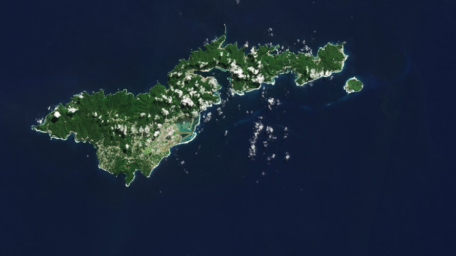 Image:
The Copernicus Sentinel-2 mission shows us an amazing view of the tropical island of Tutuila, the largest in the American Samoa archipelago in the South Pacific Ocean.
Image:
The Copernicus Sentinel-2 mission shows us an amazing view of the tropical island of Tutuila, the largest in the American Samoa archipelago in the South Pacific Ocean.
Iceberg on the loose
1.12.2023 9:00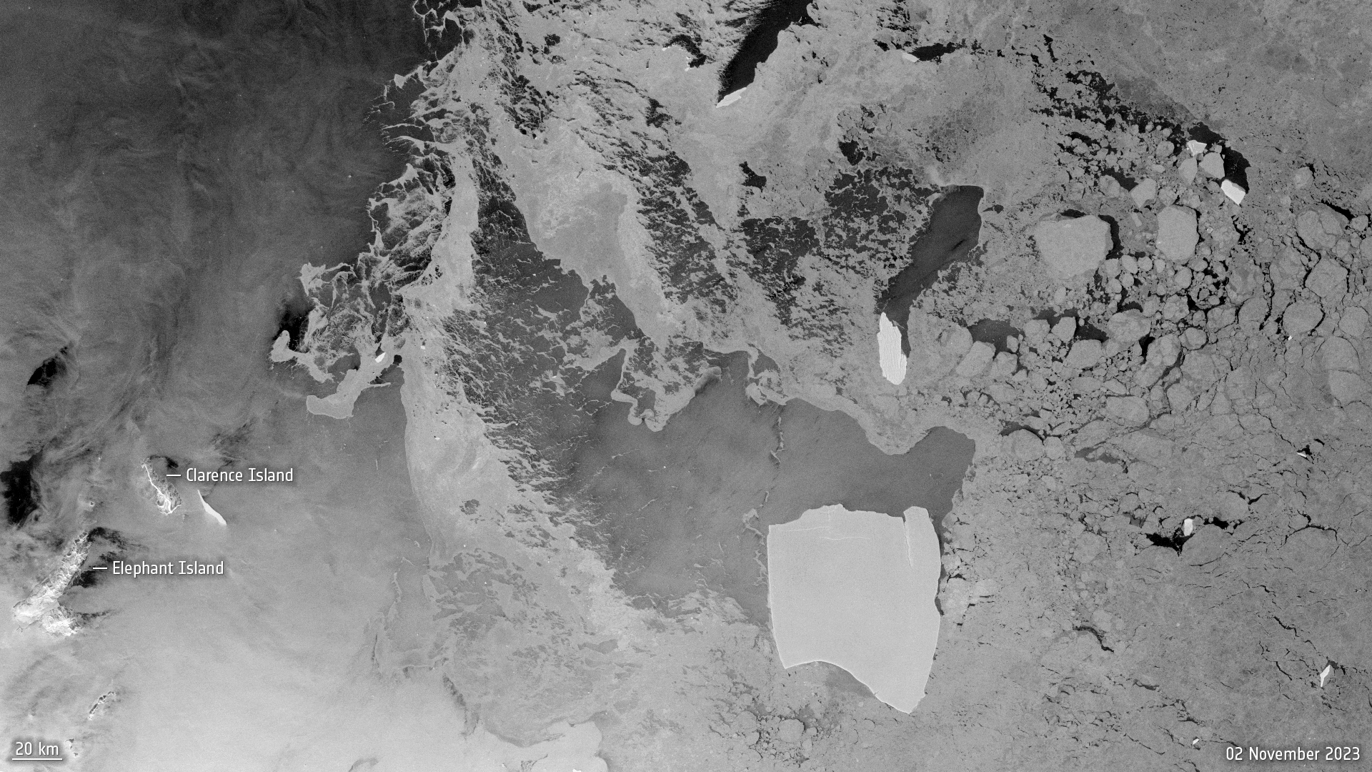 Image:
After being grounded on the ocean floor for well over four decades, the largest iceberg in the world is on the loose.
Image:
After being grounded on the ocean floor for well over four decades, the largest iceberg in the world is on the loose.
Global Stocktake: how space drives climate action
30.11.2023 17:30 Video:
00:12:34
Video:
00:12:34
Almost 200 countries are gathering in Dubai to attend the biggest climate event of the year. COP28 – the 2023 United Nations climate change summit – isn’t just another conference though. For the first time, country representatives will assess the progress they’ve made towards cutting their greenhouse gas emissions through a process called the ‘global stocktake’.
Satellites are critical in the quest to tackle climate change as they give the robustness and transparency needed to monitor progress towards a lower-emissions and more resilient world. If undertaken effectively, the global stocktake can provide an opportunity to leverage decisions and accelerate ambition in climate action plans.
This video contains interviews with ESA Director of Earth Observation Programmes, Simonetta Cheli, Antony Delavois, ESA Junior Professional, Atmospheric Composition and Yasjka Meijer, CO2M Mission Scientist.
Taking climate action with Earth observation
30.11.2023 10:10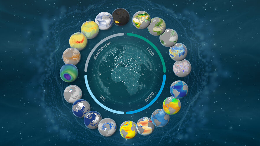
As global temperatures records are smashed and greenhouse gas emissions reach new highs, a new report from the UN Environment Programme finds that current pledges under the Paris Agreement put the world on track for a 2.5–2.9°C temperature rise this century – pointing to the urgent need for increased climate action.
The report is timely as nearly 200 nations gather in the coming two weeks at the United Nations COP28 Climate Change Summit to conclude the world’s first ever ‘Global Stocktake’ on climate change. Swift and sustained climate action is needed to avoid the worst consequences of climate change. Satellites are critical tools in the quest to tackle climate change and monitor progress towards a lower-emissions and more resilient world.
How will EarthCARE shed light on clouds?
29.11.2023 14:18
In around six months, ESA’s Earth Cloud Aerosol and Radiation Explorer mission will take to the skies to advance our understanding of the interactions between clouds, aerosols and radiation in Earth’s atmosphere. But how will it do that exactly?
The power of Earth observation
29.11.2023 10:00 Video:
00:02:07
Video:
00:02:07
We are all intricately interconnected to our Earth – from the trees that provide us with oxygen, to the natural sources that shape our landscape. ESA's Earth observation programme is at the forefront of monitoring our planet's dynamic changes. Using cutting-edge satellite technology, ESA captures invaluable data on Earth's atmosphere, land and oceans. From tracking climate patterns to assessing environmental health, ESA's Earth observation initiatives provide essential insights for scientific research, environmental management and disaster response. By harnessing space technology, ESA contributes significantly to our understanding of Earth – ensuring a sustainable future for generations to come.
Warming ocean causing rapid glacier retreat
28.11.2023 17:00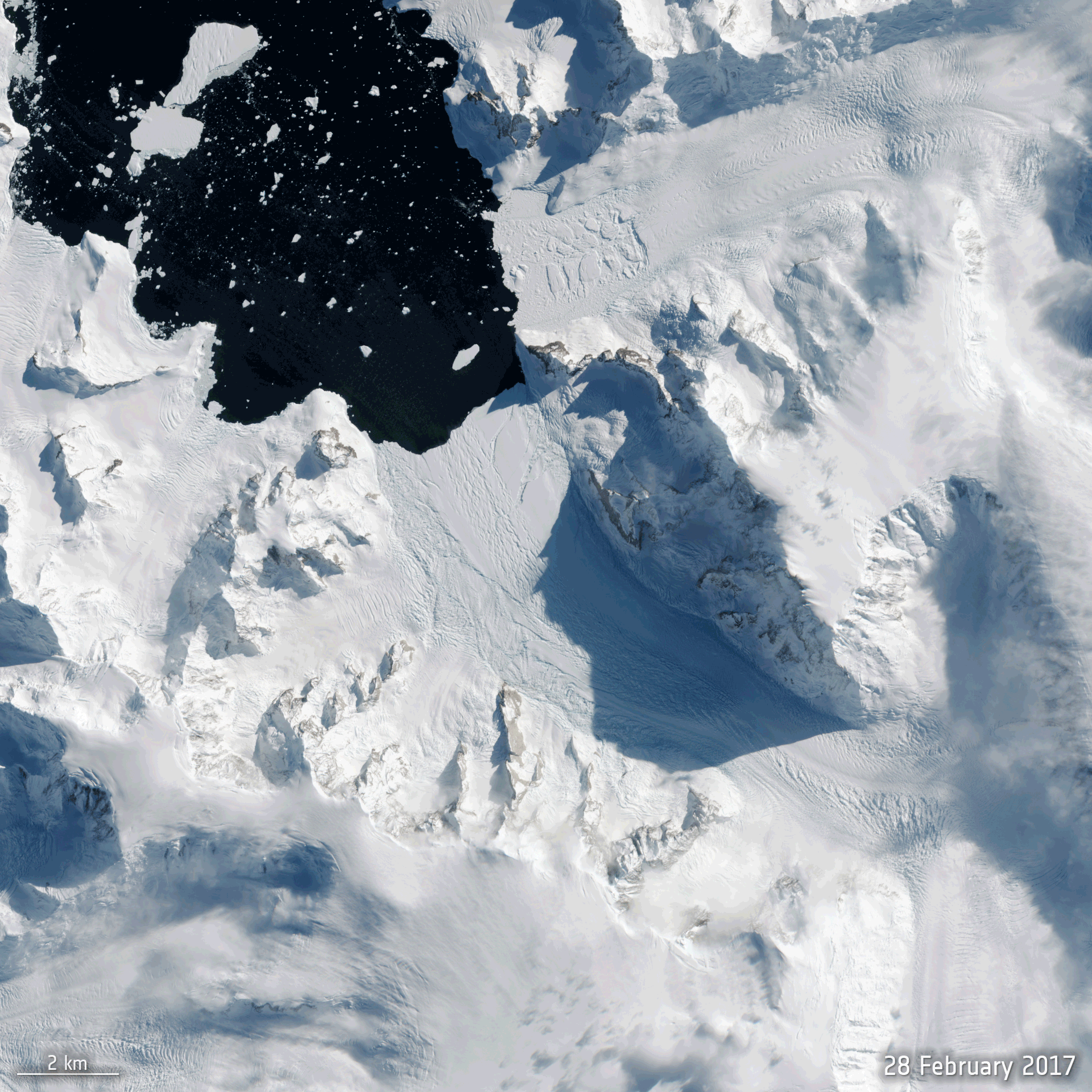
With all eyes about to focus on the COP28 climate conference in Dubai, new scientific findings show, again, that the climate crisis is taking its toll on Antarctica – a continent, up to recently, thought better able to withstand the immediate effects of rising global temperatures.
Using satellite data, scientists have discovered that the ice shelf extending into the ocean from Cadman Glacier on the west Antarctic Peninsula collapsed, leaving the glacier exposed to unusually warm ocean water, which caused the glacier to accelerate and retreat rapidly.
Earth from Space: Salty lakes
24.11.2023 10:00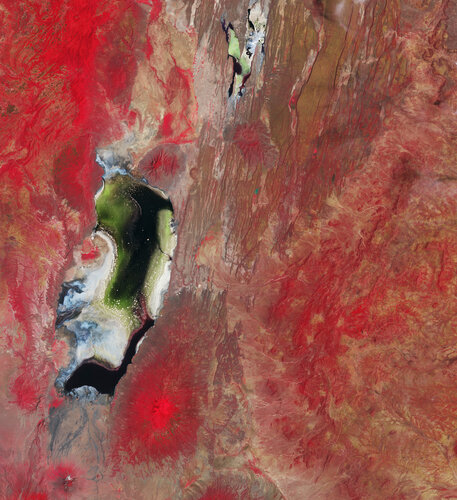 Image:
The Copernicus Sentinel-2 mission captures the colourful waters of two salty lakes in East Africa: Lake Natron in northern Tanzania and Lake Magadi in southern Kenya.
Image:
The Copernicus Sentinel-2 mission captures the colourful waters of two salty lakes in East Africa: Lake Natron in northern Tanzania and Lake Magadi in southern Kenya.
Spire joins ESA's Third Party Mission Programme
23.11.2023 11:54
Spire joins ESA's Third Party Mission Programme
Cairt and Wivern Earth Explorer candidates go forward
21.11.2023 12:52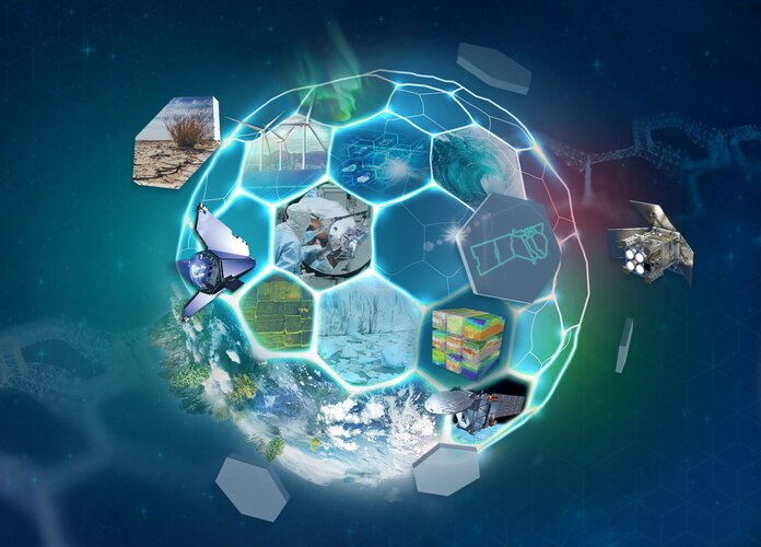
ESA has reached a significant milestone in its commitment towards a deeper understanding of Earth's dynamic processes and addressing pressing environmental challenges with the selection of two new candidates – Cairt and Wivern – to progress to the next development phase as part of the process of realising the Agency’s eleventh Earth Explorer satellite mission.
Arctic Weather Satellite in shape
20.11.2023 15:44
Embracing the New Space approach, it has taken just 36 months to develop and build ESA’s Arctic Weather Satellite. Now complete, this remarkable microsatellite has been shipped from OHB in Sweden to Germany where it is starting a series of tests to make sure that it will survive liftoff next year and its subsequent life in orbit.
Earth from Space: North Channel
17.11.2023 10:00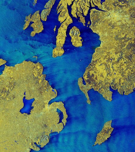 Image:
The North Channel, between Northern Ireland and Scotland, is featured in this false-colour radar image from the Copernicus Sentinel-1 mission.
Image:
The North Channel, between Northern Ireland and Scotland, is featured in this false-colour radar image from the Copernicus Sentinel-1 mission.
Italy's Mount Etna spews lava
15.11.2023 15:00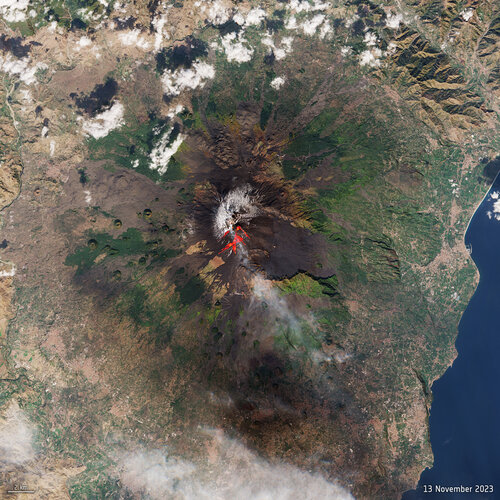 Image:
One of the world’s most active volcanoes, Mount Etna, erupted on Sunday – spewing lava and clouds of ash high over the Mediterranean island of Sicily. This image, captured on 13 November by the Copernicus Sentinel-2 mission, has been processed using the mission’s shortwave-infrared bands to show the lava flow at the time of acquisition.
Image:
One of the world’s most active volcanoes, Mount Etna, erupted on Sunday – spewing lava and clouds of ash high over the Mediterranean island of Sicily. This image, captured on 13 November by the Copernicus Sentinel-2 mission, has been processed using the mission’s shortwave-infrared bands to show the lava flow at the time of acquisition.
MetOp Second Generation weather satellite pair show off
15.11.2023 10:57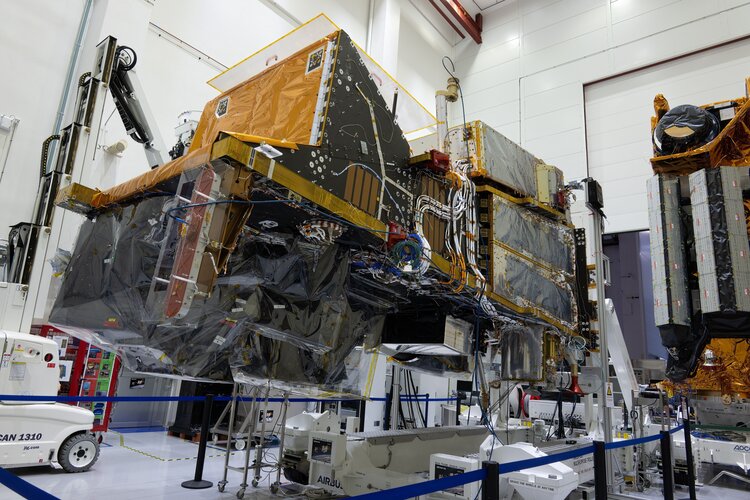
Having satellites in different types of orbit is essential to delivering data to forecast the weather accurately. With the first Meteosat Third Generation Imager satellite safely in geostationary orbit since December 2022, it’s also time to focus on its polar-orbiting cousin, the MetOp Second Generation mission. And now, for the first time, two MetOp Second Generation satellites have been brought together to stand side-by-side for testing.
Monitoring methane emissions from space
13.11.2023 13:00 Video:
00:03:23
Video:
00:03:23
Methane is the second most important greenhouse gas contributor to climate change after carbon dioxide. Curbing methane emissions could deliver immediate and long-lasting benefits for the climate, seeing as the gas only lingers in the atmosphere for a relatively short time.
Satellites have a really important role to play in reducing greenhouse gas emissions. The Tropomi instrument onboard the Copernicus Sentinel-5P satellite is the only instrument that maps global methane concentrations every single day. This lets scientists detect hotspots for large methane sources around the world – allowing us to address the consequences of methane emissions on our climate and environment.
Monitoring methane from space
13.11.2023 13:00 Video:
00:03:23
Video:
00:03:23
Methane is the second most important greenhouse gas contributor to climate change after carbon dioxide. Curbing methane emissions could deliver immediate and long-lasting benefits for the climate, seeing as the gas only lingers in the atmosphere for a relatively short time.
Satellites have a really important role to play in reducing greenhouse gas emissions. The Tropomi instrument onboard the Copernicus Sentinel-5P satellite is the only instrument that maps global methane concentrations every single day. This lets scientists detect hotspots for large methane sources around the world – allowing us to address the consequences of methane emissions on our climate and environment.
Two ESA Φ-lab-enabled satellites launched
13.11.2023 10:15
MANTIS, the first satellite mission to be supported from concept to liftoff by ESA’s Earth Observation InCubed programme, was launched yesterday on a SpaceX Falcon 9 rocket. MANTIS carries a high-resolution multispectral camera coupled with a powerful AI processing unit.
Intuition-1 was also launched on the same rocket and will similarly demonstrate the advantages of onboard AI capabilities, in this case in tandem with a hyperspectral imager. The satellite’s machine learning algorithms were developed under the ESA-funded Genesis project.
Two ESA Φ-lab-enabled satellites launched
13.11.2023 10:15
MANTIS, the first satellite mission to be supported from concept to liftoff by ESA’s Earth Observation InCubed programme, was launched yesterday on a SpaceX Falcon 9 rocket. MANTIS carries a high-resolution multispectral camera coupled with a powerful AI processing unit.
Intuition-1 was also launched on the same rocket and will similarly demonstrate the advantages of onboard AI capabilities, in this case in tandem with a hyperspectral imager. The satellite’s machine learning algorithms were developed under the ESA-funded Genesis project
Two ESA Φ-lab-enabled satellites launched
13.11.2023 10:15
MANTIS, the first satellite mission to be supported from concept to liftoff by ESA’s Earth Observation InCubed programme, has been launched on a SpaceX Falcon 9 rocket. MANTIS carries a high-resolution multispectral camera coupled with a powerful AI processing unit.
Intuition-1 was also launched on the same rocket and will similarly demonstrate the advantages of onboard AI capabilities, in this case in tandem with a hyperspectral imager. The satellite’s machine learning algorithms were developed under the ESA-funded Genesis project
Nourishing commercial growth in Earth observation
10.11.2023 13:17
Hot on the heels of the first Earth Observation Commercialisation Forum, now is a good time to take a look at the all-embracing support that ESA gives to the commercial sector in Europe. With funding programmes, business guidance for companies, and multiyear contracts, ESA provides a vital springboard for continued growth in commercial Earth observation.
Earth from Space: Autumn in Japan
10.11.2023 10:00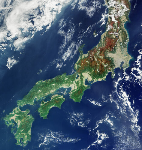 Image:
This image, from the Copernicus Sentinel-3 mission on 1 November 2023, captures the colours of autumn over the Japanese archipelago.
Image:
This image, from the Copernicus Sentinel-3 mission on 1 November 2023, captures the colours of autumn over the Japanese archipelago.
AI maps icebergs 10,000 times faster than humans
9.11.2023 9:00
In a groundbreaking development, researchers from the University of Leeds have unveiled a neural network that can swiftly and accurately chart the expanse of large Antarctic icebergs in satellite images, accomplishing the task in a mere 0.01 seconds. This novel approach is in stark contrast to the laborious and time-consuming manual efforts needed previously.
ESA and EC to unite on climate action from space
6.11.2023 12:00
ESA and the European Commission are joining forces to accelerate the use of Earth-observing satellites and the information they provide to address the pressing challenge of climate change.
This landmark initiative signifies a firm commitment to advancing our understanding of Earth's climate system and enhancing our ability to take timely and informed actions to mitigate and adapt to the impacts of climate change, particularly encompassing the European Green Deal.
Earth from Space: Lake Maracaibo
3.11.2023 10:00 Image:
The Copernicus Sentinel-2 mission takes us over Venezuela’s Lake Maracaibo, the largest natural body of water in South America.
Image:
The Copernicus Sentinel-2 mission takes us over Venezuela’s Lake Maracaibo, the largest natural body of water in South America.
Relive the Earth Observation Commercialisation Forum
2.11.2023 13:30
ESA’s first Earth Observation Commercialisation Forum took place at ESA Headquarters in Paris on 30–31 October 2023. The event saw investors, institutions, entrepreneurs and different-sized companies from the Earth observation sector come together to discuss the commercial potential and challenges of Earth observation. Revisit the event by watching the streaming replay.
Spooky sights from space: world’s largest acidic lake
31.10.2023 9:15 Image:
What’s spookier than the ‘largest acid cauldron on Earth?’ In East Java, Indonesia, lies the Kawah Ijen Crater Lake – the world’s largest acidic lake, a chilling spectacle perfect for Halloween.
Image:
What’s spookier than the ‘largest acid cauldron on Earth?’ In East Java, Indonesia, lies the Kawah Ijen Crater Lake – the world’s largest acidic lake, a chilling spectacle perfect for Halloween.
Watch live: ESA’s Earth Observation Commercialisation Forum
27.10.2023 13:45
ESA’s first-ever Earth Observation Commercialisation Forum will take place next week at ESA Headquarters in Paris from 30 to 31 October 2023. The event will see investors, institutions, entrepreneurs and companies of any size from the Earth observation sector coming together to discuss the commercial potential and challenges of Earth observation. Follow our live steaming on ESA WebTV Two.
Earth from Space: Elephant Island
27.10.2023 10:00 Image:
This rare, almost cloud-free view of the remote Elephant Island in Antarctica was captured in February 2023 by the Copernicus Sentinel-2 mission.
Image:
This rare, almost cloud-free view of the remote Elephant Island in Antarctica was captured in February 2023 by the Copernicus Sentinel-2 mission.
Gearing up for EarthCARE
27.10.2023 9:00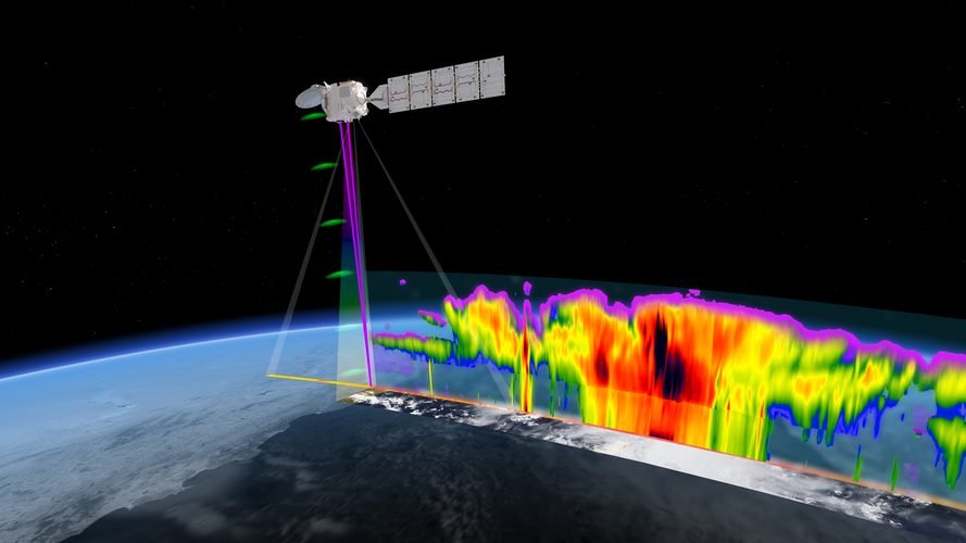
ESA and the Japanese Aerospace Exploration Agency are gearing up for a momentous milestone in Earth observation as launch of the EarthCARE satellite approaches.
Following years of rigorous development and extensive testing, the satellite is now undergoing its final round of tests in Europe before being shipped to the launch site early next year – bringing us one step closer to gaining unprecedented insights into the role that clouds and aerosols play in the climate system.
Six trends to watch in commercial Earth observation
26.10.2023 11:20
With a multitude of opportunities for start-ups, established companies and investors, commercial Earth observation is a vibrant sector with fast-moving innovations in technology, datasets and downstream applications. ESA is a key driving force for the development of European Earth observation and provides impetus through its many programmes and initiatives.
To set the scene ahead of ESA’s Earth Observation Commercialisation Forum next week, here is some need-to-know background information on the evolution and state of play of the Earth observation industry.
Earth from Space: Panama Canal
20.10.2023 10:00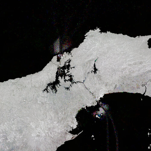 Image:
Like shining jewels in the water, ships passing through the Panama Canal, which cuts across Central America, have been captured in this Copernicus Sentinel-1 image.
Image:
Like shining jewels in the water, ships passing through the Panama Canal, which cuts across Central America, have been captured in this Copernicus Sentinel-1 image.
Copernicus operations resilience: Inuvik wildfires
19.10.2023 15:00
Copernicus operations resilience: Inuvik wildfires
Earth from Space: Bentiu, South Sudan
13.10.2023 10:00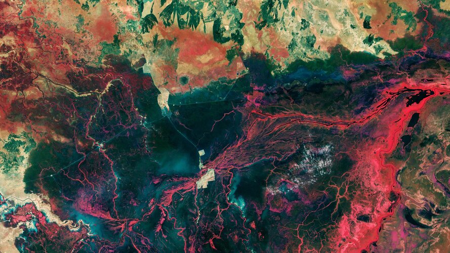 Image:
The landscape around the city of Bentiu in South Sudan is featured in this Copernicus Sentinel-2 image.
Image:
The landscape around the city of Bentiu in South Sudan is featured in this Copernicus Sentinel-2 image.
Antarctic ice shelf demise
13.10.2023 8:30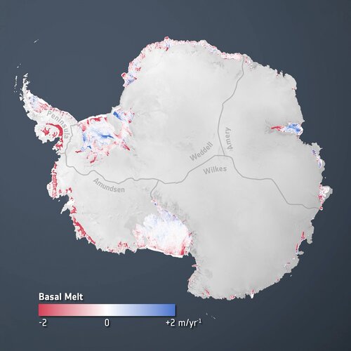
New research, based largely on information from the Copernicus Sentinel-1 and ESA’s CryoSat satellite missions, has revealed alarming findings about the state of Antarctica's ice shelves: 40% of these floating shelves have significantly reduced in volume over the past quarter-century. While this underscores the accelerating impacts of climate change on the world's southernmost continent, the picture of ice deterioration is mixed.
Antarctic ice shelf demise
13.10.2023 8:30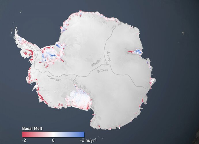
New research, based largely on information from the Copernicus Sentinel-1 and ESA’s CryoSat satellite missions, has revealed alarming findings about the state of Antarctica's ice shelves: 40% of these floating shelves have significantly reduced in volume over the past quarter-century. While this underscores the accelerating impacts of climate change on the world's southernmost continent, the picture of ice deterioration is mixed.
Measuring nutrition in crops from space
10.10.2023 13:59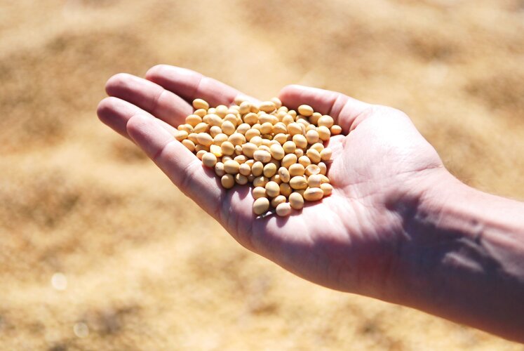
With many people around the world suffering from various forms of malnutrition it’s important that the absolute basics such as rice, soya and wheat are as nourishing as possible. ESA-funded research shows that the Copernicus Sentinel-2 mission and the Italian Prisma mission could be used to monitor the nutritional content of staple crops. This could, for example, help farmers take appropriate steps to boost the quality of their crops as they grow.