


zprávy
zdroje zpráv:Nové letecké snímky v aplikaci Archiv
31.8.2023 8:00 ČÚZK - Geoportál Nové letecké snímky v aplikaci ArchivAplikace Archiv byla doplněna o nově naskenované archivní letecké měřické snímky z let 1974, 1993 a 1994.
Nové letecké snímky v aplikaci Archiv
31.8.2023 8:00 ČÚZK - Geoportál Nové letecké snímky v aplikaci ArchivAplikace Archiv byla doplněna o nově naskenované archivní letecké měřické snímky z let 1974, 1993 a 1994.
Nové letecké snímky v aplikaci Archiv
31.8.2023 8:00 ČÚZK - Geoportál Nové letecké snímky v aplikaci ArchivAplikace Archiv byla doplněna o nově naskenované archivní letecké měřické snímky z let 1974, 1993 a 1994.
Nové letecké snímky v aplikaci Archiv
31.8.2023 8:00 ČÚZK - Geoportál Nové letecké snímky v aplikaci ArchivAplikace Archiv byla doplněna o nově naskenované archivní letecké měřické snímky z let 1974, 1993 a 1994.
Nové letecké snímky v aplikaci Archiv
31.8.2023 8:00 ČÚZK - Geoportál Nové letecké snímky v aplikaci ArchivAplikace Archiv byla doplněna o nově naskenované archivní letecké měřické snímky z let 1974, 1993 a 1994.
Nové letecké snímky v aplikaci Archiv
31.8.2023 8:00 ČÚZK - Geoportál Nové letecké snímky v aplikaci ArchivAplikace Archiv byla doplněna o nově naskenované archivní letecké měřické snímky z let 1974, 1993 a 1994.
Nové letecké snímky v aplikaci Archiv
31.8.2023 8:00 ČÚZK - Geoportál Nové letecké snímky v aplikaci ArchivAplikace Archiv byla doplněna o nově naskenované archivní letecké měřické snímky z let 1974, 1993 a 1994.
Nové letecké snímky v aplikaci Archiv
31.8.2023 8:00 ČÚZK - Geoportál Nové letecké snímky v aplikaci ArchivAplikace Archiv byla doplněna o nově naskenované archivní letecké měřické snímky z let 1974, 1993 a 1994.
Nové letecké snímky v aplikaci Archiv
31.8.2023 8:00 ČÚZK - Geoportál Nové letecké snímky v aplikaci ArchivAplikace Archiv byla doplněna o nově naskenované archivní letecké měřické snímky z let 1974, 1993 a 1994.
Nové letecké snímky v aplikaci Archiv
31.8.2023 8:00 ČÚZK - Geoportál Nové letecké snímky v aplikaci ArchivAplikace Archiv byla doplněna o nově naskenované archivní letecké měřické snímky z let 1974, 1993 a 1994.
Nové letecké snímky v aplikaci Archiv
31.8.2023 8:00 ČÚZK - Geoportál Nové letecké snímky v aplikaci ArchivAplikace Archiv byla doplněna o nově naskenované archivní letecké měřické snímky z let 1974, 1993 a 1994.
Nové letecké snímky v aplikaci Archiv
31.8.2023 8:00 ČÚZK - Geoportál Nové letecké snímky v aplikaci ArchivAplikace Archiv byla doplněna o nově naskenované archivní letecké měřické snímky z let 1974, 1993 a 1994.
20230830 - nový VFR adres
30.8.2023 13:44 ČÚZK /ruian/Poskytovani-udaju-ISUI-RUIAN-VDP/Vymenny-format-RUIAN-(VFR)/Archiv-novinek-VFR/2023/20230830-novy-VFR-adresVýběrové řízení na pozici rada / odborný rada v oddělení právních vztahů k nemovitostem Katastrálníh
30.8.2023 13:19 ČÚZK /Urady/Katastralni-urady/Katastralni-urady/Katastralni-urad-pro-Kralovehradecky-kraj/Uredni-deska/Oznameni-a-jina-uredni-sdeleni/Volna-mista/DMS/rada-odborny-rada-v-oddeleni-pravnich-vztahu-k-nemVýběrové řízení na pozici rada / odborný rada v oddělení právních vztahů k nemovitostem Katastrálníh
30.8.2023 13:19 ČÚZK - volná místa Katastrální úřad pro Královéhradecký kraj vypisuje výběrové řízení na místo Výběrové řízení na pozici rada / odborný rada v oddělení právních vztahů k nemovitostem Katastrálníhrada / odborný rada v oddělení právních vztahů k nemovitostem Katastrálního pracoviště Hradec Králov
30.8.2023 13:19 ČÚZK /Urady/Katastralni-urady/Katastralni-urady/Katastralni-urad-pro-Kralovehradecky-kraj/Uredni-deska/Oznameni-a-jina-uredni-sdeleni/Volna-mista/DMS/rada-odborny-rada-v-oddeleni-pravnich-vztahu-k-nemVýběrové řízení na pozici rada / odborný rada v oddělení právních vztahů k nemovitostem Katastrálníh
30.8.2023 13:19 ČÚZK - předpisy a opatření Katastrální úřad pro Královéhradecký krajvypisuje výběrové řízení na místo
Výběrové řízení na pozici rada / odborný rada v oddělení právních vztahů k nemovitostem Katastrálního pracoviště Hradec Králové
FME User Conference 2023 - po roce opět na "olympiádě datových specialistů"!
30.8.2023 12:37 GIS Fórumrada/odborný rada - inspektor Zeměměřického a katastrálního inspektorátu v Liberci
30.8.2023 9:09 ČÚZK /Urady/Zememericke-a-katastralni-inspektoraty/Zememericke-a-katastralni-inspektoraty/Zememericky-a-katastralni-inspektorat-v-Liberci/Uredni-deska/Oznameni-a-jina-uredni-sdeleni/Volna-mista/DMS/Oznameni-o-vyhlaseni-VRKomáří dotazník
30.8.2023 7:22 Katedra geoinformatiky UP Olomouc 🔹Pomozte nám zmapovat aktivitu komárů v Litovelském Pomoraví a jeho okolí! 🔹Vyplňte unikátní online dotazník, jehož prostřednictvím získáme důležité údaje o aktuálním výskytu komárů. 🔹Data pak budou využity při opatřeních k omezení populace tohoto obtížného hmyzu. 🔹Dotazník je krátký a jeho vyplnění by nemělo zabrat více než pět minut. 🦟 https://www.pocitovemapy.cz/komari-2023/ 🔹DĚKUJEME🔹Komáří dotazník
30.8.2023 7:22 Katedra geoinformatiky UP Olomouc 🔹Pomozte nám zmapovat aktivitu komárů v Litovelském Pomoraví a jeho okolí! 🔹Vyplňte unikátní online dotazník, jehož prostřednictvím získáme důležité údaje o aktuálním výskytu komárů. 🔹Data pak budou využity při opatřeních k omezení populace tohoto obtížného hmyzu. 🔹Dotazník je krátký a jeho vyplnění by nemělo zabrat více než pět minut. 🦟 https://www.pocitovemapy.cz/komari-2023/ 🔹DĚKUJEME🔹Komáří dotazník
30.8.2023 7:22 Katedra geoinformatiky UP Olomouc🔹Pomozte nám zmapovat aktivitu komárů v Litovelském Pomoraví a jeho okolí! 🔹Vyplňte unikátní online dotazník, jehož prostřednictvím získáme důležité údaje o aktuálním výskytu komárů. 🔹Data pak budou využity při opatřeních k omezení populace tohoto obtížného hmyzu. 🔹Dotazník je krátký a jeho vyplnění by nemělo zabrat více než pět minut. 🦟 https://www.pocitovemapy.cz/komari-2023/ 🔹DĚKUJEME🔹
The post Komáří dotazník appeared first on Katedra geoinformatiky.
Rada/odborný rada – inspektor Zeměměřického a katastrálního inspektorátu v Brně
30.8.2023 6:54 ČÚZK - předpisy a opatření Zeměměřický a katastrální inspektorát v Brněvypisuje výběrové řízení na místo
Rada/odborný rada – inspektor Zeměměřického a katastrálního inspektorátu v Brně
Rada/odborný rada – inspektor Zeměměřického a katastrálního inspektorátu v Brně
30.8.2023 6:54 ČÚZK - volná místa Zeměměřický a katastrální inspektorát v Brně vypisuje výběrové řízení na místo Rada/odborný rada – inspektor Zeměměřického a katastrálního inspektorátu v BrněRada/odborný rada – inspektor Zeměměřického a katastrálního inspektorátu v Brně
30.8.2023 6:54 ČÚZK /Urady/Zememericke-a-katastralni-inspektoraty/Zememericke-a-katastralni-inspektoraty/Zememericky-a-katastralni-inspektorat-v-Brne/Uredni-deska/Oznameni-a-jina-uredni-sdeleni/Volna-mista/Rada-odborny-rada-–-inspektor-Zememerickeho-a-kataDronEdge 2023 – podrobný program osmého ročníku konference o dronech
30.8.2023 5:07 GeoBusinessKonference DronEdge, kterou Aliance pro bezpilotní letecký průmysl pořádá již poosmé, opět nabídne tři tematické bloky. První seznámí s aktuálním stavem české legislativy a implementací evropské legislativy spojené s drony, U-space a novelou zákona o civilním letectví. Druhý se zaměří na technické a výzkumné novinky, které mají významný dopad na bezpilotní letecký průmysl. Třetí blok […]
The post DronEdge 2023 – podrobný program osmého ročníku konference o dronech appeared first on GeoBusiness.
Otevírací doba knihovny v září 2023 [Knihovna geografie, byTopic]
30.8.2023 0:00 Katedra aplikované geoinformatiky a kartografie Přf UK V září je otevírací doba stejná jako ve zkouškovém období, ve čtvrtek je otevřeno pouze do 12:00, jinak vše zůstává stejné (Po až St 9-18, Čt 9-12 a Pá 9-15 h).HLEDÁME: PILOT letecké fotogrammetrie
29.8.2023 17:31 TopGis Společnost TopGis, s.r.o. hledá posilu do svého týmu na pozici PILOT letecké fotogrammetrie. Jsme společnost s dlouholetou praxí v oboru geoinformačních technologií. Provádíme letecké snímkování vlastní flotilou letadel a naše podklady můžete vidět na portálu Mapy.cz nebo na GisOnline.cz. Náplň práce: Požadavky na uchazeče: Očekáváme: Nabízíme: V případě Vašeho zájmu nám pošlete Váš strukturovaný životopis na emailovouvrchní referent/rada - správa dokumentace katastru - informatik v oddělení dokumentace KN Katastráln
29.8.2023 13:54 ČÚZK - předpisy a opatření Katastrální úřad pro Jihočeský kraj Katastrální pracoviště Strakonicevypisuje výběrové řízení na místo
vrchní referent/rada - správa dokumentace katastru - informatik v oddělení dokumentace KN Katastrálního pracoviště Strakonice (ID SM 30000302/30003926)
Mapová aplikace ÚPD - nové dokumentace
29.8.2023 8:53 Jihočeský krajV mapové aplikaci Územně plánovací dokumentace obcí byla aktualizována ÚPD obcí ORP Blatná – Blatná, ORP Č. Krumlov – Černá v Pošumaví, ORP Trhové Sviny – Svatý Jan nad Malší, Čížkrajice, ORP Prachatice – Chroboly, ORP Č. Budějovice – Střížov.
HLEDÁME: PILOT letecké fotogrammetrie
29.8.2023 7:55 TopGisSpolečnost TopGis, s.r.o. hledá posilu do svého týmu na pozici PILOT letecké fotogrammetrie. Jsme společnost s dlouholetou praxí v oboru geoinformačních technologií. Provádíme letecké snímkování vlastní flotilou letadel a naše podklady můžete vidět na portálu Mapy.cz nebo na GisOnline.cz. Náplň práce: Kompletní příprava fotoletu včetně vyřízení potřebných povolení a koordinace se složkami ŘLP Předletová a poletová ...
Článek HLEDÁME: PILOT letecké fotogrammetrie se nejdříve objevil na TopGis, s.r.o..
Pokročilé zpracování geodat. Učebnice zdarma
29.8.2023 6:00 GeoBusinessVydavatelství Univerzity Palackého vydalo publikaci o zpracování geodat. Autorem je Karel Macků, cílem bylo poskytnout studentům geoinformatiky a příbuzných oborů studijní materiál, který by doplnil přednášky studijního programu Geoinformatika a kartografie. Knihu o 56 stranách si můžete objednat zdarma (je potřeba zadat své údaje) přímo na webu vydavatelství. Publikace Pokročilé zpracování geodat Úvod 1 Exploratorní […]
The post Pokročilé zpracování geodat. Učebnice zdarma appeared first on GeoBusiness.
Vrchní referent/rada – správa dokumentace KN
28.8.2023 16:04 ČÚZK /Urady/Katastralni-urady/Katastralni-urady/Katastralni-urad-pro-hlavni-mesto-Prahu/O-uradu/Aktuality/Vrchni-referent-rada-–-sprava-dokumentace-KNVrchní referent/rada – správa dokumentace KN
28.8.2023 16:04 ČÚZK - předpisy a opatření Katastrální úřad pro hlavní město Prahu zveřejnil novou aktualitu: Ředitelka úřadu vyhlašuje výběrové řízení na služební místo:Vrchní referent/rada - správa dokumentace KN
Odborný referent/referent – poskytování informací a nahlížení do KN
28.8.2023 16:02 ČÚZK - předpisy a opatření Katastrální úřad pro hlavní město Prahu zveřejnil novou aktualitu: Ředitelka úřadu vyhlašuje výběrové řízení na služební místo:Odborný referent/referent – poskytování informací a nahlížení do KN
Odborný referent/referent – poskytování informací a nahlížení do KN
28.8.2023 16:02 ČÚZK /Urady/Katastralni-urady/Katastralni-urady/Katastralni-urad-pro-hlavni-mesto-Prahu/O-uradu/Aktuality/Odborny-referent-referent-–-poskytovani-inform-(3)Odborný referent/referent – poskytování informací a nahlížení do KN
28.8.2023 15:59 ČÚZK /Urady/Katastralni-urady/Katastralni-urady/Katastralni-urad-pro-hlavni-mesto-Prahu/Uredni-deska/Oznameni-a-jina-uredni-sdeleni/Volna-mista/Odborny-referent-referent-–-poskytovani-inform-(1)Odborný referent/referent – poskytování informací a nahlížení do KN
28.8.2023 15:59 ČÚZK - volná místa Katastrální úřad pro hlavní město Prahu vypisuje výběrové řízení na místo Odborný referent/referent – poskytování informací a nahlížení do KNOdborný referent/referent – poskytování informací a nahlížení do KN
28.8.2023 15:59 ČÚZK - předpisy a opatření Katastrální úřad pro hlavní město Prahuvypisuje výběrové řízení na místo
Odborný referent/referent – poskytování informací a nahlížení do KN
Vrchní referent/rada - správa dokumentace KN
28.8.2023 15:57 ČÚZK - volná místa Katastrální úřad pro hlavní město Prahu vypisuje výběrové řízení na místo Vrchní referent/rada - správa dokumentace KNVrchní referent/rada - správa dokumentace KN
28.8.2023 15:57 ČÚZK - předpisy a opatření Katastrální úřad pro hlavní město Prahuvypisuje výběrové řízení na místo
Vrchní referent/rada - správa dokumentace KN
Vrchní referent/rada - správa dokumentace KN
28.8.2023 15:57 ČÚZK /Urady/Katastralni-urady/Katastralni-urady/Katastralni-urad-pro-hlavni-mesto-Prahu/Uredni-deska/Oznameni-a-jina-uredni-sdeleni/Volna-mista/Vrchni-referent-rada-sprava-dokumentace-KNDotykový 24palcový monitor Dell. Flexibilní a s připojením k internetu
28.8.2023 11:16 GeoBusinessVýrobce Dell představil monitor Dell P2424HT (Dell 24 Touch USB-C Hub Monitor). Dle tiskové zprávy je to první dotykový monitor s úhlopříčkou 23,8 palců na světě, který má ethernetové připojení. Monitor má Full HD (1920 x 1080 px) rozlišení, pokrytí 99 % barevného prostoru sRGB a širokýé pozorovací úhly díky technologii IPS. Konektorů je dostatek: […]
The post Dotykový 24palcový monitor Dell. Flexibilní a s připojením k internetu appeared first on GeoBusiness.
20230828_Odborný / vrchní referent oddělení dokumentace KN
28.8.2023 10:51 ČÚZK - předpisy a opatření Katastrální úřad pro Středočeský kraj - Katastrální pracoviště Praha-východ Vyhlášení výběrového řízení: Odborný / vrchní referent oddělení dokumentace KN V části "Úřední deska", v sekci "Oznámení a jiná úřední sdělení" bylo vystaveno "Odborný / vrchní referent oddělení dokumentace KN"20230828_Odborný / vrchní referent oddělení dokumentace KN
28.8.2023 10:51 ČÚZK /Urady/Katastralni-urady/Katastralni-urady/Katastralni-urad-pro-Stredocesky-kraj/Katastralni-pracoviste/KP-Praha-vychod/O-uradu/Aktuality/20230724_Odborny-vrchni-referent-oddeleni-aktu-(1)Odborný / vrchní referent oddělení dokumentace KN
28.8.2023 10:50 ČÚZK - volná místa Katastrální úřad pro Středočeský kraj Katastrální pracoviště Praha-východ vypisuje výběrové řízení na místo Odborný / vrchní referent oddělení dokumentace KNOdborný / vrchní referent oddělení dokumentace KN
28.8.2023 10:50 ČÚZK - předpisy a opatření Katastrální úřad pro Středočeský kraj Katastrální pracoviště Praha-východvypisuje výběrové řízení na místo
Odborný / vrchní referent oddělení dokumentace KN
20230828_Odborný / vrchní referent oddělení aktualizace PI KN I.
28.8.2023 10:32 ČÚZK - předpisy a opatření Katastrální úřad pro Středočeský kraj - Katastrální pracoviště Praha-východ Vyhlášení výběrového řízení: Odborný / vrchní referent oddělení aktualizace PI KN I. V části "Úřední deska", v sekci "Oznámení a jiná úřední sdělení" bylo vystaveno "Oznámení o vyhlášení výběrového řízení na obsazení služebního místa Odborný / vrchní referent oddělení aktualizace PI KN I."20230828_Odborný / vrchní referent oddělení aktualizace PI KN I.
28.8.2023 10:32 ČÚZK /Urady/Katastralni-urady/Katastralni-urady/Katastralni-urad-pro-Stredocesky-kraj/Katastralni-pracoviste/KP-Praha-vychod/O-uradu/Aktuality/20210922_Odborny-referent-oddeleni-aktualizace-(6)Podrobný program letošního setkání zákazníků Gepro a Atlas
28.8.2023 9:15 ZeměměřičV druhé polovině září se v Praze uskuteční 29. ročník konference Gepro a Atlas. Jako obvykle se všichni sejdou v hotelu Olšanka.Tato událost představuje jedinečnou příležitost pro profesionály z oblasti GIS a BIM systémů, geodézie a příbuzných disciplín setkat se, sdílet své poznatky a diskutovat o nejnovějších trendech a inovacích v těchto oblastech. Na konferenci se standardně schází více než tři sta účastníků z různých oblastí veřejného […]
The post Podrobný program letošního setkání zákazníků Gepro a Atlas appeared first on Zeměměřič.
Rada/odborný rada v oddělení dokumentace KN na Katastrálním pracovišti Hodonín
28.8.2023 8:48 ČÚZK - volná místa Katastrální úřad pro Jihomoravský kraj Katastrální pracoviště Hodonín vypisuje výběrové řízení na místo Rada/odborný rada v oddělení dokumentace KN na Katastrálním pracovišti HodonínRada/odborný rada v oddělení dokumentace KN na Katastrálním pracovišti Hodonín
28.8.2023 8:48 ČÚZK /Urady/Katastralni-urady/Katastralni-urady/Katastralni-urad-pro-Jihomoravsky-kraj/Uredni-deska/Oznameni-a-jina-uredni-sdeleni/Volna-mista/DMS/Rada-odborny-rada-v-oddeleni-dokumentace-KN-na-KatRada/odborný rada v oddělení dokumentace KN na Katastrálním pracovišti Hodonín
28.8.2023 8:48 ČÚZK - předpisy a opatření Katastrální úřad pro Jihomoravský kraj Katastrální pracoviště Hodonínvypisuje výběrové řízení na místo
Rada/odborný rada v oddělení dokumentace KN na Katastrálním pracovišti Hodonín
Výpadek telefonních linek KP Domažlice
28.8.2023 8:27 ČÚZK /Urady/Katastralni-urady/Katastralni-urady/Katastralni-urad-pro-Plzensky-kraj/Katastralni-pracoviste/KP-Domazlice/O-uradu/Aktuality/Vypadek-telefonnich-linek-KP-DomazliceOznámení omezení provozu - aktualizace 28.8.2023
28.8.2023 7:38 ČÚZK /Urady/Katastralni-urady/Katastralni-urady/Katastralni-urad-pro-Jihomoravsky-kraj/Katastralni-pracoviste/KP-Blansko/O-uradu/Aktuality/Oznameni-omezeni-provozu-aktualizace-28-8-2023Oznámení omezení provozu - aktualizace 28.8.2023
28.8.2023 7:38 ČÚZK - předpisy a opatření Katastrální úřad pro Jihomoravský kraj - Katastrální pracoviště Blansko zveřejnil novou aktualitu: Oznámení omezení provozu KP Blansko 4. 9. 2023 a 7. 9. 2023. Výpadek el. energieProgram konference BIM Open 2023, kterou pořádá firma Adeon
25.8.2023 15:53 BIM NewsSpolečnost Adeon pořádá osmý ročník konference, která se opět uskuteční v Ostravě. Dne 19. září si můžete poslechnout celkem dvacet přednášejících, kteří se podělí se svými zkušenostmi z projektů. Celá konference je přístupná také ve formě online přenosu, tedy pokud se časově do Ostravy nezvládnete dostat, můžete konferenci alespoň sledovat online. 20 řečníků 10 konkrétních […]
The post Program konference BIM Open 2023, kterou pořádá firma Adeon appeared first on BIM News.
Program konference BIM Open 2023, kterou pořádá firma Adeon
25.8.2023 15:53 BIM News Společnost Adeon pořádá osmý ročník konference, která se opět uskuteční v Ostravě. Dne 19. září si můžete poslechnout celkem dvacet přednášejících, kteří se podělí se svými zkušenostmi z projektů. Celá konference je přístupná také ve formě online přenosu, tedy pokud se časově do Ostravy nezvládnete dostat, můžete konferenci alespoň sledovat online. 20 řečníků 10 konkrétních […]Nová verze Dalux přináší kontrolu kolizí v CDE
25.8.2023 15:02 BIM News Dánská společnost Dalux uvedla na trh novou verzi svého stejnojmenného softwaru pro BIM. Ve verzi Dalux 2023.5 teď můžete přímo v CDE prostředí kontrolovat BIM model stavby. Kontrola modelu se dá provádět v desktopové verzi Daluxu (Dalux Desktop App), webová verze to (zatím) neumí. https://dalux.zendesk.com/hc/en-us/articles/9738978248604Nová verze Dalux přináší kontrolu kolizí v CDE
25.8.2023 15:02 BIM NewsDánská společnost Dalux uvedla na trh novou verzi svého stejnojmenného softwaru pro BIM. Ve verzi Dalux 2023.5 teď můžete přímo v CDE prostředí kontrolovat BIM model stavby. Kontrola modelu se dá provádět v desktopové verzi Daluxu (Dalux Desktop App), webová verze to (zatím) neumí. https://dalux.zendesk.com/hc/en-us/articles/9738978248604
The post Nová verze Dalux přináší kontrolu kolizí v CDE appeared first on BIM News.
Nový katastrální operát v katastrálním území Dlouhý Most
25.8.2023 14:30 ČÚZK /Urady/Katastralni-urady/Katastralni-urady/Katastralni-urad-pro-Liberecky-kraj/Katastralni-pracoviste/KP-Liberec/O-uradu/Aktuality/Novy-katastralni-operat-v-katastralnim-uzemi-DlouhNový katastrální operát v katastrálním území Dlouhý Most
25.8.2023 14:30 ČÚZK - předpisy a opatření Katastrální úřad pro Liberecký kraj - Katastrální pracoviště Liberec zveřejnil novou aktualitu: Nový katastrální operát v katastrálním území Dlouhý Most bude předložen k nahlédnutí v budově bývalého Obecního úřadu Dlouhý Most č.p. 193 v zasedací místnosti ve dnech od 28. 8. do 8. 9. 2023.Zaměstnanec katastru bude přítomen ve dnech 28. 8., 30. 8., 6. 9. a 8. 9. 2023, od 9 do 16 hodin (pátek 8. 9. do 14 hod.). V ostatních dnech bude přítomen zaměstnanec obce.
Nový katastrální operát v katastrálním území Dlouhý Most
25.8.2023 14:30 ČÚZK - předpisy a opatření Český úřad zeměměřický a katastrální - Katastrální pracoviště Liberec zveřejnil novou aktualitu: Nový katastrální operát v katastrálním území Dlouhý Most bude předložen k nahlédnutí v budově bývalého Obecního úřadu Dlouhý Most č.p. 193 v zasedací místnosti ve dnech od 28. 8. do 8. 9. 2023.Zaměstnanec katastru bude přítomen ve dnech 28. 8., 30. 8., 6. 9. a 8. 9. 2023, od 9 do 16 hodin (pátek 8. 9. do 14 hod.). V ostatních dnech bude přítomen zaměstnanec obce.
Odborný rada – právník
25.8.2023 13:46 ČÚZK /Urady/Katastralni-urady/Katastralni-urady/Katastralni-urad-pro-hlavni-mesto-Prahu/O-uradu/Aktuality/Odborny-rada-–-pravnikOdborný rada – právník
25.8.2023 13:46 ČÚZK - předpisy a opatření Katastrální úřad pro hlavní město Prahu zveřejnil novou aktualitu: Ředitelka úřadu vyhlašuje výběrové řízení na služební místo:Odborný rada - právník
Odborný rada - právník
25.8.2023 13:43 ČÚZK - volná místa Katastrální úřad pro hlavní město Prahu vypisuje výběrové řízení na místo Odborný rada - právníkOdborný rada - právník
25.8.2023 13:43 ČÚZK - předpisy a opatření Katastrální úřad pro hlavní město Prahuvypisuje výběrové řízení na místo
Odborný rada - právník
Odborný rada - právník
25.8.2023 13:43 ČÚZK /Urady/Katastralni-urady/Katastralni-urady/Katastralni-urad-pro-hlavni-mesto-Prahu/Uredni-deska/Oznameni-a-jina-uredni-sdeleni/Volna-mista/Odborny-rada-pravnikAPGEO - Pozvánka na seminář v Liberci
25.8.2023 2:00 Asociace podnikatelů v geomatice Setkání zeměměřičů Libereckého kraje se uskuteční v úterý 3. října 2023.OGC vytváří pracovní skupinu pro formát GeoParquet, podobné CSV, ale pro geodata
24.8.2023 22:28 GeoBusinessOpen Geospatial Consortium (OGC) oznámilo vznik pracovní skupiny pro GeoParquet, cílem je vytvořit standard pro vektorová data, optimalizovaná pro cloudové prostředí. GeoParquet přidává geoprostorové typy do Apache Parquet, což Apache popisuje jako „formát souboru pro ukládání a získávání dat orientovaných na sloupce, navržený pro efektivní datové úložiště a jejich vydávání. Poskytuje efektivní kompresi dat a […]
The post OGC vytváří pracovní skupinu pro formát GeoParquet, podobné CSV, ale pro geodata appeared first on GeoBusiness.
OGC vytváří pracovní skupinu pro formát GeoParquet, podobný CSV, ale pro geodata
24.8.2023 22:28 GeoBusinessOpen Geospatial Consortium (OGC) oznámilo vznik pracovní skupiny pro GeoParquet, cílem je vytvořit standard pro vektorová data, optimalizovaná pro cloudové prostředí. GeoParquet přidává geoprostorové typy do Apache Parquet, což Apache popisuje jako „formát souboru pro ukládání a získávání dat orientovaných na sloupce, navržený pro efektivní datové úložiště a jejich vydávání. Poskytuje efektivní kompresi dat a […]
The post OGC vytváří pracovní skupinu pro formát GeoParquet, podobný CSV, ale pro geodata appeared first on GeoBusiness.
Patnácté GISfórum 2023 – program říjnové konference ve Valči
24.8.2023 22:00 GeoBusinessDne 18. října se na zámku Valeč uskuteční patnáctý ročník konference GISfórum 2023. Konference je určena pro ty, kteří se chtějí dozvědět více o GIS technologiích společnosti Arkance Systems, se zaměřením na oblasti řešení BIM@CAFM – správa majetku, řešení pro utility (vodovody a kanalizace, teplárenství, veřejné osvětlení…) nebo aplikace, které automatizují procesy a datové toky […]
The post Patnácté GISfórum 2023 – program říjnové konference ve Valči appeared first on GeoBusiness.
TurboCAD Deluxe 28 CZ – v akční ceně
24.8.2023 19:49 ŠPINAR - softwareTurboCAD Deluxe 28 CZ v letní akční ceně do 1. 9. 2023,
The post TurboCAD Deluxe 28 CZ – v akční ceně appeared first on ŠPINAR – software.
Sensing city night heat from space
24.8.2023 16:25 ESA Observing the Earth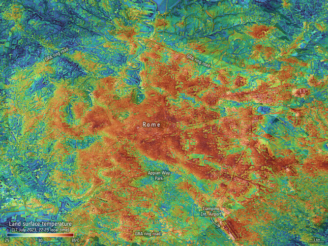
Confirmed by the World Meteorological Organization, July 2023 was the hottest month on record, with high-impact weather continuing through August. These records are based on air temperatures, but measurements of the temperature of Earth’s surface taken from space are also essential to tracking the impact of climate change, and to being better prepared for such extremes – especially when it comes to cities where stifling urban heat islands form.
Wildfires continue to rage in Greece
24.8.2023 15:07 ESA Observing the Earth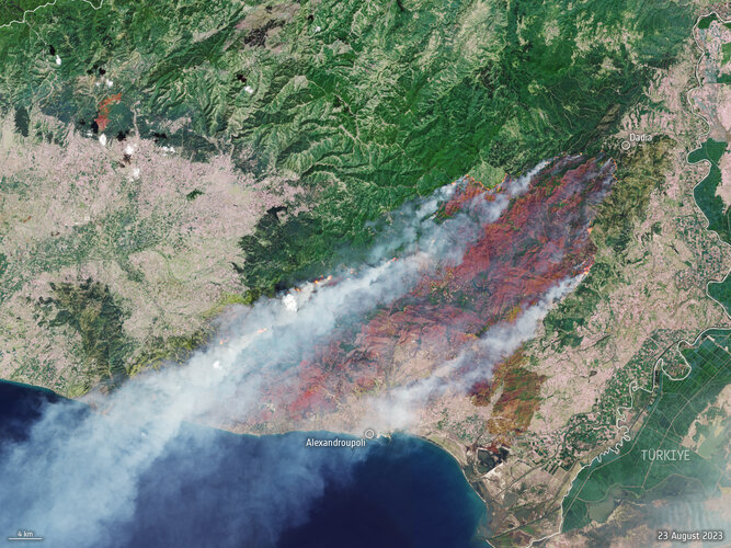 Image:
A month after fires ravaged the island of Rhodes in July 2023, more fires have ripped through Greece this week as southern Europe swelters under a late summer heatwave. This Copernicus Sentinel-2 image shows the ongoing blaze near Alexandroupoli in the Evros region of northeast Greece – close to the Türkiye border.
Image:
A month after fires ravaged the island of Rhodes in July 2023, more fires have ripped through Greece this week as southern Europe swelters under a late summer heatwave. This Copernicus Sentinel-2 image shows the ongoing blaze near Alexandroupoli in the Evros region of northeast Greece – close to the Türkiye border.
EUSPA Industry Days: CASSINI Hackathons & Matchmaking Procurement in a nutshell
24.8.2023 10:54 European GNSS Agency
CASSINI is the European Union's initiative to support entrepreneurs, start-ups and SMEs in the space industry, including New Space, during 2021-2027. The initiative is open to all areas of the EU Space Programme, and covers both upstream (i.e. nanosats, launchers, etc. and downstream (i.e. products/services enabled by space data, etc.). CASSINI includes a €1 billion EU seeds and growth fund, hackathons and mentoring, prizes, a business accelerator, partnering and matchmaking.
A recently launched EUSPA procurement (OJ contract Notice 2023/S 139-441759) will cover two lots: Lot 1 CASSINI Hackathons (€4,700,000.00) and Lot 2 CASSINI Matchmaking (€2,800,000.00).
The tender documents are available here
CASSINI Hackathons
Europe-wide CASSINI Hackathons offer a chance to develop digital applications building on space data, including satellite images and positioning services. Lot 1 will cover the support in the hackathon implementation, including selecting and supporting the local organisers for two annual CASSINI hackathons, developing communication and promotion plans, ensuring event efficiency, and supporting EUSPA in the mentoring sessions for the hackathon winners.
CASSINI Matchmaking
CASSINI Matchmaking connects start-ups, scaleups and SMEs with corporates and investors to accelerate their business. This Lot will cover the organisation of a series of matchmaking events, aiming to expand professional networks and improve the start-ups and SMEs ability to enter new markets and achieve rapid revenue growth. The events will involve two types of matchmaking: i) investor matchmaking, and ii) industrial partnering.
A dedicated webinar will take place on 8 September 2023 at 14:00 CEST.
You can join the webinar here.
The deadline for submissions to the call is 13 October 2023 – 17:00 (Brussels time).
Media note: This feature can be republished without charge provided the European Union Agency for the Space Programme (EUSPA) is acknowledged as the source at the top or the bottom of the story. You must request permission before you use any of the photographs on the site. If you republish, we would be grateful if you could link back to the EUSPA website (http://www.euspa.europa.eu).
EUSPA Industry Days: CASSINI Hackathons & Matchmaking Procurement in a nutshell
24.8.2023 10:54 European GNSS AgencyCASSINI is the European Union's initiative to support entrepreneurs, start-ups and SMEs in the space industry, including New Space, during 2021-2027. The initiative is open to all areas of the EU Space Programme, and covers both upstream (i.e. nanosats, launchers, etc. and downstream (i.e. products/services enabled by space data, etc.). CASSINI includes a €1 billion EU seeds and growth fund, hackathons and mentoring, prizes, a business accelerator, partnering and matchmaking.
A recently launched EUSPA procurement (OJ contract Notice 2023/S 139-441759) will cover two lots: Lot 1 CASSINI Hackathons (€4,700,000.00) and Lot 2 CASSINI Matchmaking (€2,800,000.00).
The tender documents are available here
CASSINI Hackathons
Europe-wide CASSINI Hackathons offer a chance to develop digital applications building on space data, including satellite images and positioning services. Lot 1 will cover the support in the hackathon implementation, including selecting and supporting the local organisers for two annual CASSINI hackathons, developing communication and promotion plans, ensuring event efficiency, and supporting EUSPA in the mentoring sessions for the hackathon winners.
CASSINI Matchmaking
CASSINI Matchmaking connects start-ups, scaleups and SMEs with corporates and investors to accelerate their business. This Lot will cover the organisation of a series of matchmaking events, aiming to expand professional networks and improve the start-ups and SMEs ability to enter new markets and achieve rapid revenue growth. The events will involve two types of matchmaking: i) investor matchmaking, and ii) industrial partnering.
A dedicated webinar will take place on 11 September 2023 at 11:00 CEST.
The Q&A from the webinar will be available on the e-tender portal etendering.ted.europa.eu in due time.
You can join the webinar here.
The deadline for submissions to the call is 13 October 2023 – 17:00 (Brussels time).
Media note: This feature can be republished without charge provided the European Union Agency for the Space Programme (EUSPA) is acknowledged as the source at the top or the bottom of the story. You must request permission before you use any of the photographs on the site. If you republish, we would be grateful if you could link back to the EUSPA website (http://www.euspa.europa.eu).
EUSPA Industry Days: CASSINI Hackathons & Matchmaking Procurement in a nutshell
24.8.2023 10:54 European GNSS AgencyCASSINI is the European Union's initiative to support entrepreneurs, start-ups and SMEs in the space industry, including New Space, during 2021-2027. The initiative is open to all areas of the EU Space Programme, and covers both upstream (i.e. nanosats, launchers, etc. and downstream (i.e. products/services enabled by space data, etc.). CASSINI includes a €1 billion EU seeds and growth fund, hackathons and mentoring, prizes, a business accelerator, partnering and matchmaking.
A recently launched EUSPA procurement (OJ contract Notice 2023/S 139-441759) will cover two lots: Lot 1 CASSINI Hackathons (€4,700,000.00) and Lot 2 CASSINI Matchmaking (€2,800,000.00).
The tender documents are available here
CASSINI Hackathons
Europe-wide CASSINI Hackathons offer a chance to develop digital applications building on space data, including satellite images and positioning services. Lot 1 will cover the support in the hackathon implementation, including selecting and supporting the local organisers for two annual CASSINI hackathons, developing communication and promotion plans, ensuring event efficiency, and supporting EUSPA in the mentoring sessions for the hackathon winners.
CASSINI Matchmaking
CASSINI Matchmaking connects start-ups, scaleups and SMEs with corporates and investors to accelerate their business. This Lot will cover the organisation of a series of matchmaking events, aiming to expand professional networks and improve the start-ups and SMEs ability to enter new markets and achieve rapid revenue growth. The events will involve two types of matchmaking: i) investor matchmaking, and ii) industrial partnering.
A dedicated webinar will take place on 8 September 2023 at 14:00 CEST.
You can join the webinar here.
The deadline for submissions to the call is 13 October 2023 – 17:00 (Brussels time).
Media note: This feature can be republished without charge provided the European Union Agency for the Space Programme (EUSPA) is acknowledged as the source at the top or the bottom of the story. You must request permission before you use any of the photographs on the site. If you republish, we would be grateful if you could link back to the EUSPA website (http://www.euspa.europa.eu).
Point Cloud of Saloma Link Bridge in Kuala Lumpur by Lixel X1
24.8.2023 5:35 Satlab GeosolutionsImmerse yourself in the captivating data visualization of Kuala Lumpur’s Saloma Link Bridge, brought to […]
The post Point Cloud of Saloma Link Bridge in Kuala Lumpur by Lixel X1 appeared first on Global Satellite Positioning Solutions | SatLab Geosolutions AB.
Geo.knihovny.cz - nová brána do světa geografických informací [Knihovna geografie, byTopic]
24.8.2023 0:00 Katedra aplikované geoinformatiky a kartografie Přf UK Databáze GEOBIBLINE (Geografická bibliografie ČR online), která zpřístupňuje bibliografické záznamy bohemikálních geografických a kartografických dokumentů od 15. století do současnosti, se stala primárním zdrojem nové oborové brány Geo.knihovny.cz. Databáze byla obohacena o oborově příbuzná data z ostatních zdrojů zapojených do portálu Knihovny.cz, takže je nyní možné prohledávat přes 316 tisíc záznamů.Měřická technika pro dokumentaci terénu. Geopen a Telink zvou na podzimní setkání
23.8.2023 19:40 ZeměměřičSpolečnosti GEOPEN a TELINK zvou na představení a praktické předvedení ovládání nejmodernějších měřických systémů, využitelných pro dokumentaci terénu. Akce se uskuteční v úterý 19. září 2023 od 9:00 hod. v Praze. Vstup je zdarma, vyžadována je pouze registrace účastníků předem, aby pořadatelé mohli zajistit dostatečné prostory pro prezentace a také drobné občerstvení pro každého účastníka. Představena bude následující technika: drony DJI […]
The post Měřická technika pro dokumentaci terénu. Geopen a Telink zvou na podzimní setkání appeared first on Zeměměřič.
Nový e-learning kurz Autodesk Docs
23.8.2023 14:20 Arkance SystemsNový e-learningový kurz CDE aplikace Autodesk Docs
Zpráva Nový e-learning kurz Autodesk Docs pochází z arkance-systems.cz.
Žiadosť o súčinnosť samospráv pri zvyšovaní kvality služieb poskytovaných občanom
23.8.2023 11:00
ÚGKK SR
ÚGKK SR (Úrad geodézie, kartografie a katastra) a KGK (Komora geodetov a kartografov) zaslali všetkým stupňom samospráv a stavebným úradom na Slovensku spoločný osvetový list so zámerom zvýšenia odborného povedomia hlavne o grafických informáciách poskytovaných z Geoportálu, teda z Mapového klienta ZBGIS a portálu ESKN.
BIM Open 2023 - Pozvánka na konferenci o BIMu prakticky a otevřeně
22.8.2023 9:51 Adeon
Zúčastněte se letošní konference BIM Open 2023. Právě jsme spustili jsme registraci na tento již 8. ročník BIM konference. Konference […]
The post BIM Open 2023 - Pozvánka na konferenci o BIMu prakticky a otevřeně appeared first on Adeon CZ.
BIM Open 2023 - Pozvánka na konferenci o BIMu prakticky a otevřeně
22.8.2023 9:51 AdeonZúčastněte se letošní konference BIM Open 2023. Právě jsme spustili jsme registraci na tento již 8. ročník BIM konference. Konference […]
The post BIM Open 2023 - Pozvánka na konferenci o BIMu prakticky a otevřeně appeared first on Adeon CZ.
Zahájení revize katastru nemovitostí
22.8.2023 9:26 ČÚZK - předpisy a opatření Katastrální úřad pro Liberecký kraj - Katastrální pracoviště Česká Lípa zveřejnil novou aktualitu: Katastrální úřad pro Liberecký kraj, Katastrální pracoviště Česká Lípa informuje o tom, že dne 1. 11. 2023 zahájí revizi katastru nemovitostí v následujících katastrálních územích: Pihel, Dobranov, Horní Police, Hamr na Jezeře, Radvanec, Krompach, Volfartice. Podrobnosti viz úřední deska.O českém bezpilotním průmyslu a aktivitách UAVA v novém čísle časopisu Ministerstva zahraničních věcí
22.8.2023 8:24 UAVAO českém bezpilotním průmyslu a jeho potenciálu ve světě a aktivitách Aliance v rámci ekonomické diplomacie v novém čísle časopisu Ministerstva zahraničních věcí Moderní ekonomická diplomacie MZV ČR.
The post O českém bezpilotním průmyslu a aktivitách UAVA v novém čísle časopisu Ministerstva zahraničních věcí appeared first on UAV Aliance pro bezpilotní letecký průmysl.
O českém bezpilotním průmyslu a aktivitách UAVA v novém čísle časopisu Ministerstva zahraničních věcí
22.8.2023 8:03 UAVA O českém bezpilotním průmyslu a jeho potenciálu ve světě a aktivitách Aliance v rámci ekonomické diplomacie v novém čísle časopisu Ministerstva zahraničních věcí Moderní ekonomická diplomacie MZV ČR. ČESKÉ NEBE PLNÉ HVĚZD: BEZPILOTNÍ TECHNOLOGIE, KTERÉ PATŘÍ DO SVĚTOVÉ ŠPIČKYAliance podepsala s JUIDA Japan UAS Industrial Development Association Memorandum of Understanding
21.8.2023 16:02 UAVAAliance pro bezpilotní letecký průmysl podepsala s JUIDA (Japan UAS Industrial Development Association) Memorandum of Understanding a bude prohlubovat spolupráci s japonskými partnery v oblasti dronů a navazuje tak na první český stánek v rámci letošní akce Japan Drones na konci června 2023.
The post Aliance podepsala s JUIDA Japan UAS Industrial Development Association Memorandum of Understanding appeared first on UAV Aliance pro bezpilotní letecký průmysl.
Aliance podepsala s JUIDA Japan UAS Industrial Development Association Memorandum of Understanding
21.8.2023 12:57 UAVA Aliance pro bezpilotní letecký průmysl podepsala s JUIDA (Japan UAS Industrial Development Association) Memorandum of Understanding a bude prohlubovat spolupráci s japonskými partnery v oblasti dronů a navazuje tak na první český stánek v rámci letošní akce Japan Drones na konci června 2023.Informatička/informatik SŠ
21.8.2023 11:26 ČÚZK - předpisy a opatření Výzkumný ústav geodetický, topografický a kartografickývypisuje výběrové řízení na místo
Informatička/informatik SŠ
Vedoucí oddělení personálně správního
21.8.2023 11:26 ČÚZK - předpisy a opatření Výzkumný ústav geodetický, topografický a kartografickývypisuje výběrové řízení na místo
Vedoucí oddělení personálně správního
Vedoucí oddělení personálně správního
21.8.2023 11:26 ČÚZK - volná místa Výzkumný ústav geodetický, topografický a kartografický vypisuje výběrové řízení na místo Vedoucí oddělení personálně správníhoVedoucí oddělení personálně správního
21.8.2023 11:26 ČÚZK /Urady/VUGTK/Volna-mista/Informaticka-informatik-SSInformatička/informatik SŠ
21.8.2023 11:26 ČÚZK - volná místa Výzkumný ústav geodetický, topografický a kartografický vypisuje výběrové řízení na místo Informatička/informatik SŠValná hromada APG se koná již v září. Následovat ji bude konference Geomatika 2023
19.8.2023 22:46 ZeměměřičPředstavenstvo Asociace podnikatelů v geomatice svolává na čtvrtek 21. září 2023 od 10:00 valnou hromadu, která se bude konat v hotelu Panorama, Milevská 1695/7, Praha 4. Program valné hromady: Zahájení(ověření usnášeníschopnosti, volba předsedajícího VH, zapisovatele a skrutátorů) Úvodní slovo výkonného ředitele Úvodní slovo předsedy představenstva Zpráva představenstva Zpráva dozorčí rady Předání plakety čestnému členovi Zpráva vedoucích pracovních skupin Schválení […]
The post Valná hromada APG se koná již v září. Následovat ji bude konference Geomatika 2023 appeared first on Zeměměřič.
Valná hromada APG se koná již v září. Doplní ji konference Geomatika 2023
19.8.2023 22:46 ZeměměřičPředstavenstvo Asociace podnikatelů v geomatice svolává na čtvrtek 21. září 2023 od 10:00 valnou hromadu, která se bude konat v hotelu Panorama, Milevská 1695/7, Praha 4. Program valné hromady: Zahájení(ověření usnášeníschopnosti, volba předsedajícího VH, zapisovatele a skrutátorů) Úvodní slovo výkonného ředitele Úvodní slovo předsedy představenstva Zpráva představenstva Zpráva dozorčí rady Předání plakety čestnému členovi Zpráva vedoucích pracovních skupin Schválení […]
The post Valná hromada APG se koná již v září. Doplní ji konference Geomatika 2023 appeared first on Zeměměřič.
DAEX DESIGN Plus – vše pro truhláře a nábytkáře v jednom v letní akční ceně
19.8.2023 11:55 ŠPINAR - softwareVážení zákazníci, připravili jsme pro Vás DAEX DESIGN Plus pro výrobce a návrháře nábytku a interiérů s rozšiřujícími bonusy do 7. 5. 2023
The post DAEX DESIGN Plus – vše pro truhláře a nábytkáře v jednom v letní akční ceně appeared first on ŠPINAR – software.
DAEX DESIGN Plus – vše pro truhláře a nábytkáře v jednom v letní akční ceně
19.8.2023 11:55 ŠPINAR - software Vážení zákazníci, připravili jsme pro Vás DAEX DESIGN Plus pro výrobce a návrháře nábytku a interiérů s rozšiřujícími bonusy do 7. 5. 2023Nová učebnice Pokročilé zpracování geodat
18.8.2023 14:47 Katedra geoinformatiky UP OlomoucV rámci projektu UrbanDM vyšel nová učebnice Pokročilé zpracování geodat, která obsahuje teoretické kapitoly pro výuku v rámci předmětu KGI/POGEO Pokročilé zpracování geodat pro magisterský studijní program Geoinformatika a kartografie. Předkládaná učebnice představuje teoretický přehled zaměřený na vybrané metody prostorové statistiky. Primárním cílem textu je poskytnout studentům geoinformatiky a příbuzných oborů studijní materiál, který doplňuje […]
The post Nová učebnice Pokročilé zpracování geodat appeared first on Katedra geoinformatiky.
Nová učebnice Pokročilé zpracování geodat
18.8.2023 14:47 Katedra geoinformatiky UP Olomouc V rámci projektu UrbanDM vyšel nová učebnice Pokročilé zpracování geodat, která obsahuje teoretické kapitoly pro výuku v rámci předmětu KGI/POGEO Pokročilé zpracování geodat pro magisterský studijní program Geoinformatika a kartografie. Předkládaná učebnice představuje teoretický přehled zaměřený na vybrané metody prostorové statistiky. Primárním cílem textu je poskytnout studentům geoinformatiky a příbuzných oborů studijní materiál, který doplňuje […]Nová učebnice Pokročilé zpracování geodat
18.8.2023 14:47 Katedra geoinformatiky UP Olomouc V rámci projektu UrbanDM vyšel nová učebnice Pokročilé zpracování geodat, která obsahuje teoretické kapitoly pro výuku v rámci předmětu KGI/POGEO Pokročilé zpracování geodat pro magisterský studijní program Geoinformatika a kartografie. Předkládaná učebnice představuje teoretický přehled zaměřený na vybrané metody prostorové statistiky. Primárním cílem textu je poskytnout studentům geoinformatiky a příbuzných oborů studijní materiál, který doplňuje […]vrchní referent/rada - kontrola aktualizace v oddělení aktualizace PI KN Katastrálního pracoviště Če
18.8.2023 12:17 ČÚZK - předpisy a opatření Katastrální úřad pro Jihočeský kraj Katastrální pracoviště České Budějovicevypisuje výběrové řízení na místo
vrchní referent/rada - kontrola aktualizace v oddělení aktualizace PI KN Katastrálního pracoviště České Budějovice (ID SM 30000108/30003732)
vrchní referent/rada - kontrola aktualizace v oddělení aktualizace PI KN Katastrálního pracoviště Če
18.8.2023 12:17 ČÚZK /Urady/Katastralni-urady/Katastralni-urady/Katastralni-urad-pro-Jihocesky-kraj/Uredni-deska/Oznameni-a-jina-uredni-sdeleni/Volna-mista/DMS/vrchni-referent-rada-kontrola-aktualizace-v-oddelevrchní referent/rada - kontrola aktualizace v oddělení aktualizace PI KN Katastrálního pracoviště Če
18.8.2023 12:17 ČÚZK - volná místa Katastrální úřad pro Jihočeský kraj Katastrální pracoviště České Budějovice vypisuje výběrové řízení na místo vrchní referent/rada - kontrola aktualizace v oddělení aktualizace PI KN Katastrálního pracoviště ČeI/NAV improvements are now available to all Galileo Open Service users
18.8.2023 9:44 European GNSS Agency
The Galileo OS has been upgraded with three new features added to its I/NAV message, one of the four message types broadcast by Galileo satellites. Collectively referred to simply as I/NAV improvements, these features are now available to all Galileo Open Service users.
Starting on 12 August 2023, the gradual process of upgrading the operational Galileo FOC constellation satellites has been finalized, and the I/NAV improvements are openly accessible through the I/NAV message carried by the E1-B signal.
"These new features improve the robustness and the time required for Galileo navigation data demodulation. In challenging environments, they enhance the Galileo OS capability to solve the user clock uncertainty", says Guerric Pont, EUSPA Galileo Exploitation Programme Manager.
In simple terms, in case you have experienced delays when turning on your GNSS device, the I/NAV improvements can reduce them significantly. Let’s have a look at the features more in detail.
Faster and more robust positioning
The Reed Solomon Outer Forward Error Correction (RS FEC2) increases demodulation robustness at all times and therefore enhances the sensitivity. It also improves the overall time to retrieve Clock and Ephemeris Data (time to CED) thanks to the broadcast of additional, redundant CED information, while allowing for the device to restore potentially corrupted data bits autonomously.
The Reduced Clock and Ephemeris Data (RedCED) allows for a fast-initial positioning, albeit with lower than nominal accuracy, by decoding one single I/NAV word, while waiting to receive the four I/NAV words carrying the full-precision CED.
The combination of these two features allows not only to obtain a first coarse position solution much faster (RedCED), but also to reduce significantly the time required to obtain a first full accuracy solution (RS FEC2). This translates into a much-reduced Time to First Fix (TTFF) for the OS users, particularly when operating in harsh environments.
Benefitting applications working in GNSS-assisted mode
The improvements also benefit applications working in assisted GNSS (A-GNSS) mode, through the Secondary Synchronisation Pattern (SSP). In A-GNSS mode, when navigation data is received from non-GNSS channels and the receiver’s knowledge of the Galileo System Time is affected by a relatively large error, typically in the order of a few seconds, the clock uncertainty must be resolved quickly and stably.
With the I/NAV improvements, receivers will be able to do this via the new SSP feature, thus reducing the TTFF also in A-GNSS mode.
For more information, please see the I/NAV Navigation Message Improvements Info Note.
Testing campaign targeting receivers to follow
While the I/NAV improvements are fully operational, the European Union Agency for the Space Programme (EUSPA) will launch a testing campaign open to receiver manufacturers, that will consist of several testing windows. The tests will allow the participants to have a confirmation of the correct implementation of the OS SIS ICD 2.0, i.e. the right processing of the three I/NAV improvements in their products.
The tests will be conducted at the laboratories of the European Commission’s Joint Research Centre in Ispra, Italy, and of the European Space Agency ESA/ESTEC in Noordwijk, The Netherlands. EUSPA will assign each applicant to one of the two laboratories depending on the specific conditions and availability.
Media note: This feature can be republished without charge provided the European Union Agency for the Space Programme (EUSPA) is acknowledged as the source at the top or the bottom of the story. You must request permission before you use any of the photographs on the site. If you republish, we would be grateful if you could link back to the EUSPA website (http://www.euspa.europa.eu).
APGEO - Valná hromada APG 2023
18.8.2023 2:00 Asociace podnikatelů v geomatice Srdečně Vás zveme na valnou hromadu APG, která se uskuteční 21. 9. 2023 v Praze.EUSPA procurement to support the security accreditation of the EU Space Programme
17.8.2023 15:28 European GNSS Agency
EUSPA’s mission is multifaceted and includes, among other responsibilities, the overall safety and security of the EU Space Programme and its components in space and on the ground. It guarantees that Europe’s positioning systems, Galileo and EGNOS emit secure signals and that their respective ground infrastructures (sensors, antennas, stations) remain intact. Moreover, EUSPA provides security expertise to other components of the Space Programme such as GOVSATCOM and the Space Situational Awareness.
The issued procurement (OJ contract Notice 2023/S 140-447337) will cover support to the SAB secretariat including to the secretariat of its Subordinate Bodies and security assurance support with respect to the accreditation activities necessary for the governmental infrastructure and services of the new EU space Programme component, IRIS2.
The tender documents are available here
The security accreditation activities of the SAB encompass Galileo, EGNOS, GOVSATCOM, SSA, Copernicus and IRIS2. The tasks include, among others, support in core security accreditation activities such as assessment of compliance status of security requirements, security risk assessment, security audits including cyber audits, and penetration testing.
A dedicated webinar will take place on 22 August 2023 at 10:30 CEST. You can join the webinar here.
The deadline for submissions is 11 September 2023 - 23:59 (Brussels time).
About the Security Accreditation Board
The SAB is the security accreditation authority for all of the EU Space Programme’s components. It ensures that systems comply with the relevant security requirements and provides statements of approval to operate the systems and services with the objective that the EU space-based services and data can be used by the EU citizens in a trusted way.
An independent body within EUSPA, the SAB is composed of a representative from each Member State, the Commission, and the High Representative for the Union for Foreign Affairs and Security Policy. The SAB decisions are taken by professionals in a strictly independent manner including with regard to the European Commission and other bodies such as EUSPA or ESA that are responsible for the implementation of the components and provision of services.
More information on the SAB way of working can be found in the SAB Rules of Procedure.
Media note: This feature can be republished without charge provided the European Union Agency for the Space Programme (EUSPA) is acknowledged as the source at the top or the bottom of the story. You must request permission before you use any of the photographs on the site. If you republish, we would be grateful if you could link back to the EUSPA website (http://www.euspa.europa.eu).