


![]()

zprávy
zdroje zpráv:První kroky v ArcGIS GeoBIM
25.1.2022 10:07 blog ARCDATA Světy GIS a BIM se propojují v prostředí aplikace ArcGIS GeoBIM. Naučíme vás, jak ji správně nastavit, abyste spolupráci obou těchto systémů mohli využívat i ve vašich projektech.ArcGIS GeoBIM
25.1.2022 10:07 blog ARCDATA Jednou z posledních novinek mezi aplikacemi ArcGIS je ArcGIS GeoBIM, která propojuje světy GIS a BIM. Pojďme si ji v tomto článku představit.20220125_Odborný / vrchní referent oddělení aktualizace a dokumentace KN
25.1.2022 9:43 ČÚZK - předpisy a opatření Katastrální úřad pro Středočeský kraj - Katastrální pracoviště Beroun Vyhlášení výběrového řízení: Odborný / vrchní referent oddělení aktualizace a dokumentace KN V části "Úřední deska", v sekci "Oznámení a jiná úřední sdělení" bylo vystaveno "Oznámení o vyhlášení výběrového řízení na obsazení služebního místa Odborný / vrchní referent oddělení aktualizace a dokumentace KN"20220125_Odborný / vrchní referent oddělení aktualizace a dokumentace KN
25.1.2022 9:43 ČÚZK /Urady/Katastralni-urady/Katastralni-urady/Katastralni-urad-pro-Stredocesky-kraj/Katastralni-pracoviste/KP-Beroun/O-uradu/Aktuality/20210113_odborny-rada,-reditel-Katastralniho-(2)Odborný / vrchní referent oddělení aktualizace a dokumentace KN
25.1.2022 9:42 ČÚZK - předpisy a opatření Katastrální úřad pro Středočeský kraj - Katastrální pracoviště Berounvypisuje výběrové řízení na místo Odborný / vrchní referent oddělení aktualizace a dokumentace KN
Odborný / vrchní referent oddělení aktualizace a dokumentace KN
Odborný / vrchní referent oddělení aktualizace a dokumentace KN
25.1.2022 9:42 ČÚZK /Urady/Katastralni-urady/Katastralni-urady/Katastralni-urad-pro-Stredocesky-kraj/Uredni-deska/Oznameni-a-jina-uredni-sdeleni/Volna-mista/Odborny-vrchni-referent-oddeleni-aktualizace-a-dOdborný / vrchní referent oddělení aktualizace a dokumentace KN
25.1.2022 9:42 ČÚZK - volná místa Katastrální úřad pro Středočeský kraj - Katastrální pracoviště Beroun vypisuje výběrové řízení na místo Odborný / vrchní referent oddělení aktualizace a dokumentace KN20220125_Vedoucí oddělení obnovy katastrálního operátu 03110 - odborný rada Technické sekce KÚ SČK
25.1.2022 9:03 ČÚZK - předpisy a opatření Katastrální úřad pro Středočeský kraj Vyhlášení výběrového řízení: Vedoucí oddělení obnovy katastrálního operátu 03110 - odborný rada Technické sekce Katastrálního úřadu pro Středočeský kraj V části "Úřední deska", v sekci "Oznámení a jiná úřední sdělení" bylo vystaveno "Oznámení o vyhlášení výběrového řízení na obsazení systemizovaného místa Vedoucí oddělení obnovy katastrálního operátu 03110 - odborný rada Technické sekce Katastrálního úřadu pro Středočeský kraj"20220125_Vedoucí oddělení obnovy katastrálního operátu 03110 - odborný rada Technické sekce KÚ SČK
25.1.2022 9:03 ČÚZK /Urady/Katastralni-urady/Katastralni-urady/Katastralni-urad-pro-Stredocesky-kraj/O-uradu/Aktuality/20220105_Rada-odborny-rada-–-interni-auditor-(1)Vedoucí oddělení obnovy katastrálního operátu 03110 - odborný rada Technické sekce Katastrálního úřa
25.1.2022 9:01 ČÚZK - předpisy a opatření Katastrální úřad pro Středočeský kraj - technická sekcevypisuje výběrové řízení na místo Vedoucí oddělení obnovy katastrálního operátu 03110 - odborný rada Technické sekce Katastrálního úřadu pro Středočeský kraj
Vedoucí oddělení obnovy katastrálního operátu 03110 - odborný rada Technické sekce Katastrálního úřadu pro Středočeský kraj
Vedoucí oddělení obnovy katastrálního operátu 03110 - odborný rada Technické sekce Katastrálního úřa
25.1.2022 9:01 ČÚZK /Urady/Katastralni-urady/Katastralni-urady/Katastralni-urad-pro-Stredocesky-kraj/Uredni-deska/Oznameni-a-jina-uredni-sdeleni/Volna-mista/Vedouci-oddeleni-obnovy-katastralniho-operatu-0311Vedoucí oddělení obnovy katastrálního operátu 03110 - odborný rada Technické sekce Katastrálního úřa
25.1.2022 9:01 ČÚZK - volná místa Katastrální úřad pro Středočeský kraj - technická sekce vypisuje výběrové řízení na místo Vedoucí oddělení obnovy katastrálního operátu 03110 - odborný rada Technické sekce Katastrálního úřaMapTiler Desktop 11(webinář)
25.1.2022 8:25 GISportal.cz
Společnost MapTiler Vás zve na webinář, na kterém představí novinky je jejich produktu MapTiler Desktop 11. Jedná se o software, který umožňuje přeměnit obrázky nebo data do mapových dlaždic. Webinář se bude konat ve středu 26. ledna v 17:00. Více informací naleznete na https://www.maptiler.com/desktop/webinar-2022/. Registrace je zdarma.
The post MapTiler Desktop 11(webinář) appeared first on GISportal.cz.
MapTiler Desktop 11(webinář)
25.1.2022 8:25 GISportal.czSpolečnost MapTiler Vás zve na webunář, na kterém představí novinky je jejich produktu MapTiler Desktop 11. Jedná se o software, který umožňuje přeměnit obrázky nebo data do mapových dlaždic. Webinář se bude konat ve středu 26. ledna v 17:00. Více informací naleznete na https://www.maptiler.com/desktop/webinar-2022/. Registrace je zdarma.
The post MapTiler Desktop 11(webinář) appeared first on GISportal.cz.
Nabídka 2ks vozidel k bezúplatnému převodu pro OSS
25.1.2022 8:09 ČÚZK /Urady/Katastralni-urady/Katastralni-urady/Katastralni-urad-pro-Moravskoslezsky-kraj/Nabidky-majetku/Nabidka-2ks-vozidel-k-bezuplatnemu-prevodu-pro-OSSNabídka 2ks vozidel k bezúplatnému převodu pro OSS
25.1.2022 8:09 ČÚZK - předpisy a opatřeníKatastrální úřad pro Moravskoslezský kraj nabízí nepotřebný majetek k odkupu. Jedná se o
Nabídka 2ks vozidel k bezúplatnému převodu pro OSS
Nová retenční nádrž na Vinicích
25.1.2022 8:09 Hrdlička Plzeň buduje novou retenční nádrž, která zadrží až 6000 kubíků vody.Focus on drone mapping | Geo Week 2022
25.1.2022 3:33 Satlab GeosolutionsEvent: Focus on drone mapping 2021 | Geo Week 2022 Date: 6th-8th February 2022 Geo Week 2022 will take place on February 6-8, 2022 in Denver, Colorado. It contains AEC Next Technology Expo & Conference, International Lidar Mapping Forum, SPAR 3D Expo & Conference, and partner events ASPRS Annual Conference and USIBD Annual Symposium. The joining […]
The post Focus on drone mapping | Geo Week 2022 appeared first on SatLab – Global Satellite Positioning Solutions.
Presentation Proposals Invited for GIS-Pro 2022 in Boise, Idaho
25.1.2022 0:50 GISCafe.com Webcasts-Webinars Des Plaines, IL (January 24, 2022) URISA's 60th Anniversary Conference, GIS-Pro 2022, will be hosted in Boise, Idaho, in partnership with …Join Skyline, Lead'Air, & RIEGL to see stunning 3D and analytics from the new MetaDuo system
24.1.2022 23:48 GISCafe.com Webcasts-WebinarsGeo Week 2022 Exhibit Floor is Sold Out & Live Event Going Forward Feb 6-8 in Denver
24.1.2022 21:42 GISCafe.com Webcasts-Webinars 140+ geospatial and built world technology solutions providers to exhibit at Geo WeekPORTLAND, Maine, Jan. 24, 2022 — (PRNewswire) — …
Podcast How digital engineering is improving project delivery
24.1.2022 21:24 Bentley SystemsPressCoverage
New Civil Engineer, UK&I
Read the articleMagnolia River Announces the Acquisition of Storti Quality Services
24.1.2022 18:08 GISCafe.com Webcasts-Webinars Magnolia River, a leading provider of infrastructure inspection, engineering, GIS, and technology solutions, is pleased to announce the acquisition …Deepspatial Inc. Expands Partner Program and Announces New Contract
24.1.2022 16:36 GISCafe.com Webcasts-Webinars Marks Entry in New Infrastructure and Urban Planning SectorKey Contracts in Pipeline to Play Crucial Role in Growth of Deepspatial
TORONTO — …
LandScan Invests in Future of Geospatial Software With Recent Acquisitions
24.1.2022 16:36 GISCafe.com Webcasts-Webinars MADISON, Wis., Jan. 21, 2022 (GLOBE NEWSWIRE) -- LandScan has announced the acquisition of three companies as part of its geospatial software …Intermap Announces a New Contract with a Leading European Airline to Provide Elevation Data as a Service for Flight Planning Operations
24.1.2022 16:36 GISCafe.com Webcasts-Webinars DENVER, Jan. 24, 2022 — (PRNewswire) — Intermap Technologies (TSX: IMP) (OTCQX: ITMSF) ("Intermap" or the "Company"), a global leader in …Woolpert Contracted by Denver International Airport for On-Call Geospatial Support Services
24.1.2022 16:36 GISCafe.com Webcasts-Webinars The firm will provide survey, engineering, and GIS data acquisition and development for the third-busiest airport in the world.DENVER, Jan. 24, 2022 …
STOP-STAV v k. ú. Dolní Sytová
24.1.2022 16:19 ČÚZK - předpisy a opatření Český úřad zeměměřický a katastrální zveřejnil novou aktualitu: V katastrálním území Dolní Sytová byl vyhlášen STOP-STAV pro všechny zápisy do katastru (vklady a záznamy), (rezervace ZPMZ) a rezervace nových parcelních čísel do doby zplatnění obnoveného katastrálního operátu mapováním.Listiny budou pouze přijaty a zaplombovány.
Geodetickou veřejnost tímto žádáme, aby danému STOP-STAVU přizpůsobili plánované, nebo rozpracované zakázky v tomto katastrálním území.
STOP-STAV v k. ú. Dolní Sytová
24.1.2022 16:19 ČÚZK - předpisy a opatření Český úřad zeměměřický a katastrální zveřejnil novou aktualitu: V katastrálním území Dolní Sytová byl vyhlášen STOP-STAV pro všechny zápisy do katastru (vklady a záznamy), rezervace ZPMZ a nových parcelních čísel do doby zplatnění obnoveného katastrálního operátu mapováním.Listiny budou pouze přijaty a zaplombovány.
Geodetickou veřejnost tímto žádáme, aby danému STOP-STAVU přizpůsobili plánované, nebo rozpracované zakázky v tomto katastrálním území.
STOP-STAV v k. ú. Dolní Sytová
24.1.2022 16:19 ČÚZK /Urady/Katastralni-urady/Katastralni-urady/Katastralni-urad-pro-Liberecky-kraj/Katastralni-pracoviste/KP-Semily/O-uradu/Aktuality/STOP-STAV-v-k-u-Dolni-SytovaESA supports the White House on greenhouse gas monitoring
24.1.2022 14:50 ESA Observing the Earth
When Joe Biden was inaugurated as President one year ago, he fulfilled his promise to rejoin the Paris Agreement and set a course for the US to tackle the climate crisis by supporting global efforts to limit global warming. ESA recently joined the President’s Council of Advisors on Science and Technology by public video link to share European plans and expertise on measuring carbon dioxide and methane from space.
Odborný referent/vrchní referent v oddělení právních vztahů k nemovitostem na Katastrálním pracovišt
24.1.2022 12:51 ČÚZK - volná místa Katastrální úřad pro Jihomoravský kraj Katastrální pracoviště Vyškov vypisuje výběrové řízení na místo Odborný referent/vrchní referent v oddělení právních vztahů k nemovitostem na Katastrálním pracovištOdborný referent/vrchní referent v oddělení právních vztahů k nemovitostem na Katastrálním pracovišt
24.1.2022 12:51 ČÚZK - předpisy a opatření Katastrální úřad pro Jihomoravský kraj Katastrální pracoviště Vyškovvypisuje výběrové řízení na místo
Odborný referent/vrchní referent v oddělení právních vztahů k nemovitostem na Katastrálním pracovišti Vyškov
Ukončení provozu nástroje Eshop
24.1.2022 11:39 CENIA - národní geoportál INSPIRE Vážení uživatelé Národní geoportálu INSPIRE, tímto Vám oznamujeme, že Od 1. 1. 2022 byl na Národním Geoportálu INSPIRE ukončen provoz nástroje Eshop. Děkujeme za pochopení.Galileo satellites 27-28 reach final orbit; initiate testing phase
24.1.2022 10:59 European GNSS Agency
The Payload In Orbit Testing activities is the last stage of the Early Operations Phase. It will enable the Galileo satellites 27-28 to enter service provision and their signals to become available to end-users down on Earth.
2022 is the year of delivery for EUSPA and the EU Space Programme.
Launched earlier in December from the European Spaceport in French Guyana, the Galileo satellites reached, on 21 January 2022, their orbital position at 23.222 km above the Earth after completing the drift stop and fine-positioning maneuvers.
Earlier today, Payload in Orbit Testing activities began for satellite 27 to be followed by satellite 28 the next day. This last stage of the Early Operation Phase allows to test the health of the Galileo signals and therefore ensure the entry into service provision the following months. During the next month, the clocks onboard the two satellites will be tested and their signal analyzed to ensure that they are ready to be included in the Galileo constellation and contribute to the most accurate navigation service in the world.
The addition of the latest batch of Galileo satellites allows for enhanced accuracy and robustness in navigation services and a better experience for the end-users. It is also another step towards the declarations of Open Service Full Operational Capability by the end of 2022 and of Public Regulated Service Initial Operational Capability by the end of 2023.
The next batch of Galileo satellites 29-30 is scheduled for launch at the beginning of the second quarter of 2022.
Media note: This feature can be republished without charge provided the European Union Agency for the Space Programme (EUSPA) is acknowledged as the source at the top or the bottom of the story. You must request permission before you use any of the photographs on the site. If you republish, we would be grateful if you could link back to the EUSPA website (http://www.euspa.europa.eu).
Galileo satellites 27-28 reach final orbit; initiate testing phase
24.1.2022 10:59 European GNSS AgencyThe Payload In Orbit Testing activities is the last stage of the Early Operations Phase. It will enable the Galileo satellites 27-28 to enter service provision and their signals to become available to end-users down on Earth.
2022 is the year of delivery for EUSPA and the EU Space Programme.
Launched earlier in December from the European Spaceport in French Guyana, the Galileo satellites reached, on 22 January 21, their orbital position at 23.222 km above the Earth after completing the drift stop and fine-positioning maneuvers.
Earlier today, Payload in Orbit Testing activities began for satellite 27 to be followed by satellite 28 the next day. This last stage of the Early Operation Phase allows to test the health of the Galileo signals and therefore ensure the entry into service provision the following months. During the next month, the clocks onboard the two satellites will be tested and their signal analyzed to ensure that they are ready to be included in the Galileo constellation and contribute to the most accurate navigation service in the world.
The addition of the latest batch of Galileo satellites allows for enhanced accuracy and robustness in navigation services and a better experience for the end-users. It is also another step towards the declarations of Open Service Full Operational Capability by the end of 2022 and of Public Regulated Service Initial Operational Capability by the end of 2023.
The next batch of Galileo satellites 29-30 is scheduled for launch at the beginning of the second quarter of 2022.
Media note: This feature can be republished without charge provided the European Union Agency for the Space Programme (EUSPA) is acknowledged as the source at the top or the bottom of the story. You must request permission before you use any of the photographs on the site. If you republish, we would be grateful if you could link back to the EUSPA website (http://www.euspa.europa.eu).
Odborný referent – zápisy v řízení V a Z v oddělení právních vztahů k nemovitostem Katastrálního pra
24.1.2022 10:54 ČÚZK - volná místa Katastrální úřad pro Zlínský kraj Katastrální pracoviště Vsetín vypisuje výběrové řízení na místo Odborný referent – zápisy v řízení V a Z v oddělení právních vztahů k nemovitostem Katastrálního praOdborný referent – zápisy v řízení V a Z v oddělení právních vztahů k nemovitostem Katastrálního pra
24.1.2022 10:54 ČÚZK - předpisy a opatření Katastrální úřad pro Zlínský kraj Katastrální pracoviště Vsetínvypisuje výběrové řízení na místo
Odborný referent – zápisy v řízení V a Z v oddělení právních vztahů k nemovitostem Katastrálního pracoviště Vsetín
Velký historický atlas českého Slezska [Knihovna geografie, byTopic]
24.1.2022 0:00 Katedra aplikované geoinformatiky a kartografie Přf UK V závěru minulého roku vyšlo velice zajímavé atlasové dílo, jehož cílem je komplexní zmapování historických procesů, které ovlivňovaly obyvatelstvo i krajinu především po roce 1848 do současnosti, na území českého Slezska a územně souvisejícího „moravského klínu“. Jedná se o syntetizující multidisciplinární projekt, který propojuje historii, demografii, sociologii, ekonomii, urbanismus a přírodní vědy.CAD Symbols – 30 miliónů symbolů
22.1.2022 17:40 ŠPINAR - softwareVážení zákazníci,
dovolujeme si Vám nabídnout program CAD Symbols v 15 s ohromnou databází přes 30 milionů CAD symbolů ve 2D a 3D, které jednoduše vyhledáte a vložíte do svého CAD programu
The post CAD Symbols – 30 miliónů symbolů appeared first on ŠPINAR – software.
Bentley Systems Wins Company of the Year at 2021 Construction Computing Awards
21.1.2022 22:40 Bentley SystemsPress Announcements
Informace o výsledcích kontrol dle § 26 zákona č. 255/2012 Sb. za rok 2021
21.1.2022 14:55 ČÚZK - předpisy a opatření Zeměměřický a katastrální inspektorát v Opavěvydává informace o výsledcích kontrol dle § 26 zákona č. 255/2012 Sb. za rok
2021
rada/odborný rada – vedoucí oddělení právních vztahů k nemovitostem
21.1.2022 13:13 ČÚZK - volná místa Katastrální úřad pro Olomoucký kraj - Katastrální pracoviště Přerov vypisuje výběrové řízení na místo rada/odborný rada – vedoucí oddělení právních vztahů k nemovitostemrada/odborný rada – vedoucí oddělení právních vztahů k nemovitostem
21.1.2022 13:13 ČÚZK /Urady/Katastralni-urady/Katastralni-urady/Katastralni-urad-pro-Olomoucky-kraj/Uredni-deska/Oznameni-a-jina-uredni-sdeleni/Volna-mista/rada-odborny-rada-–-vedouci-oddeleni-pravnich-vztarada/odborný rada – vedoucí oddělení právních vztahů k nemovitostem
21.1.2022 13:13 ČÚZK - předpisy a opatření Katastrální úřad pro Olomoucký kraj - Katastrální pracoviště Přerovvypisuje výběrové řízení na místo
rada/odborný rada – vedoucí oddělení právních vztahů k nemovitostem
Galileo OSNMA Webinar: All you need to know about the Public Observation Test phase
21.1.2022 10:38 European GNSS Agency for the Galileo Open Service users.")
The EU Agency for the Space Programme (EUSPA) is hosting a webinar on the Public Observation Test Phase of Galileo OSNMA. Scheduled for 2 February 2022, this digital gathering will offer receiver manufacturers and application developers a comprehensive overview of the new Galileo differentiator and insights in the ongoing test phase.
Intentional satellite interference is not a new issue. Lately, however, the GNSS industry has been facing more and more incidents of jamming and spoofing, driven mainly by the growing awareness and the availability of low-cost, illegal disruption equipment. GNSS signal falsification can have disastrous impacts on applications and market sectors that rely on precise and reliable position, navigation, and timing information. The global economy could suffer tremendous losses in case of GNSS outage caused by various attacks, including spoofing.
To contribute to the detection of certain types of data-level GNSS attacks, EUSPA and the European Commission are currently testing the Galileo Open Service – Navigation Message Authentication (OSNMA). The OSNMA is a new, breakthrough feature of Europe’s positioning system which meets a clear user need: the provision of a more robust and trustworthy GNSS benefitting a broad range of applications. This forthcoming service is an authentication mechanism that allows Open Service users to verify the authenticity of its Navigation Message, making sure that the data the users receive is indeed from Galileo and has not been modified in any way.
Read this: GALILEO OPEN SERVICE NAVIGATION MESSAGE AUTHENTICATION (OSNMA) Info Note now available for download
To acquaint interested receiver manufacturers and application developers with the Galileo OSNMA functionalities, EUSPA is hosting a webinar on the upcoming Public Observation Test Phase of the Galileo OSNMA on 02 February 2022. EUSPA experts will provide an overview of the OSNMA service roadmap and receiver guidelines, present concrete use cases where the service can make a difference, explain how to join the Public Observation Test phase, and share your feedback.
By participating in the test phase, you will be able to:
- test the performance of the new service in their solutions.
- get hands-on experience on a long-awaited feature of Galileo and GNSS as a whole
- Be part of a one-of-a-kind user community and gain exclusive insights from experts on the market
- Give your OSNMA-enabled solution extra visibility.
- Have the chance to steer the service towards targeted enhancements
To find out more about the test phase register for the webinar here.
Please note that the OSNMA public observation phase is targeting receiver and device manufacturers.
Media note: This feature can be republished without charge provided the European Union Agency for the Space Programme (EUSPA) is acknowledged as the source at the top or the bottom of the story. You must request permission before you use any of the photographs on the site. If you republish, we would be grateful if you could link back to the EUSPA website (http://www.euspa.europa.eu).
Earth from Space: Mecklenburg–West Pomerania, Germany
21.1.2022 10:00 ESA Observing the Earth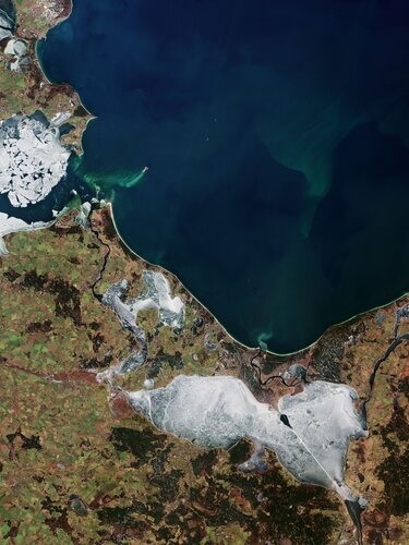
Part of Mecklenburg–West Pomerania, also known as Mecklenburg-Vorpommern, a state in northeast Germany is featured in this image captured by the Copernicus Sentinel-2 mission. A portion of the northwest coast of Poland can be seen in the right of the image.
EIVA releases entry-level hydrographic survey software variant
21.1.2022 9:00 GISCafe.com Webcasts-Webinars EIVA’s new software variant NaviSuite Kuda Core provides advanced hydrographic survey software capabilities at an entry-level price. Tailored …LiDAR Supercharges Vehicle Vision and the Transportation Transformation
21.1.2022 9:00 GISCafe.com Webcasts-Webinars NetworkNewsWire Editorial CoverageNEW YORK, Jan. 18, 2022 — (PRNewswire) — Buckle up because transportation is evolving double …
Interview with Alex Fox, Executive Vice President for Global Growth, HawkEye 360
21.1.2022 9:00 GISCafe.com Webcasts-WebinarsPřerušení dodávky elektrické energie
21.1.2022 8:45 ČÚZK /Urady/Katastralni-urady/Katastralni-urady/Katastralni-urad-pro-Zlinsky-kraj/Katastralni-pracoviste/KP-Val-Mezirici/Preruseni-dodavky-elektricke-energiePřerušení dodávky elektrické energie
21.1.2022 8:45 ČÚZK /Urady/Katastralni-urady/Katastralni-urady/Katastralni-urad-pro-Zlinsky-kraj/Katastralni-pracoviste/KP-Val-Mezirici/Uredni-deska/Oznameni-a-jina-uredni-sdeleni/Preruseni-dodavky-elektricke-energiePřerušení dodávky elektrické energie
21.1.2022 8:45 ČÚZK - předpisy a opatření Český úřad zeměměřický a katastrální - Katastrální pracoviště Valašské Meziříčí zveřejnil novou aktualitu: Katastrální úřad pro Zlínský kraj,Katastrální pracoviště Valašské Meziříčí
Katastrální úřad pro Zlínský kraj, Katastrální pracoviště Valašské Meziříčí (katastrální pracoviště) oznamuje, že dne 24.1.2022 od 7.30 hod – 13.30 hod, bude v souladu s ust. § 25 odst. 3 písm. c) bod 5 a písm. d), bod 6 zákona č. 458/2000 Sb., v platném znění, přerušena dodávka elektřiny - ČEZ Distribuce, a.s., z důvodu plánovaných prací na zařízení distribuční soustavy, a to v nezbytně nutném rozsahu.
Z výše uvedeného důvodu nebude možný provoz na katastrálním pracovišti.
Po uvedenou dobu bude možné pouze podávat písemná podání na podatelně, avšak nebude možné je dále zpracovávat, ani poskytovat výpisy z katastru nemovitostí nebo podávat informace o údajích katastru, a to ani ústně nebo nahlédnutím do katastru.
Přerušení dodávky elektrické energie
21.1.2022 8:45 ČÚZK - předpisy a opatření Český úřad zeměměřický a katastrální - Katastrální pracoviště Valašské Meziříčí zveřejnil novou aktualitu: Katastrální úřad pro Zlínský kraj,Katastrální pracoviště Valašské Meziříčí
Katastrální úřad pro Zlínský kraj, Katastrální pracoviště Valašské Meziříčí (katastrální pracoviště) oznamuje, že dne 24.1.2022 od 7.30 hod – 13.30 hod, bude v souladu s ust. § 25 odst. 3 písm. c) bod 5 a písm. d), bod 6 zákona č. 458/2000 Sb., v platném znění, přerušena dodávka elektřiny - ČEZ Distribuce, a.s., z důvodu plánovaných prací na zařízení distribuční soustavy, a to v nezbytně nutném rozsahu.
Z výše uvedeného důvodu nebude možný provoz na katastrálním pracovišti.
Po uvedenou dobu bude možné pouze podávat písemná podání na podatelně, avšak nebude možné je dále zpracovávat, ani poskytovat výpisy z katastru nemovitostí nebo podávat informace o údajích katastru, a to ani ústně nebo nahlédnutím do katastru.
PredaSAR, a Terran Orbital Corporation, Selected for National Reconnaissance Office (NRO) Geospatial Intelligence (GEOINT) Broad Agency Announcement (BAA) Award
20.1.2022 21:53 GISCafe.com Webcasts-Webinars BOCA RATON, Fla. — (BUSINESS WIRE) — January 20, 2022 —PredaSAR, a Terran Orbital Corporation, has been selected for contract …
EagleView Technologies, Inc. Promotes Patrick Gill to Chief Marketing Officer, Government Solutions
20.1.2022 21:53 GISCafe.com Webcasts-Webinars BELLEVUE, Wash., Jan. 20, 2022 (GLOBE NEWSWIRE) -- EagleView Technologies, Inc., a portfolio company of Vista Equity Partners and Clearlake …Reimagining Michael Baker International to Accelerate Growth and Innovation
20.1.2022 21:53 GISCafe.com Webcasts-Webinars Firm announces new organizational structure and enabling strategies to further broaden its capabilities, services and solutions to become a …Schneider Electric Introduces Infrastructure of the Future
20.1.2022 20:36 GISCafe.com Webcasts-Webinars RUEIL-MALMAISON, France, Jan. 20, 2022 — (PRNewswire) — Schneider Electric, the leader in the digital transformation of energy …Mapping the Future of Autonomous Vehicles Goes Right Through a SPAC
20.1.2022 20:36 GISCafe.com Webcasts-Webinars NetworkNewsWire Editorial CoverageNEW YORK, Jan. 20, 2022 — (PRNewswire) — Mainstream fully autonomous vehicles are not an if, they are …
The Peggy Smedley Show with Greg Bentley
20.1.2022 19:57 Bentley SystemsPressCoverage
Youtube.com
Read the articleVRMesh V11.6 Improves Workflow for Point Cloud Processing
20.1.2022 18:24 GISCafe.com Webcasts-Webinars Bellevue, WA. - Jan. 20, 2022 - VirtualGrid is pleased to announce the availability of VRMesh v11.6, the latest version of its powerful …Capella Space Awarded Commercial Radar Contract By National Reconnaissance Office
20.1.2022 18:09 GISCafe.com Webcasts-Webinars Capella will demonstrate high-resolution SAR imagery capabilities as part of the National Reconnaissance Office's Broad Agency Announcement Framework …Arsenal Completes Recapitalization of Headwall Photonics
20.1.2022 17:18 GISCafe.com Webcasts-Webinars Bolton, Massachusetts and New York, New York, Jan. 20, 2022 (GLOBE NEWSWIRE) -- Headwall Photonics (“Headwall“) today announced that it has …Viasat's New Large-Aperture Space-to-Ground Communication Antennas Ready to Support Lunar, Cislunar, Deep Space and DoD Missions
20.1.2022 17:18 GISCafe.com Webcasts-Webinars DULUTH, Ga., Jan. 20, 2022 — (PRNewswire) — Viasat Inc. (NASDAQ: VSAT), a global communications company, today announced the …USING DRONE LIDAR TO COMPLETE AN AS-BUILT SURVEY
20.1.2022 17:18 GISCafe.com Webcasts-Webinars Rome, NY, Jan. 20, 2022 (GLOBE NEWSWIRE) -- Traditionally, the documentation of As-Built construction surveys relied on conventional methods such …Luminar to Enable Enhanced Safety and Autonomy on Mercedes-Benz Passenger Cars
20.1.2022 17:18 GISCafe.com Webcasts-Webinars Luminar’s Iris lidar technology planned to be integrated into production vehicle platformORLANDO, Fla. — (BUSINESS WIRE) — January 20, …
Aktualizace dat v mapových aplikacích
20.1.2022 16:53 Jihočeský krajData katastru nemovitostí (DKM, KMD, KM-D) byla v mapových aplikacích a výdejním modulu aktualizována k 1.1.2022.
Symposium GIS Ostrava 16.–18. 3. 2022
20.1.2022 15:48 Česká kartografická společnost Dovolte nám, abychom vás informovali o prodloužení termínu přijímání příspěvků na Symposium GIS Ostrava 2022. Současně došlo k rozšíření nabídky workshopů. V rámci sympozia se konají konference: Smart City – vize a realita (přijímání referátů včetně abstraktů do 31. 1. 2022), Earth Observation for Smart City and Smart Region (přijímání rozšířených abstraktů do 31.1.2022) a studentská konference GISáček (přijímání příspěvků včetně abstraktů do 4. 3. […]Digital Built America Smarter More Sustainable and Resilient
20.1.2022 15:32 Bentley SystemsPressCoverage
ReliabilityWeb, USA
Read the articleRebuilding Infrastructure with Digital Twins Podcast
20.1.2022 15:16 Bentley SystemsPressCoverage
Peggy Smedley Show , USA
Read the articleVýběrové řízení
20.1.2022 13:28 ČÚZK - předpisy a opatření Katastrální úřad pro Liberecký kraj - Katastrální pracoviště Frýdlant zveřejnil novou aktualitu: Oznámení o vyhlášení výběrového řízení na obsazení služebního místa rada / odborný radav oddělení správy katastru nemovitostí - rozhodování o povolení vkladů
Výběrové řízení
20.1.2022 13:28 ČÚZK /Urady/Katastralni-urady/Katastralni-urady/Katastralni-urad-pro-Liberecky-kraj/Katastralni-pracoviste/KP-Frydlant/O-uradu/Aktuality/Vyberove-rizenirada / odborný rada v oddělení správy katastru nemovitostí
20.1.2022 13:21 ČÚZK /Urady/Katastralni-urady/Katastralni-urady/Katastralni-urad-pro-Liberecky-kraj/Uredni-deska/Oznameni-a-jina-uredni-sdeleni/Volna-mista/rada-odborny-rada-v-oddeleni-spravy-katastru-nemrada / odborný rada v oddělení správy katastru nemovitostí
20.1.2022 13:21 ČÚZK - předpisy a opatření Katastrální úřad pro Liberecký kraj - Katastrální pracoviště Frýdlantvypisuje výběrové řízení na místo
rada / odborný rada v oddělení správy katastru nemovitostí
rada / odborný rada v oddělení správy katastru nemovitostí
20.1.2022 13:21 ČÚZK - volná místa Katastrální úřad pro Liberecký kraj - Katastrální pracoviště Frýdlant vypisuje výběrové řízení na místo rada / odborný rada v oddělení správy katastru nemovitostíVR do 10.2
20.1.2022 13:02 ČÚZK - předpisy a opatření Katastrální úřad pro hlavní město Prahu - Katastrální pracoviště Praha zveřejnil novou aktualitu: Ředitelka úřadu vyhlašuje výběrová řízení na služební místa:* rada/odborný rada – obnova katastrálního operátu
VR do 10.2
20.1.2022 13:02 ČÚZK /Urady/Katastralni-urady/Katastralni-urady/Katastralni-urad-pro-hlavni-mesto-Prahu/O-uradu/Aktuality/VR-dorada/odborný rada – obnova katastrálního operátu
20.1.2022 13:00 ČÚZK - předpisy a opatření Katastrální úřad pro hlavní město Prahu Katastrální pracoviště Prahavypisuje výběrové řízení na místo
rada/odborný rada – obnova katastrálního operátu
rada/odborný rada – obnova katastrálního operátu
20.1.2022 13:00 ČÚZK /Urady/Katastralni-urady/Katastralni-urady/Katastralni-urad-pro-hlavni-mesto-Prahu/Uredni-deska/Oznameni-a-jina-uredni-sdeleni/Volna-mista/DMS/rada-odborny-rada-–-obnova-katastralniho-operaturada/odborný rada – obnova katastrálního operátu
20.1.2022 13:00 ČÚZK - volná místa Katastrální úřad pro hlavní město Prahu Katastrální pracoviště Praha vypisuje výběrové řízení na místo rada/odborný rada – obnova katastrálního operátuOmezení provozu 21.01.2022
20.1.2022 12:12 ČÚZK /Urady/Katastralni-urady/Katastralni-urady/Katastralni-urad-pro-Stredocesky-kraj/Katastralni-pracoviste/KP-Benesov/O-uradu/Aktuality/Omezeni-provozu-21-01-2022Omezení provozu 21.01.2022
20.1.2022 12:12 ČÚZK - předpisy a opatření Katastrální úřad pro Středočeský kraj - Katastrální pracoviště Benešov zveřejnil novou aktualitu: Z důvodu přerušení dodávky elektrické energoe bude katastrální pracoviště v pátek 21.1.2022 uzavřeno.Ve velmi omezené míře bude umožněn pouze příjem podání.
Za případné komplikace se omlouváme.
Sulphur dioxide from Tonga eruption spreads over Australia
20.1.2022 11:54 ESA Observing the Earth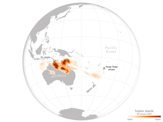 Image:
The Hunga-Tonga-Hunga-Ha'apai volcano near Tonga in the South Pacific erupted with such force on 15 January that it is thought to be the biggest eruption recorded anywhere on the planet in 30 years.
Image:
The Hunga-Tonga-Hunga-Ha'apai volcano near Tonga in the South Pacific erupted with such force on 15 January that it is thought to be the biggest eruption recorded anywhere on the planet in 30 years.
Sulphur dioxide from Tonga eruption spreads over Australia
20.1.2022 11:54 ESA Observing the Earth
Image:
Sulphur dioxide from Tonga eruption spreads over Australia
Výběrové řízení
20.1.2022 10:05 ČÚZK - předpisy a opatření Katastrální úřad pro Liberecký kraj - Katastrální pracoviště Jablonec nad Nisou zveřejnil novou aktualitu: Oznámení o vyhlášení výběrového řízení na obsazení služebního místa odborný referent v oddělení právních vztahů na KP Jablonec nad NisouMega iceberg released 152 billion tonnes of freshwater
20.1.2022 10:00 ESA Observing the Earth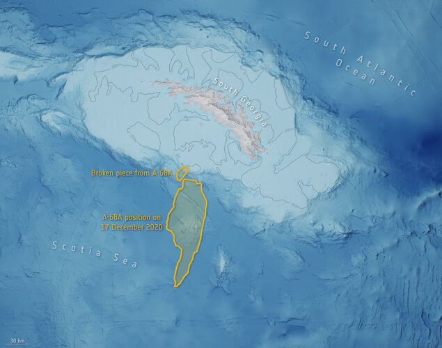
In July 2017, a giant iceberg, named A-68, snapped off Antarctica’s Larsen-C ice shelf and began an epic journey across the Southern Ocean. Three and a half years later, the main part of iceberg, A-68A, drifted worryingly close to South Georgia. Concerns were that the berg would run aground in the shallow waters offshore. This would not only cause damage to the seafloor ecosystem but also make it difficult for island wildlife, such as penguins, to make their way to the sea to feed. Using measurements from satellites, scientists have charted how A-68A shrunk towards the end of its voyage, which fortunately prevented it from getting stuck. However, the downside is that it released a colossal 152 billion tonnes of freshwater close to the island, potentially having a profound effect on the island’s marine life.
China Non-woven Bag Factory
20.1.2022 5:08 Siemens Industry SoftwareChina Non-woven Bag Factory China Non Woven Bags is a Leading Non Woven Bags manufacturer,...
The post China Non-woven Bag Factory appeared first on Siemens Blogs.
China Non-woven Bag Factory
20.1.2022 5:08 Siemens Industry SoftwareChina Non-woven Bag Factory China Non Woven Bags is a Leading Non Woven Bags manufacturer,...
The post China Non-woven Bag Factory appeared first on Siemens Blog Network.
China Non-woven Bag Factory
20.1.2022 5:08 Siemens Industry SoftwareChina Non-woven Bag Factory China Non Woven Bags is a Leading Non Woven Bags manufacturer,...
The post China Non-woven Bag Factory appeared first on Clipping Path Center Inc.
Státní pozemkový úřad v roce 2021 vynaložil 2,965 miliard Kč na pozemkové úpravy
20.1.2022 0:00 Státní pozemkový úřad Praha, 20. ledna 2022 - Státní pozemkový úřad (SPÚ) vynaložil v roce 2021 na pozemkové úpravy finanční prostředky v celkové výši 2,965 miliard Kč, což je historicky nejvyšší částka, s kterou kdy SPÚ operoval.GISCI Announces Retired Designation Policy (GISP-R) for Retired GISPs
19.1.2022 23:39 GISCafe.com Webcasts-Webinars Retired GISPs may apply now to receive the designation. GISCI Announces Retired Designation Policy (GISP-R)Des Plaines, IL (January 19, 2022) -The …
The International Space Station connected via the SpaceDataHighway
19.1.2022 22:03 GISCafe.com Webcasts-Webinars Munich, 17 January 2022 – The Airbus’ SpaceDataHighway – developed with the support of ESA – provides broadband connectivity …A challenge for the future
19.1.2022 18:25 Bentley SystemsPressCoverage
CAD User, UK&I
Read the article22 digital twins trends that will shape 2022
19.1.2022 18:17 Bentley SystemsPressCoverage
Venture Beat, USA
Read the articleM A Powering Up The 3 Types of Deals In The New Energy Economy
19.1.2022 18:07 Bentley SystemsPressCoverage
Forbes, USA
Read the articleGoAigua and WatSyn Solutions Join Forces to Help Canadian Water and Wastewater Utilities Unify Digital Infrastructure
19.1.2022 18:04 GISCafe.com Webcasts-Webinars WatSyn’s utility support services combined with GoAigua’s smart water platform will simplify digital transformation, reduce non-revenue water, …HawkEye360 to Deliver Large Data Files Over LEO Satellites using BitRipple Technology
19.1.2022 18:04 GISCafe.com Webcasts-Webinars BitRipple's Liquid Networking™ technology enables secure, efficient delivery with no backchannelBERKELEY, Calif., Jan. 19, 2022 — …
Treated Water Supply Management in Urban Areas
19.1.2022 17:40 Bentley SystemsPressCoverage
Water Today, India
Read the articleExclusive Interview with Mr Siddhartha Chatterjee
19.1.2022 17:32 Bentley SystemsPressCoverage
Rail Analysis, India
Read the articleOil and Gas News Middle East
19.1.2022 17:24 Bentley SystemsPressCoverage
Oil and Gas News, Middle East
Read the articleReality Now Turning Data into Actionable Information
19.1.2022 17:12 Bentley SystemsPressCoverage
Informed Infrastructure, USA
Read the articleGrowth Capital Acquisition Corp. (NASDAQ: GCAC), Cepton Technologies Partner in Upcoming Lidar SPAC Merger
19.1.2022 16:13 GISCafe.com Webcasts-Webinars NEW YORK, Jan. 19, 2022 (GLOBE NEWSWIRE) -- via InvestorWire — Growth Capital Acquisition Corp. (NASDAQ: GCAC) today announces its placement in …Dynam.AI Unveils Vizlab, a Next-Generation AI Platform with Customizable Real-World Machine Learning Capabilities
19.1.2022 16:13 GISCafe.com Webcasts-Webinars Data scientists are encouraged to join the early access waitlist at Vizlab.AI and request a demo.SAN DIEGO, Calif., Jan. 19, 2022 — …
Výběrové řízení -poskytování informací KN PIKN1301- Rokycany
19.1.2022 11:45 ČÚZK /Urady/Katastralni-urady/Katastralni-urady/Katastralni-urad-pro-Plzensky-kraj/O-uradu/Aktuality/Vyberove-rizeni-poskytovani-informaci-KN-PIKN1301Výběrové řízení -poskytování informací KN PIKN1301- Rokycany
19.1.2022 11:45 ČÚZK - předpisy a opatření Zeměměřický a katastrální inspektorát v Plzni - Katastrální pracoviště Rokycany zveřejnil novou aktualitu: Výběrové řízení na služební místo odborný/vrchní referent – poskytování informací KN PIKN1301, oddělení aktualizace a dokumentace KN, KP RokycanyVýběrové řízení na služební místo odborný/vrchní referent – poskytování informací KN PIKN1301, odděl
19.1.2022 11:35 ČÚZK - volná místa Katastrální úřad pro Plzeňský kraj Katastrální pracoviště Rokycany vypisuje výběrové řízení na místo Výběrové řízení na služební místo odborný/vrchní referent – poskytování informací KN PIKN1301, oddělVýběrové řízení na služební místo odborný/vrchní referent – poskytování informací KN PIKN1301, odděl
19.1.2022 11:35 ČÚZK - předpisy a opatření Katastrální úřad pro Plzeňský kraj Katastrální pracoviště Rokycanyvypisuje výběrové řízení na místo
Výběrové řízení na služební místo odborný/vrchní referent – poskytování informací KN PIKN1301, oddělení aktualizace a dokumentace KN, KP Rokycany
Výběrové řízení na služební místo odborný/vrchní referent – poskytování informací KN PIKN1301, odděl
19.1.2022 11:35 ČÚZK /Urady/Katastralni-urady/Katastralni-urady/Katastralni-urad-pro-Plzensky-kraj/Uredni-deska/Oznameni-a-jina-uredni-sdeleni/Volna-mista/DMS/Vyberove-rizeni-na-sluzebni-misto-odborny-vrchni-rZveřejnění obsahu informací poskytnutých na žádost dle zákona č. 106/1999 Sb. za rok 2022
19.1.2022 11:18 ČÚZK - předpisy a opatření Zeměměřický a katastrální inspektorát v Prazezveřejňuje obsah informace poskytnutých na žádost dle zákona č. 106/1999 Sb. za rok 2022
2022
Zveřejnění obsahu informací poskytnutých na žádost dle zákona č. 106/1999 Sb. za rok 2022
19.1.2022 11:18 ČÚZK /Urady/Zememericke-a-katastralni-inspektoraty/Zememericke-a-katastralni-inspektoraty/Zememericky-a-katastralni-inspektorat-v-Praze/Casto-hledane-informace/Poskytovani-informaci-106-1999-Sb/Zverejneni-obsahu-informaci-poskytnutych-na-za-(1)/Zverejneni-obsahu-informaci-poskytnutych-na-za-(4)Výroční zpráva dle zákona č. 106/1999 Sb. za rok 2021
19.1.2022 10:56 ČÚZK - předpisy a opatření Zeměměřický a katastrální inspektorát v Prazevydává výroční zprávu úřadu za rok 2021
2021
Výroční zpráva dle zákona č. 106/1999 Sb. za rok 2021
19.1.2022 10:56 ČÚZK /Urady/Zememericke-a-katastralni-inspektoraty/Zememericke-a-katastralni-inspektoraty/Zememericky-a-katastralni-inspektorat-v-Praze/Vyrocni-zpravy/Vyrocni-zprava-dle-zakona-c-106-1999-Sb-za-rok-(4)Obhajoba dizertační práce Mgr. Martina Erlebacha
19.1.2022 0:00 Geografický ústav MUVe středu 19. 1. 2022 od 10 hod se uskuteční obhajoba dizertační práce Mgr. Martina Erlebacha s názvem LOKÁLNÍ TRHY PRÁCE ČESKÉ REPUBLIKY, školitel doc. Václav Toušek.
Místo a forma bude upřesněna podle aktuální všeobecné epidemické situace a možností zainteresovaných, a to buď v mapovně prezenčně nebo v Z4 online resp. hybridně.
Práce je přístupná na https://is.muni.cz/auth/th/sgby2/.
Obhajoba dizertační práce Mgr. Martina Erlebacha
19.1.2022 0:00 Geografický ústav MUVe středu 19. 1. 2022 od 10 hod se uskuteční obhajoba dizertační práce Mgr. Martina Erlebacha s názvem LOKÁLNÍ TRHY PRÁCE ČESKÉ REPUBLIKY, školitel doc. Václav Toušek.
Místo a forma bude upřesněna podle aktuální všeobecné epidemické situace a možností zainteresovaných, a to buď v mapovně prezenčně nebo v Z4 online resp. hybridně.
Práce je přístupná na https://is.muni.cz/auth/th/sgby2/.
Terradepth Expands Leadership Team to Attain 2022 Ocean-Mapping Milestones
18.1.2022 17:03 GISCafe.com Webcasts-Webinars End-to-end ocean-data system startup names first chief operating officer among other executivesPotential customers include companies in the …
Deepspatial Inc. Provides Corporate Update and Highlights Key Milestones Anticipated in 2022
18.1.2022 17:03 GISCafe.com Webcasts-Webinars TORONTO — (BUSINESS WIRE) — January 18, 2022 —Deepspatial Inc. (CSE:DSAI) (OTCQB:DSAIF) (“Deepspatial” or the “Company”), …