


![]()

zprávy
zdroje zpráv:Přerušení provozu DP a WSDP ve čtvrtek 3.2.2022 od 16:30 do cca 20:30.
28.1.2022 14:06 Dálkový přístup k údajům KN ČR Vážení uživatelé,oznamujeme, že ve čtvrtek 3.2.2022 bude od 16:30 z provozních důvodů zcela přerušen provoz Dálkového přístupu i Webových služeb dálkového přístupu. Obnovení provozu předpokládáme do cca 20:30 hodin. Instalace oprav nemá dopad na funkčnost webových služeb.
Součástí instalace jsou i změny XSD pro sestavy „Informace o parcelách“ a „Přehled vlastnictví s nemovitostmi“. Informace o aktualizaci dokumentace byla vystavena 22.12.2021.
https://www.cuzk.cz/Aplikace-DP-do-KN/Aplikace-DP-do-KN/Archiv-DP/342545.aspx
Za komplikace tímto způsobené se omlouváme a děkujeme za pochopení.
Přerušení provozu DP a WSDP ve čtvrtek 3.2.2022 od 16:30 do cca 20:30.
28.1.2022 14:06 ČÚZK /Aplikace-DP-do-KN/Aplikace-DP-do-KN/Archiv-DP/346153Přerušení provozu DP a WSDP ve čtvrtek 3.2.2022 od 16:30 do cca 20:30.
28.1.2022 14:06 ČÚZK - předpisy a opatření Vážení uživatelé,oznamujeme, že ve čtvrtek 3.2.2022 bude od 16:30 z provozních důvodů zcela přerušen provoz Dálkového přístupu i Webových služeb dálkového přístupu. Obnovení provozu předpokládáme do cca 20:30 hodin. Instalace oprav nemá dopad na funkčnost webových služeb.
Součástí instalace jsou i změny XSD pro sestavy „Informace o parcelách“ a „Přehled vlastnictví s nemovitostmi“. Informace o aktualizaci dokumentace byla vystavena 22.12.2021.
https://www.cuzk.cz/Aplikace-DP-do-KN/Aplikace-DP-do-KN/Archiv-DP/342545.aspx
Za komplikace tímto způsobené se omlouváme a děkujeme za pochopení.
Earth from Space: Lesotho
28.1.2022 10:00 ESA Observing the Earth
The Copernicus Sentinel-2 mission takes us over northwest Lesotho – a small, land-locked country surrounded entirely by South Africa.
2022 URISA Exemplary Systems in Government Awards Process Opens
28.1.2022 9:00 GISCafe.com Webcasts-Webinars Des Plaines, IL (January 26, 2022) URISA is pleased to announce the Exemplary Systems in Government (ESIG) Awards process for 2022. Since 1980, …French General Directorate Cadastral Bureau joins EuroGeographics
28.1.2022 9:00 GISCafe.com Webcasts-Webinars EuroGeographics has welcomed the French General Directorate Cadastral Bureau as an Associate Member.The Bureau’s membership of …
"GISCafe Voice Industry Predictions for 2022 – Part 2" by Susan Smith
28.1.2022 8:28 GISCafe.com Webcasts-WebinarsOneSky Wins Contract to Develop Australia's UTM Framework: Airservices' FIMS Project
27.1.2022 23:00 GISCafe.com Webcasts-Webinars Global UTM services provider OneSky awarded a contract with Airservices Australia (Airservices) to develop a working prototype of a Flight …Konferencia GeoKARTO 2022 v termíne 8.–9. 9. 2022
27.1.2022 19:42 Česká kartografická společnost Konferencia je organizovaná každé dva roky Kartografickou spoločnosťou SR v spolupráci s významnými akademickými inštitúciami so zameraním na aktuálne otázky a trendy teórie a praxe kartografie, geoinformatiky a geodézie. V roku 2022 sa bude konferencia organizovať v spolupráci s Katedrou fyzickej geografie a geoinformatiky, Prírodovedeckej fakulty UK v Bratislave. Více informací na webových stránkách konference. Miesto konania: Prírodovedecká fakulta Univerzity Komenského v Bratislave […]Optelos and Flyguys Partner to Enhance Nationwide Turnkey Drone Data Collection and Visual Asset Inspection Capability
27.1.2022 19:12 GISCafe.com Webcasts-Webinars Partnership combines Flyguys nationwide network of drone data collection services with Optelos' visual data management and analytics platform to …Urban SDK Increases Seed Funding to $4.5 Million, Continues Nationwide Expansion
27.1.2022 19:12 GISCafe.com Webcasts-Webinars JACKSONVILLE, Fla., Jan. 27, 2022 (GLOBE NEWSWIRE) -- GIS data and analytics software company Urban SDK announces that it has raised an …TurboCAD MAC Deluxe 12 CZ v akční ceně
27.1.2022 17:27 ŠPINAR - softwareVážení zákazníci, dovolujeme si Vám nabídnout program TurboCAD MAC Deluxe pro 2D a 3D kreslení v češtině. v akční ceně do 5.2.2022.
The post TurboCAD MAC Deluxe 12 CZ v akční ceně appeared first on ŠPINAR – software.
TurboCAD MAC Deluxe 12 CZ v akční ceně
27.1.2022 17:27 ŠPINAR - software Vážení zákazníci, dovolujeme si Vám nabídnout program TurboCAD MAC Deluxe pro 2D a 3D kreslení v češtině. v akční ceně do 5.2.2022.Teledyne Technologies Reports Fourth Quarter Results
27.1.2022 16:32 GISCafe.com Webcasts-Webinars THOUSAND OAKS, Calif. — (BUSINESS WIRE) — January 27, 2022 —Teledyne Technologies Incorporated (NYSE:TDY)
Record quarterly …
Textron Reports Fourth Quarter 2021 Results; Announces 2022 Financial Outlook
27.1.2022 16:32 GISCafe.com Webcasts-Webinars Fourth Quarter EPS from continuing operations of $0.93; Adjusted EPS of $0.94Aviation backlog $4.1 billion at year-end, up $655 million in the …
Kratos Releases Earth Observation & Remote Sensing Service Chain Enhancements for its OpenSpace Platform
27.1.2022 16:32 GISCafe.com Webcasts-Webinars SAN DIEGO, Jan. 27, 2022 (GLOBE NEWSWIRE) -- Kratos Defense & Security Solutions, Inc. (Nasdaq: KTOS), a leading National Security Solutions …Geosapiens receives funding from the Canadian Space Agency to optimize flood management
27.1.2022 16:32 GISCafe.com Webcasts-Webinars QUÉBEC CITY, Jan. 27, 2022 — (PRNewswire) —This major funding contribution will enable the development of innovative approaches to …
Permafrost thaw: it’s complicated
27.1.2022 16:00 ESA Observing the Earth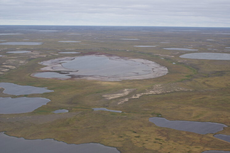
One of the many serious consequences of the climate crisis is that precious permafrost is thawing, and this is unleashing even more carbon to the atmosphere and further exacerbating climate change. However, it’s complicated. For example, sometimes permafrost can thaw rapidly and scientists are unsure why and what these abrupt thaws mean in terms of feedback loops. This makes it difficult to predict the future impact on the climate. Thanks to an ESA–NASA initiative, new research digs deep into understanding the complexities of permafrost thaw and how carbon is released over time.
Mapová aplikace ÚPD - nové dokumentace
27.1.2022 14:54 Jihočeský krajV mapové aplikaci Územně plánovací dokumentace obcí byla aktualizována ÚPD obcí ORP Jindřichův Hradec - Březina, Kamenný Malíkov, Plavsko, ORP Český Krumlov – Polná na Šumavě, Věžovatá Pláně a ORP Kaplice – Besednice.
Odborný rada - vedoucí oddělení metodiky, kontroly a personalistiky kanceláře ředitele Katastrálního
27.1.2022 13:32 ČÚZK /Urady/Katastralni-urady/Katastralni-urady/Katastralni-urad-pro-Kralovehradecky-kraj/Uredni-deska/Oznameni-a-jina-uredni-sdeleni/Volna-mista/DMS/Odborny-rada-vedouci-oddeleni-metodiky,-kontrolyOdborný rada - vedoucí oddělení metodiky, kontroly a personalistiky kanceláře ředitele Katastrálního
27.1.2022 13:32 ČÚZK - volná místa Katastrální úřad pro Královéhradecký kraj kancelář ředitele vypisuje výběrové řízení na místo Odborný rada - vedoucí oddělení metodiky, kontroly a personalistiky kanceláře ředitele KatastrálníhoOdborný rada - vedoucí oddělení metodiky, kontroly a personalistiky kanceláře ředitele Katastrálního
27.1.2022 13:32 ČÚZK - předpisy a opatření Katastrální úřad pro Královéhradecký kraj kancelář ředitelevypisuje výběrové řízení na místo
Odborný rada - vedoucí oddělení metodiky, kontroly a personalistiky kanceláře ředitele Katastrálního úřadu pro Královéhradecký kraj
20220127 - volné místo - Rada/odborný rada v OMaK kanceláře ředitele KÚ na KÚ pro Ústecký kraj
27.1.2022 10:58 ČÚZK /Urady/Katastralni-urady/Katastralni-urady/Katastralni-urad-pro-Ustecky-kraj/O-uradu/Aktuality/20220127-volne-misto-Rada-odborny-rada-v OMaK20220127 - volné místo - Rada/odborný rada v OMaK kanceláře ředitele KÚ na KÚ pro Ústecký kraj
27.1.2022 10:58 ČÚZK - předpisy a opatření Katastrální úřad pro Ústecký kraj zveřejnil novou aktualitu: Nabídka volného místa - Rada / odborný rada v oddělení metodiky a kontroly kanceláře ředitele katastrálního úřadu na Katastrálním úřadu pro Ústecký kraj20220127 - volné místo - Vedoucí OOKO I. v TO na Katastrálním úřadu pro Ústecký kraj
27.1.2022 10:33 ČÚZK - předpisy a opatření Katastrální úřad pro Ústecký kraj zveřejnil novou aktualitu: Nabídka volného místa - služební místo představeného - Vedoucí oddělení obnovy katastrálního operátu I. v technickém odboru na Katastrálním úřadu pro Ústecký kraj20220127 - volné místo - Vedoucí OOKO I. v TO na Katastrálním úřadu pro Ústecký kraj
27.1.2022 10:33 ČÚZK /Urady/Katastralni-urady/Katastralni-urady/Katastralni-urad-pro-Ustecky-kraj/O-uradu/Aktuality/20220127-volne-misto-Vedouci-OOKO-I-v TO-na-KZemřel RNDr. Tomáš Grim, Ph.D. (1949-2022) [Knihovna geografie, byTopic]
27.1.2022 0:00 Katedra aplikované geoinformatiky a kartografie Přf UK Smutná zpráva obletěla nejen českou kartografickou komunitu – minulý pátek (21.1.2022) nás opustil ve věku nedožitých 73 let významný historický kartograf a geograf, RNDr. Tomáš Grim, Ph.D.Historic Minneapolis Stone Arch Bridge Gets Repaired
26.1.2022 20:25 Bentley SystemsPressCoverage
Engineering.com, USA
Read the articleDigital Built America Smarter More Sustainable and Resilient
26.1.2022 20:19 Bentley SystemsPressCoverage
Reliability Web, USA
Read the articleWe have already entered a new era when it comes to the water industry
26.1.2022 20:12 Bentley SystemsPressCoverage
Smart Water Magazine, Southern Europe
Read the articleBentleys WaterGems and StaadPro helped us to efficiently design the water supply scheme
26.1.2022 20:00 Bentley SystemsPressCoverage
Smart Water Magazine, Southern Europe
Read the articleTopcon Announces GTL-1200 Scanning Robotic Total Station
26.1.2022 19:56 GISCafe.com Webcasts-Webinars LIVERMORE, Calif. — (BUSINESS WIRE) — January 25, 2022 —Topcon Positioning Group has announced its latest scanning robotic total …
Elroy Air Unveils Its Chaparral, a First-of-its-kind, Autonomous, Hybrid-electric VTOL Cargo Aircraft
26.1.2022 19:56 GISCafe.com Webcasts-Webinars Company announces commitments for more than 500 aircraft representing more than $1 billion in aircraft demand from commercial, defense, and …North Wales Police to deploy Hexagon’s cloud-based, next-generation dispatch system
26.1.2022 19:28 Hexagon Safety & Infrastructure Advanced capabilities will expand communication channels, improve response and optimize resourcesCelostátní sčítání dopravy CSD 2020
26.1.2022 18:05 GeoBusinessCSD 2020 bylo zajišťováno, stejně jako při minulém sčítání, vybraným dodavatelem, jímž bylo tentokrát sdružení firem CDVAMP (Centrum dopravního výzkumu, v. v. i., ManpowerGroup s.r.o. a VARS BRNO, a.s.) pod vedením Centra dopravního výzkumu v. v. i. Celková cena služeb, které byly nebo budou v zakázce poskytnuty, dosahuje necelých 52 mil. Kč bez DPH. Spolupráce […]
The post Celostátní sčítání dopravy CSD 2020 appeared first on GeoBusiness.
Celostátní sčítání dopravy CSD 2020
26.1.2022 18:05 GeoBusiness CSD 2020 bylo zajišťováno, stejně jako při minulém sčítání, vybraným dodavatelem, jímž bylo tentokrát sdružení firem CDVAMP (Centrum dopravního výzkumu, v. v. i., ManpowerGroup s.r.o. a VARS BRNO, a.s.) pod vedením Centra dopravního výzkumu v. v. i. Celková cena služeb, které byly nebo budou v zakázce poskytnuty, dosahuje necelých 52 mil. Kč bez DPH. Spolupráce […]Celostátní sčítání dopravy CSD 2020
26.1.2022 18:05 GeoBusiness CSD 2020 bylo zajišťováno, stejně jako při minulém sčítání, vybraným dodavatelem, jímž bylo tentokrát sdružení firem CDVAMP (Centrum dopravního výzkumu, v. v. i., ManpowerGroup s.r.o. a VARS BRNO, a.s.) pod vedením Centra dopravního výzkumu v. v. i. Celková cena služeb, které byly nebo budou v zakázce poskytnuty, dosahuje necelých 52 mil. Kč bez DPH. Spolupráce s dodavatelem probíhala i přes […]Celostátní sčítání dopravy CSD 2020
26.1.2022 18:05 GeoBusinessCSD 2020 bylo zajišťováno, stejně jako při minulém sčítání, vybraným dodavatelem, jímž bylo tentokrát sdružení firem CDVAMP (Centrum dopravního výzkumu, v. v. i., ManpowerGroup s.r.o. a VARS BRNO, a.s.) pod vedením Centra dopravního výzkumu v. v. i. Celková cena služeb, které byly nebo budou v zakázce poskytnuty, dosahuje necelých 52 mil. Kč bez DPH. Spolupráce s dodavatelem probíhala i přes […]
The post Celostátní sčítání dopravy CSD 2020 appeared first on GeoBusiness.
Chevron Places Order for American Robotics’ Automated Drones
26.1.2022 17:07 GISCafe.com Webcasts-Webinars American Robotics builds its customer base in the oil and gas sector with new purchase orderWALTHAM, Mass. — (BUSINESS WIRE) — January …
Skyway and TruWeather Announce Strategic Partnership
26.1.2022 17:07 GISCafe.com Webcasts-Webinars SAN RAFAEL, Calif., Jan. 26, 2022 (GLOBE NEWSWIRE) -- Skyway Technologies Corp. is excited to announce TruWeather Solutions as their newest …RTK From the Sky™ technology transforms Hexagon | NovAtel TerraStar-C PRO service with three minute global convergence
26.1.2022 17:07 GISCafe.com Webcasts-Webinars TerraStar-C PRO is the first global correction service from Hexagon to incorporate innovative RTK From the Sky technology to achieve RTK-level …Canadian Coast Guard Conducts Offshore Sea Trials of VTOL UAS with Shield AI and Kongsberg Geospatial
26.1.2022 17:07 GISCafe.com Webcasts-Webinars BVLOS endurance and Intelligence gathering trials of the V-BAT UAS were conducted in a variety of sea states and weather conditionsOTTAWA, Ontario, …
Droneshield Releases Upgraded Capabilities Via Firmware Across Its C-UAS Devices For Quicker And More Effective Detection
26.1.2022 17:07 GISCafe.com Webcasts-Webinars Global Leader in Drone Defense Tech / Counter-UAS, Electronic Warfare and Signals Intelligence Shares Details on Next-Level RfPatrolTM, RfOneTM and …Intermap's U.S. Insurance Solution Expands into Pricing Flood Premiums with Top-5 Underwriter
26.1.2022 17:07 GISCafe.com Webcasts-Webinars DENVER, Jan. 26, 2022 — (PRNewswire) — Intermap Technologies (TSX: IMP) (OTCQX: ITMSF) ("Intermap" or the "Company"), a global leader in …Tantek 4D successfully manages construction of tallest modular built high rise in the world
26.1.2022 16:57 Bentley SystemsPressCoverage
The Big Project Middle East, Middle East
Read the articleAthens under snow
26.1.2022 16:00 ESA Observing the Earth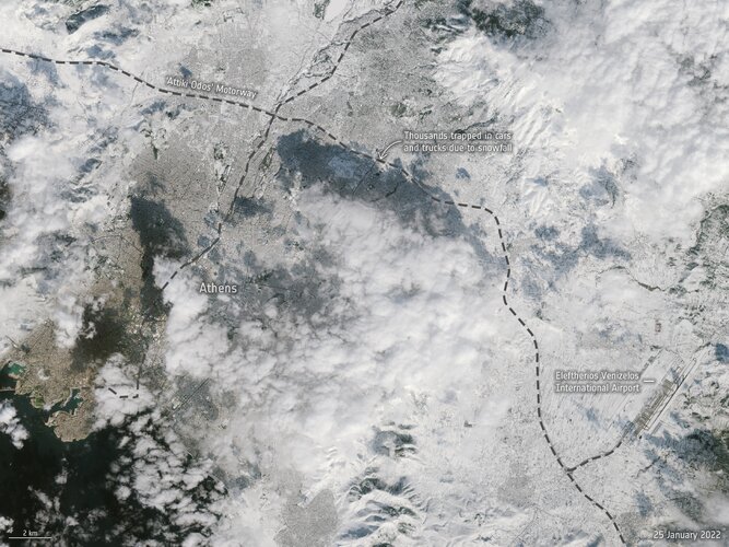 Image:
An unusual snowstorm has blanketed parts of Turkey and Greece, causing power cuts and chaos on the roads and flight cancellations. Two images from Copernicus Sentinel-2 show Athens before and after the snowstorm.
Image:
An unusual snowstorm has blanketed parts of Turkey and Greece, causing power cuts and chaos on the roads and flight cancellations. Two images from Copernicus Sentinel-2 show Athens before and after the snowstorm.
Athens under snow
26.1.2022 16:00 ESA Observing the Earth
Image:
An unusual snowstorm has blanketed parts of Turkey and Greece, causing power cuts and chaos on the roads and flight cancellations. Two images from Copernicus Sentinel-2 show Athens:before and after the snowstorm.
Porucha telefonní ústředny
26.1.2022 15:09 ČÚZK - předpisy a opatření Katastrální úřad pro Olomoucký kraj - Katastrální pracoviště Olomouc zveřejnil novou aktualitu: Telefonní spojení na Katastrální pracoviště Olomoucje momentálně nedostupné z důvodu poruchy telefonní ústředny.
Na odstranění poruchy se pracuje.
Děkujeme za pochopení.
Porucha telefonní ústředny
26.1.2022 15:09 ČÚZK - předpisy a opatření Katastrální úřad pro Olomoucký kraj - Katastrální pracoviště Olomouc zveřejnil novou aktualitu: Telefonní spojení na Katastrální úřad pro Olomoucký kraj a na Katastrální pracoviště Olomoucje momentálně nedostupné z důvodu poruchy telefonní ústředny.
Na odstranění poruchy se pracuje.
Děkujeme za pochopení.
Porucha telefonní ústředny
26.1.2022 15:09 ČÚZK /Urady/Katastralni-urady/Katastralni-urady/Katastralni-urad-pro-Olomoucky-kraj/O-uradu/Aktuality/Porucha-telefonni-ustrednyOpustil nás čestný člen ČKS RNDr. Tomáš Grim, Ph.D.
26.1.2022 14:35 Česká kartografická společnost Velmi smutná zpráva nejen pro českou kartografickou komunitu. RNDr. Tomáš Grim, Ph.D., který se teprve v loňském roce stal čestným členem ČKS, nás náhle opustil. Čest jeho památce. Pohřeb se uskuteční v pátek 28. ledna 2022 od 14 hodin v kostele sv. Petra a Pavla v Hradci nad Moravicí.20220126 - VŘ Administrace systémového managementu
26.1.2022 14:29 ČÚZK /Aktuality-resort/2022/20220126-VR-Administrace-systemoveho-managementu20220126 - VŘ Administrace systémového managementu
26.1.2022 14:29 ČÚZK - předpisy a opatření Český úřad zeměměřický a katastrální zveřejnil novou aktualitu: Oznámení o vyhlášení výběrového řízení na obsazení služebního místa rada/odborný rada - Administrace systémového managementu.20220126 - VŘ Administrace systémového managementu
26.1.2022 14:29 ČÚZK - aktuality v resortu Oznámení o vyhlášení výběrového řízení na obsazení služebního místa rada/odborný rada - Administrace systémového managementu.MawisPhoto vyhrálo 3. místo
26.1.2022 13:38 Hrdlička V soutěži Egovernment The Best 2021 jsme obsadili třetí příčku.The EUSPA EO and GNSS Market Report is out! Did you get your copy?
26.1.2022 13:20 European GNSS Agency
To help you better appreciate and reap the full benefits of space technology, EUSPA experts compiled the "EUSPA EO and GNSS Market Report". The 216-page long release is the ultimate guide to anyone who seeks to make the EU Space technologies part of their business plan, develop new space downstream applications and see a tangible return on investment.
More than ever society relies on innovative solutions to deal with the big data paradigm, respond to and mitigate climate change, natural and man-made disasters, curb the spread of diseases and strengthen a global supply chain that underpins our daily lives. Earth Observation (EO) and Global Navigation Satellite System (GNSS) data is becoming increasingly important to these innovative solutions through dozens of applications that are emerging or already in use by citizens, businesses, governments, industry, international organizations, NGOs, and researchers around the world. In 2021, GNSS and EO downstream market generated over 200 billion euros revenues and are set to reach almost half a trillion over the next decade.
The report provides analytical information on the dynamic GNSS and EO markets. It also offers in-depth analyses of the latest global trends and developments through illustrated examples and use cases. Using advanced econometric models, it also offers market evolution forecasts of GNSS shipments or EO revenues spanning to 2031.
Who is it for?
Practically, the report is useful to anyone who seeks to include GNSS or EO data in their operations to bring added value to their business. It is meant for businesses, entrepreneurs, innovators, academia, chipset manufacturers, researchers, and more. If you are looking to break through into the space downstream industry, this report is the ultimate guide, offering great insights on market trends as well as future forecasts.
Eyes on Sustainability
Accelerating Europe’s engagement in space is pivotal to enable our green transition and reach climate neutrality by 2050. EUSPA is committed to helping the Union deliver on the Green Deal agenda, and the fight against climate change starting with embedding space data and services into our professional activities.
The report emphasises how the user of EO & GNSS contribute to compliance, monitoring, and efficiency of green investments, benefitting companies, regulators, and society as a whole. It focuses on concrete examples across the 17 identified market segments. For instance, in the area of green energy, EU Space plays a role too! Copernicus helps optimize the performance of tidal power generators, by offering data on the rise and fall tides through tidal currents prediction systems. Galileo can provide smart power grids with robust timing and synchronization down to a nanosecond level and therefore improve their performance.
Key Report findings:
- Global GNSS and EO enabled revenues crossed 200 billion in 2021 set to reach almost 500 billion over the next decade;
- The global installed base of GNSS devices in use will reach more than 10 bn units in 2031;
- The market for Earth Observation applications is boosted by a large pool of value-added services (i.e. 85% of global revenue);
- The European EO industry is dominated by SMEs and start-ups, from a supply perspective, European companies hold over 41% of the global EO market.
- The downstream space application market accompanied by the EU Space Programme will continue growing and thereby effectively contributing to European (e.g. European Green Deal, EU's Digital Decade), as well as Global policies (e.g. United Nation’s Sustainable Development Goals and the Paris Agreement) in combination with other technologies.
You can download the 2022 Market Report here.
The EUSPA EO and GNSS Market Report is out! Did you get your copy?
26.1.2022 13:20 European GNSS Agency
To help you better appreciate and reap the full benefits of space technology, EUSPA experts compiled the "EUSPA EO and GNSS Market Report". The 216-page long release is the ultimate guide to anyone who seeks to make the EU Space technologies part of their business plan, develop new space downstream applications and see a tangible return on investment.
More than ever society relies on innovative solutions to deal with the big data paradigm, respond to and mitigate climate change, natural and man-made disasters, curb the spread of diseases and strengthen a global supply chain that underpins our daily lives. Earth Observation (EO) and Global Navigation Satellite System (GNSS) data is becoming increasingly important to these innovative solutions through dozens of applications that are emerging or already in use by citizens, businesses, governments, industry, international organizations, NGOs, and researchers around the world. In 2021, GNSS and EO downstream market generated over 200 billion euros revenues and are set to reach almost half a trillion over the next decade.
The report provides analytical information on the dynamic GNSS and EO markets. It also offers in-depth analyses of the latest global trends and developments through illustrated examples and use cases. Using advanced econometric models, it also offers market evolution forecasts of GNSS shipments or EO revenues spanning to 2031.
Who is it for?
Practically, the report is useful to anyone who seeks to include GNSS or EO data in their operations to bring added value to their business. It is meant for businesses, entrepreneurs, innovators, academia, chipset manufacturers, researchers, and more. If you are looking to break through into the space downstream industry, this report is the ultimate guide, offering great insights on market trends as well as future forecasts.
Eyes on Sustainability
Accelerating Europe’s engagement in space is pivotal to enable our green transition and reach climate neutrality by 2050. EUSPA is committed to helping the Union deliver on the Green Deal agenda, and the fight against climate change starting with embedding space data and services into our professional activities.
The report emphasises how the user of EO & GNSS contribute to compliance, monitoring, and efficiency of green investments, benefitting companies, regulators, and society as a whole. It focuses on concrete examples across the 17 identified market segments. For instance, in the area of green energy, EU Space plays a role too! Copernicus helps optimize the performance of tidal power generators, by offering data on the rise and fall tides through tidal currents prediction systems. Galileo can provide smart power grids with robust timing and synchronization down to a nanosecond level and therefore improve their performance.
Key Report findings:
- Global GNSS and EO enabled revenues crossed 200 billion in 2021 set to reach almost 500 billion over the next decade;
- The global installed base of GNSS devices in use will reach more than 10 bn units in 2031;
- The market for Earth Observation applications is boosted by a large pool of value-added services (i.e. 85% of global revenue);
- The European EO industry is dominated by SMEs and start-ups, from a supply perspective, European companies hold over 41% of the global EO market.
- The downstream space application market accompanied by the EU Space Programme will continue growing and thereby effectively contributing to European (e.g. European Green Deal, EU's Digital Decade), as well as Global policies (e.g. United Nation’s Sustainable Development Goals and the Paris Agreement) in combination with other technologies.
You can download the 2022 Market Report here.
Výroční zpráva dle zákona č. 106/1999 Sb. za rok 2021
26.1.2022 12:14 ČÚZK - předpisy a opatření Katastrální úřad pro Jihočeský krajvydává výroční zprávu úřadu za rok
2021
Výroční zpráva dle zákona č. 106/1999 Sb. za rok 2021
26.1.2022 12:14 ČÚZK /Urady/Katastralni-urady/Katastralni-urady/Katastralni-urad-pro-Jihocesky-kraj/Vyrocni-zpravy/Vyrocni-zprava-dle-zakona-c-106-1999-Sb-za-rok-(3)výběrové řízení na KP Jihlava 2
26.1.2022 12:10 ČÚZK /Urady/Katastralni-urady/Katastralni-urady/Katastralni-urad-pro-Vysocinu/O-uradu/Aktuality/vyberove-rizeni-na-KP-Jihlava-2výběrové řízení na KP Jihlava 2
26.1.2022 12:10 ČÚZK - předpisy a opatření Katastrální úřad pro Vysočinu - Katastrální pracoviště Jihlava zveřejnil novou aktualitu: Oznámení o vyhlášení výběrového řízení na služební místo odborný referent v oddělení právní vztahy k nemovitostem Katastrálního pracoviště Jihlava na Katastrálním úřadu pro Vysočinu.20220126_Odborný referent oddělení dokumentace KN
26.1.2022 9:51 ČÚZK /Urady/Katastralni-urady/Katastralni-urady/Katastralni-urad-pro-Stredocesky-kraj/Katastralni-pracoviste/KP-Praha-zapad/O-uradu/Aktuality/20210922_Odborny-referent-oddeleni-aktualizace-(1)20220126_Odborný referent oddělení dokumentace KN
26.1.2022 9:51 ČÚZK - předpisy a opatření Katastrální úřad pro Středočeský kraj - Katastrální pracoviště Praha-západ Vyhlášení výběrového řízení: Odborný referent oddělení dokumentace KN V části "Úřední deska", v sekci "Oznámení a jiná úřední sdělení" bylo vystaveno "Oznámení o vyhlášení výběrového řízení na obsazení služebního místa Odborný referent oddělení dokumentace KN"Interview with Jeff Haight, CEO and Jaime Crawford, Senior Vice President, Strategic Industries, Locana
26.1.2022 9:00 GISCafe.com Webcasts-Webinarsodborný referent-právní vztahy k nemovitostem-KP Jihlava
26.1.2022 8:28 ČÚZK - předpisy a opatření Katastrální úřad pro Vysočinu Katastrální pracoviště Jihlavavypisuje výběrové řízení na místo
odborný referent-právní vztahy k nemovitostem-KP Jihlava
odborný referent-právní vztahy k nemovitostem-KP Jihlava
26.1.2022 8:28 ČÚZK /Urady/Katastralni-urady/Katastralni-urady/Katastralni-urad-pro-Vysocinu/Uredni-deska/Oznameni-a-jina-uredni-sdeleni/Volna-mista/DMS/odborny-referent-pravni-vztahy-k-nemovitostem-KP-Jodborný referent-právní vztahy k nemovitostem-KP Jihlava
26.1.2022 8:28 ČÚZK - volná místa Katastrální úřad pro Vysočinu Katastrální pracoviště Jihlava vypisuje výběrové řízení na místo odborný referent-právní vztahy k nemovitostem-KP JihlavaSympozium GIS Ostrava 2022 bude zase online
26.1.2022 8:24 GISportal.cz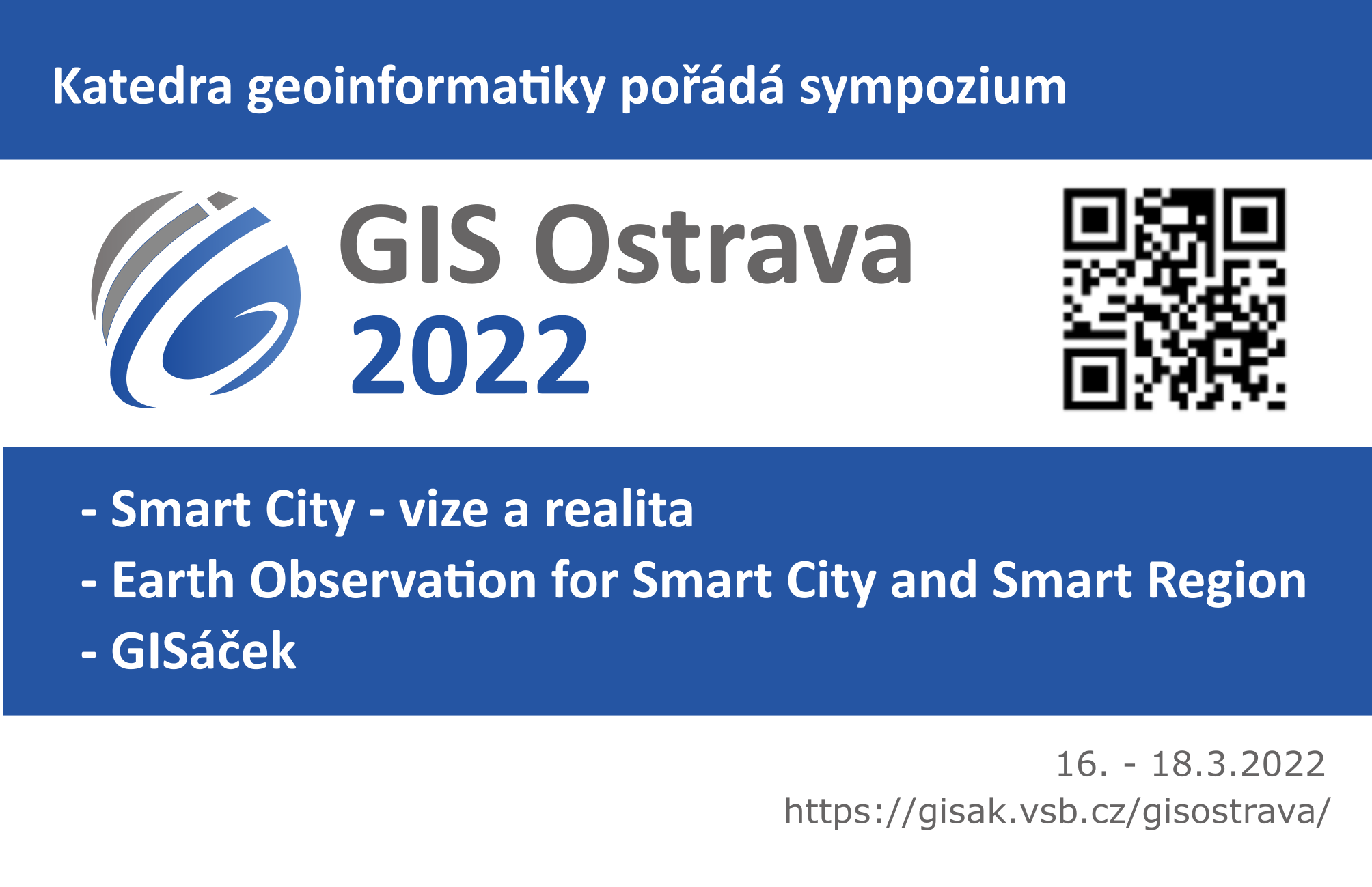
Sympozium GIS Ostrava 2022 bude kvůli COVID opatřením probíhat opět bohužel jen on-line formou. Bude se konat ve dnech 16. – 18. března 2022 a v rámci něj se chystají konference: Česká konference Smart City – vize a realita (http://gis.vsb.cz/gisostrava/) – přijímání referátů včetně abstraktů do 31.1.2022 Mezinárodní konference Earth Observation for Smart City and […]
The post Sympozium GIS Ostrava 2022 bude zase online appeared first on GISportal.cz.
Robotic Skies and Emesent partner to provide local drone technology servicing for American customers
26.1.2022 1:54 GISCafe.com Webcasts-Webinars Robotic Skies and Australian drone technology company Emesent announce a partnership to provide local service and repair for Emesent products in the …Australian spacetech companies partner to deliver the world's first on-demand satellite imaging platform.
26.1.2022 1:25 GISCafe.com Webcasts-Webinars January 25, 2022 -- Over the course of several decades, satellite imagery has emerged as one of the most critical tools for monitoring the …Bentley Systems Going digital with big data
25.1.2022 22:24 Bentley SystemsPressCoverage
TechX, Middle East
Read the articleBringing BIM to a New Level
25.1.2022 22:15 Bentley SystemsPressCoverage
Connected World, USA
Read the articleSingapore Land Authority Uses 3D Reality Modeling and Mapping
25.1.2022 21:20 Bentley SystemsPressCoverage
AECCafe, USA
Read the articleTop 20 Software Used In Naval Architecture
25.1.2022 21:09 Bentley SystemsPressCoverage
Marine Insight, USA
Read the articleRussian Farm Explores Use of XAG Agricultural Drones to Boost Rice Yield
25.1.2022 21:02 GISCafe.com Webcasts-Webinars KRASNODAR, Russia, Jan. 25, 2022 — (PRNewswire) — In the South of Russia, XAG's agricultural drone has been introduced to the full cycle …Hypersonix and Kratos Sign Agreement to Develop and Fly DART AE Hypersonic Drone
25.1.2022 21:01 GISCafe.com Webcasts-Webinars SAN DIEGO, Jan. 25, 2022 (GLOBE NEWSWIRE) -- Hypersonix Launch Systems Ltd. and Kratos Defense & Security Solutions, Inc. (NASDAQ: KTOS) have …NV5 Selected by Midwest Utility for $8 Million Geospatial Vegetation Management Contracts
25.1.2022 21:01 GISCafe.com Webcasts-Webinars HOLLYWOOD, Fla., Jan. 25, 2022 (GLOBE NEWSWIRE) -- NV5 Global, Inc. (the “Company” or “NV5”) (Nasdaq: NVEE), a provider of compliance, …Delek US Gains First BVLOS Approval for U.S. Refineries Using Percepto Drone and AI Solution
25.1.2022 21:01 GISCafe.com Webcasts-Webinars MODI'IN, Israel, Jan. 25, 2022 — (PRNewswire) — Percepto, pioneering autonomous inspection by industrial robotics, announced …Vance Street Takes Critical Asset Monitoring to the Cloud
25.1.2022 21:01 GISCafe.com Webcasts-Webinars VANCOUVER, BC, Jan. 25, 2022 — (PRNewswire) — Terra Insights, a portfolio company of Vance Street Capital LLC, today announced its …Qumulo Unveils Top Unstructured Data Storage Predictions for 2022
25.1.2022 21:01 GISCafe.com Webcasts-Webinars Growth in unstructured data, focus on cloud infrastructure, and simplification of data access and management will continue to drive …S&P CORELOGIC CASE-SHILLER INDEX REPORTS 18.8% ANNUAL HOME PRICE GAIN IN NOVEMBER
25.1.2022 21:01 GISCafe.com Webcasts-Webinars NEW YORK, Jan. 25, 2022 — (PRNewswire) — S&P Dow Jones Indices (S&P DJI) today released the latest results for the S&P …Práca YMS: Programátor medior/senior pre vývoj mapových aplikácií
25.1.2022 20:37 Geocommunity.skPríspevok Práca YMS: Programátor medior/senior pre vývoj mapových aplikácií zobrazený najskôr GeoCommunity.sk.
Práca v YMS: Programátor medior/senior pre vývoj mapových aplikácií
25.1.2022 20:37 Geocommunity.skPríspevok Práca v YMS: Programátor medior/senior pre vývoj mapových aplikácií zobrazený najskôr GeoCommunity.sk.
Podcast by Tiina Perttula, Chair of the Infrastructure Room steering committee
25.1.2022 20:01 buildingSMART.orgTiina’s career in civil engineering includes the Finnish Transport Infrastructure Agency and is now an InfraBIM specialist with Ramboll. She is also the chair of buildingSMART International’s Infrastructure program. Hear Tiina recount her experiences of delivering digital transformation in the construction industry and explore the benefits of data sharing on complex projects, limitations still to…
The post Podcast by Tiina Perttula, Chair of the Infrastructure Room steering committee appeared first on buildingSMART International.
The Next Era of Technology Adoption Facebook Twitter Pinterest
25.1.2022 19:00 Bentley SystemsPressCoverage
Connected World, USA
Read the articleAEGEA Saneamento Infra Inteligente Program
25.1.2022 18:47 Bentley SystemsPressCoverage
Informed Infrastructure, USA
Read the articleCritigen Rebrands as Locana Leading a New Era in Location Intelligence
25.1.2022 18:41 GISCafe.com Webcasts-Webinars New Company Name and Vision Grounded in Market Growth and Planned ExpansionDENVER — (BUSINESS WIRE) — January 25, 2022 — …
Geostatistics in Infrastructure
25.1.2022 18:19 Bentley SystemsPressCoverage
Connected World, USA
Read the articleWinning Geotechnical Project for Bentley YII Awards
25.1.2022 18:02 Bentley SystemsPressCoverage
GeoPrac.net, USA
Read the articleGeospatial technology that will define 2022
25.1.2022 17:31 Bentley SystemsPressCoverage
GeoWeek News, USA
Read the articleDigital Twin Builds Our Sustainable Infrastructure
25.1.2022 16:43 Bentley SystemsPressCoverage
Connected World, USA
Read the articleGoing Digital in Infrastructure
25.1.2022 16:34 Bentley SystemsPressCoverage
Peggy Smedley Show, USA
Read the articleThe Future Is iTwin
25.1.2022 16:24 Bentley SystemsPressCoverage
Peggy Smedley Show, USA
Read the articleCritigen Rebrands as Locana Leading a New Era in Location Intelligence
25.1.2022 16:24 GISCafe.com Webcasts-Webinars New Company Name and Vision Grounded in Market Growth and Planned ExpansionDENVER — (BUSINESS WIRE) — January 25, 2022 — …
Chongqing and Guizhou Organizations Advance Construction of Taihong Yangtze River Bridge
25.1.2022 16:03 Bentley SystemsPressCoverage
Civil + Structural Engineer, USA
Read the articleThe buildingSMART International Virtual Summit Spring 2022
25.1.2022 15:51 buildingSMART.orgLondon, U.K. - January 25, 2022 - buildingSMART International has taken the decision to postpone the International Standards Summit that was scheduled for March 2022 in Rome, Italy. This event has now been postponed to 2023 in the same location. buildingSMART International will now host a virtual summit taking place between 28 March – 1st April 2022.…
The post The buildingSMART International Virtual Summit Spring 2022 appeared first on buildingSMART International.
Synchronize Your Construction Components
25.1.2022 15:47 Bentley SystemsPressCoverage
Cadalyst, USA
Read the articleEUSPA to further boost space investments with CASSINI
25.1.2022 14:44 European GNSS Agency
The European Commission, the EU Agency for the Space Programme (EUSPA), the European Space Agency (ESA), and the European Investment Fund (EIF) committed to multiplying the benefits of space technology to businesses. This initiative implies attracting more private investment funds, running capacity building activities, sharing expertise, organizing matchmaking, and promoting the markets. CASSINI is central to this endeavour.
DG DEFIS Director-General Timo Pesonen, EUSPA Executive Director, Rodrigo da Costa, ESA Director-General Josef Aschbacher, Chief Executive of the European Investment Fund Alain Godard gathered at the Egmont Palace in Brussels on the occasion of the 14th edition of the European Space Conference 2022. During this event, they agreed on the principles of cooperation to support SMEs in the space sector, fostering on exchange of information and engaging in joint cross-functional actions towards space entrepreneurship.
Dedicated to promoting the commercialization of Galileo, EGNOS, and Copernicus data and services to increase the market share of the EU space actors, EUSPA has been engaging with companies of all sizes from a broad spectrum of industries, many of which had not used space services in their activities before.
Through capacity-building, and supporting their access to financial resources, mentoring and market know-how, EUSPA helps to create breakthroughs for space entrepreneurship.
Read this: The clock is ticking! Have you submitted your Horizon Europe proposal?
The ‘’New Space’’ paradigm is however reshaping the industry’s landscape resulting in a greater need for better access to risk capital and other forms of growth financing. Anticipating this need, EUSPA is ready to take EU space entrepreneurship to the next level by leveraging investments, its know-how and capacity building within CASSINI Space Entrepreneurship Growth Funding Initiative, together with European Investment Fund, the European Commission, and the European Space Agency.
Read this: CASSINI hackathon leverages space to digitise green spaces
These organisations are committed to bringing together their expertise and experience to leverage new investment support for the European space-based economy. The common objective is to create high-skilled jobs in the EU and improve the day-to-day lives of Europeans by supporting innovative companies and accelerating the development of new applications that use European global navigation satellite systems and earth observation services.
‘’EUSPA has a long history of cooperation with the European Investment Bank group and other private and public investors. I am pleased to see that today we reinforce our collaboration to support developing innovative, creative, and successful companies using EU space technologies,’’ said EUSPA Executive Director, Rodrigo da Costa. ‘’It is another step to contribute to the growth of the EU Space industry and its market share to boost our common economy in this very competitive global environment,’’ he concluded.
Media note: This feature can be republished without charge provided the European Union Agency for the Space Programme (EUSPA) is acknowledged as the source at the top or the bottom of the story. You must request permission before you use any of the photographs on the site. If you republish, we would be grateful if you could link back to the EUSPA website (http://www.euspa.europa.eu).
EUSPA to further boost space investments with CASSINI
25.1.2022 14:44 European GNSS AgencyThe European Commission, the EU Agency for the Space Programme (EUSPA), the European Space Agency (ESA), and the European Investment Fund (EIF) committed to multiplying the benefits of space technology to businesses. This initiative implies attracting more private investment funds, running capacity building activities, sharing expertise, organizing matchmaking, and promoting the markets. CASSINI is central to this endeavour.
DG DEFIS Director-General Timo Pesonen, EUSPA Executive Director, Rodrigo da Costa, ESA Director-General Josef Aschbacher, Chief Executive of the European Investment Fund Alain Godard gathered at the Egmont Palace in Brussels on the occasion of the 14th edition of the European Space Conference 2022. During this event, they agreed on the principles of cooperation to support SMEs in the space sector, fostering on exchange of information and engaging in joint cross-functional actions towards space entrepreneurship.
Dedicated to promoting the commercialization of Galileo, EGNOS, and Copernicus data and services to increase the market share of the EU space actors, EUSPA has been engaging with companies of all sizes from a broad spectrum of industries, many of which had not used space services in their activities before.
Through capacity-building, and supporting their access to financial resources, mentoring and market know-how, EUSPA helps to create breakthroughs for space entrepreneurship.
Read this: The clock is ticking! Have you submitted your Horizon Europe proposal?
The ‘’New Space’’ paradigm is however reshaping the industry’s landscape resulting in a greater need for better access to risk capital and other forms of growth financing. Anticipating this need, EUSPA is ready to take EU space entrepreneurship to the next level by leveraging investments, its know-how and capacity building within CASSINI Space Entrepreneurship Growth Funding Initiative, together with European Investment Fund, the European Commission, and the European Space Agency.
Read this: CASSINI hackathon leverages space to digitise green spaces
These organisations are committed to bringing together their expertise and experience to leverage new investment support for the European space-based economy. The common objective is to create high-skilled jobs in the EU and improve the day-to-day lives of Europeans by supporting innovative companies and accelerating the development of new applications that use European global navigation satellite systems and earth observation services.
‘’EUSPA has a long history of cooperation with the European Investment Bank group and other private and public investors. I am pleased to see that today we reinforce our collaboration to support developing innovative, creative, and successful companies using EU space technologies,’’ said EUSPA Executive Director, Rodrigo da Costa. ‘’It is another step to contribute to the growth of the EU Space industry and its market share to boost our common economy in this very competitive global environment,’’ he concluded.
Media note: This feature can be republished without charge provided the European Union Agency for the Space Programme (EUSPA) is acknowledged as the source at the top or the bottom of the story. You must request permission before you use any of the photographs on the site. If you republish, we would be grateful if you could link back to the EUSPA website (http://www.euspa.europa.eu).
20220125_Vedoucí oddělení aktualizace a dokumentace KN – odborný rada
25.1.2022 10:39 ČÚZK - předpisy a opatření Katastrální úřad pro Středočeský kraj - Katastrální pracoviště Beroun Vyhlášení výběrového řízení: Vedoucí oddělení aktualizace a dokumentace KN – odborný rada V části "Úřední deska", v sekci "Oznámení a jiná úřední sdělení" bylo vystaveno "Oznámení o vyhlášení výběrového řízení na obsazení služebního místa Vedoucí oddělení aktualizace a dokumentace KN – odborný rada"20220125_Vedoucí oddělení aktualizace a dokumentace KN – odborný rada
25.1.2022 10:39 ČÚZK /Urady/Katastralni-urady/Katastralni-urady/Katastralni-urad-pro-Stredocesky-kraj/Katastralni-pracoviste/KP-Beroun/O-uradu/Aktuality/20210113_odborny-rada,-reditel-Katastralniho-(3)Vedoucí oddělení aktualizace a dokumentace KN – odborný rada
25.1.2022 10:39 ČÚZK /Urady/Katastralni-urady/Katastralni-urady/Katastralni-urad-pro-Stredocesky-kraj/Uredni-deska/Oznameni-a-jina-uredni-sdeleni/Volna-mista/Vedouci-oddeleni-aktualizace-a-dokumentace-KN-–-odVedoucí oddělení aktualizace a dokumentace KN – odborný rada
25.1.2022 10:39 ČÚZK - předpisy a opatření Katastrální úřad pro Středočeský kraj - Katastrální pracoviště Berounvypisuje výběrové řízení na místo Vedoucí oddělení aktualizace a dokumentace KN – odborný rada
Vedoucí oddělení aktualizace a dokumentace KN – odborný rada
Vedoucí oddělení aktualizace a dokumentace KN – odborný rada
25.1.2022 10:39 ČÚZK - volná místa Katastrální úřad pro Středočeský kraj - Katastrální pracoviště Beroun vypisuje výběrové řízení na místo Vedoucí oddělení aktualizace a dokumentace KN – odborný radaobnova katastrálního operátu v oddělení aktualizace KN Katastrálního pracoviště Strakonice (ID SM 30
25.1.2022 10:38 ČÚZK /Urady/Katastralni-urady/Katastralni-urady/Katastralni-urad-pro-Jihocesky-kraj/Uredni-deska/Oznameni-a-jina-uredni-sdeleni/Volna-mista/DMS/obnova-katastralniho-operatu-v-oddeleni-aktualizacobnova katastrálního operátu v oddělení aktualizace KN Katastrálního pracoviště Strakonice (ID SM 30
25.1.2022 10:38 ČÚZK - předpisy a opatření Katastrální úřad pro Jihočeský kraj Katastrální pracoviště Strakonicevypisuje výběrové řízení na místo
obnova katastrálního operátu v oddělení aktualizace KN Katastrálního pracoviště Strakonice (ID SM 30000296/3003920)
obnova katastrálního operátu v oddělení aktualizace KN Katastrálního pracoviště Strakonice (ID SM 30
25.1.2022 10:38 ČÚZK - volná místa Katastrální úřad pro Jihočeský kraj Katastrální pracoviště Strakonice vypisuje výběrové řízení na místo obnova katastrálního operátu v oddělení aktualizace KN Katastrálního pracoviště Strakonice (ID SM 30První kroky v ArcGIS GeoBIM
25.1.2022 10:07 blog ARCDATA Světy GIS a BIM se propojují v prostředí aplikace ArcGIS GeoBIM. Naučíme vás, jak ji správně nastavit, abyste spolupráci obou těchto systémů mohli využívat i ve vašich projektech.ArcGIS GeoBIM
25.1.2022 10:07 blog ARCDATA Jednou z posledních novinek mezi aplikacemi ArcGIS je ArcGIS GeoBIM, která propojuje světy GIS a BIM. Pojďme si ji v tomto článku představit.20220125_Odborný / vrchní referent oddělení aktualizace a dokumentace KN
25.1.2022 9:43 ČÚZK - předpisy a opatření Katastrální úřad pro Středočeský kraj - Katastrální pracoviště Beroun Vyhlášení výběrového řízení: Odborný / vrchní referent oddělení aktualizace a dokumentace KN V části "Úřední deska", v sekci "Oznámení a jiná úřední sdělení" bylo vystaveno "Oznámení o vyhlášení výběrového řízení na obsazení služebního místa Odborný / vrchní referent oddělení aktualizace a dokumentace KN"20220125_Odborný / vrchní referent oddělení aktualizace a dokumentace KN
25.1.2022 9:43 ČÚZK /Urady/Katastralni-urady/Katastralni-urady/Katastralni-urad-pro-Stredocesky-kraj/Katastralni-pracoviste/KP-Beroun/O-uradu/Aktuality/20210113_odborny-rada,-reditel-Katastralniho-(2)Odborný / vrchní referent oddělení aktualizace a dokumentace KN
25.1.2022 9:42 ČÚZK - předpisy a opatření Katastrální úřad pro Středočeský kraj - Katastrální pracoviště Berounvypisuje výběrové řízení na místo Odborný / vrchní referent oddělení aktualizace a dokumentace KN
Odborný / vrchní referent oddělení aktualizace a dokumentace KN
Odborný / vrchní referent oddělení aktualizace a dokumentace KN
25.1.2022 9:42 ČÚZK /Urady/Katastralni-urady/Katastralni-urady/Katastralni-urad-pro-Stredocesky-kraj/Uredni-deska/Oznameni-a-jina-uredni-sdeleni/Volna-mista/Odborny-vrchni-referent-oddeleni-aktualizace-a-dOdborný / vrchní referent oddělení aktualizace a dokumentace KN
25.1.2022 9:42 ČÚZK - volná místa Katastrální úřad pro Středočeský kraj - Katastrální pracoviště Beroun vypisuje výběrové řízení na místo Odborný / vrchní referent oddělení aktualizace a dokumentace KN20220125_Vedoucí oddělení obnovy katastrálního operátu 03110 - odborný rada Technické sekce KÚ SČK
25.1.2022 9:03 ČÚZK - předpisy a opatření Katastrální úřad pro Středočeský kraj Vyhlášení výběrového řízení: Vedoucí oddělení obnovy katastrálního operátu 03110 - odborný rada Technické sekce Katastrálního úřadu pro Středočeský kraj V části "Úřední deska", v sekci "Oznámení a jiná úřední sdělení" bylo vystaveno "Oznámení o vyhlášení výběrového řízení na obsazení systemizovaného místa Vedoucí oddělení obnovy katastrálního operátu 03110 - odborný rada Technické sekce Katastrálního úřadu pro Středočeský kraj"20220125_Vedoucí oddělení obnovy katastrálního operátu 03110 - odborný rada Technické sekce KÚ SČK
25.1.2022 9:03 ČÚZK /Urady/Katastralni-urady/Katastralni-urady/Katastralni-urad-pro-Stredocesky-kraj/O-uradu/Aktuality/20220105_Rada-odborny-rada-–-interni-auditor-(1)Vedoucí oddělení obnovy katastrálního operátu 03110 - odborný rada Technické sekce Katastrálního úřa
25.1.2022 9:01 ČÚZK - předpisy a opatření Katastrální úřad pro Středočeský kraj - technická sekcevypisuje výběrové řízení na místo Vedoucí oddělení obnovy katastrálního operátu 03110 - odborný rada Technické sekce Katastrálního úřadu pro Středočeský kraj
Vedoucí oddělení obnovy katastrálního operátu 03110 - odborný rada Technické sekce Katastrálního úřadu pro Středočeský kraj