


![]()

zprávy
zdroje zpráv:Bentley’s Year in Infrastructure dives deep into digital twins
10.12.2020 17:54 Bentley SystemsPress Coverage
Schnitger Corp, US
Read the articleBentley Systems and Microsoft to digitise urban planning
10.12.2020 17:50 Bentley SystemsPress Coverage
The Record, UK
Read the articleHighways England project planning provides a springboard for latest Bentley launch
10.12.2020 17:48 Bentley SystemsPress Coverage
New Civil Engineer, UK
Read the articleMark Bew's consultancy PCSG bought by Bentley
10.12.2020 17:45 Bentley SystemsPress Coverage
BIM+, UK
Read the articleVelodyne Lidar Introduces Solid State Sensor for Autonomous Mobile Robotics and Last-Mile Delivery
10.12.2020 16:34 GISCafe.com Webcasts-Webinars Velarray M1600 Provides Advanced Perception for Rapidly Growing Autonomous Robot MarketSAN JOSE, Calif. — (BUSINESS WIRE) — December 10, …
Quantum Spatial, North America's Largest Provider of Geospatial Data Services and Solutions, Rebrands as NV5 Geospatial
10.12.2020 16:34 GISCafe.com Webcasts-Webinars Innovative Remote Sensing, Acquisition and Analytics Solutions are Key Capabilities in NV5 Global's Comprehensive Engineering PortfolioHOLLYWOOD, …
Built Environment Consultancy Acquired
10.12.2020 16:27 Bentley SystemsPress Coverage
Insider Media Limited, UK
Read the articleSiemens and Bentley help manage performance of oil & gas assets
10.12.2020 16:18 Bentley SystemsPress Coverage
Gas to Power Journal, UK
Read the articleShell Deepwater Selects Bentley’s iTwin Platform for Project Delivery
10.12.2020 15:57 Bentley SystemsPress Coverage
GeoConnexion, UK
Read the articleReef Support wins Copernicus Masters top prize
10.12.2020 15:25 ESA Observing the Earth
Reef Support won this year’s Copernicus Masters competition, and were honoured during the online Space Awards on 8 December as part of the European Space Week 2020. The innovative idea uses Copernicus Sentinel data and artificial intelligence to detect coral bleaching, algal blooms, sediment plumes and human debris.
Návod: Jak vytvořit 3D pohled na terén s pomocí Google Maps a modelovacího softwaru Blender
10.12.2020 15:03 GeoBusinessV YouTube kanálu CG Geek je většina videí věnována 3D modelování a animování pro filmy. Pro ukázky v následujícím videu CG Geek použil open source 3D modelovací software Blender a družicové snímky z Google Maps. Výsledkem je 3D model terénu.
The post Návod: Jak vytvořit 3D pohled na terén s pomocí Google Maps a modelovacího softwaru Blender appeared first on GeoBusiness.
HOTOVOSTNÍ PLATBY V ZÁVĚRU ROKU 2020
10.12.2020 14:28 ČÚZK /Urady/Katastralni-urady/Katastralni-urady/Katastralni-urad-pro-Olomoucky-kraj/O-uradu/Aktuality/HOTOVOSTNI-PLATBY-V-ZAVERU-ROKU-2020HOTOVOSTNÍ PLATBY V ZÁVĚRU ROKU 2020
10.12.2020 14:28 ČÚZK - předpisy a opatření Katastrální úřad pro Olomoucký kraj zveřejnil novou aktualitu:HOTOVOSTNÍ PLATBY V ZÁVĚRU ROKU 2020
Upozorňujeme, že v posledním týdnu roku, tj. dne 28. a 30. 12. 2020 nebude možná úhrada správních poplatků v hotovosti.
Správní poplatek bude možné uhradit platební kartou nebo bezhotovostním převodem, příp. kolkovou známkou zakoupenou u prodejců cenin.
Děkujeme za pochopení a přejeme klientům příjemné prožití vánočních svátků.
Ing. Daniel Janošík, ředitel úřadu
Geomatics on the Move: the results are in
10.12.2020 14:15 European GNSS Agency
Alphamonitoring System, from the joint Italian-French team Alphageomega, has taken the Traditional Geomatics prize in this year’s Geomatics on the Move Competition, while the Integrated Geomatics Prize went to the Greek team 3 Deep Vision for their project Bathymetry from UAV Imagery and Machine Learning. The winners shared in the overall prize of EUR 30,000, with a total of 8 prizes offered in the two categories.
The Traditional Geomatics category looked for solutions in which the main innovation was based on the use of EGNSS, employing traditional equipment such as surveying or GIS grade GNSS receivers. In this category, Alphageomega designed and built an all-in-one system that helps to improve remote real-time knowledge of displacements at sensitive critical infrastructures and the surrounding environment.
Meanwhile, the Integrated Geomatics category targeted integrated surveying solutions that use Galileo or EGNOS along with tools and technologies such as drones, mobile mapping, laser scanners or Augmented/Mixed Reality, both within geomatics applications or beyond.
The winner in this category - Bathymetry from UAV Imagery and Machine Learning - aims to implement a scalable and transferable web service for mapping shallow waters. This web service will facilitate the detailed and accurate monitoring and mapping of sensitive coastal areas, especially in times of climate crisis, taking as input georeferenced UAV images or 3D point clouds.
Targeted solutions
“With the Geomatics on the Move Prize, born from our collaboration with the CLGE and the CLGE Young Surveyors’ Prize, we are encouraging innovators to leverage space technology and target real needs in the mapping and surveying community. Despite being the first edition in this new format, I was very impressed with the quality of the entries and congratulate the worthy winners,” said GSA Head of Market Development Fiammetta Diani.
Read this: Want to know more about EGNSS for geomatics?
This year’s Geomatics on the Move competition marks the ninth year of partnership between the Council of European Geodetic Surveyors and the GSA. Through this initiative, the GSA aims to further increase the use of Galileo, EGNOS and Copernicus in the field of geomatics and to increase awareness of the benefits these EU Space Programmes provide toward fostering innovative geomatics applications.
Geomatics on the Move is an ideas competition. The contenders had to present their solutions and demonstrate them through a written submission in the form of a poster and a live pitch at the finals. The prizes were awarded at an online ceremony on December 9, held as part of European Space Week.
Alphamonitoring system wins Geomatics on the Move traditional prize
10.12.2020 14:15 European GNSS AgencyAlphamonitoring System, from the joint Italian-French team Alphageomega, has taken the Traditional Geomatics prize in this year’s Geomatics on the Move Competition, while the Integrated Geomatics Prize went to the Greek team 3 Deep Vision for their project Bathymetry from UAV Imagery and Machine Learning. The winners shared in the overall prize of EUR 30,000, with a total of 10 prizes offered in the two categories.
The Traditional Geomatics category looked for solutions in which the main innovation was based on the use of EGNSS, employing traditional equipment such as surveying or GIS grade GNSS receivers. In this category, Alphageomega designed and built an all-in-one system that helps to improve remote real-time knowledge of displacements at sensitive critical infrastructures and the surrounding environment.
Meanwhile, the Integrated Geomatics category targeted integrated surveying solutions that use Galileo or EGNOS along with tools and technologies such as drones, mobile mapping, laser scanners or Augmented/Mixed Reality, both within geomatics applications or beyond.
The winner in this category - Bathymetry from UAV Imagery and Machine Learning - aims to implement a scalable and transferable web service for mapping shallow waters. This web service will facilitate the detailed and accurate monitoring and mapping of sensitive coastal areas, especially in times of climate crisis, taking as input georeferenced UAV images or 3D point clouds.
Targeted solutions
“With the Geomatics on the Move Prize, born from our collaboration with the CLGE and the CLGE Young Surveyors’ Prize, we are encouraging innovators to leverage space technology and target real needs in the mapping and surveying community. Despite being the first edition in this new format, I was very impressed with the quality of the entries and congratulate the worthy winners,” said GSA Head of Market Development Fiammetta Diani.
Read this: Want to know more about EGNSS for geomatics?
This year’s Geomatics on the Move competition marks the ninth year of partnership between the Council of European Geodetic Surveyors and the GSA. Through this initiative, the GSA aims to further increase the use of Galileo, EGNOS and Copernicus in the field of geomatics and to increase awareness of the benefits these EU Space Programmes provide toward fostering innovative geomatics applications.
Geomatics on the Move is an ideas competition. The contenders had to present their solutions and demonstrate them through a written submission in the form of a poster and a live pitch at the finals. The prizes were awarded at an online ceremony on December 9, held as part of European Space Week.
Geomatics on the Move: the results are in
10.12.2020 14:15 European GNSS AgencyAlphamonitoring System, from the joint Italian-French team Alphageomega, has taken the Traditional Geomatics prize in this year’s Geomatics on the Move Competition, while the Integrated Geomatics Prize went to the Greek team 3 Deep Vision for their project Bathymetry from UAV Imagery and Machine Learning. The winners shared in the overall prize of EUR 30,000, with a total of 10 prizes offered in the two categories.
The Traditional Geomatics category looked for solutions in which the main innovation was based on the use of EGNSS, employing traditional equipment such as surveying or GIS grade GNSS receivers. In this category, Alphageomega designed and built an all-in-one system that helps to improve remote real-time knowledge of displacements at sensitive critical infrastructures and the surrounding environment.
Meanwhile, the Integrated Geomatics category targeted integrated surveying solutions that use Galileo or EGNOS along with tools and technologies such as drones, mobile mapping, laser scanners or Augmented/Mixed Reality, both within geomatics applications or beyond.
The winner in this category - Bathymetry from UAV Imagery and Machine Learning - aims to implement a scalable and transferable web service for mapping shallow waters. This web service will facilitate the detailed and accurate monitoring and mapping of sensitive coastal areas, especially in times of climate crisis, taking as input georeferenced UAV images or 3D point clouds.
Targeted solutions
“With the Geomatics on the Move Prize, born from our collaboration with the CLGE and the CLGE Young Surveyors’ Prize, we are encouraging innovators to leverage space technology and target real needs in the mapping and surveying community. Despite being the first edition in this new format, I was very impressed with the quality of the entries and congratulate the worthy winners,” said GSA Head of Market Development Fiammetta Diani.
Read this: Want to know more about EGNSS for geomatics?
This year’s Geomatics on the Move competition marks the ninth year of partnership between the Council of European Geodetic Surveyors and the GSA. Through this initiative, the GSA aims to further increase the use of Galileo, EGNOS and Copernicus in the field of geomatics and to increase awareness of the benefits these EU Space Programmes provide toward fostering innovative geomatics applications.
Geomatics on the Move is an ideas competition. The contenders had to present their solutions and demonstrate them through a written submission in the form of a poster and a live pitch at the finals. The prizes were awarded at an online ceremony on December 9, held as part of European Space Week.
20201210 - omezení chodu úřadu
10.12.2020 13:35 ČÚZK /Urady/Katastralni-urady/Katastralni-urady/Katastralni-urad-pro-Karlovarsky-kraj/Katastralni-pracoviste/KP-Karlovy-Vary/O-uradu/Aktuality/20201210-omezeni-chodu-uradu20201210 - omezení chodu úřadu
10.12.2020 13:35 ČÚZK - předpisy a opatření Katastrální úřad pro Karlovarský kraj - Katastrální pracoviště Karlovy Vary zveřejnil novou aktualitu: Upozornění Katastrálního pracoviště!Do 23.12.2020 dochází na Katastrálním pracovišti Karlovy Vary k omezení služeb pro veřejnost.
Více informací: Získat podrobnější informace k omezení služeb pro veřejnost (soubor ve formátu PDF)
Odborný referent/vrchní referent personálního oddělení v kanceláři ředitele katastrálního úřadu na K
10.12.2020 10:26 ČÚZK /Urady/Katastralni-urady/Katastralni-urady/Katastralni-urad-pro-Jihomoravsky-kraj/Uredni-deska/Oznameni-a-jina-uredni-sdeleni/Volna-mista/DMS/Odborny-referent-vrchni-referent-personalniho-oddeOdborný referent/vrchní referent personálního oddělení v kanceláři ředitele katastrálního úřadu na K
10.12.2020 10:26 ČÚZK - předpisy a opatření Katastrální úřad pro Jihomoravský kraj kancelář úřaduvypisuje výběrové řízení na místo
Odborný referent/vrchní referent personálního oddělení v kanceláři ředitele katastrálního úřadu na Katastrálním pracovišti pro Jihomoravský kraj
Odborný referent/vrchní referent personálního oddělení v kanceláři ředitele katastrálního úřadu na K
10.12.2020 10:26 ČÚZK - volná místa Katastrální úřad pro Jihomoravský kraj kancelář úřadu vypisuje výběrové řízení na místo Odborný referent/vrchní referent personálního oddělení v kanceláři ředitele katastrálního úřadu na KNová verze TurboCAD 27 CZ pro rok 2020/2021 již v prodeji!
10.12.2020 10:21 ŠPINAR - software Vážení zákazníci, dovolujeme si Vám nabídnout nové verze programů TurboCAD 27 CZ (2020/2021) pro kreslení ve 2D / 3D včetně vizualizací. Trvalá licence v českém nebo anglickém jazyce. Skvělý poměr silného výkonu / ceny! Vyberte si verzi TurboCADu, která Vám nejvíce bude vyhovovat. Novinky programu TurboCAD Platinum naleznete zde Demoverzi programu TuboCAD Platinum stáhnete zde. Novinky programu TurboCAD Professional naleznete zde Demoverzi programu TuboCAD Professional stáhnete zde. Novinky programu TurboCAD Deluxe naleznete zde ...Read moreNová verze TurboCAD 27 CZ pro rok 2020/2021 již v prodeji!
10.12.2020 10:21 ŠPINAR - softwareVážení zákazníci, dovolujeme si Vám nabídnout nové verze programů TurboCAD 27 CZ (2020/2021) pro kreslení ve 2D / 3D včetně vizualizací. Trvalá licence v českém nebo anglickém jazyce. Skvělý poměr silného výkonu / ceny! Vyberte si verzi TurboCADu, která Vám nejvíce bude vyhovovat. Novinky programu TurboCAD Platinum naleznete zde Demoverzi programu TuboCAD Platinum stáhnete zde. Novinky programu TurboCAD Professional naleznete zde Demoverzi programu TuboCAD Professional stáhnete zde. Novinky programu TurboCAD Deluxe naleznete zde ...Read more
The post Nová verze TurboCAD 27 CZ pro rok 2020/2021 již v prodeji! appeared first on ŠPINAR – software.
Sea-level monitoring satellite first results surpass expectations
10.12.2020 10:08 ESA Observing the Earth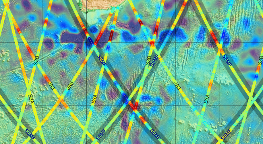
Launched less than three weeks ago, the Copernicus Sentinel-6 Michael Freilich satellite has not only returned its first data, but results also show that it is functioning far better than expected. Thanks to its new, sophisticated, altimetry technology, Sentinel-6 is poised to deliver exceptionally precise data on sea-level height to monitor the worrying trend of sea-level rise.
Ředitel/ka Ekonomického odboru
10.12.2020 8:35 Zeměměřický úřad Zeměměřický úřadvypisuje výběrové řízení na místo
Ředitel/ka Ekonomického odboru
Ředitel/ka Ekonomického odboru
10.12.2020 8:35 ČÚZK /Urady/Zememericky-urad/Uredni-deska/Oznameni-a-jina-uredni-sdeleni/Volna-mista/Reditel-ka-Ekonomickeho-odboruŘeditel/ka Ekonomického odboru
10.12.2020 8:35 ČÚZK - volná místa Zeměměřický úřad vypisuje výběrové řízení na místo Ředitel/ka Ekonomického odboruŘeditel/ka Ekonomického odboru
10.12.2020 8:35 ČÚZK - předpisy a opatření Zeměměřický úřadvypisuje výběrové řízení na místo
Ředitel/ka Ekonomického odboru
Brněnský GNSS seminář 2021 přesunut na příští rok 2022
10.12.2020 7:18 ZeměměřičV lednu se již od roku 2015 v Brně scházejí zájemci o využívání družicových metod v geodézii a katastru. Organizátoři letos rozhodli, že se seminář za stávající situace v lednu 2021 neuskuteční. Josef Weigel z pořádajícího Ústavu geodézie na Stavební fakultě VUT v Brně zaslal účastníkům loňského ročníku zprávu, ve které sděluje přesunutí semináře na začátek roku 2022. —————————————————————————————- Vážené kolegyně a kolegové […]
The post Brněnský GNSS seminář 2021 přesunut na příští rok 2022 appeared first on Zeměměřič.
Obec Markvartice letos převzala poslední z prioritních společných zařízení pozemkových úprav
10.12.2020 0:00 Státní pozemkový úřad Od zahájení pozemkových úprav v katastrálním území Markvartice uplynulo 10 let a do obce Markvartice přibylo několik povedených zrealizovaných opatření.Obec Markvartice leží v Ústeckém kraji, v okrese Děčín a rozkládá se v Českém středohoří v údolí říčky Bystrá. Od Děčína je vzdálena 11 km a má 681 obyvatel. Spolupráce s Pobočkou Děčín (dřívějším pozemkovým úřadem) odstartovala v roce 2010. V té době na Děčínsku nebyl pojem pozemkové úpravy příliš rozšířen. Pro ukázky zrealizovaných opatření musel tehdejší pozemkový úřad sahat převážně do jiných okresů. Přesto vlastníci zemědělské půdy v této krajině projevili zájem o pozemkové úpravy v jejich území a dnes jsou právě tato opatření prezentována dalším obcím, které začínají na pozemkovém úřadu tvořit frontu coby žadatelé pozemkových úprav.
Worldwide Server Market Revenue Grew 2.2% Year Over Year in the Third Quarter of 2020, According to IDC
9.12.2020 23:05 GISCafe.com Webcasts-Webinars FRAMINGHAM, Mass. — (BUSINESS WIRE) — December 9, 2020 —According to the International Data Corporation (IDC) Worldwide Quarterly …
Hexagon | NovAtel introduces new marine-certified GNSS receiver for nearshore applications
9.12.2020 20:39 GISCafe.com Webcasts-Webinars The multi-constellation MarinePak7 GNSS receiver supports Oceanix Correction Service and SPAN GNSS+INS technology for an assured 3D positioning …dSPACE and LeddarTech Join Forces to Drive Development of Lidar Innovations for Self-Driving Cars
9.12.2020 20:39 GISCafe.com Webcasts-Webinars PADERBORN, Germany, and QUEBEC CITY, Canada, Dec. 09, 2020 (GLOBE NEWSWIRE) -- dSPACE and LeddarTech®, a leader in level 1-5 ADAS and AD sensing …Esri's Web-Based Redistricting Solution to Be Used by Colorado
9.12.2020 20:39 GISCafe.com Webcasts-Webinars Esri Redistricting Brings Data and Transparency to Governments and Residents Redrawing District BoundariesREDLANDS, Calif. — (BUSINESS WIRE) …
Financování pozemkových úprav z rozpočtu ministerstva zemědělství v roce 2021
9.12.2020 17:00 ZeměměřičPřed pár dny vláda odsouhlasila navýšení rozpočtu ministerstva zemědělství. Redakce Zeměměřiče se na ministerstvu zeptala, jak to s finančními prostředky bude. Z tiskového oddělení MZe nám přišla odpověď, že “finanční prostředky, o kterých se v tiskové zprávě hovoří, jsou rozpočtem na pozemkové úpravy pro rok 2021. Na pozemkové úpravy je tak připraven rozpočet ve výši 2 mld. Kč […]
The post Financování pozemkových úprav z rozpočtu ministerstva zemědělství v roce 2021 appeared first on Zeměměřič.
Financování pozemkových úprav z rozpočtu ministerstva zemědělství v roce 2021
9.12.2020 17:00 ZeměměřičPřed pár dny vláda odsouhlasila navýšení rozpočtu ministerstva zemědělství. Redakce Zeměměřiče se na ministerstvu zeptala, jak to s finančními prostředky bude. Z tiskového oddělení MZe nám přišla odpověď, že „finanční prostředky, o kterých se v tiskové zprávě hovoří, jsou rozpočtem na pozemkové úpravy pro rok 2021. Na pozemkové úpravy je tak připraven rozpočet ve výši 2 mld. Kč […]
The post Financování pozemkových úprav z rozpočtu ministerstva zemědělství v roce 2021 appeared first on Zeměměřič.
vrchní referent/rada - obnova katastrálního operátu v oddělení aktualizace a dokumentace KN Katastrá
9.12.2020 15:28 ČÚZK - volná místa Katastrální úřad pro Jihočeský kraj Katastrální pracoviště Český Krumlov vypisuje výběrové řízení na místo vrchní referent/rada - obnova katastrálního operátu v oddělení aktualizace a dokumentace KN Katastrávrchní referent/rada - obnova katastrálního operátu v oddělení aktualizace a dokumentace KN Katastrá
9.12.2020 15:28 ČÚZK - předpisy a opatření Katastrální úřad pro Jihočeský kraj Katastrální pracoviště Český Krumlovvypisuje výběrové řízení na místo
vrchní referent/rada - obnova katastrálního operátu v oddělení aktualizace a dokumentace KN Katastrálního pracoviště Český Krumlov (ID SM 30000154/30003778)
ČÚZK ve čtvrtek 10.12.2020 od
9.12.2020 15:27 GEUSware ČÚZK ve čtvrtek 10.12.2020 od 16:30 do cca 18:00 zcela přeruší provoz Dálkového přístupu (DP) i Webových služeb dálkového přístupu (WSDP). Z tohoto důvodu budou v GEUSu nefunkční Podklady měření a Odesílání GP.Spanish team wins Farming by Satellite Prize 2020
9.12.2020 14:58 European GNSS Agency
Graniot, a team from Spain, has won this year’s 1st Farming by Satellite Prize. The winning team developed a web application that uses European satellite technologies to help agronomists and farmers monitor crops, reduce water waste and avoid poor fertilisation practices. The Farming by Satellite Prize promotes the use of GNSS and Earth observation in Europe and includes a special Africa Prize.
The Italian team Genuine received second prize in the competition for a web-based solution that identifies crop stress the optimal tractor path for irrigation and fertilisation using Copernicus, EGNOS and Galileo. The third prize went to AI4OceanFarming, also from Spain, for a solution that uses satellite data to identify ocean farming threats such as harmful algal blooms (HABs), ocean acidification (OA), and invasive species. Finally, the Special Africa Prize went to the Kenyan-Italian team GeoM&E for a solution that uses European satellite technology to monitor coffee diseases.
The winners beat stiff competition from 40 other young teams with innovative ideas. The judges selected first a short list of the best teams to then take their ideas forward to a ‘Deep Dive’ phase. The selected eight grand finalists had the opportunity to pitch their solutions during a final ‘live’ judging round.
An inspiring experience
“We’re honoured to be chosen as winners of the Farming by Satellite Prize 2020. We will put the EUR 5,000 cash prize to good use developing our satellite crop monitoring web application further. The whole journey has been a great experience that would not have be possible without the support of UGREmprendedora and the Andalucia Agrotech Digital Innovation Hub,” said Pablo Romero Díaz and Manuel Castro Ruiz from Graniot. “We’ve learnt so much. We have been inspired by the feedback from the judges and have enjoyed seeing the entries from all the grand finalists during the awards ceremony.”
Read this: A “Cerealist’s Diary”, the testimony of a wheat farmer
“The innovation and wide variety of agriculture applications submitted by young innovators this year has been wonderful to see. It confirms the value of encouraging the next generation of farmers to explore the use of satellite technologies in agriculture to enable sustainable farming practices,” said Joaquín Reyes González, who judged the competition on behalf of the European GNSS Agency (GSA).
Hans Dufourmont, a judge for the European Environment Agency (EEA), highlighted the environmental credentials of the entries: “The agricultural sector needs to continue developing sustainable food production practices and improve their impact on the environment and climate. It’s great to see Galileo and Copernicus convincing young farmers to become tech savvy entrepreneurs and develop competitive yet sustainable agriculture.”
Increased use of EGNSS and Copernicus in agriculture
The Farming by Satellite Prize is an initiative of the GSA and the EEA, supported by agricultural engineering equipment manufacturer CLAAS. The competition aims to increase the use of Galileo, EGNOS and Copernicus in European agriculture. The Prize also intends to raise awareness on the benefits the EU Space Programme provides toward fostering innovative and sustainable farming solutions. The objective of the Special Africa Prize is to encourage young Africans to develop satellite-based solutions that cater to the specific needs and resources of communities and lands in Africa.
Watch this: European Satellites for Agriculture
Commenting on the winning idea, Marcel Fölsch from CLAAS said: “The Graniot team has consistently presented a high-quality solution throughout all stages of this year’s competition. It is great to see their focus on olive farming in southern Europe, allowing them to narrow in on specific customer needs and present a compelling remote sensing solution to their users. We’re pleased to award the top prize to a team clearly driving the adoption of sustainable agriculture practises in Europe.”
Contestants were tasked with creating a new sustainable and environmentally friendly agriculture solution using Galileo, EGNOS and/or Copernicus. Solutions had to demonstrate a novel approach to the use of satellite services for farming, while ensuring accurate technical feasibility and a maximum impact on the farming industry.
Participation was open to young farmers, academics, and professionals between the ages of 18 and 32. They could take part as individuals or as a team of up to four. For the Special Africa Prize, at least one applicant was required to be a citizen of or resident in an African country.
For more information, click here.
Media note: This feature can be republished without charge provided the European GNSS Agency (GSA) is acknowledged as the source at the top or the bottom of the story. You must request permission before you use any of the photographs on the site. If you republish, we would be grateful if you could link back to the GSA website (http://www.gsa.europa.eu).
rada/odborný rada – vedoucí oddělení informací z KN a veřejných knih
9.12.2020 14:21 ČÚZK - volná místa Katastrální úřad pro hlavní město Prahu Katastrální pracoviště Praha vypisuje výběrové řízení na místo rada/odborný rada – vedoucí oddělení informací z KN a veřejných knihrada/odborný rada – vedoucí oddělení informací z KN a veřejných knih
9.12.2020 14:21 ČÚZK - předpisy a opatření Katastrální úřad pro hlavní město Prahu - Katastrální pracoviště Prahavypisuje výběrové řízení na místo
rada/odborný rada – vedoucí oddělení informací z KN a veřejných knih
rada/odborný rada – vedoucí oddělení informací z KN a veřejných knih
9.12.2020 14:21 ČÚZK /Urady/Katastralni-urady/Katastralni-urady/Katastralni-urad-pro-hlavni-mesto-Prahu/Uredni-deska/Oznameni-a-jina-uredni-sdeleni/Volna-mista/DMS/rada-odborny-rada-–-vedouci-oddeleni-informaci-z-Krada/odborný rada – vedoucí oddělení informací z KN a veřejných knih
9.12.2020 14:21 ČÚZK - volná místa Katastrální úřad pro hlavní město Prahu - Katastrální pracoviště Praha vypisuje výběrové řízení na místo rada/odborný rada – vedoucí oddělení informací z KN a veřejných knihrada/odborný rada – vedoucí oddělení informací z KN a veřejných knih
9.12.2020 14:21 ČÚZK - předpisy a opatření Katastrální úřad pro hlavní město Prahu Katastrální pracoviště Prahavypisuje výběrové řízení na místo
rada/odborný rada – vedoucí oddělení informací z KN a veřejných knih
ArcRevue 2/2020 v digitální podobě
9.12.2020 13:20 ARCDATA
Nejnovější číslo časopisu ArcRevue si již můžete přečíst ve formátu PDF. Naleznete v něm články o nových aplikacích Zeměměřického úřadu, o tom, jak GIS pomáhaly Armádě ČR v krizovém štábu COVID-19, o Základní topografické mapě 1 : 5000, o projektu Digitální technická mapa ČR a o mnoha dalších tématech.
Novinkou je i rozdělení časopisu v našem archivu po jednotlivých článcích, takže je můžete pohodlněji stahovat a sdílet.
MawisPhoto – dokumentujte stavby
9.12.2020 12:40 Hrdlička MawisPhoto je aplikací, která nově rozšiřuje Mawis – portál profesionálního stavebníka.MawisPhoto – dokumentujte stavby za pomoci mobilního telefonu skrze 3D modely
9.12.2020 12:38 Hrdlička MawisPhoto je aplikací, která nově rozšiřuje Mawis – portál profesionálního stavebníkaPlaces in Antarctica named in honour of ice scientists
9.12.2020 12:04 ESA Observing the Earth
Celebrating 200 years since the discovery of the Antarctic continent, the UK Committee for Antarctic Place-Names has named 28 mountains, glaciers and bays after modern-day scientists who have advanced our understanding of this remote continent. Four of the names on the list have strong links to ESA, having either worked on the development of polar-orbiting altimetry missions such as ERS-1, ERS-2, Envisat and CryoSat, or subsequently by using their data together with other satellite missions for key polar research projects.
Omezení provozu kontaktního místa v Bystřici nad Pernštejnem
9.12.2020 10:30 ČÚZK - předpisy a opatření Katastrální úřad pro Vysočinu - Katastrální pracoviště Žďár nad Sázavou zveřejnil novou aktualitu: Katastrální úřad pro Vysočinu, Katastrální pracoviště Žďár nad Sázavou oznamuje, že dne 28. 12. 2020 bude Kontaktní místo Bystřice nad Pernštejnem z provozních důvodů uzavřeno. V případě potřeby se obracejte na podatelnu Katastrálního pracoviště Žďár nad Sázavou, se sídlem Strojírenská 8, 591 27 Žďár nad Sázavou.Angsa Robotics wins overall prize in Galileo Masters 2020
9.12.2020 10:14 European GNSS Agency
Angsa Robotics has won the overall prize in the Galileo Masters 2020 with “Clive,” Germany’s first autonomous trash collection robot, which collects small pieces of rubbish left on grass or gravel that would otherwise cause ecological and economic problems.
Thanks to its unique artificial neural network architecture, “Clive” can move independently while detecting and localising individual objects, which enables it to clean grass and gravel areas. Individual objects such as bottle caps or cigarette butts are targeted for collection but insects are spared, in a win-win solution for the environment. Since conventional sweeping machines are designed for flat asphalt surfaces, they are unsuitable for these types of surfaces, so these surfaces have typically had to be cleaned manually.
“Clive” also creates an economic benefit for its customers. Its target use cases include the cleaning of festival venues after events and the daily cleaning of parks and other green spaces. Precise localisation via GNSS is essential to its operation: With better localisation, the robot can plan a more efficient path and clean a given area faster.
Forward-thinking applications
“Angsa Robotics is combining precise GNSS localisation with further state-of-the art techniques such as artificial intelligence and robotics. Its innovative solution is an impressive reflection of what the Agency was looking for with its three challenges in this year’s edition of Galileo Masters: forward-thinking applications of space for future generations,” European GNSS Agency (GSA) Executive Director Rodrigo da Costa said at the digital Space Awards.
After winning both the GSA Space for Our Planet Challenge and the Galileo Prize Bavaria, Angsa Robotics was presented with a EUR 10,000 cash prize as the Overall Winner of Galileo Masters 2020, having beat out 23 other challenge and prize winners. In addition, the pioneering start-up was selected as one of the winners of the Galileo Incubation Programme, which includes an incubation and acceleration prize package worth up to EUR 62,000.
The winners of the Galileo Masters 2020 international innovation competition were announced during the online Space Awards on 8 December as part of European Space Week 2020. Seventeen winners selected by the Galileo Prize Partners had the chance to present their ideas to an international audience at a Space Pitches session at EUSW on 7 December.
EGNSS driving innovation
European GNSS and the accurate, highly reliable positioning data it delivers is an essential element in the uptake of autonomous vehicles such as cars, drones, or robots. Autonomous vehicles are already a growing segment in the transport and automotive sector, in urban air mobility, and in the drone market.
By combining GNSS with on-board sensors and systems such as cameras, radar, or inertial sensors, robotic applications are also being developed for the construction, manufacturing, maintenance, monitoring, and the healthcare and household sectors. Satellite navigation data provides the accuracy, integrity, reliability, and availability required to operate autonomous vehicles.
Global innovation network for Galileo
Galileo Masters’ network of 101 partners from 18 countries focuses on the regional implementation of the competition to ensure a high level of diversity while enhancing both job growth potential and regional development opportunities. The competition’s backbone consists of 17 Prize Partners that are involved in specific areas at the local level, providing participants with valuable support in launching their businesses across Europe.
“Galileo Masters has given a significant boost to the rise of the GNSS industry in Europe,” said AZO CEO Thorsten Rudolph. “The top 100 companies that have grown out of the innovative ideas of more than 13,000 Galileo Masters participants since 2004 have created more than 3,300 jobs and generated EUR 178 million in total turnover in 2019. In recent years, these companies have also raised around EUR 524 million in venture capital.”
By fostering entrepreneurs and start-ups, Galileo Masters’ long-term objective is to strengthen Europe’s competitiveness with high-tech space solutions on a global scale. This was why the European Commission established Europe’s unique Galileo Incubation programme for the top six winners of Galileo Masters. For the fourth time, this programme will offer the year’s winners access to dedicated incubation services (worth up to EUR 372,000 in total) at their preferred incubation centre in the Europe-wide Galileo Masters network.
Media note: This feature can be republished without charge provided the European GNSS Agency (GSA) is acknowledged as the source at the top or the bottom of the story. You must request permission before you use any of the photographs on the site. If you republish, we would be grateful if you could link back to the GSA website (http://www.gsa.europa.eu).
Rada/odborný rada v oddělení právních vztahů k nemovitostem na Katastrálním pracovišti Hodonín
9.12.2020 10:02 ČÚZK /Urady/Katastralni-urady/Katastralni-urady/Katastralni-urad-pro-Jihomoravsky-kraj/Uredni-deska/Oznameni-a-jina-uredni-sdeleni/Volna-mista/DMS/Rada-odborny-rada-v-oddeleni-pravnich-vztahu-k-nemRada/odborný rada v oddělení právních vztahů k nemovitostem na Katastrálním pracovišti Hodonín
9.12.2020 10:02 ČÚZK - volná místa Katastrální úřad pro Jihomoravský kraj Katastrální pracoviště Hodonín vypisuje výběrové řízení na místo Rada/odborný rada v oddělení právních vztahů k nemovitostem na Katastrálním pracovišti HodonínRada/odborný rada v oddělení právních vztahů k nemovitostem na Katastrálním pracovišti Hodonín
9.12.2020 10:02 ČÚZK - předpisy a opatření Katastrální úřad pro Jihomoravský kraj Katastrální pracoviště Hodonínvypisuje výběrové řízení na místo
Rada/odborný rada v oddělení právních vztahů k nemovitostem na Katastrálním pracovišti Hodonín
Povodňový plán
9.12.2020 10:00 Středočeský kraj Byla aktualizována webová aplikace Povodňový plán. Zpracovatelem aplikace je společnost Hydrosoft Veleslavín s.r.o..Propojujeme naše služby a nabízíme komplexní řešení
9.12.2020 9:34 Hrdlička Služby jako je MawisPhoto a tvorba ortofotomap jsou nově na stránkách BIM3D.cz.Využijte jedinečnou nabídku na
9.12.2020 0:00 SolidVision Využijte jedinečnou nabídku na získání licence SWOOD zdarma a podpořte svoji efektivitu.
Využijte jedinečnou nabídku na
9.12.2020 0:00 SolidVision Využijte jedinečnou nabídku na získání licence SWOOD zdarma a podpořte svoji efektivitu.Evropské dotace budou pro období 2021 až 2027 větší o 450 miliard korun
8.12.2020 23:45 GeoBusinessČeská republika bude mít možnost čerpat v programovém období 2021 až 2027 evropské dotace zhruba 960 miliard korun. Proti původnímu návrhu z roku 2018 je to přibližně o 450 miliard korun více. V současném období může Česko čerpat asi 620 miliard korun. Na tiskové konferenci to uvedla ministryně pro místní rozvoj Klára Dostálová (ANO) s […]
The post Evropské dotace budou pro období 2021 až 2027 větší o 450 miliard korun appeared first on GeoBusiness.
Hexagon | AutonomouStuff Webinar Showcases How Velodyne’s Velarray H800 and PAEB Solution Can Power Advanced Driver Assistance Systems (ADAS) and Autonomy
8.12.2020 17:33 GISCafe.com Webcasts-Webinars SAN JOSE, Calif. — (BUSINESS WIRE) — December 8, 2020 —Velodyne Lidar, Inc. (Nasdaq: VLDR) today announced Dr. Mircea Gradu, the …
A Positive Signal—For Now: CoreLogic Reports Serious Delinquencies Leveled Off in September for the First Time Since Start of Pandemic
8.12.2020 17:33 GISCafe.com Webcasts-Webinars Record home equity and government protections keep foreclosure rates at historic lowsOverall delinquency rates have declined from a peak in May …
Woolpert Adds King Air 300 to Support Increase in International Mapping, Survey
8.12.2020 17:33 GISCafe.com Webcasts-Webinars The versatile aircraft is certified to carry topographic and bathymetric lidar sensors and has an effective range of 2,100 nautical miles.DENVER, …
Kratos Receives $37.7 Million Skyborg Program Contract Award from USAF Advanced Aircraft Office
8.12.2020 17:33 GISCafe.com Webcasts-Webinars SAN DIEGO, Dec. 08, 2020 (GLOBE NEWSWIRE) -- Kratos Defense & Security Solutions, Inc. (NASDAQ: KTOS), a leading National Security Solutions …ELTA North America Delivers Mobile Counter-sUAS Defense-in-Depth Capability to the U.S. DOD & DHS
8.12.2020 17:33 GISCafe.com Webcasts-Webinars ANNAPOLIS JUNCTION, Md., Dec. 8, 2020 — (PRNewswire) — ELTA North America announces the delivery of its advanced Counter Drone …Smart Cities Rise Up with Digital Twins
8.12.2020 16:24 Bentley SystemsPress Coverage
Constructech, USA
Read the articleBentley Systems acquires PCSG
8.12.2020 16:18 Bentley SystemsPress Coverage
Extranet Evolution, UK
Read the articleShell’s deepwater business selects Bentley’s digital twin platform
8.12.2020 16:14 Bentley SystemsPress Coverage
Offshore Technology, UK
Read the articleISKN Studio verze 10.x.4
8.12.2020 15:53 ARCDATAK dispozici je nová verze aplikace ISKN Studio 10.x.4, která podporuje aktuální, i starší verze systému ArcGIS. Více informací o funkcích a vlastnostech softwaru ISKN Studio naleznete na samostatné stránce.

FutureOn, Bentley form oil and gas digital twin collaboration
8.12.2020 15:44 Bentley SystemsPress Coverage
Offshore Magazine, USA
Read the articleBentley Systems announces finalists in Year in Infrastructure 2020 Awards program
8.12.2020 15:07 Bentley SystemsPress Coverage
Architosh, USA
Read the articleBentley Announces Partnership with Microsoft, Expanding Its Cloud-based Digital Twin Capability
8.12.2020 15:02 Bentley SystemsPress Coverage
ENR, USA
Read the articleinspektor Zeměměřického a katastrálního inspektorátu v Liberci
8.12.2020 14:34 ČÚZK /Urady/Zememericke-a-katastralni-inspektoraty/Zememericke-a-katastralni-inspektoraty/Zememericky-a-katastralni-inspektorat-v-Liberci/Uredni-deska/Oznameni-a-jina-uredni-sdeleni/Volna-mista/inspektor-Zememerickeho-a-katastralniho-inspektorainspektor Zeměměřického a katastrálního inspektorátu v Liberci
8.12.2020 14:34 ČÚZK - volná místa Zeměměřický a katastrální inspektorát v Liberci vypisuje výběrové řízení na místo inspektor Zeměměřického a katastrálního inspektorátu v Liberciinspektor Zeměměřického a katastrálního inspektorátu v Liberci
8.12.2020 14:34 ČÚZK - předpisy a opatření Zeměměřický a katastrální inspektorát v Libercivypisuje výběrové řízení na místo inspektor Zeměměřického a katastrálního inspektorátu v Liberci
inspektor Zeměměřického a katastrálního inspektorátu v Liberci
Stav komunikací II. a III. třídy
8.12.2020 12:20 Jihočeský kraj Mapová aplikace Stav komunikací II. a III. třídy byla aktualizována o rok 2019.Projekt spolufinancovaný EU - Fondem soudržnosti
8.12.2020 12:00 ČÚZK - předpisy a opatření Katastrální úřad pro Jihočeský kraj - Katastrální pracoviště Český Krumlov zveřejnil novou aktualitu: Projekt spolufinancovaný EU - Fondem soudržnostiUV955/2016 Katastrální pracoviště Č. Krumlov - výměna oken
(reg. č. CZ.05.5.18/0.0/0.0/18_100/ 0009270, Operační program Životní prostředí, č. výzvy: 05_18_100)
High accuracy and synergies in focus at UCP
8.12.2020 11:26 European GNSS Agency
European Space Week 2020 kicked off on Monday 7 December with the User Consultation Platform (UCP) plenary, where users from different market segments presented the results of work carried out during the UCP over the previous week. Copernicus users were included in the UCP for the first time, and possible services and applications arising from synergies between Copernicus and Galileo were very much in focus.
Opening the UCP plenary, GSA Executive Director Rodrigo da Costa noted that users were central to EGNSS. “This is why the User Consultation Platform is so important – it helps us to develop new services,” he said, adding that it is also a valuable tool for industry and for policy-makers, with inputs feeding into the development of new GNSS applications and into Horizon Europe downstream activities.
EGNSS for post-COVID recovery
Representing the Aviation segment, Vanessa Rullier, Senior Manager at the European Business Aviation Association, noted that recovery from COVID would depend on society’s ability to meet its social and environmental obligations. She said that more should be done to extend the use of EGNOS approaches to reduce aviation’s footprint. Synergies between EGNSS and Copernicus can play a role in finding the best sustainable trajectory for aircraft, she said.
Read this: ICAO approves new standards and recommended practices for EGNOS and Galileo
Captain Johan Gahnstrom from CompetenSEA noted a clear trend towards the development of new assistance functions in the Maritime sector, along with the first steps towards automated vessels, not only for maritime and inland waterways but also for surveillance and fisheries control. With regard to the latter, he noted that a precise verified location would be essential for monitoring vessels, adding that Galileo and OS-NMA authentication would be very important in providing an undisputable position.
In the area of Natural Disasters & Emergency Response, Juan Luis Valero from the European Union Satellite Centre said that user feedback was positive on the three new Galileo services based on the Return Link Service (Remote Beacon Activation service, Two-Way Communication service, and Beacon Distress Positioning sharing service). He noted that users had identified a few challenges associated with the implementation of these new services, mainly related to power supply, user interface, and integration with platforms, such as boats.
Need for High Accuracy
Samuel Ryckewaert General Manager at Ubiscale said that in the Mass Market power consumption is a recurring issue and that 91% of users consider it crucial. Regarding Galileo differentiators, he said that 55% of users had shown a high interest in high accuracy. Miguel Ortiz, geolocation research engineer at the French Institute of Science and Technology for Transport, Development and Networks (IFSTTAR), also noted the importance of high accuracy. He said that automated driving had high demands in terms of not only accuracy, but also availability and robustness. Regarding the High Accuracy Service, he said the UCP highlighted the need to design new EGNSS services and to plan their evolution aligned with the market landscape, to avoid entering into competition with commercial offers.
Michele Tozzi from the International Association of Public Transport (UITP) noted that GNSS is key for the deployment of new mobility services such as MaaS and combined mobility, and that space data is also extremely useful to improve the efficiency of traditional services. He said that it is necessary to raise awareness about Galileo’s benefits, and that projects such Ariadna are working to achieve this.
Heinz Reichinger from RUAG Space noted that there are many different applications in the space sector, all of which have different priorities and accuracy requirements. He said that a position accuracy of 3.5m is good for many space applications and that the Galileo HAS service is already needed in this market segment. He said that there is also increasing interest in authentication for resilient GNSS-based navigation in space.
Robustness against spoofing
Heiko Gerstrung, Managing Director at Meinberg Funkuhren GmbH noted that protection against GNSS jamming and spoofing threats is now on the agenda of most - if not all - infrastructure operators. The UCP Critical Infrastructure session highlighted the importance of a built-in GNSS authentication service such as Galileo OS-NMA - but also the Galileo Commercial Authentication Service (CAS) - to improve robustness against GNSS spoofing.
And this: New Galileo-inspired opportunities for Critical Infrastructures presented at ITSF 2020
As regards the timing and synchronization segment, Guerric Pont from the GSA said that standardisation is an important building block to help market uptake. He said that telecom operators already had to follow standards, but that technical guidelines specifically covering GNSS issues would be useful.
In the context of Agriculture and Geomatics, Pablo Olmos from Leica Geosystems said that synergies between EGNSS and Copernicus provide a much better understanding of the environment and unlock the potential to create new applications and businesses. He said that these synergies are also essential for the Farm to Fork strategy in agriculture, helping to reduce pesticide and fertilizer use.
Winding up the session, the GSA’s Head of Market Development Fiametta Diani noted that the UCP had highlighted two commonalities from across the market segments: the importance of Galileo’s differentiators – HAS and OS-NMA - which will bring in new user communities; and the need to leverage synergies between Galileo and Copernicus, particularly in the area of sustainable mobility.
Looking ahead, she said that the inputs from the UCP would feed into updates of the GSA’s User Needs and Requirements reports, while helping to improve current services and shape the evolution of the next generation of services and applications.
High accuracy and synergies in focus at UCP
8.12.2020 11:26 European GNSS AgencyEuropean Space Week 2020 kicked off on Monday 7 December with the User Consultation Platform (UCP) plenary, where users from different market segments presented the results of work carried out during the UCP over the previous week. Copernicus users were included in the UCP for the first time, and possible services and applications arising from synergies between Copernicus and Galileo were very much in focus.
Opening the UCP plenary, GSA Executive Director Rodrigo da Costa noted that users were central to EGNSS. “This is why the User Consultation Platform is so important – it helps us to develop new services,” he said, adding that it is also a valuable tool for industry and for policy-makers, with inputs feeding into the development of new GNSS applications and into Horizon Europe downstream activities.
EGNSS for post-COVID recovery
Representing the Aviation segment, Vanessa Rullier, Senior Manager at the European Business Aviation Association, noted that recovery from COVID would depend on society’s ability to meet its social and environmental obligations. She said that more should be done to extend the use of EGNOS approaches to reduce aviation’s footprint. Synergies between EGNSS and Copernicus can play a role in finding the best sustainable trajectory for aircraft, she said.
Read this: ICAO approves new standards and recommended practices for EGNOS and Galileo
Captain Johan Gahnstrom from CompetenSEA noted a clear trend towards the development of new assistance functions in the Maritime sector, along with the first steps towards automated vessels, not only for maritime and inland waterways but also for surveillance and fisheries control. With regard to the latter, he noted that a precise verified location would be essential for monitoring vessels, adding that Galileo and OS-NMA authentication would be very important in providing an undisputable position.
In the area of Natural Disasters & Emergency Response, Juan Luis Valero from the European Union Satellite Centre said that user feedback was positive on the three new Galileo services based on the Return Link Service (Remote Beacon Activation service, Two-Way Communication service, and Beacon Distress Positioning sharing service). He noted that users had identified a few challenges associated with the implementation of these new services, mainly related to power supply, user interface, and integration with platforms, such as boats.
Need for High Accuracy
Samuel Ryckewaert General Manager at Ubiscale said that in the Mass Market power consumption is a recurring issue and that 91% of users consider it crucial. Regarding Galileo differentiators, he said that 55% of users had shown a high interest in high accuracy. Miguel Ortiz, geolocation research engineer at the French Institute of Science and Technology for Transport, Development and Networks (IFSTTAR), also noted the importance of high accuracy. He said that automated driving had high demands in terms of not only accuracy, but also availability and robustness. Regarding the High Accuracy Service, he said the UCP highlighted the need to design new EGNSS services and to plan their evolution aligned with the market landscape, to avoid entering into competition with commercial offers.
Michele Tozzi from the International Association of Public Transport (UITP) noted that GNSS is key for the deployment of new mobility services such as MaaS and combined mobility, and that space data is also extremely useful to improve the efficiency of traditional services. He said that it is necessary to raise awareness about Galileo’s benefits, and that projects such Ariadna are working to achieve this.
Heinz Reichinger from RUAG Space noted that there are many different applications in the space sector, all of which have different priorities and accuracy requirements. He said that a position accuracy of 3.5m is good for many space applications and that the Galileo HAS service is already needed in this market segment. He said that there is also increasing interest in authentication for resilient GNSS-based navigation in space.
Robustness against spoofing
Heiko Gerstung, Managing Director at Meinberg Funkuhren GmbH noted that protection against GNSS jamming and spoofing threats is now on the agenda of most - if not all - infrastructure operators. The UCP Critical Infrastructure session highlighted the importance of a built-in GNSS authentication service such as Galileo OS-NMA - but also the Galileo Commercial Authentication Service (CAS) - to improve robustness against GNSS spoofing.
And this: New Galileo-inspired opportunities for Critical Infrastructures presented at ITSF 2020
As regards the timing and synchronization segment, Guerric Pont from the GSA said that standardisation is an important building block to help market uptake. He said that telecom operators already had to follow standards, but that technical guidelines specifically covering GNSS issues would be useful.
In the context of Agriculture and Geomatics, Pablo Olmos from Leica Geosystems said that synergies between EGNSS and Copernicus provide a much better understanding of the environment and unlock the potential to create new applications and businesses. He said that these synergies are also essential for the Farm to Fork strategy in agriculture, helping to reduce pesticide and fertilizer use.
Winding up the session, the GSA’s Head of Market Development Fiametta Diani noted that the UCP had highlighted two commonalities from across the market segments: the importance of Galileo’s differentiators – HAS and OS-NMA - which will bring in new user communities; and the need to leverage synergies between Galileo and Copernicus, particularly in the area of sustainable mobility.
Looking ahead, she said that the inputs from the UCP would feed into updates of the GSA’s User Needs and Requirements reports, while helping to improve current services and shape the evolution of the next generation of services and applications.
ČÚZK – krátkodobé přerušení služeb DP a WSDP
8.12.2020 10:38 GEPROČÚZK plánuje přerušit provoz Dálkového přístupu (DP) a Webových služeb dálkového přístupu (WSDP) ve čtvrtek 10.… >>
Přerušení provozu DP a WSDP ve čtvrtek 10.12.2020 od 16:30 do cca 18:00
8.12.2020 8:55 ČÚZK - předpisy a opatření Vážení uživatelé,oznamujeme, že ve čtvrtek 10.12.2020 od 16:30 bude z provozních důvodů zcela přerušen provoz Dálkového přístupu i Webových služeb dálkového přístupu. Obnovení provozu předpokládáme v cca 18:00 hodin. Za komplikace tímto způsobené se omlouváme a děkujeme za pochopení.
Přerušení provozu DP a WSDP ve čtvrtek 10.12.2020 od 16:30 do cca 18:00
8.12.2020 8:55 ČÚZK /Aplikace-DP-do-KN/Aplikace-DP-do-KN/Archiv-DP/308612Přerušení provozu DP a WSDP ve čtvrtek 10.12.2020 od 16:30 do cca 18:00
8.12.2020 8:55 Dálkový přístup k údajům KN ČR Vážení uživatelé,oznamujeme, že ve čtvrtek 10.12.2020 od 16:30 bude z provozních důvodů zcela přerušen provoz Dálkového přístupu i Webových služeb dálkového přístupu. Obnovení provozu předpokládáme v cca 18:00 hodin. Za komplikace tímto způsobené se omlouváme a děkujeme za pochopení.
Území CHKO Labské pískovce má další krajinný prvek - mokřad
8.12.2020 0:00 Státní pozemkový úřad V katastrálním území Bynovec na Děčínsku bylo zrealizováno první z navržených společných zařízení v rámci pozemkových úprav v k.ú. Bynovec. Pozemkové úpravy zde probíhaly v letech 2011-2018 a nyní se pobočka Děčín věnuje realizacím navržených opatření.V pátek 18. prosince 2020 bude
8.12.2020 0:00 SolidVision V pátek 18. prosince 2020 bude technická podpora v provozu pouze do 12:00.V pátek 18. prosince 2020 bude
8.12.2020 0:00 SolidVision V pátek 18. prosince 2020 bude technická podpora v provozu pouze do 12:00.Innovyze VP Outlines Bold Vision for the Future of Drainage Design Software
7.12.2020 23:24 GISCafe.com Webcasts-Webinars Innovyze VP of Innovation, David Fortune recently shared his vision for the future of drainage design with Sr. VP of Marketing, Brad Fetter in the …Esri Releases New Book Showcasing GIS in Scientific Research
7.12.2020 23:24 GISCafe.com Webcasts-Webinars How Geospatial Technology Can Be Applied to a Variety of Rigorous MethodologiesREDLANDS, Calif. — (BUSINESS WIRE) — December 7, 2020 …
OGC Calls for Participation in its Next Major Innovation Testbed (Testbed-17); Funding Available for Participants
7.12.2020 22:20 GISCafe.com Webcasts-Webinars Gain access to funding to further advance Federated Cloud Analytics, new Web APIs, and other future location technologies
07 December …
Esri Acquires Zibumi to Enhance 3D Visualization Capabilities
7.12.2020 16:48 GISCafe.com Webcasts-Webinars New Ankara R&D Center Will Help Users Connect Innovative Photogrammetry to GISREDLANDS, Calif. — (BUSINESS WIRE) — December 7, 2020 …
Webový seminář Esri a Microsoft: Shaping cities, smarter
7.12.2020 15:51 ARCDATAJedním z cílů chytrých měst (Smart Cities) je plánovat jejich chod a rozvoj s ohledem na to, jak skutečně fungují. K tomu je ale zapotřebí sledovat a analyzovat co nejvíce dat a informací průběžně proudících z nejrůznějších systémů a senzorů. Jak s těmito daty efektivně pracovat, jak je analyzovat a jak je v reálném čase sledovat? A jakými nástroji do rozvoje města zapojit i veřejnost?
Webový seminář společností Esri a Microsoft vám ukáže, jak pro plánování rozvoje a chytré správy měst využít technologie Microsoft Azure a Esri. Dozvíte se o nástrojích, které prostřednictvím analýzy dat pomáhají s přijímáním informovaných rozhodnutí, a seznámíte se s různými příklady již existujících nasazení těchto technologií v celé řadě měst, mimo jiné i v Praze.
Seminář se bude konat ve středu 9. prosince 2020 od 10.00 hodin a účast na něm je bezplatná.
Zaregistrovat se můžete na tomto odkazu.

Domácí návrhář pro Váš dům, byt nebo zahradu nyní za akční cenu platnou do 15. 12. 2020
7.12.2020 13:37 ŠPINAR - softwarestaňte se architekty a navrhněte si každý detail vysněného bytu, domu nebo zahrady sami!
Dům & Interiér & Zahrada - TurboFLOORPLAN Pro 3D Vám to umožní.
The post Domácí návrhář pro Váš dům, byt nebo zahradu nyní za akční cenu platnou do 15. 12. 2020 appeared first on ŠPINAR – software.
Domácí návrhář pro Váš dům, byt nebo zahradu nyní za akční cenu platnou do 15. 12. 2020
7.12.2020 13:37 ŠPINAR - software staňte se architekty a navrhněte si každý detail vysněného bytu, domu nebo zahrady sami!Dům & Interiér & Zahrada - TurboFLOORPLAN Pro 3D Vám to umožní.
Výběrové řízení
7.12.2020 13:36 ČÚZK - předpisy a opatření Katastrální úřad pro Plzeňský kraj - Katastrální pracoviště Plzeň-město zveřejnil novou aktualitu: Ředitelka Katastrálního úřadu pro Plzeňský kraj vyhlašuje výběrové řízení na služební místo rada/odborný rada – kontrola aktualizace KA1001, oddělení právních vztahů k nemovitostem, Katastrální úřad pro Plzeňský kraj, Katastrální pracoviště Plzeň-město.Výběrové řízení
7.12.2020 13:33 ČÚZK - předpisy a opatření Katastrální úřad pro Plzeňský kraj - Katastrální pracoviště Plzeň-město zveřejnil novou aktualitu: Ředitelka Katastrálního úřadu pro Plzeňský kraj vyhlašuje výběrové řízení na služební místo odborný referent/vrchní referent – návrh zápisu v katastru NZK1004, oddělení aktualizace KN, Katastrální úřad pro Plzeňský kraj, Katastrální pracoviště Plzeň-město.Odborný referent/vrchní referent – návrh zápisu v katastru NZK1004
7.12.2020 13:19 ČÚZK - předpisy a opatření Katastrální úřad pro Plzeňský kraj Katastrální pracoviště Plzeň-městovypisuje výběrové řízení na místo
Odborný referent/vrchní referent – návrh zápisu v katastru NZK1004
Odborný referent/vrchní referent – návrh zápisu v katastru NZK1004
7.12.2020 13:19 ČÚZK /Urady/Katastralni-urady/Katastralni-urady/Katastralni-urad-pro-Plzensky-kraj/Uredni-deska/Oznameni-a-jina-uredni-sdeleni/Volna-mista/DMS/Odborny-referent-vrchni-referent-–-navrh-zapisu-vOdborný referent/vrchní referent – návrh zápisu v katastru NZK1004
7.12.2020 13:19 ČÚZK - volná místa Katastrální úřad pro Plzeňský kraj Katastrální pracoviště Plzeň-město vypisuje výběrové řízení na místo Odborný referent/vrchní referent – návrh zápisu v katastru NZK1004Rada/odborný rada – kontrola aktualizace KA1001
7.12.2020 13:16 ČÚZK - předpisy a opatření Katastrální úřad pro Plzeňský kraj Katastrální pracoviště Plzeň-městovypisuje výběrové řízení na místo
Rada/odborný rada – kontrola aktualizace KA1001
Rada/odborný rada – kontrola aktualizace KA1001
7.12.2020 13:16 ČÚZK /Urady/Katastralni-urady/Katastralni-urady/Katastralni-urad-pro-Plzensky-kraj/Uredni-deska/Oznameni-a-jina-uredni-sdeleni/Volna-mista/DMS/Rada-odborny-rada-–-kontrola-aktualizace-KA1001Rada/odborný rada – kontrola aktualizace KA1001
7.12.2020 13:16 ČÚZK - volná místa Katastrální úřad pro Plzeňský kraj Katastrální pracoviště Plzeň-město vypisuje výběrové řízení na místo Rada/odborný rada – kontrola aktualizace KA1001Monitoring European air traffic with Earth observation
7.12.2020 13:05 ESA Observing the Earth
In early 2020, ESA launched a contest asking the general public to submit ideas on how Earth observation data can help monitor the impacts of the COVID-19 pandemic. Now, one of the winning ideas has been integrated into the ‘Rapid Action on COVID-19 with Earth observation’ dashboard – a joint initiative from ESA and the European Commission. This new idea focuses on monitoring air traffic in Europe using imagery from the Copernicus Sentinel-2 mission.
Výběrové řízení - Inspektor/ka – právník Zeměměřického a katastrálního inspektorátu v Praze
7.12.2020 10:45 ČÚZK - předpisy a opatření Zeměměřický a katastrální inspektorát v Praze zveřejnil novou aktualitu: Oznámení o vyhlášení výběrového řízení na obsazení služebního místa Inspektor/ka – právník Zeměměřického a katastrálního inspektorátu v Praze (obor služby 55.)
Článok na zive.sk
7.12.2020 10:00
ÚGKK SR
Šéf katastra: Nemyslím si, že by sme mali za e-kataster vracať ďalšie eurofondy
Článok na Živé.sk
7.12.2020 10:00
ÚGKK SR
Šéf katastra: Nemyslím si, že by sme mali za e-kataster vracať ďalšie eurofondy
oznámení o vyhlášení výběrového řízení v právním odd. KP HB
7.12.2020 9:59 ČÚZK /Urady/Katastralni-urady/Katastralni-urady/Katastralni-urad-pro-Vysocinu/O-uradu/Aktuality/oznameni-o-vyhlaseni-vyberoveho-rizeni-v-pravnim-ooznámení o vyhlášení výběrového řízení v právním odd. KP HB
7.12.2020 9:59 ČÚZK - předpisy a opatření Katastrální úřad pro Vysočinu zveřejnil novou aktualitu: Oznámení o vyhlášení výběrového řízení na služební místo rada/odborný rada v oddělení právní vztahy k nemovitostem Katastrálního pracoviště Havlíčkův Brod.rada-odborný rada - právní vztahy k nemovitostem KP Havíčkův Brod
7.12.2020 9:33 ČÚZK /Urady/Katastralni-urady/Katastralni-urady/Katastralni-urad-pro-Vysocinu/Uredni-deska/Oznameni-a-jina-uredni-sdeleni/Volna-mista/DMS/rada-odborny-rada-pravni-vztahy-k-nemovitostem-Krada-odborný rada - právní vztahy k nemovitostem KP Havíčkův Brod
7.12.2020 9:33 ČÚZK - volná místa Katastrální úřad pro Vysočinu Katastrální pracoviště Havlíčkův Brod vypisuje výběrové řízení na místo rada-odborný rada - právní vztahy k nemovitostem KP Havíčkův Brodrada-odborný rada - právní vztahy k nemovitostem KP Havíčkův Brod
7.12.2020 9:33 ČÚZK - předpisy a opatření Katastrální úřad pro Vysočinu Katastrální pracoviště Havlíčkův Brodvypisuje výběrové řízení na místo
rada-odborný rada - právní vztahy k nemovitostem KP Havíčkův Brod
CAD Studio získává certifikaci Forge Systems Integrator
7.12.2020 1:00 CAD Studio Certifikovaní systémoví integrátoři Autodesk Forge byli vyškoleni společností Autodesk, aby zákazníkům poskytli spolehlivé zdroje podpory. Tito důvěryhodní partneři prokázali, že umí pomoci podnikům budovat softwarové integrace do stávajících systémů a ...