


![]()

zprávy
zdroje zpráv:Úřední hodiny.
16.12.2020 13:18 ČÚZK /Urady/Katastralni-urady/Katastralni-urady/Katastralni-urad-pro-Liberecky-kraj/Katastralni-pracoviste/KP-Liberec/O-uradu/Aktuality/Uredni-hodinyÚřední hodiny.
16.12.2020 13:18 ČÚZK - předpisy a opatření Katastrální úřad pro Liberecký kraj - Katastrální pracoviště Liberec zveřejnil novou aktualitu: Dne 23.12.2020 budou úřední hodiny 8:00 – 15:00Poplatky plaťte, prosím, kartou nebo převodem (popřípadě kolky), na konci roku může dojít k omezení příjmu hotovosti.
Podání se zasílají poštou. Osobně přinesená vkládejte do schránky u vchodu - veškeré žádosti včetně návrhů na vklad. Uveďte eMail, zašleme Vám platební údaje a potvrzení o převzetí (např. kopii s podacím razítkem). Vkládejte v uzavřené obálce max. A4, vybíráme průběžně každý den Po, St do 17, Út, Čt do 14, v pátek do 12 hod., 31.12.2020 do 11 hod.
Zkontrolujte, zda je návrh na vklad podepsaný.
Podrobnosti zde.
Návrh na vklad: aplikace.
Podrobnosti o elektronickém podání.
úřední hodiny v 51. až 53. týdnu roku 2020
16.12.2020 10:36 ČÚZK - předpisy a opatření Katastrální úřad pro Liberecký kraj - Katastrální pracoviště Frýdlant zveřejnil novou aktualitu: Úřední hodiny mezi vánočními svátky 2020úřední hodiny v 51. až 53. týdnu roku 2020
16.12.2020 10:36 ČÚZK /Urady/Katastralni-urady/Katastralni-urady/Katastralni-urad-pro-Liberecky-kraj/Katastralni-pracoviste/KP-Frydlant/O-uradu/Aktuality/uredni-hodiny-v-51-az-53-tydnu-roku-2020úřední hodiny v 51. až 53. týdnu roku 2020
16.12.2020 10:36 ČÚZK - předpisy a opatření Katastrální úřad pro Liberecký kraj - Katastrální pracoviště Frýdlantzveřejnil novou aktualitu: Úřední hodiny mezi vánočními svátky 2020
Děkujeme všem zákazníků
16.12.2020 10:16 Adeon![]() Děkujeme všem zákazníkům, přejeme hezké svátky a těšíme se na kontakty v novém roce.
Děkujeme všem zákazníkům, přejeme hezké svátky a těšíme se na kontakty v novém roce.
Long-term permafrost record details Arctic thaw
16.12.2020 10:00 ESA Observing the Earth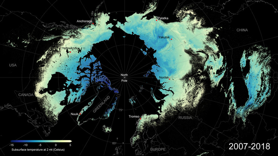
Frozen Arctic soils are set to release vast amounts of greenhouse gases to the atmosphere as they continue to thaw in coming decades. Despite concerns that this will fuel future global warming, the scale and speed of this important climate process remain uncertain. To help address this knowledge gap, ESA-funded researchers have developed and released a new permafrost dataset – the longest, satellite-derived permafrost record currently available.
End-Of-The-Year slevová
16.12.2020 9:52 Adeon![]() End-Of-The-Year slevová akce na nejoblíběnější produkty značky CGS.
End-Of-The-Year slevová akce na nejoblíběnější produkty značky CGS.
změna úředních hodin
16.12.2020 9:36 ČÚZK - předpisy a opatření Katastrální úřad pro Liberecký kraj zveřejnil novou aktualitu: Ve středu dne 23. 12. 2020 budou úřední hodiny katastrálního úřadu a všech jeho pracovišť od 8 do 15 hodin. Děkujeme za pochopení.změna úředních hodin
16.12.2020 9:36 ČÚZK /Urady/Katastralni-urady/Katastralni-urady/Katastralni-urad-pro-Liberecky-kraj/O-uradu/Aktuality/zmena-urednich-hodin-(3)ÚH 23.12.2020
16.12.2020 8:59 ČÚZK - předpisy a opatření Katastrální úřad pro Jihočeský kraj zveřejnil novou aktualitu: UPOZORNĚNÍVe středu dne 23.12.2020 budou na všech katastrálních pracovištích Katastrálního úřadu pro Jihočeský kraj úřední hodiny v omezeném rozsahu od 8 do 14 hodin.
ÚH 23.12.2020
16.12.2020 8:59 ČÚZK /Urady/Katastralni-urady/Katastralni-urady/Katastralni-urad-pro-Jihocesky-kraj/O-uradu/Aktuality/UH-23-12-2020Upozornění
16.12.2020 8:30 ČÚZK /Urady/Katastralni-urady/Katastralni-urady/Katastralni-urad-pro-Plzensky-kraj/O-uradu/Aktuality/Upozorneni-(2)Upozornění
16.12.2020 8:30 ČÚZK - předpisy a opatření Katastrální úřad pro Plzeňský kraj zveřejnil novou aktualitu: Katastrální úřad pro Plzeňský kraj od 21. 12. 2020 upravuje úřední hodiny katastrálních pracovišť.Ušetřete 20% na AutoCADu, AutoCADu LT a Revitu LT
16.12.2020 1:00 CAD Studio Ušetřete 20 % na Vašem novém CAD/BIM software - platí jen 2 dny, do 17.12. Váš nový CAD či BIM software Autodesk si nyní můžete pořídit levněji. V rámci krátké 2denní slevové promo akce můžete zakoupit o 20 % zvýhodněné 3leté subscription licence ...Autodesk ohlásil již tra
16.12.2020 0:00 Adeon Autodesk ohlásil již tradiční časově omezenou slevu až 20% na vybrané CAD produkty.
Knihovna geografie o vánočních prázdninách [Knihovna geografie, byTopic]
16.12.2020 0:00 Katedra aplikované geoinformatiky a kartografie Přf UK V období od 21.12.2020 do 1.1.2021 bude knihovna zcela uzavřena.Doubravice nad Svitavou a Kuničky se pyšní novou polní cestou
16.12.2020 0:00 Státní pozemkový úřad Pobočka Blansko Krajského pozemkového úřadu pro Jihomoravský kraj v roce 2020 dokončila stavbu polních cest s příkopy a rigoly v katastrálních územích Doubravice nad Svitavou a Kuničky.Swift Navigation Introduces a PCIe Product to Bring High-Precision GNSS to Industrial, Last-Mile and IoT Platforms
15.12.2020 20:24 GISCafe.com Webcasts-Webinars SAN FRANCISCO, Dec. 15, 2020 (GLOBE NEWSWIRE) -- Swift Navigation, a San Francisco-based tech firm redefining GNSS (Global Navigation Satellite …Bentley Systems Becomes Founding Member of Digital Twin Consortium
15.12.2020 17:39 Bentley Systems Deepens Collaboration with Industry, Government and Academic Members to Advance Interoperability of Digital TwinsEXTON, Pa. – December 15, 2020 – Bentley Systems, Incorporated (Nasdaq: BSY), the infrastructure engineering software company, has elevated its participation in the Digital Twin Consortium by becoming a founding member. Having been a groundbreaker member since day one of the consortium’s launch in May of 2020, Bentley will deepen its collaboration as a founding member and become a member of its steering committee.
Defining Digital Twins
One way that Bentley is helping advance the Digital Twin Consortium’s mission is through defining the terminology used to describe digital twins. Casey Mullen, distinguished architect, strategic technologies at Bentley Systems, has contributed his expertise as a lead author of the Digital Twin Consortium’s definition of a digital twin. Mullen helped unveil the new definition during a panel discussion at the IOT Solutions World Congress on December 3, 2020.
The consortium’s digital twin definition is:
A digital twin is a virtual representation of real-world entities and processes, synchronized at a specified frequency and fidelity.
- Digital twin systems transform business by accelerating holistic understanding, optimal decision-making, and effective action.
- Digital twins use real-time and historical data to represent the past and present and simulate predicted futures.
- Digital twins are motivated by outcomes, tailored to use cases, powered by integration, built on data, guided by domain knowledge, and implemented in IT/OT systems.
“I’ve enjoyed collaborating with representatives from diverse industries in the consortium’s Technology, Terminology, and Taxonomy Working Group to develop a set of practical definitions to inform those who are acquiring or implementing digital twins,” said Mullen.
Steering the WayAs a founding member, Bentley is also contributing its advice and technology expertise to the Digital Twin Consortium’s steering committee. Adam Klatzkin, vice president, iTwin Platform, at Bentley Systems, and Mullen are helping advance the Digital Twin Consortium’s strategic roadmap, working groups, and governance as members of the consortium’s steering committee.
“We are delighted that Bentley is a founding member of Digital Twin Consortium and is also a member of our steering committee,” said Dr. Richard Soley, executive director, Digital Twin Consortium. “The consortium looks forward to high-level guidance on digital twin technologies and continued contributions based on Bentley’s experience and knowledge of the infrastructure industry.”
An Open Platform for Digital Twins
Bentley’s collaboration with Digital Twin Consortium and its global ecosystem of digital twin users underscores its commitment to advancing open solutions for digital twins. Bentley provides iTwin.js, an open-source, software developer library for creating digital twin solutions for infrastructure. Bentley is also a member of buildingSMART International’s Digital Twin Working Group.
Bentley recently expanded its digital twin offerings with the iTwin Platform, a new platform-as-a-service offering for developers with openness as a guiding principle. The platform supports a broad range of design tools—Bentley and third-party—and file interchange formats including IFC. Klatzkin said, “The iTwin platform provides an open foundation for creating digital twin capabilities for modeling, simulation, project delivery, asset performance, and much more.”
To jump-start awareness and adoption of the iTwin digital twin platform, Bentley recently launched the iTwin Partner Program, the iTwin Ventures Fund, and hosted the inaugural iTwin Developer Conference.

Caption: As a founding member, Bentley will help advance the consortium’s strategic roadmap, working groups, and governance to maximize the benefits of digital twins and accelerate the digital twin market.
Digital Twin Consortium was formed by non-profit trade association Object Management Group® with Ansys, Dell, Lendlease, and Microsoft, to demonstrate the value of digital twin technology and accelerate the digital twin market. As the authority in digital twins, the consortium brings together industry, government, and academia to drive consistency in the vocabulary, architecture, security, and interoperability of digital twin technology. Digital Twin Consortium aims to influence the direction of digital twin technology development, become the focal point for digital twin thought leadership, and promote, evolve, and refine digital twin best practices and benefits.
About Digital Twin ConsortiumDigital Twin Consortium is The Authority in Digital Twin. It coalesces industry, government and academia to drive consistency in vocabulary, architecture, security and interoperability of digital twin technology. It advances the use of digital twin technology from aerospace to natural resources. Digital Twin Consortium is a program of Object Management Group.
www.digitaltwinconsortium.orgAbout Bentley Systems
Bentley Systems (Nasdaq: BSY) is the infrastructure engineering software company. We provide innovative software to advance the world’s infrastructure – sustaining both the global economy and environment. Our industry-leading software solutions are used by professionals, and organizations of every size, for the design, construction, and operations of roads and bridges, rail and transit, water and wastewater, public works and utilities, buildings and campuses, and industrial facilities. Our offerings include MicroStation-based applications for modeling and simulation, ProjectWise for project delivery, AssetWise for asset and network performance, and the iTwin platform for infrastructure digital twins. Bentley Systems employs more than 4,000 colleagues and generates annual revenues of more than $700 million, in 172 countries.
www.bentley.com© 2020 Bentley Systems, Incorporated. Bentley, the Bentley logo, AssetWise, iTwin, iTwin.js, MicroStation, and ProjectWise are either registered or unregistered trademarks or service marks of Bentley Systems, Incorporated or one of its direct or indirect wholly owned subsidiaries. All other brands and product names are trademarks of their respective owners.
Bentley Systems Becomes Founding Member of Digital Twin Consortium
15.12.2020 17:39 Bentley Systems Deepens Collaboration with Industry, Government and Academic Members to Advance Interoperability of Digital TwinsEXTON, Pa. – December 15, 2020 – Bentley Systems, Incorporated (Nasdaq: BSY), the infrastructure engineering software company, has elevated its participation in the Digital Twin Consortium by becoming a founding member. Having been a groundbreaker member since day one of the consortium’s launch in May of 2020, Bentley will deepen its collaboration as a founding member and become a member of its steering committee.
Defining Digital Twins
One way that Bentley is helping advance the Digital Twin Consortium’s mission is through defining the terminology used to describe digital twins. Casey Mullen, distinguished architect, strategic technologies at Bentley Systems, has contributed his expertise as a lead author of the Digital Twin Consortium’s definition of a digital twin. Mullen helped unveil the new definition during a panel discussion at the IOT Solutions World Congress on December 3, 2020.
The consortium’s digital twin definition is:
A digital twin is a virtual representation of real-world entities and processes, synchronized at a specified frequency and fidelity.
- Digital twin systems transform business by accelerating holistic understanding, optimal decision-making, and effective action.
- Digital twins use real-time and historical data to represent the past and present and simulate predicted futures.
- Digital twins are motivated by outcomes, tailored to use cases, powered by integration, built on data, guided by domain knowledge, and implemented in IT/OT systems.
“I’ve enjoyed collaborating with representatives from diverse industries in the consortium’s Technology, Terminology, and Taxonomy Working Group to develop a set of practical definitions to inform those who are acquiring or implementing digital twins,” said Mullen.
Steering the WayAs a founding member, Bentley is also contributing its advice and technology expertise to the Digital Twin Consortium’s steering committee. Adam Klatzkin, vice president, iTwin Platform, at Bentley Systems, and Mullen are helping advance the Digital Twin Consortium’s strategic roadmap, working groups, and governance as members of the consortium’s steering committee.
“We are delighted that Bentley is a founding member of Digital Twin Consortium and is also a member of our steering committee,” said Dr. Richard Soley, executive director, Digital Twin Consortium. “The consortium looks forward to high-level guidance on digital twin technologies and continued contributions based on Bentley’s experience and knowledge of the infrastructure industry.”
An Open Platform for Digital Twins
Bentley’s collaboration with Digital Twin Consortium and its global ecosystem of digital twin users underscores its commitment to advancing open solutions for digital twins. Bentley provides iTwin.js, an open-source, software developer library for creating digital twin solutions for infrastructure. Bentley is also a member of buildingSMART International’s Digital Twin Working Group.
Bentley recently expanded its digital twin offerings with the iTwin Platform, a new platform-as-a-service offering for developers with openness as a guiding principle. The platform supports a broad range of design tools—Bentley and third-party—and file interchange formats including IFC. Klatzkin said, “The iTwin platform provides an open foundation for creating digital twin capabilities for modeling, simulation, project delivery, asset performance, and much more.”
To jump-start awareness and adoption of the iTwin digital twin platform, Bentley recently launched the iTwin Partner Program, the iTwin Ventures Fund, and hosted the inaugural iTwin Developer Conference.
Digital Twin Consortium was formed by non-profit trade association Object Management Group® with Ansys, Dell, Lendlease, and Microsoft, to demonstrate the value of digital twin technology and accelerate the digital twin market. As the authority in digital twins, the consortium brings together industry, government, and academia to drive consistency in the vocabulary, architecture, security, and interoperability of digital twin technology. Digital Twin Consortium aims to influence the direction of digital twin technology development, become the focal point for digital twin thought leadership, and promote, evolve, and refine digital twin best practices and benefits.
About Digital Twin ConsortiumDigital Twin Consortium is The Authority in Digital Twin. It coalesces industry, government and academia to drive consistency in vocabulary, architecture, security and interoperability of digital twin technology. It advances the use of digital twin technology from aerospace to natural resources. Digital Twin Consortium is a program of Object Management Group.
www.digitaltwinconsortium.orgAbout Bentley Systems
Bentley Systems (Nasdaq: BSY) is the infrastructure engineering software company. We provide innovative software to advance the world’s infrastructure – sustaining both the global economy and environment. Our industry-leading software solutions are used by professionals, and organizations of every size, for the design, construction, and operations of roads and bridges, rail and transit, water and wastewater, public works and utilities, buildings and campuses, and industrial facilities. Our offerings include MicroStation-based applications for modeling and simulation, ProjectWise for project delivery, AssetWise for asset and network performance, and the iTwin platform for infrastructure digital twins. Bentley Systems employs more than 4,000 colleagues and generates annual revenues of more than $700 million, in 172 countries.
www.bentley.com© 2020 Bentley Systems, Incorporated. Bentley, the Bentley logo, AssetWise, iTwin, iTwin.js, MicroStation, and ProjectWise are either registered or unregistered trademarks or service marks of Bentley Systems, Incorporated or one of its direct or indirect wholly owned subsidiaries. All other brands and product names are trademarks of their respective owners.
GIS města Brna slaví 15 let!
15.12.2020 17:22 T-MAPYThe post GIS města Brna slaví 15 let! appeared first on T-MAPY spol. s r.o..
Utilis 2020 message to customers and partners on results and the future
15.12.2020 16:48 GISCafe.com Webcasts-Webinars Utilis to finish year at 150% YOY revenuesSAN DIEGO, Dec. 15, 2020 — (PRNewswire) —
SAN DIEGO, Dec. 15, 2020 /PRNewswire-PRWeb/ …
DJI's New Mavic 2 Enterprise Advanced Offers Improved Thermal Vision And Accuracy For Critical Drone Operations
15.12.2020 16:47 GISCafe.com Webcasts-Webinars Powerful Thermal And Visual Sensors, Highly Accurate RTK Technology And A 32 X Digital Zoom Make The New Addition To DJI's Commercial Fleet The Most …Use of GIS Improves Construction Projects and Strengthens Business for Design and Construction Companies
15.12.2020 16:47 GISCafe.com Webcasts-Webinars New study reveals important benefits that GIS provides to the industry, such as improved productivity and client satisfaction, plus fewer …Esri Releases Annual Update of Ready-to-Use US Census Bureau Data for ArcGIS Users
15.12.2020 16:47 GISCafe.com Webcasts-Webinars New American Community Survey Data Will Be Accessible in ArcGIS Living AtlasREDLANDS, Calif. — (BUSINESS WIRE) — December 15, 2020 …
St. Louis Geospatial Technology Accelerator Seeks Applications for Inaugural Cohort
15.12.2020 16:47 GISCafe.com Webcasts-Webinars NGA Accelerator Powered by Capital Innovators will accept applications until midnight Jan. 17ST. LOUIS, Dec. 15, 2020 — (PRNewswire) — …
Galileo enhancing Sentinel-6’s sea level monitoring mission
15.12.2020 15:25 ESA Navigation
Just like your mobile phone, satellites themselves rely on satellite navigation to find their way in space. Thanks to a new ESA-developed receiver, the recently-launched Sentinel-6 is making use of Europe’s Galileo as well as the US GPS system, a fact set to sharpen the accuracy of its sea level rise measurements.
Obmedzenia pri poskytovaní služieb na OÚ Rožňava a Komárno
15.12.2020 14:55
ÚGKK SR
Obmedzenia pri poskytovaní služieb na OÚ Rožňava a Komárno spôsobené personálnym výpadkom niektorých zamestnancov v súvislosti s ochorením na Covid-19.
OÚ Rožňava – agenda katastra
Bude fungovať len podateľňa, a to v obmedzenom režime.
OÚ Komárno – agenda katastra
Oznámenie o skrátení úradných hodín od 8:00 do 12:00 pre všetky pracovné dni až do odvolania.
APG se účastnila ISSS Digital 2020
15.12.2020 12:00 Komora geodetů a kartografů ČR S ohledem na situaci spojenou s covid-19 museli letos pořadatelé přesunout konferenci ISSS do online podoby. Začátkem prosince se uskutečnilo setkání věnované tématu Digitalizace stavebního řízení a územního plánování. Této moderované diskuze se zúčastnili Martin Kupka (místopředseda výboru pro veřejnou správu a místní rozvoj, PS PČR), Stanislav Bogdanov (ředitel odboru národních a EU informačních systémů, MMR ČR), Zdeněk Zajíček […]Rada/odborný rada - vedoucí oddělení aktualizace KN na Katastrálním pracovišti Kyjov
15.12.2020 11:16 ČÚZK - předpisy a opatření Katastrální úřad pro Jihomoravský kraj Katastrální pracoviště Kyjovvypisuje výběrové řízení na místo
Rada/odborný rada - vedoucí oddělení aktualizace KN na Katastrálním pracovišti Kyjov
Rada/odborný rada - vedoucí oddělení aktualizace KN na Katastrálním pracovišti Kyjov
15.12.2020 11:16 ČÚZK /Urady/Katastralni-urady/Katastralni-urady/Katastralni-urad-pro-Jihomoravsky-kraj/Uredni-deska/Oznameni-a-jina-uredni-sdeleni/Volna-mista/DMS/Rada-odborny-rada-vedouci-oddeleni-aktualizace-KRada/odborný rada - vedoucí oddělení aktualizace KN na Katastrálním pracovišti Kyjov
15.12.2020 11:16 ČÚZK - volná místa Katastrální úřad pro Jihomoravský kraj Katastrální pracoviště Kyjov vypisuje výběrové řízení na místo Rada/odborný rada - vedoucí oddělení aktualizace KN na Katastrálním pracovišti KyjovTiming is everything – GNSS and the energy grids of the future
15.12.2020 10:22 European GNSS Agency
In the smart energy grids of the future, all energy market participants will communicate with each other, making energy supplies more reactive. This will bring many benefits, including reduced costs, improved efficiency and the seamless integration of the distribution of energy sources, including renewable energy. However, for smart grids to operate successfully they will have to be based on a solid and robust synchronisation infrastructure. This is where GNSS comes in.
Grid systems rely on GNSS clocks as a time reference source and atomic clocks as a backup in case of outages. GNSS receivers are comparably low-cost, reliable, high-precision timing sources that can be implemented in a large number in intelligent grids, to enable real-time automatic control of the grid.
“Due to the importance of the power system to our lives and economies, and the likelihood of future smart grid reliance on high-precision timing, it is critical that GNSS signals be resilient against interference, including spoofing,” said GSA Executive Director da Costa. “The accuracy and robustness of the Galileo service, and the added layer of protection offered by the Open Service Navigation Message Authentication, means that Galileo will be the go-to solution for grid operators,” he said.
Galileo time
Two projects currently developing Galileo-enabled timing receivers, supported by the GSA through its Fundamental Elements funding programme, are GIANO and GEARS. Both receivers will make critical infrastructure and in particular the energy networks more robust against spoofing and will provide accurate Galileo-based timing and synchronisation capabilities.
Read this: Galileo for Timing and Synchronisation Applications
“The Galileo programme is slowly becoming the EU’s official time reference that, together with national UTC(k) network time distribution, creates new powerful and robust synchronisation references for smart-grids,” said Tomasz Widomski, a member of the supervisory board of ELPROMA, a Polish manufacturer of NTP/PTP time servers.
“It is believed that the power industry evolving towards smart grids will rely on this solid foundation of timing information. The main and regional systems must be tamper-proof and protected against external interferences – the time and synchronisation must be safe,” he said.
Horizon 2020 success story
ELPROMA was a member of the Horizon 2020 ‘DEMonstrator of EGNSS services based on Time Reference Architecture’ (Demetra) project, which developed a prototype of an EGNSS-based time disseminator that provides time certification, redundancy, resilience, integrity and improved accuracy, while validating the concept of ‘time as a service’.
And this: Galileo-inspired opportunities for critical infrastructures presented at ITSF 2020
The company went on to win a seven-figure contract to supply Rubidium IEEE1588 NTS-5000 servers to support a country-scale modern smart grid system in Asia (read more here). These servers incorporate a modified version of the cyber-security solution developed as part of the Demetra project. As such, this is a Horizon 2020 success story.
Media note: This feature can be republished without charge provided the European GNSS Agency (GSA) is acknowledged as the source at the top or the bottom of the story. You must request permission before you use any of the photographs on the site. If you republish, we would be grateful if you could link back to the GSA website (http://www.gsa.europa.eu).
Timing is everything – GNSS and the energy grids of the future
15.12.2020 10:22 European GNSS AgencyIn the smart energy grids of the future, all energy market participants will communicate with each other, making energy supplies more reactive. This will bring many benefits, including reduced costs, improved efficiency and the seamless integration of the distribution of energy sources, including renewable energy. However, for smart grids to operate successfully they will have to be based on a solid and robust synchronisation infrastructure. This is where GNSS comes in.
Grid systems rely on GNSS clocks as a time reference source and atomic clocks as a backup in case of outages. GNSS receivers are comparably low-cost, reliable, high-precision timing sources that can be implemented in a large number in intelligent grids, to enable real-time automatic control of the grid.
“Due to the importance of the power system to our lives and economies, and the likelihood of future smart grid reliance on high-precision timing, it is critical that GNSS signals be resilient against interference,” said GSA Executive Director da Costa. “The accuracy and robustness of the Galileo service, and the added layer of protection that will be offered by the Open Service Navigation Message Authentication, means that Galileo will be the go-to solution for grid operators,” he said.
Galileo time
Two projects currently developing Galileo-enabled timing receivers, supported by the GSA through its Fundamental Elements funding programme, are GIANO and GEARS. Both receivers will make critical infrastructure and in particular the energy networks more robust against spoofing and will provide accurate Galileo-based timing and synchronisation capabilities.
Read this: Galileo for Timing and Synchronisation Applications
“The Galileo programme is slowly becoming the EU’s official time reference that, together with national UTC(k) network time distribution, creates new powerful and robust synchronisation references for smart-grids,” said Tomasz Widomski, a member of the supervisory board of ELPROMA, a Polish manufacturer of NTP/PTP time servers.
“It is believed that the power industry evolving towards smart grids will rely on this solid foundation of timing information. The main and regional systems must be tamper-proof and protected against external interferences – the time and synchronisation must be safe,” he said.
Horizon 2020 success story
ELPROMA was a member of the Horizon 2020 ‘DEMonstrator of EGNSS services based on Time Reference Architecture’ (Demetra) project, which developed a prototype of an EGNSS-based time disseminator that provides time certification, redundancy, resilience, integrity and improved accuracy, while validating the concept of ‘time as a service’.
And this: Galileo-inspired opportunities for critical infrastructures presented at ITSF 2020
The company went on to win a seven-figure contract to supply Rubidium IEEE1588 NTS-5000 servers to support a country-scale modern smart grid system in Asia (read more here). These servers incorporate a modified version of the cyber-security solution developed as part of the Demetra project. As such, this is a Horizon 2020 success story.
Media note: This feature can be republished without charge provided the European GNSS Agency (GSA) is acknowledged as the source at the top or the bottom of the story. You must request permission before you use any of the photographs on the site. If you republish, we would be grateful if you could link back to the GSA website (http://www.gsa.europa.eu).
Vánoční mapová hra od Mapy.cz
15.12.2020 9:22 GISportal.cz
U příležitosti Vánoc 2020 pro vás na Mapy.cz připravili malou hru. Zkuste, jestli dokážete získat od zlého čaroděje ukradenou Vánoční hvězdu a zachránit tak nejen Vánoce, ale i celé království. Hra začíná u Královského bubeníka. Pokud jste náhodou objevili nějakou jinou postavu ze hry, začněte raději od začátku a běžte se pobavit s bubeníkem. Při hraní […]
The post Vánoční mapová hra od Mapy.cz appeared first on GISportal.cz.
Mapová aplikace ÚPD - nové dokumentace
15.12.2020 8:20 Jihočeský kraj V mapové aplikaci Územně plánovací dokumentace obcí byla aktualizována ÚPD obcí ORP České Budějovice – Římov, Homole, ORP Týn nad Vltavou – Dražíč, ORP Strakonice – Horní Poříčí, ORP Vodňany – Chelčice, ORP Český Krumlov – SrnínGeomatik bude správcem digitálního dvojčete po celou dobu životního cyklu stavby
15.12.2020 6:51 ZeměměřičLetošní virtuální konference ISSS 2020 je plná moderovaných diskuzí, věnovaných například eIdentitě nebo digitalizaci stavebního řízení a územního plánování. V programu konference naleznete také představení aktuálního vývoje kolem Digitální technické mapy ČR v podání vedoucích představitelů Asociace podnikatelů v geomatice. Martin Hrdlička a Jiří Bradáč vysvětlují, k čemu DTM ČR bude sloužit, jaká data se budou sbírat, kolik financí je […]
The post Geomatik bude správcem digitálního dvojčete po celou dobu životního cyklu stavby appeared first on Zeměměřič.
Geomatik bude správcem digitálního dvojčete po celou dobu životního cyklu stavby
15.12.2020 6:51 ZeměměřičLetošní virtuální konference ISSS 2020 je plná moderovaných diskuzí, věnovaných například eIdentitě nebo digitalizaci stavebního řízení a územního plánování. V programu konference naleznete také představení aktuálního vývoje kolem Digitální technické mapy ČR v podání vedoucích představitelů Asociace podnikatelů v geomatice. Martin Hrdlička a Jiří Bradáč vysvětlují, k čemu DTM ČR bude sloužit, jaká data se budou sbírat, kolik financí je […]
The post Geomatik bude správcem digitálního dvojčete po celou dobu životního cyklu stavby appeared first on Zeměměřič.
[Webinar Recording] Satsurv in Civil Engineering
15.12.2020 4:38 Satlab Geosolutions Common information checking and setting tips[Webinar Recording] Satsurv in Civil Engineering
15.12.2020 4:38 Satlab Geosolutions Common information checking and setting tips[Webinar Recording] Satsurv in Civil Engineering
15.12.2020 4:38 Satlab GeosolutionsCommon information checking and setting tips
The post [Webinar Recording] Satsurv in Civil Engineering appeared first on Global Satellite Positioning Singapore | SatLab Geosolutions AB.
[Webinar Recording] Satsurv in Civil Engineering
15.12.2020 4:38 Satlab GeosolutionsCommon information checking and setting tips
The post [Webinar Recording] Satsurv in Civil Engineering appeared first on Global Satellite Positioning Solutions | SatLab Geosolutions AB.
APGEO - APG se zúčastnilo ISSS Digital 2020
15.12.2020 1:00 Asociace podnikatelů v geomatice S ohledem na situaci spojenou s covid-19 museli letos pořadatelé přesunout konferenci ISSS do online podoby.OGC zve k připomínkám třetí verze konceptuálního modelu CityGML, používaného pro 3D modely
14.12.2020 23:23 GeoBusinessSdružení Open Geospatial vyzvalo k veřejným připomínkám třetí verze konceptuálního modelu CityGML. Tento jazyk se používá pro tvorbu 3D modelů měst. Rozvoj jazyka CityGML je důležitý zejména kvůli trendu s 3D modelováním pro BIM a tzv. digitální dvojčata, možnostmi budoucích 3D vizualizací v rozšířené realitě či vizualizacemi technické infrastruktury například pro Digitální technickou mapu ČR. […]
The post OGC zve k připomínkám třetí verze konceptuálního modelu CityGML, používaného pro 3D modely appeared first on GeoBusiness.
Public comment sought on CityGML 3.0 Conceptual Model for storage and exchange of 3D city models
14.12.2020 22:25 GISCafe.com Webcasts-Webinars CityGML 3.0 defines a common information model for the representation of 3D urban objects that can be shared over different applications, improving …Robotic Skies Raises New Investment to Grow Drone Support Services
14.12.2020 20:39 GISCafe.com Webcasts-Webinars Robotic Skies, Inc, the first and only global maintenance marketplace for commercial Unmanned Aircraft Systems (UAS), announced today a new round of …odborný referent / vrchní referent v oddělení aktualizace a dokumentace Katastrálního pracoviště Nác
14.12.2020 16:31 ČÚZK - volná místa Katastrální úřad pro Královéhradecký kraj - Katastrální pracoviště Náchod vypisuje výběrové řízení na místo odborný referent / vrchní referent v oddělení aktualizace a dokumentace Katastrálního pracoviště Nácodborný referent / vrchní referent v oddělení aktualizace a dokumentace Katastrálního pracoviště Nác
14.12.2020 16:31 ČÚZK /Urady/Katastralni-urady/Katastralni-urady/Katastralni-urad-pro-Kralovehradecky-kraj/Uredni-deska/Oznameni-a-jina-uredni-sdeleni/Volna-mista/odborny-referent-vrchni-referent-v-oddeleni-ak-(1)odborný referent / vrchní referent v oddělení aktualizace a dokumentace Katastrálního pracoviště Nác
14.12.2020 16:31 ČÚZK - předpisy a opatření Katastrální úřad pro Královéhradecký kraj - Katastrální pracoviště Náchodvypisuje výběrové řízení na místo
odborný referent / vrchní referent v oddělení aktualizace a dokumentace Katastrálního pracoviště Náchod
Kleos Space Opens U.S. Engineering Office in Denver Colorado
14.12.2020 16:28 GISCafe.com Webcasts-Webinars December 14, 2020 -- Luxembourg/ Denver (U.S.) - Kleos Space S.A. (ASX: KSS, Frankfurt: KS1,) a space-powered Radio Frequency Reconnaissance …NV5 Awarded $13 Million in North Carolina Department of Transportation Contracts
14.12.2020 16:28 GISCafe.com Webcasts-Webinars HOLLYWOOD, Fla., Dec. 14, 2020 (GLOBE NEWSWIRE) -- NV5 Global, Inc. (the “Company” or “NV5”) (Nasdaq: NVEE), a provider of compliance, …Quantum Acquires Square Box Systems Ltd, Maker of CatDV, to Help Businesses Get More Value from Unstructured Data
14.12.2020 16:28 GISCafe.com Webcasts-Webinars Acquisition Adds Data Cataloging, AI Analytics and Automation Software for Data Enrichment and OrchestrationSAN JOSE, Calif., Dec. 14, 2020 — …
Obmedzenia pri poskytovaní služieb na OÚ Rožňava a Komárno
14.12.2020 16:25
ÚGKK SR
Obmedzenia pri poskytovaní služieb na OÚ Rožňava a Komárno spôsobené personálnym výpadkom niektorých zamestnancov v súvislosti s ochorením na Covid-19.
OÚ Rožňava – agenda katastra
Bude fungovať len podateľňa, a to v obmedzenom režime.
OÚ Komárno – agenda katastra
Bude fungovať len podateľňa, a to v obmedzenom režime.
rada/odborný rada – inspektor Zeměměřického a katastrálního inspektorátu v Pardubicích
14.12.2020 15:59 ČÚZK - předpisy a opatření Zeměměřický a katastrální inspektorát v Pardubicíchvypisuje výběrové řízení na místo
rada/odborný rada – inspektor Zeměměřického a katastrálního inspektorátu v Pardubicích
rada/odborný rada – inspektor Zeměměřického a katastrálního inspektorátu v Pardubicích
14.12.2020 15:59 ČÚZK /Urady/Zememericke-a-katastralni-inspektoraty/Zememericke-a-katastralni-inspektoraty/Zememericky-a-katastralni-inspektorat-v-Pardubicic/Uredni-deska/Oznameni-a-jina-uredni-sdeleni/Volna-mista/DMS/rada-odborny-rada-–-inspektor-Zememerickeho-a-katarada/odborný rada – inspektor Zeměměřického a katastrálního inspektorátu v Pardubicích
14.12.2020 15:59 ČÚZK - volná místa Zeměměřický a katastrální inspektorát v Pardubicích vypisuje výběrové řízení na místo rada/odborný rada – inspektor Zeměměřického a katastrálního inspektorátu v PardubicíchArcGIS Experience Builder
14.12.2020 14:24 blog ARCDATA Novým moderním nástrojem pro budování webových aplikací je na platformě Esri ArcGIS Experience Builder. Proč tu máme další „builder“? Jaké jsou jeho přednosti? Bude starý známý Web AppBuilder nahrazen? Odpovědi na tyto i další otázky naleznete v tomto článku.ISSS 2020 – Digitalizace stavebního řízení a územního plánování
14.12.2020 13:58 ZeměměřičLetoční ročník konference ISSS, která se v předchozích letech vždy konala v dubnu v Hradci Králové, letos organizátoři museli přesunout do online podoby. Jedna z diskuzních debat je věnována digitalizaci stavebního řízení a územního plánování. V moderované diskuzi, která se týká připravovaného Portálu stavebníka, jednotlivých datových úložišť, nového geoportálu, vystupují Martin Kupka (místopředseda Výboru pro veřejnou správu a místní rozvoj, Poslanecká […]
The post ISSS 2020 – Digitalizace stavebního řízení a územního plánování appeared first on Zeměměřič.
ISSS 2020 – Digitalizace stavebního řízení a územního plánování
14.12.2020 13:58 ZeměměřičLetoční ročník konference ISSS, která se v předchozích letech vždy konala v dubnu v Hradci Králové, letos organizátoři museli přesunout do online podoby. Jedna z diskuzních debat je věnována digitalizaci stavebního řízení a územního plánování. V moderované diskuzi vystupují Martin Kupka (místopředseda Výboru pro veřejnou správu a místní rozvoj, Poslanecká sněmovna Parlamentu ČR), Stanislav Bogdanov (ředitel odboru národních a EU informačních systémů, […]
The post ISSS 2020 – Digitalizace stavebního řízení a územního plánování appeared first on Zeměměřič.
ISSS 2020 – Digitalizace stavebního řízení a územního plánování
14.12.2020 13:58 ZeměměřičLetoční ročník konference ISSS, která se v předchozích letech vždy konala v dubnu v Hradci Králové, letos organizátoři museli přesunout do online podoby. Jedna z diskuzních debat je věnována digitalizaci stavebního řízení a územního plánování. V moderované diskuzi, která se týká připravovaného Portálu stavebníka, jednotlivých datových úložišť, nového geoportálu, vystupují Martin Kupka (místopředseda Výboru pro veřejnou správu a místní rozvoj, Poslanecká […]
The post ISSS 2020 – Digitalizace stavebního řízení a územního plánování appeared first on Zeměměřič.
CryoSat reveals surprising ebb and flow of subglacial lakes
14.12.2020 13:50 ESA Observing the Earth
Hidden from view by ice kilometres thick, there is a vast network of lakes and streams at the base of the Antarctic ice sheet. This subsurface meltwater affects the speed with which the ice sheet flows towards the ocean. Using a decade of altimetry data from ESA’s CryoSat satellite, scientists have made an unexpected discovery about how lakes beneath Thwaites glacier have drained and recharged in quick succession.
CryoSat reveals surprising ebb and flow of subglacial lakes
14.12.2020 13:50 ESA Observing the Earth
Hidden from view by ice kilometres thick, there is a vast network of lakes and streams at the base of the Antarctic ice sheet. This subsurface meltwater affects the speed with which the ice sheet flows towards the ocean. Using a decade of altimetry data from ESA’s CryoSat satellite, scientists have made an unexpected discovery about how lakes beneath Thwaites glacier have drained and recharged in quick succession. Hidden from view by ice kilometres thick, there is a vast network of lakes and streams at the base of the Antarctic ice sheet.
Doktorské řízení - Olga Halásová
14.12.2020 11:30 Geografický ústav MUDne 14. 12. se na Geografickém ústavu koná státní doktorská zkouška a obhajoba disertační práce
Mgr. Olgy Halásové vypracované na téma "Přívalové povodně na Moravě a ve Slezsku v 19. a 20. století".
Jednání proběhne on-line a z veřejné části obhajoby bude pořízen záznam.
Let us have your feedback on Galileo/EGNOS – User satisfaction survey launched
14.12.2020 11:07 European GNSS Agency
The European GNSS Agency (GSA) is launching the 2020 editions of its Galileo User Satisfaction Survey and EGNOS User Satisfaction Survey. These surveys play an important role in the evolution of the EGNSS programmes by feeding users’ needs and requirements into programme development.
Our motto at the GSA is ‘linking space to user needs’ and these are not empty words – users have always been at the heart of Galileo and EGNOS service provision, and feedback from users on their experience of the programmes is invaluable in shaping our services, making sure that they develop in line with market needs and continue to meet user requirements in the best way possible.
A targeted approach
The Galileo and EGNOS User Satisfaction Surveys are addressing all users and market segments including.: Aviation, Maritime, Rail, Road, Location Based Services, Agriculture, Surveying and Mapping and LBS. When responding to the survey, select the market segment in which you operate; the market segment that corresponds to your main area of activity; or the market segment that is the most important for your company or organisation, if you are active in multiple market segments. The Galileo User Satisfaction survey is also looking for user feedback on the support provided to the users via the Galileo Service Center. You can access the Galileo survey here.
Take part to the Galileo survey here.
In addition to the various market segments, the EGNOS survey also covers all the EGNOS services, including the Open Service, the Safety of Life Service and the EGNOS Data Access Service (EDAS). It also assesses the EGNOS service provider’s management of EGNOS User Support Services. For the EGNOS survey, click here.
Take part to the EGNOS survey here.
The feedback was positive in the 2019 EGNOS User Satisfaction Survey, with a global user satisfaction score of 8.6 out of 10, up from 8.3 in the previous year. User satisfaction with EGNOS support was up across all the support services – the website, documentation and the helpdesk.
Based on the feedback, recommendations were drawn up for improvements across all the EGNOS services and support to users. For an overview of the results of the 2019 EGNOS User Satisfaction Survey and the recommendations it generated, click here. We strongly encourage Galileo or EGNOS users to take part in the survey and help us fine-tune our service provision. The more users respond, from all market segments, the better the GSA and the Galileo and EGNOS systems will be able to go on meeting the requirements of the entire user community. The surveys only takes a few minutes to complete and your feedback will make a real difference.
In the 2019 Galileo User Satisfaction Survey, we were pleased to see that overall satisfaction with the service was up from the previous year, with 94% of users satisfied with the service and 97% of users happy to recommend the service to others. Based on user feedback, a number of recommendations were drawn up to strengthen the GNSS Service Centre (GSC).
Media note: This feature can be republished without charge provided the European GNSS Agency (GSA) is acknowledged as the source at the top or the bottom of the story. You must request permission before you use any of the photographs on the site. If you republish, we would be grateful if you could link back to the GSA website (http://www.gsa.europa.eu).
Let us have your feedback on Galileo/EGNOS – User satisfaction survey launched
14.12.2020 11:07 European GNSS AgencyThe European GNSS Agency (GSA) is launching the 2020 editions of its Galileo User Satisfaction Survey and EGNOS User Satisfaction Survey. These surveys play an important role in the evolution of the EGNSS programmes by feeding users’ needs and requirements into programme development.
Our motto at the GSA is ‘linking space to user needs’ and these are not empty words – users have always been at the heart of Galileo and EGNOS service provision, and feedback from users on their experience of the programmes is invaluable in shaping our services, making sure that they develop in line with market needs and continue to meet user requirements in the best way possible.
A targeted approach
The Galileo and EGNOS User Satisfaction Surveys are addressing all users and market segments including.: Aviation, Maritime, Rail, Road, Location Based Services, Agriculture and Surveying and Mapping. When responding to the survey, select the market segment in which you operate; the market segment that corresponds to your main area of activity; or the market segment that is the most important for your company or organisation, if you are active in multiple market segments. The Galileo User Satisfaction survey is also looking for user feedback on the support provided to the users via the Galileo Service Center. You can access the Galileo survey here.
Take part in the Galileo survey here.
In addition to the various market segments, the EGNOS survey also covers all the EGNOS services, including the Open Service, the Safety of Life Service and the EGNOS Data Access Service (EDAS). It also assesses the EGNOS service provider’s management of EGNOS User Support Services. For the EGNOS survey, click here.
Take part in the EGNOS survey here.
The feedback was positive in the 2019 EGNOS User Satisfaction Survey, with a global user satisfaction score of 8.6 out of 10, up from 8.3 in the previous year. User satisfaction with EGNOS support was up across all the support services – the website, documentation and the helpdesk.
Based on the feedback, recommendations were drawn up for improvements across all the EGNOS services and support to users. For an overview of the results of the 2019 EGNOS User Satisfaction Survey and the recommendations it generated, click here. We strongly encourage Galileo or EGNOS users to take part in the survey and help us fine-tune our service provision. The more users respond, from all market segments, the better the GSA and the Galileo and EGNOS systems will be able to go on meeting the requirements of the entire user community. The surveys only takes a few minutes to complete and your feedback will make a real difference.
In the 2019 Galileo User Satisfaction Survey, we were pleased to see that overall satisfaction with the service was up from the previous year, with 94% of users satisfied with the service and 97% of users happy to recommend the service to others. Based on user feedback, a number of recommendations were drawn up to strengthen the GNSS Service Centre (GSC).
Media note: This feature can be republished without charge provided the European GNSS Agency (GSA) is acknowledged as the source at the top or the bottom of the story. You must request permission before you use any of the photographs on the site. If you republish, we would be grateful if you could link back to the GSA website (http://www.gsa.europa.eu).
Let us have your feedback on Galileo/EGNOS – User satisfaction survey launched
14.12.2020 11:07 European GNSS Agency
The European GNSS Agency (GSA) is launching the 2020 editions of its Galileo User Satisfaction Survey and EGNOS User Satisfaction Survey. These surveys play an important role in the evolution of the EGNSS programmes by feeding users’ needs and requirements into programme development.
Our motto at the GSA is ‘linking space to user needs’ and these are not empty words – users have always been at the heart of Galileo and EGNOS service provision, and feedback from users on their experience of the programmes is invaluable in shaping our services, making sure that they develop in line with market needs and continue to meet user requirements in the best way possible.
A targeted approach
The Galileo and EGNOS User Satisfaction Surveys are addressing all users and market segments including.: Aviation, Maritime, Rail, Road, Location Based Services, Agriculture, Surveying and Mapping and LBS. When responding to the survey, select the market segment in which you operate; the market segment that corresponds to your main area of activity; or the market segment that is the most important for your company or organisation, if you are active in multiple market segments. The Galileo User Satisfaction survey is also looking for user feedback on the support provided to the users via the Galileo Service Center. You can access the Galileo survey here.
Take part to the Galileo survey here.
In addition to the various market segments, the EGNOS survey also covers all the EGNOS services, including the Open Service, the Safety of Life Service and the EGNOS Data Access Service (EDAS). It also assesses the EGNOS service provider’s management of EGNOS User Support Services. For the EGNOS survey, click here.
Take part to the EGNOS survey here.
The feedback was positive in the 2019 EGNOS User Satisfaction Survey, with a global user satisfaction score of 8.6 out of 10, up from 8.3 in the previous year. User satisfaction with EGNOS support was up across all the support services – the website, documentation and the helpdesk.
Based on the feedback, recommendations were drawn up for improvements across all the EGNOS services and support to users. For an overview of the results of the 2019 EGNOS User Satisfaction Survey and the recommendations it generated, click here. We strongly encourage Galileo or EGNOS users to take part in the survey and help us fine-tune our service provision. The more users respond, from all market segments, the better the GSA and the Galileo and EGNOS systems will be able to go on meeting the requirements of the entire user community. The surveys only takes a few minutes to complete and your feedback will make a real difference.
In the 2019 Galileo User Satisfaction Survey, we were pleased to see that overall satisfaction with the service was up from the previous year, with 94% of users satisfied with the service and 97% of users happy to recommend the service to others. Based on user feedback, a number of recommendations were drawn up to strengthen the GNSS Service Centre (GSC).
Media note: This feature can be republished without charge provided the European GNSS Agency (GSA) is acknowledged as the source at the top or the bottom of the story. You must request permission before you use any of the photographs on the site. If you republish, we would be grateful if you could link back to the GSA website (http://www.gsa.europa.eu).
Let us have your feedback on Galileo/EGNOS – User satisfaction survey launched
14.12.2020 11:07 European GNSS AgencyThe European GNSS Agency (GSA) is launching the 2020 editions of its Galileo User Satisfaction Survey and EGNOS User Satisfaction Survey. These surveys play an important role in the evolution of the EGNSS programmes by feeding users’ needs and requirements into programme development.
Our motto at the GSA is ‘linking space to user needs’ and these are not empty words – users have always been at the heart of Galileo and EGNOS service provision, and feedback from users on their experience of the programmes is invaluable in shaping our services, making sure that they develop in line with market needs and continue to meet user requirements in the best way possible.
A targeted approach
The Galileo and EGNOS User Satisfaction Surveys are addressing all users and market segments including.: Aviation, Maritime, Rail, Road, Location Based Services, Agriculture, Surveying and Mapping and LBS. When responding to the survey, select the market segment in which you operate; the market segment that corresponds to your main area of activity; or the market segment that is the most important for your company or organisation, if you are active in multiple market segments. The Galileo User Satisfaction survey is also looking for user feedback on the support provided to the users via the Galileo Service Center. You can access the Galileo survey here.
Take part to the Galileo survey here.
In addition to the various market segments, the EGNOS survey also covers all the EGNOS services, including the Open Service, the Safety of Life Service and the EGNOS Data Access Service (EDAS). It also assesses the EGNOS service provider’s management of EGNOS User Support Services. For the EGNOS survey, click here.
Take part to the EGNOS survey here.
The feedback was positive in the 2019 EGNOS User Satisfaction Survey, with a global user satisfaction score of 8.6 out of 10, up from 8.3 in the previous year. User satisfaction with EGNOS support was up across all the support services – the website, documentation and the helpdesk.
Based on the feedback, recommendations were drawn up for improvements across all the EGNOS services and support to users. For an overview of the results of the 2019 EGNOS User Satisfaction Survey and the recommendations it generated, click here. We strongly encourage Galileo or EGNOS users to take part in the survey and help us fine-tune our service provision. The more users respond, from all market segments, the better the GSA and the Galileo and EGNOS systems will be able to go on meeting the requirements of the entire user community. The surveys only takes a few minutes to complete and your feedback will make a real difference.
In the 2019 Galileo User Satisfaction Survey, we were pleased to see that overall satisfaction with the service was up from the previous year, with 94% of users satisfied with the service and 97% of users happy to recommend the service to others. Based on user feedback, a number of recommendations were drawn up to strengthen the GNSS Service Centre (GSC).
Media note: This feature can be republished without charge provided the European GNSS Agency (GSA) is acknowledged as the source at the top or the bottom of the story. You must request permission before you use any of the photographs on the site. If you republish, we would be grateful if you could link back to the GSA website (http://www.gsa.europa.eu).
Aktualizace ISKN na verzi 5.5
14.12.2020 10:43 ARCDATAV souvislosti s dopadem Zákona č. 51/2020 Sb. o územně správním členění státu došlo v rámci instalace nové verze ISKN 9.1 ke změně ve struktuře výměnného formátu ISKN.
Nová verze nese označení VF ISKN 5.5 a od 7. 11. 2020 jsou všechny exporty vydávány právě v této v verzi. Tato změna byla promítnuta i do ISKN Studia tak, že byly vytvořeny nové šablony verze 5.5.
Taktéž je k dispozici i nová verze aplikace ISKN Studio 10.x.4, která podporuje aktuální, i starší verze systému ArcGIS. Více informací o funkcích a vlastnostech softwaru ISKN Studio naleznete na samostatné stránce.
Aktualizace IKSN na verzi 5.5
14.12.2020 10:43 ARCDATAV souvislosti s dopadem Zákona č. 51/2020 Sb. o územně správním členění státu dojde v rámci instalace nové verze ISKN 9.1 k příslušné změně ve struktuře výměnného formátu ISKN.
Nová verze nese označení VF ISKN 5.5 a od 7. 11. 2020 jsou všechny exporty vydávány právě v této v verzi.
Mapping high-resolution methane emissions from space
14.12.2020 9:51 ESA Observing the Earth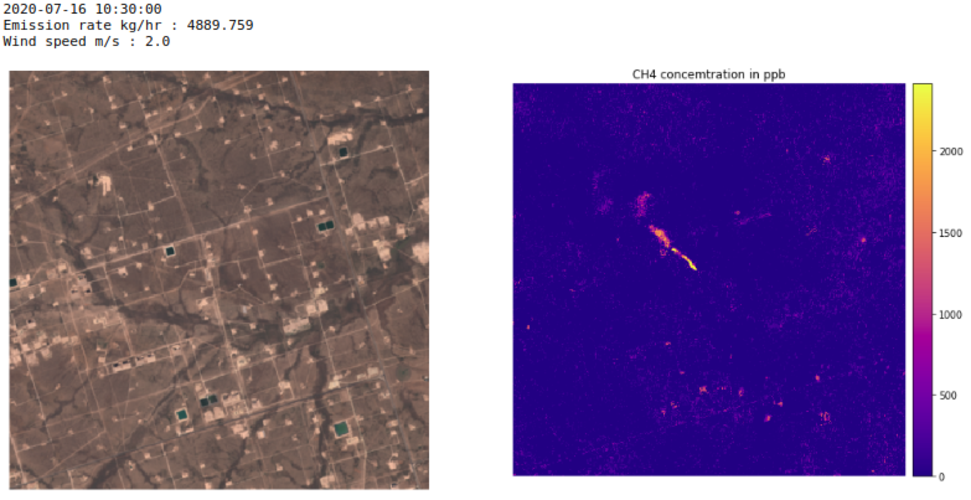
Scientists have used satellite data from the Copernicus Sentinel-2 mission, combined with the Sentinel-5P satellite, to detect individual methane emissions from space.
Upozornění
13.12.2020 11:12 ČÚZK - předpisy a opatření Zeměměřický a katastrální inspektorát v Plzni zveřejnil novou aktualitu: Zeměměřický a katastrální inspektorát v Plzni oznamuje, že s ohledem na opatření přijatá usnesením vlády ČR č. 1202 ze dne 20. listopadu 2020 má až do odvolání omezený provoz pro veřejnost.Upozornění
13.12.2020 11:12 ČÚZK /Urady/Zememericke-a-katastralni-inspektoraty/Zememericke-a-katastralni-inspektoraty/Zememericky-a-katastralni-inspektorat-v-Plzni/O-uradu/Aktuality/Upozorneni-(5)Innoviz Technologies, a Global Leader in LiDAR Sensors and Perception Software for Autonomous Driving, to be Listed on Nasdaq Through Business Combination with Collective Growth Corporation
11.12.2020 17:03 GISCafe.com Webcasts-Webinars - Innoviz Technologies Ltd. ("Innoviz") to become publicly listed through business combination with Collective Growth Corporation (NASDAQ: CGRO) …Kongsberg Geospatial Announces New Tactical UAS Sensor Data Management Solution
11.12.2020 17:03 GISCafe.com Webcasts-Webinars Kongsberg Geospatial MIDAS is a Processing, Exploitation and Dissemination (PED) Solution for rapid intelligence analysis of data from Tactical …Iceberg on collision course with South Georgia
11.12.2020 12:00 ESA Observing the Earth Video:
00:02:06
Video:
00:02:06
The giant A-68A iceberg could strike land this month – wreaking havoc near the waters of the South Georgia Island.
Since its ‘birth’ in 2017, the iceberg has travelled thousands of kilometres from the Larsen C ice shelf, in Antarctica, and now lies around 120 km from South Georgia. If it remains on its current path, the iceberg could ground in the shallow waters offshore – threatening wildlife, including penguins and seals.
Satellite missions are being used to track the berg on its journey over the past three years. The Copernicus Sentinel-1 radar mission, with its ability to see through clouds and the dark, has been instrumental in mapping the polar regions in winter.
Video credits:
Animation: contains modified Copernicus Sentinel data (2017-18), processed by Swansea University-A. Luckman
Radar images: contains modified Copernicus Sentinel data (2020), processed by ESA, CC BY-SA 3.0 IGO
A-68A map: contains modified Copernicus Sentinel data (2020), processed by ESA; Antarctic Iceberg Tracking Database
Sentinel-1 animations: ESA/ATG Medialab
Penguins footage: Getty
Iceberg on collision course with South Georgia
11.12.2020 12:00 ESA Observing the Earth
Video:
00:02:06
The giant A-68A iceberg could strike land this month – wreaking havoc near the waters of the South Georgia Island.
Since its ‘birth’ in 2017, the iceberg has travelled thousands of kilometres from the Larsen C ice shelf, in Antarctica, and now lies around 120 km from South Georgia. If it remains on its current path, the iceberg could ground in the shallow waters offshore – threatening wildlife, including penguins and seals.
Satellite missions are being used to track the berg on its journey over the past three years. The Copernicus Sentinel-1 radar mission, with its ability to see through clouds and the dark, has been instrumental in mapping the polar regions in winter.
Video credits:
Animation: contains modified Copernicus Sentinel data (2017-18), processed by Swansea University-A. Luckman
Radar images: contains modified Copernicus Sentinel data (2020), processed by ESA, CC BY-SA 3.0 IGO
A-68A map: contains modified Copernicus Sentinel data (2020), processed by ESA; Antarctic Iceberg Tracking Database
Sentinel-1 animations: ESA/ATG Medialab
Penguins footage: Getty
Iceberg on collision course with South Georgia
11.12.2020 12:00 ESA Observing the Earth
Video:
00:02:06
The giant A-68A iceberg could strike land this month – wreaking havoc near the waters of the South Georgia Island.
Since its ‘birth’ in 2017, the iceberg has travelled thousands of kilometres from the Larsen C ice shelf, in Antarctica, and now lies around 120 km from South Georgia. If it remains on its current path, the iceberg could ground in the shallow waters offshore – threatening wildlife, including penguins and seals.
Satellite missions are being used to track the berg on its journey over the past three years. The Copernicus Sentinel-1 radar mission, with its ability to see through clouds and the dark, has been instrumental in mapping the polar regions in winter.
Video credits:
Animation: contains modified Copernicus Sentinel data (2017-18), processed by Swansea University-A. Luckman
Radar images: contains modified Copernicus Sentinel data (2020), processed by ESA, CC BY-SA 3.0 IGO
A-68A map: contains modified Copernicus Sentinel data (2020), processed by ESA; Antarctic Iceberg Tracking Database
Sentinel-1 animations: ESA/ATG Medialab
Penguin footage: Getty Images
Odborný referent / vrchní referent v oddělení dokumentace Katastrálního pracoviště Rychnov nad Kněžn
11.12.2020 10:59 ČÚZK - předpisy a opatření Katastrální úřad pro Královéhradecký kraj - Katastrální pracoviště Rychnov nad Kněžnouvypisuje výběrové řízení na místo
Odborný referent / vrchní referent v oddělení dokumentace Katastrálního pracoviště Rychnov nad Kněžnou
Odborný referent / vrchní referent v oddělení dokumentace Katastrálního pracoviště Rychnov nad Kněžn
11.12.2020 10:59 ČÚZK /Urady/Katastralni-urady/Katastralni-urady/Katastralni-urad-pro-Kralovehradecky-kraj/Uredni-deska/Oznameni-a-jina-uredni-sdeleni/Volna-mista/Odborny-referent-vrchni-referent-v-oddeleni-do-(1)Odborný referent / vrchní referent v oddělení dokumentace Katastrálního pracoviště Rychnov nad Kněžn
11.12.2020 10:59 ČÚZK - volná místa Katastrální úřad pro Královéhradecký kraj - Katastrální pracoviště Rychnov nad Kněžnou vypisuje výběrové řízení na místo Odborný referent / vrchní referent v oddělení dokumentace Katastrálního pracoviště Rychnov nad KněžnBIM3D - moderní geodetické technologie a služby
11.12.2020 10:44 Hrdlička Profesionální pořizování 3D dat se zpracováním BIM modelů a zajištění leteckých snímků.MawisPhoto – dokumentujte stavby
11.12.2020 10:31 Hrdlička MawisPhoto je aplikací, která nově rozšiřuje Mawis – portál profesionálního stavebníka.Kyiv, Ukraine
11.12.2020 10:00 ESA Observing the Earth Image:
The Copernicus Sentinel-2 mission takes us over Kyiv – the capital and most populous city of Ukraine.
Image:
The Copernicus Sentinel-2 mission takes us over Kyiv – the capital and most populous city of Ukraine.
Earth from Space: Kyiv
11.12.2020 10:00 ESA Observing the Earth Video:
00:03:17
Video:
00:03:17
In this week's edition of the Earth from Space programme, the Copernicus Sentinel-2 mission takes us over Kyiv – the capital and most populous city of Ukraine.
See also Kyiv, Ukraine to download the image.
Seequent introduces next-generation digital twin technologies for infrastructure and environmental projects
11.12.2020 9:00 GISCafe.com Webcasts-Webinars Seequent builds stronger digital twin solutions to deliver a faster, clearer picture for civil infrastructure and environmental …Geospatial Analytics® Democratizes Analytics for Front Line Workers Transforming the Real Estate Services Industry
11.12.2020 9:00 GISCafe.com Webcasts-Webinars PHOENIX, Dec. 7, 2020 — (PRNewswire) — Geospatial Analytics®, a real estate software development company, announced …xyzt.ai Announces the Closing of its First Round of Funding with Business Angels.
11.12.2020 9:00 GISCafe.com Webcasts-Webinars We are thrilled to announce that xyzt.ai has closed its first external funding round, with Heidi Rakels and Eric Lafortune becoming …GPI Geospatial relocates flight acquisition and operations teams to Sheltair's new FBO facility at Orlando Executive airport
11.12.2020 9:00 GISCafe.com Webcasts-Webinars ORLANDO, Fla., Dec. 10, 2020 — (PRNewswire) — GPI Geospatial Inc. (GPI), an established geospatial and survey solutions provider, has …Vrchní referent / rada – správce informačních a komunikačních technologií v oddělení podpory ICT tec
11.12.2020 8:07 ČÚZK - předpisy a opatření Český úřad zeměměřický a katastrálnívypisuje výběrové řízení na místo
Vrchní referent / rada – správce informačních a komunikačních technologií v oddělení podpory ICT technického útvaru Katastrálního úřadu pro Královéhradecký kraj
Vrchní referent / rada – správce informačních a komunikačních technologií v oddělení podpory ICT tec
11.12.2020 8:07 ČÚZK - předpisy a opatření Katastrální úřad pro Královéhradecký kraj - technický útvarvypisuje výběrové řízení na místo
Vrchní referent / rada – správce informačních a komunikačních technologií v oddělení podpory ICT technického útvaru Katastrálního úřadu pro Královéhradecký kraj
Vrchní referent / rada – správce informačních a komunikačních technologií v oddělení podpory ICT tec
11.12.2020 8:07 ČÚZK - volná místa Katastrální úřad pro Královéhradecký kraj - technický útvar vypisuje výběrové řízení na místo Vrchní referent / rada – správce informačních a komunikačních technologií v oddělení podpory ICT tec20201211 - omezení chodu úřadu
11.12.2020 7:40 ČÚZK - předpisy a opatření Katastrální úřad pro Karlovarský kraj - Katastrální pracoviště Karlovy Vary zveřejnil novou aktualitu: Upozornění Katastrálního pracoviště!Do 23.12.2020 dochází na Katastrálním pracovišti Cheb k omezení služeb pro veřejnost.
Více informací: Získat podrobnější informace k omezení služeb pro veřejnost (soubor ve formátu PDF)
20201211 - omezení chodu úřadu
11.12.2020 7:40 ČÚZK /Urady/Katastralni-urady/Katastralni-urady/Katastralni-urad-pro-Karlovarsky-kraj/Katastralni-pracoviste/KP-Cheb/O-uradu/Aktuality/20201211-omezeni-chodu-uradu20201210 - omezení chodu úřadu
11.12.2020 7:34 ČÚZK /Urady/Katastralni-urady/Katastralni-urady/Katastralni-urad-pro-Karlovarsky-kraj/O-uradu/Aktuality/20201210-omezeni-chodu-uradu20201210 - omezení chodu úřadu
11.12.2020 7:34 ČÚZK - předpisy a opatření Katastrální úřad pro Karlovarský kraj zveřejnil novou aktualitu: Upozornění Katastrálního úřadu!Do 23.12.2020 dochází na Katastrálním úřadu pro Karlovarský kraj k omezení služeb pro veřejnost.
Více informací: Získat podrobnější informace k omezení služeb pro veřejnost (soubor ve formátu PDF)
Děkujeme za pochopení.
ArcGIS Experience Builder
11.12.2020 7:06 GeoBusinessJan Šarata z firmy Arcdata Praha ve svém článku na firemním blogu vysvětluje nový webový ArcGIS Experience Builder, který doplňující stávající Web AppBuilder, sloužící pro tvorbu webových aplikací na platformě Esri ArcGIS. Experience Builder je součástí ArcGIS Online, ArcGIS Enterprise a pro vývoj svých vlastních aplikací si můžete stáhnout také vývojářskou verzi (Developer Edition). Základní […]
The post ArcGIS Experience Builder appeared first on GeoBusiness.
Charles Heazel receives OGC’s 2020 Gardels Award
10.12.2020 22:04 GISCafe.com Webcasts-Webinars Congratulations to Charles “Chuck” Heazel awarded the 2020 Gardels Award for their continued contributions to the creation and …CoreLogic’s Property Data Now Available on Amazon Web Services Data Exchange
10.12.2020 18:56 GISCafe.com Webcasts-Webinars AWS customers can now simply and quickly access CoreLogic’s property dataIRVINE, Calif. — (BUSINESS WIRE) — December 10, 2020 …