


![]()

zprávy
zdroje zpráv:GSA initiative targets post-COVID urban sustainability: we want to hear from cities
13.7.2020 15:07 European GNSS Agency
The GSA aims to help cities emerge stronger from the COVID-19 pandemic by leveraging EGNSS (Galileo and EGNOS) and Copernicus synergies to make urban mobility more sustainable, as well as boost innovation and economic growth. To do this, the GSA is creating a network of cities that have decided to build better, more sustainable and efficient transport systems to support the recovery phase. With this in mind, a survey has been launched to understand the needs and develop tailored awareness raising and support actions on space for cities. The Horizon 2020 Ariadna project will take it further with dedicated support to facilitate the use of space for sustainable cities and its integration into new urban mobility schemes.
Transport represents almost a quarter of Europe's greenhouse gas emissions and is the main cause of air pollution in cities1. While Europe recovers from the COVID-19 crisis and lockdown measures are lifted, the demand for mobility is cautiously increasing. In this context, some cities have decided not to ‘return to normal’, but to take the opportunity to build a better, more sustainable and efficient transport system to support the recovery phase2.
Key role for space
Urban mobility is undergoing a profound transformation, with new mobility services and innovations allowing people to easily mix and match different modes of transportation. Space services are playing a key role in the modernisation of cities and urban transport, opening new possibilities to exploit the synergies of Galileo and Copernicus to go green. However, urban areas are obstacle-rich environments generating a “multipath effect” that results in reduced positioning accuracy.
Read this: European GNSS supports smarter mobility
But, by using Galileo capabilities in multi-frequency solutions the accuracy and time to fix a position is significantly improved. This is translated into a better location for vehicles, which is key to optimising network planning. Copernicus services can support emissions monitoring by validating the measurements from existing sensors and extrapolating data to areas not covered otherwise. They also provide advanced imagery to support urban planning and monitoring of activities in a city.
Space4Cities: Cities, speak up!
The H2020 Ariadna project will support all urban mobility stakeholders in ensuring that public transport delivers urban mobility in its broadest sense, which includes shared mobility and disruptive schemes such as Mobility as a Service (MaaS) using EGNSS and Copernicus. Together with Ariadna, the GSA is launching an initiative to bring cities that want to go greener and are looking for answers from space data together in the Space4Cities network.
And this: Satellites and the City
To facilitate this process, the European GNSS Agency (GSA) and Ariadna have launched a survey to identify which cities would like to engage with the initiative, assess their needs and how EGNSS and Copernicus services and data can best help them to achieve their sustainable mobility goals. The survey will only take five minutes to complete – you can find it here.
What’s next: Ariadna support to sustainable cities
Ariadna aims to engage with a comprehensive range of stakeholders, covering cities and the entire urban mobility value chain. These include public transport authorities, cities, research centres, technology providers, SMEs and start-ups and end users. Following the results of the survey and the interest from the partner cities, the project will provide dedicated support through tailored workshops to increase awareness on the use of Galileo and Copernicus to improve urban transport. Specifically, awareness will be raised on Galileo’s enhanced features for accurate and authenticated positioning, as well as synergies with Copernicus, to monitor the relevant indicators that can support the development of new sustainable urban mobility plans.
To stay up to date on news from Ariadna, follow the project on social media.
Media note: This feature can be republished without charge provided the European GNSS Agency (GSA) is acknowledged as the source at the top or the bottom of the story. You must request permission before you use any of the photographs on the site. If you republish, we would be grateful if you could link back to the GSA website (http://www.gsa.europa.eu).
GSA initiative targets post-COVID urban sustainability: we want to hear from cities
13.7.2020 15:07 European GNSS AgencyThe GSA aims to help cities emerge stronger from the COVID-19 pandemic by leveraging EGNSS (Galileo and EGNOS) and Copernicus synergies to make urban mobility more sustainable, as well as boost innovation and economic growth. To do this, the GSA is creating a network of cities that have decided to build better, more sustainable and efficient transport systems to support the recovery phase. With this in mind, a survey has been launched to understand the needs and develop tailored awareness raising and support actions on space for cities. The Horizon 2020 Ariadna project will take it further with dedicated support to facilitate the use of space for sustainable cities and its integration into new urban mobility schemes.
Transport represents almost a quarter of Europe's greenhouse gas emissions and is the main cause of air pollution in cities1. While Europe recovers from the COVID-19 crisis and lockdown measures are lifted, the demand for mobility is cautiously increasing. In this context, some cities have decided not to ‘return to normal’, but to take the opportunity to build a better, more sustainable and efficient transport system to support the recovery phase2.
Key role for space
Urban mobility is undergoing a profound transformation, with new mobility services and innovations allowing people to easily mix and match different modes of transportation. Space services are playing a key role in the modernisation of cities and urban transport, opening new possibilities to exploit the synergies of Galileo and Copernicus to go green. However, urban areas are obstacle-rich environments generating a “multipath effect” that results in reduced positioning accuracy.
Read this: European GNSS supports smarter mobility
But, by using Galileo capabilities in multi-frequency solutions the accuracy and time to fix a position is significantly improved. This is translated into a better location for vehicles, which is key to optimising network planning. Copernicus services can support emissions monitoring by validating the measurements from existing sensors and extrapolating data to areas not covered otherwise. They also provide advanced imagery to support urban planning and monitoring of activities in a city.
Space4Cities: Cities, speak up!
The H2020 Ariadna project will support all urban mobility stakeholders in ensuring that public transport delivers urban mobility in its broadest sense, which includes shared mobility and disruptive schemes such as Mobility as a Service (MaaS) using EGNSS and Copernicus. Together with Ariadna, the GSA is launching an initiative to bring cities that want to go greener and are looking for answers from space data together in the Space4Cities network.
And this: Satellites and the City
To facilitate this process, the European GNSS Agency (GSA) and Ariadna have launched a survey to identify which cities would like to engage with the initiative, assess their needs and how EGNSS and Copernicus services and data can best help them to achieve their sustainable mobility goals. The survey will only take five minutes to complete – you can find it here.
What’s next: Ariadna support to sustainable cities
Ariadna aims to engage with a comprehensive range of stakeholders, covering cities and the entire urban mobility value chain. These include public transport authorities, cities, research centres, technology providers, SMEs and start-ups and end users. Following the results of the survey and the interest from the partner cities, the project will provide dedicated support through tailored workshops to increase awareness on the use of Galileo and Copernicus to improve urban transport. Specifically, awareness will be raised on Galileo’s enhanced features for accurate and authenticated positioning, as well as synergies with Copernicus, to monitor the relevant indicators that can support the development of new sustainable urban mobility plans.
To stay up to date on news from Ariadna, follow the project on social media.
Media note: This feature can be republished without charge provided the European GNSS Agency (GSA) is acknowledged as the source at the top or the bottom of the story. You must request permission before you use any of the photographs on the site. If you republish, we would be grateful if you could link back to the GSA website (http://www.gsa.europa.eu).
GSA initiative targets post-COVID urban sustainability: we want to hear from cities
13.7.2020 13:38 European GNSS Agency
Transport represents almost a quarter of Europe's greenhouse gas emissions and is the main cause of air pollution in cities
[1]
. While Europe recovers from the COVID-19 crisis and lockdown measures are lifted, the demand for mobility is cautiously increasing. In this context, some cities have decided not to ‘return to normal’, but to take the opportunity to build a better, more sustainable and efficient transport system to support the recovery phase
[2]
.
Key role for space
Urban mobility is undergoing a profound transformation, with new mobility services and innovations allowing people to easily mix and match different modes of transportation. Space services are playing a key role in the modernisation of cities and urban transport, opening new possibilities to exploit the synergies of Galileo and Copernicus to go green. However, urban areas are obstacle-rich environments generating a “multipath effect” that results in reduced positioning accuracy.
Read this: European GNSS supports smarter mobility
But, by using Galileo capabilities in multi-frequency solutions the accuracy and time to fix a position is significantly improved. This is translated into a better location for vehicles, which is key to optimising network planning. Copernicus services can support emissions monitoring by validating the measurements from existing sensors and extrapolating data to areas not covered otherwise. They also provide advanced imagery to support urban planning and monitoring of activities in a city.
Space4Citites: Cities, speak up!
The H2020 Ariadna project will support all urban mobility stakeholders in ensuring that public transport delivers urban mobility in its broadest sense, which includes shared mobility and disruptive schemes such as Mobility as a Service (MaaS) using EGNSS and Copernicus. Together with Ariadna, the GSA is launching an initiative to bring cities that want to go greener and are looking for answers from space data together in the Space4Cities network.
And this: Satellites and the City
To facilitate this process, the European GNSS Agency (GSA) and Ariadna have launched a survey to identify which cities would like to engage with the initiative, assess their needs and how EGNSS and Copernicus services and data can best help them to achieve their sustainable mobility goals. The survey will only take five minutes to complete – you can find it here.
What’s next: Ariadna support to sustainable cities
Ariadna aims to engage with a comprehensive range of stakeholders, covering cities and the entire urban mobility value chain. These include public transport authorities, cities, research centres, technology providers, SMEs and start-ups and end users. Following the results of the survey and the interest from the partner cities, the project will provide dedicated support through tailored workshops to increase awareness on the use of Galileo and Copernicus to improve urban transport. Specifically, awareness will be raised on Galileo’s enhanced features for accurate and authenticated positioning, as well as synergies with Copernicus, to monitor the relevant indicators that can support the development of new sustainable urban mobility plans.
To stay up to date on news from Ariadna, follow the project on social media.
Media note: This feature can be republished without charge provided the European GNSS Agency (GSA) is acknowledged as the source at the top or the bottom of the story. You must request permission before you use any of the photographs on the site. If you republish, we would be grateful if you could link back to the GSA website (http://www.gsa.europa.eu).
Who’s ready to serve the lunar missions?
13.7.2020 12:57 ESA Navigation
ESA has long-established plans to create a commercial lunar satellite network and now seeks expressions of interest from companies prepared to build and operate it.
Hydrogeologická mapa 1 : 50 000 – regiony
13.7.2020 2:00 Cenia - Katalog metadat ČR - INSPIRE Aplikace mapového serveru zobrazuje hydrogeologické mapy, které byly zpracovány v průběhu řešení různých typů projektů v České geologické službě. Rozsah hydrogeologických jednotek je odvozen z geologické mapy měřítka 1 : 50 000 a vrstvy HydroGEOČR50, která vznikla v rámci projektu VaV MŽP ČR SP/2e1/153/07. V rámci jednotlivých regionů jsou v hydrogeologických mapách zobrazeny hodnoty transmisivity hydrogeologických jednotek, typ hydrogeologického prostředí a dále sled kolektorů a izolátorů v české křídové pánvi. Pro vybrané archivní vrty a studny jsou prezentována data o chemickém složení podzemních vod a hydraulických vlastnostech hornin. U jednotlivých hydrogeologických objektů dokumentovaných v terénu (např. prameny) jsou k dispozici popisy, výsledky terénních měření a fotodokumentace.Hydrogeologická mapa 1 : 50 000 - regiony
13.7.2020 2:00 Cenia - Katalog metadat ČR - INSPIRE ArcGIS Server služba zobrazuje hydrogeologické mapy, které byly zpracovány v průběhu řešení různých typů projektů v ČGS. Rozsah hydrogeologických jednotek je odvozen z geologické mapy měřítka 1 : 50 000 a vrstvy HydroGEOČR50, která vznikla v rámci projektu VaV MŽP ČR SP/2e1/153/07. V rámci jednotlivých regionů jsou v hydrogeologických mapách zobrazeny hodnoty transmisivity hydrogeologických jednotek, typ hydrogeologického prostředí a dále sled kolektorů a izolátorů v české křídové pánvi."Be Sure to Catch the 2020 Virtual Esri User Conference Next Week" by Susan Smith
12.7.2020 12:18 GISCafe.com Webcasts-WebinarsRozhovor s předsedou APG na webu Echo24
10.7.2020 20:00 Asociace podnikatelů v geomatice Na webu Echo24 si můžete přečíst rozhovor s Ing. Martinem Hrdličkou, předsedou předstatvenstva APG. Zmiňuje se mj. i o tom, jak mohou pozemkové úpravy pomoci při zadržování vody v krajině. Celý článek si můžete přečíst zde.MZe zpracovalo Plán opatření pro řešení sucha v horizontu 2030 vycházející i z metodiky na které jsme spolupracovali s VÚMOPem
10.7.2020 13:51 UpVisionMinisterstvo zemědělství zpracovalo Plán opatření pro řešení sucha prostřednictvím pozemkových úprav a adaptací hydromeliorací v horizontu 2030, který vychází mimojiné z metodiky na které jsme spolupracovali s Výzkumným ústavem meliorací a ochrany půdy a kterou jsme definovali létáním několik let pro účely identifikací drenážních systémů a každým rokem strávíme spoustu letových dnů touto činností. Více zde: http://eagri.cz/public/web/mze/tiskovy-servis/tiskove-zpravy/x2020_ministr-zemedelstvi-mame-plan-na-vyuziti.html
The post MZe zpracovalo Plán opatření pro řešení sucha v horizontu 2030 vycházející i z metodiky na které jsme spolupracovali s VÚMOPem appeared first on Upvision.
MZe zpracovalo Plán opatření pro řešení sucha v horizontu 2030 vycházející i z metodiky na které jsme spolupracovali s VÚMOPem
10.7.2020 13:51 UpVisionMinisterstvo zemědělství zpracovalo Plán opatření pro řešení sucha prostřednictvím pozemkových úprav a adaptací hydromeliorací v horizontu 2030, který vychází mimojiné z metodiky na které jsme spolupracovali s Výzkumným ústavem meliorací a ochrany půdy a kterou jsme definovali létáním několik let pro účely identifikací drenážních systémů a každým rokem strávíme spoustu letových dnů touto činností. Více zde: http://eagri.cz/public/web/mze/tiskovy-servis/tiskove-zpravy/x2020_ministr-zemedelstvi-mame-plan-na-vyuziti.html
The post MZe zpracovalo Plán opatření pro řešení sucha v horizontu 2030 vycházející i z metodiky na které jsme spolupracovali s VÚMOPem appeared first on Upvision.
Giant A-68 iceberg three years on
10.7.2020 12:00 ESA Observing the Earth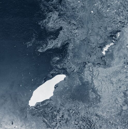
The colossus iceberg that split from Antarctica’s Larsen C ice shelf on 12 July 2017 is now in the open waters of the South Atlantic near the South Orkney Islands, about 1050 km from its birthplace. Having lost two chunks of ice, this record berg is a little less huge than it once was – and now that it is in rougher waters, it may break up further.
Přihlaste se na uživatelskou konferenci Esri – ještě to stihnete
10.7.2020 10:55 ARCDATAUživatelská konference Esri je jedinečnou příležitostí, jak se dozvědět, co se ve světě GIS Esri v uplynulém roce stalo, co se plánuje pro rok následující, jaké jsou nejnovější technologie a k čemu je můžete využít. Navštívit můžete také desítky technologických workshopů, které vás naučí efektivnější postupy v aplikacích, se kterými již pracujete, nebo vám představí aplikace nové.
Letošní konference se koná virtuálně. Účastnit se jí tedy může prakticky každý, stačí se pouze na stránkách konference zaregistrovat svým uživatelským účtem Esri. Součástí konference jsou jak přímé přenosy hlavních bloků konference, tak i záznamy přednášek a workshopů, interaktivní přehlídky aplikací a místa pro on-line setkávání uživatelů.
Čím ještě je virtuální konference výjimečná? To vám prozradíme v následujícím videu.
Bay of Naples, Italy
10.7.2020 10:00 ESA Observing the Earth Image:
The Copernicus Sentinel-1 mission takes us over the busy maritime traffic in the Bay of Naples, in southern Italy.
Image:
The Copernicus Sentinel-1 mission takes us over the busy maritime traffic in the Bay of Naples, in southern Italy.
Earth from Space: Bay of Naples
10.7.2020 10:00 ESA Observing the Earth Video:
00:03:01
Video:
00:03:01
In this week's edition of the Earth from Space programme, the Copernicus Sentinel-1 mission takes us over the busy maritime traffic in the Bay of Naples, in southern Italy.
See also Bay of Naples, Italy to download the image.
Aktualizace údajů
10.7.2020 9:15 Ústecký kraj V Geoportálu ÚAP Ústeckého kraje byla provedena aktualizace údajů pro poskytovatele Agentura ochrany přírody a krajiny České republiky – jev 27a, 32, ČEPRO, a.s. – jev 68, 70, 73, 76, 77a, 94a, ČEZ Teplárenská, a.s. – jev 79, 80, Národní agentura pro komunikační a informační technologie, s. p. – jev 82a a Ministerstvo vnitra – jev 82a, 110a, 112aHistorická ortofotomapa na Národním geoportálu INSPIRE
10.7.2020 9:09 CENIA - národní geoportál INSPIRE Vážení uživatelé, dovolujeme si Vás upozornit, že k 30.6.2020 byl ukončen přístup k aplikaci https://kontaminace.cenia.cz, a to z důvodu zastarání technického řešení a ukončení podpory některých softwarových komponent (Adobe Flash). Vrstva historického ortofota ČR z 50.let 20.st. je nadále dostupná z Národního geoportálu INSPIRE. Na tomto odkazu. Pro efektivní práci s mapovým oknem Vám...EuroGeographics highlights role of high value, authoritative, geospatial information in European Strategy for Data
10.7.2020 9:00 GISCafe.com Webcasts-Webinars High value, authoritative, geospatial data from official national sources has a significant role to play in the European Strategy for …UP42 Adds exactEarth Ship Tracking Data to Geospatial Marketplace
10.7.2020 9:00 GISCafe.com Webcasts-Webinars BERLIN, Germany, 7 July 2020 – UP42 today announced that global ship tracking data from exactEarth Ltd. is now offered on the UP42 developer …INSPIRE téma Rozšířené Parcely (CPX)
10.7.2020 2:00 Cenia - Katalog metadat ČR - INSPIRE Rozšíření má za cíl poskytovat katastrální mapu s obsahem podle vyhlášky ve vektorové podobě ve struktuře plně v souladu se strukturou danou směrnicí INSPIRE. Data rozšiřují směrnici INSPIRE pro téma katastrální parcely (CP) o věcná břemena, geodetické body, další prvky mapy, původní obloukovou geometrii a o parcely určené definičním bodem (ty pouze v oblastech s analogovou mapou). Vychází z katastrální mapy, která je závazným státním mapovým dílem velkého měřítka, obsahuje body polohového bodového pole, polohopis a popis a může mít formu digitální mapy, analogové mapy nebo digitalizované mapy. Publikovaná data obsahují katastrální území pro celou Českou Republiku, parcely a jejich hranice, věcná břemena, další prvky mapy a původní obloukovou geometrii z území, kde je digitální mapa (k 06. 07. 2020 je to 96,83% území České republiky, t.j. 76 363,06km2) a ve zbytku území katastrální parcely určené pouze definičním bodem (tedy bez hranic a polygonu). Katastrální parcely a hranice obsahují oproti datové sadě INSPIRE některé atributy navíc. Jedná se o typ hranice, způsob využití území, druh pozemku, vazbu na budovu a o mapové značky. Více katastrální zákon 344/1992 SB., katastrální vyhláška č.26/2007 Sb. v platném znění a INSPIRE Data Specification on Cadastral Parcels v 3.0.1. Data ve formátu GML 3.2.1 jsou validní proti schématu XML pro Rozšířené Parcely (CPX) ve verzi 4.0.Katastrální mapa ve formátech DGN a DXF poskytovaná v e-shopu
10.7.2020 2:00 Cenia - Katalog metadat ČR - INSPIRE Katastrální mapa je závazným státním mapovým dílem velkého měřítka, obsahuje body polohového bodového pole, polohopis a popis. Katastrální mapa ve vektorové podobě je poskytována zdarma ve formátu DGN a DXF a obsahuje prvky Digitální katastrální mapy (DKM) a Katastrální mapy digitalizované (KMD), tedy bodová pole, budovy, další prvky mapy, hranice parcel, katastrální hranice, parcely katastru nemovitostí, prvky orientační mapy a hranice věcného břemene. Z důvodu použití formátu DGN produkt neobsahuje značky na liniích a oblouky jsou nahrazeny lomenými čárami. Katastrální mapa ve vektorové podobě k 06. 07. 2020 pokrývá 96,83% území České republiky, t.j. 76 363,06km2. Více katastrální vyhláška č.357/2013 Sb. v platném znění.INSPIRE téma Adresy (AD)
10.7.2020 2:00 Cenia - Katalog metadat ČR - INSPIRE Data odpovídají směrnici INSPIRE pro téma adresy (AD). Vychází především z projektu RÚIAN (Registr územní identifikace, adres a nemovitostí), který je součástí základních registrů České Republiky a obsahuje informace o územní identifikaci, adresách a nemovitostech. Data publikovaná v rámci INSPIRE obsahují pouze adresní místa a jejich komponenty, kterými jsou stát, obec, část obce, městský obvod v Praze (MOP), městký obvod/městská část (MO/MČ), ulice a pošta a to na území celé České Republiky. Obsahují rozvněž geometrii, která určuje definiční bod adresního místa. V datové sadě nění uvedeno 1,14%, t.j. 33383 adresních míst (k 06. 07. 2020), protože neobsahují definiční bod, podle kterého by je bylo možné prostorově určit. Více v zákoně č. 111/2009 Sb., o základních registrech a ve vyhlášce č. 359/2011 Sb., o základním registru územní identifikace, adres a nemovitostí v platných zněních a INSPIRE Data Specification on Addresses v 3.0.1 z 26.4.2010. Data ve formátu GML 3.2.1 jsou validní proti schématu XML pro INSPIRE téma Adresy ve verzi 4.0 a proti schématu pro prostorová data ELF ve verzi 1.0.INSPIRE téma Budovy (BU)
10.7.2020 2:00 Cenia - Katalog metadat ČR - INSPIRE Data odpovídají směrnici INSPIRE pro téma budovy (BU). Data pochází částečně z projektu RÚIAN (Registr územní identifikace, adres a nemovitostí), který je součástí základních registrů České Republiky a obsahuje informace o územní identifikaci, adresách a nemovitostech, a částečně z ISKN (Informační systém katastru nemovistostí). Zdrojem informací o budovách v ISKN je objekt Stavba, v RÚIAN je to Stavební objekt. Většina Staveb je zároveň Stavebními objekty, ale jsou případy, kdy tomu tak není. Kromě Budov datová sada obsahuje i části budov, které jsou pro potřeby INSPIRE vyjádřeny vchody z RÚIAN. Vchody obsahují informace o počtu podlaží, technickoekonomických atributech apod. Datová sada pokrývá celé území české republiky. V datové sadě není uvedeno 1,14%, t.j. 48351 budov (k 06. 07. 2020), protože neobsahují definiční bod ani polygon. Více v zákoně č. 111/2009 Sb., o základních registrech, ve vyhlášce č. 359/2011 Sb., o základním registru územní identifikace, adres a nemovitostí v platných zněních, v zákoně 256/2013 Sb., o katastru nemovitostí, v katastrální vyhlášce č. 357/2013 Sb. v platném znění a INSPIRE Data Specification on Buildings v 3.0 z 13.12.2013. Data ve formátu GML 3.2.1 jsou validní proti schématu XML pro INSPIRE téma Budovy ve verzi 4.0 a proti schématu pro prostorová data ELF ve verzi 1.0.INSPIRE téma Parcely (CP)
10.7.2020 2:00 Cenia - Katalog metadat ČR - INSPIRE Data odpovídají směrnici INSPIRE pro téma katastrální parcely (CP). Vychází z katastrální mapy, která je závazným státním mapovým dílem velkého měřítka, obsahuje body polohového bodového pole, polohopis a popis a může mít formu digitální mapy, analogové mapy nebo digitalizované mapy. Data publikovaná v rámci INSPIRE obsahují pouze katastrální území (pro celou Českou Republiku) a parcely a jejich hranice z území, kde je digitální mapa (k 06. 07. 2020 je to 96,83% území České republiky, t.j. 76 363,06km2). Více katastrální zákon 344/1992 SB., katastrální vyhláška č.26/2007 Sb. v platném znění a INSPIRE Data Specification on Cadastral Parcels v 3.0.1. Data ve formátu GML 3.2.1 jsou validní proti schématu XML pro INSPIRE téma Parcely ve verzi 4.0 a proti schématu pro prostorová data ELF ve verzi 1.0.APGEO - Rozhovor s předsedou APG na webu ECHO24
10.7.2020 2:00 Asociace podnikatelů v geomatice Na webu Echo24 si můžete přečíst rozhovor s Ing. Martinem HrdličkouTraditional PC Shipments Continue to Grow Amid Global Economic Slowdown, According to IDC
10.7.2020 1:24 GISCafe.com Webcasts-Webinars FRAMINGHAM, Mass. — (BUSINESS WIRE) — July 9, 2020 —The second quarter of 2020 (2Q20) ended well for the Traditional PC market, …
Komplexní řešení intenzivní zemědělské krajiny po pozemkové úpravě
10.7.2020 0:00 Státní pozemkový úřad Komplexní pozemkové úpravy řeší ve většině případů dané katastrální území uceleně a ve veřejném zájmu prostorově a funkčně uspořádávají pozemky, scelují se nebo dělí, zabezpečuje se jejich přístupnost, vyrovnání hranic a vytvoření podmínek pro racionální hospodaření. Současně se zvyšuje prostupnost zemědělské krajiny a zajišťují se podmínky pro zlepšení kvality života ve venkovských oblastech. Realizovaná společná zařízení po pozemkových úpravách zlepšují kvalitu životního prostředí, zvyšují ekologickou stabilitu krajiny a ochranu zemědělského půdního fondu. Ve zpracovaném území dochází k úpravám vodního režimu, zejména v oblasti snižování nepříznivých účinků přívalových dešťů, povodní a sucha, k řešení odtokových poměrů a vytváření retenčních prostorů v krajině. Pro příklad jsem vybral realizovaná společná zařízení na části území obce Choťovice v okrese Kolín, dříve okres Nymburk.Hexagon to Deliver Cloud-Based Public Safety Technologies to Oregon Health & Science University via Fully Remote Deployment
9.7.2020 22:29 Hexagon Safety & InfrastructureHexagon to Deliver Cloud-Based Public Safety Technologies to Oregon Health & Science University via Fully Remote Deployment
9.7.2020 22:29 Hexagon Safety & InfrastructureThe 2020 Recipient of the Arthur C. Lundahl-Thomas C. Finnie Lifetime Achievement Award
9.7.2020 17:17 GISCafe.com Webcasts-Webinars USGIF’s virtual GEOConnect Series Main Stage EventThe Honorable Sue Gordon was awarded the Lifetime Achievement Award
Herndon, VA ( 9 …
Bentley Systems’ Acceleration Fund Announces the Launch of Virtuosity, a Bentley Company
9.7.2020 16:34 GISCafe.com Webcasts-Webinars New Global Reseller’s Virtuoso Subscriptions Uniquely Combine Bentley’s Infrastructure Applications with Expert ServicesEXTON, Pa. — …
AgEagle Aerial Systems Selects Wichita, Kansas to Locate and Expand Manufacturing Facilities
9.7.2020 16:34 GISCafe.com Webcasts-Webinars NEODESHA, Kan., July 09, 2020 (GLOBE NEWSWIRE) -- AgEagle Aerial Systems Inc. (NYSE American: UAVS), an industry leading provider of UAVs and …National Geospatial Information Center Boosts Luokung's all Aspects of Development in Application for Geospatial Information industrialization
9.7.2020 16:34 GISCafe.com Webcasts-Webinars BEIJING, July 9, 2020 — (PRNewswire) — Luokung Technology Corp. (NASDAQ: LKCO) ("Luokung" or the "Company"), one of the global leading …Guidance Issued for States to Strengthen Address Data Programs
9.7.2020 16:28 GISCafe.com Webcasts-Webinars Complete & Accurate Data Necessary for Emergency Response, Other Government Services
July 8, 2020, New Orleans, LA - A report issued …
ekonom - asistent
9.7.2020 14:02 ČÚZK - volná místa Katastrální úřad pro Středočeský kraj - Katastrální pracoviště Rakovník vypisuje výběrové řízení na místo ekonom - asistentekonom - asistent
9.7.2020 14:02 ČÚZK /Urady/Katastralni-urady/Katastralni-urady/Katastralni-urad-pro-Stredocesky-kraj/Volna-mista/ekonom-asistentekonom - asistent
9.7.2020 14:02 ČÚZK - předpisy a opatření Katastrální úřad pro Středočeský kraj - Katastrální pracoviště Rakovníkvypisuje výběrové řízení na místo ekonom - asistent
ekonom - asistent
Satellites track unusual Saharan dust plume
9.7.2020 13:05 ESA Observing the Earth
Every summer, the wind carries large amounts of desert dust particles from the hot and dry Sahara Desert in northern Africa across the Atlantic Ocean. Data from the Copernicus Sentinel satellites and ESA’s Aeolus satellite show the extent of this year’s summer dust plume, dubbed ‘Godzilla,’ on its journey across the Atlantic.
Novinky na ArcGIS Online – červenec 2020
9.7.2020 12:42 ARCDATANa začátku července proběhla aktualizace prostředí ArcGIS Online. S některými nejvýznamnějšími změnami vás seznámíme v tomto článku.
Nový editor domovské stránky organizace
Domovská stránka organizace získala nový vzhled a také editor, ve kterém si stránku můžeme přizpůsobit. Záhlaví je určeno pro grafiku, název organizace a její logo. Tělo stránky pojme až pět bloků, které mohou obsahovat text či galerii položek z vybrané skupiny. Stránka je optimalizována pro použití na PC, tabletech i mobilních telefonech.
Novou domovskou stránku si můžeme nejprve připravit, vyzkoušet, a až bude vše nachystáno, změnu veřejně zpublikovat.

ArcGIS Notebooks
ArcGIS Notebooks je technologie pro vytváření, spouštění a sdílení programů a skriptů v jazyku Python. Notebook představuje interaktivní webové uživatelské rozhraní, ve kterém lze psát kód, dokumentovat jej a současně jej spouštět. Vše se odehrává ve webovém prohlížeči. V jeho prostředí se jednotlivé příkazy ukládají, můžeme se k nim vracet, upravovat je a spouštět v libovolném pořadí. Na ArcGIS Online jsme s Notebooky mohli zatím pracovat v beta verzi, nyní se staly oficiální součásti ArcGIS Online.
Každý vytvořený Notebook je uložen v portálu jako nová položka. Je tak možné jej sdílet s vybranou skupinou uživatelů nebo jej kdykoliv otevřít, spustit, aktualizovat či stáhnout.
Při vytváření nového Notebooku uživatel vybírá, v rámci jakého prostředí bude Notebook vytvořen:
- Standard obsahuje knihovny ArcGIS API for Python, vybrané open source knihovny a má omezený výpočetní výkon a dostupnou pamět.
- Advanced obsahuje knihovny z prostředí Standard, knihovny ArcPy a disponuje vyšším výpočetním výkonem.
- Advanced with GPU má navíc možnost použít GPU pro výpočetně náročné operace.
Použití prostředí Standard je bezplatné, použití Advanced a Advanced s GPUspotřebovává kredity v závislosti na využití.

Expresní nastavení mapových aplikací
Snadnou cestou, jak vytvořit webovou aplikaci, je v Prohlížeči map na ArcGIS Online použít tlačítko Sdílet a následně Vytvořit webovou aplikaci. Pak je možné zvolit některou ze šablon. Nově některé šablony (např. Nearby, Minimalist, Zone Lookup a Attachment Viewer) obsahují i funkci Expresní nastavení, díky které lze to nejdůležitější nastavit jen pomocí několika kliknutí.

Vylepšená správa
Správci organizace mohou vytvářet nové podrobné reporty. Na stránce Organizace – Stav – Reporty si mohou vytvořit zprávu o členech či o položkách v organizaci. Výsledkem je CSV soubor s výpisem dat.
Je zlepšena podpora přihlašování pomocí OpenID a vedle přihlášení účtem Facebook, Google a GitHub je možné se přihlásit i pomocí účtu Apple.
Snáze se dají hromadně přesouvat položky jednoho uživatele druhému, což je praktické zejména když potřebujeme odstranit uživatelský účet z organizace, ale jeho obsah musíme rozdělit mezi různé uživatele.
A pokud je potřeba uživatelům odstranit možnost stahování softwaru ze stránky Moje nastavení – Licence (například je zde možné stahovat instalační soubor k ArcGIS Pro), správci organizace na to získali nový přepínač.
Novinky v Prohlížeči map
K dispozici jsou dvě nové možnosti vykreslování rastrových služeb. Tyto možnosti nalezneme v Nabídce vrstvy – Zobrazení snímku – Vykreslovač. V této nabídce jsou k dispozici různé způsoby vykreslení (pro data obsahující nadmořskou výšku to jsou například vykreslovače „svažitost“, „orientace“, „stínování“ apod.), které jsou definované při publikaci dotyčné služby. Uživatel nyní může v nabídce Zlepšení obrazu: Typ symboliky vybrat vlastní nastavení stínovaného reliéfu: určit pozici Slunce, převýšení i použitou barevnou hypsometrickou stupnici.

Je také možné používat typ symboliky Mapa barev, který aplikuje předdefinované barvy jednotlivým hodnotám rastru. Vhodný je tedy pro klasifikované rastry.

Prohlížeč map Beta
Betaverze nového prohlížeče map se v nejbližších dnech dočká také nové funkcionality. Vrstvy v mapě bude možné slučovat do skupin, shluky prvků budou moci mít vlastní popisky (dosud byly k dispozici jen vyskakovací okna) a přijde lepší podpora vektorových symbolů.
Podrobný přehled novinek červencové aktualizace ArcGIS Online naleznete ve článku What's new in ArcGIS Online (June 2020), případně v dokumentaci What's new.
Esri Recognizes Cartegraph for Expertise in Indoor Mapping and Infrastructure Management
9.7.2020 9:00 GISCafe.com Webcasts-Webinars Cartegraph, a leading provider of building and infrastructure management software, is proud to be named an ArcGIS Indoors Specialty Partner …Přírodní parky Jč. kraje
9.7.2020 7:30 Jihočeský kraj V sekci Životní prostředí byla zpřístupněna ke stažení data vymezení Přírodních parků Jihočeského kraje pod licencí CC0 ve vektorových formátech SHP, GPKG a KML.Přírodní parky Jč. kraje
9.7.2020 7:30 Jihočeský kraj V sekci Životní prostředí byla zpřístupněna ke stažení data vymezení Přírodních parků Jihočeského kraje pod licencí CC0 ve vektorových formátech SHP, GPKG a KML.Bentley Systems’ Acceleration Fund Announces the Launch of Virtuosity, a Bentley Company
9.7.2020 2:00 Bentley SystemsNew Global Reseller’s Virtuoso Subscriptions Uniquely Combine Bentley’s Infrastructure Applications with Expert Services
EXTON, Pa. – July 9, 2020 – Bentley Systems, Incorporated, a leading global provider of comprehensive software and digital twins services for advancing the design, construction, and operations of infrastructure, today announced that its Acceleration Fund has invested in launching Virtuosity, a Bentley company. Virtuosity exclusively offers Virtuoso Subscriptions that bundle — with a Bentley infrastructure modeling, simulation, or construction application — the virtually delivered services of Virtuosity’s experts to accelerate and advance the success of an infrastructure practitioner.
Virtuoso Subscriptions are now available, at virtuosity.com, for Bentley applications including MicroStation, OpenBridge, OpenBuildings, OpenFlows, OpenRail, OpenRoads, OpenSite, OpenTower, OpenWindPower, AutoPIPE, ContextCapture, LEGION, MOSES, PLAXIS, RAM, SACS, SoilVision, STAAD, and SYNCHRO, and Bentley’s iTwin Design Review cloud service. Virtuosity’s expert services, accessible through Virtuoso Subscription “keys,” include a range of training and one-to-one mentoring activities, and on-demand learning and content, increasingly integrated during actual application usage.
Allan Murphy, Virtuosity CEO, said, “The world’s infrastructure professionals have all gained a new appreciation for what can be achieved through online collaboration. We think this is the perfect time to inaugurate our commercial innovation: a virtuoso subscription that enhances the functionality of a software application through intrinsic assistance from subject matter experts. We’re marshalling and virtualizing our domain expertise to help every infrastructure practitioner perform with the confidence of a virtuoso!”
Werner Felber, Managing Partner, Boley Geotechnick GmbH, Beratende Ingenieure, said, “With Virtuoso Subscriptions, professionals across our international teams can support projects more effectively. Virtuosity’s experts will help keep us current in going digital by constantly leveraging what’s new in Bentley’s applications to ensure our competitiveness in the market and the best results for our customers.”
Image:Virtuosity logo
Image: Allan Murphy headshot
YouTube video: The Value of a Virtuoso Subscription
##
About Virtuosity, a Bentley Company
Virtuosity is the exclusive global provider of Virtuoso Subscriptions for Bentley Systems’ infrastructure modeling, simulation, and construction applications. Every Virtuoso Subscription—procured through the ecommerce site virtuosity.com—uniquely bundles, with a Bentley software application, virtually delivered services of Virtuosity’s experts to accelerate and advance the success of an infrastructure practitioner.
About Bentley Systems’ Acceleration Fund
Bentley Systems’ Acceleration Fund was founded in 2020 to invest in new and incremental participants in open ecosystems to advance infrastructure digital twins. The Bentley Systems Acceleration Fund is chartered to accelerate the creation and curation of digital twins, and to foster technologies and innovations so enabled, by nurturing new ventures, making minority investments, and acquiring and expanding digital integrators. Investments to date include Digital Water Works, Digital Construction Works, Virtuosity, and The Cohesive Companies. Chief Acceleration Officer Santanu Das welcomes queries from potential ecosystem participants at www.bentleyaccelerationfund.com.
About Bentley Systems
Bentley Systems is a leading global provider of software solutions to engineers, architects, geospatial professionals, constructors, and owner-operators for the design, construction, and operations of infrastructure. Bentley’s MicroStation-based engineering and BIM applications, and its digital twin cloud services, advance the project delivery (ProjectWise) and the asset performance (AssetWise) of transportation and other public works, utilities, industrial and resources plants, and commercial and institutional facilities.
Bentley Systems employs more than 3,500 colleagues and generates annual revenues of more than $700 million in 172 countries. From inception in 1984, the company has remained majority-owned by its five founding Bentley brothers. www.bentley.com
Bentley, the Bentley logo, Bentley Acceleration Fund, AssetWise, AutoPIPE, ContextCapture, iTwin, LEGION, MicroStation, MOSES, OpenBridge, OpenBuildings, OpenFlows, OpenRail, OpenRoads, OpenSite, OpenTower, OpenWindPower, PLAXIS, ProjectWise, RAM, SACS, SoilVision, STAAD, SYNCHRO, Digital Water Works, The Cohesive Companies, Virtuosity, and Virtuoso Subscription are either registered or unregistered trademarks or service marks of Bentley Systems, Incorporated or one of its direct or indirect wholly owned subsidiaries. All other brands and product names are trademarks of their respective owners.Geofyzikální sítě CzechGeo
9.7.2020 2:00 Cenia - Katalog metadat ČR - INSPIRE Databáze obsahuje informace o dvou desítkách geofyzikálních sítí, které provozují geovědní instituce ČR konsorcia CzechGeo (ústavy AV ČR, fakulty univerzit atd.) na území ČR i v zahraničíj. Jsou zde zachyceny observatoře, stálé stanice a měřící body kampaní (seismické, GPS, magnetické, gravimetrické a geodynamické), zapojené do lokálních i globálních datových sítí.Bentley Systems’ Acceleration Fund Announces the Launch of Virtuosity, a Bentley Company
9.7.2020 2:00 Bentley SystemsNew Global Reseller’s Virtuoso Subscriptions Uniquely Combine Bentley’s Infrastructure Applications with Expert Services
EXTON, Pa. – July 9, 2020 – Bentley Systems, Incorporated, a leading global provider of comprehensive software and digital twins services for advancing the design, construction, and operations of infrastructure, today announced that its Acceleration Fund has invested in launching Virtuosity, a Bentley company. Virtuosity exclusively offers Virtuoso Subscriptions that bundle — with a Bentley infrastructure modeling, simulation, or construction application — the virtually delivered services of Virtuosity’s experts to accelerate and advance the success of an infrastructure practitioner.
Virtuoso Subscriptions are now available, at virtuosity.com, for Bentley applications including MicroStation, OpenBridge, OpenBuildings, OpenFlows, OpenRail, OpenRoads, OpenSite, OpenTower, OpenWindPower, AutoPIPE, ContextCapture, LEGION, MOSES, PLAXIS, RAM, SACS, SoilVision, STAAD and SYNCHRO, and Bentley’siTwin Design Reviewcloud service. Virtuosity’s expert services, accessible through Virtuoso Subscription “keys,” include a range of training and one-to-one mentoring activities, and on-demand learning and content, increasingly integrated during actual application usage.
Allan Murphy, Virtuosity CEO, said, “The world’s infrastructure professionals have all gained a new appreciation for what can be achieved through online collaboration. We think this is the perfect time to inaugurate our commercial innovation: a virtuoso subscription that enhances the functionality of a software application through intrinsic assistance from subject matter experts. We’re marshalling and virtualizing our domain expertise to help every infrastructure practitioner perform with the confidence of a virtuoso!”
Werner Felber, Managing Partner, Boley Geotechnick GmbH, Beratende Ingenieure, said, “With Virtuoso Subscriptions, professionals across our international teams can support projects more effectively. Virtuosity’s experts will help keep us current in going digital by constantly leveraging what’s new in Bentley’s applications to ensure our competitiveness in the market and the best results for our customers.”
Image: Virtuosity logo
Image: Allan Murphy headshot
YouTube video: The Value of a Virtuoso Subscription
##
About Virtuosity, a Bentley Company
Virtuosity is the exclusive global provider of Virtuoso Subscriptions for Bentley Systems’ infrastructure modeling, simulation, and construction applications. Every Virtuoso Subscription—procured through the ecommerce site virtuosity.com—uniquely bundles, with a Bentley software application, virtually delivered services of Virtuosity’s experts to accelerate and advance the success of an infrastructure practitioner.
About Bentley Systems’ Acceleration Fund
Bentley Systems’ Acceleration Fund was founded in 2020 to invest in new and incremental participants in open ecosystems to advance infrastructure digital twins. The Bentley Systems Acceleration Fund is chartered to accelerate the creation and curation of digital twins, and to foster technologies and innovations so enabled, by nurturing new ventures, making minority investments, and acquiring and expanding digital integrators. Investments to date include Digital Water Works, Digital Construction Works, Virtuosity, and The Cohesive Companies. Chief Acceleration Officer Santanu Das welcomes queries from potential ecosystem participants at www.bentleyaccelerationfund.com.
About Bentley Systems
Bentley Systems is a leading global provider of software solutions to engineers, architects, geospatial professionals, constructors, and owner-operators for the design, construction, and operations of infrastructure. Bentley’s MicroStation-based engineering and BIM applications, and its digital twin cloud services, advance the project delivery (ProjectWise) and the asset performance (AssetWise) of transportation and other public works, utilities, industrial and resources plants, and commercial and institutional facilities.
Bentley Systems employs more than 3,500 colleagues and generates annual revenues of more than $700 million in 172 countries. From inception in 1984, the company has remained majority-owned by its five founding Bentley brothers. www.bentley.com
Bentley, the Bentley logo, Bentley Acceleration Fund, AssetWise, AutoPIPE, ContextCapture, iTwin, LEGION, MicroStation, MOSES, OpenBridge, OpenBuildings, OpenFlows, OpenRail, OpenRoads, OpenSite, OpenTower, OpenWindPower, PLAXIS, ProjectWise, RAM, SACS, SoilVision, STAAD, SYNCHRO, Digital Water Works, The Cohesive Companies, Virtuosity, and Virtuoso Subscription are either registered or unregistered trademarks or service marks of Bentley Systems, Incorporated or one of its direct or indirect wholly owned subsidiaries. All other brands and product names are trademarks of their respective owners.
Bentley Systems’ Acceleration Fund Announces the Launch of Virtuosity, a Bentley Company
9.7.2020 2:00 Bentley SystemsNew Global Reseller’s Virtuoso Subscriptions Uniquely Combine Bentley’s Infrastructure Applications with Expert Services
EXTON, Pa. – July 9, 2020 – Bentley Systems, Incorporated, a leading global provider of comprehensive software and digital twins services for advancing the design, construction, and operations of infrastructure, today announced that its Acceleration Fund has invested in launching Virtuosity, a Bentley company. Virtuosity exclusively offers Virtuoso Subscriptions that bundle — with a Bentley infrastructure modeling, simulation, or construction application — the virtually delivered services of Virtuosity’s experts to accelerate and advance the success of an infrastructure practitioner.
Virtuoso Subscriptions are now available, at virtuosity.com, for Bentley applications including MicroStation, OpenBridge, OpenBuildings, OpenFlows, OpenRail, OpenRoads, OpenSite, OpenTower, OpenWindPower, AutoPIPE, ContextCapture, LEGION, MOSES, PLAXIS, RAM, SACS, SoilVision, STAAD and SYNCHRO, and Bentley’s iTwin Design Review cloud service. Virtuosity’s expert services, accessible through Virtuoso Subscription “keys,” include a range of training and one-to-one mentoring activities, and on-demand learning and content, increasingly integrated during actual application usage.
Allan Murphy, Virtuosity CEO, said, “The world’s infrastructure professionals have all gained a new appreciation for what can be achieved through online collaboration. We think this is the perfect time to inaugurate our commercial innovation: a virtuoso subscription that enhances the functionality of a software application through intrinsic assistance from subject matter experts. We’re marshalling and virtualizing our domain expertise to help every infrastructure practitioner perform with the confidence of a virtuoso!”
Werner Felber, Managing Partner, Boley Geotechnick GmbH, Beratende Ingenieure, said, “With Virtuoso Subscriptions, professionals across our international teams can support projects more effectively. Virtuosity’s experts will help keep us current in going digital by constantly leveraging what’s new in Bentley’s applications to ensure our competitiveness in the market and the best results for our customers.”
Image: Virtuosity logo
Image: Allan Murphy headshot
YouTube video: The Value of a Virtuoso Subscription
##
About Virtuosity, a Bentley Company
Virtuosity is the exclusive global provider of Virtuoso Subscriptions for Bentley Systems’ infrastructure modeling, simulation, and construction applications. Every Virtuoso Subscription—procured through the ecommerce site virtuosity.com—uniquely bundles, with a Bentley software application, virtually delivered services of Virtuosity’s experts to accelerate and advance the success of an infrastructure practitioner.
About Bentley Systems’ Acceleration Fund
Bentley Systems’ Acceleration Fund was founded in 2020 to invest in new and incremental participants in open ecosystems to advance infrastructure digital twins. The Bentley Systems Acceleration Fund is chartered to accelerate the creation and curation of digital twins, and to foster technologies and innovations so enabled, by nurturing new ventures, making minority investments, and acquiring and expanding digital integrators. Investments to date include Digital Water Works, Digital Construction Works, Virtuosity, and The Cohesive Companies. Chief Acceleration Officer Santanu Das welcomes queries from potential ecosystem participants at www.bentleyaccelerationfund.com.
About Bentley Systems
Bentley Systems is a leading global provider of software solutions to engineers, architects, geospatial professionals, constructors, and owner-operators for the design, construction, and operations of infrastructure. Bentley’s MicroStation-based engineering and BIM applications, and its digital twin cloud services, advance the project delivery (ProjectWise) and the asset performance (AssetWise) of transportation and other public works, utilities, industrial and resources plants, and commercial and institutional facilities.
Bentley Systems employs more than 3,500 colleagues and generates annual revenues of more than $700 million in 172 countries. From inception in 1984, the company has remained majority-owned by its five founding Bentley brothers. www.bentley.com
Bentley, the Bentley logo, Bentley Acceleration Fund, AssetWise, AutoPIPE, ContextCapture, iTwin, LEGION, MicroStation, MOSES, OpenBridge, OpenBuildings, OpenFlows, OpenRail, OpenRoads, OpenSite, OpenTower, OpenWindPower, PLAXIS, ProjectWise, RAM, SACS, SoilVision, STAAD, SYNCHRO, Digital Water Works, The Cohesive Companies, Virtuosity, and Virtuoso Subscription are either registered or unregistered trademarks or service marks of Bentley Systems, Incorporated or one of its direct or indirect wholly owned subsidiaries. All other brands and product names are trademarks of their respective owners.
ProStar Joins Trimble's GIS Business Partner Program to Define the Next Generation of Utility Mapping
9.7.2020 1:33 GISCafe.com Webcasts-Webinars Trimble GNSS Integrates with PointMan Field Applications to Identify, Capture and Record the Precise Geospatial Location of UtilitiesSUNNYVALE, …
Developers are invited to the OGC Interoperable Simulation and Gaming Sprint
8.7.2020 18:27 GISCafe.com Webcasts-Webinars This OGC Sprint will test a draft API that provides a simple method to retrieve 3D tiled resources in a manner independent of the underlying …
Airbus Partnership Supports 4 Earth Intelligence Vision for Satellite Services
8.7.2020 17:32 GISCafe.com Webcasts-Webinars Bristol, UK, 08 July 2020 - Earth observation company 4 Earth Intelligence (4EI) is partnering with Airbus Defence and Space to release the power of …Revolutionary Full Asset Planning Solution Provided by Utilis and Innovyze
8.7.2020 16:22 GISCafe.com Webcasts-Webinars Partnership will Jointly Provide Tools for UtilitiesSAN DIEGO, July 8, 2020 — (PRNewswire) —
SAN DIEGO, July 8, 2020 …
ViaMichelin Awards TomTom New Global Deal
8.7.2020 16:22 GISCafe.com Webcasts-Webinars AMSTERDAM, July 08, 2020 (GLOBE NEWSWIRE) -- TomTom (TOM2), the location technology specialist, today announced an extension of its global deal to …Esri President Jack Dangermond Addresses UN High Level Political Forum
8.7.2020 16:22 GISCafe.com Webcasts-Webinars GIS Software Leader Speaks on COVID-19 and Sustainable Development GoalsREDLANDS, Calif. — (BUSINESS WIRE) — July 8, 2020 —
Esri, …
Trimble and Cityworks Introduces Real-Time Asset Management Solution for Water and Wastewater Utilities
8.7.2020 16:22 GISCafe.com Webcasts-Webinars Trimble Unity Remote Monitoring and Trimble's Telog IoT Recorders Integrate with Cityworks Asset Management Software to Create an End-to-End Solution …SensorUp Secures Series A Financing led by Evok Innovations
8.7.2020 16:22 GISCafe.com Webcasts-Webinars CALGARY, Alberta, July 08, 2020 (GLOBE NEWSWIRE) -- SensorUp, a Calgary-based SaaS provider in the movement intelligence space, today announced the …Descartes Labs wins Phase II SBIR through AFWERX to boost U.S. Air Force innovation
8.7.2020 16:22 GISCafe.com Webcasts-Webinars SANTA FE, N.M., July 08, 2020 (GLOBE NEWSWIRE) -- Descartes Labs, a New Mexico-based geospatial analytics company, today announced that it has been …Intermap Technologies Provides Business and Financial Update
8.7.2020 16:22 GISCafe.com Webcasts-Webinars DENVER, July 8, 2020 — (PRNewswire) — Intermap Technologies Corporation ("Intermap" or the "Company") today announced preliminary …FARO® Launches Freestyle 2 Portable 3D Scanner
8.7.2020 16:22 GISCafe.com Webcasts-Webinars LAKE MARY, Fla., July 8, 2020 — (PRNewswire) — FARO Technologies, Inc. (NASDAQ: FARO), the global leader for 3D …Přerušení dodávky elektrické energie
8.7.2020 12:39 ČÚZK /Urady/Katastralni-urady/Katastralni-urady/Katastralni-urad-pro-Moravskoslezsky-kraj/Katastralni-pracoviste/KP-Ostrava/O-uradu/Aktuality/Preruseni-dodavky-elektricke-energiePřerušení dodávky elektrické energie
8.7.2020 12:39 ČÚZK - předpisy a opatření Katastrální úřad pro Moravskoslezský kraj - Katastrální pracoviště Ostrava zveřejnil novou aktualitu: Vážení klienti,z důvodu přerušení dodávky elektrické energie dodavatelem ČEZ Distribuce, a.s. bude dne 27. 7. 2020 od 8:00h do 14:00h pro veřejnost Katastrální pracoviště Ostrava uzavřeno.
Děkujeme za pochopení.
Mgr. Marcela Staniczková, ředitelka pracoviště
Přerušení dodávky elektrické energie
8.7.2020 12:39 ČÚZK - předpisy a opatření Katastrální úřad pro Moravskoslezský kraj - Katastrální pracoviště Ostrava zveřejnil novou aktualitu: Vážení klienti,z důvodu přerušení dodávky elektrické energie dodavatelem ČEZ Distribuce, a.s. bude dne 27. 7. 2020 od 8:00h do 11:30h pro veřejnost Katastrální pracoviště Ostrava uzavřeno.
Děkujeme za pochopení.
Mgr. Marcela Staniczková, ředitelka pracoviště
IoT positioning in the spotlight at GSA webinar
8.7.2020 9:53 European GNSS Agency
Over 100 participants came together online on 18 June to discuss power-efficient positioning for the Internet of Things at a webinar organised by the European GNSS Agency (GSA). At the webinar, which featured input from innovation projects and major chipset manufacturers in the IoT domain, the European GNSS Agency (GSA) presented its recent White Paper on the topic.
The GSA White Paper on Power-efficient positioning for the Internet of Things provides an overview of GNSS technologies that are relevant for low-power IoT applications, including those that require hybridisation with other connectivity solutions. Participants in the webinar were introduced to the main findings from the paper.
According to the White Paper, GNSS is a viable solution for outdoor tracking of IoT objects but the level of power consumption associated with positioning can be a block to increased GNSS uptake. In the White Paper, three main approaches are identified to reduce GNSS power consumption. Firstly, there is the use of assisted GNSS, which consists in using a communication network to supply the GNSS receiver with data that makes it possible to speed up the acquisition phase.
The second approach involves the transmission of pseudoranges, where the power consumption related to determining position is saved by transmitting the measurements to an external facility with no power restrictions. Finally, use of snapshot techniques means that the GNSS receiver is only activated for short periods to determine the position.
Big potential for GNSS
“We see big potential for the use of GNSS in the Internet of Things, but this potential is not yet being exploited. This is why we published our White Paper, explaining how to unblock it, and organised this webinar at which innovation projects explained their GNSS-based solutions providing real benefits to the IoT,” Fiammetta Diani, Head of Market Development at the GSA, said at the start of the webinar.
In addition to innovation projects, well-established manufacturers ST Microelectronics and u-blox also presented their GNSS-based positioning solutions providing reduced power consumption, making them ideal for the Internet of Things. Such an example includes STMicroelectronic’s Teseo LIV-3F, a tiny GNSS module for IoT that, despite its small size, provides the same robustness and reliability as bigger GNSS automotive solutions.
Also presenting at the webinar were EU-funded R&D projects that are working to optimise energy use of GNSS positioning for IoT applications. These include: “Accurate GNSS POsitioning for Low power and Low-cost Objects” (APOLLO), which aims at providing a Galileo-based geolocation solution for the IoT market by drastically reducing energy consumption.
Also presenting were GEONAV IoT, which is working to develop and deliver precise ubiquitous positioning and navigation applications and services; and Galileo of Things (GoT), which is targeting the delivery of a Galileo semiconductor-IP core that mates with NB-IoT IP for low-power consumption solutions.
Enthusiastic uptake
Global uptake of IoT applications has been rapid and enthusiastic and by 2022 it is estimated that around 18 billion out of 29 billion connected devices will be related to the IoT. With many interconnected devices in the IoT environment constantly on the move, there are applications that require or might at least benefit from knowing the precise location of a given device.
In light of the power-saving solutions highlighted in the GSA White Paper and discussed during the recent webinar, it is clear that GNSS industry is listening to the needs of the IoT community so that the most accurate positioning solution can play an increasingly important role without depleting the precious batteries of the devices.
This webinar is just one of the many online activities GSA has been organizing to support IoT and the use of GNSS to boost innovative solutions. “There is still plenty of room for GNSS based solutions in the IoT ecosystem, but a larger number of available options and the variety of applications will require more knowledge in order to choose the best solution for each specific application”, said Oreste Concepito from u-blox.
Media note: This feature can be republished without charge provided the European GNSS Agency (GSA) is acknowledged as the source at the top or the bottom of the story. You must request permission before you use any of the photographs on the site. If you republish, we would be grateful if you could link back to the GSA website (http://www.gsa.europa.eu).
IoT positioning in the spotlight at GSA webinar
8.7.2020 9:53 European GNSS AgencyOver 100 participants came together online on 18 June to discuss power-efficient positioning for the Internet of Things at a webinar organised by the European GNSS Agency (GSA). At the webinar, which featured input from innovation projects and major chipset manufacturers in the IoT domain, the European GNSS Agency (GSA) presented its recent White Paper on the topic.
The GSA White Paper on Power-efficient positioning for the Internet of Things provides an overview of GNSS technologies that are relevant for low-power IoT applications, including those that require hybridisation with other connectivity solutions. Participants in the webinar were introduced to the main findings from the paper.
According to the White Paper, GNSS is a viable solution for outdoor tracking of IoT objects but the level of power consumption associated with positioning can be a block to increased GNSS uptake. In the White Paper, three main approaches are identified to reduce GNSS power consumption. Firstly, there is the use of assisted GNSS, which consists in using a communication network to supply the GNSS receiver with data that makes it possible to speed up the acquisition phase.
The second approach involves the transmission of pseudoranges, where the power consumption related to determining position is saved by transmitting the measurements to an external facility with no power restrictions. Finally, use of snapshot techniques means that the GNSS receiver is only activated for short periods to determine the position.
Big potential for GNSS
“We see big potential for the use of GNSS in the Internet of Things, but this potential is not yet being exploited. This is why we published our White Paper, explaining how to unblock it, and organised this webinar at which innovation projects explained their GNSS-based solutions providing real benefits to the IoT,” Fiammetta Diani, Head of Market Development at the GSA, said at the start of the webinar.
In addition to innovation projects, well-established manufacturers ST Microelectronics and u-blox also presented their GNSS-based positioning solutions providing reduced power consumption, making them ideal for the Internet of Things. Such an example includes STMicroelectronic’s Teseo LIV-3F, a tiny GNSS module for IoT that, despite its small size, provides the same robustness and reliability as bigger GNSS automotive solutions.
Also presenting at the webinar were EU-funded R&D projects that are working to optimise energy use of GNSS positioning for IoT applications. These include: “Accurate GNSS POsitioning for Low power and Low-cost Objects” (APOLLO), which aims at providing a Galileo-based geolocation solution for the IoT market by drastically reducing energy consumption.
Also presenting were GEONAV IoT, which is working to develop and deliver precise ubiquitous positioning and navigation applications and services; and Galileo of Things (GoT), which is targeting the delivery of a Galileo semiconductor-IP core that mates with NB-IoT IP for low-power consumption solutions.
Enthusiastic uptake
Global uptake of IoT applications has been rapid and enthusiastic and by 2022 it is estimated that around 18 billion out of 29 billion connected devices will be related to the IoT. With many interconnected devices in the IoT environment constantly on the move, there are applications that require or might at least benefit from knowing the precise location of a given device.
In light of the power-saving solutions highlighted in the GSA White Paper and discussed during the recent webinar, it is clear that GNSS industry is listening to the needs of the IoT community so that the most accurate positioning solution can play an increasingly important role without depleting the precious batteries of the devices.
This webinar is just one of the many online activities GSA has been organizing to support IoT and the use of GNSS to boost innovative solutions. “There is still plenty of room for GNSS based solutions in the IoT ecosystem, but a larger number of available options and the variety of applications will require more knowledge in order to choose the best solution for each specific application”, said Oreste Concepito from u-blox.
Media note: This feature can be republished without charge provided the European GNSS Agency (GSA) is acknowledged as the source at the top or the bottom of the story. You must request permission before you use any of the photographs on the site. If you republish, we would be grateful if you could link back to the GSA website (http://www.gsa.europa.eu).
Aktualizace základního mapování biotopů
8.7.2020 2:00 Cenia - Katalog metadat ČR - INSPIRE Aktualizace vrstvy segmentů biotopů a relačních databází (biotopy, taxony) probíhá v pravidelných cyklech. Frekvence cyklů aktualizace je plánována jako 12letá. Aktualizace byla zahájena v roce 2007. Ve vrstvě a tabulkách jsou aktualizované a neaktualizované záznamy (pole ROK_AKT). Vrstva obsahuje hranice segmentů přírodních biotopů a biotopů silně ovlivněných nebo vytvořených člověkem z aktualizace základního mapování biotopů. Znalost rozšíření biotopů silně ovlivněných nebo vytvořených člověkem není plošná, vrstva poskytuje informace o rozšíření nepřírodních biotopů pouze na malé části území ČR.Data z mapování biotopů neposkytují vyčerpávající informaci o vegetaci, resp. biotopech daného území. Mapování je metodicky nastaveno na celostátní úrovni, a především efemérní biotopy tak může pominout. V lokálním měřítku proto představuje pouze zjednodušený podklad. Pro detailnější informaci je třeba vyhledat jiné datové zdroje. Základní mapování bylo provedeno v letech 2001–2005.Klasifikace biotopů viz CHYTRÝ, M.; KUČERA, T.; KOČÍ, M. (eds.) et al. (2010). Katalog biotopů České republiky. 2.upr. a rozš.vyd. Praha: Agentura ochrany přírody a krajiny ČR. 445 s. ISBN 978-80-87457-03-0.Popis charakteristik biotopů a segmentů viz platná metodika mapování biotopů (Portál ISOP/Mapování biotopů). Botanická nomenklatura převzata z Nálezové databáze OP (http://isop.nature.cz/redlist/v_nd_taxon_category.php). Vrstva obsahuje jednoduché prvky (Singlepart Features), kardinalita vztahu tabulek je 1 : N. © AOPK ČR, 2020Nepřírodní biotopy – mapování 2007-2020
8.7.2020 2:00 Cenia - Katalog metadat ČR - INSPIRE Hranice segmentů biotopů silně ovlivněných nebo vytvořených člověkem, pokud byly zaznamenány při aktualizaci mapování biotopů přírodních a přírodně blízkých. Znalost rozšíření nepřírodních biotopů tedy není plošná, vrstva poskytuje informace o rozšíření nepřírodních biotopů pouze na malé části území ČR.Data z mapování biotopů neposkytují vyčerpávající informaci o vegetaci, resp. biotopech daného území. Mapování je metodicky nastaveno na celostátní úrovni, a především efemérní biotopy tak může pominout. V lokálním měřítku proto představuje pouze zjednodušený podklad. Pro detailnější informaci je třeba vyhledat jiné datové zdroje. Mapování biotopů je opakováno ve dvanáctileté periodě. Základní mapování bylo provedeno v letech 2001–2005.Klasifikace biotopů viz CHYTRÝ, M.; KUČERA, T.; KOČÍ, M. (eds.) et al. (2010). Katalog biotopů České republiky. 2.upr. a rozš.vyd. Praha: Agentura ochrany přírody a krajiny ČR. 445 s. ISBN 978-80-87457-03-0.Popis charakteristik biotopů a segmentů viz platná metodika mapování biotopů (Portál ISOP/Mapování biotopů). Vrstva obsahuje jednoduché prvky (Singlepart Features), kardinalita vztahu mezi záznamy v tabulkách 1 : N. © AOPK ČR, 2020Habitaty (aktualizace základního mapování biotopů)
8.7.2020 2:00 Cenia - Katalog metadat ČR - INSPIRE Hranice segmentů habitatů a relační databáze jejich charakteristik z aktualizace základního mapování biotopů; převodní tabulka habitatů viz CHYTRÝ, M.; KUČERA, T.; KOČÍ, M. (eds.) et al. (2010). Katalog biotopů České republiky. 2.upr. a rozš.vyd. Praha: Agentura ochrany přírody a krajiny ČR. 445 s. ISBN 978-80-87457-03-0.; vrstva obsahuje jednoduché prvky (Singlepart Features), kardinalita vztahu mezi záznamy v tabulkách 1 : N; © AOPK ČR, 2020Data z mapování biotopů neposkytují vyčerpávající informaci o vegetaci, resp. biotopech daného území. Mapování biotopů je opakováno v pravidelných cyklech (frekvence cyklů aktualizace je plánována jako 12letá), především efemérní biotopy mohou být pominuty. Je metodicky nastaveno na celostátní úrovni, v lokálním měřítku je pouze zjednodušeným podkladem. Pro detailnější informaci je třeba odborný průzkum či konzultace.Přírodní biotopy (aktualizace základního mapování biotopů)
8.7.2020 2:00 Cenia - Katalog metadat ČR - INSPIRE Hranice segmentů přírodních biotopů a relační databáze jejich charakteristik z aktualizace základního mapování biotopů; klasifikace biotopů viz CHYTRÝ, M.; KUČERA, T.; KOČÍ, M. (eds.) et al. (2010). Katalog biotopů České republiky. 2.upr. a rozš.vyd. Praha: Agentura ochrany přírody a krajiny ČR. 445 s. ISBN 978-80-87457-03-0.; popis charakteristik biotopů a segmentů viz platná metodika mapování biotopů (Portál ISOP/Mapování biotopů); vrstva obsahuje jednoduché prvky (Singlepart Features), kardinalita vztahu mezi záznamy v tabulkách 1 : N; © AOPK ČR, 2020Data z mapování biotopů neposkytují vyčerpávající informaci o vegetaci, resp. biotopech daného území. Mapování biotopů je opakováno v pravidelných cyklech (frekvence cyklů aktualizace je plánována jako 12letá), především efemérní biotopy mohou být pominuty. Je metodicky nastaveno na celostátní úrovni, v lokálním měřítku je pouze zjednodušeným podkladem. Pro detailnější informaci je třeba odborný průzkum či konzultace.NOAA Selects Woolpert for $40M Shoreline Mapping Support Services Contract
7.7.2020 22:57 GISCafe.com Webcasts-Webinars The firm will provide data and technology to support nautical charting, navigation, territorial limits and coastal resources across the …CoreLogic Raises Full Year 2020 Financial Guidance and Provides Guidance for 2021 and 2022
7.7.2020 15:55 GISCafe.com Webcasts-Webinars Expects Full Year 2020 Financial Results to Materially Exceed Previously Issued Revenue, EBITDA and EPS Guidance RangesStrong 2021 and 2022 …
Virtual Esri User Conference to Explore How GIS Interconnects the World
7.7.2020 15:55 GISCafe.com Webcasts-Webinars Economist and UN SDSN President Jeffrey Sachs and National Geographic Society Chief Education Officer Dr. Vicki Phillips Will Discuss the Future of …Genasys™ Inc. Partners with Esri to Enhance Unified Critical Communications Platform
7.7.2020 15:55 GISCafe.com Webcasts-Webinars SAN DIEGO, Calif., July 07, 2020 (GLOBE NEWSWIRE) -- Genasys Inc. (NASDAQ: GNSS), the global leader in critical communications systems and …Prepare for a Cooldown: CoreLogic Reports Home Prices Were Up in May, but Could Slump Over the Summer
7.7.2020 15:55 GISCafe.com Webcasts-Webinars CoreLogic HPI reports a 4.8% increase compared to May 2019, as demand continued to prop up home price growthCoreLogic Market Risk Indicator …
Threat Detection is Rapidly Growing in Importance as Agencies Look to Prevent Loss of Life
7.7.2020 15:55 GISCafe.com Webcasts-Webinars FinancialBuzz.com News CommentaryNEW YORK, July 7, 2020 — (PRNewswire) — Defense technology is one of the largest and rapidly …
AgEagle Aerial Systems’ New CEO Issues Shareholder Letter
7.7.2020 15:55 GISCafe.com Webcasts-Webinars NEODESHA, Kan., July 07, 2020 (GLOBE NEWSWIRE) -- J. Michael Drozd, new Chief Executive Officer of AgEagle Aerial Systems Inc. (NYSE American: …20200707 - VŘ Agenda VZ a smluv odboru informatiky
7.7.2020 15:39 ČÚZK /Aktuality-resort/2020/20200707-VR-Agenda-VZ-a-smluv-odboru-informatiky20200707 - VŘ Agenda VZ a smluv odboru informatiky
7.7.2020 15:39 ČÚZK - předpisy a opatření Český úřad zeměměřický a katastrální zveřejnil novou aktualitu: Oznámení o vyhlášení výběrového řízení na obsazení služebního místa odborný rada - Agenda veřejných zakázek a smluv odboru informatiky.Agenda veřejných zakázek a smluv odboru informatiky
7.7.2020 15:30 ČÚZK - volná místa Český úřad zeměměřický a katastrální vypisuje výběrové řízení na místo Agenda veřejných zakázek a smluv odboru informatikyAgenda veřejných zakázek a smluv odboru informatiky
7.7.2020 15:30 ČÚZK /Urady/Cesky-urad-zememericky-a-katastralni/Uredni-deska/Oznameni-a-jina-uredni-sdeleni/Volna-mista/DMS/Agenda-verejnych-zakazek-a-smluv-odboru-informatikAgenda veřejných zakázek a smluv odboru informatiky
7.7.2020 15:30 ČÚZK - předpisy a opatření Český úřad zeměměřický a katastrálnívypisuje výběrové řízení na místo
Agenda veřejných zakázek a smluv odboru informatiky
odborný referent v oddělení dokumentace KN Katastrálního pracoviště Jihlava
7.7.2020 14:10 ČÚZK /Urady/Katastralni-urady/Katastralni-urady/Katastralni-urad-pro-Vysocinu/O-uradu/Aktuality/odborny-referent-v-oddeleni-dokumentace-KN-Katastodborný referent v oddělení dokumentace KN Katastrálního pracoviště Jihlava
7.7.2020 14:10 ČÚZK - předpisy a opatření Katastrální úřad pro Vysočinu - Katastrální pracoviště Jihlava zveřejnil novou aktualitu: Oznámení o vyhlášení výběrového řízení na služební místo odborný referent v oddělení dokumentace KN Katastrálního pracoviště Jihlava na Katastrálním úřadu pro Vysočinu, místo výkonu služby JihlavaVýběrové řízení - Inspektor/ka - technik
7.7.2020 13:44 ČÚZK /Urady/Zememericke-a-katastralni-inspektoraty/Zememericke-a-katastralni-inspektoraty/Zememericky-a-katastralni-inspektorat-v-Praze/O-uradu/Aktuality/Vyberove-rizeni-Inspektor-ka-technikVýběrové řízení - Inspektor/ka - technik
7.7.2020 13:44 ČÚZK - předpisy a opatření Český úřad zeměměřický a katastrální zveřejnil novou aktualitu: Oznámení o vyhlášení výběrového řízení na obsazení služebního místa Inspektor/ka – technik Zeměměřického a katastrálního inspektorátu v Praze (obor služby 55.)Výběrové řízení - Inspektor/ka - technik
7.7.2020 13:44 ČÚZK - předpisy a opatření Zeměměřický a katastrální inspektorát v Praze zveřejnil novou aktualitu: Oznámení o vyhlášení výběrového řízení na obsazení služebního místa Inspektor/ka – technik Zeměměřického a katastrálního inspektorátu v Praze (obor služby 55.)Inspektor/ka-technik Zeměměřického a katastrálního inspektorátu v Praze (obor služby 55.)
7.7.2020 13:36 ČÚZK /Urady/Zememericke-a-katastralni-inspektoraty/Zememericke-a-katastralni-inspektoraty/Zememericky-a-katastralni-inspektorat-v-Praze/Uredni-deska/Oznameni-a-jina-uredni-sdeleni/Volna-mista/DMS/Inspektor-ka-technik-Zememerickeho-a-katastralnihoInspektor/ka-technik Zeměměřického a katastrálního inspektorátu v Praze (obor služby 55.)
7.7.2020 13:36 ČÚZK - předpisy a opatření Zeměměřický a katastrální inspektorát v Prazevypisuje výběrové řízení na místo
Inspektor/ka-technik Zeměměřického a katastrálního inspektorátu v Praze (obor služby 55.)
Inspektor/ka-technik Zeměměřického a katastrálního inspektorátu v Praze (obor služby 55.)
7.7.2020 13:36 ČÚZK - volná místa Zeměměřický a katastrální inspektorát v Praze vypisuje výběrové řízení na místo Inspektor/ka-technik Zeměměřického a katastrálního inspektorátu v Praze (obor služby 55.)odborný referent - dokumentace KN KP Jihlava
7.7.2020 13:28 ČÚZK - předpisy a opatření Katastrální úřad pro Vysočinu Katastrální pracoviště Jihlavavypisuje výběrové řízení na místo
odborný referent - dokumentace KN KP Jihlava
odborný referent - dokumentace KN KP Jihlava
7.7.2020 13:28 ČÚZK - volná místa Katastrální úřad pro Vysočinu Katastrální pracoviště Jihlava vypisuje výběrové řízení na místo odborný referent - dokumentace KN KP Jihlavaodborný referent - dokumentace KN KP Jihlava
7.7.2020 13:28 ČÚZK /Urady/Katastralni-urady/Katastralni-urady/Katastralni-urad-pro-Vysocinu/Uredni-deska/Oznameni-a-jina-uredni-sdeleni/Volna-mista/DMS/odborny-referent-dokumentace-KN-KP-JihlavaInformace pro žadatele o titul RNDr. v geografických oborech [Katedra aplikované geoinformatiky a kartografie, byTopic]
7.7.2020 12:30 Katedra aplikované geoinformatiky a kartografie Přf UK Podmínky pro uchazeče o titul RNDr. v geografických oborech na Geografické sekci Přírodovědecké fakulty UKJoin the second online Global Space Economic Workshop
7.7.2020 8:30 ESA Observing the Earth
On 9 July at 9:30 BST / 10.30 CEST, join the second online Global Space Economic Workshop (GSEW) to discuss the value of Earth observation data during and after the COVID-19 crisis, how space data can help with monitoring the impacts of the pandemic and how this will assist the recovery in the post-COVID world.
Join the discussion on ESA web TV or ESA Space Economy.
URISA Announces the Inaugural Virtual GIS Leadership Academy
7.7.2020 0:33 GISCafe.com Webcasts-Webinars Des Plaines, IL (July 5, 2020) As many expected and in recognition of the health risks posed by the Coronavirus (COVID-19) and decisions by …Satellite for US Air Force Successfully Launches as Part of L3Harris’ Responsive Constellation Contract
7.7.2020 0:17 GISCafe.com Webcasts-Webinars Highlights:Continues company’s cadence of developing end-to-end satellites for customer
Provides U.S. Air Force on-orbit imagery and …
exactEarth Announces $7.0 Million Expansion of Channel Partner Agreement
7.7.2020 0:00 GISCafe.com Webcasts-Webinars Cambridge, ON – July 6, 2020 – exactEarth Ltd. (TSX:XCT) (“exactEarth” or the “Company”), a leading provider of …XAG Drones Tested, Add Sweet Spot for South Africa's Sugar Crisis
6.7.2020 17:56 GISCafe.com Webcasts-Webinars PIETERMARITZBURG, South Africa, July 6, 2020 — (PRNewswire) — Drones, with specialty spraying technology, was deployed for a recent …Draganfly Lead Director Scott Larson’s Role Expanded to Interim President as Company Expands
6.7.2020 16:42 GISCafe.com Webcasts-Webinars Los Angeles, CA, July 03, 2020 (GLOBE NEWSWIRE) -- Draganfly Inc. (CSE: DFLY) (OTCQB: DFLYF) (FSE: 3U8) (“Draganfly” or the “Company”), an …Brandt Completes Sokkia Canada Acquisition, Expands Position as #1 Geospatial Supplier
6.7.2020 16:42 GISCafe.com Webcasts-Webinars REGINA, SK, July 3, 2020 — (PRNewswire) —REGINA, SK, July 3, 2020 /CNW/ - The Brandt Group of Companies is pleased to announce that, …
FAA Selects Team to Create UTM Contingency Management Platform at Griffiss International Airport
6.7.2020 16:42 GISCafe.com Webcasts-Webinars Kongsberg Geospatial chosen as part of the team responsible for developing integrated Contingency Management Platform (CMP) for unmanned aircraft …We are writing an extraordinary chapter in the history of space
6.7.2020 15:20 European GNSS Agency
“We are writing an extraordinary chapter in the history of space”
Jean-Yves Le Gall
Chair of the GSA Administrative Board (2016-2020)
At the 45th meeting of the European GNSS Agency’s (GSA) Administrative Board back in July 2016, Jean-Yves Le Gall, President of CNES, the French space agency, and France’s interministerial coordinator for European satellite navigation programmes, was elected as Chair. European GNSS has gone from strength to strength in the four years since then. As his term draws to an end, he looks back at what has been achieved.
During your term as chair of the GSA Administrative Board, the agency has seen a lot of changes and Galileo and EGNOS have evolved significantly. What do you see as the main achievements?
Everywhere we look our lives are shaped by satellite data, whether we are aware of it or not. We rely on mapping apps and satellite navigation to find our way around the world. We use satellite-driven weather forecasts to make decisions on what to wear. And we use satellite observations to monitor air quality, predict disease outbreaks, detect changes in crop conditions, monitor water reserves, and much more besides. In addition, Galileo-enabled optimization of traffic flows and of rail, sea and air transport is helping to preserve the environment.
I see it as a major achievement that Galileo and all its stakeholders—the European Commission, the European Space Agency, the European Space Industry and of course GSA—have succeeded in being part of this evolution and contributed to the ubiquity of satellite services and applications in our lives. I took up my position as Chair of the Administrative Board just before the launch of Galileo Initial Services about five months later. Since then, we have reached a situation where there are over 1.5 billion Galileo-enabled smartphones on the market. This is an astonishing achievement and it shows that the market values the added accuracy and robustness that Galileo provides.
We have also seen the launch, in March 2018, of eCall, the EU’s emergency response system, which automatically calls emergency services in the event of a road accident. Since then, over three million eCall-enabled vehicles have been sold in Europe. By speeding up emergency response times it is estimated that eCall could help prevent 2,500 road deaths and save €26 billion every year. This is a very concrete example of how satellite positioning is improving our lives.
Search and rescue is another example. With the launch of Galileo Initial Services in December 2016 we put the Galileo SAR Forward Link Service into operation, reducing search-and-rescue location times from two hours down to 10 minutes. Since then we have launched the SAR Return Link Service, an important evolution that will help save even more lives.
And it’s not just Galileo that has made significant strides; the EGNOS programme has also gone from strength to strength and more than 636 EGNOS-based approach procedures have been implemented at over 361 airports in 24 countries. These programmes are now operational and we must continue to develop and improve them to achieve strategic goals, such as carbon neutrality, and to maintain Europe as a world leader in telecommunications and connectivity.
As we have demonstrated during the recent health crisis, the European space programme is very quick to adapt and is able to support the rapid development and implementation of solutions to pressing societal problems, as was the case with the Galileo Green Lane application, which facilitated the flow of essential goods during the pandemic.
I am very proud to have chaired the Administrative Board for four years and to have helped to develop the space policy Europe so greatly needs for its strategic independence and to support its economy. I want to thank and congratulate all the key stakeholders in what is today a global success, the Member States for developing a very ambitious space policy, the European Parliament, the European Commission, the European Space Agency, the European space industry and of course, the women and men of GSA.
What should be our focus going forward?
The current situation with the coronavirus pandemic has shown how vulnerable our economy is to threats of this nature. It is our role to encourage the research community and industry to leverage European investment in space to help meet these and future challenges. It is also our role to support SMEs and companies in matching space to user needs in order to strengthen Europe’s independence and economic position. This is an important mission which should be pursued.
GSA needs to continue promoting the added value of Galileo’s precision and encouraging companies to develop apps using Galileo and EGNOS. It also needs to focus on optimizing its resources to meet the needs of users and companies and contribute to setting up a space ecosystem for resilient entrepreneurship, through a network of space hubs at national and regional levels.
It will be helped in this by exploiting the enabler effect of space signals and data, and strengthening the synergies between all components of the space programme, in addition to communalities with digital technologies, to create European products for a NewSpace made in Europe.
Finally, collaboration with the Member States and other European entities should be stepped up to foster the use of space data to ensure that economic growth and the benefits of European investment in space are felt in its Member States.
How do you see the European space programme and GSA evolving?
We are living in a time when satellite data, be it positioning or observation, are playing an increasingly important role in our society and in our economy, creating opportunities and jobs and helping to meet the challenges we face as a society. As a result, I believe the future is bright, both for the European space programme and for GSA.
With the new Regulation establishing the European Union Space Programme Agency (EUSPA), the GSA today and the EUSPA tomorrow will continue to play a crucial role with all the various entities within the European space programme. It will help to make Europe’s industry and entrepreneurs more resilient by making the most of what the European space programme has to offer.
Do you have any recommendations or advice for GSA, the Member States or your successor?
Apart from the issues I have highlighted, I would like to underline that we are fortunate in Europe to have a range of entities developing space programmes that are the envy of the world. More than ever, we must work together to enable Europe to continue writing an extraordinary chapter in the history of space!
Media note: This feature can be republished without charge provided the European GNSS Agency (GSA) is acknowledged as the source at the top or the bottom of the story. You must request permission before you use any of the photographs on the site. If you republish, we would be grateful if you could link back to the GSA website (http://www.gsa.europa.eu).
We are writing an extraordinary chapter in the history of space
6.7.2020 15:20 European GNSS Agency
“We are writing an extraordinary chapter in the history of space”
Jean-Yves Le Gall
Chair of the GSA Administrative Board (2016-2020)
At the 45th meeting of the European GNSS Agency’s (GSA) Administrative Board back in July 2016, Jean-Yves Le Gall, President of CNES, the French space agency, and France’s interministerial coordinator for European satellite navigation programmes, was elected as Chair. European GNSS has gone from strength to strength in the four years since then. As his term draws to an end, he looks back at what has been achieved.
During your term as chair of the GSA Administrative Board, the agency has seen a lot of changes and Galileo and EGNOS have evolved significantly. What do you see as the main achievements?
Everywhere we look our lives are shaped by satellite data, whether we are aware of it or not. We rely on mapping apps and satellite navigation to find our way around the world. We use satellite-driven weather forecasts to make decisions on what to wear. And we use satellite observations to monitor air quality, predict disease outbreaks, detect changes in crop conditions, monitor water reserves, and much more besides. In addition, Galileo-enabled optimization of traffic flows and of rail, sea and air transport is helping to preserve the environment.
I see it as a major achievement that Galileo and all its stakeholders—the European Commission, the European Space Agency, the European Space Industry and of course GSA—have succeeded in being part of this evolution and contributed to the ubiquity of satellite services and applications in our lives. I took up my position as Chair of the Administrative Board just before the launch of Galileo Initial Services about five months later. Since then, we have reached a situation where there are over 1.5 billion Galileo-enabled smartphones on the market. This is an astonishing achievement and it shows that the market values the added accuracy and robustness that Galileo provides.
We have also seen the launch, in March 2018, of eCall, the EU’s emergency response system, which automatically calls emergency services in the event of a road accident. Since then, over three million eCall-enabled vehicles have been sold in Europe. By speeding up emergency response times it is estimated that eCall could help prevent 2,500 road deaths and save €26 billion every year. This is a very concrete example of how satellite positioning is improving our lives.
Search and rescue is another example. With the launch of Galileo Initial Services in December 2016 we put the Galileo SAR Forward Link Service into operation, reducing search-and-rescue location times from two hours down to 10 minutes. Since then we have launched the SAR Return Link Service, an important evolution that will help save even more lives.
And it’s not just Galileo that has made significant strides; the EGNOS programme has also gone from strength to strength and more than 636 EGNOS-based approach procedures have been implemented at over 361 airports in 24 countries. These programmes are now operational and we must continue to develop and improve them to achieve strategic goals, such as carbon neutrality, and to maintain Europe as a world leader in telecommunications and connectivity.
As we have demonstrated during the recent health crisis, the European space programme is very quick to adapt and is able to support the rapid development and implementation of solutions to pressing societal problems, as was the case with the Galileo Green Lane application, which facilitated the flow of essential goods during the pandemic.
I am very proud to have chaired the Administrative Board for four years and to have helped to develop the space policy Europe so greatly needs for its strategic independence and to support its economy. I want to thank and congratulate all the key stakeholders in what is today a global success, the Member States for developing a very ambitious space policy, the European Parliament, the European Commission, the European Space Agency, the European space industry and of course, the women and men of GSA.
What should be our focus going forward?
The current situation with the coronavirus pandemic has shown how vulnerable our economy is to threats of this nature. It is our role to encourage the research community and industry to leverage European investment in space to help meet these and future challenges. It is also our role to support SMEs and companies in matching space to user needs in order to strengthen Europe’s independence and economic position. This is an important mission which should be pursued.
GSA needs to continue promoting the added value of Galileo’s precision and encouraging companies to develop apps using Galileo and EGNOS. It also needs to focus on optimizing its resources to meet the needs of users and companies and contribute to setting up a space ecosystem for resilient entrepreneurship, through a network of space hubs at national and regional levels.
It will be helped in this by exploiting the enabler effect of space signals and data, and strengthening the synergies between all components of the space programme, in addition to communalities with digital technologies, to create European products for a NewSpace made in Europe.
Finally, collaboration with the Member States and other European entities should be stepped up to foster the use of space data to ensure that economic growth and the benefits of European investment in space are felt in its Member States.
How do you see the European space programme and GSA evolving?
We are living in a time when satellite data, be it positioning or observation, are playing an increasingly important role in our society and in our economy, creating opportunities and jobs and helping to meet the challenges we face as a society. As a result, I believe the future is bright, both for the European space programme and for GSA.
With the new Regulation establishing the European Union Space Programme Agency (EUSPA), the GSA today and the EUSPA tomorrow will continue to play a crucial role with all the various entities within the European space programme. It will help to make Europe’s industry and entrepreneurs more resilient by making the most of what the European space programme has to offer.
Do you have any recommendations or advice for GSA, the Member States or your successor?
Apart from the issues I have highlighted, I would like to underline that we are fortunate in Europe to have a range of entities developing space programmes that are the envy of the world. More than ever, we must work together to enable Europe to continue writing an extraordinary chapter in the history of space!
Media note: This feature can be republished without charge provided the European GNSS Agency (GSA) is acknowledged as the source at the top or the bottom of the story. You must request permission before you use any of the photographs on the site. If you republish, we would be grateful if you could link back to the GSA website (http://www.gsa.europa.eu).
Prázdninová pauza
6.7.2020 8:10 GISportal.cz
Vážené čtenářky, vážení čtenáři, podporovatelky, podporovatelé, inzerentky a inzerenti, přejeme vám všem klidné léto a dovolené. Zkuste si alespoň na pár dní nekontrolovat emaily a odpočinout si někde v přírodě. My budeme dělat to samé. GISportal.cz přechází na “letní režim”, tzn., že pokud dostaneme nějakou pozvánku na konferenci, či nabídku práce, tak je rádi zveřejníme, […]
The post Prázdninová pauza appeared first on GISportal.cz.
Evolution of satellite image data in agriculture:
3.7.2020 16:10 GISCafe.com Webcasts-Webinars Visualizing what the human eye does not see:Mapping and monitoring of agricultural areas are an ideal application for satellite image data as big …
Contracts awarded for development of six new Copernicus missions
3.7.2020 16:10 ESA Observing the Earth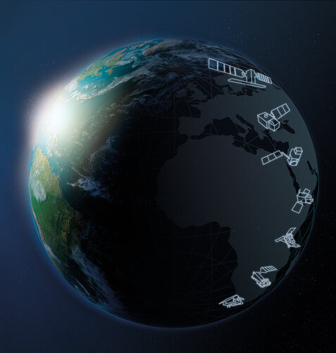
Following the financial commitment from ESA Member States at last November’s Council at Ministerial Level Space19+, ESA’s industrial policy committee has approved contracts totalling €2.55 billion to forward the development of six new Copernicus satellite missions, each mission comprising two satellites, a development and a recurrent unit.