


![]()

zprávy
zdroje zpráv:Rada/odborný rada - inspektor ZKI v Praze (obor služby 55.)
18.12.2024 12:11 ČÚZK - předpisy a opatření Zeměměřický a katastrální inspektorát v Prazevypisuje výběrové řízení na místo
Rada/odborný rada - inspektor ZKI v Praze (obor služby 55.)
Rada/odborný rada - inspektor ZKI v Praze (obor služby 55.)
18.12.2024 12:11 ČÚZK /Urady/Zememericke-a-katastralni-inspektoraty/Zememericke-a-katastralni-inspektoraty/Zememericky-a-katastralni-inspektorat-v-Praze/Uredni-deska/Oznameni-a-jina-uredni-sdeleni/Volna-mista/DMS/Rada-odborny-rada-inspektor-ZKI-v-Praze-(obor-sluzAlmanach geovědních pokusů, aneb vánoční dárek školám od „Vesmíru pro lidstvo“ (TZ)
18.12.2024 11:48 GISportal.cz
Pro vyučující, kteří chtějí zpestřit výuku hodin vlastivědy, přírodopisu nebo zeměpisu, připravili vědci zapojení do programu Akademie věd Strategie AV21 – Vesmír pro lidstvo vánoční dárek v podobě almanachu geovědních pokusů. Jedná se o soubor dvanácti jednoduchých experimentů, které umožní žákům základních a středních škol nahlédnout do fascinujícího světa geologie a tím lépe pochopit procesy, […]
The post Almanach geovědních pokusů, aneb vánoční dárek školám od „Vesmíru pro lidstvo“ (TZ) appeared first on GISportal.cz.
Almanach geovědních pokusů, aneb vánoční dárek školám od „Vesmíru pro lidstvo“ (TZ)
18.12.2024 11:48 GISportal.czPro vyučující, kteří chtějí zpestřit výuku hodin vlastivědy, přírodopisu nebo zeměpisu, připravili vědci zapojení do programu Akademie věd Strategie AV21 – Vesmír pro lidstvo vánoční dárek v podobě almanachu geovědních pokusů. Jedná se o soubor dvanácti jednoduchých experimentů, které umožní žákům základních a středních škol nahlédnout do fascinujícího světa geologie a tím lépe pochopit procesy, […]
The post Almanach geovědních pokusů, aneb vánoční dárek školám od „Vesmíru pro lidstvo“ (TZ) appeared first on GISportal.cz.
Klidné vánoční svátky a úspěšný nový rok 2025
17.12.2024 13:32 AdeonVážení zákazníci a partneři, rok 2024 se blíží ke svému závěru a my bychom Vám rádi poděkovali za Vaši důvěru, […]
The post Klidné vánoční svátky a úspěšný nový rok 2025 appeared first on Adeon CZ.
Referent/ka ZKN EX ID 90000119
17.12.2024 10:55 ČÚZK - předpisy a opatření Zeměměřický úřadvypisuje výběrové řízení na místo
Referent/ka ZKN EX ID 90000119
Referent/ka ZKN EX ID 90000119
17.12.2024 10:55 ČÚZK /Urady/Zememericky-urad/Uredni-deska/Oznameni-a-jina-uredni-sdeleni/Volna-mista/DMS/Referent-ka-ZKN-EX-ID-90000119Referent/ka ZKN EX ID 90000119
17.12.2024 10:55 Zeměměřický úřad Zeměměřický úřadvypisuje výběrové řízení na místo
Referent/ka ZKN EX ID 90000119
Referent/ka ZKN EX ID 90000119
17.12.2024 10:55 ČÚZK - volná místa Zeměměřický úřad vypisuje výběrové řízení na místo Referent/ka ZKN EX ID 90000119Geodet/ka EX ID 90000164
17.12.2024 10:53 ČÚZK - volná místa Zeměměřický úřad vypisuje výběrové řízení na místo Geodet/ka EX ID 90000164Geodet/ka EX ID 90000164
17.12.2024 10:53 ČÚZK /Urady/Zememericky-urad/Uredni-deska/Oznameni-a-jina-uredni-sdeleni/Volna-mista/DMS/Geodet-ka-EX-ID-90000164Geodet/ka EX ID 90000164
17.12.2024 10:53 Zeměměřický úřad Zeměměřický úřadvypisuje výběrové řízení na místo
Geodet/ka EX ID 90000164
Geodet/ka EX ID 90000164
17.12.2024 10:53 ČÚZK - předpisy a opatření Zeměměřický úřadvypisuje výběrové řízení na místo
Geodet/ka EX ID 90000164
Změna pracovní doby dne 23. 12. 2024
17.12.2024 10:50 ČÚZK /Urady/Katastralni-urady/Katastralni-urady/Katastralni-urad-pro-Liberecky-kraj/Katastralni-pracoviste/KP-Ceska-Lipa/O-uradu/Aktuality/Zmena-pracovni-doby-dne-23-12-2024Změna pracovní doby dne 23. 12. 2024
17.12.2024 10:50 ČÚZK - předpisy a opatření Katastrální úřad pro Liberecký kraj - Katastrální pracoviště Česká Lípa zveřejnil novou aktualitu: Dovolujeme si upozornit, že v pondělí dne 23. 12. 2024 budou všechna katastrální pracoviště Katastrálního úřadu pro Liberecký kraj otevřena pro veřejnost pouze v době od 8.00 do 14.00 hodin. Úřední hodiny v ostatních dnech do konce roku zůstávají beze změn.Děkujeme za pochopení.
Ing. Lubomír Týč
ředitel úřadu
odborného referenta / vrchního referenta v oddělení obnovy katastrálního operátu
17.12.2024 10:24 ČÚZK /Urady/Katastralni-urady/Katastralni-urady/Katastralni-urad-pro-Liberecky-kraj/Uredni-deska/Oznameni-a-jina-uredni-sdeleni/Volna-mista/odborneho-referenta-vrchniho-referenta-v-oddeleniodborného referenta / vrchního referenta v oddělení obnovy katastrálního operátu
17.12.2024 10:24 ČÚZK - předpisy a opatření Katastrální úřad pro Liberecký krajvypisuje výběrové řízení na místo odborného referenta / vrchního referenta v oddělení obnovy katastrálního operátu
odborného referenta / vrchního referenta v oddělení obnovy katastrálního operátu
odborného referenta / vrchního referenta v oddělení obnovy katastrálního operátu
17.12.2024 10:24 ČÚZK - volná místa Katastrální úřad pro Liberecký kraj vypisuje výběrové řízení na místo odborného referenta / vrchního referenta v oddělení obnovy katastrálního operátu
Nové číslo GaKO
17.12.2024 8:19
ÚGKK SR
Nové číslo časopisu Geodetického a Kartografického Obzoru 12/2024
Oznámení Katastrálního pracoviště Benešov
17.12.2024 6:51 ČÚZK - předpisy a opatření Katastrální úřad pro Středočeský kraj - Katastrální pracoviště Benešov zveřejnil novou aktualitu: Oznámení Katastrálního pracoviště BenešovZ technických důvodů nebude možné na katastrálním pracovišti Benešov v pátek 27. 12. 2024 platit v hotovosti.
Platbu za poskytnuté služby či podání však bude možné uskutečnit kolkovou známkou či platební kartou. Úhradu bude možné též provést na základě vystavení podkladu pro platbu. Stejně tak zůstává zachována možnost uvést do návrhu na vklad požadavek, aby byly některému z účastníků zaslány podklady pro platbu na zvolenou e-mailovou adresu.
Za případné komplikace se omlouváme.
Oznámení Katastrálního pracoviště Benešov
17.12.2024 6:51 ČÚZK - předpisy a opatření Katastrální úřad pro Středočeský kraj - Katastrální pracoviště Benešov zveřejnil novou aktualitu: Oznámení Katastrálního pracoviště BenešovZ technických důvodů nebude možné na katastrálním pracovišti Benešov v pátek 27. 12. 2024 a pondělí 30.12.2024 platit v hotovosti.
Platbu za poskytnuté služby či podání však bude možné uskutečnit kolkovou známkou či platební kartou. Úhradu bude možné též provést na základě vystavení podkladu pro platbu. Stejně tak zůstává zachována možnost uvést do návrhu na vklad požadavek, aby byly některému z účastníků zaslány podklady pro platbu na zvolenou e-mailovou adresu.
Za případné komplikace se omlouváme.
Oznámení Katastrálního pracoviště Benešov
17.12.2024 6:51 ČÚZK /Urady/Katastralni-urady/Katastralni-urady/Katastralni-urad-pro-Stredocesky-kraj/Katastralni-pracoviste/KP-Benesov/O-uradu/Aktuality/Oznameni-Katastralniho-pracoviste-BenesovOznámení Katastrálního pracoviště Benešov
17.12.2024 6:51 ČÚZK - předpisy a opatření Katastrální úřad pro Středočeský kraj - Katastrální pracoviště Benešov zveřejnil novou aktualitu: Oznámení Katastrálního pracoviště BenešovZ technických důvodů nebude možné na katastrálním pracovišti Benešov v úterý 30. 12. a ve středu 31. 12. 2025 platit v hotovosti.
Platbu za poskytnuté služby či podání však bude možné uskutečnit platební kartou. Úhradu bude možné též provést na základě vystavení podkladu pro platbu. Stejně tak zůstává zachována možnost uvést do návrhu na vklad požadavek, aby byly některému z účastníků zaslány podklady pro platbu na zvolenou e-mailovou adresu.
Za případné komplikace se omlouváme.
Změna pracovní doby 23.12. 2024
17.12.2024 6:45 ČÚZK - předpisy a opatření Katastrální úřad pro Liberecký kraj zveřejnil novou aktualitu: Dovolujeme si upozornit, že v pondělí dne 23. 12. 2024 budou všechna katastrální pracoviště Katastrálního úřadu pro Liberecký kraj otevřena pro veřejnost pouze v době od 8.00 do 14.00 hodin. Úřední hodiny v ostatních dnech do konce roku zůstávají beze změn.Děkujeme za pochopení.
Ing. Lubomír Týč
ředitel úřadu
Změna pracovní doby 23.12. 2024
17.12.2024 6:45 ČÚZK /Urady/Katastralni-urady/Katastralni-urady/Katastralni-urad-pro-Liberecky-kraj/O-uradu/Aktuality/Zmena-pracovni-doby-23-12-2024Oznámení Katastrálního úřadu pro Liberecký kraj
16.12.2024 17:12 ČÚZK /Urady/Katastralni-urady/Katastralni-urady/Katastralni-urad-pro-Liberecky-kraj/Katastralni-pracoviste/KP-Semily/O-uradu/Aktuality/Oznameni-Katastralniho-uradu-pro-Liberecky-krajOznámení Katastrálního úřadu pro Liberecký kraj
16.12.2024 17:12 ČÚZK - předpisy a opatření Český úřad zeměměřický a katastrální zveřejnil novou aktualitu: Oznámení Katastrálního úřadu pro Liberecký kraj, KP Semily.Dovolujeme si upozornit, že v pondělí dne 23. 12. 2024 budou všechna katastrální pracoviště Katastrálního úřadu pro Liberecký kraj otevřena pro veřejnost pouze v době od 8.00 do 14.00 hodin.Úřední hodiny v ostatních dnech do konce roku zůstávají beze změn.
Děkujeme za pochopení.
Ing. Lubomír Týč
ředitel úřadu
Oznámení Katastrálního úřadu pro Liberecký kraj
16.12.2024 17:12 ČÚZK - předpisy a opatření Český úřad zeměměřický a katastrální zveřejnil novou aktualitu: Oznámení Katastrálního úřadu pro Liberecký krajDovolujeme si upozornit, že v pondělí dne 23. 12. 2024
budou všechna katastrální pracoviště Katastrálního úřadu
pro Liberecký kraj otevřena pro veřejnost pouze v době
od 8.00 do 14.00 hodin.
Děkujeme za pochopení.
Ing. Lubomír Týč
ředitel úřadu
Oznámení Katastrálního úřadu pro Liberecký kraj
16.12.2024 17:12 ČÚZK - předpisy a opatření Český úřad zeměměřický a katastrální zveřejnil novou aktualitu: Oznámení Katastrálního úřadu pro Liberecký krajDovolujeme si upozornit, že v pondělí dne 23. 12. 2024 budou všechna katastrální pracoviště Katastrálního úřadu pro Liberecký kraj otevřena pro veřejnost pouze v době od 8.00 do 14.00 hodin.Úřední hodiny v ostatních dnech do konce roku zůstávají beze změn.
Děkujeme za pochopení.
Ing. Lubomír Týč
ředitel úřadu
Změna úředních hodin v prosinci 2024
16.12.2024 13:54 ČÚZK - předpisy a opatření Zeměměřický a katastrální inspektorát v Praze zveřejnil novou aktualitu: Vážení klienti,úřední hodiny pro veřejnost na Zeměměřickém a katastrálním inspektorátu v Praze budou v prosinci 2024 upraveny z provozních důvodů následovně:
pondělí 23.12.2024 : 8,00 - 12,00 hod.
pondělí 30.12.2024 : 8,00 - 13,00 hod.
úterý 31.12.2024 : 8,00 - 12,00 hod.
Děkujeme za pochopení.
Změna úředních hodin v prosinci 2024
16.12.2024 13:54 ČÚZK /Urady/Zememericke-a-katastralni-inspektoraty/Zememericke-a-katastralni-inspektoraty/Zememericky-a-katastralni-inspektorat-v-Praze/O-uradu/Aktuality/Zmena-urednich-hodin-v-prosinci-2024Informace o úpravě úředních hodin ve dnech 23.12. a 31.12.2024.
16.12.2024 13:01 ČÚZK - předpisy a opatření Zeměměřický a katastrální inspektorát v Opavě zveřejnil novou aktualitu: Informace o úpravě úředních hodin ve dnech 23.12. a 31.12.2024.Informace o úpravě úředních hodin ve dnech 23.12. a 31.12.2024.
16.12.2024 11:57 ČÚZK /Urady/Zememericke-a-katastralni-inspektoraty/Zememericke-a-katastralni-inspektoraty/Zememericky-a-katastralni-inspektorat-v-Opave/O-uradu/Aktuality/Informace-o-uprave-urednich-hodin-ve-dnech-23-12-aZměna úředních hodin v prosinci 2024
16.12.2024 9:39 ČÚZK /Urady/Zememericke-a-katastralni-inspektoraty/Zememericke-a-katastralni-inspektoraty/Zememericky-a-katastralni-inspektorat-v-Brne/O-uradu/Aktuality/Zmena-uredni-dobyZměna úředních hodin v prosinci 2024
16.12.2024 9:39 ČÚZK - předpisy a opatření Zeměměřický a katastrální inspektorát v Brně zveřejnil novou aktualitu: Vážení klienti,úřední hodiny pro veřejnost na Zeměměřickém a katastrálním inspektorátu v Brně budou v prosinci 2024 upraveny z provozních důvodů následovně:
pondělí 23. 12. 2024: 8,00 - 13,00
pondělí 30. 12. 2024: 8,00 - 13,00
úterý 31. 12. 2024: 8,00 - 12,00
Děkujeme za pochopení.
Rada/odborný rada – inspektor Zeměměřického a katastrálního inspektorátu v Brně obor služby 55
16.12.2024 9:13 ČÚZK - předpisy a opatření Zeměměřický a katastrální inspektorát v Brněvypisuje výběrové řízení na místo
Rada/odborný rada – inspektor Zeměměřického a katastrálního inspektorátu v Brně obor služby 55
Rada/odborný rada – inspektor Zeměměřického a katastrálního inspektorátu v Brně obor služby 55
16.12.2024 9:13 ČÚZK - volná místa Zeměměřický a katastrální inspektorát v Brně vypisuje výběrové řízení na místo Rada/odborný rada – inspektor Zeměměřického a katastrálního inspektorátu v Brně obor služby 55Rada/odborný rada – inspektor Zeměměřického a katastrálního inspektorátu v Brně obor služby 55
16.12.2024 9:13 ČÚZK /Urady/Zememericke-a-katastralni-inspektoraty/Zememericke-a-katastralni-inspektoraty/Zememericky-a-katastralni-inspektorat-v-Brne/Uredni-deska/Oznameni-a-jina-uredni-sdeleni/Volna-mista/rada-odborny-rada-–-inspektor-Zememerickeho-a-(1)APGEO - TERMÍNOVÁ REZERVACE VH APG 2025
16.12.2024 1:00 Asociace podnikatelů v geomatice TERMÍNOVÁ REZERVACE VH APG 2025APGEO - TERMÍNOVÁ REZERVACE NA VH APG A KONFERENCI GEOMATIKA 2025
16.12.2024 1:00 Asociace podnikatelů v geomatice TERMÍNOVÁ REZERVACE NA VH APG A KONFERENCI GEOMATIKA 2025APGEO - Střední průmyslová škola stavební Ostrava novým přidruženým členem apg.
16.12.2024 1:00 Asociace podnikatelů v geomatice SPŠ stavební Ostrava novým přidruženým členem APGAPGEO - České vysoké učení technické v Praze novým členem APG
16.12.2024 1:00 Asociace podnikatelů v geomatice ČVUT Praha se stalo novým přidruženým členem APG.APGEO - TERMÍNOVÁ REZERVACE NA VH APG A KONFERENCI GEOMATIKA 2025
16.12.2024 1:00 Asociace podnikatelů v geomatice Termínová rezervace na VH APG a konferenci Geomatika 2025.APGEO - České vysoké učení technické v Praze novým členem APG
16.12.2024 1:00 Asociace podnikatelů v geomatice České učení technické v Praze se stalo novým přidruženým členem APG.APGEO - VŠB Technická univerzita Ostrava novým přidruženým členem APG
16.12.2024 1:00 Asociace podnikatelů v geomatice VŠB Technická univerzita v Ostravě se stala novým přidruženým členem APG.APGEO - Horageo novým kmenovým členem APG
16.12.2024 1:00 Asociace podnikatelů v geomatice Společnost Horageo se stala novým kmenovým členem APG.APGEO - Střední průmyslová škola stavební Ostrava
16.12.2024 1:00 Asociace podnikatelů v geomatice SPŠ stavební Ostrava novým přidruženým členem APGPřejeme Vám pěkné vánoční svátky a štěstí a zdraví v roce 2025
15.12.2024 22:58 ŠPINAR - softwareVážení zákazníci,
dovolujeme si Vás informovat o technické podpoře po svátcích a v roce 2025.
Přejeme Vám pěkné vánoční svátky a štěstí a zdraví v roce 2025
15.12.2024 22:58 ŠPINAR - softwareVážení zákazníci,
dovolujeme si Vás informovat o technické podpoře po svátcích a v roce 2025.
The post Přejeme Vám pěkné vánoční svátky a štěstí a zdraví v roce 2025 appeared first on ŠPINAR – software.
APGEO - DEN GEOMATIKY OSTRAVA 2025
15.12.2024 1:00 Asociace podnikatelů v geomatice DEN GEOMATIKY OSTRAVA 2025GaKO 12/2024
14.12.2024 19:50 GaKO GaKO 12/2024 ŘEZNÍČEK, J.: 20 let provozu sítě permanentních stanic CZEPOSLeica Tour 2025 oznámila města a termíny
14.12.2024 18:17 ZeměměřičV prvních dvou březnových týdnech roku 2025 se, jako každoročně, uskuteční Leica Tour 2025. Firma Gefos, zástupce značky Leica Geosystems na českém trhu, bude informovat o novinkách, které značka přináší v geodetických přístrojích, 3D laserových skenerech a stavebních měřických přístrojích. Po 3.3.: Plzeň, Parkhotel Plzeň Congress Center Út 4.3.: Ústí nad Labem, Clarion Congress Hotel St 5.3.: České […]
The post Leica Tour 2025 oznámila města a termíny appeared first on Zeměměřič.
Setkání uživatelů. Zákazníci firmy Geoobchod se setkají v polovině ledna
14.12.2024 18:17 ZeměměřičLetošním hlavním tématem setkání bude sběr dat pro Digitální technickou mapu ČR. Pořadatelé pro vás připravují praktické ukázky, jak efektivně pracovat v terénu a plně využít stávající vybavení. Setkání se uskuteční ve dnech 14. a 15. ledna 2025 v hotelu Luna na Vysočině. V ceně účasti jsou přednášky, workshopy a školení, upgrade Transform MAX 1710 verze 8, jeden měsíc korekčních dat v síti […]
The post Setkání uživatelů. Zákazníci firmy Geoobchod se setkají v polovině ledna appeared first on Zeměměřič.
rada/odborný rada – správce ICT
13.12.2024 14:17 ČÚZK - předpisy a opatření Katastrální úřad pro hlavní město Prahu zveřejnil novou aktualitu: Ředitelka úřadu vyhlašuje výběrové řízení na pozici:rada/odborný rada – správce ICT
rada/odborný rada – správce ICT
13.12.2024 14:17 ČÚZK /Urady/Katastralni-urady/Katastralni-urady/Katastralni-urad-pro-hlavni-mesto-Prahu/O-uradu/Aktuality/rada-odborny-rada-–-spravce-ICT-(1)rada/odborný rada – správce ICT
13.12.2024 14:15 ČÚZK - volná místa Katastrální úřad pro hlavní město Prahu vypisuje výběrové řízení na místo rada/odborný rada – správce ICTrada/odborný rada – správce ICT
13.12.2024 14:15 ČÚZK /Urady/Katastralni-urady/Katastralni-urady/Katastralni-urad-pro-hlavni-mesto-Prahu/Uredni-deska/Oznameni-a-jina-uredni-sdeleni/Volna-mista/rada-odborny-rada-–-spravce-ICT-(1)rada/odborný rada – správce ICT
13.12.2024 14:15 ČÚZK - předpisy a opatření Katastrální úřad pro hlavní město Prahuvypisuje výběrové řízení na místo
rada/odborný rada – správce ICT
Krátka správa č. 47/2024
13.12.2024 14:07 Komora geodetů a kartografů SRThe post Krátka správa č. 47/2024 appeared first on Komora geodetov a kartografov.
Krátka správa č. 46/2024
13.12.2024 14:03 Komora geodetů a kartografů SRThe post Krátka správa č. 46/2024 appeared first on Komora geodetov a kartografov.
Krátka správa č. 45/2024
13.12.2024 13:31 Komora geodetů a kartografů SRThe post Krátka správa č. 45/2024 appeared first on Komora geodetov a kartografov.
Krátka správa č. 44/2024
13.12.2024 13:28 Komora geodetů a kartografů SRThe post Krátka správa č. 44/2024 appeared first on Komora geodetov a kartografov.
odborný/vrchní referent – poskytování informací KN a PK, poskytování podkladů, nahlížení do KN v odd
13.12.2024 13:22 ČÚZK - předpisy a opatření Katastrální úřad pro Jihočeský kraj Katastrální pracoviště České Budějovicevypisuje výběrové řízení na místo
odborný/vrchní referent – poskytování informací KN a PK, poskytování podkladů, nahlížení do KN v odd. dokumentace KN Katastrálního pracoviště Č. Budějovice (ID SM 30000146/30003770)
odborný/vrchní referent – poskytování informací KN a PK, poskytování podkladů, nahlížení do KN v odd
13.12.2024 13:22 ČÚZK - volná místa Katastrální úřad pro Jihočeský kraj Katastrální pracoviště České Budějovice vypisuje výběrové řízení na místo odborný/vrchní referent – poskytování informací KN a PK, poskytování podkladů, nahlížení do KN v oddodborný/vrchní referent – poskytování informací KN a PK, poskytování podkladů, nahlížení do KN v odd
13.12.2024 13:22 ČÚZK /Urady/Katastralni-urady/Katastralni-urady/Katastralni-urad-pro-Jihocesky-kraj/Uredni-deska/Oznameni-a-jina-uredni-sdeleni/Volna-mista/DMS/odborny-vrchni-referent-–-poskytovani-informac-(1)Aliance přivítala zástupce Industrial Technology Research Institute z Taiwanu
13.12.2024 11:13 UAVA Tento týden představil prezident Aliance její aktivity zástupcům Industrial Technology Research Institute z Taiwanu. Součástí jejich návštěvy bylo koordinované setkání se čtyřmi předem vybranými členy Aliance a začátkem příštího roku bude následovat početnější delegace tohoto institutu do ČR. #ITRIClive Billiald Steps Down as CEO of buildingSMART International
13.12.2024 11:00 buildingSMART.orgIt is with mixed emotions that we announce the departure of Clive Billiald from buildingSMART International (bSI). After two years as our CEO, Clive has decided to pursue new opportunities and challenges elsewhere. During his time at bSI, Clive has had a significant and positive impact across both our organization and our community as…
The post Clive Billiald Steps Down as CEO of buildingSMART International appeared first on buildingSMART International.
Clive Billiald Steps Down as CEO of buildingSMART International
13.12.2024 11:00 buildingSMART.orgThe post Clive Billiald Steps Down as CEO of buildingSMART International appeared first on buildingSMART International.
Clive Billiald Steps Down as CEO of buildingSMART International
13.12.2024 11:00 buildingSMART.orgIt is with mixed emotions that we announce the departure of Clive Billiald from buildingSMART International (bSI). After two years as our CEO, Clive has decided to pursue new…
The post Clive Billiald Steps Down as CEO of buildingSMART International appeared first on buildingSMART International.
Join ESA FutureNAV Industry Day 2025
13.12.2024 10:04 ESA Navigation
The first FutureNAV Industry Day, on 18 February 2025, will bring together European stakeholders in satellite navigation to explore the future of positioning, navigation and timing (PNT) technologies. This gathering will spotlight emerging opportunities and foster a network of European companies in the PNT and GNSS sector. Don't miss this chance - secure your spot by registering here.
Earth from Space: Jakobshavn Glacier, Greenland
13.12.2024 10:00 ESA Observing the Earth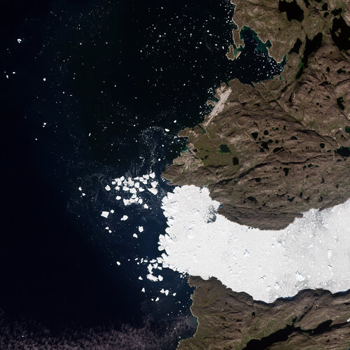 Image:
These summer images from the Copernicus Sentinel-2 and Sentinel-1 missions showcase different satellite views of Greenland’s west coast.
Image:
These summer images from the Copernicus Sentinel-2 and Sentinel-1 missions showcase different satellite views of Greenland’s west coast.
odborný/vrchní referent – poskytování informací KN a PK, poskytování podkladů, nahlížení do KN v odd
13.12.2024 9:51 ČÚZK - předpisy a opatření Katastrální úřad pro Jihočeský kraj Katastrální pracoviště České Budějovicevypisuje výběrové řízení na místo
odborný/vrchní referent – poskytování informací KN a PK, poskytování podkladů, nahlížení do KN v oddělení dokumentace KN Katastrálního pracoviště České Budějovice
odborný/vrchní referent – poskytování informací KN a PK, poskytování podkladů, nahlížení do KN v odd
13.12.2024 9:51 ČÚZK - volná místa Katastrální úřad pro Jihočeský kraj Katastrální pracoviště České Budějovice vypisuje výběrové řízení na místo odborný/vrchní referent – poskytování informací KN a PK, poskytování podkladů, nahlížení do KN v oddInformace o úpravě úředních hodin dne 23.12.2024 a úhradě správních poplatků v závěru roku.
13.12.2024 8:14 ČÚZK - předpisy a opatření Katastrální úřad pro Olomoucký kraj zveřejnil novou aktualitu: Informace o úpravě úředních hodin dne 23.12.2024 a úhradě správních poplatků v závěru roku.Informace o úpravě úředních hodin dne 23.12.2024 a úhradě správních poplatků v závěru roku.
13.12.2024 8:14 ČÚZK /Urady/Katastralni-urady/Katastralni-urady/Katastralni-urad-pro-Olomoucky-kraj/O-uradu/Aktuality/Informace-o-uprave-urednich-hodin-dne-23-12-2024-aInformace o úpravě úředních hodin dne 23.12.2024 a úhradě správních poplatků v závěru roku.
13.12.2024 8:14 ČÚZK - předpisy a opatření Katastrální úřad pro Olomoucký kraj zveřejnil novou aktualitu: Informace o úpravě úředních hodin dne 23.12.2024 a úhradě správních poplatků v závěru roku.Nové letecké snímky v aplikaci Archiv
13.12.2024 8:00 ČÚZK - Geoportál Nové letecké snímky v aplikaci ArchivAplikace Archiv byla doplněna o nově naskenované archivní letecké měřické snímky z let 1972 a 1973.
Nové letecké snímky v aplikaci Archiv
13.12.2024 8:00 ČÚZK - Geoportál Nové letecké snímky v aplikaci ArchivAplikace Archiv byla doplněna o nově naskenované archivní letecké měřické snímky z let 1972 a 1973.
Nové letecké snímky v aplikaci Archiv
13.12.2024 8:00 ČÚZK - Geoportál Nové letecké snímky v aplikaci ArchivAplikace Archiv byla doplněna o nově naskenované archivní letecké měřické snímky z let 1972 a 1973.
Nové letecké snímky v aplikaci Archiv
13.12.2024 8:00 ČÚZK - Geoportál Nové letecké snímky v aplikaci ArchivAplikace Archiv byla doplněna o nově naskenované archivní letecké měřické snímky z let 1972 a 1973.
Nové letecké snímky v aplikaci Archiv
13.12.2024 8:00 ČÚZK - Geoportál Nové letecké snímky v aplikaci ArchivAplikace Archiv byla doplněna o nově naskenované archivní letecké měřické snímky z let 1972 a 1973.
Nové letecké snímky v aplikaci Archiv
13.12.2024 8:00 ČÚZK - Geoportál Nové letecké snímky v aplikaci ArchivAplikace Archiv byla doplněna o nově naskenované archivní letecké měřické snímky z let 1972 a 1973.
Nové letecké snímky v aplikaci Archiv
13.12.2024 8:00 ČÚZK - Geoportál Nové letecké snímky v aplikaci ArchivAplikace Archiv byla doplněna o nově naskenované archivní letecké měřické snímky z let 1972 a 1973.
Nové letecké snímky v aplikaci Archiv
13.12.2024 8:00 ČÚZK - Geoportál Nové letecké snímky v aplikaci ArchivAplikace Archiv byla doplněna o nově naskenované archivní letecké měřické snímky z let 1972 a 1973.
Nové letecké snímky v aplikaci Archiv
13.12.2024 8:00 ČÚZK - Geoportál Nové letecké snímky v aplikaci ArchivAplikace Archiv byla doplněna o nově naskenované archivní letecké měřické snímky z let 1972 a 1973.
Nové letecké snímky v aplikaci Archiv
13.12.2024 8:00 ČÚZK - Geoportál Nové letecké snímky v aplikaci ArchivAplikace Archiv byla doplněna o nově naskenované archivní letecké měřické snímky z let 1972 a 1973.
Nové letecké snímky v aplikaci Archiv
13.12.2024 8:00 ČÚZK - Geoportál Nové letecké snímky v aplikaci ArchivAplikace Archiv byla doplněna o nově naskenované archivní letecké měřické snímky z let 1972 a 1973.
Nové letecké snímky v aplikaci Archiv
13.12.2024 8:00 ČÚZK - Geoportál Nové letecké snímky v aplikaci ArchivAplikace Archiv byla doplněna o nově naskenované archivní letecké měřické snímky z let 1972 a 1973.
Nové letecké snímky v aplikaci Archiv
13.12.2024 8:00 ČÚZK - Geoportál Nové letecké snímky v aplikaci ArchivAplikace Archiv byla doplněna o nově naskenované archivní letecké měřické snímky z let 1972 a 1973.
Nové letecké snímky v aplikaci Archiv
13.12.2024 8:00 ČÚZK - Geoportál Nové letecké snímky v aplikaci ArchivAplikace Archiv byla doplněna o nově naskenované archivní letecké měřické snímky z let 1972 a 1973.
Nové letecké snímky v aplikaci Archiv
13.12.2024 8:00 ČÚZK - Geoportál Nové letecké snímky v aplikaci ArchivAplikace Archiv byla doplněna o nově naskenované archivní letecké měřické snímky z let 1972 a 1973.
Nové letecké snímky v aplikaci Archiv
13.12.2024 8:00 ČÚZK - Geoportál Nové letecké snímky v aplikaci ArchivAplikace Archiv byla doplněna o nově naskenované archivní letecké měřické snímky z let 1972 a 1973.
Nové letecké snímky v aplikaci Archiv
13.12.2024 8:00 ČÚZK - Geoportál Nové letecké snímky v aplikaci ArchivAplikace Archiv byla doplněna o nově naskenované archivní letecké měřické snímky z let 1972 a 1973.
Nové letecké snímky v aplikaci Archiv
13.12.2024 8:00 ČÚZK - Geoportál Nové letecké snímky v aplikaci ArchivAplikace Archiv byla doplněna o nově naskenované archivní letecké měřické snímky z let 1972 a 1973.
Nové letecké snímky v aplikaci Archiv
13.12.2024 8:00 ČÚZK - Geoportál Nové letecké snímky v aplikaci ArchivAplikace Archiv byla doplněna o nově naskenované archivní letecké měřické snímky z let 1972 a 1973.
Nové letecké snímky v aplikaci Archiv
13.12.2024 8:00 ČÚZK - Geoportál Nové letecké snímky v aplikaci ArchivAplikace Archiv byla doplněna o nově naskenované archivní letecké měřické snímky z let 1972 a 1973.
Nové letecké snímky v aplikaci Archiv
13.12.2024 8:00 ČÚZK - Geoportál Nové letecké snímky v aplikaci ArchivAplikace Archiv byla doplněna o nově naskenované archivní letecké měřické snímky z let 1972 a 1973.
Nové letecké snímky v aplikaci Archiv
13.12.2024 8:00 ČÚZK - Geoportál Nové letecké snímky v aplikaci ArchivAplikace Archiv byla doplněna o nově naskenované archivní letecké měřické snímky z let 1972 a 1973.
Nové letecké snímky v aplikaci Archiv
13.12.2024 8:00 ČÚZK - Geoportál Nové letecké snímky v aplikaci ArchivAplikace Archiv byla doplněna o nově naskenované archivní letecké měřické snímky z let 1972 a 1973.
Nové letecké snímky v aplikaci Archiv
13.12.2024 8:00 ČÚZK - Geoportál Nové letecké snímky v aplikaci ArchivAplikace Archiv byla doplněna o nově naskenované archivní letecké měřické snímky z let 1972 a 1973.
Na TimeMap.org je 500 tisíc starých map. Petr Přidal představil novou verzi OldMapsOnline
12.12.2024 17:17 GeoBusiness Veřejné spuštění nové verze OldMapsOnline s TimeMap.org proběhlo v David Rumsey Map Center na Stanfordově univerzitě. Petr Přidal, zakladatel a majitel firmy MapTiler, představil technické detaily projektu TimeMap.org a poté diskutovali s Davidem Rumseyem, správcem kartografické sbírky. Na serveru ProductHunt je projekt prezentován jako „Google Mapy historie“. Countries of the past, rulers and kings, battles, […]Na TimeMap.org je 500 tisíc starých map. Petr Přidal představil novou verzi OldMapsOnline přímo v mapovém centru Davida Rumseyho
12.12.2024 17:17 GeoBusiness Veřejné spuštění nové verze OldMapsOnline s TimeMap.org proběhlo v David Rumsey Map Center na Stanfordově univerzitě. Petr Přidal, zakladatel a majitel firmy MapTiler, představil technické detaily projektu TimeMap.org a poté diskutovali s Davidem Rumseyem, správcem kartografické sbírky. Na serveru ProductHunt je projekt prezentován jako „Google Mapy historie“. Countries of the past, rulers and kings, battles, […]Na TimeMap.org je 500 tisíc starých map. Petr Přidal představil novou verzi OldMapsOnline
12.12.2024 17:17 GeoBusinessVeřejné spuštění nové verze OldMapsOnline s TimeMap.org proběhlo v David Rumsey Map Center na Stanfordově univerzitě. Petr Přidal, zakladatel a majitel firmy MapTiler, představil technické detaily projektu TimeMap.org a poté diskutovali s Davidem Rumseyem, správcem kartografické sbírky. Na serveru ProductHunt je projekt prezentován jako „Google Mapy historie“. Countries of the past, rulers and kings, battles, […]
The post Na TimeMap.org je 500 tisíc starých map. Petr Přidal představil novou verzi OldMapsOnline appeared first on GeoBusiness.
rada/odborný rada – rozhodování o povolení vkladu v oddělení právních vztahů k nemovitostem Katastrá
12.12.2024 14:38 ČÚZK - předpisy a opatření Katastrální úřad pro Jihočeský kraj Katastrální pracoviště Jindřichův Hradecvypisuje výběrové řízení na místo
rada/odborný rada – rozhodování o povolení vkladu v oddělení právních vztahů k nemovitostem Katastrálního pracoviště Jindřichův Hradec (ID SM 30000180/30003804)
odborný referent / vrchní referent v oddělení obnovy katastrálního operátu (3010) Katastrálního úřad
12.12.2024 12:08 ČÚZK /Urady/Katastralni-urady/Katastralni-urady/Katastralni-urad-pro-Pardubicky-kraj/Uredni-deska/Oznameni-a-jina-uredni-sdeleni/Volna-mista/DMS/odborny-referent-vrchni-referent-v-oddeleni-obnovyodborný referent / vrchní referent v oddělení obnovy katastrálního operátu (3010) Katastrálního úřad
12.12.2024 12:08 ČÚZK - volná místa Katastrální úřad pro Pardubický kraj odbor obnovy katastrálního operátu vypisuje výběrové řízení na místo odborný referent / vrchní referent v oddělení obnovy katastrálního operátu (3010) Katastrálního úřadodborný referent / vrchní referent v oddělení obnovy katastrálního operátu (3010) Katastrálního úřad
12.12.2024 12:08 ČÚZK - předpisy a opatření Katastrální úřad pro Pardubický kraj odbor obnovy katastrálního operátuvypisuje výběrové řízení na místo
odborný referent / vrchní referent v oddělení obnovy katastrálního operátu (3010) Katastrálního úřadu pro Pardubický kraj
Informace o úpravě úředních hodin ve dnech 23.12. a 31.12.2024
12.12.2024 8:38 ČÚZK - předpisy a opatření Český úřad zeměměřický a katastrální zveřejnil novou aktualitu: Informace o úpravě úředních hodin ve dnech 23.12. a 31.12.2024.Informace o úpravě úředních hodin ve dnech 23.12. a 31.12.2024
12.12.2024 8:38 ČÚZK /Urady/Katastralni-urady/Katastralni-urady/Katastralni-urad-pro-Karlovarsky-kraj/O-uradu/Aktuality/Informace-o-uprave-urednich-hodin-ve-dnech-23-12-aHigh-altitude balloon ride offers new perspective for CAIRT
12.12.2024 8:30 ESA Observing the Earth
A novel sensor that simulates the measurements that would be taken by one of the proposed satellites vying to be ESA’s eleventh Earth Explorer, has endured an extraordinary journey.
Carried aboard a high-altitude balloon on a four-day voyage from Sweden to Canada, the sensor provides new data that could help to refine the CAIRT mission concept – a mission that aims to unravel the complexities of Earth's atmosphere and enhance our understanding of climate dynamics.
Program osmé konference o GISech v plánování měst a regionů
11.12.2024 20:30 GeoBusinessGIS V PLÁNOVÁNÍ MĚST A REGIONŮ 2025 (23.1.2025 v Praze) Česká asociace pro geoinformace a Masarykův ústav vyšších studií ČVUT v Praze zvou na osmý ročník konference „GIS v plánování měst a regionů“. Akce se uskuteční v Praze dne 23. ledna 2025. Tématem letošního ročníku je „územní plánování na všech stupních“. Program konference GIS v […]
The post Program osmé konference o GISech v plánování měst a regionů appeared first on GeoBusiness.
Program osmé konference o GIS v plánování měst a regionů
11.12.2024 20:30 GeoBusiness Česká asociace pro geoinformace a Masarykův ústav vyšších studií ČVUT v Praze zvou na osmý ročník konference „GIS v plánování měst a regionů“. Akce se uskuteční v Praze dne 23. ledna 2025. Tématem letošního ročníku je „územní plánování na všech stupních“. Program konference GIS v plánování měst a regionů Zahájení konference – prof. PhDr. Vladimíra […]Program osmé konference o GIS v plánování měst a regionů
11.12.2024 20:30 GeoBusinessČeská asociace pro geoinformace a Masarykův ústav vyšších studií ČVUT v Praze zvou na osmý ročník konference „GIS v plánování měst a regionů“. Akce se uskuteční v Praze dne 23. ledna 2025. Tématem letošního ročníku je „územní plánování na všech stupních“. Program konference GIS v plánování měst a regionů Zahájení konference – prof. PhDr. Vladimíra […]
The post Program osmé konference o GIS v plánování měst a regionů appeared first on GeoBusiness.
AI-powered satellite data reveals clouds in 3D
11.12.2024 14:45 ESA Observing the Earth
Launched in May 2024, ESA’s EarthCARE satellite is nearing the end of its commissioning phase with the release of its first data on clouds and aerosols expected early next year. In the meantime, an international team of scientists has found an innovative way of applying artificial intelligence to other satellite data to yield 3D profiles of clouds.
This is particularly news for those eagerly awaiting data from EarthCARE in their quest to advance climate science.
Další nový profesor geovědního oboru
11.12.2024 10:13 GISportal.cz
Na návrh Vědecké rady Ostravské univerzity jmenoval prezident Petr Pavel geografa Jana Ženku profesorem pro obor: Politická a kulturní geografie. Gratulujeme!
The post Další nový profesor geovědního oboru appeared first on GISportal.cz.
Další nový profesor geovědního oboru
11.12.2024 10:13 GISportal.czNa návrh Vědecké rady Ostravské univerzity jmenoval prezident Petr Pavel geografa Jana Ženku profesorem pro obor: Politická a kulturní geografie. Gratulujeme!
The post Další nový profesor geovědního oboru appeared first on GISportal.cz.
První radarové snímky z družice Sentinel-1C ukazují Špicberky, Nizozemsko a Brusel
10.12.2024 22:00 GeoBusinessMéně než týden po vypuštění dodala družice Copernicus Sentinel-1C první radarové snímky Země, které nabízejí pohled na její schopnosti monitorování životního prostředí. Úvodní snímky zahrnují Špicberky v Norsku, Nizozemsko a Brusel. Družice Sentinel-1C byla vypuštěna 5. prosince z evropského kosmodromu ve Francouzské Guyaně na raketě Vega-C. Je vybavena radarem s technologií C-pásma typu Synthetic Aperture […]
The post První radarové snímky z družice Sentinel-1C ukazují Špicberky, Nizozemsko a Brusel appeared first on GeoBusiness.