


zprávy
zdroje zpráv:BlackSky Expands Constellation to 14 Satellites and Increases Capacity Over Critical Locations
5.4.2022 3:25 GISCafe.com Webcasts-Webinars HERNDON, Va. — (BUSINESS WIRE) — April 4, 2022 —BlackSky's (NYSE: BKSY) newest satellites successfully began revenue-generating …
Hexagon helps Electricity Company of Ghana modernize electricity distribution
4.4.2022 19:00 Hexagon Safety & InfrastructureTeal Drones Secures Purchase Order for Golden Eagle Drone Units from NATO Member Country for Deployment in Ukraine
4.4.2022 16:01 GISCafe.com Webcasts-Webinars SAN JUAN, Puerto Rico, April 04, 2022 (GLOBE NEWSWIRE) -- Red Cat Holdings, Inc. (Nasdaq: RCAT) ("Red Cat" or the "Company"), a hardware-enabled …BlackSky Appoints Top Defense and Intelligence Experts to New Advisory Group
4.4.2022 16:01 GISCafe.com Webcasts-Webinars Prominent leaders from the Intelligence Community and the Department of Defense: U.S. Army, U.S. Navy, and U.S. Space Force to provide strategic …Esri Releases Annual Update of Ready-to-Use US Census Bureau Data for ArcGIS Users
4.4.2022 16:01 GISCafe.com Webcasts-Webinars Updated American Community Survey Data Is Available in ArcGIS Living AtlasREDLANDS, Calif. — (BUSINESS WIRE) — April 4, 2022 …
Satellogic Launches Five Additional Satellites on SpaceX Transporter-4 Mission
4.4.2022 16:01 GISCafe.com Webcasts-Webinars Leading Vertically-Integrated Geospatial Company Expands its Fleet to 22 SatellitesNEW YORK — (BUSINESS WIRE) — April 4, 2022 …
EARTH OVERSHOOT LAUNCHES "MVP" SUSTAINABLE COUNTRY MAP
4.4.2022 16:01 GISCafe.com Webcasts-Webinars PHILADELPHIA, April 4, 2022 — (PRNewswire) — Earth Overshoot (EO) today unveiled its "MVP" Sustainability Map, a new online educational …Woolpert Contracted By USGS To Conduct Geophysical Surveys Related To Critical Minerals, Energy Research, Hazard Assessments In Arkansas
4.4.2022 16:01 GISCafe.com Webcasts-Webinars DANVILLE, Ark., April 4, 2022 — (PRNewswire) — The U.S. Geological Survey (USGS) has contracted with Woolpert to conduct a …Nová verze popisu služeb
4.4.2022 15:39 ČÚZK - předpisy a opatření V záložce Popis služeb byla zveřejněna aktualizovaná verze dokumentu Popis a technické parametry služeb IS DMVSNová verze popisu služeb
4.4.2022 15:39 ČÚZK - předpisy a opatření V záložce Popis rozhraní byla zveřejněna aktualizovaná verze dokumentu Popis a technické parametry služeb IS DMVSNová verze popisu služeb
4.4.2022 15:39 ČÚZK - předpisy a opatření V záložce Popis rozhraní byla zveřejněna aktualizovaná verze dokumentu Popis a technické parametry služeb IS DMVSOdborný rada v oddělení právních vztahů k nemovitostem na Katastrálním pracovišti Znojmo
4.4.2022 13:20 ČÚZK - volná místa Katastrální úřad pro Jihomoravský kraj Katastrální pracoviště Znojmo vypisuje výběrové řízení na místo Odborný rada v oddělení právních vztahů k nemovitostem na Katastrálním pracovišti ZnojmoOdborný rada v oddělení právních vztahů k nemovitostem na Katastrálním pracovišti Znojmo
4.4.2022 13:20 ČÚZK - předpisy a opatření Katastrální úřad pro Jihomoravský kraj Katastrální pracoviště Znojmovypisuje výběrové řízení na místo
Odborný rada v oddělení právních vztahů k nemovitostem na Katastrálním pracovišti Znojmo
Odborný rada v oddělení právních vztahů k nemovitostem na Katastrálním pracovišti Znojmo
4.4.2022 13:20 ČÚZK /Urady/Katastralni-urady/Katastralni-urady/Katastralni-urad-pro-Jihomoravsky-kraj/Volna-mista/DMS/Odborny-rada-v-oddeleni-pravnich-vztahu-k-nemovitoVandalové z neznalosti ničí práci geodetů
4.4.2022 12:25 ZeměměřičNa silnicích druhých a třetích tříd v Olomouckém kraji se objevily vlícovací a kontrolní body pro mobilní mapování. Všimli si jich nejen řidiči, ale také vandalové, kteří některé z nich přetřeli černou barvou. Začerněno bylo několik desítek vlícovacích bodů, které si firma TopGis kvůli mobilnímu mapování na vozovkách připravila. Pořízení snímků komunikací je součástí projektu vytvoření digitálně technické mapy […]
The post Vandalové z neznalosti ničí práci geodetů appeared first on Zeměměřič.
Space-based solutions set to address some of today’s most pressing challenges
4.4.2022 11:45 European GNSS Agency
Having received 50 proposals, the first Horizon Europe call is set to turn space technologies like Galileo, EGNOS and Copernicus into innovative applications and solutions.
The results of the first Horizon Europe call are in, with the European Union Agency for the Space Programme (EUSPA), who manages the call, receiving 50 proposals.
While the proposals come from across Europe, each shares the common goal of developing innovative downstream solutions that leverage data and information from the EU Space Programme, including Galileo, EGNOS and Copernicus.
“Linking space to user needs starts with research and innovation,” says EUSPA Head of Market Development Innovation department, Fiammetta Diani. “By facilitating research that leverages the EU Space Programme, Horizon Europe supports the development of space-based solutions to some of today’s most pressing challenges.”
Those challenges are transforming the digital economy, improving safety and security services and mitigating the risk of climate change – and the proposals received for this first call address all three.
For instance, for the Digital Age, EUSPA received 10 innovative applications proposals focusing on this particular topic. Taking advantage of European GNSS’ (EGNSS) superb multipath resistance and authentication, these proposals look to address a range of societal challenges, including health and wellbeing, smart mobility and the sharing economy.
EUSPA also received 12 proposals for using Earth Observation and EGNSS to better protect European citizens from natural disasters and other emergencies. Many of these proposals, highlight the important of timing and synchronisation services offered by Galileo. “In the unfortunate event of wildfires, floods or earthquakes, having ready access to precise location and up-to-date geospatial information are vital to conducting an effective emergency response,” says Diani. “The synergies between Copernicus, Galileo and EGNOS have the potential to offer just that, and these proposals aim to turn that potential into practical solutions.”
As to mitigating the risk of climate change, the first call received 28 proposals for using EGNSS and Earth Observation data to support the objectives of the EU’s Green Deal. “From curbing CO2 emissions to fighting illegal logging, monitoring biodiversity and tracking oil spills, Galileo, EGNOS and Copernicus are essential tools for delivering on the Green Deal’s ambitious environmental goals,” adds Diani.
The total indicative budget allocated for these first call proposals is EUR 32.6 million.
The second Horizon Europe call is planned to be opened for submissions in October 2022. With an overall budget of EUR 48.1 million, this second call will focus on supporting the development of innovative space-based downstream applications.
Media note: This feature can be republished without charge provided the European Union Agency for the Space Programme (EUSPA) is acknowledged as the source at the top or the bottom of the story. You must request permission before you use any of the photographs on the site. If you republish, we would be grateful if you could link back to the EUSPA website (http://www.euspa.europa.eu).
20220404_Rada / odborný rada oddělení právních vztahů k nemovitostem
4.4.2022 8:46 ČÚZK /Urady/Katastralni-urady/Katastralni-urady/Katastralni-urad-pro-Stredocesky-kraj/Katastralni-pracoviste/KP-Rakovnik/O-uradu/Aktuality/20210922_Odborny-referent-oddeleni-aktualizace-(4)20220404_Rada / odborný rada oddělení právních vztahů k nemovitostem
4.4.2022 8:46 ČÚZK - předpisy a opatření Katastrální úřad pro Středočeský kraj - Katastrální pracoviště Rakovník Vyhlášení výběrového řízení: Rada / odborný rada oddělení právních vztahů k nemovitostem V části "Úřední deska", v sekci "Oznámení a jiná úřední sdělení" bylo vystaveno "Oznámení o vyhlášení výběrového řízení na obsazení služebního místa Rada / odborný rada oddělení právních vztahů k nemovitostem"Aktualizace dat - Císařské otisky stabilního katastru
4.4.2022 7:40 Jihočeský krajMísta na Vitorazsku s chybějícími císařskými povinnými otisky stabilního katastru byla doplněna originálními mapami stabilního katastru z pozdějšího období získaných z rakouského Bundesamt für Eich- und Vermessungswesen (BEV).
HawkEye 360 Launches Next-Generation Cluster 4 Satellites
3.4.2022 16:19 GISCafe.com Webcasts-Webinars HERNDON, Va., April 1, 2022 — (PRNewswire) — HawkEye 360 Inc., the world's leading commercial provider of space-based radio frequency …Rocket Lab Launches 112th Satellite to Orbit
3.4.2022 16:19 GISCafe.com Webcasts-Webinars MAHIA, New Zealand — (BUSINESS WIRE) — April 2, 2022 —Rocket Lab USA, Inc (Nasdaq: RKLB), a leading launch and space systems …
Orbit Logic Awarded Lunar Swarms Autonomy NASA Phase II STTR
1.4.2022 21:29 GISCafe.com Webcasts-Webinars GREENBELT, MD ( March 29 , 2022) – Orbit Logic has been awarded a Phase II Small Business Technology Transfer (STTR) contract by NASA to …Energy Assets Select MGISS For Geospatial Services Provision
1.4.2022 17:21 GISCafe.com Webcasts-Webinars April 01, 2022 -- Dynamic multi-utility service network adopter Energy Assets Networks and Pipelines (EAN & P) recently won grant funding from …Nearmap Challenges Validity of EagleView/Pictometry Patents
1.4.2022 17:21 GISCafe.com Webcasts-Webinars SALT LAKE CITY, April 01, 2022 (GLOBE NEWSWIRE) -- Nearmap has filed three inter partes reviews against EagleView/Pictometry which relate …Launch of Kleos’ Patrol Mission Satellites Targeted for 1st April (UTC)
1.4.2022 16:21 GISCafe.com Webcasts-Webinars Kleos Space S.A, a space-powered Radio Frequency Reconnaissance data-as-a-service (DaaS) company, is advised that their four Patrol Mission (KSF2) …Amnesty International Partners With Planet to Tackle Deforestation in Cambodia
1.4.2022 16:20 GISCafe.com Webcasts-Webinars SAN FRANCISCO — (BUSINESS WIRE) — April 1, 2022 —Planet Labs PBC (NYSE: PL), a leading provider of daily data and insights about …
WSDP - aktualizace dokumentace
1.4.2022 14:10 Dálkový přístup k údajům KN ČR Vážení uživatelé webových služeb dálkového přístupu,byla zveřejněna nová verze dokumentace WSDP v2.9. Hlavní změnou je úprava XSD pro sestavy, kde dochází úpravě v elementu <OKRES>. Dokumentace je vystavena zde: https://cuzk.cz/Katastr-nemovitosti/Poskytovani-udaju-z-KN/Dalkovy-pristup/Webove-sluzby-dalkoveho-pristupu.aspx
Změna bude nasazena s novou verzí ISKN v polovině dubna.
WSDP - aktualizace dokumentace
1.4.2022 14:10 ČÚZK - předpisy a opatření Vážení uživatelé webových služeb dálkového přístupu,byla zveřejněna nová verze dokumentace WSDP v2.9. Hlavní změnou je úprava XSD pro sestavy, kde dochází úpravě v elementu <OKRES>. Dokumentace je vystavena zde: https://cuzk.cz/Katastr-nemovitosti/Poskytovani-udaju-z-KN/Dalkovy-pristup/Webove-sluzby-dalkoveho-pristupu.aspx
Změna bude nasazena s novou verzí ISKN v polovině dubna.
WSDP - aktualizace dokumentace
1.4.2022 14:10 ČÚZK /Aplikace-DP-do-KN/Aplikace-DP-do-KN/Archiv-DP/351948WSDP - aktualizace dokumentace
1.4.2022 14:10 ČÚZK - předpisy a opatření Vážení uživatelé webových služeb dálkového přístupu,byla zveřejněna nová verze dokumentace WSDP v2.9. Hlavní změnou je úprava XSD pro sestavy, kde dochází úpravě v elementu <OKRES>. Dokumentace je vystavena zde: https://cuzk.cz/Katastr-nemovitosti/Poskytovani-udaju-z-KN/Dalkovy-pristup/Webove-sluzby-dalkoveho-pristupu.aspx
Změna bude nasazena s novou verzí ISKN v polovině dubna.
WSDP - aktualizace dokumentace
1.4.2022 14:10 Dálkový přístup k údajům KN ČR Vážení uživatelé webových služeb dálkového přístupu,byla zveřejněna nová verze dokumentace WSDP v2.9. Hlavní změnou je úprava XSD pro sestavy, kde dochází úpravě v elementu <OKRES>. Dokumentace je vystavena zde: https://cuzk.cz/Katastr-nemovitosti/Poskytovani-udaju-z-KN/Dalkovy-pristup/Webove-sluzby-dalkoveho-pristupu.aspx
Změna bude nasazena s novou verzí ISKN v polovině dubna.
WSGP-termín ukončení provozu služeb v.2.8
1.4.2022 12:24 ČÚZK - RSS kanál pro zeměměřiče Vážení uživatelé webových služeb pro vyhotovitele a ověřovatele geometrických plánů, předpokládaný termín ukončení provozu webových služeb pro vyhotovitele a ověřovatele geometrických plánů verze 2.8 je 14.4.2022. Od 14.4.2022 budou v provozu pouze webové služby pro vyhotovitele a ověřovatele geometrických plánů verze 2.9 a zároveň bude upraven export a import VFK. Nově bude umožněno pouze kódování UTF-8.WSGP-termín ukončení provozu služeb v.2.8
1.4.2022 12:24 ČÚZK - předpisy a opatření Český úřad zeměměřický a katastrálnízveřejnil novou aktualitu: Vážení uživatelé webových služeb pro vyhotovitele a ověřovatele geometrických plánů, předpokládaný termín ukončení provozu webových služeb pro vyhotovitele a ověřovatele geometrických plánů verze 2.8 je 14.4.2022. Od 14.4.2022 budou v provozu pouze webové služby pro vyhotovitele a ověřovatele geometrických plánů verze 2.9 a zároveň bude upraven export a import VFK. Nově bude umožněno pouze kódování UTF-8.
WSGP-termín ukončení provozu služeb v.2.8
1.4.2022 12:24 ČÚZK /Zememerictvi/Zememericke-cinnosti/Aktuality-pro-zememerice/2022/WSGP-termin-ukonceni-provozu-sluzeb-v-2-8Inženýrské sítě a jejich ochranná pásma
1.4.2022 12:11 GISportal.cz
Umístění technické infrastruktury, zejména liniových staveb a jejich příslušenství, je dnes standardem v geoinformačních portálech měst a obcí. Ne vždy jsou však zpracovány všechny inženýrské sítě nacházející se v obci, případně nejsou jejich trasy po rozšíření aktualizovány. Spoléhat se na zakreslení inženýrských sítí v GIS je obecně problematické. Ačkoli je jejich umístění v GIS zaneseno většinou přesně, aktuálnost […]
The post Inženýrské sítě a jejich ochranná pásma appeared first on GISportal.cz.
vrchní referent/rada - obnova katastrálního operátu v oddělení aktualizace KN Katastrálního pracoviš
1.4.2022 12:07 ČÚZK /Urady/Katastralni-urady/Katastralni-urady/Katastralni-urad-pro-Jihocesky-kraj/Uredni-deska/Oznameni-a-jina-uredni-sdeleni/Volna-mista/DMS/vrchni-referent-rada-obnova-katastralniho-operatvrchní referent/rada - obnova katastrálního operátu v oddělení aktualizace KN Katastrálního pracoviš
1.4.2022 12:07 ČÚZK - předpisy a opatření Katastrální úřad pro Jihočeský kraj Katastrální pracoviště Strakonicevypisuje výběrové řízení na místo
vrchní referent/rada - obnova katastrálního operátu v oddělení aktualizace KN Katastrálního pracoviště Strakonice (ID SM 30000361/30087122)
vrchní referent/rada - obnova katastrálního operátu v oddělení aktualizace KN Katastrálního pracoviš
1.4.2022 12:07 ČÚZK - volná místa Katastrální úřad pro Jihočeský kraj Katastrální pracoviště Strakonice vypisuje výběrové řízení na místo vrchní referent/rada - obnova katastrálního operátu v oddělení aktualizace KN Katastrálního pracovišOznámení o vyhlášení výběrového řízení – ředitel Kanceláře ředitele Katastrálního úřadu
1.4.2022 10:45 ČÚZK /Urady/Katastralni-urady/Katastralni-urady/Katastralni-urad-pro-Plzensky-kraj/O-uradu/Aktuality/Oznameni-o-vyhlaseni-vyberoveho-rizeni-–-reditel-KOznámení o vyhlášení výběrového řízení – ředitel Kanceláře ředitele Katastrálního úřadu
1.4.2022 10:45 ČÚZK - předpisy a opatření Katastrální úřad pro Plzeňský kraj zveřejnil novou aktualitu: Oznámení o vyhlášení výběrového řízení na služební místo rada/odborný rada – ředitel Kanceláře ředitele Katastrálního úřadu, Katastrální úřad pro Plzeňský kraj, Kancelář ředitele Katastrálního úřaduOznámení o vyhlášení výběrového řízení na služební místo rada/odborný rada – ředitel Kanceláře ředit
1.4.2022 10:31 ČÚZK - volná místa Katastrální úřad pro Plzeňský kraj kancelář ředitele vypisuje výběrové řízení na místo Oznámení o vyhlášení výběrového řízení na služební místo rada/odborný rada – ředitel Kanceláře ředitOznámení o vyhlášení výběrového řízení na služební místo rada/odborný rada – ředitel Kanceláře ředit
1.4.2022 10:21 ČÚZK - předpisy a opatření Katastrální úřad pro Plzeňský kraj kancelář ředitelevypisuje výběrové řízení na místo
Oznámení o vyhlášení výběrového řízení na služební místo rada/odborný rada – ředitel Kanceláře ředitele Katastrálního úřadu, Katastrální úřad pro Plzeňský kraj, Kancelář ředitele Katastrálního úřadu
Oznámení o vyhlášení výběrového řízení na služební místo rada/odborný rada – ředitel Kanceláře ředit
1.4.2022 10:21 ČÚZK /Urady/Katastralni-urady/Katastralni-urady/Katastralni-urad-pro-Plzensky-kraj/Uredni-deska/Oznameni-a-jina-uredni-sdeleni/Volna-mista/DMS/Oznameni-o-vyhlaseni-vyberoveho-rizeni-na-sluzebniEarth from Space: Barranquilla, Colombia
1.4.2022 10:00 ESA Observing the Earth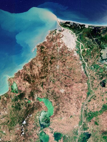
Barranquilla, the capital of the Atlántico department in northwest Colombia, is featured in this image taken by the Copernicus Sentinel-2 mission.
Nová verze aplikace Holixa T4R pro Revit
1.4.2022 9:52 Arkance SystemsUvádíme novou verzi aplikace Holixa T4R pro Revit, dříve známé pod názvem Tools for Revit nebo Revit Tools.
Zpráva Nová verze aplikace Holixa T4R pro Revit pochází z arkance-systems.cz.
20220401 - Nový speciální VFR s ÚÚP - dobývacími prostory
1.4.2022 9:40 ČÚZK /ruian/Novinky-RUIAN/Archiv-novinek-RUIAN/2022/20220401-Novy-specialni-VFR-s-UUP-dobyvacimi-pAgEagle to Host Fourth Quarter and Full Year 2021 Corporate Update on Tuesday, April 12, 2022 at 4:30 PM ET
1.4.2022 9:00 GISCafe.com Webcasts-Webinars WICHITA, Kan., March 31, 2022 (GLOBE NEWSWIRE) -- AgEagle Aerial Systems Inc. (NYSE American: UAVS) (“AgEagle” or the …20220401 - Nový speciální VFR s ÚÚP - dobývacími prostory
1.4.2022 8:26 ČÚZK /ruian/Poskytovani-udaju-ISUI-RUIAN-VDP/Vymenny-format-RUIAN-(VFR)/Archiv-novinek-VFR/2022/20220401-Novy-specialni-VFR-s-UUP-dobyvacimi-pAutel Robotics Drones Win Best of the Best of Red Dot Design Awards 2022
1.4.2022 2:33 GISCafe.com Webcasts-Webinars News Highlightsâ— Autel wins Red Dot awards
â— EVO Lite+ and EVO Nano+ drones named Best of the …
Trans-Atlantic team to develop technical concept for NATO’s Future Surveillance and Control capabilities
1.4.2022 2:29 GISCafe.com Webcasts-Webinars #NATO #ASPAARO @AirbusDefence @NorthropGrummanMunich / Falls Church, Va, 31 March 2022 – Airbus Defence and Space together with Northrop …
Planet Reports Financial Results for Fourth Quarter and Full Year of Fiscal 2022
1.4.2022 1:45 GISCafe.com Webcasts-Webinars Delivers Record Fourth Quarter Revenue of $37.1 Million and Full Year Revenue of $131.2 MillionExpands YoY Fourth Quarter GAAP Gross Margin from …
Intermap Files 2021 Annual Results
1.4.2022 1:45 GISCafe.com Webcasts-Webinars DENVER, March 31, 2022 — (PRNewswire) — Intermap Technologies (TSX: IMP) (OTCQX: ITMSF) ("Intermap" or the "Company"), a global leader …UltraMatch, the new revolutionary photogrammetry processing and LiDAR Geo-referencing software
31.3.2022 16:44 GISCafe.com Webcasts-Webinars March 31, 2022 -- MetaSpatial Solutions Pty Ltd., an Australian Geospatial Technology company, announced today the release of new cutting-edge …TomTom Partners with MIH Consortium
31.3.2022 16:20 GISCafe.com Webcasts-Webinars AMSTERDAM, March 31, 2022 (GLOBE NEWSWIRE) -- TomTom (TOM2), the geolocation technology specialist, today announced that it has joined the MIH …Kratos Demonstrates All-Digital Multi-Mission Edge Capability at the 37th Space Symposium
31.3.2022 16:20 GISCafe.com Webcasts-Webinars SAN DIEGO, March 31, 2022 (GLOBE NEWSWIRE) -- Kratos Defense & Security Solutions, Inc. (Nasdaq: KTOS), a leading National Security Solutions …Dvacátý Agrihub INSPIRE Hackathon 2022 v dubnu a květnu
31.3.2022 16:02 GeoBusinessAgriHub INSPIRE Hackathon je dvacátý ročník INSPIRE Hackathonu, který organizuje Plan4All, letos v rámci projektu AgriHub CZ&SK financovaného z projektu SmartAgriHubs H2020. Vychází z tradičního modelu INSPIRE Hackathonu, což znamená, že se nejedná o jednorázovou akci, ale o proces zaměřený na efektivní využití výsledků předchozích hackathonů zaměřených na vývoj nových inovací. V rámci tohoto hackathonu […]
The post Dvacátý Agrihub INSPIRE Hackathon 2022 v dubnu a květnu appeared first on GeoBusiness.
rada/odborný rada - rozhodování o povolení vkladu v právním oddělení Katastrálního pracoviště České
31.3.2022 14:01 ČÚZK - předpisy a opatření Katastrální úřad pro Jihočeský kraj Katastrální pracoviště České Budějovicevypisuje výběrové řízení na místo
rada/odborný rada - rozhodování o povolení vkladu v právním oddělení Katastrálního pracoviště České Budějovice (ID SM 30000095/30003719)
Chráněno: DTM ČR - největší geomatický projekt posledních let
31.3.2022 13:29 T-MAPYStručný obsah příspěvku zde není uveden, protože je tento příspěvek chráněn heslem.
The post Chráněno: DTM ČR - největší geomatický projekt posledních let appeared first on T-MAPY spol. s r.o..
vrchní referent/rada - kontrola listin určených k záznamu v oddělení právních vztahů k nemovitostem
31.3.2022 13:17 ČÚZK /Urady/Katastralni-urady/Katastralni-urady/Katastralni-urad-pro-Jihocesky-kraj/Uredni-deska/Oznameni-a-jina-uredni-sdeleni/Volna-mista/DMS/vrchni-referent-rada-kontrola-listin-urcenych-kvrchní referent/rada - kontrola listin určených k záznamu v oddělení právních vztahů k nemovitostem
31.3.2022 13:17 ČÚZK - předpisy a opatření Katastrální úřad pro Jihočeský kraj Katastrální pracoviště Prachaticevypisuje výběrové řízení na místo
vrchní referent/rada - kontrola listin určených k záznamu v oddělení právních vztahů k nemovitostem Katastrálního pracoviště Prachatice (ID SM 30000260/30003884)
vrchní referent/rada - kontrola listin určených k záznamu v oddělení právních vztahů k nemovitostem
31.3.2022 13:17 ČÚZK - volná místa Katastrální úřad pro Jihočeský kraj Katastrální pracoviště Prachatice vypisuje výběrové řízení na místo vrchní referent/rada - kontrola listin určených k záznamu v oddělení právních vztahů k nemovitostemSave the date: EUSpace4Ukraine humanitarian help webinar on 12 April
31.3.2022 12:58 European GNSS Agency
The European Union, its Member States, and Europeans across the continent have joined efforts to support Ukrainians fleeing the devastating war. EUSPA is mobilizing the EU Space innovation community who can provide solutions to enhance humanitarian support for Ukraine people. We are creating a platform to match the innovators with the NGOs and other helpers.
If you are a start-up, an innovator, an NGO or a helper providing humanitarian support for Ukraine, save the date for our webinar on 12 April - 10:00 am - 11:00 am, to discover how you can be part of the platform and the upcoming opportunities!
Register here.
Meanwhile, EUSPA, being a user-oriented agency is currently setting up a first version of the platform grouping applications and solutions that leverage freely accessible data of Galileo and Copernicus to enhance humanitarian support for Ukraine people. In the webinar you will discover how to contribute to growing this first platform.
The applications/solutions will cover a wide range of uses, from supporting NGOs delivering medical goods via drones to practical solutions to support the integration in EU countries of people fleeing the war.
Media note: This feature can be republished without charge provided the European Union Agency for the Space Programme (EUSPA) is acknowledged as the source at the top or the bottom of the story. You must request permission before you use any of the photographs on the site. If you republish, we would be grateful if you could link back to the EUSPA website (http://www.euspa.europa.eu).
Save the date: EUSpace4Ukraine humanitarian help webinar on 12 April
31.3.2022 12:58 European GNSS AgencyEUSPA to mobilise the EU Space innovation community and provide solutions to enhance humanitarian support for the Ukrainian people.
The European Union, its Member States, and Europeans across the continent have joined efforts to support Ukrainians fleeing the devastating war. EUSPA is mobilizing the EU Space innovation community who can provide solutions to enhance humanitarian support for Ukraine people. We are creating a platform to match the innovators with the NGOs and other helpers.
If you are a start-up, an innovator, an NGO or a helper providing humanitarian support for Ukraine, save the date for our webinar on 12 April - 10:00 am - 11:00 am, to discover how you can be part of the platform and the upcoming opportunities!
Register here.
Meanwhile, EUSPA, being a user-oriented agency is currently setting up a first version of the platform grouping applications and solutions that leverage freely accessible data of Galileo and Copernicus to enhance humanitarian support for Ukraine people. In the webinar you will discover how to contribute to growing this first platform.
The applications/solutions will cover a wide range of uses, from supporting NGOs delivering medical goods via drones to practical solutions to support the integration in EU countries of people fleeing the war.
Media note: This feature can be republished without charge provided the European Union Agency for the Space Programme (EUSPA) is acknowledged as the source at the top or the bottom of the story. You must request permission before you use any of the photographs on the site. If you republish, we would be grateful if you could link back to the EUSPA website (http://www.euspa.europa.eu).
Save the date: EUSpace4Ukraine humanitarian help webinar on 12 April
31.3.2022 12:58 European GNSS Agency
The European Union, its Member States, and Europeans across the continent have joined efforts to support Ukrainians fleeing the devastating war. EUSPA is mobilizing the EU Space innovation community who can provide solutions to enhance humanitarian support for Ukraine people. We are creating a platform to match the innovators with the NGOs and other helpers.
If you are a start-up, an innovator, an NGO or a helper providing humanitarian support for Ukraine, save the date for our webinar on 12 April - 10:00 am - 11:00 am, to discover how you can be part of the platform and the upcoming opportunities!
Register here.
Meanwhile, EUSPA, being a user-oriented agency is currently setting up a first version of the platform grouping applications and solutions that leverage freely accessible data of Galileo and Copernicus to enhance humanitarian support for Ukraine people. In the webinar you will discover how to contribute to growing this first platform.
The applications/solutions will cover a wide range of uses, from supporting NGOs delivering medical goods via drones to practical solutions to support the integration in EU countries of people fleeing the war.
Media note: This feature can be republished without charge provided the European Union Agency for the Space Programme (EUSPA) is acknowledged as the source at the top or the bottom of the story. You must request permission before you use any of the photographs on the site. If you republish, we would be grateful if you could link back to the EUSPA website (http://www.euspa.europa.eu).
Save the date: EUSpace4Ukraine humanitarian help webinar on 12 April
31.3.2022 12:58 European GNSS AgencyEUSPA to mobilise the EU Space innovation community and provide solutions to enhance humanitarian support to those fleeing the war.
The European Union, its Member States, and Europeans across the continent have joined efforts to support people fleeing the devastating war. EUSPA is mobilizing the EU Space innovation community who can provide solutions to enhance humanitarian support. We are creating a platform to match the innovators with the NGOs and other helpers.
If you are a start-up, an innovator, an NGO or a helper providing humanitarian support for Ukraine, save the date for our webinar on 12 April - 10:00 am - 11:00 am, to discover how you can be part of the platform and the upcoming opportunities!
Meanwhile, EUSPA, being a user-oriented agency is currently setting up a first version of the platform grouping applications and solutions that leverage freely accessible data of Galileo and Copernicus to enhance humanitarian support for Ukraine people. In the webinar you will discover how to contribute to growing this first platform.
The applications/solutions will cover a wide range of uses, from supporting NGOs delivering medical goods via drones to practical solutions to support the integration in EU countries of people fleeing the war.
Media note: This feature can be republished without charge provided the European Union Agency for the Space Programme (EUSPA) is acknowledged as the source at the top or the bottom of the story. You must request permission before you use any of the photographs on the site. If you republish, we would be grateful if you could link back to the EUSPA website (http://www.euspa.europa.eu).
Save the date: EUSpace4Ukraine humanitarian help webinar on 12 April
31.3.2022 12:58 European GNSS AgencyEUSPA to mobilise the EU Space innovation community and provide solutions to enhance humanitarian support for the Ukrainian people.
The European Union, its Member States, and Europeans across the continent have joined efforts to support Ukrainians fleeing the devastating war. EUSPA is mobilizing the EU Space innovation community who can provide solutions to enhance humanitarian support for Ukrainian people. We are creating a platform to match the innovators with the NGOs and other helpers.
If you are a start-up, an innovator, an NGO or a helper providing humanitarian support for Ukraine, save the date for our webinar on 12 April - 10:00 am - 11:00 am, to discover how you can be part of the platform and the upcoming opportunities!
Meanwhile, EUSPA, being a user-oriented agency is currently setting up a first version of the platform grouping applications and solutions that leverage freely accessible data of Galileo and Copernicus to enhance humanitarian support for Ukraine people. In the webinar you will discover how to contribute to growing this first platform.
The applications/solutions will cover a wide range of uses, from supporting NGOs delivering medical goods via drones to practical solutions to support the integration in EU countries of people fleeing the war.
Media note: This feature can be republished without charge provided the European Union Agency for the Space Programme (EUSPA) is acknowledged as the source at the top or the bottom of the story. You must request permission before you use any of the photographs on the site. If you republish, we would be grateful if you could link back to the EUSPA website (http://www.euspa.europa.eu).
Save the date: EUSpace4Ukraine humanitarian help webinar on 12 April
31.3.2022 12:58 European GNSS AgencyEUSPA to mobilise the EU Space innovation community and provide solutions to enhance humanitarian support to those fleeing the war.
The European Union, its Member States, and Europeans across the continent have joined efforts to support people fleeing the devastating war. EUSPA is mobilizing the EU Space innovation community who can provide solutions to enhance humanitarian support. We are creating a platform to match the innovators with the NGOs and other helpers.
If you are a start-up, an innovator, an NGO or a helper providing humanitarian support for Ukraine, save the date for our webinar on 12 April - 10:00 am - 11:00 am, to discover how you can be part of the platform and the upcoming opportunities!
Meanwhile, EUSPA, being a user-oriented agency is currently setting up a first version of the platform grouping applications and solutions that leverage freely accessible data of Galileo and Copernicus to enhance humanitarian support for Ukraine people. In the webinar you will discover how to contribute to growing this first platform.
The applications/solutions will cover a wide range of uses, from supporting NGOs delivering medical goods via drones to practical solutions to support the integration in EU countries of people fleeing the war.
Media note: This feature can be republished without charge provided the European Union Agency for the Space Programme (EUSPA) is acknowledged as the source at the top or the bottom of the story. You must request permission before you use any of the photographs on the site. If you republish, we would be grateful if you could link back to the EUSPA website (http://www.euspa.europa.eu).
Save the date: EUSpace4Ukraine humanitarian help webinar on 12 April
31.3.2022 12:58 European GNSS AgencyEUSPA to mobilise the EU Space innovation community and provide solutions to enhance humanitarian support for the Ukrainian people.
The European Union, its Member States, and Europeans across the continent have joined efforts to support Ukrainians fleeing the devastating war. EUSPA is mobilizing the EU Space innovation community who can provide solutions to enhance humanitarian support for Ukraine people. We are creating a platform to match the innovators with the NGOs and other helpers.
If you are a start-up, an innovator, an NGO or a helper providing humanitarian support for Ukraine, save the date for our webinar on 12 April - 10:00 am - 11:00 am, to discover how you can be part of the platform and the upcoming opportunities!
Meanwhile, EUSPA, being a user-oriented agency is currently setting up a first version of the platform grouping applications and solutions that leverage freely accessible data of Galileo and Copernicus to enhance humanitarian support for Ukraine people. In the webinar you will discover how to contribute to growing this first platform.
The applications/solutions will cover a wide range of uses, from supporting NGOs delivering medical goods via drones to practical solutions to support the integration in EU countries of people fleeing the war.
Media note: This feature can be republished without charge provided the European Union Agency for the Space Programme (EUSPA) is acknowledged as the source at the top or the bottom of the story. You must request permission before you use any of the photographs on the site. If you republish, we would be grateful if you could link back to the EUSPA website (http://www.euspa.europa.eu).
odborný referent – obnova katastrálního operátu 3010
31.3.2022 12:24 ČÚZK - volná místa Katastrální úřad pro Olomoucký kraj - technický odbor vypisuje výběrové řízení na místo odborný referent – obnova katastrálního operátu 3010odborný referent – obnova katastrálního operátu 3010
31.3.2022 12:24 ČÚZK - předpisy a opatření Katastrální úřad pro Olomoucký kraj - technický odborvypisuje výběrové řízení na místo
odborný referent – obnova katastrálního operátu 3010
odborný referent – obnova katastrálního operátu 3010
31.3.2022 12:24 ČÚZK /Urady/Katastralni-urady/Katastralni-urady/Katastralni-urad-pro-Olomoucky-kraj/Uredni-deska/Oznameni-a-jina-uredni-sdeleni/Volna-mista/odborny-referent-–-obnova-katastralniho-operatu-30MawisPhoto se představuje také v zahraničí
31.3.2022 11:08 Hrdlička Služba zaujala nejen tuzemské i zahraniční zákazníky.Harmony in the Wadden
31.3.2022 9:30 ESA Observing the Earth
An important milestone in the development of ESA’s tenth Earth Explorer satellite mission, Harmony, has been reached thanks to two aircraft flying in tight formation over the Dutch Wadden Islands collecting key data on sea state and currents. The main purpose of this tricky airborne experiment is to mimic the geometry at which the Harmony satellites will measure various aspects of ocean dynamics to understand how air and the ocean surface interact, which, in turn, will improve weather prediction and climate models.
Harmony in the Wadden
31.3.2022 9:30 ESA Observing the Earth
An important milestone in the preparation of ESA’s tenth Earth Explorer candidate satellite mission, Harmony, has been reached thanks to two aircraft flying in tight formation over the Dutch Wadden Islands collecting key data on sea state and currents. The main purpose of this tricky airborne experiment is to mimic the geometry at which the Harmony satellites will measure various aspects of ocean dynamics to understand how air and the ocean surface interact, which, in turn, will improve weather prediction and climate models.
Rozpočet úřadu za rok 2022
31.3.2022 7:30 ČÚZK /Urady/Katastralni-urady/Katastralni-urady/Katastralni-urad-pro-Vysocinu/Rozpocet/Rozpocet-uradu-za-rok-2022Rozpočet úřadu za rok 2022
31.3.2022 7:30 ČÚZK - předpisy a opatření Katastrální úřad pro Vysočinuvystavuje rozpočet úřadu za rok
2022
Cities discuss uniform European regulations at ADW Hybrid
31.3.2022 2:08 GISCafe.com Webcasts-Webinars Amsterdam, 30 March 2022Cities discuss uniform European regulations at ADW HybridFirst event at RAI Amsterdam since COVID regulations eased
The …
Maxar : Satellite Images 29 March 2022: Mariupol, Ukraine
31.3.2022 2:01 GISCafe.com Webcasts-Webinars Images 01-02: Overview and close views of downtown Mariupol showing extensive damage at and near Mariupol Theater (Location: 47.096, …Esri and Stone Environmental Join to Help Expand Vermont Broadband Access
30.3.2022 17:17 GISCafe.com Webcasts-Webinars Communications Union Districts Will Use GIS Technology to Address State's Digital DivideREDLANDS, Calif. — (BUSINESS WIRE) — March 30, …
Hexagon publishes the Annual Report and Sustainability Report 2021
30.3.2022 17:17 GISCafe.com Webcasts-Webinars NACKA STRAND, Sweden, March 30, 2022 — (PRNewswire) — Hexagon's Annual Report 2021 and separate Sustainability Report is now …FedEx Plans to Test Autonomous Drone Cargo Delivery with Elroy Air
30.3.2022 17:17 GISCafe.com Webcasts-Webinars FedEx and Elroy Air work to launch test flights aimed at middle-mile delivery in 2023MEMPHIS, Tenn. — (BUSINESS WIRE) — March 30, 2022 …
Airobotics is proceeding towards Type Certification of its automated drone system after final airworthiness criteria was published by the FAA
30.3.2022 17:17 GISCafe.com Webcasts-Webinars PETAH TIKVA, Israel, March 30, 2022 — (PRNewswire) — AIROBOTICS (TASE: AIRO) An Israeli manufacturer of autonomous Unmanned …BIM Technology Delivers a Green and Smart Cement Factory
30.3.2022 16:38 Bentley SystemsPressCoverage
Process-worldwide, DACH
Read the articleNVIDIA Omniverse Ecosystem Expands 10x
30.3.2022 16:31 Bentley SystemsPressCoverage
Nvidia, USA
Read the articlePhotogrammetry for ground surveys a promising ally
30.3.2022 16:25 Bentley SystemsPressCoverage
CIMA+, USA
Read the articleGreg Estes interview What to expect at Nvidias GTC event
30.3.2022 16:18 Bentley SystemsPressCoverage
VentureBeat, USA
Read the articleConnecting the virtual and physical worlds
30.3.2022 16:07 Bentley SystemsPressCoverage
ME Construction News, Middle East
Read the articleUpozornění pro uživatele GEUS 25.0
30.3.2022 16:01 GEUSware Bylo publikováno poslední sestavení GEUS 25.0, ve kterém jsou zprovozněny funkce "Nahlížení do KN".Life Cycle Assessment and Embodied Carbon Calculation Capabilities
30.3.2022 16:00 Bentley SystemsPressCoverage
ABC Magazine, Southern Europe
Read the articleDigital Twin Technology Transforming the Asset Lifecycle For Construction
30.3.2022 15:53 Bentley SystemsPressCoverage
IOT For All, USA
Read the articleJourney to Destination Earth begins
30.3.2022 15:40 ESA Observing the Earth
Today, the European Commission, ESA, the European Centre for Medium-Range Weather Forecasts (ECMWF) and the European Organisation for the Exploitation of Meteorological Satellites (Eumetsat) celebrated the official launch of the Destination Earth initiative: an ambitious project that involves creating a digital replica of Earth to help us move towards a sustainable future.
Open-source technology for infrastructure digital twins
30.3.2022 15:38 Bentley SystemsPressCoverage
EPC World and Construction Week, USA
Read the articleVyhlášení platnosti obnoveného katastrálního operátu v kat. území Dolní Sytová
30.3.2022 14:15 ČÚZK /Urady/Katastralni-urady/Katastralni-urady/Katastralni-urad-pro-Liberecky-kraj/Katastralni-pracoviste/KP-Semily/O-uradu/Aktuality/Vyhlaseni-platnosti-obnoveneho-katastralniho-operaVyhlášení platnosti obnoveného katastrálního operátu v kat. území Dolní Sytová
30.3.2022 14:15 ČÚZK - předpisy a opatření Katastrální úřad pro Liberecký kraj - Katastrální pracoviště Semilyzveřejnil novou aktualitu: Dne 29. 3. 2022 byla v kat. území Dolní Sytová vyhlášena platnost obnoveného katastrálního operátu přepracováním na části katastrálního území.
Úpravna vody – vodní nádrž Vír
30.3.2022 14:07 Hrdlička Vytvořili jsme BIM model areálu v okolí vírské přehrady.Odborný / vrchní referent v oddělení aktualizace Katastrálního pracoviště Hradec Králové
30.3.2022 12:03 ČÚZK - předpisy a opatření Katastrální úřad pro Královéhradecký kraj Katastrální pracoviště Hradec Královévypisuje výběrové řízení na místo
Odborný / vrchní referent v oddělení aktualizace Katastrálního pracoviště Hradec Králové
Odborný / vrchní referent v oddělení aktualizace Katastrálního pracoviště Hradec Králové
30.3.2022 12:03 ČÚZK - volná místa Katastrální úřad pro Královéhradecký kraj Katastrální pracoviště Hradec Králové vypisuje výběrové řízení na místo Odborný / vrchní referent v oddělení aktualizace Katastrálního pracoviště Hradec KrálovéOdborný / vrchní referent v oddělení aktualizace Katastrálního pracoviště Hradec Králové
30.3.2022 12:03 ČÚZK /Urady/Katastralni-urady/Katastralni-urady/Katastralni-urad-pro-Kralovehradecky-kraj/Volna-mista/DMS/Odborny-vrchni-referent-v-oddeleni-aktualizace-KJarní promo sleva 25 % na Autodesk Fusion 360 a Fusion Extensions
30.3.2022 12:00 Arkance SystemsZískejte 30% slevu na předplatné oblíbeného produktu Fusion 360 i jeho sedmi funkčních rozšíření. Jen do konce ledna 2022.
Zpráva Jarní promo sleva 25 % na Autodesk Fusion 360 a Fusion Extensions pochází z arkance-systems.cz.
Jarní promo sleva 25 % na Autodesk Fusion 360 a Fusion Extensions
30.3.2022 12:00 Arkance SystemsVyužijte slevovou akci na Fusion 360 a na všech 7 funkčních rozšíření aplikace - Fusion Extensions. Jen do 20. dubna 2022.
Zpráva Jarní promo sleva 25 % na Autodesk Fusion 360 a Fusion Extensions pochází z arkance-systems.cz.
20220330_Odborný referent oddělení právních vztahů k nemovitostem
30.3.2022 11:09 ČÚZK - předpisy a opatření Katastrální úřad pro Středočeský kraj - Katastrální pracoviště Mladá Boleslav Vyhlášení výběrového řízení: Odborný referent oddělení právních vztahů k nemovitostem V části "Úřední deska", v sekci "Oznámení a jiná úřední sdělení" bylo vystaveno "Oznámení o vyhlášení výběrového řízení na obsazení systemizovaného místa Odborný referent oddělení právních vztahů k nemovitostem"20220330_Odborný referent oddělení právních vztahů k nemovitostem
30.3.2022 11:09 ČÚZK /Urady/Katastralni-urady/Katastralni-urady/Katastralni-urad-pro-Stredocesky-kraj/Katastralni-pracoviste/KP-Mlada-Boleslav/O-uradu/Aktuality/20210113_odborny-rada,-reditel-Katastralniho-p-(3)Odborný referent oddělení právních vztahů k nemovitostem
30.3.2022 11:07 ČÚZK - volná místa Katastrální úřad pro Středočeský kraj - Katastrální pracoviště Mladá Boleslav vypisuje výběrové řízení na místo Odborný referent oddělení právních vztahů k nemovitostemOdborný referent oddělení právních vztahů k nemovitostem
30.3.2022 11:07 ČÚZK - předpisy a opatření Katastrální úřad pro Středočeský kraj - Katastrální pracoviště Mladá Boleslavvypisuje výběrové řízení na místo Odborný referent oddělení právních vztahů k nemovitostem
Odborný referent oddělení právních vztahů k nemovitostem
Odborný referent oddělení právních vztahů k nemovitostem
30.3.2022 11:07 ČÚZK /Urady/Katastralni-urady/Katastralni-urady/Katastralni-urad-pro-Stredocesky-kraj/Uredni-deska/Oznameni-a-jina-uredni-sdeleni/Volna-mista/Odborny-referent-oddeleni-pravnich-vztahu-k-ne-(3)OSN chce do pěti let vytvořit celosvětový systém včasného varování před extrémním počasím
30.3.2022 8:27 GeoBusinessOrganizace spojených národů představila u příležitosti Světového meteorologického dne 23. března ambiciózní cíl. Během následujících pěti let by měli být všichni lidé na Zemi chráněni systémy včasného varování před extrémním počasím, uvádí se v tiskové zprávě. Světová meteorologická organizace vydala atlas, mapující období 1970 až 2019. V publikaci WMO Atlas of Mortality and Economic Losses […]
The post OSN chce do pěti let vytvořit celosvětový systém včasného varování před extrémním počasím appeared first on GeoBusiness.
Paradigm Geospatial Inc. Joins NVIDIA Inception
30.3.2022 1:17 GISCafe.com Webcasts-Webinars SAN DIEGO — (BUSINESS WIRE) — March 29, 2022 —Paradigm Geospatial Inc. today announced it has joined NVIDIA Inception, a program …
Commercial UAV Expo Announces 120+ Exhibitors to Date for Las Vegas Event
29.3.2022 21:53 GISCafe.com Webcasts-Webinars PORTLAND, Maine, March 29, 2022 — (PRNewswire) —Exhibit space expanded to accommodate overwhelming demand as best-in-class UAS …
Jakou roli hrají mapy v krizové komunikaci. V Liberci se koná konference HealthGIS
29.3.2022 21:04 GeoBusinessTechnická univerzita v Liberci a Krajská hygienická stanice v Liberci pořádají konferenci HealthGIS. Akce se koná ve dnech 7. a 8. dubna 2022. Veřejné zdraví a instituce, které o něj pečující, se v uplynulých dvou letech díky pandemii covid-19 setkávaly s novými zkušenostmi. Ty přicházely díky velké dynamice a intenzitě epidemie, stejně jako v souvislosti […]
The post Jakou roli hrají mapy v krizové komunikaci. V Liberci se koná konference HealthGIS appeared first on GeoBusiness.
S&P CORELOGIC CASE-SHILLER INDEX REPORTS 19.2% ANNUAL HOME PRICE GAIN TO START 2022
29.3.2022 19:25 GISCafe.com Webcasts-Webinars NEW YORK, March 29, 2022 — (PRNewswire) — S&P Dow Jones Indices (S&P DJI) today released the latest results for the S&P …Produkty Autodesk řady 2023 – novinky a termíny uvádění
29.3.2022 18:00 Arkance SystemsNové softwarové aplikace produktové řady Autodesk 2023
Zpráva Produkty Autodesk řady 2023 – novinky a termíny uvádění pochází z arkance-systems.cz.
Japanese Space Industry Startup “Synspective” Raises US $100 Million in Funding
29.3.2022 16:36 GISCafe.com Webcasts-Webinars Cumulative funding reaches over US $200 million in totalTOKYO, 2022, March 29 – Synspective Inc., a SAR satellite data and solutions …
Immervision Launches UAV Low-Light Navigation Camera Module
29.3.2022 16:32 GISCafe.com Webcasts-Webinars Immervision’s UAV Camera Module for machine perception and maximized low-light sensitivity delivers enhanced image qualityMONTREAL — …
Real Estate Photography Combined With Comprehensive Marketing Solution
29.3.2022 16:32 GISCafe.com Webcasts-Webinars Mount Juliet, March 28, 2022 (GLOBE NEWSWIRE) -- Mount Juliet, Tennessee - Nashville, TN based Real 3d Space is pleased to offer their community …Flying Forward 2020 Project to Start its First Demonstrations of Autonomous Drones on High Tech Campus Eindhoven
29.3.2022 16:32 GISCafe.com Webcasts-Webinars EINDHOVEN, Netherlands, March 29, 2022 — (PRNewswire) — /PRNewswire/ -- Flying Forward 2020 (FF2020), an innovation and …Zero Trafficking Announces Their Content Offering Now Available on ArcGIS Marketplace
29.3.2022 16:32 GISCafe.com Webcasts-Webinars PALM CITY, Fla., March 29, 2022 — (PRNewswire) —Zero Trafficking has joined the Esri Partner Network, and the company's data will now …
Teledyne FLIR Defense Launches New Lightweight Vehicle Surveillance System with Advanced Counter-Drone Capabilities
29.3.2022 16:32 GISCafe.com Webcasts-Webinars Next-generation Air Domain Awareness confirms clear airspace and boosts counter-drone operations beyond line of sightELKRIDGE, Md. — (BUSINESS …
CompassCom Announces the Launch of Compass.University Event Series
29.3.2022 16:26 GISCafe.com Webcasts-Webinars DENVER, CO – March 29, 2022 – CompassCom Software Corp., a leading provider of fleet tracking and asset management solutions, is pleased …KÚ-01998/2022-100-1001
29.3.2022 15:13 ČÚZK - volná místa Katastrální úřad pro hlavní město Prahu Katastrální pracoviště Praha vypisuje výběrové řízení na místo KÚ-01998/2022-100-1001KÚ-01998/2022-100-1001
29.3.2022 15:13 ČÚZK - předpisy a opatření Katastrální úřad pro hlavní město Prahu Katastrální pracoviště Prahavypisuje výběrové řízení na místo
vrchní referent/rada – návrh zápisu, kontrola a zplatnění