


zprávy
zdroje zpráv:Oznámení o vyhlášení výběrového řízení na služební místo rada/odborný rada - inspektor Zeměměřického
12.5.2021 15:04 ČÚZK /Urady/Zememericke-a-katastralni-inspektoraty/Zememericke-a-katastralni-inspektoraty/Zememericky-a-katastralni-inspektorat-v-Pardubicic/Uredni-deska/Oznameni-a-jina-uredni-sdeleni/Volna-mista/DMS/Oznameni-o-vyhlaseni-vyberoveho-rizeni-na-sluzebniNové webové stránky Horizont HG a Svatá Ludmila
12.5.2021 14:35 Hrdlička V dubnu jsme spustili nové přehlednějších webové stránkyodborný referent v oddělení dokumentace katastru nemovitostí Katastrálního pracoviště Ústí nad Orlic
12.5.2021 11:31 ČÚZK - volná místa Katastrální úřad pro Pardubický kraj - Katastrální pracoviště Ústí nad Orlicí vypisuje výběrové řízení na místo odborný referent v oddělení dokumentace katastru nemovitostí Katastrálního pracoviště Ústí nad Orlicodborný referent v oddělení dokumentace katastru nemovitostí Katastrálního pracoviště Ústí nad Orlic
12.5.2021 11:31 ČÚZK /Urady/Katastralni-urady/Katastralni-urady/Katastralni-urad-pro-Pardubicky-kraj/Uredni-deska/Oznameni-a-jina-uredni-sdeleni/Volna-mista/odborny-referent-v-oddeleni-dokumentace-katastru-nodborný referent v oddělení dokumentace katastru nemovitostí Katastrálního pracoviště Ústí nad Orlic
12.5.2021 11:31 ČÚZK - předpisy a opatření Katastrální úřad pro Pardubický kraj - Katastrální pracoviště Ústí nad Orlicívypisuje výběrové řízení na místo
odborný referent v oddělení dokumentace katastru nemovitostí Katastrálního pracoviště Ústí nad Orlicí
referent KN – právník do právního oddělení VIII
12.5.2021 11:31 ČÚZK /Urady/Katastralni-urady/Katastralni-urady/Katastralni-urad-pro-hlavni-mesto-Prahu/Uredni-deska/Oznameni-a-jina-uredni-sdeleni/Volna-mista/DMS/referent-KN-–-pravnik-do-pravniho-oddeleni-VIIIreferent KN – právník do právního oddělení VIII
12.5.2021 11:31 ČÚZK - volná místa Katastrální úřad pro hlavní město Prahu vypisuje výběrové řízení na místo referent KN – právník do právního oddělení VIIIreferent KN – právník do právního oddělení VIII
12.5.2021 11:31 ČÚZK - předpisy a opatření Katastrální úřad pro hlavní město Prahuvypisuje výběrové řízení na místo
referent KN – právník do právního oddělení VIII
ArcČR 4.0 je ke stažení!
12.5.2021 8:07 GISportal.cz
Společnost ARCDATA PRAHA zveřejnila novou verzi jejich datové sady ArcČR® 4.0. Stáhnout si ji může kdokoliv zdarma. Digitální vektorová databáze obsahuje data administrativního členění České republiky propojená s vybranými statistickými údaji z Českého statistického úřadu. Zdrojem dat jsou data z RÚIAN (Registru územní identifikace, adres a nemovitostí) exportovaná k 1. 2. 2021.Data jsou k dispozici […]
The post ArcČR 4.0 je ke stažení! appeared first on GISportal.cz.
Esri and IBM Team Up to Take on Climate Change with Call for Code
12.5.2021 0:26 GISCafe.com Webcasts-Webinars Esri Is Joining the Call for Code Global Challenge alongside IBM to Support the Developer Ecosystem and Open-Source Community in Combating Climate …Maxar Appoints Daniel Nord to Lead Earth Intelligence Products
12.5.2021 0:25 GISCafe.com Webcasts-Webinars WESTMINSTER, Colo. — (BUSINESS WIRE) — May 11, 2021 —Maxar Technologies (NYSE:MAXR) (TSX:MAXR), a trusted partner and innovator …
Státní doktorská zkouška Mgr. Martina Caletky
12.5.2021 0:00 Geografický ústav MU
Veřejná část obhajoby proběhne v režimu on-line. Zájemci z řad odborné i laické veřejnosti se mohou se přihlásit přes odkaz uvedený níže.
Klikněte sem a připojte se ke schůzce
Sony Expands Functionality of Camera Remote SDK and Increases Range of Compatible Models
11.5.2021 23:53 GISCafe.com Webcasts-Webinars Sony is announcing a key upgrade to its camera SDK. It’s particularly relevant to drones, e-commerce companies, mapping firms, traffic / …Vyšla nová verze vektorové databáze ArcČR verze 4.0. Je zdarma a navazuje na ArcČR 500 z roku 2016
11.5.2021 21:29 GeoBusinessFirma Arcdata Praha publikovala novou verzi ArcČR, vektorovou databázi České republiky, obsahující data administrativního členění, propojená s vybranými statistickými údaji z Českého statistického úřadu. Zdrojem dat jsou data z RÚIAN (Registru územní identifikace, adres a nemovitostí), exportovaná k prvnímu únoru 2021. Vrstvy OBEC, OKRES a KRAJ jsou doplněny o statistiky územně analytických podkladů (ÚAP), například […]
The post Vyšla nová verze vektorové databáze ArcČR verze 4.0. Je zdarma a navazuje na ArcČR 500 z roku 2016 appeared first on GeoBusiness.
EU Space on a new trajectory with launch of EUSPA
11.5.2021 20:23 European GNSS Agency
The European Union Agency for the Space Programme, EUSPA, is launched today marking the start of a new era for EU Space. Building on the legacy of the European GNSS Agency, EUSPA will take on more responsibilities to create even more opportunities from Space for EU citizens and its economy.
The adoption of the Regulation establishing the new EU Space Programme on April 27 marks a new beginning for the EU Space Programme and for the European GNSS Agency (GSA), which has now officially evolved into EUSPA, with an expanded mandate and new responsibilities.
What has changed?
Under the new Space Regulation, EUSPA’s mandate will now include increased responsibilities in managing the exploitation of Galileo and EGNOS, including their service provision and operational security. Furthermore, the Agency’s new remit includes coordinating the user-related aspects of GOVSATCOM in close collaboration with the Member States and other involved entities.
EUSPA is also responsible for the development of downstream markets and fostering of innovation based on Galileo, EGNOS, and now also for the commercial users of Copernicus, leveraging funding mechanisms such as Fundamental Elements and Horizon Europe. The Agency is also responsible for the security accreditation of all the components of the EU Space Programme. The European Commission may also decide to entrust the Agency with other tasks in the future.
“More and more, our economies, our society and our safety depend on Space. Europe has incredible opportunities ahead that cannot be missed. By creating EUSPA, the European Union will further increase the return on investment made by the EU citizen in the EU Space Programme by strengthening its contribution to the priorities of the Union. We will achieve this primarily by leveraging synergies between the various Programme components, particularly navigation, Earth observation and secure communications, to drive innovation across a broad range of sectors,” said EUSPA Executive Director Rodrigo da Costa.
In particular, bringing management of downstream and combined applications based on Galileo, EGNOS and Copernicus under the umbrella of one agency will make it possible increasingly to leverage synergies its synergies. On their own, these technologies can play a key role supporting a digital and green transformation, but leveraging their synergetic and combined use will facilitate the generation of innovative solutions that bring a higher societal impact.
Focus on security
The teams of committed professionals we have in place at our sites in Europe, from the EGNOS centre in Toulouse to the European GNSS Service Centre in Spain and the Galileo Reference Centre in the Netherlands, will continue to ensure the high quality, robustness and reliability of EUSPA’s service provision. This will be backed up Galileo Security Monitoring Centres in France and in Spain, and the industrial teams managed by EUSPA in the Galileo Control Centres in Germany and Italy, along with facilities around the world. In addition, the Security Accreditation Board will continue its work to initiate and monitor the implementation of security requirements to ensure a robust and uniform level of security for the entire EU Space Programme.
“The new Agency has a core role in the security accreditation of all the components of the EU Space Programme. Ensuring an acceptable risk appetite for the different components is critical for the security, safety and autonomy of the Union and its Member States. The Member States, gathering in their capacity as Security Accreditation Authority of the EU Space Programme collectively exercise this responsibility to meet the security requirements for all the space components,” declared Bruno Vermeire, Security Accreditation Board Chair of EUSPA.
Looking to the future
While EUSPA’s mission has expanded, its core aim remains the same – to link EU investment in space to the needs of users in the European Union and around the world. The Agency remains committed to its traditional users and will continue to deliver the high level of GNSS services that users have come to rely on. In addition, the new user communities for Copernicus and GOVSATCOM will be able to benefit from the Agency’s user-oriented focus and the experience it has gained in developing markets for Galileo and EGNOS.
The creation of EUSPA also opens up the possibility for a renewed cooperation with its partners at the European Commission and in the European Space Agency. This will ensure that the EU Space Programme is fully aligned with EU priorities and supports the achievement of key EU policy goals – from the European Green Deal to the digitalisation of the European economy and the promotion of a stronger Europe in the world.
With the key contribution of EUSPA, the new EU Space Programme provides for a streamlined approach towards the development and utilisation of EU space assets. This will guarantee continuity of service and security of infrastructure and systems while ensuring the means to develop the EU´s role in space.
Media note: This feature can be republished without charge provided the European Union Agency for Space Programme (EUSPA) is acknowledged as the source at the top or the bottom of the story. You must request permission before you use any of the photographs on the site. If you republish, we would be grateful if you could link back to the EUSPA website (http://www.euspa.europa.eu).
EU Space on a new trajectory with launch of EUSPA
11.5.2021 20:23 European GNSS AgencyThe European Union Agency for the Space Programme, EUSPA, is launched today marking the start of a new era for EU Space. Building on the legacy of the European GNSS Agency, EUSPA will take on more responsibilities to create even more opportunities from Space for EU citizens and its economy.
The adoption of the Regulation establishing the new EU Space Programme on April 27 marks a new beginning for the EU Space Programme and for the European GNSS Agency (GSA), which has now officially evolved into EUSPA, with an expanded mandate and new responsibilities.
What has changed?
Under the new Space Regulation, EUSPA’s mandate will now include increased responsibilities in managing the exploitation of Galileo and EGNOS, including their service provision and operational security. Furthermore, the Agency’s new remit includes coordinating the user-related aspects of GOVSATCOM in close collaboration with the Member States and other involved entities.
EUSPA is also responsible for the development of downstream markets and fostering of innovation based on Galileo, EGNOS, and now also for the commercial users of Copernicus, leveraging funding mechanisms such as Fundamental Elements and Horizon Europe. The Agency is also responsible for the security accreditation of all the components of the EU Space Programme. The European Commission may also decide to entrust the Agency with other tasks in the future.
“More and more, our economies, our society and our safety depend on Space. Europe has incredible opportunities ahead that cannot be missed. By creating EUSPA, the European Union will further increase the return on investment made by the EU citizen in the EU Space Programme by strengthening its contribution to the priorities of the Union. We will achieve this primarily by leveraging synergies between the various Programme components, particularly navigation, Earth observation and secure communications, to drive innovation across a broad range of sectors,” said EUSPA Executive Director Rodrigo da Costa.
In particular, bringing management of downstream and combined applications based on Galileo, EGNOS and Copernicus under the umbrella of one agency will make it possible increasingly to leverage synergies. On their own, these technologies can play a key role supporting a digital and green transformation, but leveraging their synergetic and combined use will facilitate the generation of innovative solutions that bring a higher societal impact.
Focus on security
The teams of committed professionals we have in place at our sites in Europe, from the EGNOS centre in Toulouse to the European GNSS Service Centre in Spain and the Galileo Reference Centre in the Netherlands, will continue to ensure the high quality, robustness and reliability of EUSPA’s service provision. This will be backed up Galileo Security Monitoring Centres in France and in Spain, and the industrial teams managed by EUSPA in the Galileo Control Centres in Germany and Italy, along with facilities around the world. In addition, the Security Accreditation Board will continue its work to initiate and monitor the implementation of security requirements to ensure a robust and uniform level of security for the entire EU Space Programme.
“The new Agency has a core role in the security accreditation of all the components of the EU Space Programme. Ensuring an acceptable risk appetite for the different components is critical for the security, safety and autonomy of the Union and its Member States. The Member States, gathering in their capacity as Security Accreditation Authority of the EU Space Programme collectively exercise this responsibility to meet the security requirements for all the space components,” declared Bruno Vermeire, Security Accreditation Board Chair of EUSPA.
Looking to the future
While EUSPA’s mission has expanded, its core aim remains the same – to link EU investment in space to the needs of users in the European Union and around the world. The Agency remains committed to its traditional users and will continue to deliver the high level of GNSS services that users have come to rely on. In addition, the new user communities for Copernicus and GOVSATCOM will be able to benefit from the Agency’s user-oriented focus and the experience it has gained in developing markets for Galileo and EGNOS.
The creation of EUSPA also opens up the possibility for a renewed cooperation with its partners at the European Commission and in the European Space Agency. This will ensure that the EU Space Programme is fully aligned with EU priorities and supports the achievement of key EU policy goals – from the European Green Deal to the digitalisation of the European economy and the promotion of a stronger Europe in the world.
With the key contribution of EUSPA, the new EU Space Programme provides for a streamlined approach towards the development and utilisation of EU space assets. This will guarantee continuity of service and security of infrastructure and systems while ensuring the means to develop the EU´s role in space.
Media note: This feature can be republished without charge provided the European Union Agency for Space Programme (EUSPA) is acknowledged as the source at the top or the bottom of the story. You must request permission before you use any of the photographs on the site. If you republish, we would be grateful if you could link back to the EUSPA website (http://www.euspa.europa.eu).
EU Space on a new trajectory with launch of EUSPA
11.5.2021 20:23 European GNSS AgencyThe European Union Agency for the Space Programme, EUSPA, is launched today marking the start of a new era for EU Space. Building on the legacy of the European GNSS Agency, EUSPA will take on more responsibilities to create even more opportunities from Space for EU citizens and its economy.
The adoption of the Regulation establishing the new EU Space Programme on April 27 marks a new beginning for the EU Space Programme and for the European GNSS Agency (GSA), which has now officially evolved into EUSPA, with an expanded mandate and new responsibilities.
What has changed?
Under the new Space Regulation, EUSPA’s mandate will now include increased responsibilities in managing the exploitation of Galileo and EGNOS, including their service provision and operational security. Furthermore, the Agency’s new remit includes coordinating the user-related aspects of GOVSATCOM in close collaboration with the Member States and other involved entities.
EUSPA is also responsible for the development of downstream markets and fostering of innovation based on Galileo, EGNOS, and now also for the commercial users of Copernicus, leveraging funding mechanisms such as Fundamental Elements and Horizon Europe. The Agency is also responsible for the security accreditation of all the components of the EU Space Programme. The European Commission may also decide to entrust the Agency with other tasks in the future.
“More and more, our economies, our society and our safety depend on Space. Europe has incredible opportunities ahead that cannot be missed. By creating EUSPA, the European Union will further increase the return on investment made by the EU citizen in the EU Space Programme by strengthening its contribution to the priorities of the Union. We will achieve this primarily by leveraging synergies between the various Programme components, particularly navigation, Earth observation and secure communications, to drive innovation across a broad range of sectors,” said EUSPA Executive Director Rodrigo da Costa.
In particular, bringing management of downstream and combined applications based on Galileo, EGNOS and Copernicus under the umbrella of one agency will make it possible increasingly to leverage synergies its synergies. On their own, these technologies can play a key role supporting a digital and green transformation, but leveraging their synergetic and combined use will facilitate the generation of innovative solutions that bring a higher societal impact.
Focus on security
The teams of committed professionals we have in place at our sites in Europe, from the EGNOS centre in Toulouse to the European GNSS Service Centre in Spain and the Galileo Reference Centre in the Netherlands, will continue to ensure the high quality, robustness and reliability of EUSPA’s service provision. This will be backed up Galileo Security Monitoring Centres in France and in Spain, and the industrial teams managed by EUSPA in the Galileo Control Centres in Germany and Italy, along with facilities around the world. In addition, the Security Accreditation Board will continue its work to initiate and monitor the implementation of security requirements to ensure a robust and uniform level of security for the entire EU Space Programme.
“The new Agency has a core role in the security accreditation of all the components of the EU Space Programme. Ensuring an acceptable risk appetite for the different components is critical for the security, safety and autonomy of the Union and its Member States. The Member States, gathering in their capacity as Security Accreditation Authority of the EU Space Programme collectively exercise this responsibility to meet the security requirements for all the space components,” declared Bruno Vermeire, Security Accreditation Board Chair of EUSPA.
Looking to the future
While EUSPA’s mission has expanded, its core aim remains the same – to link EU investment in space to the needs of users in the European Union and around the world. The Agency remains committed to its traditional users and will continue to deliver the high level of GNSS services that users have come to rely on. In addition, the new user communities for Copernicus and GOVSATCOM will be able to benefit from the Agency’s user-oriented focus and the experience it has gained in developing markets for Galileo and EGNOS.
The creation of EUSPA also opens up the possibility for a renewed cooperation with its partners at the European Commission and in the European Space Agency. This will ensure that the EU Space Programme is fully aligned with EU priorities and supports the achievement of key EU policy goals – from the European Green Deal to the digitalisation of the European economy and the promotion of a stronger Europe in the world.
With the key contribution of EUSPA, the new EU Space Programme provides for a streamlined approach towards the development and utilisation of EU space assets. This will guarantee continuity of service and security of infrastructure and systems while ensuring the means to develop the EU´s role in space.
Media note: This feature can be republished without charge provided the European Union Agency for Space Programme (EUSPA) is acknowledged as the source at the top or the bottom of the story. You must request permission before you use any of the photographs on the site. If you republish, we would be grateful if you could link back to the EUSPA website (http://www.euspa.europa.eu).
EU Space on a new trajectory with launch of EUSPA
11.5.2021 20:23 European GNSS Agency
The creation of EUSPA will create opportunities for a stronger EU role in space
The European Union Agency for the Space Programme, EUSPA, is launched today marking the start of a new era for EU Space. Building on the legacy of the European GNSS Agency, EUSPA will take on more responsibilities to create even more opportunities from Space for EU citizens and its economy.
The adoption of the Regulation establishing the new EU Space Programme on April 27 marks a new beginning for the EU Space Programme and for the European GNSS Agency (GSA), which has now officially evolved into EUSPA, with an expanded mandate and new responsibilities.
What has changed?
Under the new Space Regulation, EUSPA’s mandate will now include increased responsibilities in managing the exploitation of Galileo and EGNOS, including their service provision and operational security. Furthermore, the Agency’s new remit includes coordinating the user-related aspects of GOVSATCOM in close collaboration with the Member States and other involved entities.
EUSPA is also responsible for the development of downstream markets and fostering of innovation based on Galileo, EGNOS, and now also for the commercial users of Copernicus, leveraging funding mechanisms such as Fundamental Elements and Horizon Europe. The Agency is also responsible for the security accreditation of all the components of the EU Space Programme. The European Commission may also decide to entrust the Agency with other tasks in the future.
“More and more, our economies, our society and our safety depend on Space. Europe has incredible opportunities ahead that cannot be missed. By creating EUSPA, the European Union will further increase the return on investment made by the EU citizen in the EU Space Programme by strengthening its contribution to the priorities of the Union. We will achieve this primarily by leveraging synergies between the various Programme components, particularly navigation, Earth observation and secure communications, to drive innovation across a broad range of sectors,” said EUSPA Executive Director Rodrigo da Costa.
In particular, bringing management of downstream and combined applications based on Galileo, EGNOS and Copernicus under the umbrella of one agency will make it possible increasingly to leverage synergies its synergies. On their own, these technologies can play a key role supporting a digital and green transformation, but leveraging their synergetic and combined use will facilitate the generation of innovative solutions that bring a higher societal impact.
Focus on security
The teams of committed professionals we have in place at our sites in Europe, from the EGNOS centre in Toulouse to the European GNSS Service Centre in Spain and the Galileo Reference Centre in the Netherlands, will continue to ensure the high quality, robustness and reliability of EUSPA’s service provision. This will be backed up Galileo Security Monitoring Centres in France and in Spain, and the industrial teams managed by EUSPA in the Galileo Control Centres in Germany and Italy, along with facilities around the world. In addition, the Security Accreditation Board will continue its work to initiate and monitor the implementation of security requirements to ensure a robust and uniform level of security for the entire EU Space Programme.
“The new Agency has a core role in the security accreditation of all the components of the EU Space Programme. Ensuring an acceptable risk appetite for the different components is critical for the security, safety and autonomy of the Union and its Member States. The Member States, gathering in their capacity as Security Accreditation Authority of the EU Space Programme collectively exercise this responsibility to meet the security requirements for all the space components,” declared Bruno Vermeire, Security Accreditation Board Chair of EUSPA.
Looking to the future
Watch this: We are #EUSPA, EU Agency for the Space Programme
While EUSPA’s mission has expanded, its core aim remains the same – to link EU investment in space to the needs of users in the European Union and around the world. The Agency remains committed to its traditional users and will continue to deliver the high level of GNSS services that users have come to rely on. In addition, the new user communities for Copernicus and GOVSATCOM will be able to benefit from the Agency’s user-oriented focus and the experience it has gained in developing markets for Galileo and EGNOS.
The creation of EUSPA also opens up the possibility for a renewed cooperation with its partners at the European Commission and in the European Space Agency. This will ensure that the EU Space Programme is fully aligned with EU priorities and supports the achievement of key EU policy goals – from the European Green Deal to the digitalisation of the European economy and the promotion of a stronger Europe in the world.
With the key contribution of EUSPA, the new EU Space Programme provides for a streamlined approach towards the development and utilisation of EU space assets. This will guarantee continuity of service and security of infrastructure and systems while ensuring the means to develop the EU´s role in space.
Media note: This feature can be republished without charge provided the European Union Agency for Space Programme (EUSPA) is acknowledged as the source at the top or the bottom of the story. You must request permission before you use any of the photographs on the site. If you republish, we would be grateful if you could link back to the EUSPA website (http://www.euspa.europa.eu).
Interview with Jen Kennedy, Senior Director, Airbus and Rob Boucher, Senior Offering Manager, Energy & Utilities, IBM
11.5.2021 20:03 GISCafe.com Webcasts-WebinarsDiscover the new EUSPA logo
11.5.2021 19:46 European GNSS AgencyWith the new Agency coming soon, the European Union Agency for the Space Programme will have a new logo thanks to the creativity of thousands of graphic designers. Find out how it looks like.
In 2020, the European GNSS Agency (GSA), launched the EUSPA Logo Design Contest for the conception and development of the new European Union Agency for the Space Programme (EUSPA) logo. The contest stimulated fresh thinking and innovation in order to develop a visually striking, aesthetically appealing logo that will capture the new agency’s quintessence.
Today, with the EU Space Programme Regulation voted by the EU legislators, we are ready to disclose the EUSPA logo which will become the visual point of reference for the EU Space user community.
Everything has its place: the story behind the logo
The elements that make up the new EUSPA logo consist of symbols of the new agency’s enlarged scope but also a reminiscent of its legacy.
Inspired by the shape of the Earth, the logo represents both, the agency’s connection with space and its mission to provide satellite-based services. More specifically, the blue and yellow circular shapes symbolize EUSPA’s values of integrity and professionalism, but also the unity of the European Union, and the cooperation with multiple actors for the delivery of EU Space synergies.
The opening on the right side of the circle is ‘/embracing the EUSPA acronym to showcase how the agency will be interfacing with user communities and European partners alike.
“Thousands of graphic designers answered to the competition and the choice has been really difficult to make. But we are extremely happy with the result and we are confident that EUSPA will be clearly noticeable thanks to this new logo.” noted one member of the jury.
Media note: This feature can be republished without charge provided the European Union Agency for Space Programme (EUSPA) is acknowledged as the source at the top or the bottom of the story. You must request permission before you use any of the photographs on the site. If you republish, we would be grateful if you could link back to the EUSPA website (http://www.euspa.europa.eu).
Fortem Technologies Announces Cooperative Research and Development Agreement with US Department of Homeland Security
11.5.2021 18:29 GISCafe.com Webcasts-Webinars Pleasant Grove, Utah, May 11, 2021 (GLOBE NEWSWIRE) -- Fortem Technologies, a leader in airspace security and defense for detecting and …Sony Electronics Expands Functionality of Camera Remote SDK and Increases Range of Compatible Models
11.5.2021 18:29 GISCafe.com Webcasts-Webinars - Alpha 1 and RX0 II added to list of compatible Sony camerasSAN DIEGO, May 11, 2021 — (PRNewswire) — Sony Electronics Inc. has …
PolicyMap Announces New Agreement with The Center for Research Libraries (CRL)
11.5.2021 18:29 GISCafe.com Webcasts-Webinars PHILADELPHIA, May 11, 2021 — (PRNewswire) — PolicyMap announces the availability of its national data and mapping web-based …"Dodge Data Analytics Smart Market Report: Digital Capabilities of US Water Utilities with Gregg Herrin" by Susan Smith
11.5.2021 17:46 GISCafe.com Webcasts-Webinars"New Pix4D viDoc RTK Rover for Ground-Based RTK-Grade 3D Scanning Announced" by Susan Smith
11.5.2021 17:31 GISCafe.com Webcasts-Webinars"Bentley Systems’ New Bentley Education Program Meets the Future" by Susan Smith
11.5.2021 17:27 GISCafe.com Webcasts-WebinarsSeasonal Slide: CoreLogic Reports U.S. Mortgage Delinquency Rates Level Off in February
11.5.2021 16:46 GISCafe.com Webcasts-Webinars Despite a small uptick in overall delinquencies, serious delinquencies continued to decreaseIRVINE, Calif. — (BUSINESS WIRE) — May 11, …
Bentley Systems Announces First Quarter 2021 Operating Results
11.5.2021 16:46 GISCafe.com Webcasts-Webinars EXTON, Pa. — (BUSINESS WIRE) — May 11, 2021 —Bentley Systems, Incorporated (Nasdaq: BSY) (“Bentley Systems” or the …
Red Cat Completes Skypersonic Acquisition
11.5.2021 16:46 GISCafe.com Webcasts-Webinars HUMACAO, Puerto Rico, May 11, 2021 — (PRNewswire) — Red Cat Holdings, Inc. (Nasdaq: RCAT) ("Red Cat" or the "Company"), a hardware …Jak z mračna bodů udělat 2D výkres
11.5.2021 15:36 ZeměměřičS pomocí 3D skeneru naskenujete rychle stavbu, dům, konstrukce, podzemí a případně celou řadu objektů, ze kterých však v řadě případů potřebujete udělat 2D výkres. 3gon Positioning ve spolupráci s firmou Atlas, která je tvůrcem programu Atlas DMT, připravila webinář, ve kterém vám představí možnosti celé výrobního procesu od skenování až po zpracování a finální produkt, kterým je v tomto případě […]
The post Jak z mračna bodů udělat 2D výkres appeared first on Zeměměřič.
VM do 31.5 rada/odborný rada – návrh zápisu, kontrola a zplatnění
11.5.2021 15:19 ČÚZK - předpisy a opatření Katastrální úřad pro hlavní město Prahu - Katastrální pracoviště Praha zveřejnil novou aktualitu: Ředitelka úřadu vyhlašuje výběrové řízení na služební místo:rada/odborný rada – návrh zápisu, kontrola a zplatnění
VR do 29.10.2021 - odborný referent/vrchní referent – zápis do protokolu řízení V a Z
11.5.2021 15:19 ČÚZK - předpisy a opatření Katastrální úřad pro hlavní město Prahu - Katastrální pracoviště Praha zveřejnil novou aktualitu: Ředitelka úřadu vyhlašuje výběrové řízení na služební místo:odborný referent/vrchní referent – zápis do protokolu řízení V a Z
VR do 30.7.2021
11.5.2021 15:19 ČÚZK /Urady/Katastralni-urady/Katastralni-urady/Katastralni-urad-pro-hlavni-mesto-Prahu/O-uradu/Aktuality/VM-do-31-5-rada-odborny-rada-–-navrh-zapisu,-konVR do 31.8.2021 - rada/odborný rada – vedoucí oddělení potvrzování
11.5.2021 15:19 ČÚZK /Urady/Katastralni-urady/Katastralni-urady/Katastralni-urad-pro-hlavni-mesto-Prahu/O-uradu/Aktuality/VM-do-31-5-rada-odborny-rada-–-navrh-zapisu,-konVR do 30.7.2021
11.5.2021 15:19 ČÚZK - předpisy a opatření Katastrální úřad pro hlavní město Prahu - Katastrální pracoviště Praha zveřejnil novou aktualitu: Ředitelka úřadu vyhlašuje výběrové řízení na služební místo:odborný referent/vrchní referent – zápis do protokolu řízení V a Z
VR do 29.6.2021
11.5.2021 15:19 ČÚZK /Urady/Katastralni-urady/Katastralni-urady/Katastralni-urad-pro-hlavni-mesto-Prahu/O-uradu/Aktuality/VM-do-31-5-rada-odborny-rada-–-navrh-zapisu,-konVM do 31.5 rada/odborný rada – návrh zápisu, kontrola a zplatnění
11.5.2021 15:19 ČÚZK /Urady/Katastralni-urady/Katastralni-urady/Katastralni-urad-pro-hlavni-mesto-Prahu/O-uradu/Aktuality/VM-do-31-5-rada-odborny-rada-–-navrh-zapisu,-konVR do 31.8.2021 - rada/odborný rada – vedoucí oddělení potvrzování
11.5.2021 15:19 ČÚZK - předpisy a opatření Katastrální úřad pro hlavní město Prahu - Katastrální pracoviště Praha zveřejnil novou aktualitu: Ředitelka úřadu vyhlašuje výběrové řízení na služební místo:rada/odborný rada – vedoucí oddělení potvrzování
VR do 29.6.2021
11.5.2021 15:19 ČÚZK - předpisy a opatření Katastrální úřad pro hlavní město Prahu - Katastrální pracoviště Praha zveřejnil novou aktualitu: Ředitelka úřadu vyhlašuje výběrové řízení na služební místo:odborný referent/vrchní referent – návrh zápisu v katastru
VR do 29.10.2021 - odborný referent/vrchní referent – zápis do protokolu řízení V a Z
11.5.2021 15:19 ČÚZK /Urady/Katastralni-urady/Katastralni-urady/Katastralni-urad-pro-hlavni-mesto-Prahu/O-uradu/Aktuality/VM-do-31-5-rada-odborny-rada-–-navrh-zapisu,-konVM do 22.06 rada/odborný rada – vedoucí oddělení metodiky a kontroly
11.5.2021 15:12 ČÚZK - předpisy a opatření Katastrální úřad pro hlavní město Prahu zveřejnil novou aktualitu: Ředitelka úřadu vyhlašuje výběrové řízení na služební místo:rada/odborný rada – vedoucí oddělení metodiky a kontroly
VR do 30.11.2021 rada/odborný rada – vedoucí oddělení metodiky a kontroly
11.5.2021 15:12 ČÚZK - předpisy a opatření Katastrální úřad pro hlavní město Prahu zveřejnil novou aktualitu: Ředitelka úřadu vyhlašuje výběrové řízení na služební místo:* rada/odborný rada – vedoucí oddělení metodiky a kontroly
* rada/odborný rada – ředitel/ka kanceláře ředitelky
VR do 18.10 rada/odborný rada – vedoucí oddělení metodiky a kontroly
11.5.2021 15:12 ČÚZK - předpisy a opatření Katastrální úřad pro hlavní město Prahu zveřejnil novou aktualitu: Ředitelka úřadu vyhlašuje výběrové řízení na služební místo:referent KN – poskytování informací KN, nahlížení do KN
VR do 24.08 rada/odborný rada – právník
11.5.2021 15:12 ČÚZK /Urady/Katastralni-urady/Katastralni-urady/Katastralni-urad-pro-hlavni-mesto-Prahu/O-uradu/Aktuality/rada-odborny-rada-–-vedouci-oddeleni-potvrzovani-gVR do 17.09 rada/odborný rada – vedoucí oddělení metodiky a kontroly
11.5.2021 15:12 ČÚZK /Urady/Katastralni-urady/Katastralni-urady/Katastralni-urad-pro-hlavni-mesto-Prahu/O-uradu/Aktuality/rada-odborny-rada-–-vedouci-oddeleni-potvrzovani-gVR do 30.11.2021 rada/odborný rada – vedoucí oddělení metodiky a kontroly
11.5.2021 15:12 ČÚZK /Urady/Katastralni-urady/Katastralni-urady/Katastralni-urad-pro-hlavni-mesto-Prahu/O-uradu/Aktuality/rada-odborny-rada-–-vedouci-oddeleni-potvrzovani-gVR do 18.10 rada/odborný rada – vedoucí oddělení metodiky a kontroly
11.5.2021 15:12 ČÚZK /Urady/Katastralni-urady/Katastralni-urady/Katastralni-urad-pro-hlavni-mesto-Prahu/O-uradu/Aktuality/rada-odborny-rada-–-vedouci-oddeleni-potvrzovani-gVM do 28.05 rada/odborný rada – vedoucí oddělení potvrzování geometrických plánů
11.5.2021 15:12 ČÚZK - předpisy a opatření Český úřad zeměměřický a katastrální - Katastrální pracoviště Praha zveřejnil novou aktualitu: Ředitelka úřadu vyhlašuje výběrové řízení na služební místo:rada/odborný rada – vedoucí oddělení potvrzování geometrických plánů
VM do 29.07 rada/odborný rada – právník
11.5.2021 15:12 ČÚZK - předpisy a opatření Katastrální úřad pro hlavní město Prahu - Katastrální pracoviště Praha zveřejnil novou aktualitu: Ředitelka úřadu vyhlašuje výběrové řízení na služební místo:rada/odborný rada – právník
VM do 22.06 rada/odborný rada – vedoucí oddělení metodiky a kontroly
11.5.2021 15:12 ČÚZK /Urady/Katastralni-urady/Katastralni-urady/Katastralni-urad-pro-hlavni-mesto-Prahu/O-uradu/Aktuality/rada-odborny-rada-–-vedouci-oddeleni-potvrzovani-gVM do 28.05 rada/odborný rada – vedoucí oddělení potvrzování geometrických plánů
11.5.2021 15:12 ČÚZK /Urady/Katastralni-urady/Katastralni-urady/Katastralni-urad-pro-hlavni-mesto-Prahu/O-uradu/Aktuality/rada-odborny-rada-–-vedouci-oddeleni-potvrzovani-gVR do 17.09 rada/odborný rada – vedoucí oddělení metodiky a kontroly
11.5.2021 15:12 ČÚZK - předpisy a opatření Katastrální úřad pro hlavní město Prahu - Katastrální pracoviště Praha zveřejnil novou aktualitu: Ředitelka úřadu vyhlašuje výběrové řízení na služební místo:rada/odborný rada – vedoucí oddělení metodiky a kontroly
VM do 29.07 rada/odborný rada – právník
11.5.2021 15:12 ČÚZK /Urady/Katastralni-urady/Katastralni-urady/Katastralni-urad-pro-hlavni-mesto-Prahu/O-uradu/Aktuality/rada-odborny-rada-–-vedouci-oddeleni-potvrzovani-gVR do 24.08 rada/odborný rada – právník
11.5.2021 15:12 ČÚZK - předpisy a opatření Katastrální úřad pro hlavní město Prahu - Katastrální pracoviště Praha zveřejnil novou aktualitu: Ředitelka úřadu vyhlašuje výběrové řízení na služební místo:rada/odborný rada – právník
Pocitová mapa hl. m. Prahy ukáže, jak se lidé cítí v metropoli. Pomůže komunitnímu plánování i městským organizacím (TZ)
11.5.2021 14:11 GISportal.cz
V úterý 11. května startuje v Praze unikátní kampaň „Pocitová mapa Zdravá Praha 2021“, která umožní občanům vyjádřit se on-line k místu, kde žijí, pracují a tráví volný čas. Zapojit se v rámci května až září mohou všechny pražské městské části a jejich občané. Jedná se o moderní nástroj, který podporuje snahu hlavního města o aktivní participaci lidí. […]
The post Pocitová mapa hl. m. Prahy ukáže, jak se lidé cítí v metropoli. Pomůže komunitnímu plánování i městským organizacím (TZ) appeared first on GISportal.cz.
Verze 15.16 našich produktů čekají na vás
11.5.2021 13:53 GEPROInstalujte si nejnovější verze 15.16 našich produktů MISYS, KOKEŠ a PROLAND. Stahovat je můžete z obvyklého umístění na našem download serveru.… >>
Verze 15.16 našich produktů čekají na vás
11.5.2021 13:53 GEPROPřipravili jsme pro vás nové verze 15.20 našich produktů. Stahovat je můžete z obvyklého umístění na našem download serveru.… >>
Verze 15.16 našich produktů čekají na vás
11.5.2021 13:53 GEPROInstalujte si nejnovější verze 15.16 našich produktů MISYS, KOKEŠ a PROLAND. Stahovat je můžete z obvyklého umístění na našem download serveru:
Výběr z novinek si můžete prohlédnout v následujících odkazech v přehledu změn:
… >>ArcČR® 4.0
11.5.2021 13:40 ARCDATAZveřejnili jsme ArcČR® 4.0, novou verzi populární geodatabáze geografických dat. Stáhnout si ji můžete zdarma.
Vzhledem k tomu, že v současnosti je k dispozici mnoho různých topografických dat – vedle podkladových map Esri také databáze Data50 a Data200 Zeměměřického úřadu – zaměřili jsme se v nové ArcČR zejména na data administrativního členění ČR a na vybrané statistické ukazatele.
Podrobnější informace o ArcČR 4.0 a odkaz ke stažení najdete na stránce ArcČR. Data jsou k dispozici ve formě balíčku projektu ArcGIS Pro s několika ukázkovými mapami.

Městské investiční akce přehledně a jednoduše
11.5.2021 10:10 T-MAPYDíky Mapě investic mohou města a obce představit projekty, které se podařilo zrealizovat, i seznámit veřejnost se svými strategickými záměry.
The post Městské investiční akce přehledně a jednoduše appeared first on T-MAPY spol. s r.o..
Odborný referent/vrchní referent v oddělení právních vztahů k nemovitostem na Katastrálním pracovišt
11.5.2021 7:30 ČÚZK - volná místa Katastrální úřad pro Jihomoravský kraj Katastrální pracoviště Blansko vypisuje výběrové řízení na místo Odborný referent/vrchní referent v oddělení právních vztahů k nemovitostem na Katastrálním pracovištOdborný referent/vrchní referent v oddělení právních vztahů k nemovitostem na Katastrálním pracovišt
11.5.2021 7:30 ČÚZK - předpisy a opatření Katastrální úřad pro Jihomoravský kraj Katastrální pracoviště Blanskovypisuje výběrové řízení na místo
Odborný referent/vrchní referent v oddělení právních vztahů k nemovitostem na Katastrálním pracovišti Blansko
Odborný referent/vrchní referent v oddělení právních vztahů k nemovitostem na Katastrálním pracovišt
11.5.2021 7:30 ČÚZK /Urady/Katastralni-urady/Katastralni-urady/Katastralni-urad-pro-Jihomoravsky-kraj/Uredni-deska/Oznameni-a-jina-uredni-sdeleni/Volna-mista/DMS/Odborny-referent-vrchni-referent-v-oddeleni-pravniVelodyne Lidar Reports First Quarter 2021 Financial Results
11.5.2021 2:14 GISCafe.com Webcasts-Webinars First quarter 2021 revenue of $17.7 million29 total active multi-year agreements as of May 1, 2021
Pipeline of 198 projects at May 1, 2021, 23 …
Další automatizace zpracování staveb
10.5.2021 23:49 Hrdlička 1. 1. 2021 byla spuštěna produkční verze EMS21+, Externí Mapové Služby pro společnost EG.D, a.s.MawisPhoto – dokumentujte stavby
10.5.2021 23:13 Hrdlička MawisPhoto je novou službou na MAWIS – portálu profesionálního stavebníka.Náš zaměstnanec Jirka Bžoch odchází do penze
10.5.2021 23:13 Hrdlička Jirka je úplně prvním zaměstnancem společnosti HRDLIČKA spol. s.r.o.Autonomní vozidlo RenuBot využívá k navigaci GPS / GNSS přijímač „mosaic X-5“
10.5.2021 22:13 mensuroSpolečnost Renu Robotics byla založena za účelem řešení strategií v rámci snižování nákladů v průmyslových odvětvích souvisejících se zemědělstvím a obnovitelnou energií. Jejich plně autonomního elektrického robota, přesněji řečeno, autonomní traktor, RenuBot, lze vybavit různými nástroji pro provádění různých funkcí, například sekání trávy na solární farmě. Nejnovější model RenuBot 3.0 využívá GNSS modul mosaic-X5 od společnosti Septentrio, který byl vyvinut primárně pro autonomní mobilní […]
The post Autonomní vozidlo RenuBot využívá k navigaci GPS / GNSS přijímač „mosaic X-5“ appeared first on Mensuro.cz.
Panzura CloudFS Recognized as Cloud Infrastructure Solution of the Year for 2021 by the Tech Ascension Awards
10.5.2021 20:13 GISCafe.com Webcasts-Webinars World's Fastest Global File System Once Again Beats the Competition with Radically Better Performance, Reliability and InnovationSAN JOSE, Calif., …
Jefferson County, AL to Adopt New Asset Management System
10.5.2021 20:08 GISCafe.com Webcasts-Webinars ATLANTA (May 10, 2021) -- In an effort to streamline operations and reduce maintenance costs, Jefferson County, Alabama, plans to develop a new …Velodyne Lidar Launches Breakthrough Intelligent Infrastructure Solution
10.5.2021 17:08 GISCafe.com Webcasts-Webinars Rutgers University Selects Velodyne’s Solution as Cornerstone Technology for New Jersey Department of Transportation Smart City ProjectSAN JOSE, …
Intermap Supports Accelerating Growth in the UAV Industry
10.5.2021 17:08 GISCafe.com Webcasts-Webinars DENVER, May 10, 2021 — (PRNewswire) — Intermap Technologies (TSX: IMP) (OTCQX: ITMSF) ("Intermap" or the "Company"), a global leader in …Trident Aerospace and Hydra Technologies Announce Milestone For The S-45 BAALAM UAV
10.5.2021 17:08 GISCafe.com Webcasts-Webinars Trident Aerospace and Hydra Technologies announce milestone for the S-45 BAALAM UAV - reaches 4,000 ISR flight hours in a 24 month period with a …Odborný referent/vrchní referent v oddělení aktualizace KN č.2 na Katastrálním pracovišti Znojmo
10.5.2021 13:00 ČÚZK - předpisy a opatření Katastrální úřad pro Jihomoravský kraj Katastrální pracoviště Znojmovypisuje výběrové řízení na místo
Odborný referent/vrchní referent v oddělení aktualizace KN č.2 na Katastrálním pracovišti Znojmo
Odborný referent/vrchní referent v oddělení aktualizace KN č.2 na Katastrálním pracovišti Znojmo
10.5.2021 13:00 ČÚZK /Urady/Katastralni-urady/Katastralni-urady/Katastralni-urad-pro-Jihomoravsky-kraj/Volna-mista/DMS/Odborny-referent-vrchni-referent-v-oddeleni-aktualOdborný referent/vrchní referent v oddělení aktualizace KN č.2 na Katastrálním pracovišti Znojmo
10.5.2021 13:00 ČÚZK - volná místa Katastrální úřad pro Jihomoravský kraj Katastrální pracoviště Znojmo vypisuje výběrové řízení na místo Odborný referent/vrchní referent v oddělení aktualizace KN č.2 na Katastrálním pracovišti ZnojmoDiscover the new EUSPA logo
10.5.2021 11:43 European GNSS AgencyWith the new Agency coming soon, the European Union Agency for the Space Programme will have a new logo thanks to the creativity of thousands of graphic designers. Find out how it looks like.
In 2020, the European GNSS Agency (GSA), launched the EUSPA Logo Design Contest for the conception and development of the new European Union Agency for the Space Programme (EUSPA) logo. The contest stimulated fresh thinking and innovation in order to develop a visually striking, aesthetically appealing logo that will capture the new agency’s quintessence.
Today, with the EU Space Programme Regulation voted by the EU legislators, we are ready to disclose the EUSPA logo which will become the visual point of reference for the EU Space user community.
Everything has its place: the story behind the logo
The elements that make up the new EUSPA logo consist of symbols of the new agency’s enlarged scope but also a reminiscent of its legacy.
Inspired by the shape of the Earth, the logo represents both, the agency’s connection with space and its mission to provide satellite-based services. More specifically, the blue and yellow circular shapes symbolize EUSPA’s values of integrity and professionalism, but also the unity of the European Union, and the cooperation with multiple actors for the delivery of EU Space synergies.
The opening on the right side of the circle is embracing the EUSPA acronym to showcase how the agency will be interfacing with user communities and European partners alike.
"Thousands of graphic designers answered to the competition and the choice has been really difficult to make. But we are extremely happy with the result and we are confident that EUSPA will be clearly noticeable thanks to this new logo.” noted one member of the jury.
Media note: This feature can be republished without charge provided the European GNSS Agency (GSA) is acknowledged as the source at the top or the bottom of the story. You must request permission before you use any of the photographs on the site. If you republish, we would be grateful if you could link back to the GSA website (http://www.gsa.europa.eu).
Výběrové řízení na prodej automobilů
10.5.2021 10:28 ČÚZK /Urady/Katastralni-urady/Katastralni-urady/Katastralni-urad-pro-Stredocesky-kraj/Nabidky-majetku/Vyberoveho-rizeni-na-prodej-automobiluVýběrové řízení na prodej automobilů
10.5.2021 10:28 ČÚZK - předpisy a opatřeníKatastrální úřad pro Středočeský kraj nabízí nepotřebný majetek k odkupu. Jedná se o prodej automobilů
Výběrové řízení na prodej automobilů
Přerušení provozu DP a WSDP v pátek 14.5.2021 od 14:30 až do 15.5.2021 do cca 10:00.
10.5.2021 8:49 Dálkový přístup k údajům KN ČR Vážení uživatelé,oznamujeme, že v pátek 14.5.2021 od 14:30 bude z provozních důvodů zcela přerušen provoz Dálkového přístupu i Webových služeb dálkového přístupu. Obnovení provozu předpokládáme 15.5.2021 v cca 10 hodin. U této verze dochází ke změnám webových služeb, popis změn je dostupný na https://www.cuzk.cz/Katastr-nemovitosti/Poskytovani-udaju-z-KN/Dalkovy-pristup/Webove-sluzby-dalkoveho-pristupu.aspx.
Za komplikace tímto způsobené se omlouváme a děkujeme za pochopení.
Přerušení provozu DP a WSDP v pátek 14.5.2021 od 14:30 až do 15.5.2021 do cca 10:00.
10.5.2021 8:49 ČÚZK /Aplikace-DP-do-KN/Aplikace-DP-do-KN/Archiv-DP/320078Přerušení provozu DP a WSDP v pátek 14.5.2021 od 14:30 až do 15.5.2021 do cca 10:00.
10.5.2021 8:49 ČÚZK - předpisy a opatření Vážení uživatelé,oznamujeme, že v pátek 14.5.2021 od 14:30 bude z provozních důvodů zcela přerušen provoz Dálkového přístupu i Webových služeb dálkového přístupu. Obnovení provozu předpokládáme 15.5.2021 v cca 10 hodin. U této verze dochází ke změnám webových služeb, popis změn je dostupný na https://www.cuzk.cz/Katastr-nemovitosti/Poskytovani-udaju-z-KN/Dalkovy-pristup/Webove-sluzby-dalkoveho-pristupu.aspx.
Za komplikace tímto způsobené se omlouváme a děkujeme za pochopení.
Od „Hello, World!“ až po AR webové appky – díl 3.
10.5.2021 8:41 GISportal.cz
Začínám zjišťovat, že bych tento seriál měl možná přejmenovat a místo Od „Hello, World!“ až po AR webové appky, by se měl jmenovat spíše Idiot´s guide to coding, popř. Coding for Dummies, ale oba tyto názvy jsou již zabrané 🙂 Proč jsem uvažoval o přejmenování? Protože jsem Lama! Myslel jsem, že mám alespoň nějaké základy, […]
The post Od „Hello, World!“ až po AR webové appky – díl 3. appeared first on GISportal.cz.
Nabídka práce - Odborný pracovník GIS
10.5.2021 0:00 Geografický ústav MUSpráva Národního parku Podyjí přijme pracovníka/pracovnici na pozici odborný pracovník GIS.
Bližší informace naleznete na webu https://www.nppodyji.cz/volna-mista.
DAEX DESIGN Plus v akční ceně
9.5.2021 22:37 ŠPINAR - softwareVážení zákazníci,
v akční nabídce nyní můžete získat náš nejsilnější program pro navrhování nábytku a interiérů DAEX Professional.
The post DAEX DESIGN Plus v akční ceně appeared first on ŠPINAR – software.
DAEX DESIGN Plus v akční ceně
9.5.2021 22:37 ŠPINAR - softwareVážení zákazníci,
v akční ceně + bonusy nyní můžete získat program pro navrhování nábytku a interiérů DAEX Plus.
The post DAEX DESIGN Plus v akční ceně appeared first on ŠPINAR – software.
DAEX DESIGN Plus v akční ceně
9.5.2021 22:37 ŠPINAR - software Vážení zákazníci,v akční ceně + bonusy nyní můžete získat program pro navrhování nábytku a interiérů DAEX Plus.
CoreLogic Reports Record First Quarter 2021 Revenue, Operating Income, Profit Margins and Cash Flow
7.5.2021 16:12 GISCafe.com Webcasts-Webinars Fueled by Double-Digit Revenue Growth Driven by Housing Market Activity and Share Gains, Operating Leverage and Cost ProductivityIRVINE, Calif. …
Zoned Properties Expands Real Estate Services with PropTech Data Projects
7.5.2021 16:12 GISCafe.com Webcasts-Webinars Property Technology Data Projects to focus on development of a GIS Zoning & Mapping Project and a Brick & Mortar Retail Consumer Project to …Vrchní referent/rada v oddělení dokumentace KN na Katastrálním pracovišti Kyjov
7.5.2021 10:32 ČÚZK - předpisy a opatření Katastrální úřad pro Jihomoravský kraj Katastrální pracoviště Kyjovvypisuje výběrové řízení na místo
Vrchní referent/rada v oddělení dokumentace KN na Katastrálním pracovišti Kyjov
Vrchní referent/rada v oddělení dokumentace KN na Katastrálním pracovišti Kyjov
7.5.2021 10:32 ČÚZK - volná místa Katastrální úřad pro Jihomoravský kraj Katastrální pracoviště Kyjov vypisuje výběrové řízení na místo Vrchní referent/rada v oddělení dokumentace KN na Katastrálním pracovišti KyjovVrchní referent/rada v oddělení dokumentace KN na Katastrálním pracovišti Kyjov
7.5.2021 10:32 ČÚZK /Urady/Katastralni-urady/Katastralni-urady/Katastralni-urad-pro-Jihomoravsky-kraj/Uredni-deska/Oznameni-a-jina-uredni-sdeleni/Volna-mista/DMS/Vrchni-referent-rada-v-oddeleni-dokumentace-KN-naEarth from Space: Morbihan, France
7.5.2021 10:00 ESA Observing the Earth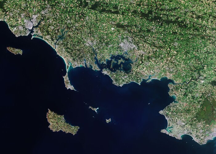
The Copernicus Sentinel-2 mission takes us over Morbihan – a French department in the south of Brittany.
Earth from Space: Morbihan, France
7.5.2021 10:00 ESA Observing the Earth
The Copernicus Sentinel-2 mission takes us over Morbihan – a French department in the south of Brittany.
Data Enrichment – obohacení vašich dat
7.5.2021 9:24 blog ARCDATA Data Enrichment (tzv. obohacení dat) propojí vaše prostorová data s demografickými a socio-ekonomickými statistikami, které jsou dostupné ve 137 zemích světa. Můžete tak dostat odpovědi na otázky: Kolik lidí zde žije? Jak jsou staří? Jaký je jejich životní styl? Za co nejvíce utrácejí?RoadBotics Introduces AgileMapper, a New Asset Mapping Platform
7.5.2021 9:00 GISCafe.com Webcasts-Webinars PITTSBURGH, PA, May 6, 2021 - RoadBotics is excited to announce the release of their new AgileMapper platform to its suite of products that helps …Autodesk Extends Invitation to Join Financial Results Conference Call
7.5.2021 9:00 GISCafe.com Webcasts-Webinars First Quarter Fiscal 2022 Financial Results Conference Call to be Held Thursday, May 27, 2021, 2:00 p.m. PTSAN FRANCISCO, May 3, 2021 — …
Ouster Hires Go-to-Market Leader to Accelerate Lidar Adoption Across Verticals
7.5.2021 2:05 GISCafe.com Webcasts-Webinars Nathan Dickerman joins as President of Field OperationsSAN FRANCISCO — (BUSINESS WIRE) — May 6, 2021 —
Ouster, Inc. (NYSE: OUST), …
Ouster Reports Record First Quarter 2021 Results
7.5.2021 2:05 GISCafe.com Webcasts-Webinars Record revenue of $6.6 million, up 187% over the first quarter of 2020Record shipments of 978 sensors, up 240% over the first quarter of 2020
40 …
SPÚ umí čerpat z fondů EU
7.5.2021 0:00 Státní pozemkový úřad Praha, 7. května 2021 – Státní pozemkový úřad (SPÚ) čerpá finanční prostředky na pozemkové úpravy rovněž ze zdrojů EU. V největší míře financování projektů ze zdrojů EU probíhá z PROGRAMU ROZVOJE VENKOVA (PRV).SPÚ umí čerpat z fondů EU
7.5.2021 0:00 Státní pozemkový úřad Praha, 7. května 2021 – Státní pozemkový úřad (SPÚ) čerpá finanční prostředky na pozemkové úpravy rovněž ze zdrojů EU. V největší míře financování projektů ze zdrojů EU probíhá z PROGRAMU ROZVOJE VENKOVA (PRV).ISKN Import pro nahrání dat katastru do ArcGISu
6.5.2021 21:38 GeoBusinessPokud používáte software ArcGIS od Esri, mohl by se vám v souvislosti s používáním katastrálních dat hodit nástroj ISKN Import od firmy Arcdata Praha. Nový software doplňuje či nahrazuje ISKN Studio, které se používalo v programu ArcMap. Český úřad zeměměřický a katastrální, který katastr nemovitostí spravuje, publikuje data katastru také prostřednictvím souborů ve formátu VFK […]
The post ISKN Import pro nahrání dat katastru do ArcGISu appeared first on GeoBusiness.
ISKN Import pro nahrání katastrálních dat do ArcGISu
6.5.2021 21:38 GeoBusinessPokud používáte software ArcGIS od Esri, mohl by se vám v souvislosti s používáním katastrálních dat hodit nástroj ISKN Import od firmy Arcdata Praha. Nový software doplňuje či nahrazuje ISKN Studio, které se používalo v programu ArcMap. Český úřad zeměměřický a katastrální, který katastr nemovitostí spravuje, publikuje data katastru také prostřednictvím souborů ve formátu VFK […]
The post ISKN Import pro nahrání katastrálních dat do ArcGISu appeared first on GeoBusiness.
BlackSky Demonstrates Growth and Scalability with Planned Launch of Additional Satellites
6.5.2021 17:10 GISCafe.com Webcasts-Webinars Company Continues Constellation Expansion to Increase Capacity for First-to-Know InsightsHERNDON, Va. — (BUSINESS WIRE) — May 6, 2021 …
Robotic Research Announced as Finalist for AUVSI XCELLENCE Awards
6.5.2021 17:10 GISCafe.com Webcasts-Webinars Company’s transformable Pegasus Mini hybrid drone-ground robot nominated for Innovation categoryCLARKSBURG, Md. — (BUSINESS WIRE) — …
Outsight Introduces the First LiDAR Pre-processing Software Engine
6.5.2021 17:10 GISCafe.com Webcasts-Webinars The easiest way to use LiDAR LiDAR technology is a strong emerging trend in the Computer Vision landscape: over $3 billion have been invested …
Oznámení o změně rozsahu úředních hodin
6.5.2021 16:01 ČÚZK /Urady/Katastralni-urady/Katastralni-urady/Katastralni-urad-pro-Jihocesky-kraj/O-uradu/Aktuality/Oznameni-o-zmene-rozsahu-urednich-hodinOznámení o změně rozsahu úředních hodin
6.5.2021 16:01 ČÚZK - předpisy a opatření Katastrální úřad pro Jihočeský kraj zveřejnil novou aktualitu: S účinností ode dne 31.5.2021 dochází ke změně rozsahu úředních hodin všech katastrálních pracovišť Katastrálního úřadu pro Jihočeský kraj:pondělí a středa 8 – 17 hodin
úterý a čtvrtek 8 – 14 hodin
pátek 8 – 12 hodin
Podrobnější informace naleznete zde.
Novinky ke světové konferenci Esri 2021
6.5.2021 15:49 ARCDATAI v letošním roce se bude největší světové setkání geoinformatiků, uživatelská konference Esri, konat virtuální formou a již nyní se můžeme seznámit s předběžným programem a jeho styčnými tématy.
Čeká nás více než 500 přednášek a technologických workshopů. Navštívit tak můžeme například workshopy:
- ArcGIS Pro: Tipy a triky – podíváme se na celou řadu užitečných funkcí a nástrojů, které jsou dostupné v prostředí ArcGIS Pro.
- ArcGIS Field Apps: Q&A – v této sekci bude možnost živě se ptát a diskutovat s týmem vyvíjejícím aplikace do terénu.
- ArcGIS Image for ArcGIS Online: Introduction – seznámení s novými možnostmi správy, vizualizace a analýzy snímků na ArcGIS Online.
Více se o chystaných workshopech dočtete na stránkách Esri.

Nezapomeňte se na světovou konferenci Esri zaregistrovat na stránkách konference. Pro všechny uživatele z organizací, které mají platnou systémovou podporu (maintenance) či aktivní placený plán, je registrace na konferenci zdarma. Vedle toho mají svoji účast na konferenci zdarma i studenti a čerství absolventi vysokých škol.
20210506 - VŘ Řízení a koordinace HD
6.5.2021 15:32 ČÚZK - aktuality v resortu Oznámení o vyhlášení výběrového řízení na obsazení služebního místa rada/odborný rada - Řízení a koordinace helpdesku.20210506 - VŘ Řízení a koordinace HD
6.5.2021 15:32 ČÚZK /Aktuality-resort/2021/20210506-VR-Rizeni-a-koordinace-HD20210506 - VŘ Řízení a koordinace HD
6.5.2021 15:32 ČÚZK - předpisy a opatření Český úřad zeměměřický a katastrální zveřejnil novou aktualitu: Oznámení o vyhlášení výběrového řízení na obsazení služebního místa rada/odborný rada - Řízení a koordinace helpdesku.Rada/odborný rada - Řízení a koordinace helpdesku
6.5.2021 15:21 ČÚZK - předpisy a opatření Český úřad zeměměřický a katastrálnívypisuje výběrové řízení na místo
Rada/odborný rada - Řízení a koordinace helpdesku