


zprávy
zdroje zpráv:VertiGIS, AED-SICAD Wins Open Grid Europe Contract
10.1.2020 11:23 GISCafe.com Webcasts-Webinars Solution to merge different data in SAP HANA(Munich), 9 January 2020 - Open Grid Europe (OGE) is one of the leading gas transporters in Europe with …
Introducing the Mesa® 3 Rugged Tablet by Juniper Systems, Now Shipping
10.1.2020 11:05 GISCafe.com Webcasts-Webinars 01/09/20 -- Logan, UT -- Juniper Systems, Inc. is excited to announce the release of the Mesa 3 Rugged Tablet. Built on the success of …vrchní referent/rada – vedení katastrální mapy
10.1.2020 11:02 ČÚZK - předpisy a opatření Katastrální úřad pro Olomoucký kraj - Katastrální pracoviště Jeseníkvypisuje výběrové řízení na místo
vrchní referent/rada – vedení katastrální mapy
vrchní referent/rada – vedení katastrální mapy
10.1.2020 11:02 ČÚZK /Urady/Katastralni-urady/Katastralni-urady/Katastralni-urad-pro-Olomoucky-kraj/Uredni-deska/Oznameni-a-jina-uredni-sdeleni/Volna-mista/DMS/VR-KP-JESENIK-vrchni-referent-rada-–-vedeni-katavrchní referent/rada – vedení katastrální mapy
10.1.2020 11:02 ČÚZK - volná místa Katastrální úřad pro Olomoucký kraj - Katastrální pracoviště Jeseník vypisuje výběrové řízení na místo vrchní referent/rada – vedení katastrální mapyVŘ KP JESENÍK - vrchní referent/rada – vedení katastrální mapy
10.1.2020 11:02 ČÚZK - předpisy a opatření Katastrální úřad pro Olomoucký kraj Katastrální pracoviště Jeseníkvypisuje výběrové řízení na místo
VŘ KP JESENÍK - vrchní referent/rada – vedení katastrální mapy
Mine communication systems and drones key investment priorities for miners, says GlobalData
10.1.2020 10:13 GISCafe.com Webcasts-Webinars 9th January 2020 -- The drive to improve productivity, efficiency and safety is leading to rising investment by mining companies, large and …Faroe Islands
10.1.2020 10:00 ESA Observing the Earth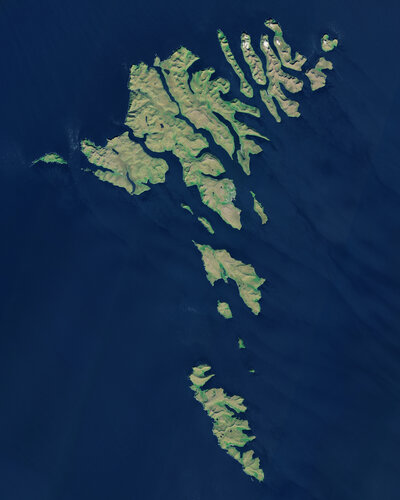 Image:
The Copernicus Sentinel-2 mission takes us over the Faroe Islands, located halfway between Iceland and Norway in the North Atlantic Ocean. The Faroe Islands are an archipelago made up of 18 jagged islands and are a self-governing nation under the external sovereignty of the Kingdom of Denmark.
The archipelago is around 80 km wide and has a total area of approximately 1400 sq km. The official language of the Faroe Islands is Faroese, a Nordic language which derives from the language of the Norsemen who settled the islands over 1000 years ago.
The islands have a population of around 50 000 inhabitants – as well as 70 000 sheep. Around 40% of the population reside in the capital and largest city of the Faroe Islands, Tórshavn, visible on the island of Streymoy, slightly above the centre of the image.
The islands are a popular destination for birdwatchers, particularly on the island of Mykines, the westernmost island of the Faroese Archipelago. The island provides a breeding and feeding habitat for thousands of birds, including the Atlantic Puffins.
Several inland water bodies can be seen dotted around the islands. Lake Sørvágsvatn, the largest lake of the Faroe Islands, is visible at the bottom of Vágar Island to the right of Mykines. Vágar Airport, the only airport in the Faroe Islands, can be seen left of the lake.
In this image, captured on 21 June 2018, several clouds can be seen over the Northern Isles, top right of the image. Low vegetation is visible in bright green.
The unique landscape of the Faroe Islands was shaped by volcanic activity approximately 50 to 60 million years ago. The original plateau was later restructured by the glaciers of the ice age and the landscape eroded into an archipelago characterised by steep cliffs, deep valleys and narrow fjords.
The official language of the Faroe Islands is Faroese, a Nordic language which derives from the language of the Norsemen who settled the islands over 1000 years ago.
The islands are particularly known for their dramatic landscape, grass-roofed houses and treeless moorlands. The Faroe Islands boast over 1000 km of coastline and because of their elongated shape, one can never be more than five km to the ocean from any point of the islands.
This image is also featured on the Earth from Space video programme.
Earth from Space: Faroe Islands
10.1.2020 10:00 ESA Observing the Earth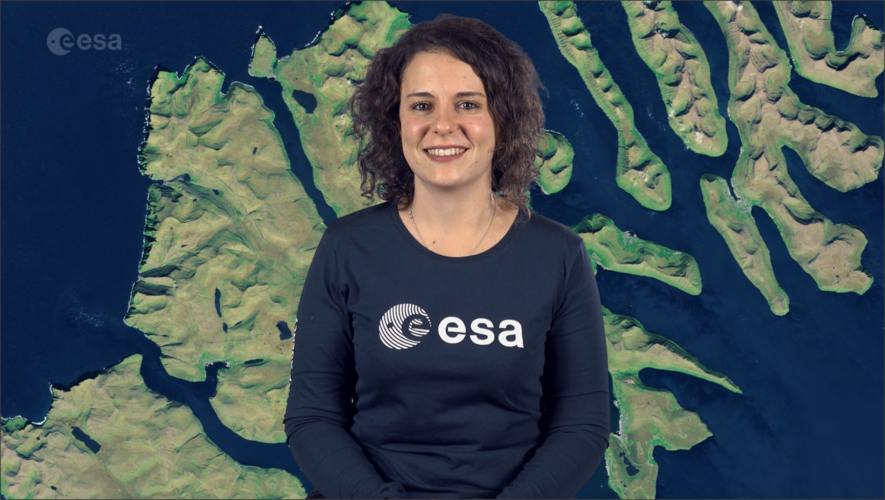 Video:
00:02:37
Video:
00:02:37
This week's edition of the Earth from Space programme features a Copernicus Sentinel-2 image over the Faroe Islands – located halfway between Iceland and Norway in the North Atlantic Ocean.
See also Faroe Islands to download the image.
Faroe Islands
10.1.2020 10:00 ESA Observing the Earth
Image:
The Copernicus Sentinel-2 mission takes us over the Faroe Islands, located halfway between Iceland and Norway in the North Atlantic Ocean. The Faroe Islands are an archipelago made up of 18 jagged islands and are a self-governing nation under the external sovereignty of the Kingdom of Denmark.
The archipelago is around 80 km wide and has a total area of approximately 1400 sq km. The official language of the Faroe Islands is Faroese, a Nordic language which derives from the language of the Norsemen who settled the islands over 1000 years ago.
The islands have a population of around 50 000 inhabitants – as well as 70 000 sheep. Around 40% of the population reside in the capital and largest city of the Faroe Islands, Tórshavn, visible on the island of Streymoy, slightly above the centre of the image.
The islands are a popular destination for birdwatchers, particularly on the island of Mykines, the westernmost island of the Faroese Archipelago. The island provides a breeding and feeding habitat for thousands of birds, including the Atlantic Puffins.
Several inland water bodies can be seen dotted around the islands. Lake Sørvágsvatn, the largest lake of the Faroe Islands, is visible at the bottom of Vágar Island to the right of Mykines. Vágar Airport, the only airport in the Faroe Islands, can be seen left of the lake.
In this image, captured on 21 June 2018, several clouds can be seen over the Northern Isles, top right of the image. Low vegetation is visible in bright green.
The unique landscape of the Faroe Islands was shaped by volcanic activity approximately 50 to 60 million years ago. The original plateau was later restructured by the glaciers of the ice age and the landscape eroded into an archipelago characterised by steep cliffs, deep valleys and narrow fjords.
The islands are particularly known for their dramatic landscape, grass-roofed houses and treeless moorlands. The Faroe Islands boast over 1000 km of coastline and because of their elongated shape, one can never be more than five km to the ocean from any point of the islands.
This image is also featured on the Earth from Space video programme.
OGC announces the creation of new Environmental Data Retrieval API Standards Working Group
10.1.2020 9:56 GISCafe.com Webcasts-Webinars The new Working Group will create stable, standardized, service APIs based on simple data retrieval patterns, which will improve access to …GSA Executive Director receives Karel Kramar distinction
10.1.2020 9:46 European GNSS Agency
The European GNSS Agency (GSA) Executive Director has been awarded the Karel Kramar Medal by the Czech Prime Minister. The honour is awarded as a token of gratitude for demonstrable service in the Czech Republic.
The honour was awarded to the GSA Executive Director, Carlo des Dorides in a ceremony held at on January 8 at the Office of the Government of the Czech Republic. In a tweet following the award ceremony, the Czech Prime Minister said: “I awarded the Karel Kramar honour to the GSA Director Mr Carlo des Dorides, who was responsible for moving the Galileo navigation system to Prague in 2012.”
“Space systems have huge potential and the GSA headquarters in the Czech Republic offers many opportunities for our entrepreneurs,” the Prime Minister Andrej Babis said.
Great honour
Accepting the award, des Dorides thanked the Prime Minister for the great honour bestowed on him and outlined the history of the GSA in the Czech Capital. “When the GSA came to Prague on September 2012 it was a small agency with many plans and hopes and Galileo was a system on paper only,” he said.

Read this: A message from Carlo des Dorides, GSA Executive Director
“We can now safely say that a lot has changed in these 7 years. The GSA has grown to more than 5 times its original size and is now sitting at the table with the main space agencies in Europe; 26 satellites have been launched and Galileo is operational with more than 1 billion users world-wide,” des Dorides said.
Space renaissance
In his speech, the GSA Executive Director also looked to the future and the evolution of the GSA into the European Union Agency for the Space Programme (EUSPA). “The Czech Republic is now positioning itself, more and more, at the centre of a ‘space renaissance’ with high potential ahead,” he said.
And this: From GSA to EUSPA: space transforming business and the economy
“My best wish is that EUSPA will be for the Czech Republic not only a nice jewel but will really become the engine of a new course for the Czech entrepreneurial sector, which uses space as a driver for innovation,” he said, adding: “When I look at the number of new companies belonging to the space ecosystem that are looking at establishing here in the Czech Republic, I think you have already started to move in this direction.”
The Karel Kramar Honour was crafted to mark the 90th anniversary of the establishment of the first Czechoslovak government and was named after the first Czechoslovak Prime Minister, Karel Kramar.
Media note: This feature can be republished without charge provided the European GNSS Agency (GSA) is acknowledged as the source at the top or the bottom of the story. You must request permission before you use any of the photographs on the site. If you republish, we would be grateful if you could link back to the GSA website (http://www.gsa.europa.eu).
GSA Executive Director receives Karel Kramar distinction
10.1.2020 9:46 European GNSS AgencyThe European GNSS Agency (GSA) Executive Director has been awarded the Karel Kramar Medal by the Czech Prime Minister. The honour is awarded as a token of gratitude for demonstrable service in the Czech Republic.
The honour was awarded to the GSA Executive Director, Carlo des Dorides in a ceremony held at on January 8 at the Office of the Government of the Czech Republic. In a tweet following the award ceremony, the Czech Prime Minister said: “I awarded the Karel Kramar honour to the GSA Director Mr Carlo des Dorides, who was responsible for moving the Galileo navigation system to Prague in 2012.”
“Space systems have huge potential and the GSA headquarters in the Czech Republic offers many opportunities for our entrepreneurs,” the Prime Minister Andrej Babis said.
Great honour
Accepting the award, des Dorides thanked the Prime Minister for the great honour bestowed on him and outlined the history of the GSA in the Czech Capital. “When the GSA came to Prague on September 2012 it was a small agency with many plans and hopes and Galileo was a system on paper only,” he said.
Read this: A message from Carlo des Dorides, GSA Executive Director
“We can now safely say that a lot has changed in these 7 years. The GSA has grown to more than 5 times its original size and is now sitting at the table with the main space agencies in Europe; 26 satellites have been launched and Galileo is operational with more than 1 billion users world-wide,” des Dorides said.
Space renaissance
In his speech, the GSA Executive Director also looked to the future and the evolution of the GSA into the European Union Agency for the Space Programme (EUSPA). “The Czech Republic is now positioning itself, more and more, at the centre of a ‘space renaissance’ with high potential ahead,” he said.
And this: From GSA to EUSPA: space transforming business and the economy
“My best wish is that EUSPA will be for the Czech Republic not only a nice jewel but will really become the engine of a new course for the Czech entrepreneurial sector, which uses space as a driver for innovation,” he said, adding: “When I look at the number of new companies belonging to the space ecosystem that are looking at establishing here in the Czech Republic, I think you have already started to move in this direction.”
The Karel Kramar Honour was crafted to mark the 90th anniversary of the establishment of the first Czechoslovak government and was named after the first Czechoslovak Prime Minister, Karel Kramar.
Media note: This feature can be republished without charge provided the European GNSS Agency (GSA) is acknowledged as the source at the top or the bottom of the story. You must request permission before you use any of the photographs on the site. If you republish, we would be grateful if you could link back to the GSA website (http://www.gsa.europa.eu).
Pozvánka na přednášku Matematika, fyzika a astronomie 16.-18. století ve fondu Národní knihovny [Knihovna geografie, byTopic]
10.1.2020 9:35 Katedra aplikované geoinformatiky a kartografie Přf UK Přednáška se uskuteční v úterý 4. února 2020 od 17:00 v zasedací místnosti Klementina v prvním patře. Vstup je zdarma.Aeolus winds now in daily weather forecasts
10.1.2020 9:00 ESA Observing the Earth
ESA’s Aeolus satellite has been returning profiles of Earth’s winds since 3 September 2018, just after it was launched – and after months of careful testing these measurements are considered so good that the European Centre for Medium-Range Weather Forecasts is now using them in their forecasts.
Dotazník: uživatelské požadavky na nový Národní geoportál
10.1.2020 7:00 Česká asociace pro geoinformaceDotazník: uživatelské požadavky na nový Národní geoportál
Současný geoportál INSPIRE, který je v provozu již od roku 2011, je nutné obnovit. CENIA, která zpracovává studii proveditelnosti, připravila dotazník pro sběr uživatelských požadavků. Jeho vyplnění nezabere více než 10 minut. Dotazník je určen především pro akademické pracovníky a
Chystají se 55. Geodetické informační dny
10.1.2020 6:42 ZeměměřičSpolek zeměměřičů Brno oznámil termín své každoroční akce. 55. Geodetické informační dny se letos budou konat ve dnech 3. a 4. března 2020 v Brně (hotel Avanti, Střední 61, Brno). Na více informací v tuto chvíli čekáme, až budou uveřejněny.
The post Chystají se 55. Geodetické informační dny appeared first on Zeměměřič.
Montana Signs Participating Addendum with Avion Unmanned to Provide Drone Services to Public Agencies
10.1.2020 1:01 GISCafe.com Webcasts-Webinars HUNTSVILLE, Ala., Jan. 9, 2020 — (PRNewswire) — Avion Unmanned, the Unmanned Aircraft Systems (UAS) division of Avion Solutions, …INSPIRE téma Rozšířené Parcely (CPX)
10.1.2020 1:00 Cenia - Katalog metadat ČR - INSPIRE Rozšíření má za cíl poskytovat katastrální mapu s obsahem podle vyhlášky ve vektorové podobě ve struktuře plně v souladu se strukturou danou směrnicí INSPIRE. Data rozšiřují směrnici INSPIRE pro téma katastrální parcely (CP) o věcná břemena, geodetické body, další prvky mapy, původní obloukovou geometrii a o parcely určené definičním bodem (ty pouze v oblastech s analogovou mapou). Vychází z katastrální mapy, která je závazným státním mapovým dílem velkého měřítka, obsahuje body polohového bodového pole, polohopis a popis a může mít formu digitální mapy, analogové mapy nebo digitalizované mapy. Publikovaná data obsahují katastrální území pro celou Českou Republiku, parcely a jejich hranice, věcná břemena, další prvky mapy a původní obloukovou geometrii z území, kde je digitální mapa (k 06. 01. 2020 je to 96,69% území České republiky, t.j. 76 253,73km2) a ve zbytku území katastrální parcely určené pouze definičním bodem (tedy bez hranic a polygonu). Katastrální parcely a hranice obsahují oproti datové sadě INSPIRE některé atributy navíc. Jedná se o typ hranice, způsob využití území, druh pozemku, vazbu na budovu a o mapové značky. Více katastrální zákon 344/1992 SB., katastrální vyhláška č.26/2007 Sb. v platném znění a INSPIRE Data Specification on Cadastral Parcels v 3.0.1. Data ve formátu GML 3.2.1 jsou validní proti schématu XML pro Rozšířené Parcely (CPX) ve verzi 4.0.Aquiline Drones Ascends to New Heights as Fastest-Growing, Full-Service Drone Company in the USA
9.1.2020 19:11 GISCafe.com Webcasts-Webinars A group of airline pilots have created the first U.S.-based, drone-dedicated technology and manufacturing company that provides real-time data …Trimble to Acquire Kuebix to Transform and Connect the Transportation Logistics Ecosystem
9.1.2020 19:10 GISCafe.com Webcasts-Webinars Combined Cloud Platform to Create the Largest Connected Network of Shippers and Carriers in the North American Supply Chain, Improving Resource …Esri Collaborates with IAAO to Bring New Location Intelligence Capabilities to Property Assessors
9.1.2020 19:10 GISCafe.com Webcasts-Webinars Program Gets New Members Started with GIS for Spatial Analysis, Visualization, and Data SharingREDLANDS, Calif. — (BUSINESS WIRE) — …
Environics Analytics and Snowflake Empower Canadian Tourism Industry with Faster and Better Data-Driven Insights
9.1.2020 19:10 GISCafe.com Webcasts-Webinars VisitorView Helps Tourism Organizations Better Understand Visitors and Maximize Marketing Budget EfficiencySAN MATEO, Calif. — (BUSINESS WIRE) …
Swift Tactical Systems Lands $17M National Drone and Services Contract
9.1.2020 19:10 GISCafe.com Webcasts-Webinars The Program Will Support Bahamas Ministry of National Security, Law Enforcement, Immigration and CustomsSAN CLEMENTE, Calif., Jan. 9, 2020 — …
Esri Releases Update of Ready-to-Use US Census Bureau Data in ArcGIS Living Atlas of the World
9.1.2020 19:10 GISCafe.com Webcasts-Webinars New American Community Survey Data Will Be Available for Instant Access by ArcGIS UsersREDLANDS, Calif. — (BUSINESS WIRE) — January 9, …
Draganfly Inc. Announces OTCQB Listing and DTC Eligibility
9.1.2020 19:10 GISCafe.com Webcasts-Webinars Vancouver, British Columbia, Jan. 09, 2020 (GLOBE NEWSWIRE) -- Draganfly Inc. (CSE: DFLY) (OTCQB: DFLYF) (FSE: 3U8) (“Draganfly” or the …Montana Signs Participating Addendum with DroneUp Providing Public Sector Agencies Access to Drone Services
9.1.2020 19:10 GISCafe.com Webcasts-Webinars VIRGINIA BEACH, Va., Jan. 9, 2020 — (PRNewswire) — DroneUp, LLC and the State of Montana have signed a Participating Addendum for …SOS LAB Signs a LiDAR Collaboration MOU with ON Semiconductor to Advance the Development and Commercialization of Solid-state LiDAR for Automotive and Smart Factory Markets
9.1.2020 19:10 GISCafe.com Webcasts-Webinars GWANGJU, South Korea & LAS VEGAS — (BUSINESS WIRE) — January 9, 2020 —SOS LAB, a LiDAR startup for self-driving cars, and ON …
Pointfuse Software Powers Design of Formula One E-Racer Plane
9.1.2020 19:09 GISCafe.com Webcasts-Webinars January 09, 2020 -- Pointfuse is helping engineers design and develop an electric plane that will take part in the Air Race E competition later this …Pozemkové úpravy a obvyklá výška nájomného
9.1.2020 16:44 Komora pozemkových úprav SR
Na základe údajov MPRV SR o obvyklej výške nájomného možno posudzovať vplyv ukončených PÚ na výšku nájomného
Pozemkové úpravy a obvyklá výška nájomného
9.1.2020 16:44 Komora pozemkových úprav SRNa základe údajov MPRV SR o obvyklej výške nájomného možno posudzovať vplyv ukončených PÚ na výšku nájmu![]() ovn_a0_sr.pdf...
ovn_a0_sr.pdf...
Aerosol spread from Australian fires
9.1.2020 16:00 ESA Observing the Earth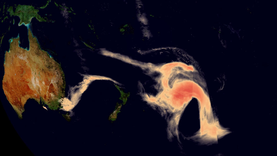 Video:
00:00:20
Video:
00:00:20
Ferocious bushfires have been sweeping across Australia since September, fuelled by record-breaking temperatures, drought and wind. The country has always experienced fires, but this season has been horrific. A staggering 10 million hectares of land have been burned, at least 24 people have been killed and it has been reported that almost half a billion animals have perished. The fires have not only decimated the land, but they have also had a serious effect on air quality.
The Copernicus Sentinel-5 Precursor mission is dedicated to monitoring air pollution by measuring a multitude of trace gases as well as aerosols – all of which affect the air we breathe. This animation shows the immense spread of aerosols from bushfires in southeast Australia between 28 December 2019 and 8 January 2020. These plumes of particles have swept over New Zealand and crossed the South Pacific Ocean, even reaching Chile and Argentina.
Aerosol spread from Australian fires
9.1.2020 16:00 ESA Observing the Earth
Video:
00:00:20
Ferocious bushfires have been sweeping across Australia since September, fuelled by record-breaking temperatures, drought and wind. The country has always experienced fires, but this season has been horrific. A staggering 10 million hectares of land have been burned, at least 24 people have been killed and it has been reported that almost half a billion animals have perished. The fires have not only decimated the land, but they have also had a serious effect on air quality.
The Copernicus Sentinel-5 Precursor mission is dedicated to monitoring air pollution by measuring a multitude of trace gases as well as aerosols – all of which affect the air we breathe. This animation shows the immense spread of aerosols from bushfires in southeast Australia between 28 December 2018 and 8 January 2020. These plumes of particles have swept over New Zealand and crossed the South Pacific Ocean, even reaching Chile and Argentina.
CubeSat finds its way in space with Galileo receiver
9.1.2020 15:58 ESA Navigation
A miniature CubeSat has become the first satellite to perform Galileo-based position fixes in orbit using a commercial satnav receiver.
16. ze 126 pražských škol: Pražská zeměměřická průmyslovka oceněna
9.1.2020 15:23 ZeměměřičNa StředníRoku.cz mohou studenti i absolventi středních škol prostřednictvím sociální sítě Facebook přidělením hvězdiček ohodnotit svoji školu. Výsledné žebříčky pro jednotlivé kraje jsou pak k dispozici po jednotlivých školních rocích na www.stredniroku.cz/zebricky Aby mezi sebou mohly soupeřit školy s různou velikostí (s různým počtem studentů), přepočítávají se hvězdičky na procenta. Ta udávají výsledek hlasování a umístění školy ve výsledném žebříčku. Školy […]
The post 16. ze 126 pražských škol: Pražská zeměměřická průmyslovka oceněna appeared first on Zeměměřič.
Oznámení o vyhlášení výběrového řízení
9.1.2020 14:47 ČÚZK - předpisy a opatření Katastrální úřad pro Královéhradecký kraj - Katastrální pracoviště Trutnov zveřejnil novou aktualitu: Oznámení o vyhlášení výběrového řízení na služební místo rada / odborný rada v oddělení právních vztahů k nemovitostem Katastrálního pracoviště TrutnovOznámení o vyhlášení výběrového řízení
9.1.2020 14:47 ČÚZK /Urady/Katastralni-urady/Katastralni-urady/Katastralni-urad-pro-Kralovehradecky-kraj/O-uradu/Aktuality/Oznameni-o-vyhlaseni-vyberoveho-rizeni-(1)Oznámení o vyhlášení výběrového řízení
9.1.2020 14:45 ČÚZK /Urady/Katastralni-urady/Katastralni-urady/Katastralni-urad-pro-Kralovehradecky-kraj/Katastralni-pracoviste/KP-Trutnov/O-uradu/Aktuality/Oznameni-o-vyhlaseni-vyberoveho-rizeniOznámení o vyhlášení výběrového řízení
9.1.2020 14:45 ČÚZK - předpisy a opatření Katastrální úřad pro Královéhradecký kraj - Katastrální pracoviště Trutnov zveřejnil novou aktualitu: Oznámení o vyhlášení výběrového řízení na služební místo rada / odborný rada v oddělení právních vztahů k nemovitostem Katastrálního pracoviště TrutnovRozpočet úřadu za rok 2020
9.1.2020 14:39 ČÚZK - předpisy a opatření Katastrální úřad pro hlavní město Prahuvystavuje rozpočet úřadu za rok 2020
2020
Rozpočet úřadu za rok 2020
9.1.2020 14:39 ČÚZK /Urady/Katastralni-urady/Katastralni-urady/Katastralni-urad-pro-hlavni-mesto-Prahu/Rozpocet/Rozpocet-uradu-za-rok-2020Odborný referent v právním oddělení č.2 na Katastrálním pracovišti Brno - město
9.1.2020 14:21 ČÚZK - volná místa Katastrální úřad pro Jihomoravský kraj Katastrální pracoviště Brno-město vypisuje výběrové řízení na místo Odborný referent v právním oddělení č.2 na Katastrálním pracovišti Brno - městoOdborný referent v právním oddělení č.2 na Katastrálním pracovišti Brno - město
9.1.2020 14:21 ČÚZK /Urady/Katastralni-urady/Katastralni-urady/Katastralni-urad-pro-Jihomoravsky-kraj/Volna-mista/DMS/Odborny-referent-v-pravnim-oddeleni-c-2-na-Kat-(1)Odborný referent v právním oddělení č.2 na Katastrálním pracovišti Brno - město
9.1.2020 14:21 ČÚZK - předpisy a opatření Katastrální úřad pro Jihomoravský kraj Katastrální pracoviště Brno-městovypisuje výběrové řízení na místo
Odborný referent v právním oddělení č.2 na Katastrálním pracovišti Brno - město
Odborný referent v právním oddělení č.2 na Katastrálním pracovišti Brno - město
9.1.2020 14:16 ČÚZK /Urady/Katastralni-urady/Katastralni-urady/Katastralni-urad-pro-Jihomoravsky-kraj/Volna-mista/DMS/Odborny-referent-v-pravnim-oddeleni-c-2-na-KatastrOdborný referent v právním oddělení č.2 na Katastrálním pracovišti Brno - město
9.1.2020 14:16 ČÚZK - volná místa Katastrální úřad pro Jihomoravský kraj Katastrální pracoviště Brno-město vypisuje výběrové řízení na místo Odborný referent v právním oddělení č.2 na Katastrálním pracovišti Brno - městoOdborný referent v právním oddělení č.2 na Katastrálním pracovišti Brno - město
9.1.2020 14:16 ČÚZK - předpisy a opatření Katastrální úřad pro Jihomoravský kraj Katastrální pracoviště Brno-městovypisuje výběrové řízení na místo
Odborný referent v právním oddělení č.2 na Katastrálním pracovišti Brno - město
Australia: like a furnace
9.1.2020 13:59 ESA Observing the Earth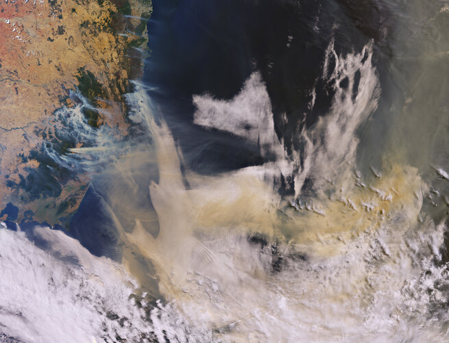
Ferocious bushfires have been sweeping across Australia since September, fuelled by record-breaking temperatures, drought and wind. The country has always experienced fires, but this season has been horrific. A staggering 10 million hectares of land have been burned, at least 24 people have been killed and it has been reported that almost half a billion animals have perished.
Škoda Octavia combi, RZ 4B0 5784
9.1.2020 13:58 ČÚZK - předpisy a opatřeníKatastrální úřad pro Jihomoravský kraj nabízí nepotřebný majetek k odkupu. Jedná se o
Škoda Octavia combi, RZ 4B0 5784
Škoda Octavia combi, RZ 4B0 5784
9.1.2020 13:58 ČÚZK /Urady/Katastralni-urady/Katastralni-urady/Katastralni-urad-pro-Jihomoravsky-kraj/Nabidky-majetku/Skoda-Octavia-combi,-RZ-4B0-5784Škoda Octavia, RZ BZO 85-07
9.1.2020 13:05 ČÚZK /Urady/Katastralni-urady/Katastralni-urady/Katastralni-urad-pro-Jihomoravsky-kraj/Nabidky-majetku/Skoda-Octavia,-RZ-BZO-85-07Škoda Octavia, RZ BZO 85-07
9.1.2020 13:05 ČÚZK - předpisy a opatřeníKatastrální úřad pro Jihomoravský kraj nabízí nepotřebný majetek k odkupu. Jedná se o
Škoda Octavia, RZ BZO 85-07
Rozpočet úřadu za rok 2020
9.1.2020 12:41 ČÚZK /Urady/Katastralni-urady/Katastralni-urady/Katastralni-urad-pro-Zlinsky-kraj/Rozpocet/Rozpocet-uradu-za-rok-2020Rozpočet úřadu za rok 2020
9.1.2020 12:41 ČÚZK - předpisy a opatření Katastrální úřad pro Zlínský krajvystavuje rozpočet úřadu za rok
2020
Rozpočet úřadu za rok 2020
9.1.2020 10:10 ČÚZK - předpisy a opatření Zeměměřický a katastrální inspektorát v Prazevystavuje rozpočet úřadu za rok 2020
2020
Rozpočet úřadu za rok 2020
9.1.2020 10:10 ČÚZK /Urady/Zememericke-a-katastralni-inspektoraty/Zememericke-a-katastralni-inspektoraty/Zememericky-a-katastralni-inspektorat-v-Praze/Rozpocet/Rozpocet-uradu-za-rok-2020Výroční souhrnná resortní zpráva za rok 2019
9.1.2020 9:47 ČÚZK - předpisy a opatření Katastrální úřad pro Jihočeský krajvydává výroční zprávu úřadu za rok
2019
Přidejte své podněty k nové verzi geoportálu INSPIRE
9.1.2020 9:43 GeoBusiness Současný geoportál INSPIRE, který je v provozu již od roku 2011, je nutné obnovit. Víc hlav víc ví, proto redakci časopisu GeoBusiness Jitka Faugnerová z agentury CENIA, která Národní geoportál INSPIRE provozuje, požádala o zveřejnění prosby všem kolegům z oboru. Vážení kolegové, obracím se na Vás s prosbou o spolupráci při zjišťování uživatelských požadavků na nový […]Sběr podnětů a uživatelských požadavků pro nový geoportál INSPIRE
9.1.2020 8:43 GISportal.cz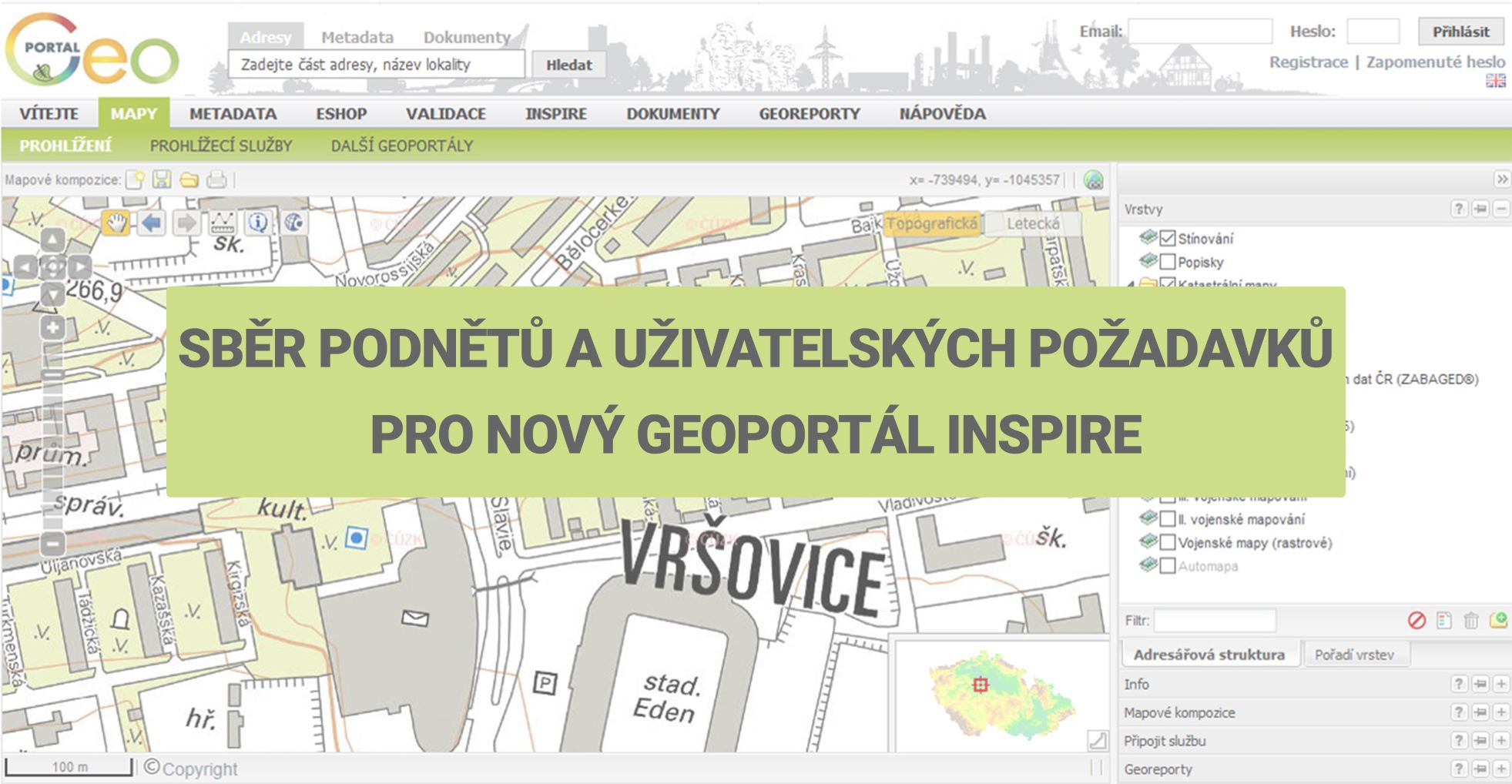
CENIA, česká informační agentura životního prostředí zahájila sběr uživatelských požadavků pro nový geoportál. Současný Národní geoportál INSPIRE, který CENIA provozuje již od roku 2011, čeká obnova. Pro nový geoportál sbíráme podněty a nápady a chceme znát Váš názor na stávající řešení. Chtěli bychom Vás proto požádat o vyplnění tohoto dotazníku do 31. ledna. Dotazník obsahuje […]
The post Sběr podnětů a uživatelských požadavků pro nový geoportál INSPIRE appeared first on GISportal.cz.
Výběrové řízení - Inspektor/ka – právník Zeměměřického a katastrálního inspektorátu v Praze
9.1.2020 6:25 ČÚZK /Urady/Zememericke-a-katastralni-inspektoraty/Zememericke-a-katastralni-inspektoraty/Zememericky-a-katastralni-inspektorat-v-Praze/O-uradu/Aktuality/Vyberove-rizeni-Inspektor-ka-–-pravnik-ZememericVýběrové řízení - Inspektor/ka – právník Zeměměřického a katastrálního inspektorátu v Praze
9.1.2020 6:25 ČÚZK - předpisy a opatření Zeměměřický a katastrální inspektorát v Praze zveřejnil novou aktualitu: Oznámení o vyhlášení výběrového řízení na obsazení služebního místa Inspektor/ka – právník Zeměměřického a katastrálního inspektorátu v Praze (obor služby 55.)INSPIRE téma Budovy (BU)
9.1.2020 1:00 Cenia - Katalog metadat ČR - INSPIRE Data odpovídají směrnici INSPIRE pro téma budovy (BU). Data pochází částečně z projektu RÚIAN (Registr územní identifikace, adres a nemovitostí), který je součástí základních registrů České Republiky a obsahuje informace o územní identifikaci, adresách a nemovitostech, a částečně z ISKN (Informační systém katastru nemovistostí). Zdrojem informací o budovách v ISKN je objekt Stavba, v RÚIAN je to Stavební objekt. Většina Staveb je zároveň Stavebními objekty, ale jsou případy, kdy tomu tak není. Kromě Budov datová sada obsahuje i části budov, které jsou pro potřeby INSPIRE vyjádřeny vchody z RÚIAN. Vchody obsahují informace o počtu podlaží, technickoekonomických atributech apod. Datová sada pokrývá celé území české republiky. V datové sadě není uvedeno 1,15%, t.j. 48500 budov (k 06. 01. 2020), protože neobsahují definiční bod ani polygon. Více v zákoně č. 111/2009 Sb., o základních registrech, ve vyhlášce č. 359/2011 Sb., o základním registru územní identifikace, adres a nemovitostí v platných zněních, v zákoně 256/2013 Sb., o katastru nemovitostí, v katastrální vyhlášce č. 357/2013 Sb. v platném znění a INSPIRE Data Specification on Buildings v 3.0 z 13.12.2013. Data ve formátu GML 3.2.1 jsou validní proti schématu XML pro INSPIRE téma Budovy ve verzi 4.0 a proti schématu pro prostorová data ELF ve verzi 1.0.Katastrální mapa v rastrové podobě poskytovaná v e-shopu
9.1.2020 1:00 Cenia - Katalog metadat ČR - INSPIRE Katastrální mapa v rastrové podobě je poskytována za úplatu a obsahuje analogovou mapu s kompletní kresbou. Analogová mapa pokrývá 3,10 % území České republiky, což je 2 443,52km2. Více katastrální vyhláška č.357/2013 Sb. v platném znění.Katastrální mapa ve formátech DGN a DXF poskytovaná v e-shopu
9.1.2020 1:00 Cenia - Katalog metadat ČR - INSPIRE Katastrální mapa je závazným státním mapovým dílem velkého měřítka, obsahuje body polohového bodového pole, polohopis a popis. Katastrální mapa ve vektorové podobě je poskytována zdarma ve formátu DGN a DXF a obsahuje prvky Digitální katastrální mapy (DKM) a Katastrální mapy digitalizované (KMD), tedy bodová pole, budovy, další prvky mapy, hranice parcel, katastrální hranice, parcely katastru nemovitostí, prvky orientační mapy a hranice věcného břemene. Z důvodu použití formátu DGN produkt neobsahuje značky na liniích a oblouky jsou nahrazeny lomenými čárami. Katastrální mapa ve vektorové podobě k 06. 01. 2020 pokrývá 96,69% území České republiky, t.j. 76 253,73km2. Více katastrální vyhláška č.357/2013 Sb. v platném znění.INSPIRE téma Adresy (AD)
9.1.2020 1:00 Cenia - Katalog metadat ČR - INSPIRE Data odpovídají směrnici INSPIRE pro téma adresy (AD). Vychází především z projektu RÚIAN (Registr územní identifikace, adres a nemovitostí), který je součástí základních registrů České Republiky a obsahuje informace o územní identifikaci, adresách a nemovitostech. Data publikovaná v rámci INSPIRE obsahují pouze adresní místa a jejich komponenty, kterými jsou stát, obec, část obce, městský obvod v Praze (MOP), městký obvod/městská část (MO/MČ), ulice a pošta a to na území celé České Republiky. Obsahují rozvněž geometrii, která určuje definiční bod adresního místa. V datové sadě nění uvedeno 1,26%, t.j. 36947 adresních míst (k 06. 01. 2020), protože neobsahují definiční bod, podle kterého by je bylo možné prostorově určit. Více v zákoně č. 111/2009 Sb., o základních registrech a ve vyhlášce č. 359/2011 Sb., o základním registru územní identifikace, adres a nemovitostí v platných zněních a INSPIRE Data Specification on Addresses v 3.0.1 z 26.4.2010. Data ve formátu GML 3.2.1 jsou validní proti schématu XML pro INSPIRE téma Adresy ve verzi 4.0 a proti schématu pro prostorová data ELF ve verzi 1.0.INSPIRE – Kvalita ovzduší – přehledy (data) na měřicích stanicích / All AQ data associated with AQ monitoring stations
9.1.2020 1:00 Cenia - Katalog metadat ČR - INSPIRE Koncentrace látek znečišťujících ovzduší, pro které jsou stanoveny imisní limity pro ochranu lidského zdraví, naměřené na stanicích Státní imisní sítě r18As – Přehled stanic s ročními průměrnými koncentracemi As, 2018r18BaP – Přehled stanic s ročními průměrnými koncentracemi benzo[a]pyrenu, 2018r18BZN – Přehled stanic s ročními průměrnými koncentracemi benzenu, 2018r18Cd – Přehled stanic s ročními průměrnými koncentracemi kadmia, 2018r18CO – Přehled stanic s hodnotami oxidu uhelnatého (max. denní 8hod. klouzavý průměr), 2018r18Ni – Přehled stanic s ročními průměrnými koncentracemi niklu, 2018r18NO2 – Přehled stanic s koncentracemi NO2 (roční průměrná koncentrace NO2_Yr a max. 19. denní koncentrace oxidu dusičitého NO2max19), 2018r18O3 – Přehled stanic s hodnotami přízemního ozonu (max. denní 8hod. klouzavý průměr, v průměru za 3 roky), 2018r18Pb – Přehled stanic s ročními průměrnými olova Pb, 2018r18PM10 – Přehled stanic s koncentracemi PM10 (roční průměrná koncentrace rp_limit a max. 36. denní koncentrací max36_limit), 2018r18PM25 – Přehled stanic s ročními průměrnými koncentracemi PM2,5, 2018r18SO2_day – Přehled stanic s koncentracemi SO2 (max. 25. hodinová koncentrace SO2max25_1 max. 4. denní koncentrace SO2 max4_24), 2018Koncentrace polutantů, pro které jsou stanoveny imisní limity pro ochranu ekosystémů a vegetace, naměřené na stanicích Státní imisní sítě r18AOT40 – Přehled stanic s hodnotami AOT40 (pětiletý průměr), 2014–2018r18NOx – Přehled stanic s ročními průměrnými koncentracemi NOx, 2018r18SO2_W – Přehled stanic s koncentracemi SO2 (zimní průměr SO2_W), 2018r18SO2_Yr – Přehled stanic s ročními průměrnými koncentracemi SO2, 2018INSPIRE – Pole koncentrací znečišťujících látek / Air quality model areas
9.1.2020 1:00 Cenia - Katalog metadat ČR - INSPIRE Koncentrace látek znečišťujících ovzduší v gridu 1x1 km, rok 2018 Imisní limity pro ochranu lidského zdravíSO2 – 4. nejvyšší 24hod. koncentrace SO2 [µg.m-3]PM10 – roční průměrná koncentrace [µg.m-3]PM10 – 36. nejvyšší průměrná 24hod. koncentrace [µg.m-3]PM2.5 – roční průměrná koncentrace [µg.m-3]NO2 – roční průměrná koncentrace [µg.m-3]O3 – 26. nejvyšší maximální denní 8hod. klouzavý průměr koncentrace v průměru za 3 roky, 2015–2017 [µg.m-3]As – roční průměrná koncentrace [ng.m-3]Cd – roční průměrná koncentrace [ng.m-3]Ni – roční průměrná koncentrace [ng.m-3]Pb – roční průměrná koncentrace [ng.m-3]Benzo[a]pyren – roční průměrná koncentrace [ng.m-3]Benzen – roční průměrná koncentrace [µg.m-3]Oblasti s překročením imisních limitů bez zahrnutí O3Oblasti s překročením imisních limitů se zahrnutím O3 Imisní limity pro ochranu ekosystémů a vegetaceO3 – hodnoty expozičního indexu AOT40, průměr za 5 let, 2014–2018 [µg.m-3]NOx – roční průměrná koncentrace [µg.m-3]SO2 – rok (roční průměr) a zimní období (zimní průměr) [µg.m-3]Legislativa (zákon 201/2012 Sb. v platném znění) vyžaduje, aby primárním zdrojem hodnocení byly výsledky stacionárních měření. Naměřené koncentrace mohou být při tvorbě map znečisťujících látek doplněny modelováním a indikativním měřením, aby výsledný odhad poskytoval dostatečné informace o prostorovém rozložení koncentrací znečišťujících látek v ovzduší.V ČR je využíván zejména Eulerovský chemický disperzní model CAMx, doplňkově též Gaussovský model SYMOS a evropský Eulerovský model EMEP. Dále jsou to v případě jednotlivých znečišťujících látek např. nadmořská výška či populační hustota.INSPIRE téma Parcely (CP)
9.1.2020 1:00 Cenia - Katalog metadat ČR - INSPIRE Data odpovídají směrnici INSPIRE pro téma katastrální parcely (CP). Vychází z katastrální mapy, která je závazným státním mapovým dílem velkého měřítka, obsahuje body polohového bodového pole, polohopis a popis a může mít formu digitální mapy, analogové mapy nebo digitalizované mapy. Data publikovaná v rámci INSPIRE obsahují pouze katastrální území (pro celou Českou Republiku) a parcely a jejich hranice z území, kde je digitální mapa (k 06. 01. 2020 je to 96,69% území České republiky, t.j. 76 253,73km2). Více katastrální zákon 344/1992 SB., katastrální vyhláška č.26/2007 Sb. v platném znění a INSPIRE Data Specification on Cadastral Parcels v 3.0.1. Data ve formátu GML 3.2.1 jsou validní proti schématu XML pro INSPIRE téma Parcely ve verzi 4.0 a proti schématu pro prostorová data ELF ve verzi 1.0.Participate in OGC’s Testbed-16 and shape the future of location technologies
8.1.2020 21:48 GISCafe.com Webcasts-Webinars Testbed-16 provides a unique, funded opportunity to join the collaborative research at OGC. Boost your R&D, make contact with major geospatial …55. Geodetické informační dny
8.1.2020 21:47 Spolek zeměměřičů Brno Ve dnech 3. – 4. 3. 2020 pořádá Spolek zeměměřičů Brno 55. Geodetické informační dny. Konference se koná v hotelu AVANTI, Střední 61, Brno.55. Geodetické informační dny
8.1.2020 21:47 Spolek zeměměřičů Brno Ve dnech 3. – 4. 3. 2020 pořádá Spolek zeměměřičů Brno 55. Geodetické informační dny. Konference se koná v hotelu AVANTI, Střední 61, Brno. Rámcový program: Úterý 3. března 2020 8:30 – 9:30 Prezence 9:30 – 13:00 Kartografie, geografické informační systémy 14:00 – 16:00 Geografické informační systémy, inženýrská geodézie 18:00... Read more »Hexagon Announces Closing of Acquisition and Related One-off Items in the Fourth Quarter 2019
8.1.2020 19:24 GISCafe.com Webcasts-Webinars NACKA STRAND, Sweden, Jan. 8, 2020 — (PRNewswire) — Hexagon AB, a global leader in sensor, software and autonomous solutions, has …Hexagon Strengthens its Suite of Natural Hazard Monitoring and Alarm Solutions With the Acquisition of Geopraevent
8.1.2020 19:23 GISCafe.com Webcasts-Webinars NACKA STRAND, Sweden, Jan. 8, 2020 — (PRNewswire) — Hexagon AB, a global leader in sensor, software and autonomous solutions, today …Hexagon Strengthens its Smart Mine Solutions Portfolio With the Acquisition of Blast Movement Technology (BMT)
8.1.2020 19:23 GISCafe.com Webcasts-Webinars NACKA STRAND, Sweden, Jan. 8, 2020 — (PRNewswire) — Hexagon AB, a global leader in sensor, software and autonomous solutions, today …Insurity Acquires SpatialKey, Inc., a Leader in P&C Geospatial Analytics
8.1.2020 19:23 GISCafe.com Webcasts-Webinars Acquisition further strengthens Insurity’s industry-leading data and analytics solutions, and will help insurers better select and manage risk, and …Garmin® unveils the fourth generation GPS/NAV/COMM
8.1.2020 19:23 GISCafe.com Webcasts-Webinars GTN 650Xi & GTN 750Xi modernize cockpit navigation and are available immediatelyOLATHE, Kan. — (BUSINESS WIRE) — January 8, 2020 …
Esri to Launch New Spatial Data Science MOOC
8.1.2020 19:23 GISCafe.com Webcasts-Webinars Free Online Course Takes Learners on a Deep Dive into Concepts and ApplicationsREDLANDS, Calif. — (BUSINESS WIRE) — January 8, 2020 …
HERE, Bentley Systems and Geopath team up for greater ROI on OOH and DOOH campaigns
8.1.2020 19:23 GISCafe.com Webcasts-Webinars January 8, 2020 CES 2020, Las Vegas – Today, HERE Technologies, a global leader in mapping and location platform services, …HERE improves urban mobility with new public transit solutions
8.1.2020 19:23 GISCafe.com Webcasts-Webinars The HERE Public Transit API improves the experience of using public transit by finding the most intelligent way to get to a destination …Blue innovation and Kyocera to Develop New Drone Solutions Utilizing Moving Communication Relay Station System
8.1.2020 19:23 GISCafe.com Webcasts-Webinars The new drone communications technology to be displayed at the Blue innovation booth during CES 2020 in Las VegasLAS VEGAS — (BUSINESS WIRE) …
WhiteFox Partnering With BlueForce and EXO Tactik to Launch Unprecedented Drone Security Trial at YUL Montreal International Airport
8.1.2020 19:23 GISCafe.com Webcasts-Webinars Largest trial of its kind to run to November 2020SAN LUIS OBISPO, Calif., Jan. 8, 2020 — (PRNewswire) — WhiteFox, a global leader …
Mail o vypínání SELECT Serveru (8.1.2020)
8.1.2020 17:20 GISoftFirma Bentley Systems rozeslala všem svým zákazníkům informační mail, který je těžko pochopitelný vzhledem k použitým formulacím. Jednoduše řečeno:
- uživatel bez služby Bentley SELECT - nic se nemění, licenci musíte vyzvedávat do počítače.
- uživatel má uzavřenu službu Bentley SELECT - v tomto případě je doporučováno, abyste přešli na verze V8i SS10 (SES) nebo CONNECT Edition a nadále tak využívali hlavních výhod služby, tj. např. plovoucích licencí, včetně oznámení o překračování počtu zakoupených licencí
Bohužel v mailu nebylo uvedeno, jak se vypnutí licenčního serveru dotkne uživatelů bez uzavřené služby Bentley SELECT, a to u nich vyvolává obavy. Na zjištění situace pracujeme.
Vrchní referent / rada v oddělení aktualizace PI KN na Katastrálním pracovišti Brno-venkov
8.1.2020 13:33 ČÚZK - předpisy a opatření Katastrální úřad pro Jihomoravský kraj Katastrální pracoviště Brno-venkovvypisuje výběrové řízení na místo
Vrchní referent / rada v oddělení aktualizace PI KN na Katastrálním pracovišti Brno-venkov
Vrchní referent / rada v oddělení aktualizace PI KN na Katastrálním pracovišti Brno-venkov
8.1.2020 13:33 ČÚZK /Urady/Katastralni-urady/Katastralni-urady/Katastralni-urad-pro-Jihomoravsky-kraj/Uredni-deska/Oznameni-a-jina-uredni-sdeleni/Volna-mista/DMS/Vrchni-referent-rada-v-oddeleni-aktualizace-PI-KVrchní referent / rada v oddělení aktualizace PI KN na Katastrálním pracovišti Brno-venkov
8.1.2020 13:33 ČÚZK - volná místa Katastrální úřad pro Jihomoravský kraj Katastrální pracoviště Brno-venkov vypisuje výběrové řízení na místo Vrchní referent / rada v oddělení aktualizace PI KN na Katastrálním pracovišti Brno-venkovEU Space Week 2019: Investors meet innovation
8.1.2020 13:25 European GNSS Agency
A major theme running through EU Space Week 2019 in Helsinki was the wealth of innovative space-based applications, products and services being created in Europe. The ‘New Space’ sector is full of bright ideas and creative people, but turning a brilliant concept into a profitable enterprise is not easy. Fortunately, Space Week provided a wide range of opportunities for space innovators to develop ideas, meet investors and network with partners. One session allowed entrepreneurs to pitch their ideas to business angels, venture capitalists and other sources of public and private investment.
Over the two days prior to the main Space Week events, the Finnish Transport and Communication Agency Traficom had invited teams of developers to an Innovation Challenge to develop innovative applications using the enhanced performance of Galileo in three areas: high accuracy (supported by the GSA), signal interference, and robotics.
Space Week itself also included sessions on the EGNSS Accelerator initiative that provides multiple benefits to Galileo Masters winners and finalists, such as coaching services and business incubation opportunities, and, of course, the glittering 2019 Galileo Masters Award Ceremony too.
Read this: Put your project in the spotlight at MWC Barcelona
The European GNSS Agency (GSA) organised a specific ‘Investors meet the Innovators’ event on the morning of 3 December with three panel discussions that covered an introduction to the most promising application areas from the investors’ point of view, the most common mistakes of start-ups and SMEs when applying for private funding, and advice on how to grow, minimise risks, and achieve self-sustainability once initial finance or funding has been obtained.
Following these panel debates innovators had the opportunity to meet the investors on a one-to-one basis in a ‘speed dating’ session that extended through into a wider SME showcase Fair in the afternoon. Here SMEs and entrepreneurs had the possibility to talk to investors who provided them with investment readiness and pitch training.
Pitch perfect
The highlight of the day was the dynamic, early evening pitching session, where 13 space-based companies were given just four minutes to sell their ideas and aspirations to a broader audience of potential investors, press, corporates, public sector officials and fellow startups. Their presentations were followed by testing questions from the audience.
The pitching entrepreneurs illustrated the wide range and ambitions of the growing space-based business sector.
| EUSW PITCHERS |
| 1/Collective crunch is a Finnish-German company with a leading position in applying artificial intelligence (AI) to forestry asset planning with their Linda Forest application. |
| 2/ CX-GEODRONE from the Spanish universities of Vigo and Oviedo have developed a drone carrying a synthetic aperture radar package for underground and over ground applications. The development has high market potential and a university spin-out company is planned in 2020. |
| 3/ Deep Planet uses satellites and machine learning to understand risk and discover intelligence usually invisible to the human eye. Their presentation focused on an application to optimise irrigation in vineyards and boost yield. The app is currently being tested in Australia. |
| 4/ Greensense is an Austrian enterprise developing smart solutions for smarter farms; described as ‘Agriculture 4.0’. Their intuitive app helps space data seamlessly integrate into the normal farm workflow including the use of augmented reality tools. |
| 5/ Hurricane UNwinder is building an intensity forecast service for hurricanes, typhoons and tropical cyclones. The long-term goal is to find weather modification opportunities for reducing storm intensity. As well as software the team is developing a customised ‘sonde’ that can be dropped into the eye of a storm to collect data. |
| 6/ Qascom is a thought leader on satellite navigation and space cybersecurity, a market growth area, to provide robust PNT information. The company is already one of the leaders in the use of authentication signals that will be introduced to Galileo services during 2020. |
| 7/ Topview Sal EASY PV uses drones to improve maintenance of photoelectric (PV) plants by detecting faulty panels in situ. This solution, which uses an auto detect algorithm to identify broken panels, is much cheaper than manual inspection procedures. |
| 8/ uMaze was the winner of the Accuracy Matters theme of the Innovation Challenge in Helsinki with their virtual maze builder and navigator app. Mazes have fascinated humanity for millennia and this Galileo-powered app brings the maze craze up to date! |
| 9/ UNISPHERE core business is the use of high-level platforms, or pseudo-satellites, to build up the ecosystem for unmanned aviation and enable it to become a commodity for society. |
| 10/ Xylene is working to boost trust in timber by allowing clients to take full control of their supply chain from forest to finished product using geolocation and blockchain technologies. |
| 11/ Aurora is a small Finnish company developing novel propulsion technologies for manoeuvring small satellites. This is a rapidly growing market and the company is currently moving from hand production to mass production. Future products include an E-sail module for possible interplanetary missions. |
| 12/ Deep Blue Globe is a group of ex-ESA engineers who are creating exciting space data products including the POSEIDON project which combines weather and ocean data in a navigation algorithm to optimise maritime routes and save on energy costs, reduce emissions and increase safety. |
|
13/ The final presentation was on Feverr – the dating app with a twist. The app aims to enable singles to spend more time meeting potential partners rather than staring at their phone screen. The app also has a focus on personal safety. |
Hopefully all these entrepreneurs will have met their ideal investor at Space Week 2019 whether they are starting up, scaling up or looking to go global!
Media note: This feature can be republished without charge provided the European GNSS Agency (GSA) is acknowledged as the source at the top or the bottom of the story. You must request permission before you use any of the photographs on the site. If you republish, we would be grateful if you could link back to the GSA website (http://www.gsa.europa.eu).
EU Space Week 2019: Investors meet innovation
8.1.2020 13:25 European GNSS AgencyA major theme running through EU Space Week 2019 in Helsinki was the wealth of innovative space-based applications, products and services being created in Europe. The ‘New Space’ sector is full of bright ideas and creative people, but turning a brilliant concept into a profitable enterprise is not easy. Fortunately, Space Week provided a wide range of opportunities for space innovators to develop ideas, meet investors and network with partners. One session allowed entrepreneurs to pitch their ideas to business angels, venture capitalists and other sources of public and private investment.
Over the two days prior to the main Space Week events, the Finnish Transport and Communication Agency Traficom had invited teams of developers to an Innovation Challenge to develop innovative applications using the enhanced performance of Galileo in three areas: high accuracy (supported by the GSA), signal interference, and robotics.
Space Week itself also included sessions on the EGNSS Accelerator initiative that provides multiple benefits to Galileo Masters winners and finalists, such as coaching services and business incubation opportunities, and, of course, the glittering 2019 Galileo Masters Award Ceremony too.
Read this: Put your project in the spotlight at MWC Barcelona
The European GNSS Agency (GSA) organised a specific ‘Investors meet the Innovators’ event on the morning of 3 December with three panel discussions that covered an introduction to the most promising application areas from the investors’ point of view, the most common mistakes of start-ups and SMEs when applying for private funding, and advice on how to grow, minimise risks, and achieve self-sustainability once initial finance or funding has been obtained.
Following these panel debates innovators had the opportunity to meet the investors on a one-to-one basis in a ‘speed dating’ session that extended through into a wider SME showcase Fair in the afternoon. Here SMEs and entrepreneurs had the possibility to talk to investors who provided them with investment readiness and pitch training.
Pitch perfect
The highlight of the day was the dynamic, early evening pitching session, where 13 space-based companies were given just four minutes to sell their ideas and aspirations to a broader audience of potential investors, press, corporates, public sector officials and fellow startups. Their presentations were followed by testing questions from the audience.
The pitching entrepreneurs illustrated the wide range and ambitions of the growing space-based business sector.
| EUSW PITCHERS |
| 1/Collective crunch is a Finnish-German company with a leading position in applying artificial intelligence (AI) to forestry asset planning with their Linda Forest application. |
| 2/ CX-GEODRONE from the Spanish universities of Vigo and Oviedo have developed a drone carrying a synthetic aperture radar package for underground and over ground applications. The development has high market potential and a university spin-out company is planned in 2020. |
| 3/ Deep Planet uses satellites and machine learning to understand risk and discover intelligence usually invisible to the human eye. Their presentation focused on an application to optimise irrigation in vineyards and boost yield. The app is currently being tested in Australia. |
| 4/ Greensense is an Austrian enterprise developing smart solutions for smarter farms; described as ‘Agriculture 4.0’. Their intuitive app helps space data seamlessly integrate into the normal farm workflow including the use of augmented reality tools. |
| 5/ Hurricane UNwinder is building an intensity forecast service for hurricanes, typhoons and tropical cyclones. The long-term goal is to find weather modification opportunities for reducing storm intensity. As well as software the team is developing a customised ‘sonde’ that can be dropped into the eye of a storm to collect data. |
| 6/ Qascom is a thought leader on satellite navigation and space cybersecurity, a market growth area, to provide robust PNT information. The company is already one of the leaders in the use of authentication signals that will be introduced to Galileo services during 2020. |
| 7/ Topview Sal EASY PV uses drones to improve maintenance of photoelectric (PV) plants by detecting faulty panels in situ. This solution, which uses an auto detect algorithm to identify broken panels, is much cheaper than manual inspection procedures. |
| 8/ uMaze was the winner of the Accuracy Matters theme of the Innovation Challenge in Helsinki with their virtual maze builder and navigator app. Mazes have fascinated humanity for millennia and this Galileo-powered app brings the maze craze up to date! |
| 9/ UNISPHERE core business is the use of high-level platforms, or pseudo-satellites, to build up the ecosystem for unmanned aviation and enable it to become a commodity for society. |
| 10/ Xylene is working to boost trust in timber by allowing clients to take full control of their supply chain from forest to finished product using geolocation and blockchain technologies. |
| 11/ Aurora is a small Finnish company developing novel propulsion technologies for manoeuvring small satellites. This is a rapidly growing market and the company is currently moving from hand production to mass production. Future products include an E-sail module for possible interplanetary missions. |
| 12/ Deep Blue Globe is a group of ex-ESA engineers who are creating exciting space data products including the POSEIDON project which combines weather and ocean data in a navigation algorithm to optimise maritime routes and save on energy costs, reduce emissions and increase safety. |
|
13/ The final presentation was on Feverr – the dating app with a twist. The app aims to enable singles to spend more time meeting potential partners rather than staring at their phone screen. The app also has a focus on personal safety. |
Hopefully all these entrepreneurs will have met their ideal investor at Space Week 2019 whether they are starting up, scaling up or looking to go global!
Media note: This feature can be republished without charge provided the European GNSS Agency (GSA) is acknowledged as the source at the top or the bottom of the story. You must request permission before you use any of the photographs on the site. If you republish, we would be grateful if you could link back to the GSA website (http://www.gsa.europa.eu).
Odborný referent/vrchní referent v oddělení obnovy a revize KN na Katastrálním pracovišti Brno-venko
8.1.2020 12:52 ČÚZK - volná místa Katastrální úřad pro Jihomoravský kraj Katastrální pracoviště Brno-venkov vypisuje výběrové řízení na místo Odborný referent/vrchní referent v oddělení obnovy a revize KN na Katastrálním pracovišti Brno-venkoOdborný referent/vrchní referent v oddělení obnovy a revize KN na Katastrálním pracovišti Brno-venko
8.1.2020 12:52 ČÚZK - volná místa Katastrální úřad pro Jihomoravský kraj vypisuje výběrové řízení na místo Odborný referent/vrchní referent v oddělení obnovy a revize KN na Katastrálním pracovišti Brno-venkoOdborný referent/vrchní referent v oddělení obnovy a revize KN na Katastrálním pracovišti Brno-venko
8.1.2020 12:52 ČÚZK - předpisy a opatření Katastrální úřad pro Jihomoravský kraj Katastrální pracoviště Brno-venkovvypisuje výběrové řízení na místo
Odborný referent/vrchní referent v oddělení obnovy a revize KN na Katastrálním pracovišti Brno-venkov
Odborný referent/vrchní referent v oddělení obnovy a revize KN na Katastrálním pracovišti Brno-venko
8.1.2020 12:52 ČÚZK - předpisy a opatření Katastrální úřad pro Jihomoravský krajvypisuje výběrové řízení na místo
Odborný referent/vrchní referent v oddělení obnovy a revize KN na Katastrálním pracovišti Brno-venkov
Odborný referent/vrchní referent v oddělení obnovy a revize KN na Katastrálním pracovišti Brno-venko
8.1.2020 12:52 ČÚZK /Urady/Katastralni-urady/Katastralni-urady/Katastralni-urad-pro-Jihomoravsky-kraj/Uredni-deska/Oznameni-a-jina-uredni-sdeleni/Volna-mista/DMS/Odborny-referent-vrchni-referent-v-oddeleni-obnovyRevize KN
8.1.2020 12:37 ČÚZK /Urady/Katastralni-urady/Katastralni-urady/Katastralni-urad-pro-Ustecky-kraj/Katastralni-pracoviste/KP-Teplice/O-uradu/Aktuality/Revize-KN-(2)Revize KN
8.1.2020 12:37 ČÚZK - předpisy a opatření Katastrální úřad pro Ústecký kraj - Katastrální pracoviště Teplice zveřejnil novou aktualitu: Vážení klienti, oznamujeme Vám, že od 16.3.2020 - do 30.6.2020 bude probíhat v katastrálním území Mackov obce Osek revize katastru nemovitostí. Účelem provádění revize je soulad údajů katastru nemovitostí se skutečným stavem v terénu, kdy jsou zjišťovány změny a ověřován dosavadní stav předmětu evidence katastru nemovitostí.Revize KN
8.1.2020 12:34 ČÚZK - předpisy a opatření Katastrální úřad pro Ústecký kraj - Katastrální pracoviště Teplice zveřejnil novou aktualitu: Vážení klienti, oznamujeme Vám, že od 16.3.2020 - do 30.9.2020 bude probíhat v katastrálním území Nová Ves u Oseka obce Osek revize katastru nemovitostí. Účelem provádění revize je soulad údajů katastru nemovitostí se skutečným stavem v terénu, kdy jsou zjišťovány změny a ověřován dosavadní stav předmětu evidence katastru nemovitostí.Revize KN
8.1.2020 12:33 ČÚZK - předpisy a opatření Katastrální úřad pro Ústecký kraj - Katastrální pracoviště Teplice zveřejnil novou aktualitu: Vážení klienti, oznamujeme Vám, že od 16.3.2020 - do 30.11.2020 bude probíhat v katastrálním území Hrdlovka-Nový Dvůr obce Teplice revize katastru nemovitostí. Účelem provádění revize je soulad údajů katastru nemovitostí se skutečným stavem v terénu, kdy jsou zjišťovány změny a ověřován dosavadní stav předmětu evidence katastru nemovitostí.Revize KN
8.1.2020 12:33 ČÚZK - předpisy a opatření Katastrální úřad pro Ústecký kraj - Katastrální pracoviště Teplice zveřejnil novou aktualitu: Vážení klienti, oznamujeme Vám, že od 16.3.2020 - do 30.11.2020 bude probíhat v katastrálním území Hrdlovka-Nový Dvůr obce Osek revize katastru nemovitostí. Účelem provádění revize je soulad údajů katastru nemovitostí se skutečným stavem v terénu, kdy jsou zjišťovány změny a ověřován dosavadní stav předmětu evidence katastru nemovitostí.Senior Researcher Position – RMCA/VUB FED-tWIN mandate
8.1.2020 11:30 https://jobs.vub.be/job/Elsene-Senior-Researcher-Position-RMCAVUB-FED-tWIN-mandate/569275901/Senior Lecturer, Committee on Geographical Sciences, University of Chicago
8.1.2020 11:28 Senior Lecturer Committee on Geographical Sciences Position Description: The Division of Social Sciences at the University of Chicago invites applicants for a position as Senior Lecturer in the Committee on Geographic Science and in the College. This is a full-time, career-track teaching position beginning in the 2020–21 academic year. We anticipate that by the start […]Mail o vypínání SELECT Serveru (8.1.2020)
8.1.2020 10:07 GISoftFirma Bentley Systems rozeslala všem svým zákazníkům informační mail, který je těžko pochopitelný vhledem k použitým formulacím. Jednoduše řečeno:
- uživatel bez služby Bentley SELECT - nic se nemění, licenci musíte vyzvedávat do počítače.
- uživatel má uzavřenu službu Bentley SELECT - v tomto případě je doporučováno, abyste přešli na verze V8i SS10 (SES) nebo CONNECT Edition a nadále tak využívali hlavních výhod služby, tj. např. plovoucích licencí, včetně oznámení o překračování počtu zakoupených licencí
Bohužel v mailu nebylo uvedeno, jak se vypnutí licenčního serveru dotkne uživatelů bez uzavřené služby Bentley SELECT, a to u nich vyvolává obavy. Na zjištění situace pracujeme.
Výroční zpráva dle zákona č. 106/1999 Sb. za rok 2019
8.1.2020 9:40 ČÚZK - předpisy a opatření Katastrální úřad pro Jihomoravský krajvydává výroční zprávu úřadu za rok
2019
Otevírací doba ve zkouškovém období [Knihovna geografie, byTopic]
8.1.2020 9:40 Katedra aplikované geoinformatiky a kartografie Přf UK Od 13. 1. do 14. 2. platí mírně upravená otevírací dobaGoogle Maps připravily cestování “hyperprostorem” pro fanoušky sci-fi
8.1.2020 8:14 GISportal.cz
Google Maps připravily Vánoční dárek pro fanoušky sci-fi a to ve formě cestování “hyperprostorem” mezi jednotlivými planetami a měsíci. Postup je relativně jednoduchý, ale pro lepší přehlednost jsme pro Vás připravili krátké video. Pokud patříte mezi fanoušky, tak jako my, určitě si s novou funkcí pohrajete 🙂 Mimo “cestování” si můžete prohlížet i detailní mapy […]
The post Google Maps připravily cestování “hyperprostorem” pro fanoušky sci-fi appeared first on GISportal.cz.
OGC announces the creation of new GeoPose Standards Working Group
7.1.2020 22:03 GISCafe.com Webcasts-Webinars Members of the new GeoPose SWG will work towards a standard to provide an interoperable way to express, record, and share the location, position, and …Swift Navigation Kicks Off a 2020 Filled with Precision and Partnerships
7.1.2020 21:16 GISCafe.com Webcasts-Webinars SAN FRANCISCO, Jan. 07, 2020 (GLOBE NEWSWIRE) -- Swift Navigation, a San Francisco-based tech firm redefining GNSS positioning …Velodyne Lidar Introduces Velabit™
7.1.2020 21:16 GISCafe.com Webcasts-Webinars $100 Lidar Sensor Delivers Small Size, Big SafetySAN JOSE, Calif. — (BUSINESS WIRE) — January 7, 2020 —
Velodyne
…
Uznesenie Valného zhromaždenia KPÚ SR z 5.12.2020
7.1.2020 20:32 Komora pozemkových úprav SR
Dňa 5.12.2019 sa vo Zvolene uskutočnilo 7. Valné zhromaždenie KPÚ SR.
Prinášame Výsledky volieb do orgánov KPÚ SR a Uznesenie zo 7. Valného zhromaždenia KPÚ SR.
Uznesenie Valného zhromaždenia KPÚ SR z 5.12.2020
7.1.2020 20:32 Komora pozemkových úprav SRDňa 5.12.2019 sa vo Zvolene uskutočnilo 7. Valné zhromaždenie KPÚ SR.
Alfa Romeo Giulia and Stelvio Launch with TomTom Connected Navigation and Maps for Advanced Driver Assistance
7.1.2020 18:53 GISCafe.com Webcasts-Webinars AMSTERDAM, The Netherlands, Jan. 07, 2020 (GLOBE NEWSWIRE) -- Location technology specialist, TomTom (TOM2), today announced that its easy-to-use …HERE unveils 3D road models for Advanced Driver Assistance Systems and driver safety
7.1.2020 18:53 GISCafe.com Webcasts-Webinars • Vehicle or mobile application is fed precise data on lane markings, road width and slope, rules of the road and more• Delivers end user with …HERE launches HERE Last Mile to remove uncertainty in urban delivery
7.1.2020 18:53 GISCafe.com Webcasts-Webinars January 7, 2020 Las Vegas, CES 2020 – The last mile is not only the most expensive part of the supply chain, it is also a key element of the …Hitachi Automotive Systems Americas and TomTom Collaborate on a Proof of Concept for Developing Next-Gen Smart Navigation Solution
7.1.2020 18:53 GISCafe.com Webcasts-Webinars SILICON VALLEY, Calif., Jan. 07, 2020 (GLOBE NEWSWIRE) -- Hitachi Automotive Systems Americas, Inc. and TomTom (TOM2), the location technology …South Dakota Signs Participating Addendum with DroneUp Providing Public Sector Agencies Access to Drone Services
7.1.2020 18:53 GISCafe.com Webcasts-Webinars VIRGINIA BEACH, Va., Jan. 7, 2020 — (PRNewswire) — DroneUp, LLC and the State of South Dakota have signed a Participating Addendum …Hexagon Introduces Visualisation Platform for the Accurate Digital Representation of the Real World
7.1.2020 18:51 GISCafe.com Webcasts-Webinars NACKA STRAND, Sweden, Jan. 7, 2020 — (PRNewswire) — Hexagon AB, a global leader in sensor, software and autonomous solutions, today …Velodyne Lidar Announces Anand Gopalan as New CEO
7.1.2020 16:40 GISCafe.com Webcasts-Webinars Company Founder David Hall to Continue as Chairman of the BoardSAN JOSE, Calif. — (BUSINESS WIRE) — January 6, 2020 —
…
LeddarTech to Showcase LiDAR Technologies at Multiple Locations at CES 2020
7.1.2020 16:40 GISCafe.com Webcasts-Webinars QUEBEC CITY, Jan. 07, 2020 (GLOBE NEWSWIRE) -- LeddarTech®, an industry leader in LiDAR technology who provides the most versatile and scalable …CoreLogic Reports November Home Prices Increased by 3.7% Year Over Year
7.1.2020 16:40 GISCafe.com Webcasts-Webinars The CoreLogic HPI Forecast indicates U.S. price index will reach5.3% by November 2020
Ten states still have prices …
Esri Joins HERE Technologies at CES 2020
7.1.2020 16:40 GISCafe.com Webcasts-Webinars Esri Experts Will Discuss How Location Data Can Help Retailers Make Better Business DecisionsREDLANDS, Calif. — (BUSINESS WIRE) — …