


![]()

zprávy
zdroje zpráv:Odstávka aplikací, mapových a vyhledávacích služeb Geoportálu ČÚZK
17.12.2021 9:00 ČÚZK - Geoportál Odstávka aplikací, mapových a vyhledávacích služeb Geoportálu ČÚZKDne 17.12. 2021 po 20 hodině dojde k plánované odstávce a nebudou proto dostupné funkce aplikací Geoprohlížeč, Archiv, Analýzy výškopisu. Dále nebudou dostupné mapové a vyhledávací služby publikované na URL http://ags.cuzk.cz/.
Předpokládaná doba odstávky 48 hodin. Omlouváme se za případné komplikace.
MapQuest for Business Integrates with Epic
17.12.2021 2:12 GISCafe.com Webcasts-Webinars MapQuest Business-to-Business (B2B) service has been selected to provide mapping/navigation and geolocation services for leading health information …H3 Dynamics Readies Hydrogen Propulsion for Electric Aviation, Begins Unmanned Flight Tests in France
17.12.2021 2:12 GISCafe.com Webcasts-Webinars TOULOUSE, France, Dec. 15, 2021 — (PRNewswire) — H3 Dynamics' Toulouse team have completed wind tunnel tests of a long-range …Ouster to Showcase DF and OS Series Digital Lidar at CES Las Vegas 2022
17.12.2021 2:12 GISCafe.com Webcasts-Webinars Ouster management, customers, and partners to exhibit autonomy solutions for automotive, industrial, smart infrastructure, and robotics applications …Hesai Pandar128 Ground Truth LiDAR Supported on NVIDIA DRIVE Autonomous Vehicle Platform
16.12.2021 18:21 GISCafe.com Webcasts-Webinars SHANGHAI, Dec. 16, 2021 — (PRNewswire) — Hesai Technology Co., Ltd., a global leader in 3D LiDAR sensors, today announced that its …National Geospatial-Intelligence Agency Awards Orbital Insight with Phase II SBIR Contract
16.12.2021 18:21 GISCafe.com Webcasts-Webinars Geospatial intelligence company will partner with Rendered.ai and the University of California, Berkeley to deliver a first-of-its-kind computer …Panzura Speeds Up Cloud Data Move With New Panzura Managed Migrations
16.12.2021 18:21 GISCafe.com Webcasts-Webinars Panzura Delivers Full-Service, Lightning-Fast Data Migration From Zero to Done With Dedicated Experts and Blue-Sky Thinking to Complete Any NAS or …Hexagon's R-evolution expands its sustainability agenda to help protect coastal blue carbon ecosystems
16.12.2021 18:21 GISCafe.com Webcasts-Webinars NACKA STRAND, Sweden, Dec. 16, 2021 — (PRNewswire) — Hexagon AB, a global leader in digital reality solutions, today announced …18. vánoční nadílka aplikací a bonusů od firmy Arkance Systems
16.12.2021 15:36 Arkance SystemsTradiční nadílka vánočních aplikací od Arkance Systems - dárky pro všechny uživatele CAD/CAM a BIM nástrojů
Zpráva 18. vánoční nadílka aplikací a bonusů od firmy Arkance Systems pochází z arkance-systems.cz.
YII2021 We Have Progressed a Lot in Going Digital Over the Course of the Pandemic
16.12.2021 15:32 Bentley SystemsPressCoverage
Direct Industry, France
Read the articleData Driven Decision Making for Predictable Production
16.12.2021 15:25 Bentley SystemsPressCoverage
Reliability Web, USA
Read the articleNearmap Aerial Imagery for AEC
16.12.2021 15:14 Bentley SystemsPressCoverage
AECbytes, USA
Read the articleLane Construction Constructs Storage Reservoir for Everglades Restoration
16.12.2021 15:04 Bentley SystemsPressCoverage
Civil + Structural Engineer, USA
Read the articleIts time the UK starts supporting the next generation of vehicles
16.12.2021 14:53 Bentley SystemsPressCoverage
New Civil Engineer, UK&I
Read the article20211216 - Oprava duplicit ve změnových VFR
16.12.2021 14:43 ČÚZK /ruian/Poskytovani-udaju-ISUI-RUIAN-VDP/Vymenny-format-RUIAN-(VFR)/Archiv-novinek-VFR/2021/20211216-Oprava-duplicit-ve-zmenovych-VFR20211116_Odborný rada – metodik katastru nemovitostí v oddělení metodiky a kontroly
16.12.2021 13:06 ČÚZK /Urady/Katastralni-urady/Katastralni-urady/Katastralni-urad-pro-Stredocesky-kraj/O-uradu/Aktuality/20210113_odborny-rada,-reditel-Katastralniho-(3)20211116_Odborný rada – metodik katastru nemovitostí v oddělení metodiky a kontroly
16.12.2021 13:06 ČÚZK - předpisy a opatření Katastrální úřad pro Středočeský kraj Vyhlášení výběrového řízení: Odborný rada – metodik katastru nemovitostí v oddělení metodiky a kontroly V části "Úřední deska", v sekci "Oznámení a jiná úřední sdělení" bylo vystaveno "Oznámení o vyhlášení výběrového řízení na obsazení systemizovaného místa Odborný rada – metodik katastru nemovitostí v oddělení metodiky a kontroly"Kitesurfing the white wilderness for science
16.12.2021 11:40 ESA Observing the Earth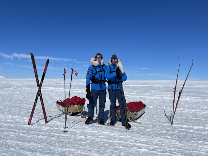
In an astonishing feat of endurance, explorers Justin Packshaw and Jamie Facer Childs are a quarter of the way through a 3600-km kitesurf trek that takes them across the desolate heart of Antarctica. They are not pushing their physical and mental limits to the brink, facing howling gales and temperatures of –55°C just for the sake of adventure. They are gathering information to help scientists better understand how the body responds to extremes and taking unique measurements of their ice environment that will help complement ESA’s CryoSat mission to better understand how this giant ice sheet is evolving in response to climate change.
Kitesurfing the white wilderness for polar science
16.12.2021 11:40 ESA Observing the Earth
In an astonishing feat of endurance, explorers Justin Packshaw and Jamie Facer Childs are a quarter of the way through a 3600-km kitesurf trek that takes them across the desolate heart of Antarctica. They are not pushing their physical and mental limits to the brink, facing howling gales and temperatures of –55°C just for the sake of adventure. They are gathering information to help scientists better understand how the body responds to extremes and taking unique measurements of their ice environment that will help complement ESA’s CryoSat mission to better understand how this giant ice sheet is evolving in response to climate change.
EASA zveřejnila NPA k U-space regulaci
16.12.2021 10:51 UAVAEASA dnes zveřejnila NPA k U-Space schválené regulaci, s podrobným návrhem AMC a GM, které vytvořila Drone expert group, v které byl i prezident UAVA. Současně je nyní možnost do 15.3.2022 dávat komentáře k tomuto NPA. NPA ke stažení zde: https://www.easa.europa.eu/newsroom-and-events/news/easa-publishes-proposal-implementation-u-space-europe
The post EASA zveřejnila NPA k U-space regulaci appeared first on UAV Aliance pro bezpilotní letecký průmysl.
Hexagon’s police records system deployed by San Angelo, Texas
16.12.2021 10:30 Hexagon Safety & InfrastructureMáme 2 nové profesory geoinformatiky – gratulujeme!
16.12.2021 5:31 GISportal.cz
Prezident republiky Miloš Zeman jmenoval ve středu dne 15. prosince 2021 na návrhy vědeckých a uměleckých rad vysokých škol nové profesorky a profesory vysokých škol. Rozhodnutí prezidenta republiky podléhá kontrasignaci předsedou vlády. Jmenovací dekrety předá ministr školství, mládeže a tělovýchovy. doc. Dr. Ing. Jiří HORÁK, pro obor: Geoinformatika na návrh Vědecké rady Vysoké školy báňské – […]
The post Máme 2 nové profesory geoinformatiky – gratulujeme! appeared first on GISportal.cz.
Maxar Reserves May 15 - June 13 Window for First WorldView Legion Launch
16.12.2021 0:24 GISCafe.com Webcasts-Webinars WESTMINSTER, Colo. — (BUSINESS WIRE) — December 15, 2021 —Maxar Technologies (NYSE:MAXR) (TSX:MAXR), provider of comprehensive …
Topcon Positioning Group expands global headquarters
16.12.2021 0:08 GISCafe.com Webcasts-Webinars LIVERMORE, Calif. – December 15, 2021 – Topcon Positioning Group has announced the opening of the new John D. Dice Training Center at its …GIS & Assessment Communities Poised to Gather in New Orleans
15.12.2021 23:51 GISCafe.com Webcasts-Webinars Des Plaines, IL (December 15, 2021) For twenty-five years, URISA and the International Association of Assessing Officers (IAAO) have …SCHNEIDER ELECTRIC ANNOUNCES LATEST RELEASE OF ARCFM DESIGNER XI
15.12.2021 23:51 GISCafe.com Webcasts-Webinars One of the most significant releases to date, ArcFM Designer 11.3.3 delivers valuable new capabilities for designers and engineersFort Collins, …
NSGIC Releases Findings from 2021 Geospatial Maturity Assessment
15.12.2021 23:43 GISCafe.com Webcasts-Webinars December 15, 2021
The National States Geographic Information Council (NSGIC) has released its 2021 comprehensive Geospatial Maturity …
Innoviz Technologies' First InnovizTwo LiDAR to be Presented at CES® 2022 According to Plan
15.12.2021 19:29 GISCafe.com Webcasts-Webinars - Innoviz announces the successful launch of the first B samples of the automotive-grade InnovizTwo LiDAR sensor.TEL AVIV, Israel, Dec. 15, 2021 …
MapQuest for Business Integrates with Epic
15.12.2021 19:29 GISCafe.com Webcasts-Webinars MapQuest Business-to-Business (B2B) service has been selected to provide mapping/navigation and geolocation services for leading health information …Lucas Emanuel Martins Proves Going Digital in Water Distribution Analysis is Ethically Responsible
15.12.2021 18:53 Bentley SystemsPressCoverage
Lucas Emanuel Martins Proves Going Digital in Water Distribution Analysis is Ethically Responsible
Read the articleSwarm and Cluster get to the bottom of geomagnetic storms
15.12.2021 17:10 ESA Observing the Earth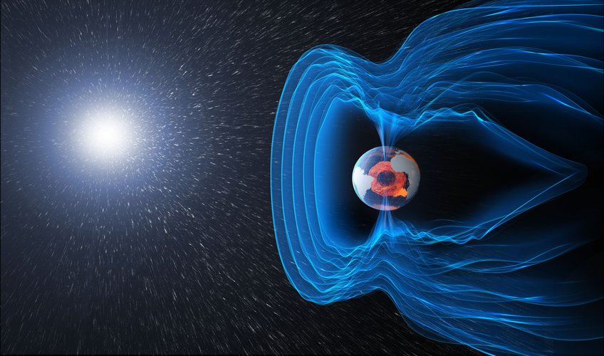
The notion of living in a bubble is usually associated with negative connotations, but all life on Earth is dependent on the safe bubble created by our magnetic field. Understanding how the field is generated, how it protects us and how it sometimes gives way to charged particles from the solar wind is not just a matter of scientific interest, but also a matter of safety. Using information from ESA’s Cluster and Swarm missions along with measurements from the ground, scientists have, for the first time, been able to confirm that curiously named bursty bulk flows are directly connected to abrupt changes in the magnetic field near Earth’s surface, which can cause damage to pipelines and electrical power lines.
Swarm and Cluster get to the bottom of geomagnetic storms
15.12.2021 17:10 ESA Observing the Earth
The notion of living in a bubble is usually associated with negative connotations, but all life on Earth is dependent on the safe bubble created by our magnetic field. Understanding how the field is generated, how it protects us and how it sometimes gives way to charged particles from the solar wind is not just a matter of scientific interest, but also a matter of safety. Using information from ESA’s Cluster and Swarm missions along with measurements from the ground, scientists have, for the first time, been able to confirm that curiously named bursty bulk flows are directly connected to abrupt changes in the magnetic field near Earth’s surface, which can cause damage to pipelines and electrical power lines.
SkyWatch Launches TerraStream Certified Solutions Provider Program to Offer End-to-End Ecosystem Support for Satellite Operators
15.12.2021 16:47 GISCafe.com Webcasts-Webinars PARIS, France, Dec. 15, 2021 (GLOBE NEWSWIRE) -- SkyWatch Space Applications Inc. ("SkyWatch"), a leading provider of machine-to-machine (M2M) …Virgin Orbit Expands Space Solutions Business With Hypersat Investment
15.12.2021 16:47 GISCafe.com Webcasts-Webinars PARIS — (BUSINESS WIRE) — December 15, 2021 —WORLD SATELLITE BUSINESS WEEK--Virgin Orbit, the responsive launch and space …
Trimble Acquires AgileAssets to Expand its Infrastructure Software Solutions Portfolio
15.12.2021 16:47 GISCafe.com Webcasts-Webinars SUNNYVALE, Calif., Dec. 15, 2021 — (PRNewswire) — Trimble (NASDAQ: TRMB) announced today it has acquired AgileAssets, a provider …Teren, Formerly SolSpec, Raises $4 Million to Address Growing ESG and Geospatial Markets
15.12.2021 16:47 GISCafe.com Webcasts-Webinars The rebrand promotes Teren's focus on 4D analytics for remotely sensed dataDENVER, Dec. 15, 2021 — (PRNewswire) — Teren, formerly …
Galileo Open Service Definition Document version 1.2 now available for download
15.12.2021 16:12 European GNSS Agency
The "Galileo - Open Service - Service Definition Document" (Galileo OS SDD) defines the Minimum Performance Levels (MPLs) of the Galileo Open Service (OS). Find out what billions of users of Galileo can expect.
The European Union Agency for the Space Programme (EUSPA) together with the European Commission announce the publication of the latest version of the Galileo Open Service Definition Document (OS SDD). The Galileo Open Service Definition Document (OS SDD) was updated on November 2021 to reflect upgrades in the Galileo system since the publication of the previous version in May 2019. The latest version, 1.2, can be found on the GSC web portal on this link.
The SDD has been updated to include improvements of the Open Service, accounting for the current constellation and updates in the ground infrastructure that increase its robustness. This is the last update foreseen before Galileo Open Service reaches Full Operational Capability (FOC).
The updated SDD provides better Minimum Performance Levels (MPLs) for signal and position availability, updated definitions of some timing MPLs, and establishes a more stringent commitment on the time to publish Notice Advisories to Galileo Users (NAGUs). In addition, the concept of auxiliary satellites has been added, while some sections have been reworded to improve clarity.
Galileo Open Service Definition Document (OS SDD) at glance
As in previous versions, the main information in the SDD includes:
- Service terms and conditions of use.
- Service characteristics (scope, general concepts, assumptions, reference systems).
- Service performance (Minimum Performance Levels and their associated conditions and constraints).
- Annexes (providing further details on the parameters, expected performance evolutions, additional metrics and the description of NAGUs).
Users are invited to download and read the updated “Galileo Open Service Definition Document (SDD)” to discover the improvements of the Open Service and learn about its main characteristics and performance. For more details on Galileo performance and its services, please contact the Galileo Help Desk. Moreover, to receive NAGUs and notifications of new Galileo publications, please register to the GSC web portal and subscribe to our newsletters.
Media note: This feature can be republished without charge provided the European Union Agency for the Space Programme (EUSPA) is acknowledged as the source at the top or the bottom of the story. You must request permission before you use any of the photographs on the site. If you republish, we would be grateful if you could link back to the EUSPA website (http://www.euspa.europa.eu).
Omezeni úředních hodin
15.12.2021 15:34 ČÚZK - předpisy a opatření Zeměměřický a katastrální inspektorát v Pardubicích zveřejnil novou aktualitu: Omezeni úředních hodin 23.12.2021 Vážení klienti,úřední hodiny na Zeměměřickém a katastrálním inspektorátu v Pardubicích budou z provozních důvodů upraveny takto:
čtvrtek 23. 12. 2021
od 8,00 h do 12,00 h
Děkujeme za pochopení.
Omezeni úředních hodin
15.12.2021 15:34 ČÚZK /Urady/Zememericke-a-katastralni-inspektoraty/Zememericke-a-katastralni-inspektoraty/Zememericky-a-katastralni-inspektorat-v-Pardubicic/O-uradu/Aktuality/Omezeni-urednich-hodin5 Years of Galileo Services
15.12.2021 13:09 European GNSS Agency
On December 15th 2016 the Galileo Services were declared operational, marking a cornerstone in the field of satellite navigation for European citizens and worldwide. Since then, the EU Agency for the Space Programme has endeavored to increase the robustness of the system and services, enhance market adoption and offer new services to its users.
From the declaration of services, users worldwide from several domains have been reaping the benefits offered by European Union Galileo Programme. To celebrate its 5th anniversary, we want to share some Galileo milestones!
1. Galileo Open Service performances rank 1 among all GNSS service providers worldwide
The Galileo state of the art Open Service (OS) is providing free of charge outstanding seamless performance to users worldwide, in terms of ranging, positioning and timing. The Open Service performance ranks first among all GNSS service providers. The improvement of the service remains a priority, with a stronger commitment to liaise with users with the publication of Notice Advisories to Galileo Users (NAGUs), with updates of the ground infrastructure and the current constellation. A new version of the Galileo Open Service Definition Document (OS SDD) will be published soon through the GSC web portal with better Minimum Performance Levels (MPLs) for signal and position availability. Stay Connected to read the new version!
2. SAR/Galileo service and rescue mission
Galileo supports the international Search And Rescue (SAR) satellite services. It is transmitting distress signals from SAR beacons, operating to COSPAS-SARSAT standards, and relaying through the Galileo specific Return-Link Service (RLS) the responses to those beacons equipped with Galileo receivers. The Return-Link Service unique and pioneering feature of Galileo was declared operational in January 2020. The Galileo RLS allows people in distress to receive an automatic acknowledgement that their signal has been picked up by the first responders. Galileo’s contribution to the Medium Earth Orbit Satellites Search and Rescue System (MEOSAR) managed by the International COSPAS-SARSAT Programme translates into 2000 lives saved per year. For example, in November 2020, this SAR/Galileo “lifesaver” service provided in less than 3 minutes key information leading to the successful rescue of a sailor in distress during the Vendee Globe Yacht race.
3. New Galileo service differentiator: High Accuracy Service (HAS)
The first-ever broadcast of High Accuracy Service test signal occurred on 19 May 2021 thanks to Galileo. This service will provide high accuracy data, enabling sub-meter level positioning accuracy. The initial performances are promising. Galileo is dressing the scene for the year to come.
4. Galileo getting in our daily lives and professional applications
Galileo is not only satellites and services: since 2016, Galileo entered quickly in our daily lives, in our cars, smartphones, drones and is enhancing many professional domains, such as maritime navigation, agriculture and geomatics. EUSPA’s market and user-driven approach has led to this success, developing innovative applications and receivers involving the growing GNSS downstream industry and SMEs, consulting with users, and launching innovation challenges for new space entrepreneurs.
As of today, more than 2.4 billion Galileo-enabled smartphones are sold worldwide. It is a stunning number considering that the first Galileo-enabled smartphone only hit the market in 2016. Since April 2018, all new car models in the European Union are equipped with eCall technology that includes Galileo. In the event of a serious accident, eCall automatically dials 112 - Europe's single emergency number – providing the accurate position of the crashed vehicle to help the first responders reach the site faster.
What is next for Galileo?
The Galileo system robustness is being continuously improved to ensure seamless, safe and secured service delivery 24/7 to users worldwide.
The Public Regulated Service (PRS) of Galileo is expected to reach Initial Operational Capability by the end of 2023.
EUSPA is currently working on delivering next-generation services based on Galileo’s precise signals, timing capabilities, and robust performance.
Visit the GNSS Service Centre website www.gsc-europa.eu for all details on Galileo service performance
Undertaken by a European partnership, the European Commission manages Galileo, with EUSPA overseeing Galileo operations and service provision and ESA as the design authority overseeing its development, procuring satellites, and the ground segment.
Media note: This feature can be republished without charge provided the European Union Agency for the Space Programme (EUSPA) is acknowledged as the source at the top or the bottom of the story. You must request permission before you use any of the photographs on the site. If you republish, we would be grateful if you could link back to the EUSPA website (http://www.euspa.europa.eu).
5 Years of Galileo Services
15.12.2021 13:09 European GNSS AgencyOn December 15th 2016 the Galileo Services were declared operational, marking a cornerstone in the field of satellite navigation for European citizens and worldwide. Since then, the EU Agency for the Space Programme has endeavored to increase the robustness of the system and services, enhance market adoption and offer new services to its users.
From the declaration of services, users worldwide from several domains have been reaping the benefits offered by European Union Galileo Programme. To celebrate its 5th anniversary, we want to share some Galileo milestones!
1. Galileo Open Service performances rank 1 among all GNSS service providers worldwide
The Galileo state of the art Open Service (OS) is providing free of charge outstanding seamless performance to users worldwide, in terms of ranging, positioning and timing. The Open Service performance ranks first among all GNSS service providers. The improvement of the service remains a priority, with a stronger commitment to liaise with users with the publication of Notice Advisories to Galileo Users (NAGUs), with updates of the ground infrastructure and the current constellation. A new version of the Galileo Open Service Definition Document (OS SDD) will be published soon through the GSC web portal with better Minimum Performance Levels (MPLs) for signal and position availability. Stay Connected to read the new version!
2. SAR/Galileo service and rescue mission
Galileo supports the international Search And Rescue (SAR) satellite services. It is transmitting distress signals from SAR beacons, operating to COSPAS-SARSAT standards, and relaying through the Galileo specific Return-Link Service (RLS) the responses to those beacons equipped with Galileo receivers. The Return-Link Service unique and pioneering feature of Galileo was declared operational in January 2020. The Galileo RLS allows people in distress to receive an automatic acknowledgement that their signal has been picked up by the first responders. Galileo’s contribution to the Medium Earth Orbit Satellites Search and Rescue System (MEOSAR) managed by the International COSPAS-SARSAT Programme translates into 2000 lives saved per year. For example, in November 2020, this SAR/Galileo “lifesaver” service provided in less than 3 minutes key information leading to the successful rescue of a sailor in distress during the Vendee Globe Yacht race.
3. New Galileo service differentiator: High Accuracy Service (HAS)
The first-ever broadcast of High Accuracy Service test signal occurred on 19 May 2021 thanks to Galileo. This service will provide high accuracy data, enabling sub-meter level positioning accuracy. The initial performances are promising. Galileo is dressing the scene for the year to come.
4. Galileo getting in our daily lives and professional applications
Galileo is not only satellites and services: since 2016, Galileo entered quickly in our daily lives, in our cars, smartphones, drones and is enhancing many professional domains, such as maritime navigation, agriculture and geomatics. EUSPA’s market and user-driven approach has led to this success, developing innovative applications and receivers involving the growing GNSS downstream industry and SMEs, consulting with users, and launching innovation challenges for new space entrepreneurs.
As of today, more than 2.4 billion Galileo-enabled smartphones are sold worldwide. It is a stunning number considering that the first Galileo-enabled smartphone only hit the market in 2016. Since April 2018, all new car models in the European Union are equipped with eCall technology that includes Galileo. In the event of a serious accident, eCall automatically dials 112 - Europe's single emergency number – providing the accurate position of the crashed vehicle to help the first responders reach the site faster.
What is next for Galileo?
The Galileo system robustness is being continuously improved to ensure seamless, safe and secured service delivery 24/7 to users worldwide.
The Public Regulated Service (PRS) of Galileo is expected to reach Initial Operational Capability by the end of 2023.
EUSPA is currently working on delivering next-generation services based on Galileo’s precise signals, timing capabilities, and robust performance.
Visit the GNSS Service Centre website www.gsc-europa.eu for all details on Galileo service performance
Media note: This feature can be republished without charge provided the European Union Agency for the Space Programme (EUSPA) is acknowledged as the source at the top or the bottom of the story. You must request permission before you use any of the photographs on the site. If you republish, we would be grateful if you could link back to the EUSPA website (http://www.euspa.europa.eu).
Nedostupné produkční prostředí ISÚI
15.12.2021 12:00 ČÚZK /ruian/Editacni-agendovy-system-ISUI/Provozni-informace-a-odstavky/Archiv-PROD/Nedostupne-produkcni-prostredi-ISUI-(30)20211215 - odstávka ISÚI
15.12.2021 11:39 ČÚZK /ruian/Novinky-RUIAN/Archiv-novinek-RUIAN/2021/20210628-odstavka-ISUIvýběrové řízení na KP Pelhřimov
15.12.2021 10:19 ČÚZK /Urady/Katastralni-urady/Katastralni-urady/Katastralni-urad-pro-Vysocinu/O-uradu/Aktuality/vyberove-rizeni-na-KP-Pelhrimov-(3)výběrové řízení na KP Pelhřimov 2
15.12.2021 10:19 ČÚZK - předpisy a opatření Katastrální úřad pro Vysočinu zveřejnil novou aktualitu: Oznámení o vyhlášení výběrového řízení na služební místo rada/odborný rada v oddělení aktualizace KN Katastrálního pracoviště Pelhřimov.výběrové řízení na KP Pelhřimov 2
15.12.2021 10:19 ČÚZK /Urady/Katastralni-urady/Katastralni-urady/Katastralni-urad-pro-Vysocinu/O-uradu/Aktuality/vyberove-rizeni-na-KP-Pelhrimov-(3)výběrové řízení na KP Pelhřimov 2
15.12.2021 10:19 ČÚZK - předpisy a opatření Katastrální úřad pro Vysočinu - Katastrální pracoviště Pelhřimov zveřejnil novou aktualitu: Oznámení o vyhlášení výběrového řízení na služební místo rada/odborný rada v oddělení aktualizace KN Katastrálního pracoviště Pelhřimov.výběrové řízení na KP Pelhřimov
15.12.2021 10:19 ČÚZK - předpisy a opatření Katastrální úřad pro Vysočinu zveřejnil novou aktualitu: Oznámení o vyhlášení výběrového řízení na služební místo rada/odborný rada v oddělení aktualizace KN Katastrálního pracoviště Pelhřimov.Končí aplikace ArcGIS Collector, Tracker a Explorer
15.12.2021 10:00 ARCDATAPřipomínáme, že s koncem roku 2021 končí i podpora aplikací ArcGIS Collector, ArcGIS Explorer a ArcGIS Tracker (pro iOS i Android). Definitivně je tedy nahradí mobilní aplikace ArcGIS Field Maps, kde najdete všechny funkce končících aplikací na jednom místě.
Co to pro uživatele znamená?
- Pro tyto produkty již nebude poskytována technická podpora.
- Nebudou vydávány žádné aktualizace ani opravy chyb.
- Dokumentace zůstane dostupná, ale nebude aktualizovaná.
- Aby uživatelé využívali především všeobecně dostupné produkty, budou vyzváni k aktualizaci svých aplikací.
Přechod do aplikace ArcGIS Field Maps má mnoho výhod a nemusíte se ho obávat. Není potřeba měnit uživatelské licence ani není třeba učit se novým postupům. Aplikace je v provozu déle než rok a více se o ní můžete dozvědět v článku na našem blogu nebo ze záznamu workshopu, který proběhl v rámci letošní Konference GIS Esri v ČR a který jsme při této příležitosti uvolnili k volnému zhlédnutí.

rada_odborný rada_aktualizace_KP Pelhřimov
15.12.2021 9:49 ČÚZK - předpisy a opatření Katastrální úřad pro Vysočinu Katastrální pracoviště Pelhřimovvypisuje výběrové řízení na místo
rada_odborný rada_aktualizace_KP Pelhřimov
rada_odborný rada_aktualizace_KP Pelhřimov
15.12.2021 9:49 ČÚZK /Urady/Katastralni-urady/Katastralni-urady/Katastralni-urad-pro-Vysocinu/Uredni-deska/Oznameni-a-jina-uredni-sdeleni/Volna-mista/DMS/rada_odborny-rada_aktualizace_KP-Pelhrimovrada_odborný rada_aktualizace_KP Pelhřimov
15.12.2021 9:49 ČÚZK - volná místa Katastrální úřad pro Vysočinu Katastrální pracoviště Pelhřimov vypisuje výběrové řízení na místo rada_odborný rada_aktualizace_KP Pelhřimov20211216 - volné místo - Vedoucí OOKO I. v TO na Katastrálním úřadu pro Ústecký kraj
15.12.2021 9:27 ČÚZK - předpisy a opatření Katastrální úřad pro Ústecký kraj zveřejnil novou aktualitu: Nabídka volného místa - služební místo představeného - Vedoucí oddělení obnovy katastrálního operátu I. v technickém odboru na Katastrálním úřadu pro Ústecký kraj20211216 - volné místo - Vedoucí OOKO I. v TO na Katastrálním úřadu pro Ústecký kraj
15.12.2021 9:27 ČÚZK /Urady/Katastralni-urady/Katastralni-urady/Katastralni-urad-pro-Ustecky-kraj/O-uradu/Aktuality/211216-volne-misto-Vedouci-OOKO-I-v TO-na-KatVedoucí oddělení obnovy katastrálního operátu I. v technickém odboru na Katastrálním úřadu pro Ústec
15.12.2021 9:24 ČÚZK - předpisy a opatření Katastrální úřad pro Ústecký kraj technický odborvypisuje výběrové řízení na místo
Vedoucí oddělení obnovy katastrálního operátu I. v technickém odboru na Katastrálním úřadu pro Ústecký kraj
Vedoucí oddělení obnovy katastrálního operátu I. v technickém odboru na Katastrálním úřadu pro Ústec
15.12.2021 9:24 ČÚZK - volná místa Katastrální úřad pro Ústecký kraj technický odbor vypisuje výběrové řízení na místo Vedoucí oddělení obnovy katastrálního operátu I. v technickém odboru na Katastrálním úřadu pro ÚstecVedoucí oddělení obnovy katastrálního operátu I. v technickém odboru na Katastrálním úřadu pro Ústec
15.12.2021 9:24 ČÚZK /Urady/Katastralni-urady/Katastralni-urady/Katastralni-urad-pro-Ustecky-kraj/Uredni-deska/Oznameni-a-jina-uredni-sdeleni/Volna-mista/DMS/Vedouci-oddeleni-obnovy-katastralniho-operatu-I-vOstění a překlady HELUZ – nová aplikace Arkance Systems pro Autodesk Revit
15.12.2021 8:36 Arkance SystemsUrychlení práce s usazováním překladů a doplňkových cihel ostění, které jsou pak snadno vykazovatelné. Zvýšení kvality projektové dokumentace
Zpráva Ostění a překlady HELUZ – nová aplikace Arkance Systems pro Autodesk Revit pochází z arkance-systems.cz.
rada/odborný rada – vedoucí oddělení potvrzování geometrických plánů
15.12.2021 7:37 ČÚZK - předpisy a opatření Katastrální úřad pro hlavní město Prahuvypisuje výběrové řízení na místo
rada/odborný rada – vedoucí oddělení potvrzování geometrických plánů
rada/odborný rada – vedoucí oddělení potvrzování geometrických plánů
15.12.2021 7:37 ČÚZK - volná místa Katastrální úřad pro hlavní město Prahu vypisuje výběrové řízení na místo rada/odborný rada – vedoucí oddělení potvrzování geometrických plánůrada/odborný rada – vedoucí oddělení potvrzování geometrických plánů
15.12.2021 7:37 ČÚZK - volná místa Katastrální úřad pro hlavní město Prahu - Katastrální pracoviště Praha vypisuje výběrové řízení na místo rada/odborný rada – vedoucí oddělení potvrzování geometrických plánůrada/odborný rada – vedoucí oddělení potvrzování geometrických plánů
15.12.2021 7:37 ČÚZK - předpisy a opatření Katastrální úřad pro hlavní město Prahu - Katastrální pracoviště Prahavypisuje výběrové řízení na místo
rada/odborný rada – vedoucí oddělení potvrzování geometrických plánů
E-learningová školení BIM softwaru – do konce roku výhodně!
15.12.2021 7:20 Arkance Systems2 nové rozsáhlé e-learning kurzy pro výuku základů BIM nyní pořídíte s výraznou slevou! Jen do konce roku 2021.
Zpráva E-learningová školení BIM softwaru – do konce roku výhodně! pochází z arkance-systems.cz.
Státní pozemkový úřad vyhlašuje 15. ročník soutěže Žít krajinou
15.12.2021 0:00 Státní pozemkový úřad Praha, 15. prosince 2021 – Symbolicky 15. prosince v 15:00 Státní pozemkový úřad (SPÚ) vyhlásil 15. ročník soutěže Žít krajinou 2021. Soutěž zaměřenou na komplexní pozemkové úpravy pořádá SPÚ ve spolupráci s Českomoravskou komorou pro pozemkové úpravy (ČMKPÚ) již od roku 2006. Krajské pobočky SPÚ, projektanti, stavitelé nebo obce či vlastníci realizované stavby mohou své projekty přihlásit do 20. února 2022. Soutěž podporuje projekty, které svým charakterem splňují požadavky na celkové řešení krajiny nebo její části. Přihlásit lze takové projekty, které byly dokončeny nejpozději 31. prosince 2020.Státní pozemkový úřad vyhlašuje 15. ročník soutěže Žít krajinou
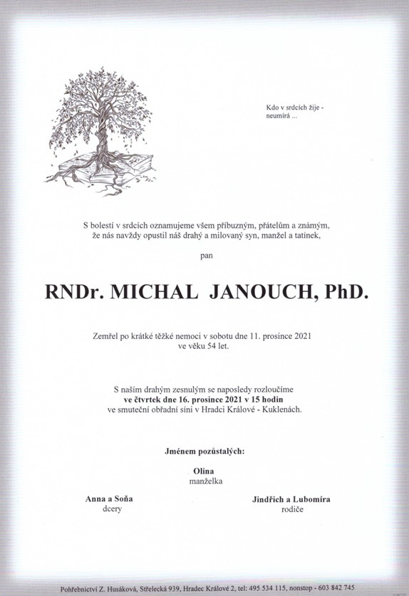
15.12.2021 0:00 Státní pozemkový úřad Praha, 15. prosince 2021 – Symbolicky 15. prosince v 15:00 Státní pozemkový úřad (SPÚ) vyhlásil 15. ročník soutěže Žít krajinou 2021. Soutěž zaměřenou na komplexní pozemkové úpravy pořádá SPÚ ve spolupráci s Českomoravskou komorou pro pozemkové úpravy (ČMKPÚ) již od roku 2006. Krajské pobočky SPÚ, projektanti, stavitelé nebo obce či vlastníci realizované stavby mohou své projekty přihlásit do 20. února 2022. Soutěž podporuje projekty, které svým charakterem splňují požadavky na celkové řešení krajiny nebo její části. Přihlásit lze takové projekty, které byly dokončeny nejpozději 31. prosince 2020.Smutná zpráva
15.12.2021 0:00 Geografický ústav MUDne 11. prosince 2021 nás ve věku 54 let opustil RNDr. Michal Janouch, Ph.D., člen Hlavního výboru České geografické společnosti a dlouholetý předseda Polární sekce.
Michal Janouch vystudoval Katedru geografie PřF MU, od dětství se zajímal o polární oblasti a účastnil se řady antarktických expedic, na kterých se zabýval měřením ozonu a ultrafialového záření.
Prosíme, věnujte mu vzpomínku.
Kolegové z Geografického ústavu.
Smutná zpráva
15.12.2021 0:00 Geografický ústav MUDne 11. prosince 2021 nás ve věku 54 let opustil RNDr. Michal Janouch, Ph.D., člen Hlavního výboru České geografické společnosti a dlouholetý předseda Polární sekce.
Michal Janouch vystudoval Katedru geografie a kartografie PřF MU, od dětství se zajímal o polární oblasti a účastnil se řady antarktických expedic, na kterých se zabýval měřením ozonu a ultrafialového záření.
Prosíme, věnujte mu vzpomínku.
Kolegové z Geografického ústavu.
Smutná zpráva
15.12.2021 0:00 Geografický ústav MUDne 11. prosince 2021 nás ve věku 54 let opustil RNDr. Michal Janouch, Ph.D., člen Hlavního výboru České geografické společnosti a dlouholetý předseda Polární sekce.
Michal Janouch vystudoval Katedru geografie, od dětství se zajímal o polární oblasti a účastnil se řady antarktických expedic, na kterých se zabýval měřením ozonu a ultrafialového záření.
Prosíme, věnujte mu vzpomínku.
Kolegové z Geografického ústavu.
Nová aplikace MAWIS ContractSupport
14.12.2021 23:30 Hrdlička Smlouvy, dokumenty a návrhy na vklad do katastru lusknutím prstu.MnDOT Rebuilds Gateway to Greater Minnesota by Going Digital
14.12.2021 21:24 Bentley SystemsPressCoverage
MnDOT Rebuilds Gateway to Greater Minnesota by Going Digital
Read the articleSatRevolution Secures Series B Funding from Virgin Orbit
14.12.2021 21:19 GISCafe.com Webcasts-Webinars Transaction cements strategic partnership between SatRevolution and Virgin OrbitThe total Series B fundraise is estimated to close at $30 …
100+ geospatial and built world technology solutions providers to exhibit at Geo Week
14.12.2021 21:19 GISCafe.com Webcasts-Webinars Exhibit floor nearly sold out for in-person event Feb 6-8, in Denver CO. Organizers of Geo Week, the single powerhouse event that champions the …Ve vánoční hře Mapy.cz můžete vysvobodit princeznu ze spárů draka
14.12.2021 20:43 GeoBusinessPortál Mapy.cz na své facebookové stránce informoval o vánoční hře. „Pozor, pozor, pan král na vědomí dává, že princeznu unesl strašlivý drak. Kdo ji osvobodí, toho čeká odměna vskutku královská. Stačí mít bystrý úsudek a Mapy.cz.“ Hru můžete začít kliknutím na vánoční hvězdu, která na vás bude svítit v základním pohledu na celou Českou republiku. […]
The post Ve vánoční hře Mapy.cz můžete vysvobodit princeznu ze spárů draka appeared first on GeoBusiness.
Ve vánoční hře Mapy.cz můžete vysvobodit princeznu ze spárů draka
14.12.2021 20:43 GeoBusinessPortál Mapy.cz na své facebookové stránce informoval o vánoční hře. „Pozor, pozor, pan král na vědomí dává, že princeznu unesl strašlivý drak. Kdo ji osvobodí, toho čeká odměna vskutku královská. Stačí mít bystrý úsudek a Mapy.cz.“ Hru můžete začít kliknutím na vánoční hvězdu, která na vás bude svítit v základním pohledu na celou Českou republiku. Hra začíná u bubeníka, […]
The post Ve vánoční hře Mapy.cz můžete vysvobodit princeznu ze spárů draka appeared first on GeoBusiness.
Ve vánoční hře Mapy.cz můžete vysvobodit princeznu ze spárů draka
14.12.2021 20:43 GeoBusiness Portál Mapy.cz na své facebookové stránce informoval o vánoční hře. „Pozor, pozor, pan král na vědomí dává, že princeznu unesl strašlivý drak. Kdo ji osvobodí, toho čeká odměna vskutku královská. Stačí mít bystrý úsudek a Mapy.cz.“ Hru můžete začít kliknutím na vánoční hvězdu, která na vás bude svítit v základním pohledu na celou Českou republiku. Hra začíná u bubeníka, […]Ve vánoční hře Mapy.cz můžete vysvobodit princeznu ze spárů draka
14.12.2021 20:43 GeoBusiness Portál Mapy.cz na své facebookové stránce informoval o vánoční hře. „Pozor, pozor, pan král na vědomí dává, že princeznu unesl strašlivý drak. Kdo ji osvobodí, toho čeká odměna vskutku královská. Stačí mít bystrý úsudek a Mapy.cz.“ Hru můžete začít kliknutím na vánoční hvězdu, která na vás bude svítit v základním pohledu na celou Českou republiku. […]Transportation Manager and Mastermind: Dan Mulder Oversees the Trucks that Move Our Goods
14.12.2021 19:52 Bentley SystemsPressCoverage
Dan Mulder Oversees the Trucks that Move Our Goods
Read the articleAktualizace otevřených dat zastávek veřejné dopravy v Jihočeském kraji
14.12.2021 18:24 Jihočeský krajV sekci Doprava a silniční hospodářství byla aktualizována data zastávek veřejné dopravy v Jihočeském kraji k 14.12.2021. Data jsou k dispozici ke stažení pod licencí CC0 nebo pomocí webových služeb (WMS, WFS) či k zobrazení v mapové aplikaci.
Innoviz Selected to Participate in LiDAR Sensor Standards Consortium
14.12.2021 18:19 GISCafe.com Webcasts-Webinars OEMs and Tier 1 suppliers begin project to establish standardization for LiDAR testing, ensuring safe autonomous vehiclesTEL AVIV, Israel, Dec. 14, …
Orbital Insight Unveils Multiclass Object Detection Algorithms for Ships, Aircraft and Vehicles
14.12.2021 18:19 GISCafe.com Webcasts-Webinars Geospatial intelligence platform uses state-of-the-art advanced computer vision algorithms and high-resolution satellite imagery to identify …Aeolus paves the way for future wind lidars in space
14.12.2021 16:35 ESA Observing the Earth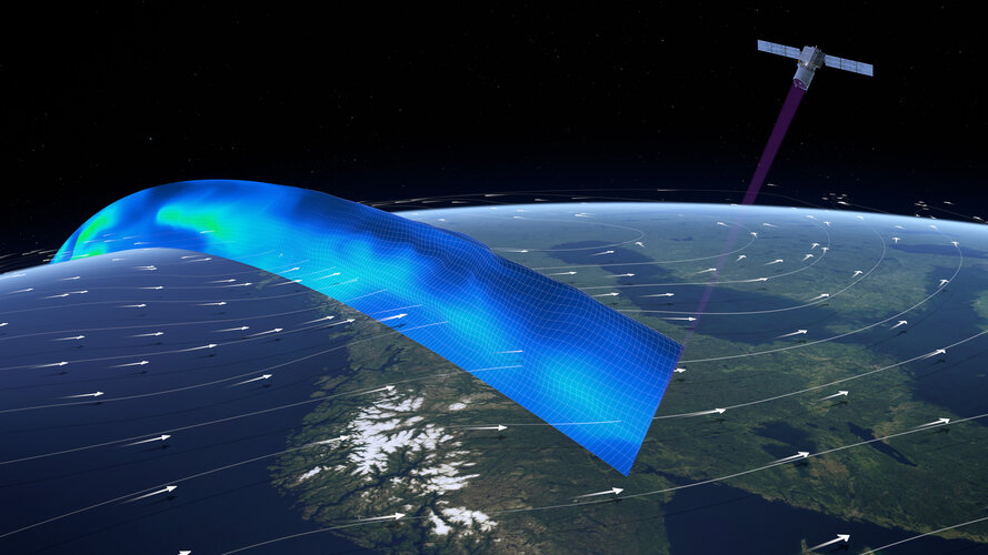
It’s hard to believe that ESA’s Aeolus wind mission has now been orbiting Earth for three years and, remarkably, exceeded its design life milestone. Aeolus has gone way further than its original goal of demonstrating that ground-breaking laser technology can deliver global profiles of the wind; its data are being distributed to weather forecasting services across the world in less than three hours of measurements being made in space. Moreover, Aeolus has laid the foundation for future Doppler wind lidar satellite missions.
Aeolus paves the way for future wind lidars in space
14.12.2021 16:35 ESA Observing the Earth
It’s hard to believe that ESA’s Aeolus wind mission has now been orbiting Earth for three years and, remarkably, exceeded its design life milestone. Aeolus has gone way further than its original goal of demonstrating that ground-breaking laser technology can deliver global profiles of the wind; its data are being distributed to weather forecasting services across the world in less than three hours of measurements being made in space. Moreover, Aeolus has laid the foundation for future Doppler wind lidar satellite missions.
Fujian Yongfu Power Engineering Saves CNY 400 Million
14.12.2021 16:24 Bentley SystemsPressCoverage
Fujian Yongfu Power Engineering Saves CNY 400 Million Using Integrated Geotechnical and Structural Offshore Design Technology
Read the articleFujian Yongfu Power Engineering Saves CNY 400 Million
14.12.2021 16:24 Bentley SystemsPressCoverage
Fujian Yongfu Power Engineering Saves CNY 400 Million Using Integrated Geotechnical and Structural Offshore Design Technology
Read the articleFujian Yongfu Power Engineering Saves CNY 400 Million
14.12.2021 16:24 Bentley SystemsPressCoverage
Fujian Yongfu Power Engineering Saves CNY 400 Million Using Integrated Geotechnical and Structural Offshore Design Technology
Read the articleFujian Yongfu Power Engineering Saves CNY 400 Million
14.12.2021 16:24 Bentley SystemsPressCoverage
Fujian Yongfu Power Engineering Saves CNY 400 Million Using Integrated Geotechnical and Structural Offshore Design Technology
Read the articleEnvision the Future of Autonomous Solutions with Velodyne Lidar at CES 2022
14.12.2021 15:28 GISCafe.com Webcasts-Webinars Velodyne Showcases Lidar-based Solutions for Automotive, Industrial, Infrastructure, RoboticsSAN JOSE, Calif. — (BUSINESS WIRE) — …
Securitas France Partners With Quanergy to Unveil the Security Market’s First Mobile Surveillance Solution With Integrated 3D LiDAR Technology
14.12.2021 15:28 GISCafe.com Webcasts-Webinars Mobile solution can be deployed anywhere to ensure security of remote sitesCost-effective, flexible security solution for sites with limited …
infiniDome, Honeywell and Easy Aerial Demonstrate the First UAV-Tailored Resilient Navigation Solution to Complete Critical Missions Under GPS Challenged and Denied Environments
14.12.2021 15:28 GISCafe.com Webcasts-Webinars CAESAREA, Israel — (BUSINESS WIRE) — December 14, 2021 —During November 2021, in Israel, infiniDome, Honeywell, and Easy Aerial …
CARTO Raises $61M to Accelerate Cloud Native Spatial Analytics in the Enterprise
14.12.2021 15:28 GISCafe.com Webcasts-Webinars NEW YORK, Dec. 14, 2021 — (PRNewswire) — CARTO, the cloud native spatial analysis platform, today announces the closure of a $61 million …D-Fend Solutions' Counter-Drone Technology Protected Airspace During the Pope's Visit and Holy Mass, Safeguarding Over 60,000 People
14.12.2021 15:28 GISCafe.com Webcasts-Webinars EnforceAir automatically detected and mitigated a do-it-yourself (DIY) drone in the airspace approaching the outdoor crowd, took control of it and …Knihovna geografie o vánočních prázdninách [Knihovna geografie, byTopic]
14.12.2021 13:35 Katedra aplikované geoinformatiky a kartografie Přf UK V období od 20.12.2021 do 2.1.2022 bude knihovna zcela uzavřena.Aktualizace údajů
14.12.2021 13:10 Ústecký kraj V Geoportálu ÚAP Ústeckého kraje byla provedena aktualizace údajů pro poskytovatele Český báňský úřad – jev 57, Národní památkový ústav - jev 5a, 8a, 10, České Radiokomunikace a.s. – jev 82a, Agentura ochrany přírody a krajiny České republiky – jev 27a, 32.EU space initiative to open up new opportunities for General Aviation across the Union
14.12.2021 11:53 European GNSS Agency
EUSPA launched a new initiative called "EUSPA Network of pilot projects" to facilitate the implementation of EGNOS-based procedures to non-instrument runways for general aviation and validate the safety assessment guidelines, published earlier in November.
Since its certification for use in civil aviation in 2011, EGNOS has become an important aid in the European aviation sector, increasing both the safety and accessibility of airports. Thanks to the accurate guidance offered by the system, pilots can easily land under challenging weather conditions such as poor visibility and avoid aborted landings (go-arounds).
From an airport perspective, EGNOS LPV approaches allow for instrument landings at lower costs as there is no need to install ground navigation aids. Satellite-based approaches by EGNOS are precise, stable, offer smoother glide paths and very high levels of availability.
As of today, more than 400 airports -mostly medium or large- in Europe rely on EGNOS-based approaches. General Aviation aerodromes usually rely on only VFR operations and have limited ground infrastructure. Even though the General Aviation (GA) community undertakes millions of flights on aircraft equipped with GNSS-receivers, it is not taking full advantage of the technology.
EUSPA worked together with the European Union Aviation Safety Agency (EASA) and other general aviation stakeholders on the strategy and other materials to support the implementation of EGNOS for general aviation to increase instrument approaches with EGNOS at non-instrument aerodromes. In December 2019, the safety promotion material for the implementation of EGNOS based procedures to general aviation was published followed by the safety assessment guidance material focusing on safety assessment development. One of the biggest challenges of the implementation of EGNOS-based approaches to non-instrument runways for general aviation is the safety assessment. EUSPA launched a new initiative called "EUSPA Network of pilot projects" to facilitate the implementation of EGNOS-based procedures to non-instrument runways for general aviation and validate the safety assessment guidelines.
Click here to read all you need to know about the "EUSPA Network of pilot projects"
Why invest in EGNOS?
Implementing EGNOS-based LPV procedures across European General Aviation airports brings numerous opportunities, from increasing flight traffic and boosting the economy of local communities to benefitting flight schools. SBAS approaches can help smaller airports create more connections for General and Business Aviation flights, while GA and BA pilots can rely on their instruments to land even under poor weather conditions such as decreased visibility.
About EGNOS
The European Geostationary Navigation Overlay Service, or EGNOS in short, is European Union regional satellite-based augmentation system (SBAS). SBASs are used to correct the performance of global navigation satellite systems, such as GPS. To do so, EGNOS uses a set of geostationary satellites and a network of ground stations to increase the accuracy of GPS. In the next 3 years, a new, more powerful system called "EGNOS V3" will become available and the user experience will be maximised through the strengthening of Galileo’s signal in addition to GPS’s.
Media note: This feature can be republished without charge provided the European Union Agency for the Space Programme (EUSPA) is acknowledged as the source at the top or the bottom of the story. You must request permission before you use any of the photographs on the site. If you republish, we would be grateful if you could link back to the EUSPA website (http://www.euspa.europa.eu).
Rada / odborný rada – řízení o údajích SGI v oddělení aktualizace KN Katastrálního pracoviště Valašs
14.12.2021 11:22 ČÚZK /Urady/Katastralni-urady/Katastralni-urady/Katastralni-urad-pro-Zlinsky-kraj/Uredni-deska/Oznameni-a-jina-uredni-sdeleni/Volna-mista/DMS/Rada-odborny-rada-–-rizeni-o-udajich-SGI-v-oddelRada / odborný rada – řízení o údajích SGI v oddělení aktualizace KN Katastrálního pracoviště Valašs
14.12.2021 11:22 ČÚZK - předpisy a opatření Katastrální úřad pro Zlínský kraj Katastrální pracoviště Valašské Meziříčívypisuje výběrové řízení na místo
Rada / odborný rada – řízení o údajích SGI v oddělení aktualizace KN Katastrálního pracoviště Valašské Meziříčí
Rada / odborný rada – řízení o údajích SGI v oddělení aktualizace KN Katastrálního pracoviště Valašs
14.12.2021 11:22 ČÚZK - volná místa Katastrální úřad pro Zlínský kraj Katastrální pracoviště Valašské Meziříčí vypisuje výběrové řízení na místo Rada / odborný rada – řízení o údajích SGI v oddělení aktualizace KN Katastrálního pracoviště Valašs20211214 - Duplicity ve změnových VFR
14.12.2021 11:06 ČÚZK /ruian/Poskytovani-udaju-ISUI-RUIAN-VDP/Vymenny-format-RUIAN-(VFR)/Archiv-novinek-VFR/2021/Duplicity-ve-zmenovych-VFRTerénní exkurze EduChange
14.12.2021 10:57 Katedra geoinformatiky UP OlomoucHledáte super C předmět (4 kredity) na letní semestr a ještě k tomu v angličtině? Už nemusíte hledat – terénní exkurze EduChange je po roční pauze opět zde. Co se naučíte? – jak vzdělávat o klimatické změně pomocí moderních technologií – něco málo o digitálních mapách, virtuální realitě a mobilních hrách – komunikovat v mezinárodním […]
The post Terénní exkurze EduChange appeared first on Katedra geoinformatiky.
Odborný referent/vrchní referent – správce informačních a komunikačních technologií
14.12.2021 10:03 ČÚZK /Urady/Katastralni-urady/Katastralni-urady/Katastralni-urad-pro-Moravskoslezsky-kraj/Uredni-deska/Oznameni-a-jina-uredni-sdeleni/Volna-mista/DMS/Odborny-referent-vrchni-referent-–-spravce-informaOdborný referent/vrchní referent – správce informačních a komunikačních technologií
14.12.2021 10:03 ČÚZK - volná místa Katastrální úřad pro Moravskoslezský kraj technický odbor vypisuje výběrové řízení na místo Odborný referent/vrchní referent – správce informačních a komunikačních technologiíOdborný referent/vrchní referent – správce informačních a komunikačních technologií
14.12.2021 10:03 ČÚZK - předpisy a opatření Katastrální úřad pro Moravskoslezský kraj technický odborvypisuje výběrové řízení na místo
Odborný referent/vrchní referent – správce informačních a komunikačních technologií
Odborný referent/vrchní referent – obnova katastrálního operátu
14.12.2021 9:57 ČÚZK - volná místa Katastrální úřad pro Moravskoslezský kraj Katastrální pracoviště Frýdek-Místek vypisuje výběrové řízení na místo Odborný referent/vrchní referent – obnova katastrálního operátuOdborný referent/vrchní referent – obnova katastrálního operátu
14.12.2021 9:57 ČÚZK - předpisy a opatření Katastrální úřad pro Moravskoslezský kraj Katastrální pracoviště Frýdek-Místekvypisuje výběrové řízení na místo
Odborný referent/vrchní referent – obnova katastrálního operátu
Odborný referent – obnova katastrálního operátu
14.12.2021 9:50 ČÚZK - volná místa Katastrální úřad pro Moravskoslezský kraj Katastrální pracoviště Bruntál vypisuje výběrové řízení na místo Odborný referent – obnova katastrálního operátuOdborný referent – obnova katastrálního operátu
14.12.2021 9:50 ČÚZK - předpisy a opatření Katastrální úřad pro Moravskoslezský kraj Katastrální pracoviště Bruntálvypisuje výběrové řízení na místo
Odborný referent – obnova katastrálního operátu
Odborný rada – ředitel Katastrálního pracoviště
14.12.2021 9:42 ČÚZK - volná místa Katastrální úřad pro Moravskoslezský kraj Katastrální pracoviště Frýdek-Místek vypisuje výběrové řízení na místo Odborný rada – ředitel Katastrálního pracovištěOdborný rada – ředitel Katastrálního pracoviště
14.12.2021 9:42 ČÚZK /Urady/Katastralni-urady/Katastralni-urady/Katastralni-urad-pro-Moravskoslezsky-kraj/Uredni-deska/Oznameni-a-jina-uredni-sdeleni/Volna-mista/DMS/Odborny-rada-–-reditel-Katastralniho-pracovisteOdborný rada – ředitel Katastrálního pracoviště
14.12.2021 9:42 ČÚZK - předpisy a opatření Katastrální úřad pro Moravskoslezský kraj Katastrální pracoviště Frýdek-Místekvypisuje výběrové řízení na místo
Odborný rada – ředitel Katastrálního pracoviště
Planet Reports Financial Results for Third Quarter of Fiscal 2022
14.12.2021 9:00 GISCafe.com Webcasts-Webinars Delivers Record Third Quarter Revenue of $31.7 MillionReaffirms Full Year Revenue Outlook for Fiscal Year 2022
End of Period Customer Count …
BlackSky Releases Images of Recent Tornado Devastation in Midwest and Southern U.S.
14.12.2021 9:00 GISCafe.com Webcasts-Webinars HERNDON, Va. — (BUSINESS WIRE) — December 12, 2021 — BlackSky’s (NYSE: BKSY) thoughts are with the families and communities …Změna výpůjční doby knihovny [Knihovna geografie, byTopic]
14.12.2021 8:25 Katedra aplikované geoinformatiky a kartografie Přf UK Z provozních důvodů se mění výpujční dobaBentley Systems Announces Seequent’s Acquisition of Advanced Resources and Risk Technology (AR2Tech)
14.12.2021 1:01 GISCafe.com Webcasts-Webinars Bringing State-of-the-Art Geostatistical Algorithms to the Geomodeling Community to Solve Complex Geospatial ProblemsEXTON, Pa. — (BUSINESS …