


![]()

zprávy
zdroje zpráv:20200416 - změna úředních hodin
16.4.2020 9:11 ČÚZK - předpisy a opatření Katastrální úřad pro Ústecký kraj zveřejnil novou aktualitu:S účinností od 20.4.2020 je provedena změna Úředních hodin na pracovištích Katastrálního úřadu pro Ústecký kraj.
Úřední hodiny jsou nově pro všechny agendy:
Pondělí : 8:00 - 17:00
Středa : 8:00 - 17:00
20200416 - změna úředních hodin
16.4.2020 9:11 ČÚZK /Urady/Katastralni-urady/Katastralni-urady/Katastralni-urad-pro-Ustecky-kraj/Katastralni-pracoviste/KP-Most/O-uradu/Aktuality/20200416-zmena-urednich-hodin20200416 - změna úředních hodin
16.4.2020 9:11 ČÚZK - předpisy a opatření Katastrální úřad pro Ústecký kraj zveřejnil novou aktualitu:S účinností od 20.4.2020 je provedena změna Úředních hodin na pracovištích Katastrálního úřadu pro Ústecký kraj.
Úřední hodiny jsou nově pro všechny agendy:
Pondělí : 8:00 - 17:00
Středa : 8:00 - 17:00
20200416 - změna úředních hodin
16.4.2020 9:11 ČÚZK /Urady/Katastralni-urady/Katastralni-urady/Katastralni-urad-pro-Ustecky-kraj/Katastralni-pracoviste/KP-Louny/O-uradu/Aktuality/20200416-zmena-urednich-hodin20200416 - změna úředních hodin
16.4.2020 9:10 ČÚZK - předpisy a opatření Katastrální úřad pro Ústecký kraj zveřejnil novou aktualitu:S účinností od 20.4.2020 je provedena změna Úředních hodin na pracovištích Katastrálního úřadu pro Ústecký kraj.
Úřední hodiny jsou nově pro všechny agendy:
Pondělí : 8:00 - 17:00
Středa : 8:00 - 17:00
20200416 - změna úředních hodin
16.4.2020 9:10 ČÚZK /Urady/Katastralni-urady/Katastralni-urady/Katastralni-urad-pro-Ustecky-kraj/Katastralni-pracoviste/KP-Litomerice/O-uradu/Aktuality/20200416-zmena-urednich-hodin20200416 - změna úředních hodin
16.4.2020 9:10 ČÚZK - předpisy a opatření Katastrální úřad pro Ústecký kraj zveřejnil novou aktualitu:S účinností od 20.4.2020 je provedena změna Úředních hodin na pracovištích Katastrálního úřadu pro Ústecký kraj.
Úřední hodiny jsou nově pro všechny agendy:
Pondělí : 8:00 - 17:00
Středa : 8:00 - 17:00
20200416 - změna úředních hodin
16.4.2020 9:10 ČÚZK /Urady/Katastralni-urady/Katastralni-urady/Katastralni-urad-pro-Ustecky-kraj/Katastralni-pracoviste/KP-Chomutov/O-uradu/Aktuality/20200416-zmena-urednich-hodin20200416 - změna úředních hodin
16.4.2020 9:08 ČÚZK - předpisy a opatření Katastrální úřad pro Ústecký kraj zveřejnil novou aktualitu:S účinností od 20.4.2020 je provedena změna Úředních hodin na pracovištích Katastrálního úřadu pro Ústecký kraj.
Úřední hodiny jsou nově pro všechny agendy:
Pondělí : 8:00 - 17:00
Středa : 8:00 - 17:00
20200416 - změna úředních hodin
16.4.2020 9:08 ČÚZK /Urady/Katastralni-urady/Katastralni-urady/Katastralni-urad-pro-Ustecky-kraj/Katastralni-pracoviste/KP-Decin/O-uradu/Aktuality/20200416-zmena-urednich-hodinKoronavirus 3
16.4.2020 8:43 ČÚZK - předpisy a opatření Katastrální úřad pro Moravskoslezský kraj - Katastrální pracoviště Nový Jičín zveřejnil novou aktualitu: Od 20. 4. 2020 se prodlužují úřední hodiny pro podatelny a poskytování údajů na pondělí a středu od 8:00 do 17:00 hodin a opětovně bude spuštěn rezervační (objednávkový) systém.Koronavirus 3
16.4.2020 8:43 ČÚZK - předpisy a opatření Katastrální úřad pro Moravskoslezský kraj - Katastrální pracoviště Nový Jičín zveřejnil novou aktualitu: Od 20. 4. 2020 se prodlužují úřední hodiny pro podatelny a poskytování údajů na pondělí a středu od 8:00 do 17:00 hodin a opětovně bude spuštěn rezervační (objednávkový) systém.Koronavirus 3
16.4.2020 8:43 ČÚZK /Urady/Katastralni-urady/Katastralni-urady/Katastralni-urad-pro-Moravskoslezsky-kraj/Katastralni-pracoviste/KP-Novy-Jicin/O-uradu/Aktuality/Koronavirus-3Koronavirus 3
16.4.2020 8:43 ČÚZK - předpisy a opatření Katastrální úřad pro Moravskoslezský kraj - Katastrální pracoviště Nový Jičín zveřejnil novou aktualitu: Od 20. 4. 2020 se prodlužují úřední hodiny pro podatelny a poskytování údajů na pondělí a středu od 8:00 do 17:00 hodin a opětovně bude spuštěn rezervační (objednávkový) systém.Koronavirus 3
16.4.2020 8:41 ČÚZK /Urady/Katastralni-urady/Katastralni-urady/Katastralni-urad-pro-Moravskoslezsky-kraj/Katastralni-pracoviste/KP-Frydek-Mistek/O-uradu/Aktuality/Koronavirus-3Koronavirus 3
16.4.2020 8:41 ČÚZK - předpisy a opatření Katastrální úřad pro Moravskoslezský kraj - Katastrální pracoviště Frýdek-Místek zveřejnil novou aktualitu: Od 20. 4. 2020 se prodlužují úřední hodiny pro podatelny a poskytování údajů na pondělí a středu od 8:00 do 17:00 hodin a opětovně bude spuštěn rezervační (objednávkový) systém.Koronavirus 3
16.4.2020 8:41 ČÚZK - předpisy a opatření Katastrální úřad pro Moravskoslezský kraj - Katastrální pracoviště Frýdek-Místek zveřejnil novou aktualitu: Od 20. 4. 2020 se prodlužují úřední hodiny pro podatelny a poskytování údajů na pondělí a středu od 8:00 do 17:00 hodin a opětovně bude spuštěn rezervační (objednávkový) systém.Koronavirus 3
16.4.2020 8:41 ČÚZK - předpisy a opatření Katastrální úřad pro Moravskoslezský kraj - Katastrální pracoviště Frýdek-Místek zveřejnil novou aktualitu: Od 20. 4. 2020 se prodlužují úřední hodiny pro podatelny a poskytování údajů na pondělí a středu od 8:00 do 17:00 hodin a opětovně bude spuštěn rezervační (objednávkový) systém.Koronavirus 3
16.4.2020 8:40 ČÚZK - předpisy a opatření Katastrální úřad pro Moravskoslezský kraj - Katastrální pracoviště Ostrava zveřejnil novou aktualitu: Od 20. 4. 2020 se prodlužují úřední hodiny pro podatelny a poskytování údajů na pondělí a středu od 8:00 do 17:00 hodin a opětovně bude spuštěn rezervační (objednávkový) systém.Koronavirus 3
16.4.2020 8:40 ČÚZK - předpisy a opatření Katastrální úřad pro Moravskoslezský kraj - Katastrální pracoviště Ostrava zveřejnil novou aktualitu: Od 20. 4. 2020 se prodlužují úřední hodiny pro podatelny a poskytování údajů na pondělí a středu od 8:00 do 17:00 hodin a opětovně bude spuštěn rezervační (objednávkový) systém.Koronavirus 3
16.4.2020 8:40 ČÚZK /Urady/Katastralni-urady/Katastralni-urady/Katastralni-urad-pro-Moravskoslezsky-kraj/Katastralni-pracoviste/KP-Ostrava/O-uradu/Aktuality/Koronavirus-3Koronavirus 3
16.4.2020 8:40 ČÚZK - předpisy a opatření Katastrální úřad pro Moravskoslezský kraj - Katastrální pracoviště Ostrava zveřejnil novou aktualitu: Od 20. 4. 2020 se prodlužují úřední hodiny pro podatelny a poskytování údajů na pondělí a středu od 8:00 do 17:00 hodin a opětovně bude spuštěn rezervační (objednávkový) systém.Koronavirus 3
16.4.2020 8:39 ČÚZK /Urady/Katastralni-urady/Katastralni-urady/Katastralni-urad-pro-Moravskoslezsky-kraj/Katastralni-pracoviste/KP-Opava/O-uradu/Aktuality/Koronavirus-3Koronavirus 3
16.4.2020 8:39 ČÚZK - předpisy a opatření Katastrální úřad pro Moravskoslezský kraj - Katastrální pracoviště Opava zveřejnil novou aktualitu: Od 20. 4. 2020 se prodlužují úřední hodiny pro podatelny a poskytování údajů na pondělí a středu od 8:00 do 17:00 hodin a opětovně bude spuštěn rezervační (objednávkový) systém.Koronavirus 3
16.4.2020 8:39 ČÚZK - předpisy a opatření Katastrální úřad pro Moravskoslezský kraj - Katastrální pracoviště Opava zveřejnil novou aktualitu: Od 20. 4. 2020 se prodlužují úřední hodiny pro podatelny a poskytování údajů na pondělí a středu od 8:00 do 17:00 hodin a opětovně bude spuštěn rezervační (objednávkový) systém.Koronavirus 3
16.4.2020 8:39 ČÚZK - předpisy a opatření Katastrální úřad pro Moravskoslezský kraj - Katastrální pracoviště Opava zveřejnil novou aktualitu: Od 20. 4. 2020 se prodlužují úřední hodiny pro podatelny a poskytování údajů na pondělí a středu od 8:00 do 17:00 hodin a opětovně bude spuštěn rezervační (objednávkový) systém.Koronavirus 3
16.4.2020 8:35 ČÚZK - předpisy a opatření Katastrální úřad pro Moravskoslezský kraj - Katastrální pracoviště Třinec zveřejnil novou aktualitu: Od 20. 4. 2020 se prodlužují úřední hodiny pro podatelny a poskytování údajů na pondělí a středu od 8:00 do 17:00 hodin.Koronavirus 3
16.4.2020 8:35 ČÚZK - předpisy a opatření Katastrální úřad pro Moravskoslezský kraj - Katastrální pracoviště Třinec zveřejnil novou aktualitu: Od 20. 4. 2020 se prodlužují úřední hodiny pro podatelny a poskytování údajů na pondělí a středu od 8:00 do 17:00 hodin.Koronavirus 3
16.4.2020 8:35 ČÚZK - předpisy a opatření Katastrální úřad pro Moravskoslezský kraj - Katastrální pracoviště Třinec zveřejnil novou aktualitu: Od 20. 4. 2020 se prodlužují úřední hodiny pro podatelny a poskytování údajů na pondělí a středu od 8:00 do 17:00 hodin.Koronavirus 3
16.4.2020 8:35 ČÚZK /Urady/Katastralni-urady/Katastralni-urady/Katastralni-urad-pro-Moravskoslezsky-kraj/Katastralni-pracoviste/KP-Trinec/O-uradu/Aktuality/Koronavirus-3Koronavirus 3
16.4.2020 8:34 ČÚZK - předpisy a opatření Katastrální úřad pro Moravskoslezský kraj - Katastrální pracoviště Krnov zveřejnil novou aktualitu: Od 20. 4. 2020 se prodlužují úřední hodiny pro podatelny a poskytování údajů na pondělí a středu od 8:00 do 17:00 hodin.Koronavirus 3
16.4.2020 8:34 ČÚZK - předpisy a opatření Katastrální úřad pro Moravskoslezský kraj - Katastrální pracoviště Krnov zveřejnil novou aktualitu: Od 20. 4. 2020 se prodlužují úřední hodiny pro podatelny a poskytování údajů na pondělí a středu od 8:00 do 17:00 hodin.Koronavirus 3
16.4.2020 8:34 ČÚZK - předpisy a opatření Katastrální úřad pro Moravskoslezský kraj - Katastrální pracoviště Krnov zveřejnil novou aktualitu: Od 20. 4. 2020 se prodlužují úřední hodiny pro podatelny a poskytování údajů na pondělí a středu od 8:00 do 17:00 hodin.Koronavirus 3
16.4.2020 8:34 ČÚZK /Urady/Katastralni-urady/Katastralni-urady/Katastralni-urad-pro-Moravskoslezsky-kraj/Katastralni-pracoviste/KP-Krnov/O-uradu/Aktuality/Koronavirus-3Koronavirus 3
16.4.2020 8:33 ČÚZK - předpisy a opatření Katastrální úřad pro Moravskoslezský kraj - Katastrální pracoviště Karviná zveřejnil novou aktualitu: Od 20. 4. 2020 se prodlužují úřední hodiny pro podatelny a poskytování údajů na pondělí a středu od 8:00 do 17:00 hodin.Koronavirus 3
16.4.2020 8:33 ČÚZK - předpisy a opatření Katastrální úřad pro Moravskoslezský kraj - Katastrální pracoviště Karviná zveřejnil novou aktualitu: Od 20. 4. 2020 se prodlužují úřední hodiny pro podatelny a poskytování údajů na pondělí a středu od 8:00 do 17:00 hodin.Koronavirus 3
16.4.2020 8:33 ČÚZK - předpisy a opatření Katastrální úřad pro Moravskoslezský kraj - Katastrální pracoviště Karviná zveřejnil novou aktualitu: Od 20. 4. 2020 se prodlužují úřední hodiny pro podatelny a poskytování údajů na pondělí a středu od 8:00 do 17:00 hodin.Uzavřená schránka, která je umístěna u vstupu do budovy Katastrálního pracoviště Karviná, je pro vhození podání přístupná v pondělí a středu od 8:00 do 17:00, v úterý a čtvrtek od 8:00 do 15:00 a v pátek od 8:00 do 13:00.
Koronavirus 3
16.4.2020 8:33 ČÚZK /Urady/Katastralni-urady/Katastralni-urady/Katastralni-urad-pro-Moravskoslezsky-kraj/Katastralni-pracoviste/KP-Karvina/O-uradu/Aktuality/Koronavirus-3Koronavirus 3
16.4.2020 8:33 ČÚZK - předpisy a opatření Katastrální úřad pro Moravskoslezský kraj - Katastrální pracoviště Karviná zveřejnil novou aktualitu: Od 20. 4. 2020 se prodlužují úřední hodiny pro podatelny a poskytování údajů na pondělí a středu od 8:00 do 17:00 hodin.Uzavřená schránka, která je umístěna u vstupu do budovy Katastrálního pracoviště Karviná, je pro vhození podání přístupná v pondělí a středu od 8:00 do 17:00, v úterý a čtvrtek od 8:00 do 15:00 a v pátek od 8:00 do 13:00.
Koronavirus 3
16.4.2020 8:33 ČÚZK - předpisy a opatření Katastrální úřad pro Moravskoslezský kraj - Katastrální pracoviště Karviná zveřejnil novou aktualitu: Od 20. 4. 2020 se prodlužují úřední hodiny pro podatelny a poskytování údajů na pondělí a středu od 8:00 do 17:00 hodin.Oznámení o mezení provozu - aktualizace 16.4.2020
16.4.2020 8:32 ČÚZK - předpisy a opatření Katastrální úřad pro Jihomoravský kraj zveřejnil novou aktualitu: Úřední doba se po dobu mimořádných opatření mění na pondělí a středu od 8 - 17 hodinPodrobnosti zde
Oznámení o mezení provozu - aktualizace 16.4.2020
16.4.2020 8:32 ČÚZK /Urady/Katastralni-urady/Katastralni-urady/Katastralni-urad-pro-Jihomoravsky-kraj/O-uradu/Aktuality/Oznameni-o-mezeni-provozu-aktualizace-16-4-2020Oznámení o mezení provozu - aktualizace 16.4.2020
16.4.2020 8:32 ČÚZK - předpisy a opatření Katastrální úřad pro Jihomoravský kraj zveřejnil novou aktualitu: Úřední doba se po dobu mimořádných opatření mění na pondělí a středu od 8 - 17 hodinPodrobnosti zde
Koronavirus 4
16.4.2020 8:31 ČÚZK - předpisy a opatření Katastrální úřad pro Moravskoslezský kraj - Katastrální pracoviště Bruntál zveřejnil novou aktualitu: Od 20. 4. 2020 se prodlužují úřední hodiny pro podatelny a poskytování údajů na pondělí a středu od 8:00 do 17:00 hodin.Koronavirus 4
16.4.2020 8:31 ČÚZK - předpisy a opatření Katastrální úřad pro Moravskoslezský kraj - Katastrální pracoviště Bruntál zveřejnil novou aktualitu: Od 20. 4. 2020 se prodlužují úřední hodiny pro podatelny a poskytování údajů na pondělí a středu od 8:00 do 17:00 hodin.Koronavirus 4
16.4.2020 8:31 ČÚZK /Urady/Katastralni-urady/Katastralni-urady/Katastralni-urad-pro-Moravskoslezsky-kraj/Katastralni-pracoviste/KP-Bruntal/O-uradu/Aktuality/Koronavirus-4Koronavirus 4
16.4.2020 8:31 ČÚZK - předpisy a opatření Katastrální úřad pro Moravskoslezský kraj - Katastrální pracoviště Bruntálzveřejnil novou aktualitu: Od 20. 4. 2020 se prodlužují úřední hodiny pro podatelny a poskytování údajů na pondělí a středu od 8:00 do 17:00 hodin.
Koronavirus 4
16.4.2020 8:31 ČÚZK - předpisy a opatření Katastrální úřad pro Moravskoslezský kraj - Katastrální pracoviště Bruntál zveřejnil novou aktualitu: Od 20. 4. 2020 se prodlužují úřední hodiny pro podatelny a poskytování údajů na pondělí a středu od 8:00 do 17:00 hodin.Koronavirus 4
16.4.2020 8:28 ČÚZK /Urady/Katastralni-urady/Katastralni-urady/Katastralni-urad-pro-Moravskoslezsky-kraj/O-uradu/Aktuality/Koronavirus-4Koronavirus 4
16.4.2020 8:28 ČÚZK - předpisy a opatření Katastrální úřad pro Moravskoslezský kraj zveřejnil novou aktualitu: Od 20. 4. 2020 se prodlužují úřední hodiny pro podatelny a poskytování údajů na pondělí a středu od 8:00 do 17:00 hodin.Koronavirus 4
16.4.2020 8:28 ČÚZK - předpisy a opatření Katastrální úřad pro Moravskoslezský kraj zveřejnil novou aktualitu: Od 20. 4. 2020 se prodlužují úřední hodiny pro podatelny a poskytování údajů na pondělí a středu od 8:00 do 17:00 hodin.Koronavirus 4
16.4.2020 8:28 ČÚZK - předpisy a opatření Katastrální úřad pro Moravskoslezský krajzveřejnil novou aktualitu: Od 20. 4. 2020 se prodlužují úřední hodiny pro podatelny a poskytování údajů na pondělí a středu od 8:00 do 17:00 hodin.
Koronavirus 4
16.4.2020 8:28 ČÚZK - předpisy a opatření Katastrální úřad pro Moravskoslezský kraj zveřejnil novou aktualitu: Od 20. 4. 2020 se prodlužují úřední hodiny pro podatelny a poskytování údajů na pondělí a středu od 8:00 do 17:00 hodin.Mapy, zdroje a analýzy pro boj s důsledky nákazy COVID-19 od ARCDATA PRAHA
16.4.2020 8:20 GISportal.cz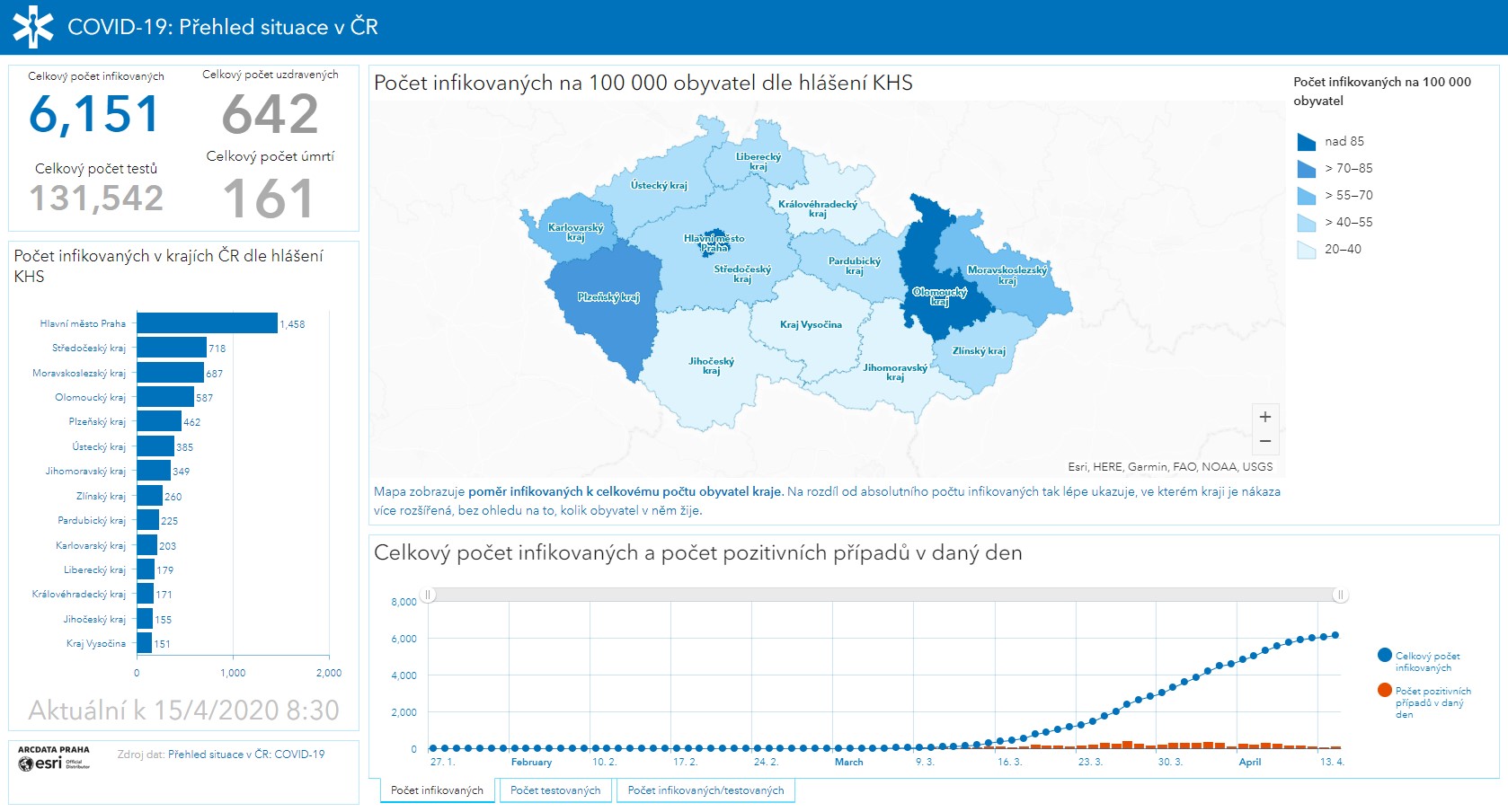
Vzhledem k náročné situaci spojené s šířením onemocnění COVID-19 se společnost Esri rozhodla poskytnout své nástroje a služby GIS pro práci s prostorovými daty. V rámci tohoto výjimečného stavu nabízí Esri půlroční licenci ArcGIS Online a ArcGIS Pro Advanced zdarma. K dispozici jsou také šablony aplikací, které nasazení softwaru ArcGIS usnadní. České zastoupení Esri, společnost ARCDATA PRAHA, připravila stránku s kompletním přehledem dostupných […]
The post Mapy, zdroje a analýzy pro boj s důsledky nákazy COVID-19 od ARCDATA PRAHA appeared first on GISportal.cz.
20200416 - změna úředních hodin
16.4.2020 8:18 ČÚZK /Urady/Katastralni-urady/Katastralni-urady/Katastralni-urad-pro-Ustecky-kraj/O-uradu/Aktuality/20200416-zmena-urednich-hodin20200416 - změna úředních hodin
16.4.2020 8:18 ČÚZK - předpisy a opatření Katastrální úřad pro Ústecký kraj zveřejnil novou aktualitu:S účinností od 20.4.2020 je provedena změna Úředních hodin na pracovištích Katastrálního úřadu pro Ústecký kraj.
Úřední hodiny jsou nově pro všechny agendy:
Pondělí : 8:00 - 17:00
Středa : 8:00 - 17:00
Úprava úředních hodin od 20. 04 .2020
16.4.2020 7:59 ČÚZK /Urady/Katastralni-urady/Katastralni-urady/Katastralni-urad-pro-Olomoucky-kraj/O-uradu/Aktuality/Uprava-urednich-hodin-od-20-04-2020Úprava úředních hodin od 20. 04 .2020
16.4.2020 7:59 ČÚZK - předpisy a opatření Katastrální úřad pro Olomoucký kraj zveřejnil novou aktualitu: Úprava úředních hodin od 20. 04 .2020Změna úředních hodin
16.4.2020 7:35 ČÚZK - předpisy a opatření Katastrální úřad pro Pardubický kraj zveřejnil novou aktualitu: Změna úředních hodin Vážení klienti,na základě Mimořádného opatření MZ jsou úřední hodiny pro podatelny a poskytování údajů z KN na katastrálním pracovišti určeny až do odvolání takto: pondělí a středa od 8:00 – 17:00 hodin. I nadále se upřednostňuje písemný, elektronický nebo telefonický kontakt. Ředitel KÚ Ing. Karel Švarc
Změna úředních hodin
16.4.2020 7:35 ČÚZK - předpisy a opatření Katastrální úřad pro Pardubický kraj zveřejnil novou aktualitu: Změna úředních hodin Vážení klienti,na základě Mimořádného opatření MZ jsou úřední hodiny pro podatelny a poskytování informací na katastrálním pracovišti určeny až do odvolání takto: pondělí a středa od 8:00 – 17:00 hodin. I nadále se upřednostňuje písemný, elektronický nebo telefonický kontakt. Ředitel KÚ Ing. Karel Švarc
Změna úředních hodin
16.4.2020 7:35 ČÚZK /Urady/Katastralni-urady/Katastralni-urady/Katastralni-urad-pro-Pardubicky-kraj/O-uradu/Aktuality/Zmena-urednich-hodinRozšíření úředních hodin
16.4.2020 6:32 ČÚZK - předpisy a opatření Katastrální úřad pro hlavní město Prahu - Katastrální pracoviště Praha zveřejnil novou aktualitu:Rozšíření úředních hodin
Od 1.května 2020 rozšiřujeme úřední hodiny na pondělí a středu od 8 do 17 hodin, úterý a čtvrte od 8 do 14 hodin, pátek od 8 do 15 hodin. I nadále upřednostňujeme bezkontaktní způsob podání (poštou, elektronicky). V případě elektronického podání (elektronickou poštou, datovým schránkami) upozorňujeme na nutnost dodržení stanovených požadavků zde.
Při osobním kontaktu Vás žádáme o dodržování hygienických zásad a respektování pokynů našich zaměstnanců.
Děkujeme za pochopení.
Rozšíření úředních hodin
16.4.2020 6:32 ČÚZK /Urady/Katastralni-urady/Katastralni-urady/Katastralni-urad-pro-hlavni-mesto-Prahu/O-uradu/Aktuality/Rozsireni-urednich-hodinRozšíření úředních hodin
16.4.2020 6:32 ČÚZK - předpisy a opatření Katastrální úřad pro hlavní město Prahu - Katastrální pracoviště Praha zveřejnil novou aktualitu:Rozšíření úředních hodin
Od pondělí 20. dubna 2020 rozšiřujeme úřední hodiny na pondělí a středu od 8 do 17 hodin. I nadále upřednostňujeme bezkontaktní způsob podání (poštou, elektronicky). V případě elektronického podání (elektronickou poštou, datovým schránkami) upozorňujeme na nutnost dodržení stanovených požadavků zde.
Při osobním kontaktu Vás žádáme o dodržování hygienických zásad a respektování pokynů našich zaměstnanců.
Děkujeme za pochopení.
Rozšíření úředních hodin
16.4.2020 6:32 ČÚZK - předpisy a opatření Katastrální úřad pro hlavní město Prahu - Katastrální pracoviště Praha zveřejnil novou aktualitu:Rozšíření úředních hodin
Dobrý den,
od pondělí 20. dubna 2020 rozšiřujeme úřední hodiny na pondělí a středu od 8 do 17 hodin. I nadále upřednostňujeme bezkontaktní způsob podání (poštou, elektronicky). V případě elektronického podání (elektronickou poštou, datovým schránkami) upozorňujeme na nutnost dodržení stanovených požadavků zde.
Při osobním kontaktu Vás žádáme o dodržování hygienických zásad a respektování pokynů našich zaměstnanců.
Děkujeme za pochopení.
Rozšíření úředních hodin
16.4.2020 6:32 ČÚZK - předpisy a opatření Katastrální úřad pro hlavní město Prahu - Katastrální pracoviště Praha zveřejnil novou aktualitu:Rozšíření úředních hodin
Od 20. dubna 2020 rozšiřujeme úřední hodiny na pondělí a středu od 8 do 17 hodin. I nadále upřednostňujeme bezkontaktní způsob podání (poštou, elektronicky). V případě elektronického podání (elektronickou poštou, datovým schránkami) upozorňujeme na nutnost dodržení stanovených požadavků zde.
Při osobním kontaktu Vás žádáme o dodržování hygienických zásad a respektování pokynů našich zaměstnanců.
Děkujeme za pochopení.
Změna úředních hodin podatelny
16.4.2020 6:31 ČÚZK /Urady/Katastralni-urady/Katastralni-urady/Katastralni-urad-pro-Liberecky-kraj/O-uradu/Aktuality/Zmena-urednich-hodin-podatelnyZměna úředních hodin podatelny
16.4.2020 6:31 ČÚZK - předpisy a opatření Katastrální úřad pro Liberecký kraj zveřejnil novou aktualitu: Od 20.4.2020 se prodlužují úřední hodiny pro podatelny a poskytování údajů na pondělí a středa od 8:00 do 17:00 hodin.Změna úředních hodin podatelny
16.4.2020 6:30 ČÚZK /Urady/Katastralni-urady/Katastralni-urady/Katastralni-urad-pro-Liberecky-kraj/Katastralni-pracoviste/KP-Semily/O-uradu/Aktuality/Zmena-urednich-hodin-podatelnyZměna úředních hodin podatelny
16.4.2020 6:30 ČÚZK - předpisy a opatření Katastrální úřad pro Liberecký kraj zveřejnil novou aktualitu: Od 20.4.2020 se prodlužují úřední hodiny pro podatelny a poskytování údajů na pondělí a středa od 8:00 do 17:00 hodin.Změna úředních hodin podatelny
16.4.2020 6:30 ČÚZK - předpisy a opatření Katastrální úřad pro Liberecký kraj zveřejnil novou aktualitu: Od 20.4.2020 se prodlužují úřední hodiny pro podatelny a poskytování údajů na pondělí a středa od 8:00 do 17:00 hodin.Změna úředních hodin podatelny
16.4.2020 6:30 ČÚZK /Urady/Katastralni-urady/Katastralni-urady/Katastralni-urad-pro-Liberecky-kraj/Katastralni-pracoviste/KP-Liberec/O-uradu/Aktuality/Zmena-urednich-hodin-podatelnyZměna úředních hodin podatelny
16.4.2020 6:28 ČÚZK - předpisy a opatření Katastrální úřad pro Liberecký kraj zveřejnil novou aktualitu: Od 20.4.2020 se prodlužují úřední hodiny pro podatelny a poskytování údajů na pondělí a středa od 8:00 do 17:00 hodin.Změna úředních hodin podatelny
16.4.2020 6:28 ČÚZK /Urady/Katastralni-urady/Katastralni-urady/Katastralni-urad-pro-Liberecky-kraj/Katastralni-pracoviste/KP-Jablonec-nad-Nisou/O-uradu/Aktuality/Zmena-urednich-hodin-podatelnyZměna úředních hodin podatelny
16.4.2020 6:25 ČÚZK - předpisy a opatření Katastrální úřad pro Liberecký kraj - Katastrální pracoviště Frýdlantzveřejnil novou aktualitu: Od 4.5.2020 se mění úřední hodiny pro podatelny a poskytování údajů z KN.
Změna úředních hodin podatelny
16.4.2020 6:25 ČÚZK - předpisy a opatření Katastrální úřad pro Liberecký kraj zveřejnil novou aktualitu: Od 20.4.2020 se prodlužují úřední hodiny pro podatelny a poskytování údajů na pondělí a středa od 8:00 do 17:00 hodin.Změna úředních hodin
16.4.2020 6:25 ČÚZK - předpisy a opatření Katastrální úřad pro Liberecký kraj - Katastrální pracoviště Frýdlantzveřejnil novou aktualitu: Od 4.5.2020 se mění úřední hodiny pro podatelny a poskytování údajů z KN.
Změna úředních hodin podatelny
16.4.2020 6:25 ČÚZK /Urady/Katastralni-urady/Katastralni-urady/Katastralni-urad-pro-Liberecky-kraj/Katastralni-pracoviste/KP-Frydlant/O-uradu/Aktuality/Zmena-urednich-hodin-podatelnyZměna úředních hodin
16.4.2020 6:25 ČÚZK /Urady/Katastralni-urady/Katastralni-urady/Katastralni-urad-pro-Liberecky-kraj/Katastralni-pracoviste/KP-Frydlant/O-uradu/Aktuality/Zmena-urednich-hodin-podatelnyZměna úředních hodin podatelny
16.4.2020 6:25 ČÚZK - předpisy a opatření Katastrální úřad pro Liberecký kraj zveřejnil novou aktualitu: Od 20.4.2020 se prodlužují úřední hodiny pro podatelny a poskytování údajů na pondělí a středa od 8:00 do 17:00 hodin.Změna úředních hodin podatelny
16.4.2020 6:25 ČÚZK /Urady/Katastralni-urady/Katastralni-urady/Katastralni-urad-pro-Liberecky-kraj/Katastralni-pracoviste/KP-Ceska-Lipa/O-uradu/Aktuality/Zmena-urednich-hodin-podatelnyZměna úředních hodin podatelny
16.4.2020 6:25 ČÚZK - předpisy a opatření Katastrální úřad pro Liberecký kraj - Katastrální pracoviště Česká Lípa zveřejnil novou aktualitu: Od 20.4.2020 se prodlužují úřední hodiny pro podatelny a poskytování údajů na pondělí a středa od 8:00 do 17:00 hodin.To Support Infrastructure Engineering Ecosystems Working from Home, Bentley Systems Opens Up Full Access to ProjectWise 365 and Waives Subscription Fees through September 30
16.4.2020 0:52 GISCafe.com Webcasts-Webinars Connects Virtual Project Workgroups for Collaboration and Design Review with Purpose-built “Instant-on” Cloud ServiceEXTON, Pa. — …
Woolpert Purchases Additional Leica Geosystems TerrainMapper, Expands Geospatial Bandwidth
15.4.2020 21:45 GISCafe.com Webcasts-Webinars DENVER, April 15, 2020 — (PRNewswire) — Woolpert announced today that it had purchased its fourth Leica Geosystems TerrainMapper, a …Parrot to manufacture its Short-Range Reconnaissance drone prototypes for the Department of Defense in the United States of America
15.4.2020 21:45 GISCafe.com Webcasts-Webinars PARIS, April 15, 2020 — (PRNewswire) — Parrot has passed another milestone in the United States Army's Short-Range Reconnaissance drone …To Support Infrastructure Engineering Ecosystems Working from Home, Bentley Systems Opens Up Full Access to ProjectWise 365 and Waives Subscription Fees through September 30
15.4.2020 21:17 Bentley SystemsConnects Virtual Project Workgroups for Collaboration and Design Review with Purpose-built “Instant-on” Cloud Service
EXTON, PA, USA – April 15, 2020 – Bentley Systems, Incorporated, a leading global provider of comprehensive software and digital twins services for advancing the design, construction, and operations of infrastructure, today announced it has opened up its ProjectWise 365 cloud service, including waiving subscription fees through September 30, 2020, to virtually connect infrastructure project participants forced to work from home.
ProjectWise 365, leveraging Microsoft 365 technology and office productivity tools, extends the reach and accessibility of BIM and infrastructure engineering data to facilitate collaboration and design review across the ecosystem of project stakeholders. As an “instant-on” cloud service accessed through a web browser to simplify design review, transmittals, RFIs, information sharing, and issues resolution, ProjectWise 365 is perfectly suited for quick adoption while working from home, eliminating the need for error-prone combinations of generic technologies such as “drop boxes” and PDF.
In 2019 Bentley Systems was ranked by the ARC Advisory Group as the #1 provider of Collaborative BIM for its enterprise-scalable ProjectWise Design Integration offerings, and Microsoft cited Bentley as one of the top 25 companies in terms of Azure usage globally. In the development of ProjectWise 365, extending infrastructure engineering workflows to all users of Microsoft’s Office 365 cloud services, Bentley leveraged its market-leading experience in meeting the collaboration and work-sharing challenges of distributed project delivery teams.
“The enterprises using ProjectWise Design Integration for work sharing, which include 74 of the ENR Top 100 Design Firms, have been telling us that they credit ProjectWise for sustaining their project productivity over the forced transition to work from home,” said Dustin Parkman, VP, Project Delivery for Bentley. “Now, by broadly and immediately opening up access to our new simplified ProjectWise 365 cloud service, we’re extending ProjectWise advantages in collaboration and design review to infrastructure engineering project teams at every scale. By fully ‘digitally’ enabling every infrastructure professional, we hope to support their resilience in surmounting this crisis.”
Gregory J. Ellwanger, P.E., Project Engineer for BLA, Inc. said, “The present work-from-home conditions and coordination with multiple parties highlight how critical it is to our business and our role as prime consultant on projects, that our project teams always stay connected and productive. ProjectWise 365 cloud services enable us to rapidly deploy a common BIM collaboration environment that avoids the data silos, coordination delays, and the other limitations we’ve experienced while using network drives, file-sharing services, and email. ProjectWise 365 allows us to coordinate designs more quickly and reduce risk in contractual exchanges, regardless of the location of project participants, adding resilience to our design practice and increasing our ability to deliver high-quality projects on schedule.”
Please visit ProjectWise 365 to learn more about the product and visit ProjectWise 365 Offer to learn about this work-from-home offer.
ProjectWise 365 is part of Bentley’s comprehensive effort to help both user organizations and end users to work remotely, providing tools, information, and resources including FAQs, videos, webinars and other technical assets. For more about Bentley’s response to the challenges of working from home, please visit www.bentley.com/en/workingfromhome.
##
About Bentley’s Project Delivery Offerings
Bentley Systems undertakes to provide comprehensive collaboration and constructioneering software, and cloud services, for infrastructure project delivery. ProjectWise 365 cloud services take fullest advantage of Microsoft’s Azure and native web environments. For project digital twins, Bentley’s iTwin Design Review services range from ad hoc 2D/3D discipline-specific workflows through comprehensive and continuous 4D design reviews spanning the full scope of projects utilizing ProjectWise Design Integration. For 4D construction digital twins, Bentley’s SYNCHRO portfolio leverages iTwin services to integrate reality modeling with 4D construction modeling, ConstructSim advanced work packaging, ComplyPro, ProcureWare, and Control and Field cloud services.
Bentley is ranked by ARC Advisory Group as the leading provider of collaborative BIM software. Bentley’s ProjectWise services are the “workhorse for work sharing” for the majority of the ENR Top Design Firms, including 43 of the Top 50. In 2019, Microsoft named Bentley a finalist in the Mixed Reality category of its Partner of the Year program for SYNCHRO’s Microsoft HoloLens 2 use cases.
About Bentley Systems
Bentley Systems is a leading global provider of software solutions to engineers, architects, geospatial professionals, constructors, and owner-operators for the design, construction, and operations of infrastructure. Bentley’s MicroStation-based engineering and BIM applications, and its digital twin cloud services, advance the project delivery (ProjectWise) and the asset performance (AssetWise) of transportation and other public works, utilities, industrial and resources plants, and commercial and institutional facilities.
Bentley Systems employs more than 3,500 colleagues and generates annual revenues of more than $700 million in 172 countries. From inception in 1984, the company has remained majority-owned by its five founding Bentley brothers. www.bentley.com
Bentley, the Bentley logo, AssetWise, ComplyPro, ConstructSim, iTwin, iTwin Design Review, MicroStation, ProcureWare, ProjectWise, ProjectWise Design Integration, and SYNCHRO are either registered or unregistered trademarks or service marks of Bentley Systems, Incorporated or one of its direct or indirect wholly owned subsidiaries. All other brands and product names are trademarks of their respective owners.
To Support Infrastructure Engineering Ecosystems Working from Home, Bentley Systems Opens Up Full Access to ProjectWise 365 and Waives Subscription Fees through September 30
15.4.2020 21:17 Bentley SystemsConnects Virtual Project Workgroups for Collaboration and Design Review with Purpose-built “Instant-on” Cloud Service
EXTON, PA, USA – April 15, 2020 – Bentley Systems, Incorporated, a leading global provider of comprehensive software and digital twins services for advancing the design, construction, and operations of infrastructure, today announced it has opened up its ProjectWise 365 cloud service, including waiving subscription fees through September 30, 2020, to virtually connect infrastructure project participants forced to work from home.
ProjectWise 365, leveraging Microsoft 365 technology and office productivity tools, extends the reach and accessibility of BIM and infrastructure engineering data to facilitate collaboration and design review across the ecosystem of project stakeholders. As an “instant-on” cloud service accessed through a web browser to simplify design review, transmittals, RFIs, information sharing, and issues resolution, ProjectWise 365 is perfectly suited for quick adoption while working from home, eliminating the need for error-prone combinations of generic technologies such as “drop boxes” and PDF.
In 2019 Bentley Systems was ranked by the ARC Advisory Group as the #1 provider of Collaborative BIM for its enterprise-scalable ProjectWise Design Integration offerings, and Microsoft cited Bentley as one of the top 25 companies in terms of Azure usage globally. In the development of ProjectWise 365, extending infrastructure engineering workflows to all users of Microsoft’s Office 365 cloud services, Bentley leveraged its market-leading experience in meeting the collaboration and work-sharing challenges of distributed project delivery teams.
“The enterprises using ProjectWise Design Integration for work sharing, which include 74 of the ENR Top 100 Design Firms, have been telling us that they credit ProjectWise for sustaining their project productivity over the forced transition to work from home,” said Dustin Parkman, VP, Project Delivery for Bentley. “Now, by broadly and immediately opening up access to our new simplified ProjectWise 365 cloud service, we’re extending ProjectWise advantages in collaboration and design review to infrastructure engineering project teams at every scale. By fully ‘digitally’ enabling every infrastructure professional, we hope to support their resilience in surmounting this crisis.”
Gregory J. Ellwanger, P.E., Project Engineer for BLA, Inc. said, “The present work-from-home conditions and coordination with multiple parties highlight how critical it is to our business and our role as prime consultant on projects, that our project teams always stay connected and productive. ProjectWise 365 cloud services enable us to rapidly deploy a common BIM collaboration environment that avoids the data silos, coordination delays, and the other limitations we’ve experienced while using network drives, file-sharing services, and email. ProjectWise 365 allows us to coordinate designs more quickly and reduce risk in contractual exchanges, regardless of the location of project participants, adding resilience to our design practice and increasing our ability to deliver high-quality projects on schedule.”
Please visit ProjectWise 365 to learn more about the product and visit ProjectWise 365 Offer to learn about this work-from-home offer.
ProjectWise 365 is part of Bentley’s comprehensive effort to help both user organizations and end users to work remotely, providing tools, information, and resources including FAQs, videos, webinars and other technical assets. For more about Bentley’s response to the challenges of working from home, please visit www.bentley.com/en/workingfromhome.
ProjectWise Image 1:
Caption:
ProjectWise 365 enables an immersive, web-based 2D/3D hybrid review environment, designed to help teams streamline coordination and resolve issues faster.
##
About Bentley’s Project Delivery Offerings
Bentley Systems undertakes to provide comprehensive collaboration and constructioneering software, and cloud services, for infrastructure project delivery. ProjectWise 365 cloud services take fullest advantage of Microsoft’s Azure and native web environments. For project digital twins, Bentley’s iTwin Design Review services range from ad hoc 2D/3D discipline-specific workflows through comprehensive and continuous 4D design reviews spanning the full scope of projects utilizing ProjectWise Design Integration. For 4D construction digital twins, Bentley’s SYNCHRO portfolio leverages iTwin services to integrate reality modeling with 4D construction modeling, ConstructSim advanced work packaging, ComplyPro, ProcureWare, and Control and Field cloud services.
Bentley is ranked by ARC Advisory Group as the leading provider of collaborative BIM software. Bentley’s ProjectWise services are the “workhorse for work sharing” for the majority of the ENR Top Design Firms, including 43 of the Top 50. In 2019, Microsoft named Bentley a finalist in the Mixed Reality category of its Partner of the Year program for SYNCHRO’s Microsoft HoloLens 2 use cases.
About Bentley Systems
Bentley Systems is a leading global provider of software solutions to engineers, architects, geospatial professionals, constructors, and owner-operators for the design, construction, and operations of infrastructure. Bentley’s MicroStation-based engineering and BIM applications, and its digital twin cloud services, advance the project delivery (ProjectWise) and the asset performance (AssetWise) of transportation and other public works, utilities, industrial and resources plants, and commercial and institutional facilities.
Bentley Systems employs more than 3,500 colleagues and generates annual revenues of more than $700 million in 172 countries. From inception in 1984, the company has remained majority-owned by its five founding Bentley brothers. www.bentley.com
Bentley, the Bentley logo, AssetWise, ComplyPro, ConstructSim, iTwin, iTwin Design Review, MicroStation, ProcureWare, ProjectWise, ProjectWise Design Integration, and SYNCHRO are either registered or unregistered trademarks or service marks of Bentley Systems, Incorporated or one of its direct or indirect wholly owned subsidiaries. All other brands and product names are trademarks of their respective owners.
Compliance testing is now available for implementations of the ‘OGC API - Features - Part 1: Core’ standard
15.4.2020 19:48 GISCafe.com Webcasts-Webinars Products that implement the Standard and pass the tests can now be certified as OGC Compliant.15 April 2020: The Open Geospatial Consortium (OGC) …
CIMON-2 makes its successful debut on the ISS
15.4.2020 19:39 GISCafe.com Webcasts-Webinars Experimental technology for human-machine interaction in the space industry successfully masters the next stage of development in spaceScientific …
Esri Publishes The International Geodesign Collaboration
15.4.2020 18:22 GISCafe.com Webcasts-Webinars New Book Shows How GIS Can Help Experts and Students Work Together to Address the World's Most Urgent ConcernsREDLANDS, Calif. — (BUSINESS …
Pozemkové úpravy ako súčasť zelenej obnovy po korone
15.4.2020 17:40 Komora pozemkových úprav SR
Viac než 180 politikov, biznis lídrov, odborových zväzov, mimovládnych organizácií a think-tankov podpísalo výzvu, aby Európska zelená dohoda zohrávala kľúčovú úlohu pri rekonštruovaní ekonomiky Európy po COVID-19 kríze
AgEagle Receives Follow-On Purchase Orders to Manufacture Commercial Drones for Package Delivery
15.4.2020 16:56 GISCafe.com Webcasts-Webinars NEODESHA, Kan., April 15, 2020 (GLOBE NEWSWIRE) -- AgEagle Aerial Systems Inc. (NYSE American: UAVS) (“AgEagle” or the “Company”), an …Kratos Awarded Sole-Source Contracts for 21 High-Performance Jet Drones, Spares, and Support Totaling Over $19,000,000
15.4.2020 16:56 GISCafe.com Webcasts-Webinars SAN DIEGO, April 15, 2020 (GLOBE NEWSWIRE) -- Kratos Defense & Security Solutions, Inc. (NASDAQ:KTOS), a leading National Security Solutions …TomTom Expands Mapping Deal with Verizon by Providing Maps APIs and SDKs
15.4.2020 16:55 GISCafe.com Webcasts-Webinars AMSTERDAM, April 15, 2020 (GLOBE NEWSWIRE) -- TomTom [TOM2], the location technology specialist, today announced that Verizon will integrate …Velodyne Lidar Launches Ecosystem Partner Program
15.4.2020 16:55 GISCafe.com Webcasts-Webinars “Automated with Velodyne” Aims to Propel Customer SuccessSAN JOSE, Calif. — (BUSINESS WIRE) — April 15, 2020 —
Velodyne …
Worldwide Services Market Momentum Derailed by COVID-19 Pandemic, According to IDC
15.4.2020 16:55 GISCafe.com Webcasts-Webinars FRAMINGHAM, Mass. — (BUSINESS WIRE) — April 15, 2020 —Worldwide IT Services and Business Services revenue grew 5% year over year …
Dynata Introduces Interactive Global COVID-19 Symptom Map to Help Predict Potential "Hot Spots" of Coronavirus Outbreak
15.4.2020 16:55 GISCafe.com Webcasts-Webinars Publicly-available global database leverages the reach of 62 million panelists to identify progression of common symptoms associated with COVID-19 …TeamViewer Pilot Among First Apps to Use New iPad Pro LiDAR Scanner
15.4.2020 16:55 GISCafe.com Webcasts-Webinars AR functionality enables remote experts to guide field service workers performing complex tasks with precision using new iPad ProTAMPA, Fla., April …
Cherre and Spatial.ai Announce Partnership to Integrate Geosocial Data Into Real Estate Data Platform
15.4.2020 16:55 GISCafe.com Webcasts-Webinars This partnership will enable mutual customers to layer billions of social media data points on top of real estate data for actionable insightsNEW …
Geospark Analytics Data and Risk Assessment Models are now Live in the Esri ArcGIS Marketplace
15.4.2020 16:55 GISCafe.com Webcasts-Webinars HERNDON, Va., April 15, 2020 — (PRNewswire) — Geospark Analytics, a world class leader in developing applied artificial …Inpixon Wins Contract to Supply Indoor Mapping Platform for Dozens of Shopping Centers in Europe and Asia
15.4.2020 16:55 GISCafe.com Webcasts-Webinars PALO ALTO, Calif. and TORONTO, April 15, 2020 — (PRNewswire) — Inpixon (Nasdaq: INPX), a leading indoor data company that …Pravidlá prevádzky spoločnosti Geotronics Slovakia, s.r.o.
15.4.2020 14:25 Geotronics.skV reakcii na situáciu okolo vírusu na COVID-19 sme prispôsobili pravidlá predaja a prevádzky spoločnosti Geotronics Slovakia, s.r.o. tak, aby boli dodržané všetky usmernenia Úradu verejného zdravotníctva a aby sa zabezpečila čo najvyššia ochrana našich zákazníkov a našich zamestnancov. 1. Vstup do priestorov: pred návštevou našej spoločnosti je vhodné, aby ste nás vopred kontaktovali a […]
Príspevok Pravidlá prevádzky spoločnosti Geotronics Slovakia, s.r.o. zobrazený najskôr Geotronics Slovakia.
Rozpočet úřadu za rok 2016
15.4.2020 13:24 ČÚZK /Urady/Zememericky-urad/Rozpocty/Rozpocet-uradu-za-rok-2016Rozpočet úřadu za rok 2016
15.4.2020 13:24 Zeměměřický úřad Zeměměřický úřadvystavuje rozpočet úřadu za rok
2016
Rozpočet úřadu za rok 2016
15.4.2020 13:24 ČÚZK - předpisy a opatření Zeměměřický úřadvystavuje rozpočet úřadu za rok
2016
20200415 - uzamčení volebních okrsků
15.4.2020 13:23 ČÚZK - předpisy a opatření Rozhodnutím prezidenta republiky byly vyhlášeny podzimní volby 2020 do Senátu Parlamentu České republiky a volby do zastupitelstev krajů, což bylo zveřejněno ve Sbírce zákonů dne 15. 4. 2020 (předpis č. 169/2020). Od vyhlášení voleb do vyhlášení celkových výsledků voleb Státní volební komisí jsou Ministerstvem vnitra uzamčeny volební okrsky, a proto nyní nelze měnit vymezení volebních okrsků v RÚIAN.20200415 - uzamčení volebních okrsků
15.4.2020 13:23 ČÚZK - předpisy a opatření Rozhodnutím prezidenta republiky byly vyhlášeny podzimní volby 2020 do Senátu Parlamentu České republiky a volby do zastupitelstev krajů, což bylo zveřejněno ve Sbírce zákonů dne 15. 4. 2020 (předpis č. 169/2020). Od vyhlášení voleb do vyhlášení celkových výsledků voleb Státní volební komisí jsou uzamčeny volební okrsky, a proto nyní nelze měnit vymezení volebních okrsků v RÚIAN.20200415 - uzamčení volebních okrsků
15.4.2020 13:23 ČÚZK /Uvod/Produkty-a-sluzby/RUIAN/Volebni-okrsky-v-RUIAN/Archiv-novinky/20191016-Odstavka-systemu20200415 - uzamčení volebních okrsků
15.4.2020 13:14 ČÚZK - předpisy a opatření Rozhodnutím prezidenta republiky byly vyhlášeny podzimní volby 2020 do Senátu Parlamentu České republiky a volby do zastupitelstev krajů, což bylo zveřejněno ve Sbírce zákonů dne 15. 4. 2020 (předpis č. 169/2020). Od vyhlášení voleb do vyhlášení celkových výsledků voleb Státní volební komisí jsou uzamčeny volební okrsky, a proto nyní nelze měnit vymezení volebních okrsků v RÚIAN.20200415 - uzamčení volebních okrsků
15.4.2020 13:14 ČÚZK - předpisy a opatření Rozhodnutím prezidenta republiky byly vyhlášeny podzimní volby 2020 do Senátu Parlamentu České republiky a volby do zastupitelstev krajů, což bylo zveřejněno ve Sbírce zákonů dne 15. 4. 2020 (předpis č. 169/2020). Od vyhlášení voleb do vyhlášení celkových výsledků voleb Státní volební komisí jsou Ministerstvem vnitra uzamčeny volební okrsky, a proto nyní nelze měnit vymezení volebních okrsků v RÚIAN.20200512 - Pozastavení organizace školení ISÚI
15.4.2020 13:14 ČÚZK - předpisy a opatření Vzhledem k současným vládním opatřením v souvislosti s pandemií COVID-19 bude možné praktická školení ISÚI a semináře RÚIAN zorganizovat nejdříve v 09/2020.20200415 - uzamčení volebních okrsků
15.4.2020 13:14 ČÚZK /Uvod/Produkty-a-sluzby/RUIAN/RUIAN-novinky/2020/20191016-Odstavka-systemu20200512 - Pozastavení organizace školení ISÚI
15.4.2020 13:14 ČÚZK /Uvod/Produkty-a-sluzby/RUIAN/RUIAN-novinky/2020/20191016-Odstavka-systemuAktuality pracoviště
15.4.2020 13:03 ČÚZK - předpisy a opatření Katastrální úřad pro Vysočinu - Katastrální pracoviště Velké Meziříčí zveřejnil novou aktualitu: V souladu s usnesením vlády č. 396 o prodloužení nouzového stavu ze dne 9. dubna 2020 jsou úřední hodiny pro veřejnost pouze v pondělí a středu od 8,00 do 17,00 hod., v tyto úřední hodiny lze rovněž vhodit podání v zalepené obálce do uzavřené schránky, která je umístěna v přízemí budovy katastrálního pracoviště.Schránka je zpřístupněna v neúředních dnech od 6,00 do 8,00 hod a v úředních dnech od 6,00 do 17,00 hod
Pokud bude v podání uvedena e-mailová adresa, bude na ni zasláno potvrzení o přijetí podání. V případě, že je s podáním spojena poplatková povinnost, bude účastníkům zaslána i výzva k úhradě správního poplatku převodem na účet. Děkujeme, že budete v co největší míře využívat této zcela bezkontaktní možnosti.
Aktuality pracoviště
15.4.2020 13:03 ČÚZK /Urady/Katastralni-urady/Katastralni-urady/Katastralni-urad-pro-Vysocinu/Katastralni-pracoviste/KP-Velke-Mezirici/O-uradu/Aktuality/Aktuality-pracoviste-(1)Seminář: Imagery Deep Learning Made Easy
15.4.2020 10:30 ARCDATAMetody strojového učení nám usnadnily práci s obrazovými daty. Urychlily čas, který počítače potřebují k identifikaci objektů na snímku i ke klasifikaci pixelů. Využití nacházejí v mnoha oborech – při automatizované tvorbě map, mapování následků přírodních katastrof, sčítání stromů v lese, sledování změny land-use či při identifikaci prvků na snímcích a full-motion videu z dronu.
Webový seminář Esri Imagery Deep Learning Made Easy vás provede nástroji pro strojové a hloubkové učení (machine learning, deep learning), které naleznete v systému ArcGIS. Proběhne v úterý 21. dubna od 18.00.
Obsahem tohoto semináře bude:
- úvod do AI, strojového a hloubkového učení,
- příprava a označení dat pro hloubkové učení,
- trénování a učení modelů,
- integrace s frameworky pro hloubkové učení,
- nastavení pracovních postupů pro hloubkové učení,
- integrace s ArcGIS Full Motion Video (FMV),
- příklady a ukázky nasazení z různých oborů,
- tipy pro snadný start,
- užitečné zdroje.
Seminář bude veden v anglickém jazyce. Nezávazně se na něj můžete registrovat na stránce https://register.gotowebinar.com/register/586502998004657932

Seminář: Imagery Deep Learning Made Easy
15.4.2020 10:30 ARCDATAAktualizace: Seminář je již plně obsazený. Situaci budeme sledovat, a pokud se zvýší kapacita nebo se vypíše nový termín, budeme informovat.
Metody strojového učení nám usnadnily práci s obrazovými daty. Urychlily čas, který počítače potřebují k identifikaci objektů na snímku i ke klasifikaci pixelů. Využití nacházejí v mnoha oborech – při automatizované tvorbě map, mapování následků přírodních katastrof, sčítání stromů v lese, sledování změny land-use či při identifikaci prvků na snímcích a full-motion videu z dronu.
Webový seminář Esri Imagery Deep Learning Made Easy vás provede nástroji pro strojové a hloubkové učení (machine learning, deep learning), které naleznete v systému ArcGIS. Proběhne v úterý 21. dubna od 18.00.
Obsahem tohoto semináře bude:
- úvod do AI, strojového a hloubkového učení,
- příprava a označení dat pro hloubkové učení,
- trénování a učení modelů,
- integrace s frameworky pro hloubkové učení,
- nastavení pracovních postupů pro hloubkové učení,
- integrace s ArcGIS Full Motion Video (FMV),
- příklady a ukázky nasazení z různých oborů,
- tipy pro snadný start,
- užitečné zdroje.
Seminář bude veden v anglickém jazyce. Nezávazně se na něj můžete registrovat na stránce https://register.gotowebinar.com/register/586502998004657932