


![]()

zprávy
zdroje zpráv:Montevideo, Uruguay
17.4.2020 10:00 ESA Observing the Earth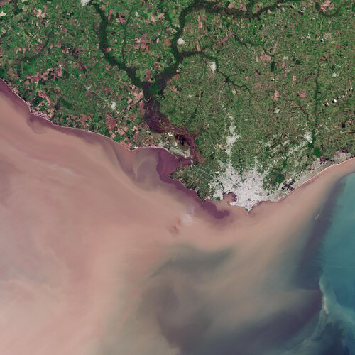 Image:
The Copernicus Sentinel-2 mission takes us over Montevideo – the capital and largest city of Uruguay.
Image:
The Copernicus Sentinel-2 mission takes us over Montevideo – the capital and largest city of Uruguay.
Earth from Space: Montevideo
17.4.2020 10:00 ESA Observing the Earth Video:
00:02:39
Video:
00:02:39
In this week's edition of the Earth from Space programme, the Copernicus Sentinel-2 mission takes us over Montevideo – the capital and largest city of Uruguay.
See also Montevideo, Uruguay to download the image.
Rozšíření úředních hodin
17.4.2020 9:58 ČÚZK - předpisy a opatření Český úřad zeměměřický a katastrální zveřejnil novou aktualitu: Katastrální úřad pro Středočeský kraj, Katastrální pracoviště Rakovník oznamuje, že s účinností ode dne 20. dubna 2020 rozšiřuje úřední hodiny takto:ÚŘEDNÍ HODINY (PODATELNY A INFORMACE Z KATASTRU):
PONDĚLÍ 8-17 hod
STŘEDA 8-17 hod
Rozšíření úředních hodin
17.4.2020 9:58 ČÚZK /Urady/Katastralni-urady/Katastralni-urady/Katastralni-urad-pro-Stredocesky-kraj/Katastralni-pracoviste/KP-Rakovnik/O-uradu/Aktuality/Rozsireni-urednich-hodinTextron to Hold Annual Shareholders Meeting Virtually
17.4.2020 9:00 GISCafe.com Webcasts-Webinars PROVIDENCE, R.I. — (BUSINESS WIRE) — April 13, 2020 — Textron Inc. (NYSE: TXT) will hold its 2020 Annual Meeting of Shareholders …Orbit Logic Tackles Autonomous Planning of Martian Swarms
17.4.2020 9:00 GISCafe.com Webcasts-Webinars GREENBELT, MD (April 16th, 2020) – Orbit Logic has been awarded a Phase I Small Business Technology Transfer (STTR) contract sponsored by the …20200417 - Rozšíření úředních hodin pro veřejnost
17.4.2020 8:58 ČÚZK /Aktuality-resort/2020/20200417-Rozsireni-urednich-hodin-pro-verejnost20200417 - Rozšíření úředních hodin pro veřejnost
17.4.2020 8:58 ČÚZK - předpisy a opatření Český úřad zeměměřický a katastrální zveřejnil novou aktualitu: Důležité upozornění!S účinností od 20. dubna 2020 dochází na katastrálních pracovištích k rozšíření úředních hodin pro veřejnost. Bližší informace o úředních hodinách konkrétního katastrálního pracoviště je možné získat na jeho internetových stránkách (stránky katastrálních úřadů). Žádáme návštěvníky, aby využívali rozšířené úřední hodiny v plném rozsahu a pomohli tím minimalizovat počet současně čekajících klientů.
Aplikace AMG COVID-19
17.4.2020 8:58 GISportal.cz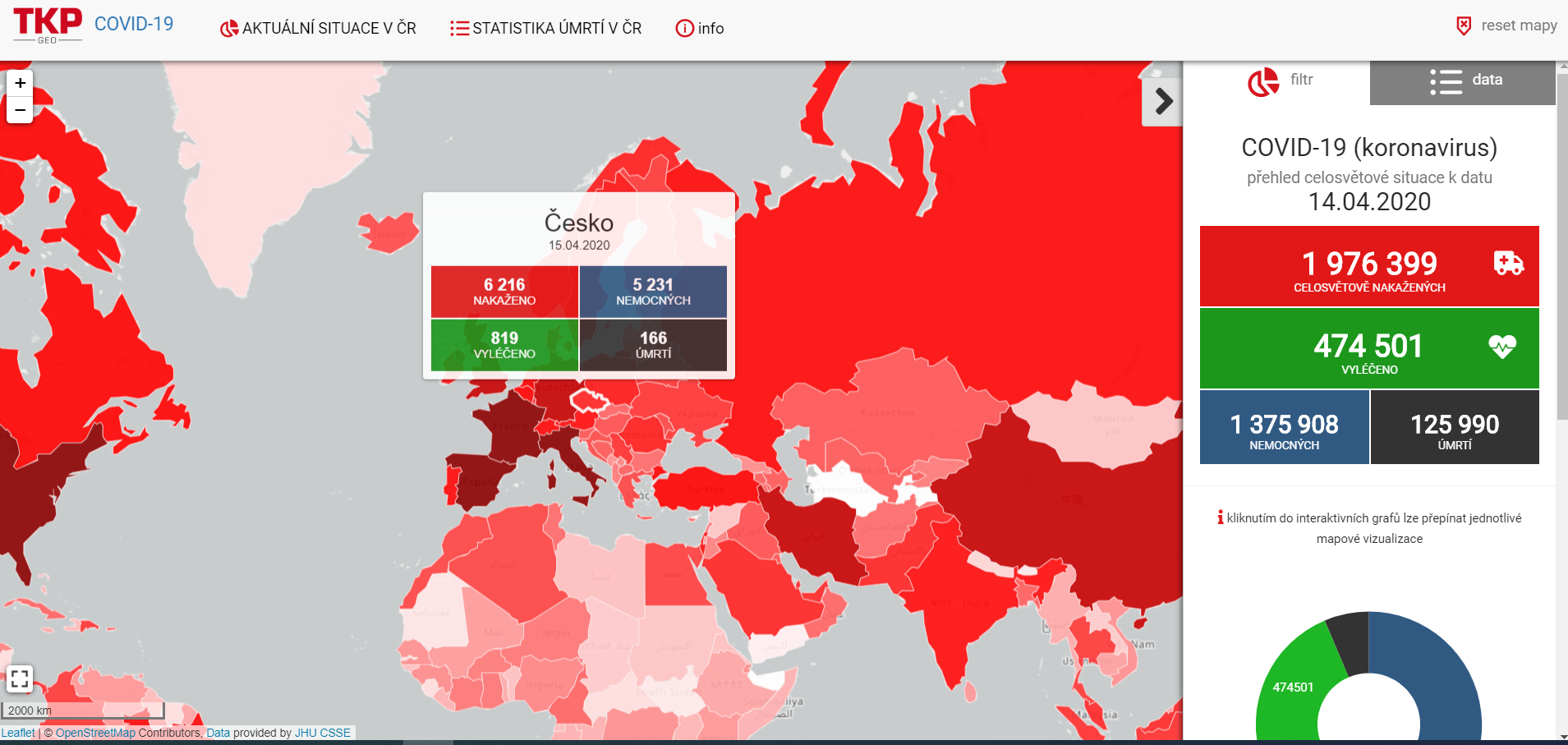
Již několik českých firem, či univerzit vytvořilo stránky, na kterých kombinují různé mapové výstupy, dashboardy či RSS čtečky o současné epidemii Covid-19. Další firmou, která představila své řešení je TKP Geo se svoji aplikací AMG COVID-19. Co všechno AMG COVID–19 umí? Aplikace a její ovládání je intuitivní, a zvládá i že běžné funkcionality typu filtrování […]
The post Aplikace AMG COVID-19 appeared first on GISportal.cz.
Společnost TKP geo uvádí Covid-19 v souvislostech ve své aplikaci AMG
17.4.2020 8:51 ZeměměřičSpolečnost TKP geo představila svoji vizualizační aplikaci AMG COVID-19. COVID-19 (z anglického spojení coronavirus disease 2019) je infekční onemocnění, které je způsobeno novým koronavirem SARS-CoV-2 (dříve označovaným jako 2019-nCoV), jenž se začal šířit v prosinci 2019 z čínského města Wu-chan. Označení COVID-19 bylo Světovou zdravotnickou organizací prohlášeno za oficiální dne 11. února 2020. Aplikace AMG Covid-19 obsahuje přehled celosvětové […]
The post Společnost TKP geo uvádí Covid-19 v souvislostech ve své aplikaci AMG appeared first on Zeměměřič.
20200417 Rada / odborný rada oddělení právních vztahů k nemovitostem
17.4.2020 8:45 ČÚZK /Urady/Katastralni-urady/Katastralni-urady/Katastralni-urad-pro-Stredocesky-kraj/Katastralni-pracoviste/KP-Beroun/O-uradu/Aktuality/20190828-Odborny-rada-oddeleni-pravnich-vztahu-(1)20200417 Rada / odborný rada oddělení právních vztahů k nemovitostem
17.4.2020 8:45 ČÚZK - předpisy a opatření Katastrální úřad pro Středočeský kraj - Katastrální pracoviště Beroun Vyhlášení výběrového řízení: Rada / odborný rada oddělení právních vztahů k nemovitostem V části "Úřední deska", v sekci "Oznámení a jiná úřední sdělení" bylo vystaveno "Oznámení o vyhlášení výběrového řízení na obsazení služebního místa Rada / odborný rada oddělení právních vztahů k nemovitostem "Rada / odborný rada oddělení právních vztahů k nemovitostem
17.4.2020 8:44 ČÚZK - volná místa Katastrální úřad pro Středočeský kraj - Katastrální pracoviště Beroun vypisuje výběrové řízení na místo Rada / odborný rada oddělení právních vztahů k nemovitostemRada / odborný rada oddělení právních vztahů k nemovitostem
17.4.2020 8:44 ČÚZK - předpisy a opatření Katastrální úřad pro Středočeský kraj - Katastrální pracoviště Berounvypisuje výběrové řízení na místo Rada / odborný rada oddělení právních vztahů k nemovitostem
Rada / odborný rada oddělení právních vztahů k nemovitostem
Rada / odborný rada oddělení právních vztahů k nemovitostem
17.4.2020 8:44 ČÚZK /Urady/Katastralni-urady/Katastralni-urady/Katastralni-urad-pro-Stredocesky-kraj/Uredni-deska/Oznameni-a-jina-uredni-sdeleni/Volna-mista/Rada-odborny-rada-oddeleni-pravnich-vztahu-k-n-(5)20200417 Odborný / vrchní referent oddělení právních vztahů k nemovitostem
17.4.2020 8:13 ČÚZK /Urady/Katastralni-urady/Katastralni-urady/Katastralni-urad-pro-Stredocesky-kraj/Katastralni-pracoviste/KP-Pribram/O-uradu/Aktuality/20190828-Odborny-rada-oddeleni-pravnich-vztahu-(1)20200417 Odborný / vrchní referent oddělení právních vztahů k nemovitostem
17.4.2020 8:13 ČÚZK - předpisy a opatření Katastrální úřad pro Středočeský kraj - Katastrální pracoviště Příbram Vyhlášení výběrového řízení: Odborný / vrchní referent oddělení právních vztahů k nemovitostem V části "Úřední deska", v sekci "Oznámení a jiná úřední sdělení" bylo vystaveno "Oznámení o vyhlášení výběrového řízení na obsazení služebního místa Odborný / vrchní referent oddělení právních vztahů k nemovitostem "Odborný / vrchní referent oddělení právních vztahů k nemovitostem
17.4.2020 8:12 ČÚZK - předpisy a opatření Katastrální úřad pro Středočeský kraj - Katastrální pracoviště Příbramvypisuje výběrové řízení na místo Odborný / vrchní referent oddělení právních vztahů k nemovitostem
Odborný / vrchní referent oddělení právních vztahů k nemovitostem
Odborný / vrchní referent oddělení právních vztahů k nemovitostem
17.4.2020 8:12 ČÚZK /Urady/Katastralni-urady/Katastralni-urady/Katastralni-urad-pro-Stredocesky-kraj/Uredni-deska/Oznameni-a-jina-uredni-sdeleni/Volna-mista/Odborny-vrchni-referent-oddeleni-pravnich-vztahuOdborný / vrchní referent oddělení právních vztahů k nemovitostem
17.4.2020 8:12 ČÚZK - volná místa Katastrální úřad pro Středočeský kraj - Katastrální pracoviště Příbram vypisuje výběrové řízení na místo Odborný / vrchní referent oddělení právních vztahů k nemovitostemINSPIRE téma Budovy (BU)
17.4.2020 2:00 Cenia - Katalog metadat ČR - INSPIRE Data odpovídají směrnici INSPIRE pro téma budovy (BU). Data pochází částečně z projektu RÚIAN (Registr územní identifikace, adres a nemovitostí), který je součástí základních registrů České Republiky a obsahuje informace o územní identifikaci, adresách a nemovitostech, a částečně z ISKN (Informační systém katastru nemovistostí). Zdrojem informací o budovách v ISKN je objekt Stavba, v RÚIAN je to Stavební objekt. Většina Staveb je zároveň Stavebními objekty, ale jsou případy, kdy tomu tak není. Kromě Budov datová sada obsahuje i části budov, které jsou pro potřeby INSPIRE vyjádřeny vchody z RÚIAN. Vchody obsahují informace o počtu podlaží, technickoekonomických atributech apod. Datová sada pokrývá celé území české republiky. V datové sadě není uvedeno 1,14%, t.j. 48334 budov (k 13. 04. 2020), protože neobsahují definiční bod ani polygon. Více v zákoně č. 111/2009 Sb., o základních registrech, ve vyhlášce č. 359/2011 Sb., o základním registru územní identifikace, adres a nemovitostí v platných zněních, v zákoně 256/2013 Sb., o katastru nemovitostí, v katastrální vyhlášce č. 357/2013 Sb. v platném znění a INSPIRE Data Specification on Buildings v 3.0 z 13.12.2013. Data ve formátu GML 3.2.1 jsou validní proti schématu XML pro INSPIRE téma Budovy ve verzi 4.0 a proti schématu pro prostorová data ELF ve verzi 1.0.Katastrální mapa ve formátech DGN a DXF poskytovaná v e-shopu
17.4.2020 2:00 Cenia - Katalog metadat ČR - INSPIRE Katastrální mapa je závazným státním mapovým dílem velkého měřítka, obsahuje body polohového bodového pole, polohopis a popis. Katastrální mapa ve vektorové podobě je poskytována zdarma ve formátu DGN a DXF a obsahuje prvky Digitální katastrální mapy (DKM) a Katastrální mapy digitalizované (KMD), tedy bodová pole, budovy, další prvky mapy, hranice parcel, katastrální hranice, parcely katastru nemovitostí, prvky orientační mapy a hranice věcného břemene. Z důvodu použití formátu DGN produkt neobsahuje značky na liniích a oblouky jsou nahrazeny lomenými čárami. Katastrální mapa ve vektorové podobě k 13. 04. 2020 pokrývá 96,75% území České republiky, t.j. 76 302,41km2. Více katastrální vyhláška č.357/2013 Sb. v platném znění.Katastrální mapa v rastrové podobě poskytovaná v e-shopu
17.4.2020 2:00 Cenia - Katalog metadat ČR - INSPIRE Katastrální mapa v rastrové podobě je poskytována za úplatu a obsahuje analogovou mapu s kompletní kresbou. Analogová mapa pokrývá 3,02 % území České republiky, což je 2 381,17km2. Více katastrální vyhláška č.357/2013 Sb. v platném znění.INSPIRE téma Adresy (AD)
17.4.2020 2:00 Cenia - Katalog metadat ČR - INSPIRE Data odpovídají směrnici INSPIRE pro téma adresy (AD). Vychází především z projektu RÚIAN (Registr územní identifikace, adres a nemovitostí), který je součástí základních registrů České Republiky a obsahuje informace o územní identifikaci, adresách a nemovitostech. Data publikovaná v rámci INSPIRE obsahují pouze adresní místa a jejich komponenty, kterými jsou stát, obec, část obce, městský obvod v Praze (MOP), městký obvod/městská část (MO/MČ), ulice a pošta a to na území celé České Republiky. Obsahují rozvněž geometrii, která určuje definiční bod adresního místa. V datové sadě nění uvedeno 1,17%, t.j. 34465 adresních míst (k 13. 04. 2020), protože neobsahují definiční bod, podle kterého by je bylo možné prostorově určit. Více v zákoně č. 111/2009 Sb., o základních registrech a ve vyhlášce č. 359/2011 Sb., o základním registru územní identifikace, adres a nemovitostí v platných zněních a INSPIRE Data Specification on Addresses v 3.0.1 z 26.4.2010. Data ve formátu GML 3.2.1 jsou validní proti schématu XML pro INSPIRE téma Adresy ve verzi 4.0 a proti schématu pro prostorová data ELF ve verzi 1.0.INSPIRE téma Parcely (CP)
17.4.2020 2:00 Cenia - Katalog metadat ČR - INSPIRE Data odpovídají směrnici INSPIRE pro téma katastrální parcely (CP). Vychází z katastrální mapy, která je závazným státním mapovým dílem velkého měřítka, obsahuje body polohového bodového pole, polohopis a popis a může mít formu digitální mapy, analogové mapy nebo digitalizované mapy. Data publikovaná v rámci INSPIRE obsahují pouze katastrální území (pro celou Českou Republiku) a parcely a jejich hranice z území, kde je digitální mapa (k 13. 04. 2020 je to 96,75% území České republiky, t.j. 76 302,41km2). Více katastrální zákon 344/1992 SB., katastrální vyhláška č.26/2007 Sb. v platném znění a INSPIRE Data Specification on Cadastral Parcels v 3.0.1. Data ve formátu GML 3.2.1 jsou validní proti schématu XML pro INSPIRE téma Parcely ve verzi 4.0 a proti schématu pro prostorová data ELF ve verzi 1.0.INSPIRE téma Rozšířené Parcely (CPX)
17.4.2020 2:00 Cenia - Katalog metadat ČR - INSPIRE Rozšíření má za cíl poskytovat katastrální mapu s obsahem podle vyhlášky ve vektorové podobě ve struktuře plně v souladu se strukturou danou směrnicí INSPIRE. Data rozšiřují směrnici INSPIRE pro téma katastrální parcely (CP) o věcná břemena, geodetické body, další prvky mapy, původní obloukovou geometrii a o parcely určené definičním bodem (ty pouze v oblastech s analogovou mapou). Vychází z katastrální mapy, která je závazným státním mapovým dílem velkého měřítka, obsahuje body polohového bodového pole, polohopis a popis a může mít formu digitální mapy, analogové mapy nebo digitalizované mapy. Publikovaná data obsahují katastrální území pro celou Českou Republiku, parcely a jejich hranice, věcná břemena, další prvky mapy a původní obloukovou geometrii z území, kde je digitální mapa (k 13. 04. 2020 je to 96,75% území České republiky, t.j. 76 302,41km2) a ve zbytku území katastrální parcely určené pouze definičním bodem (tedy bez hranic a polygonu). Katastrální parcely a hranice obsahují oproti datové sadě INSPIRE některé atributy navíc. Jedná se o typ hranice, způsob využití území, druh pozemku, vazbu na budovu a o mapové značky. Více katastrální zákon 344/1992 SB., katastrální vyhláška č.26/2007 Sb. v platném znění a INSPIRE Data Specification on Cadastral Parcels v 3.0.1. Data ve formátu GML 3.2.1 jsou validní proti schématu XML pro Rozšířené Parcely (CPX) ve verzi 4.0.Intermap Announces Key Software Subscriptions
17.4.2020 0:45 GISCafe.com Webcasts-Webinars DENVER, April 16, 2020 — (PRNewswire) — Intermap Technologies ("Intermap" or the "Company"), a global leader in geospatial intelligence …Od pondělí 20. dubna je ukončen nouzový režim chodu úřadu. Nadále je však nutné dodržovat bezpečnostní opatření
17.4.2020 0:00 Státní pozemkový úřad Praha, 17. dubna 2020: Od pondělí 20. dubna jsou na všech pracovištích Státního pozemkového úřadu (SPÚ) obnoveny úřední hodiny v pondělí a ve středu od 8 do 17 hodin. Stejné úřední hodiny jsou do odvolání stanoveny i pro podatelny SPÚ. V ostatní pracovní dny budou pracoviště pro veřejnost uzavřena, zajištěno je poradenství pomocí elektronické komunikace, a to v době od 8,30 do 14 hodin. Nadále je třeba dodržovat nařízení vlády i další bezpečnostní pravidla.Oznámení o omezeném provozu katastrálních pracovišť:
16.4.2020 21:20 ČÚZK - předpisy a opatření Katastrální úřad pro Jihočeský kraj zveřejnil novou aktualitu: Oznámení o omezeném provozu katastrálních pracovišť:S účinností ode dne 20. dubna 2020 platí pro všechna katastrální pracoviště v územní působnosti Katastrálního úřadu pro Jihočeský kraj úřední hodiny pro veřejnost:
pondělí 8.00 – 17.00 hodin
středa 8.00 – 17.00 hodin
V rámci těchto úředních hodin jsou přijímána veškerá podání včetně návrhů na vklad do katastru nemovitostí a v omezené míře poskytovány informace z katastru (upřednostňuje se jejich získání prostřednictvím aplikace Nahlížení do KN). Veškeré platby je možno učinit pouze platební kartou nebo bezhotovostně převodem z účtu.
Nad rámec výše uvedených úředních hodin lze podání vůči katastrálnímu úřadu učinit i bezkontaktně, a to prostřednictvím provozovatele poštovních služeb, elektronicky nebo prostřednictvím sběrného boxu, který je umístěn v blízkosti vstupu do budovy příslušného katastrálního pracoviště (v případě KP Písek ve 3. patře budovy).
Obecné informace : tel. 386 713 111
Informace k probíhajícím řízením:
KP České Budějovice tel. 386 713 299
KP Český Krumlov tel. 380 301 841
KP Jindřichův Hradec tel. 384 370 140
KP Písek tel. 382 206 811
KP Prachatice tel. 388 302 331
KP Strakonice tel. 383 313 161
KP Tábor tel. 381 203 011
Oznámení o omezeném provozu katastrálních pracovišť:
16.4.2020 21:20 ČÚZK /Urady/Katastralni-urady/Katastralni-urady/Katastralni-urad-pro-Jihocesky-kraj/O-uradu/Aktuality/Oznameni-o-omezenem-provozu-katastralnich-pracovisFortem Technologies Announces Shipment of New DroneHunter F700 - World's Only Radar-Based Autonomous Interceptor Drone For Tracking and Stopping Dangerous Drones
16.4.2020 17:50 GISCafe.com Webcasts-Webinars PLEASANT GROVE, Utah, April 16, 2020 — (PRNewswire) — Fortem Technologies, Inc., a market leader of counter-drone security and …Advan Research Launches Interactive Map of Global Foot-Traffic Hot Spots
16.4.2020 17:50 GISCafe.com Webcasts-Webinars NEW YORK, April 16, 2020 (GLOBE NEWSWIRE) -- Advan Research, a leading geolocation data provider, has developed a new and easy way to view …Citadel Defense Launches New AI Software that Detects and Defeats Air, Land, and Sea Drones
16.4.2020 17:50 GISCafe.com Webcasts-Webinars Titan’s AI and adaptive countermeasures address full spectrum operationsSAN DIEGO — (BUSINESS WIRE) — April 16, 2020 —
Citadel …
PicPocket-Labs, Inc. awarded patent to request, dispatch and navigate drones to/within a geofence and semi-/autonomous media/data collection in same
16.4.2020 17:50 GISCafe.com Webcasts-Webinars Drone-on-Demand patent expands the utility of PicPocket-Labs' core, geofencing IP to all manners of UAV/UAM applications in Enterprise, Government …Mapping Chernobyl fires from space
16.4.2020 17:00 ESA Observing the Earth
With an outbreak of wildfires recently threatening the closed Chernobyl nuclear power plant in the Ukraine, the Copernicus Emergency Mapping Service has been activated and the Copernicus Sentinel-2 satellite mission has imaged the fires and smoke, and mapped the resulting area of burned ground.
I letos vás tradičně zv
16.4.2020 15:58 Adeon![]() I letos vás tradičně zveme na pravidelnou roadshow strojírenských technologií CAD produktů.
I letos vás tradičně zveme na pravidelnou roadshow strojírenských technologií CAD produktů.
Online kurz Cartography. začíná už příští týden
16.4.2020 15:50 ARCDATAChcete si zlepšit svoje dovednosti při tvorbě map, dozvědět se praktické tipy a návody a vyzkoušet si, co jste se naučili, při několika zajímavých úlohách? Společnost Esri znovu pořádá online kurz Cartography., kterým vás provedou kartografové Kenneth Field, John Nelson, Wesley Jones a Edie Punt.
Co bude například na programu?
- Základy tvorby map (Úvod do práce v ArcGIS Pro, výkresy, měřítkové závislé symboly, mimorámové údaje).
- Úvod do matematické kartografie (kartografická zobrazení, transformace, publikace map v nestandardních zobrazeních).
- Grafické možnosti (tematické mapy, kartogramy, generalizace, speciální postupy).
- Popisky a kompozice mapy.
- Využití 3D.
- Mapování pohybu a změny – jak v mapě vyjádřit čas? (animace).
Po dobu trvání kurzu budou mít účastníci přístup k ArcGIS Pro a na ArcGIS Online. Jedna lekce se skládá z videa s výkladem a z několika samostatných cvičení, jejichž výsledky mohou studenti sdílet s lektory, případně se na cokoliv zeptat v diskuzi.
Do kurzu je možné hlásit se již nyní. První lekce začíná 22. dubna a konec kurzu je naplánovaný na 3. června. Jednotlivé lekce jsou postupně zpřístupňovány a úkoly není nutné plnit hned po jejich zveřejnění – do kurzu lze proto „naskočit“ až do 7. května.
Přihlásit se na kurz můžete na stránkách Esri.
Poznámka: K přístupu na kurz bude pravděpodobně potřeba mít správcem organizace zpřístupněnou možnost „Povolit přístup k Esri“. Návod, jak to provést, naleznete v článku Hromadné povolení přístupu k Esri uživatelům ArcGIS Online.

Upozornění
16.4.2020 13:44 ČÚZK - předpisy a opatření Katastrální úřad pro Karlovarský kraj - Katastrální pracoviště Cheb zveřejnil novou aktualitu: Katastrální úřad pro Karlovarský kraj v návaznosti na USNESENÍ VLÁDY ČESKÉ REPUBLIKY ze dne 9.dubna 2020 č. 399 o přijetí krizového opatření upravuje provoz pracovišť. Více informací najdete ZDE.Upozornění
16.4.2020 13:44 ČÚZK - předpisy a opatření Katastrální úřad pro Karlovarský kraj - Katastrální pracoviště Cheb zveřejnil novou aktualitu: Katastrální úřad pro Karlovarský kraj v návaznosti na USNESENÍ VLÁDY ČESKÉ REPUBLIKY ze dne 9.dubna 2020 č. 399 o přijetí krizového opatření upravuje provoz pracovišť. Více informací najdete ZDE.Upozornění
16.4.2020 13:44 ČÚZK /Urady/Katastralni-urady/Katastralni-urady/Katastralni-urad-pro-Karlovarsky-kraj/Katastralni-pracoviste/KP-Cheb/O-uradu/Aktuality/UpozorneniUpozornění
16.4.2020 13:40 ČÚZK - předpisy a opatření Katastrální úřad pro Karlovarský kraj - Katastrální pracoviště Sokolov zveřejnil novou aktualitu: Katastrální úřad pro Karlovarský kraj v návaznosti na USNESENÍ VLÁDY ČESKÉ REPUBLIKY ze dne 9. dubna 2020 č. 399 o přijetí krizového opatření upravuje provoz pracovišť. Více informací najdete ZDE.Upozornění
16.4.2020 13:40 ČÚZK /Urady/Katastralni-urady/Katastralni-urady/Katastralni-urad-pro-Karlovarsky-kraj/Katastralni-pracoviste/KP-Sokolov/O-uradu/Aktuality/UpozorneniUpozornění
16.4.2020 13:40 ČÚZK - předpisy a opatření Katastrální úřad pro Karlovarský kraj - Katastrální pracoviště Sokolov zveřejnil novou aktualitu: Katastrální úřad pro Karlovarský kraj v návaznosti na USNESENÍ VLÁDY ČESKÉ REPUBLIKY ze dne 9. dubna 2020 č. 399 o přijetí krizového opatření upravuje provoz pracovišť. Více informací najdete ZDE.Upozornění
16.4.2020 13:37 ČÚZK - předpisy a opatření Katastrální úřad pro Karlovarský kraj - Katastrální pracoviště Karlovy Vary zveřejnil novou aktualitu: Katastrální úřad pro Karlovarský kraj v návaznosti na USNESENÍ VLÁDY ČESKÉ REPUBLIKY ze dne 9. dubna 2020 č. 399 o přijetí krizového opatření upravuje provoz pracovišť. Více informací najdete ZDE.Upozornění
16.4.2020 13:37 ČÚZK - předpisy a opatření Katastrální úřad pro Karlovarský kraj - Katastrální pracoviště Karlovy Vary zveřejnil novou aktualitu: Katastrální úřad pro Karlovarský kraj v návaznosti na USNESENÍ VLÁDY ČESKÉ REPUBLIKY ze dne 9. dibna 2020 č. 399 o přijetí krizového opatření upravuje provoz pracovišť. Více informací najdete ZDE.Upozornění
16.4.2020 13:37 ČÚZK - předpisy a opatření Katastrální úřad pro Karlovarský kraj - Katastrální pracoviště Karlovy Vary zveřejnil novou aktualitu: Katastrální úřad pro Karlovarský kraj v návaznosti na USNESENÍ VLÁDY ČESKÉ REPUBLIKY ze dne 9. dubna 2020 č. 399 o přijetí krizového opatření upravuje provoz pracovišť. Více informací najdete ZDE.Upozornění
16.4.2020 12:57 ČÚZK - předpisy a opatření Katastrální úřad pro Karlovarský kraj zveřejnil novou aktualitu: Katastrální úřad pro Karlovarský kraj v návaznosti na USNESENÍ VLÁDY ČESKÉ REPUBLIKY ze dne 9.dubna 2020 č. 399 o přijetí krizového opatření upravuje provoz pracovišť. Více informací najdete ZDE.Upozornění
16.4.2020 12:57 ČÚZK - předpisy a opatření Katastrální úřad pro Karlovarský kraj zveřejnil novou aktualitu: Katastrální úřad pro Karlovarský kraj v návaznosti na USNESENÍ VLÁDY ČESKÉ REPUBLIKY ze dne 9. dibna 2020 č. 399 o přijetí krizového opatření upravuje provoz pracovišť. Více informací najdete ZDE.Upozornění
16.4.2020 12:03 ČÚZK /Urady/Katastralni-urady/Katastralni-urady/Katastralni-urad-pro-Plzensky-kraj/O-uradu/Aktuality/UpozorneniUpozornění
16.4.2020 12:03 ČÚZK - předpisy a opatření Katastrální úřad pro Plzeňský kraj zveřejnil novou aktualitu: Katastrální úřad pro Plzeňský kraj od 20.4.2020 upravuje provoz katastrálních pracovišťGalileo for wearables
16.4.2020 11:20 European GNSS Agency
Galileo delivers more accurate and reliable positioning information to our mobile devices, including wearables. Used in fitness- and health-related, and other applications, GNSS-enabled wearables are contributing significantly to continued growth in the mobile services arena.
With Galileo, wearable GNSS location devices are more accurate and reliable, particularly in urban environments where narrow streets and tall buildings often block satellite signals and limit the usefulness of mobile services. GNSS-enabled wearables comprise mainly wrist-worn devices, often used in fitness-related applications, for doing things like tracking routes and calculating average speed, for runners, hikers or cyclists. But wearables also include personal trackers, for children, and for elderly people who may have health issues, and even for pets.
Find out if your device is Galileo-enabled here
Entertainment-related applications are appearing in greater numbers as well, based on e-glasses and other miniature, wearable 'infotainment' platforms. A smaller and more specialized market for complex, high-tech wearables is also gaining ground. In the fire-fighting sector, for example, new clothing features embedded sensors for monitoring dangerous gases, temperature, humidity, and wearers' physiological responses, all combined with precision GNSS-based tracking.
Increasing interest
According to the GSA Market Report, fitness wearables represent the largest segment of the wearables market, reaching EUR 13 billion in 2018, and are expected to reach 5.2% annual growth through 2023. Multi-GNSS, combining Galileo, GPS, GLONASS and/or BeiDou, is being leveraged by market leaders to provide more robust and more precise location and navigation information for wearable device users.
In recent years, new types of wearable devices have appeared on the market. Smart e-glasses enable easy, intuitive recording and storage of location-stamped videos and photos, in combination with advanced, augmented reality features and affordable prices. Professional sport and entertainment-related applications are now seen as very promising domains for such devices.
Watch this: Will Galileo satellites track my phone?
Meanwhile, Galileo dual-frequency and high accuracy capabilities are rapidly gaining traction in the smartphones market. “New software and apps are providing endless opportunities to serve the smartphone mass market, and of course this is also true for wearable devices, ” said GSA Head of Market Development Fiammetta Diani. “Following smartphones, wearables have become the second most sold GNSS devices.”
The so-called 'silver economy', encompassing the senior community, is a key driver of growth in the area of health-related solutions, but there is also a trend towards 'democratisation' of sports and fitness for all ages.
Some unique challenges for the segment remain, including antenna-related issues and power supply, which are the focus of intense activity on the part of developers, many of whom work under EU-funded research grants.
Now, big growth
After a slow start, wearables are today boosting the GNSS market significantly. Indeed, the new generation of smartphones is adopting new flexible designs that in some cases imitate wearable features. The foldable smartphone concept, first unveiled by Samsung and followed by brands such as Huawei and Xiaomi, is a case in point.
According to Statista, the number of connected wearable devices worldwide has more than doubled in the space of three years, increasing from 325 million in 2016 to 722 million in 2019, and the number of devices is expected to reach more than one billion by 2022. Key device integrators and vendors in the wearables market include Apple, Citizen, FitBit, Garmin, Microsoft, Polar, Suunto, Samsung, Timex, Xiaomi and Amer Sports. They understand that while smartphone shipments are maturing, the wearables markets is still on the upturn.
Read also : Galileo Masters now open
Consumers can now access an increasing number of smartphone services and apps via new interfaces, including GNSS-enabled wearables. The number and type of applications that can benefit from unique Galileo differentiators are limited only by the imagination. Indeed, a multitude of such applications, tailor-made to satisfy a wide variety of needs, are already in use.
Combining technologies such as GNSS, 5G, and IoT, any physical device, including wearables, can host new applications to facilitate end users' day-to-day lives. Artificial Intelligence (AI) increasingly provides an additional layer of sophistication. Finally, in the near future, indeed as we speak, augmented reality applications are bringing the virtual to the real world. "With enhanced Galileo-enabled performance, we are helping to improve the user experience, and we are ensuring that GNSS wearables are here to stay," Diani said.
Media note: This feature can be republished without charge provided the European GNSS Agency (GSA) is acknowledged as the source at the top or the bottom of the story. You must request permission before you use any of the photographs on the site. If you republish, we would be grateful if you could link back to the GSA website (http://www.gsa.europa.eu).
Možnost bezkontaktního podání - aktualizace 16.4.2020
16.4.2020 11:18 ČÚZK - předpisy a opatření Katastrální úřad pro Jihomoravský kraj - Katastrální pracoviště Vyškov zveřejnil novou aktualitu: Možnost bezkontaktního podáníPřestože jsou v souladu s usnesením vlády č. 399 ze dne 9.4.2020 úřední hodiny pouze pro veřejnost v pondělí a ve středu od 8,00 do 17,00 hod., je možné i mimo tyto úřední hodiny vhodit podání v zalepené obálce do uzavřeného sběrného boxu, který je umístěn vždy u vstupu do budovy příslušného katastrálního pracoviště. Box je zpřístupněn v běžných úředních hodinách. Pokud bude v podání uvedena e-mailová adresa, bude na ní zasláno potvrzení o přijetí podání. Za okamžik podání návrhu na vklad se považuje okamžik výběru sběrného boxu. V případě, že je s podáním spojena poplatková povinnost, bude účastníkům zaslána i výzva k úhradě správního poplatku převodem na účet. Děkujeme, že budete v co největší míře využívat této zcela bezkontaktní možnosti.
Možnost bezkontaktního podání - aktualizace 16.4.2020
16.4.2020 11:18 ČÚZK /Urady/Katastralni-urady/Katastralni-urady/Katastralni-urad-pro-Jihomoravsky-kraj/Katastralni-pracoviste/KP-Vyskov/O-uradu/Aktuality/Moznost-bezkontaktniho-podani-aktualizace-16-4-2Opatření 16.04.2020
16.4.2020 11:17 ČÚZK - předpisy a opatření Katastrální úřad pro Královéhradecký kraj zveřejnil novou aktualitu: Katastrální úřad pro Královéhradecký kraj v návaznosti na mimořádné opatření Ministerstva zdravotnictví ČR č. j. MZDR 15757/2020-3/MIN/KAN ze dne 9. 4. 2020 oznamuje:Všechna katastrální pracoviště v územní působnosti Katastrálního úřadu pro Královéhradecký kraj mají nadále omezeny služby vyžadující přímý kontakt s veřejností. Na Katastrálních pracovištích Hradec Králové, Náchod, Rychnov nad Kněžnou a Trutnov jsou úřední hodiny od 20. 4. 2020 stanoveny takto: pondělí a středa od 8:00 do 17:00, na Katastrálním pracovišti Jičín: pondělí od 9:00 do 12:00 a středa od 12:00 do 15:00.
Opatření 16.04.2020
16.4.2020 11:17 ČÚZK /Urady/Katastralni-urady/Katastralni-urady/Katastralni-urad-pro-Kralovehradecky-kraj/O-uradu/Aktuality/Opatreni-(2)Opatření 16.04.2020
16.4.2020 11:17 ČÚZK - předpisy a opatření Katastrální úřad pro Královéhradecký kraj zveřejnil novou aktualitu: Katastrální úřad pro Královéhradecký kraj v návaznosti na mimořádné opatření Ministerstva zdravotnictví ČR č. j. MZDR 15757/2020-3/MIN/KAN ze dne 9. 4. 2020 oznamuje:Všechna katastrální pracoviště v územní působnosti Katastrálního úřadu pro Královéhradecký kraj mají nadále omezeny služby vyžadující přímý kontakt s veřejností. Na Katastrálních pracovištích Hradec Králové, Náchod, Rychnov nad Kněžnou a Trutnov jsou úřední hodiny od 20. 4. 2020 stanoveny takto: pondělí a středa od 8:00 do 17:00, na Katastrálním pracovišti Jičín: pondělí od 9:00 do 12:00 a středa od 12:00 do 15:00.
Oznámení omezení provozu - aktualizace 16.4.2020
16.4.2020 11:13 ČÚZK - předpisy a opatření Katastrální úřad pro Jihomoravský kraj - Katastrální pracoviště Hodonín zveřejnil novou aktualitu: Úřední doba se po dobu mimořádných opatření mění na pondělí a středu od 8 - 17 hodinPodrobnosti zde
Oznámení omezení provozu - aktualizace 16.4.2020
16.4.2020 11:13 ČÚZK /Urady/Katastralni-urady/Katastralni-urady/Katastralni-urad-pro-Jihomoravsky-kraj/Katastralni-pracoviste/KP-Hodonin/O-uradu/Aktuality/Oznameni-omezeni-provozu-aktualizace-16-4-2020Možnost bezkontaktního podání - aktualizace 16.4.2020
16.4.2020 11:11 ČÚZK /Urady/Katastralni-urady/Katastralni-urady/Katastralni-urad-pro-Jihomoravsky-kraj/Katastralni-pracoviste/KP-Hodonin/O-uradu/Aktuality/Moznost-bezkontaktniho-podani-aktualizace-16-4-2Možnost bezkontaktního podání - aktualizace 16.4.2020
16.4.2020 11:11 ČÚZK - předpisy a opatření Katastrální úřad pro Jihomoravský kraj - Katastrální pracoviště Hodonín zveřejnil novou aktualitu: Možnost bezkontaktního podáníPřestože jsou v souladu s usnesením vlády č. 399 ze dne 9.4.2020 úřední hodiny pouze pro veřejnost v pondělí a ve středu od 8,00 do 17,00 hod., je možné i mimo tyto úřední hodiny vhodit podání v zalepené obálce do uzavřeného sběrného boxu, který je umístěn vždy u vstupu do budovy příslušného katastrálního pracoviště. Box je zpřístupněn v běžných úředních hodinách. Pokud bude v podání uvedena e-mailová adresa, bude na ní zasláno potvrzení o přijetí podání. Za okamžik podání návrhu na vklad se považuje okamžik výběru sběrného boxu. V případě, že je s podáním spojena poplatková povinnost, bude účastníkům zaslána i výzva k úhradě správního poplatku převodem na účet. Děkujeme, že budete v co největší míře využívat této zcela bezkontaktní možnosti.
Možnost bezkontaktního podání - aktualizace 16.4.2020
16.4.2020 11:08 ČÚZK - předpisy a opatření Katastrální úřad pro Jihomoravský kraj - Katastrální pracoviště Brno-venkov zveřejnil novou aktualitu: Možnost bezkontaktního podáníPřestože jsou v souladu s usnesením vlády č. 399 ze dne 9.4.2020 úřední hodiny pouze pro veřejnost v pondělí a ve středu od 8,00 do 17,00 hod., je možné i mimo tyto úřední hodiny vhodit podání v zalepené obálce do uzavřeného sběrného boxu, který je umístěn vždy u vstupu do budovy příslušného katastrálního pracoviště. Box je zpřístupněn v běžných úředních hodinách. Pokud bude v podání uvedena e-mailová adresa, bude na ní zasláno potvrzení o přijetí podání. Za okamžik podání návrhu na vklad se považuje okamžik výběru sběrného boxu. V případě, že je s podáním spojena poplatková povinnost, bude účastníkům zaslána i výzva k úhradě správního poplatku převodem na účet. Děkujeme, že budete v co největší míře využívat této zcela bezkontaktní možnosti.
Možnost bezkontaktního podání - aktualizace 16.4.2020
16.4.2020 11:08 ČÚZK /Urady/Katastralni-urady/Katastralni-urady/Katastralni-urad-pro-Jihomoravsky-kraj/Katastralni-pracoviste/KP-Brno-venkov/O-uradu/Aktuality/Moznost-bezkontaktniho-podani-aktualizace-16-4-2Oznámení omezení provozu -aktualizace 16.04.2020
16.4.2020 11:06 ČÚZK - předpisy a opatření Katastrální úřad pro Jihočeský kraj - Katastrální pracoviště Vyškovzveřejnil novou aktualitu: Oznámení
Oznámení omezení provozu -aktualizace 16.04.2020
16.4.2020 11:06 ČÚZK /Urady/Katastralni-urady/Katastralni-urady/Katastralni-urad-pro-Jihomoravsky-kraj/Katastralni-pracoviste/KP-Vyskov/O-uradu/Aktuality/Oznameni-omezeni-provozu-aktualizace-16-04-2020Oznámení omezení provozu -aktualizace 16.04.2020
16.4.2020 11:06 ČÚZK - předpisy a opatření Katastrální úřad pro Jihomoravský kraj - Katastrální pracoviště Vyškov zveřejnil novou aktualitu: Úřední doba se po dobu mimořádných opatření mění na pondělí a středu od 8 - 17 hodinPodrobnosti zde
Oznámení omezení provozu -aktualizace 16.04.2020
16.4.2020 11:06 ČÚZK - předpisy a opatření Katastrální úřad pro Jihočeský kraj - Katastrální pracoviště Vyškov zveřejnil novou aktualitu: Úřední doba se po dobu mimořádných opatření mění na pondělí a středu od 8 - 17 hodinPodrobnosti zde
Možnost bezkontaktního podání - aktualizace 16.4.2020
16.4.2020 11:06 ČÚZK /Urady/Katastralni-urady/Katastralni-urady/Katastralni-urad-pro-Jihomoravsky-kraj/Katastralni-pracoviste/KP-Blansko/O-uradu/Aktuality/Moznost-bezkontaktniho-podani-aktualizace-16-4-2Možnost bezkontaktního podání - aktualizace 16.4.2020
16.4.2020 11:06 ČÚZK - předpisy a opatření Katastrální úřad pro Jihomoravský kraj - Katastrální pracoviště Blansko zveřejnil novou aktualitu: Možnost bezkontaktního podáníPřestože jsou v souladu s usnesením vlády č. 399 ze dne 9.4.2020 úřední hodiny pouze pro veřejnost v pondělí a ve středu od 8,00 do 17,00 hod., je možné i mimo tyto úřední hodiny vhodit podání v zalepené obálce do uzavřeného sběrného boxu, který je umístěn vždy u vstupu do budovy příslušného katastrálního pracoviště. Box je zpřístupněn v běžných úředních hodinách. Pokud bude v podání uvedena e-mailová adresa, bude na ní zasláno potvrzení o přijetí podání. Za okamžik podání návrhu na vklad se považuje okamžik výběru sběrného boxu. V případě, že je s podáním spojena poplatková povinnost, bude účastníkům zaslána i výzva k úhradě správního poplatku převodem na účet. Děkujeme, že budete v co největší míře využívat této zcela bezkontaktní možnosti.
Možnost bezkontaktního podání - aktualizace 16.4.2020
16.4.2020 11:04 ČÚZK /Urady/Katastralni-urady/Katastralni-urady/Katastralni-urad-pro-Jihomoravsky-kraj/Katastralni-pracoviste/KP-Breclav/O-uradu/Aktuality/Moznost-bezkontaktniho-podani-aktualizace-16-4-2Možnost bezkontaktního podání - aktualizace 16.4.2020
16.4.2020 11:04 ČÚZK - předpisy a opatření Katastrální úřad pro Jihomoravský kraj - Katastrální pracoviště Břeclav zveřejnil novou aktualitu: Možnost bezkontaktního podáníPřestože jsou v souladu s usnesením vlády č. 399 ze dne 9.4.2020 úřední hodiny pouze pro veřejnost v pondělí a ve středu od 8,00 do 17,00 hod., je možné i mimo tyto úřední hodiny vhodit podání v zalepené obálce do uzavřeného sběrného boxu, který je umístěn vždy u vstupu do budovy příslušného katastrálního pracoviště. Box je zpřístupněn v běžných úředních hodinách. Pokud bude v podání uvedena e-mailová adresa, bude na ní zasláno potvrzení o přijetí podání. Za okamžik podání návrhu na vklad se považuje okamžik výběru sběrného boxu. V případě, že je s podáním spojena poplatková povinnost, bude účastníkům zaslána i výzva k úhradě správního poplatku převodem na účet. Děkujeme, že budete v co největší míře využívat této zcela bezkontaktní možnosti.
Oznámení omezení provozu - aktualizace 16.4.2020
16.4.2020 11:00 ČÚZK - předpisy a opatření Katastrální úřad pro Jihomoravský kraj - Katastrální pracoviště Břeclav zveřejnil novou aktualitu: Úřední doba se po dobu mimořádných opatření mění na pondělí a středu od 8 - 17 hodinPodrobnosti zde
Oznámení omezení provozu - aktualizace 16.4.2020
16.4.2020 11:00 ČÚZK /Urady/Katastralni-urady/Katastralni-urady/Katastralni-urad-pro-Jihomoravsky-kraj/Katastralni-pracoviste/KP-Breclav/O-uradu/Aktuality/Oznameni-omezeni-provozu-aktualizace-16-4-2020Air pollution remains low as Europeans stay at home
16.4.2020 11:00 ESA Observing the Earth
Further analyses are showing the continued low levels of nitrogen dioxide concentrations across Europe – coinciding with lockdown measures implemented to stop the spread of the coronavirus. New data from the Copernicus Sentinel-5P satellite, from the European Union Copernicus programme, show some cities seeing levels fall by 45—50% compared to the same period last year.
Možnost bezkontaktního podání - aktualizace 16.4.2020
16.4.2020 10:53 ČÚZK - předpisy a opatření Katastrální úřad pro Jihomoravský kraj - Katastrální pracoviště Hustopeče zveřejnil novou aktualitu: Možnost bezkontaktního podáníPřestože jsou v souladu s usnesením vlády č. 399 ze dne 9.4.2020 úřední hodiny pouze pro veřejnost v pondělí a ve středu od 8,00 do 17,00 hod., je možné i mimo tyto úřední hodiny vhodit podání v zalepené obálce do uzavřeného sběrného boxu, který je umístěn vždy u vstupu do budovy příslušného katastrálního pracoviště. Box je zpřístupněn v běžných úředních hodinách. Pokud bude v podání uvedena e-mailová adresa, bude na ní zasláno potvrzení o přijetí podání. Za okamžik podání návrhu na vklad se považuje okamžik výběru sběrného boxu. V případě, že je s podáním spojena poplatková povinnost, bude účastníkům zaslána i výzva k úhradě správního poplatku převodem na účet. Děkujeme, že budete v co největší míře využívat této zcela bezkontaktní možnosti.
Možnost bezkontaktního podání - aktualizace 16.4.2020
16.4.2020 10:53 ČÚZK /Urady/Katastralni-urady/Katastralni-urady/Katastralni-urad-pro-Jihomoravsky-kraj/Katastralni-pracoviste/KP-Hustopece/O-uradu/Aktuality/Moznost-bezkontaktniho-podani-aktualizace-16-4-2Oznámení omezení provozu - aktualizace 16.4.2020
16.4.2020 10:52 ČÚZK - předpisy a opatření Katastrální úřad pro Jihomoravský kraj - Katastrální pracoviště Boskovice zveřejnil novou aktualitu: Úřední doba se po dobu mimořádných opatření mění na pondělí a středu od 8 - 17 hodinPodrobnosti zde
Oznámení omezení provozu - aktualizace 16.4.2020
16.4.2020 10:52 ČÚZK /Urady/Katastralni-urady/Katastralni-urady/Katastralni-urad-pro-Jihomoravsky-kraj/Katastralni-pracoviste/KP-Boskovice/O-uradu/Aktuality/Oznameni-omezeni-provozu-aktualizace-16-4-2020Oznámení_omezení provozu od 20_4_2020
16.4.2020 10:49 ČÚZK /Urady/Katastralni-urady/Katastralni-urady/Katastralni-urad-pro-Jihomoravsky-kraj/Katastralni-pracoviste/KP-Znojmo/O-uradu/Aktuality/Oznameni_omezeni-provozu-od-20_4_2020Oznámení_omezení provozu od 20_4_2020
16.4.2020 10:49 ČÚZK - předpisy a opatření Katastrální úřad pro Jihomoravský kraj - Katastrální pracoviště Znojmo zveřejnil novou aktualitu: Úřední doba se po dobu mimořádných opatření mění na pondělí a středu od 8 - 17 hodinPodrobnosti zde
Oznámení_omezení provozu od 20_4_2020
16.4.2020 10:49 ČÚZK - předpisy a opatření Katastrální úřad pro Jihomoravský kraj - Katastrální pracoviště Znojmo zveřejnil novou aktualitu: Úřední doba pro veřejnostse po dobu mimořádných opatření
mění na:
pondělí 8 - 17 hod.
středa 8 - 17 hod.
Podrobnosti zde
Oznámení_omezení provozu od 20_4_2020
16.4.2020 10:49 ČÚZK - předpisy a opatření Katastrální úřad pro Jihomoravský kraj - Katastrální pracoviště Znojmo zveřejnil novou aktualitu: Úřední doba pro veřejnostse po dobu mimořádných opatření
mění na:
pondělí 8 - 17 hod.
středa 8 - 17 hod.
Podrobnosti zde
Oznámení_omezení provozu od 20_4_2020
16.4.2020 10:49 ČÚZK - předpisy a opatření Český úřad zeměměřický a katastrální zveřejnil novou aktualitu: Úřední doba se po dobu mimořádných opatření mění na pondělí a středu od 8 - 17 hodinPodrobnosti zde
Oznámení_omezení provozu od 20_4_2020
16.4.2020 10:49 ČÚZK - předpisy a opatření Katastrální úřad pro Jihomoravský kraj - Katastrální pracoviště Znojmo zveřejnil novou aktualitu: Úřední doba pro veřejnostse po dobu mimořádných opatření
mění na:
pondělí 8 - 17 hod.
středa 8 - 17 hod.
Podrobnosti zde
Oznámení omezení provozu - aktualizace 16.4.2020
16.4.2020 10:49 ČÚZK /Urady/Katastralni-urady/Katastralni-urady/Katastralni-urad-pro-Jihomoravsky-kraj/Katastralni-pracoviste/KP-Hustopece/O-uradu/Aktuality/Oznameni-omezeni-provozu-aktualizace-16-4-2020Oznámení omezení provozu - aktualizace 16.4.2020
16.4.2020 10:49 ČÚZK - předpisy a opatření Katastrální úřad pro Jihomoravský kraj - Katastrální pracoviště Hustopeče zveřejnil novou aktualitu: Úřední doba se po dobu mimořádných opatření mění na pondělí a středu od 8 - 17 hodinPodrobnosti zde
Oznámení omezení provozu - aktualizace 16.4.2020
16.4.2020 10:48 ČÚZK - předpisy a opatření Katastrální úřad pro Jihomoravský kraj - Katastrální pracoviště Brno-venkov zveřejnil novou aktualitu: Úřední doba se po dobu mimořádných opatření mění na pondělí a středu od 8 - 17 hodinPodrobnosti zde
Oznámení omezení provozu - aktualizace 16.4.2020
16.4.2020 10:48 ČÚZK /Urady/Katastralni-urady/Katastralni-urady/Katastralni-urad-pro-Jihomoravsky-kraj/Katastralni-pracoviste/KP-Brno-venkov/O-uradu/Aktuality/Oznameni-omezeni-provozu-aktualizace-16-4-2020Možnost bezkontaktního podání - aktualizace 16.4.2020
16.4.2020 10:48 ČÚZK /Urady/Katastralni-urady/Katastralni-urady/Katastralni-urad-pro-Jihomoravsky-kraj/Katastralni-pracoviste/KP-Kyjov/O-uradu/Aktuality/Moznost-bezkontaktniho-podani-aktualizace-16-4-2Možnost bezkontaktního podání - aktualizace 16.4.2020
16.4.2020 10:48 ČÚZK - předpisy a opatření Katastrální úřad pro Jihomoravský kraj - Katastrální pracoviště Kyjov zveřejnil novou aktualitu: Možnost bezkontaktního podáníPřestože jsou v souladu s usnesením vlády č. 399 ze dne 9.4.2020 úřední hodiny pouze pro veřejnost v pondělí a ve středu od 8,00 do 17,00 hod., je možné i mimo tyto úřední hodiny vhodit podání v zalepené obálce do uzavřeného sběrného boxu, který je umístěn vždy u vstupu do budovy příslušného katastrálního pracoviště. Box je zpřístupněn v běžných úředních hodinách. Pokud bude v podání uvedena e-mailová adresa, bude na ní zasláno potvrzení o přijetí podání. Za okamžik podání návrhu na vklad se považuje okamžik výběru sběrného boxu. V případě, že je s podáním spojena poplatková povinnost, bude účastníkům zaslána i výzva k úhradě správního poplatku převodem na účet. Děkujeme, že budete v co největší míře využívat této zcela bezkontaktní možnosti.
Možnost bezkontaktního podání - aktualizace 16.4.2020
16.4.2020 10:48 ČÚZK - předpisy a opatření Katastrální úřad pro Jihomoravský kraj - Katastrální pracoviště Kyjov zveřejnil novou aktualitu: Možnost bezkontaktního podáníPřestože jsou v souladu s usnesením vlády č. 399 ze dne 9.4.2020 úřední hodiny pouze pro veřejnost v pondělí a ve středu od 8,00 do 17,00 hod., je možné i mimo tyto úřední hodiny vhodit podání v zalepené obálce do uzavřeného sběrného boxu, který je umístěn vždy u vstupu do budovy příslušného katastrálního pracoviště. Box je zpřístupněn v běžných úředních hodinách. Pokud bude v podání uvedena e-mailová adresa, bude na ní zasláno potvrzení o přijetí podání. Za okamžik podání návrhu na vklad se považuje okamžik výběru sběrného boxu. V případě, že je s podáním spojena poplatková povinnost, bude účastníkům zaslána i výzva k úhradě správního poplatku převodem na účet. Děkujeme, že budete v co největší míře využívat této zcela bezkontaktní možnosti.
Důležité upozornění:
16.4.2020 10:46 ČÚZK - předpisy a opatření Český úřad zeměměřický a katastrální zveřejnil novou aktualitu:V souvislosti s nouzovým stavem,
Vyhlášeným usnesením vlády
ze dne 12. 3. 2020 č. 194,
prodlouženým usnesením vlády
ze dne 9. 4. 2020 č. 396,
a k Ministerstvu zdravotnictví
vydanému mimořádnému opatření
ze dne 9. 4. 2020
čj. MZDR 15757/2020-3/MIN/KAN,
kterým se s účinností od 20. 4. 2020
upravuje činnost orgánů veřejné moci
a správních orgánů, se od 20. 4. 2020
upravují úřední hodiny Zeměměřického
a katastrálního inspektorátu v Opavě
následovně:
Pondělí a středa: 8:00 - 17:00 hod.
V ostatní dny je upřednostňován písemný,
elektronický (e-mail, datová schránka)
nebo telefonický kontakt.
Děkujeme za pochopení
Důležité upozornění:
16.4.2020 10:46 ČÚZK - předpisy a opatření Zeměměřický a katastrální inspektorát v Opavě zveřejnil novou aktualitu: Úprava úředních hodinV souvislosti s nouzovým stavem,
vyhlášeným usnesením vlády
ze dne 12. 3. 2020 č. 194,
prodlouženým usnesením vlády
ze dne 9. 4. 2020 č. 396,
a k Ministerstvu zdravotnictví
vydanému mimořádnému opatření
ze dne 9. 4. 2020
čj. MZDR 15757/2020-3/MIN/KAN,
kterým se s účinností od 20. 4. 2020
upravuje činnost orgánů veřejné moci
a správních orgánů, se od 20. 4. 2020
upravují úřední hodiny Zeměměřického
a katastrálního inspektorátu v Opavě
následovně:
Pondělí a středa: 8:00 - 17:00 hod.
V ostatní dny je upřednostňován
písemný, elektronický (e-mail, datová
schránka) nebo telefonický kontakt.
Děkujeme za pochopení
Důležité upozornění:
16.4.2020 10:46 ČÚZK /Urady/Zememericke-a-katastralni-inspektoraty/Zememericke-a-katastralni-inspektoraty/Zememericky-a-katastralni-inspektorat-v-Opave/O-uradu/Aktuality/Dulezite-upozorneni-(1)Důležité upozornění:
16.4.2020 10:46 ČÚZK - předpisy a opatření Český úřad zeměměřický a katastrální zveřejnil novou aktualitu:V souvislosti s nouzovým stavem,
Vyhlášeným usnesením vlády
ze dne 12. 3. 2020 č. 194,
prodlouženým usnesením vlády
ze dne 9. 4. 2020 č. 396,
a k Ministerstvu zdravotnictví
vydanému mimořádnému opatření
ze dne 9. 4. 2020
čj. MZDR 15757/2020-3/MIN/KAN,
kterým se s účinností od 20. 4. 2020
upravuje činnost orgánů veřejné moci
a správních orgánů, se od 20. 4. 2020
upravují úřední hodiny Zeměměřického
a katastrálního inspektorátu v Opavě
následovně:
Pondělí a středa: 8:00 - 17:00 hod.
V ostatní dny je upřednostňován
písemný, elektronický (e-mail, datová
schránka) nebo telefonický kontakt.
Děkujeme za pochopení
Oznámení omezení provozu - aktualizace 16.4.2020
16.4.2020 10:44 ČÚZK - předpisy a opatření Katastrální úřad pro Jihomoravský kraj - Katastrální pracoviště Blansko zveřejnil novou aktualitu: Úřední doba se po dobu mimořádných opatření mění na pondělí a středu od 8 - 17 hodinPodrobnosti zde
Oznámení omezení provozu - aktualizace 16.4.2020
16.4.2020 10:44 ČÚZK /Urady/Katastralni-urady/Katastralni-urady/Katastralni-urad-pro-Jihomoravsky-kraj/Katastralni-pracoviste/KP-Blansko/O-uradu/Aktuality/Oznameni-omezeni-provozu-aktualizace-16-4-2020Oznámení omezení provozu - aktualizace 16.4.2020
16.4.2020 10:42 ČÚZK /Urady/Katastralni-urady/Katastralni-urady/Katastralni-urad-pro-Jihomoravsky-kraj/Katastralni-pracoviste/KP-Kyjov/O-uradu/Aktuality/Oznameni-omezeni-provozu-aktualizace-16-4-2020Oznámení omezení provozu - aktualizace 16.4.2020
16.4.2020 10:42 ČÚZK - předpisy a opatření Katastrální úřad pro Jihomoravský kraj - Katastrální pracoviště Kyjov zveřejnil novou aktualitu: Úřední doba se po dobu mimořádných opatření mění na pondělí a středu od 8 - 17 hodinPodrobnosti zde
Možnost bezkontaktního podání - aktualizace 16.4.2020
16.4.2020 10:30 ČÚZK /Urady/Katastralni-urady/Katastralni-urady/Katastralni-urad-pro-Jihomoravsky-kraj/O-uradu/Aktuality/Moznost-bezkontaktniho-podani-aktualizace-16-4-2Možnost bezkontaktního podání - aktualizace 16.4.2020
16.4.2020 10:30 ČÚZK - předpisy a opatření Katastrální úřad pro Jihomoravský kraj zveřejnil novou aktualitu: Možnost bezkontaktního podáníPřestože jsou v souladu s usnesením vlády č. 399 ze dne 9.4.2020 úřední hodiny pouze pro veřejnost v pondělí a ve středu od 8,00 do 17,00 hod., je možné i mimo tyto úřední hodiny vhodit podání v zalepené obálce do uzavřeného sběrného boxu, který je umístěn vždy u vstupu do budovy příslušného katastrálního pracoviště. Box je zpřístupněn v běžných úředních hodinách. Pokud bude v podání uvedena e-mailová adresa, bude na ní zasláno potvrzení o přijetí podání. Za okamžik podání návrhu na vklad se považuje okamžik výběru sběrného boxu. V případě, že je s podáním spojena poplatková povinnost, bude účastníkům zaslána i výzva k úhradě správního poplatku převodem na účet. Děkujeme, že budete v co největší míře využívat této zcela bezkontaktní možnosti.
Sleva 10% na produkty a služby společnosti Bentley Systems (16.4.2020)
16.4.2020 10:19 GISoftDo konce května tohoto roku poskytuje společnost Bentley Systems na objednávky nových licencí software a služeb (Bentley SELECT) slevu 10%. Sleva platí pro nabídky vystavené do konce května a objednané do konce června. Akce neplatí pro obnovu dříve ukončené smlouvy Bentley SELECT.
Sleva 10% na produkty a slu�by spole�nosti Bentley Systems (16.4.2020)
16.4.2020 10:19 GISoftDo konce kv�tna tohoto roku poskytuje spole�nost Bentley Systems na objedn�vky nov�ch licenc� software a slu�eb (Bentley SELECT) slevu 10%. Sleva plat� pro nab�dky vystaven� do konce kv�tna a objednan� do konce �ervna. Akce neplat� pro obnovu d��ve ukon�en� smlouvy Bentley SELECT.
Změna úředních hodin
16.4.2020 10:17 ČÚZK - předpisy a opatření Katastrální úřad pro Středočeský kraj - Katastrální pracoviště Slaný zveřejnil novou aktualitu: Od 20.4.2020 bude na KP Slaný v provozuPodatatelna a Poskytování informací
pondělí 8:00 - 17:00 hodin.
středa 8:00 - 17:00 hodin
Změna úředních hodin
16.4.2020 10:17 ČÚZK - předpisy a opatření Katastrální úřad pro Středočeský kraj - Katastrální pracoviště Slaný zveřejnil novou aktualitu: KP Slaný oznamuje, že s účinností ode dne 20. dubna 2020 rozšiřuje úřední hodiny takto:ÚŘEDNÍ HODINY (PODATELNY A INFORMACE Z KATASTRU):
Pondělí 8:00 - 17:00 hodin
Středa 8:00 - 17:00 hodin
Stále je možné všechna podání katastrálnímu pracovišti činit prostřednictvím provozovatele poštovních služeb nebo elektronicky (e-mailem nebo prostřednictvím datových schránek při dodržení stanovených podmínek).
Informace týkající se úřadu, náležitostí podání atd. jsou dostupné na https://www.cuzk.cz/
Základní informace z katastru nemovitostí je možné získat prostřednictvím aplikace Nahlížení do katastru nemovitostí na https://nahlizenidokn.cuzk.cz/, výpisy z listu vlastnictví v elektronické podobě se všemi náležitostmi získáte v e-shopu této aplikace.
Změna úředních hodin
16.4.2020 10:17 ČÚZK /Urady/Katastralni-urady/Katastralni-urady/Katastralni-urad-pro-Stredocesky-kraj/Katastralni-pracoviste/KP-Slany/O-uradu/Aktuality/Zmena-urednich-hodinZměna cen software a služeb společnosti Bentley Systems (16.4.2020)
16.4.2020 10:13 GISoftStejně jako v předchozích letech i letos společnost Bentley Systems navýšila ceny svých softwarových produktů a poplatků za jejich podporu (službu Bentley SELECT). Letošní navýšení je cca. o 7,9%. Změna cen softwarových produktů je platná od tohoto měsíce, změna poplatků za službu Bentley SELECT se uživatelům projeví k datu prodloužení jejich smlouvy v poplatcích na následující období. Nové ceny naleznete v našem ceníku.
Zm�na cen software a slu�eb spole�nosti Bentley Systems (16.4.2020)
16.4.2020 10:13 GISoftStejn� jako v p�edchoz�ch letech i letos spole�nost Bentley Systems nav��ila ceny sv�ch softwarov�ch produkt� a poplatk� za jejich podporu (slu�bu Bentley SELECT). Leto�n� nav��en� je cca. o 7,9%. Zm�na cen softwarov�ch produkt� je platn� od tohoto m�s�ce, zm�na poplatk� za slu�bu Bentley SELECT se u�ivatel�m projev� k datu prodlou�en� jejich smlouvy v poplatc�ch na n�sleduj�c� obdob�. Nov� ceny naleznete v na�em cen�ku.
Změna úředních hodin
16.4.2020 10:01 ČÚZK /Urady/Zememericke-a-katastralni-inspektoraty/Zememericke-a-katastralni-inspektoraty/Zememericky-a-katastralni-inspektorat-v-Pardubicic/O-uradu/Aktuality/Zmena-urednich-hodinZměna úředních hodin
16.4.2020 10:01 ČÚZK - předpisy a opatření Zeměměřický a katastrální inspektorát v Pardubicích zveřejnil novou aktualitu: Změna úředních hodinS účinností od 20. dubna 2020 jsou úřední hodiny pro podatelnu a pro veřejnost stanoveny takto: pondělí a středa: 8,00 - 17,00 h. Současně žádáme klienty, aby upřednostňovali bezkontaktní způsob podání (prostřednictvím provozovatele poštovních služeb nebo elektronicky) a aby přednostně využívali možnosti elektronické komunikace (e-mail, datová schránka) či telefonické komunikace.
Děkujeme za pochopení.
Změna úředních hodin
16.4.2020 10:01 ČÚZK - předpisy a opatření Zeměměřický a katastrální inspektorát v Pardubicích zveřejnil novou aktualitu: Změna úředních hodinŽádáme klienty, aby upřednostňovali bezkontaktní způsob podání (prostřednictvím provozovatele poštovních služeb nebo elektronicky) a aby přednostně využívali možnosti elektronické komunikace (e-mail, datová schránka) či telefonické komunikace.
Děkujeme za pochopení.
Mapy jsou pro každého (nový termín)
16.4.2020 9:55 GISportal.cz
Vzhledem k současné nouzové situaci se organizátoři rozhodli letošní konferenci Mapy jsou pro každého posunout na termín 2. – 3. 9. 2020. Akce se bude konat na stejném místě jako vloni – Hotel Luna. Zatím to tedy vypadá na velmi konferenčně nabité září, protože Vvýroční konference České geografické společnosti se uskuteční 8.–10. září 2020 v […]
The post Mapy jsou pro každého (nový termín) appeared first on GISportal.cz.
Mapy jsou pro každého (nový termín)
16.4.2020 9:55 GISportal.czVzhledem k současné nouzové situaci se organizátoři rozhodli letošní konferenci Mapy jsou pro každého posunout na termín 2. – 3. 9. 2020. Akce se bude konat na stejném místě jako vloni – Hotel Luna. Zatím to tedy vypadá na velmi konferenčně nabité září, protože výroční konference České geografické společnosti se uskuteční 8.–10. září 2020 v […]
The post Mapy jsou pro každého (nový termín) appeared first on GISportal.cz.
Mapy jsou pro každého (nový termín)
16.4.2020 9:55 GISportal.czVzhledem k současné nouzové situaci se organizátoři rozhodli letošní konferenci Mapy jsou pro každého posunout na termín 2. – 3. 9. 2020. Akce se bude konat na stejném místě jako vloni – Hotel Luna. Zatím to tedy vypadá na velmi konferenčně nabyté září, protože Vvýroční konference České geografické společnosti se uskuteční 8.–10. září 2020 v […]
The post Mapy jsou pro každého (nový termín) appeared first on GISportal.cz.
Over 500K downloads for ESA’s SNAP toolbox
16.4.2020 9:54 ESA Observing the Earth
Reflecting the growing use of Earth observation, a software toolbox that provide users with the tools they need to process satellite data has been downloaded more than 500 000 times in less than five years.
Úřední doba
16.4.2020 9:27 ČÚZK - předpisy a opatření Český úřad zeměměřický a katastrální - Katastrální pracoviště Brno-město zveřejnil novou aktualitu: Úřední doba se po dobu mimořádných opatření mění na pondělí a středu od 8 - 17 hodinPodrobnosti zde
Úřední doba
16.4.2020 9:27 ČÚZK - předpisy a opatření Katastrální úřad pro Jihomoravský kraj - Katastrální pracoviště Brno-město zveřejnil novou aktualitu: Úřední doba se po dobu mimořádných opatření mění na pondělí a středu od 8 - 17 hodinPodrobnosti zde