


![]()

zprávy
zdroje zpráv:rada/odborný rada - právník
30.8.2019 8:28 ČÚZK /Urady/Katastralni-urady/Katastralni-urady/Katastralni-urad-pro-hlavni-mesto-Prahu/Uredni-deska/Oznameni-a-jina-uredni-sdeleni/Volna-mista/rada-odborny-rada-pravnikrada/odborný rada - právník
30.8.2019 8:28 ČÚZK - předpisy a opatření Katastrální úřad pro hlavní město Prahu - Katastrální pracoviště Prahavypisuje výběrové řízení na místo
rada/odborný rada - právník
rada/odborný rada - právník
30.8.2019 8:28 ČÚZK - volná místa Katastrální úřad pro hlavní město Prahu - Katastrální pracoviště Praha vypisuje výběrové řízení na místo rada/odborný rada - právníkByla zahájena registrace na den otevřených dveří ESA
30.8.2019 8:28 Český Kosmický PortálNa den otevřených dveří ESA v neděli 6. října - uskuteční se ve středisku ESTEC v Nizozemí - je nyní možné se registrovat. V rámci akce bude možnost setkat se s astronauty, odborníky na kosmonautiky a nahlédnout za oponu evropského kosmického dobrodružství v největším středisku ESA.
Dell Technologies Reports Second Quarter Results; Revenue and Profits Grow Year-Over-Year
29.8.2019 23:44 GISCafe.com Webcasts-Webinars ROUND ROCK, Texas, Aug. 29, 2019 — (PRNewswire) — News summaryOperating income of $519 million; non-GAAP operating income of $2.7 …
PureWeb and REIN Partner to Deliver Interactive 3D Walkthroughs of Prebuilt Condos and Homes With Simultaneous Videoconferencing
29.8.2019 20:20 GISCafe.com Webcasts-Webinars First-ever solution enables developers to walk buyers through new developments using hyperrealistic virtual tour software delivered via a standard …Canon's imagePROGRAF TA Series Printers Open Up Large Format Printers to a New Audience
29.8.2019 20:20 GISCafe.com Webcasts-Webinars MELVILLE, N.Y., Aug. 29, 2019 — (PRNewswire) — Developed to benefit entry-level print customers, Canon U.S.A., Inc., a leader in …Lighthouse Land Surveying Acquires John W. Delano & Associates
29.8.2019 20:20 GISCafe.com Webcasts-Webinars BROOKLINE, Mass., Aug. 29, 2019 — (PRNewswire) — Lighthouse Land Surveying LLC lighthouselandsurveying.com is excited to announce …Orbit GT to exhibit and showcase v20 at INTERGEO, Stuttgart, Germany
29.8.2019 16:37 GISCafe.com Webcasts-Webinars Lokeren, Belgium, August 27th, 2019Orbit GT will be exhibiting and showing version 20 of its 3D Mapping portfolio at INTERGEO, Stuttgart, Germany, …
XAG and Huawei Cooperate on 5G-powered Smart Agriculture
29.8.2019 16:37 GISCafe.com Webcasts-Webinars GUANGZHOU, China, Aug. 29, 2019 — (PRNewswire) — Sponsored by the world's leading telecom supplier Huawei Technologies, the Huawei Cloud …Výběrové řízení inspektor/ka - právník (ZKI v Praze - obor služby 55.)
29.8.2019 15:04 ČÚZK /Urady/Zememericke-a-katastralni-inspektoraty/Zememericke-a-katastralni-inspektoraty/Zememericky-a-katastralni-inspektorat-v-Praze/O-uradu/Aktuality/Vyberove-rizeni-inspektor-ka-pravnik-(ZKI-v-PrazVýběrové řízení inspektor/ka - právník (ZKI v Praze - obor služby 55.)
29.8.2019 15:04 ČÚZK - předpisy a opatření Zeměměřický a katastrální inspektorát v Praze zveřejnil novou aktualitu: Vyhlášení výběrového řízení na služební místo - Inspektor/ka - právník Zeměměřického a katastrálního inspektorátu v Praze (obor služby 55.)Inspektor/ka – právník Zeměměřického a katastrálního inspektorátu v Praze (obor služby 55.)
29.8.2019 15:01 ČÚZK - volná místa Zeměměřický a katastrální inspektorát v Praze vypisuje výběrové řízení na místo Inspektor/ka – právník Zeměměřického a katastrálního inspektorátu v Praze (obor služby 55.)Inspektor/ka – právník Zeměměřického a katastrálního inspektorátu v Praze (obor služby 55.)
29.8.2019 15:01 ČÚZK /Urady/Zememericke-a-katastralni-inspektoraty/Zememericke-a-katastralni-inspektoraty/Zememericky-a-katastralni-inspektorat-v-Praze/Uredni-deska/Oznameni-a-jina-uredni-sdeleni/Volna-mista/DMS/Inspektor-ka-–-pravnik-Zememerickeho-a-katastralniInspektor/ka – právník Zeměměřického a katastrálního inspektorátu v Praze (obor služby 55.)
29.8.2019 15:01 ČÚZK - předpisy a opatření Zeměměřický a katastrální inspektorát v Prazevypisuje výběrové řízení na místo
Inspektor/ka – právník Zeměměřického a katastrálního inspektorátu v Praze (obor služby 55.)
Podzimní termín výběrového řízení Erasmus+ [Katedra aplikované geoinformatiky a kartografie, byTopic]
29.8.2019 13:35 Katedra aplikované geoinformatiky a kartografie Přf UK Termín odevzdání podkladů pro podzimní kolo výběrového řízení pro studijní pobyty Erasmus+ v letním semestru akademického roku 2019/2020 na katedru aplikované geoinformatiky a kartografie je 13.9.2019.OGC seeks to modernize its Observations & Measurements standards: public comment is sought on new scope of work
29.8.2019 10:39 GISCafe.com Webcasts-Webinars Newly revised O&M SWG will update the existing O&M standards to conform to modern web architecture requirements and best practice, and create …Pix4d Reaches New Heights With An Office In The Mile High City
29.8.2019 10:32 GISCafe.com Webcasts-Webinars The Denver office will be Pix4D’s main office in North AmericaLausanne, Switzerland: In August 2019, Pix4D opened a new office in downtown …
Porucha telefonní ústředny
29.8.2019 10:05 ČÚZK /Urady/Katastralni-urady/Katastralni-urady/Katastralni-urad-pro-Stredocesky-kraj/Katastralni-pracoviste/KP-Melnik/O-uradu/Aktuality/Porucha-telefonni-ustrednyPorucha telefonní ústředny
29.8.2019 10:05 ČÚZK - předpisy a opatření Katastrální úřad pro Středočeský kraj - Katastrální pracoviště Mělníkzveřejnil novou aktualitu:porucha telefonní ústředny Z důvodu poruchy telefonní ústředny na KP Mělník se lze dovolat pouze na GSM bránu 731 128 092 a žádat přepojení na konkrétní osobu.
Noví doktoři mezi námi
29.8.2019 9:31 Katedra geoinformatiky UP OlomoucVčera 28.8.2019 úspěšně dokončili své doktorské studium Ing. Pavel Samec a Mgr. Tomáš Pour. Oba studenti zvládli svůj výzkum dostatečně kvalitně sepsat a obhájit před mezinárodní odbornou komisí. Gratulujeme!
The post Noví doktoři mezi námi appeared first on Katedra geoinformatiky.
Nový doktoři mezi námi
29.8.2019 9:31 Katedra geoinformatiky UP OlomoucVčera 28.8.2019 úspěšně dokončili své doktorské studium Ing. Pavel Samec a Mgr. Tomáš Pour. Oba studenti zvládli svůj výzkum dostatečně kvalitně sepsat a obhájit před mezinárodní odbornou komisí. Gratulujeme!
The post Nový doktoři mezi námi appeared first on Katedra geoinformatiky.
Pozvánka na Hackathon se satelitními daty v Brně
29.8.2019 9:21 Blogující geomatici - FAV ZČU
Joint konference ISAF & Geomatika v projektech a Plan4All (pozvánka)
29.8.2019 8:37 GISportal.cz
Západočeská univerzita zve na sérii konferencí. Spojená konference je složena ze tří konferencí zaměřených na aplikace geověd, ke kterým se souběžně přidá závěrečná konference projektu Peregrinus Silva Bohemica. více informací, včetně registrace je dostupných na webu katedry.
The post Joint konference ISAF & Geomatika v projektech a Plan4All (pozvánka) appeared first on GISportal.cz.
Požáry pustoší Amazonii
29.8.2019 7:54 Český Kosmický PortálV Amazonském pralese propukly tisíce požárů. Družicové snímky ukazují, že jich je čtyřnásobně více ve srovnání se stejnou dobou loňského roku. Kromě Brazílie jsou intenzivní požáry také v Peru, Bolívii, Paraguayi a Argentině.
Požáry pustoší Amazonii
29.8.2019 7:54 Český Kosmický PortálV Amazonském pralese propukly tisíce požárů. Družicové snímky ukazují, že jich je čtyřnásobně více ve srovnání se stejnou dobou loňského roku. Kromě Brazílie jsou intenzivní požáry také v Peru, Bolívii, Paraguayi a Argentině.
ZAVRTY_SJCR
29.8.2019 2:00 Cenia - Katalog metadat ČR - INSPIRE Povrchové formy krasových jevů převážně mísovitého tvaru. Tato datová sada je vytvářena pro podporu vyhlášky 667/2004 Sb.kterou se stanoví obsah a rozsah dokumentace jeskyní. Datová sada je doplňovaná průběžně a to terénním průzkumem. Datová sada je dostupná prostřednictvím ArcGIS online.Omezení provozu Pobočky Strakonice dne 5.9.
29.8.2019 0:00 Státní pozemkový úřad Z důvodu přerušení dodávky elektrické energie bude ve čtvrtek 5.9. omezen provoz Pobočky Strakonice. V době omezení bude zajištěn pouze provoz podatelny.Omezení provozu Pobočky Strakonice dne 5.9.
29.8.2019 0:00 Státní pozemkový úřad Z důvodu přerušení dodávky elektrické energie bude ve čtvrtek 5.9. omezen provoz Pobočky Strakonice. V době omezení bude zajištěn pouze provoz podatelny.Intermap Announces Launch of Lido Surface Data NEXTView for UAS Market
28.8.2019 17:36 GISCafe.com Webcasts-Webinars Lido Surface Data NEXTView improves safety and efficiency of Unmanned Aircraft SystemsAvailable now for over 135 countries;
Supporting new …
Velodyne Lidar Announces Second Annual World Safety Summit on Autonomous Technology
28.8.2019 17:35 GISCafe.com Webcasts-Webinars Free Event is Designed to Advance the Potential of Autonomous VehiclesSAN JOSE, Calif. — (BUSINESS WIRE) — August 28, 2019 …
Esri Selected to Join Group on Earth Observations as Associate Member Organization
28.8.2019 17:35 GISCafe.com Webcasts-Webinars New Category Allows Greater Collaboration between National and Commercial ParticipantsREDLANDS, Calif. — (BUSINESS WIRE) — August 28, …
Luokung Technology Corp. Announces Agreement to Acquire 100% of eMapgo To Develop the First Spatial-temporal Full-vector and Non-tiled Map in China
28.8.2019 17:35 GISCafe.com Webcasts-Webinars BEIJING, Aug. 28, 2019 — (PRNewswire) — Luokung Technology Corp. (NASDAQ: LKCO) ("Luokung" or the "Company"), one of the global leading …20190828-VŘ Ředitel KÚ ÚSK
28.8.2019 16:18 ČÚZK - předpisy a opatření Český úřad zeměměřický a katastrální zveřejnil novou aktualitu: Oznámení o vyhlášení výběrového řízení na obsazení služebního místa ředitele Katastrálního úřadu pro Ústecký kraj.Ředitel Katastrálního úřadu pro Ústecký kraj
28.8.2019 16:04 ČÚZK /Urady/Cesky-urad-zememericky-a-katastralni/Uredni-deska/Oznameni-a-jina-uredni-sdeleni/Volna-mista/Reditel-Katastralniho-uradu-pro-Ustecky-krajŘeditel Katastrálního úřadu pro Ústecký kraj
28.8.2019 16:04 ČÚZK - volná místa Český úřad zeměměřický a katastrální vypisuje výběrové řízení na místo Ředitel Katastrálního úřadu pro Ústecký krajŘeditel Katastrálního úřadu pro Ústecký kraj
28.8.2019 16:04 ČÚZK - předpisy a opatření Český úřad zeměměřický a katastrálnívypisuje výběrové řízení na místo
Ředitel Katastrálního úřadu pro Ústecký kraj
Galileo paper model
28.8.2019 15:01 ESA Navigation
Print out, cut out and assemble your own model of a Galileo navigation satellite
Galileo paper model
28.8.2019 15:01 ESA Navigation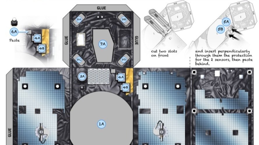
Print out, cut out and assemble your own model of a Galileo navigation satellite
Greta Thunberg arrives in New York for UN Climate Talks
28.8.2019 15:00 ESA Observing the Earth
Climate campaigner Greta Thunberg has arrived in New York after a two-week sail across the Atlantic, ready to attend the United Nations Climate Action Summit at the end of September.
Podpořili jsme akci Divadélkování ve Ville Hrdlička
28.8.2019 12:41 HrdličkaZpříjemněte dětem začátek školního roku loutkovým divadlem s bohatým doprovodným programem. Součástí Divadélkování je i malování na obličej nebo zkouška dětských kostýmů. Těšit se můžete na obrázkovou výstavu dětí ze ZUŠ, výstavu o historii Villy Hrdlička či výstavu hraček původních majitelů této krásné secesní budovy. K dispozici bude připraven i dětský koutek. Autor článku: Ing.... View Article
The post Podpořili jsme akci Divadélkování ve Ville Hrdlička appeared first on HRDLIČKA spol. s r.o. - komplexní služby v oblasti geodézie.
Nefunkční telefonní linky
28.8.2019 12:00 ČÚZK /Urady/Katastralni-urady/Katastralni-urady/Katastralni-urad-pro-Ustecky-kraj/Katastralni-pracoviste/KP-Teplice/O-uradu/Aktuality/Nefunkcni-telefonni-linkyNefunkční telefonní linky
28.8.2019 12:00 ČÚZK - předpisy a opatření Katastrální úřad pro Ústecký kraj - Katastrální pracoviště Teplicezveřejnil novou aktualitu: Vážení klienti, oznamujeme Vám, že v současné době máme poruchu na telefonní lince. Na opravě se pracuje. Za způsobené komplikace se omlouváme.
Observatoř Gaia odhaluje hvězdné sourozence v Mléčné dráze
28.8.2019 10:55 Český Kosmický PortálNež by opustili domov mladí, tak se hvězdní „sourozenci“ raději zdržují v dlouhodobě stabilních strunových skupinách. Zjistila to nová studie využívající data z observatoře ESA Gaia.
"EAS 2019: Connecting, Exploring, and Transforming Geospatial Data" by Jeff Rowe
28.8.2019 10:34 GISCafe.com Webcasts-WebinarsOrbit GT to exhibit and showcase v20 at INTERGEO, Stuttgart, Germany
28.8.2019 10:17 GISCafe.com Webcasts-Webinars Lokeren, Belgium, August 27th, 2019 -- Orbit GT will be exhibiting and showing version 20 of its 3D Mapping portfolio at INTERGEO, Stuttgart, …20190828 Odborný rada oddělení právních vztahů k nemovitostem
28.8.2019 9:58 ČÚZK /Urady/Katastralni-urady/Katastralni-urady/Katastralni-urad-pro-Stredocesky-kraj/Katastralni-pracoviste/KP-Beroun/O-uradu/Aktuality/20190828-Odborny-rada-oddeleni-pravnich-vztahu-k-n20190828 Odborný rada oddělení právních vztahů k nemovitostem
28.8.2019 9:58 ČÚZK - předpisy a opatření Katastrální úřad pro Středočeský kraj - Katastrální pracoviště Beroun Vyhlášení výběrového řízení: Odborný rada oddělení právních vztahů k nemovitostem V části "Úřední deska", v sekci "Oznámení a jiná úřední sdělení" bylo vystaveno "Oznámení o vyhlášení výběrového řízení na obsazení služebního místa Odborný rada oddělení právních vztahů k nemovitostem"20190828 Odborný rada oddělení právních vztahů k nemovitostem
28.8.2019 9:53 ČÚZK - předpisy a opatření Katastrální úřad pro Středočeský kraj - Katastrální pracoviště Beroun Vyhlášení výběrového řízení: Odborný rada oddělení právních vztahů k nemovitostem V části "Úřední deska", v sekci "Oznámení a jiná úřední sdělení" bylo vystaveno "Oznámení o vyhlášení výběrového řízení na obsazení služebního místa Odborný rada oddělení právních vztahů k nemovitostem"20190828 Odborný rada oddělení právních vztahů k nemovitostem
28.8.2019 9:53 ČÚZK /Urady/Katastralni-urady/Katastralni-urady/Katastralni-urad-pro-Stredocesky-kraj/O-uradu/Aktuality/20190828-Odborny-rada-oddeleni-pravnich-vztahu-k-nOdborný referent oddělení právních vztahů k nemovitostem
28.8.2019 9:44 ČÚZK - volná místa Katastrální úřad pro Středočeský kraj - Katastrální pracoviště Beroun vypisuje výběrové řízení na místo Odborný referent oddělení právních vztahů k nemovitostemOdborný referent oddělení právních vztahů k nemovitostem
28.8.2019 9:44 ČÚZK - předpisy a opatření Katastrální úřad pro Středočeský kraj - Katastrální pracoviště Berounvypisuje výběrové řízení na místo Odborný rada oddělení právních vztahů k nemovitostem
Odborný referent oddělení právních vztahů k nemovitostem
Pozvánka na výstavu Dopravní mapy a plány
28.8.2019 7:00 Česká asociace pro geoinformaceV badatelně Ústředního archivu zeměměřictví a katastru v Praze bude 6. září 2019 zahájena výstava Dopravní mapy a plány.
Co bude na vístavě k vidění prozradí přiložená pozvánka.
V badatelně Ústředního archivu zeměměřictví a katastru v Praze bude 6. září 2019 zahájena výstava Dopravní mapy a plány.
Co bude na výstavě k vidění prozradí přiložená
23. kartografická konference - program zveřejněn
28.8.2019 7:00 Česká asociace pro geoinformaceOrganizátoři 23. kartografické konference zveřejnili na webu akce její program.
Konference proběhne od 18. do 20. září v Kutné Hoře. Akci s podtitulem Kartografie v proměnách času pořádá Česká kartografická společnost tentokrát ve spolupráci s katedrou aplikované geoinformatiky a kartografie PřF UK a katedrou geomatiky ČVUT.
Více informací naleznete na
Nabídka pracovní pozice: Programátor routovacích služeb pro mapové aplikace
28.8.2019 7:00 Česká asociace pro geoinformace Společnost CEDA hledá Programátora routovacích služeb pro mapovéHPE Delivers Q3 Results
27.8.2019 23:48 GISCafe.com Webcasts-Webinars Q3 2019 Financial Highlights:Revenue: $7.2 billion
Gross Margins: 33.9%, up 340 basis points from the prior-year period
Diluted Net Earnings …
Autodesk, Inc. Announces Fiscal 2020 Second Quarter Results
27.8.2019 23:48 GISCafe.com Webcasts-Webinars - Record Last Twelve Months Operating and Free Cash Flow of $791 Million and $731 Million, RespectivelySAN RAFAEL, Calif., Aug. 27, 2019 — …
Avineon Joins Esri Partner Network Gold Program
27.8.2019 17:34 GISCafe.com Webcasts-Webinars MCLEAN, Va., Aug. 27, 2019 (GLOBE NEWSWIRE) -- Avineon, Inc. (Avineon), a global provider of information technology and engineering support, has …Maxar Technologies Awarded Four-Year Global EGD Contract by the U.S. Government for On-Demand Access to Mission-Ready Satellite Imagery
27.8.2019 17:34 GISCafe.com Webcasts-Webinars WESTMINSTER, Colo. — (BUSINESS WIRE) — August 27, 2019 —Maxar Technologies (NYSE:MAXR) (TSX:MAXR), a trusted partner and …
Florida’s Jackson County Chooses DATAMARK to Solve NG9-1-1 GIS Challenges in Wake of Natural Disaster
27.8.2019 17:34 GISCafe.com Webcasts-Webinars TALLAHASSEE, Fla., Aug. 27, 2019 (GLOBE NEWSWIRE) -- Rural Jackson County, Florida selected DATAMARK VEP for its geographic information systems …6D.ai Lays The Foundation to Build 3D Map of The World
27.8.2019 17:33 GISCafe.com Webcasts-Webinars Announces Commercial Availability, Qualcomm Technologies Cooperation, and new Android SolutionSAN FRANCISCO, Aug. 27, 2019 — (PRNewswire) …
You Don’t Need a Drone to Reap the Benefits of Photogrammetry
27.8.2019 17:01 Carlson Software Let’s say you’ve got a 30-acre site, gently rolling, open – just the place for the new shopping center or car dealership. You’re to deliver a topo survey with 2’ contours. Twenty years ago, you would have sent a crew of three. Today, because of the improvements in surveying instruments, you only send two. Back […]Raft of rubble
27.8.2019 15:49 ESA Observing the Earth
This Copernicus Sentinel-2 image features a huge raft of pumice rock drifting in the Pacific Ocean
Den otevřených dveří v ESA vzhlíží k Měsíci
27.8.2019 12:37 Český Kosmický PortálPřijďte v říjnu do technického srdce ESA! Potkat zde můžete astronauty z programu Apollo nebo inženýry ESA, kteří připravují budoucí evropské mise na Měsíc. Letos se „den otevřených dveří“ ve středisku ESA ESTEC v nizozemském Noordwijku uskuteční v neděli 6. října. Všichni jste vítáni!
Knihovny ve Středočeském kraji
27.8.2019 12:30 Středočeský kraj Pro pracovníky informačních center a veřejnost byla spuštěna nová webová mapa Knihovny ve Středočeském kraji. Cílem bylo shromáždit základní informace o knihovnách Středočeského kraje na jednom místě, jasně a přehledně. Interaktivní mapa nabízí vizualizaci knihoven podle obsluhy a spádovosti do regionu pověřených knihoven. Dále nabízí podrobnější informace, jako např. otevírací doba, webové stránky, kontakty prostřednictvím odkazu na webový server www.knihovny.cz. Pro navigační účely je mapa propojena i s mapovým serverem Mapy.cz. Aplikaci vč. koncepce a metodiky připravil Odbor informatiky ve spolupráci s příspěvkovou organizací, Středočeská vědecká knihovna v Kladně. Tento projekt vznikl na podnět Odboru kultury a památkové péče.Dopravní mapy a plány - výstava Ústředního archivu zeměměřičství a katastru [Knihovna geografie, byTopic]
27.8.2019 12:00 Katedra aplikované geoinformatiky a kartografie Přf UK Výstava bude zahájena 6. září 2019 v 9 hodin v badatelně archivuSpationomy – závěrečná konference
27.8.2019 10:59 GISportal.cz
Koncem minulého týdne se v Olomouci uskutečnila závěrečná mezinárodní konference, která završila tříletý projekt Spationomy. Ten si kladl za cíl propojit svět geoinformatiky a ekonomie a pomocí moderních výukových metod rozvíjet spolupráci studentů v multioborových týmech. Konference se konala ve čtvrtek 22. srpna 2019 v BEA Centru Olomouc. Sjeli se sem nejen účastníci projektu ze […]
The post Spationomy – závěrečná konference appeared first on GISportal.cz.
"NE Patriots/Gillette Stadium? Google Maps Says, “No Way” "by Stewart Berry
27.8.2019 10:36 GISCafe.com Webcasts-WebinarsGSA GNSS Market Report 6 – coming soon!
27.8.2019 9:18 European GNSS Agency
The 2019 edition of the GSA’s GNSS Market Report will be launched in the autumn. As in previous years, the latest issue of the report will provide comprehensive information on the dynamic global GNSS market along with in-depth analysis of the latest global GNSS trends and developments. To be among the first to receive the Market Report straight into your inbox , register here.
With more than 60,000 downloads since it was published online in May 2017, the previous edition of the GNSS Market Report has proved to be an essential tool for all market players, from research institutions and industry to the various user communities, providing them with a comprehensive overview of the current status and future trends on the GNSS market.
Regularly referenced by policy-makers and business leaders around the world, the publication has established itself as the most authoritative reference document for information on the global GNSS market.
A sneak peek
The 2019 edition of the report will continue this tradition and build on the success of the previous reports. The structure of this year’s report is similar to previous years and will include:
- A general overview of the GNSS market, including user requirements, forecasts for future shipments, revenues and the GNSS installed base, a global industry overview, and synergies between EGNSS and Copernicus;
- Analysis of macro-trends affecting GNSS, including climate change and the circular economy, big data, artificial intelligence, the silver economy, cyber security and the sharing economy, that impact the adoption of GNSS solutions;
- A review of the main GNSS market segments, which have increased to 10 in this year’s report: Consumer Solutions, Road, Manned Aviation, Drones, Maritime, Emergency Response, Rail, Agriculture, Geomatics and Critical Infrastructure.
The GNSS market segment review forms the core of the report and provides a summary of GNSS applications in each segment with an overview of user needs and requirements, value chain and relevant European GNSS differentiators for each specific segment. Also included in this section is analysis of key trends and recent developments in each segment and predictions on how the market will evolve, with forecasts for shipments and revenues over the next decade.
Editor’s Special – GNSS for New Space
Though originally conceived for terrestrial use, GNSS has also proven its worth as a valuable tool for in-space applications, and it is these in-space applications that are the focus of the Editor’s Special section in this year’s market report.
Formerly used mainly by governmental space entities, GNSS now also serves an increasing number of commercial stakeholders within the ‘New Space’ paradigm, providing the following in-space applications: real-time on-board autonomous navigation, attitude determination, Earth science applications and timing and synchronisation for satellites.
The Editor’s Special section examines key trends behind the rapid growth in the number of spacecraft with a particular focus on growth in private LEO service providers and on Galileo’s contribution to the Space Service Volume (SSV).
Don’t miss out!
The 2019 GNSS Market Report will be available to download for free. Don’t miss out on this opportunity to tap into the latest trends and developments on the GNSS market. To receive an e-mail notification when the Market Report will be available, register here.
Media note: This feature can be republished without charge provided the European GNSS Agency (GSA) is acknowledged as the source at the top or the bottom of the story. You must request permission before you use any of the photographs on the site. If you republish, we would be grateful if you could link back to the GSA website (http://www.gsa.europa.eu).
Fires ravage the Amazon
27.8.2019 9:15 ESA Observing the Earth
Thousands of fires have broken out in the Amazon rainforest. Satellite data show that there are almost four times as many fires this year compared to the same period last year. Apart from Brazil, parts of Peru, Bolivia, Paraguay and Argentina have also been affected.
referent KN – právník do právního oddělení XI.
27.8.2019 8:08 ČÚZK /Urady/Katastralni-urady/Katastralni-urady/Katastralni-urad-pro-hlavni-mesto-Prahu/O-uradu/Aktuality/referent-KN-–-pravnik-do-pravniho-oddeleni-XIreferent KN – právník do právního oddělení XI.
27.8.2019 8:08 ČÚZK - předpisy a opatření Katastrální úřad pro hlavní město Prahu zveřejnil novou aktualitu: Ředitel úřadu vyhlašuje výběrové řízení na služební místo:referent KN – právník do právního oddělení XI.
referent KN – právník do právního oddělení XI.
27.8.2019 8:01 ČÚZK - předpisy a opatření Katastrální úřad pro hlavní město Prahuvypisuje výběrové řízení na místo
referent KN – právník do právního oddělení XI.
referent KN – právník do právního oddělení XI.
27.8.2019 8:01 ČÚZK - volná místa Katastrální úřad pro hlavní město Prahu vypisuje výběrové řízení na místo referent KN – právník do právního oddělení XI.referent KN – právník do právního oddělení XI.
27.8.2019 8:01 ČÚZK /Urady/Katastralni-urady/Katastralni-urady/Katastralni-urad-pro-hlavni-mesto-Prahu/Uredni-deska/Oznameni-a-jina-uredni-sdeleni/Volna-mista/referent-KN-–-pravnik-do-pravniho-oddeleni-XIPivvot™ Celebrates One-Year Anniversary
26.8.2019 20:02 GISCafe.com Webcasts-Webinars Pivvot™ celebrates successful first year of providing location data and analytics solutions to the energy and transportation …Microsol Resources Partners with GeoSLAM for 3D Mobile Mapping
26.8.2019 19:37 GISCafe.com Webcasts-Webinars NEW YORK, Aug. 26, 2019 — (PRNewswire) — Microsol Resources Corporation—a recognized leader in building information modeling …Smart Title Blocks
26.8.2019 18:21 Carlson Software Carlson software contains a lot of tools to help you get your survey and/or engineering work done quicker and more efficiently. Programs like Field to Finish, Road Network and SiteNET are just a few of the examples of programs that drastically speed up the time it takes to complete a project from processing raw field […]Z důvodu změn na serverech ČÚZ
26.8.2019 17:27 GEUSware Z důvodu změn na serverech ČÚZK přestaly v GEUSu fungovat některé s nimi komunikující funkce. Pracujeme na opravě, během příštího týdne uvolníme nové sestavení programu GEUS.Hawaii DOT is Liking Carlson
26.8.2019 17:13 Carlson Software One aspect of Carlson Civil that Daniel Sasaki, Land Surveyor III of the Hawaii DOT, happened upon and decided he really liked was the drive-through option. “You choose a car and you can have it ‘drive’ over your profile so it shows you if there’s a hump or bump in the road,” he said. “It’s […]Hawaii is Liking Carlson
26.8.2019 17:13 Carlson Software One aspect of Carlson Civil that Daniel Sasaki, Land Surveyor III of the Hawaii DOT, happened upon and decided he really liked was the drive-through option. “You choose a car and you can have it ‘drive’ over your profile so it shows you if there’s a hump or bump in the road,” he said. “It’s […]Maxar Technologies to Attend Upcoming Investor Conferences
26.8.2019 17:00 GISCafe.com Webcasts-Webinars WESTMINSTER, Colo. — (BUSINESS WIRE) — August 26, 2019 —Maxar Technologies (NYSE:MAXR) (TSX:MAXR), a trusted partner and …
Pitney Bowes Announces Sale of its Software Solutions Business to Syncsort for $700 million
26.8.2019 17:00 GISCafe.com Webcasts-Webinars Sale unlocks value for shareholders while advancing the Company’s transformation efforts to focus on removing the complexities of shipping and …VŘ KP OL
26.8.2019 15:15 ČÚZK - předpisy a opatření Katastrální úřad pro Olomoucký kraj zveřejnil novou aktualitu: OZNÁMENÍ O VYHLÁŠENÍ VÝBĚROVÉHO ŘÍZENÍ na služební místo:rada/odborný rada – rozhodování o povolení vkladu, na Katastrálním pracovišti Olomouc Katastrálního úřadu pro Olomoucký kraj.
VŘ KP OL
26.8.2019 15:15 ČÚZK /Urady/Katastralni-urady/Katastralni-urady/Katastralni-urad-pro-Olomoucky-kraj/O-uradu/Aktuality/VR-KP-OLV INSPIRE ubývají povinnosti
26.8.2019 15:09 CENIA - národní geoportál INSPIRE Dne 19. 8. 2019 vyšlo v úředním věstníku Evropské komise rozhodnutí 2019/1372 k monitoringu a reportingu v INSPIRE. Povinnosti ke způsobu předávání a výpočtu indikátorů o využívání infrastruktury INSPIRE stanovené původním rozhodnutím 2009/442/ES se nyní ruší a budou nahrazeny novým způsobem. Nově nebudou potřebné informace předávány samotnými poskytovateli prostřednictvím geoportálu, ale budou...Pokračuje testování padáků pro misi ExoMars
26.8.2019 12:36 Český Kosmický PortálS tím, jak se blíží start druhé mise řady ExoMars, která se bude skládat z roveru a statické přístrojové platformy a která má opustit Zemi v příštím roce, pokračují týmy v řešení problémů s padákovým systémem. Ty odhalil neúspěšný výškový test minulý týden.
Knihovna je opět otevřena [Knihovna geografie, byTopic]
26.8.2019 10:30 Katedra aplikované geoinformatiky a kartografie Přf UK 26. 8. -30. 8. 2019 denně 9-11.00Vrchní referent/rada v oddělení aktualizace KN č. 2 na Katastrálním pracovišti Znojmo
26.8.2019 9:39 ČÚZK /Urady/Katastralni-urady/Katastralni-urady/Katastralni-urad-pro-Jihomoravsky-kraj/Volna-mista/Vrchni-referent-rada-v-oddeleni-aktualizace-KN-(1)Vrchní referent/rada v oddělení aktualizace KN č. 2 na Katastrálním pracovišti Znojmo
26.8.2019 9:39 ČÚZK - volná místa Katastrální úřad pro Jihomoravský kraj - Katastrální pracoviště Znojmo vypisuje výběrové řízení na místo Vrchní referent/rada v oddělení aktualizace KN č. 2 na Katastrálním pracovišti ZnojmoVrchní referent/rada v oddělení aktualizace KN č. 2 na Katastrálním pracovišti Znojmo
26.8.2019 9:39 ČÚZK - předpisy a opatření Katastrální úřad pro Jihomoravský kraj - Katastrální pracoviště Znojmonabízí služební místo
Vrchní referent/rada v oddělení aktualizace KN č. 2 na Katastrálním pracovišti Znojmo
ČÚZK – krátkodobé přerušení provozu DP a WSDP
26.8.2019 9:04 GEPROČÚZK plánuje přerušit provoz Dálkového přístupu (DP) a Webových služeb dálkového přístupu (WSDP) ve čtvrtek 29.… >>
Kartografická výročí 2019 (pozvánka)
26.8.2019 8:44 GISportal.cz
Kartografická výročí 2019 – odborný seminář ku příležitosti 450 let Fabriciovy mapy Moravy a 400 let Aretinovy mapy Čech Termín konání: 9.10.2019 (10:00 – 15:30) Místo konání: Moravský zemský archiv v Brně Pořádá: Česká kartografická společnost, Moravský zemský archiv v Brně, Geografický ústav PřF MU a Mapová sbírka PřF, UK. Formulář pro přihlášky V letošním roce uplyne 450 […]
The post Kartografická výročí 2019 (pozvánka) appeared first on GISportal.cz.
Nepřírodní biotopy – mapování 2007-2019
26.8.2019 2:00 Cenia - Katalog metadat ČR - INSPIRE Hranice segmentů biotopů silně ovlivněných nebo vytvořených člověkem, pokud byly zaznamenány při aktualizaci mapování biotopů přírodních a přírodně blízkých. Znalost rozšíření nepřírodních biotopů tedy není plošná, vrstva poskytuje informace o rozšíření nepřírodních biotopů pouze na malé části území ČR.Data z mapování biotopů neposkytují vyčerpávající informaci o vegetaci, resp. biotopech daného území. Mapování je metodicky nastaveno na celostátní úrovni, a především efemérní biotopy tak může pominout. V lokálním měřítku proto představuje pouze zjednodušený podklad. Pro detailnější informaci je třeba vyhledat jiné datové zdroje. Mapování biotopů je opakováno ve dvanáctileté periodě. Základní mapování bylo provedeno v letech 2001–2005.Klasifikace biotopů viz CHYTRÝ, M.; KUČERA, T.; KOČÍ, M. (eds.) et al. (2010). Katalog biotopů České republiky. 2.upr. a rozš.vyd. Praha: Agentura ochrany přírody a krajiny ČR. 445 s. ISBN 978-80-87457-03-0.Popis charakteristik biotopů a segmentů viz platná metodika mapování biotopů (Portál ISOP/Mapování biotopů). Vrstva obsahuje jednoduché prvky (Singlepart Features), kardinalita vztahu mezi záznamy v tabulkách 1 : N. © AOPK ČR, 2019Přírodní biotopy (aktualizace základního mapování biotopů)
26.8.2019 2:00 Cenia - Katalog metadat ČR - INSPIRE Hranice segmentů přírodních biotopů a relační databáze jejich charakteristik z aktualizace základního mapování biotopů; klasifikace biotopů viz CHYTRÝ, M.; KUČERA, T.; KOČÍ, M. (eds.) et al. (2010). Katalog biotopů České republiky. 2.upr. a rozš.vyd. Praha: Agentura ochrany přírody a krajiny ČR. 445 s. ISBN 978-80-87457-03-0.; popis charakteristik biotopů a segmentů viz platná metodika mapování biotopů (Portál ISOP/Mapování biotopů); vrstva obsahuje jednoduché prvky (Singlepart Features), kardinalita vztahu mezi záznamy v tabulkách 1 : N; © AOPK ČR, 2019Data z mapování biotopů neposkytují vyčerpávající informaci o vegetaci, resp. biotopech daného území. Mapování biotopů je opakováno v pravidelných cyklech (frekvence cyklů aktualizace je plánována jako 12letá), především efemérní biotopy mohou být pominuty. Je metodicky nastaveno na celostátní úrovni, v lokálním měřítku je pouze zjednodušeným podkladem. Pro detailnější informaci je třeba odborný průzkum či konzultace.Aktualizace základního mapování biotopů
26.8.2019 2:00 Cenia - Katalog metadat ČR - INSPIRE Aktualizace vrstvy segmentů biotopů a relačních databází (biotopy, taxony) probíhá v pravidelných cyklech. Frekvence cyklů aktualizace je plánována jako 12letá. Aktualizace byla zahájena v roce 2007. Ve vrstvě a tabulkách jsou aktualizované a neaktualizované záznamy (pole ROK_AKT). Vrstva obsahuje hranice segmentů přírodních biotopů a biotopů silně ovlivněných nebo vytvořených člověkem z aktualizace základního mapování biotopů. Znalost rozšíření biotopů silně ovlivněných nebo vytvořených člověkem není plošná, vrstva poskytuje informace o rozšíření nepřírodních biotopů pouze na malé části území ČR.Data z mapování biotopů neposkytují vyčerpávající informaci o vegetaci, resp. biotopech daného území. Mapování je metodicky nastaveno na celostátní úrovni, a především efemérní biotopy tak může pominout. V lokálním měřítku proto představuje pouze zjednodušený podklad. Pro detailnější informaci je třeba vyhledat jiné datové zdroje. Základní mapování bylo provedeno v letech 2001–2005.Klasifikace biotopů viz CHYTRÝ, M.; KUČERA, T.; KOČÍ, M. (eds.) et al. (2010). Katalog biotopů České republiky. 2.upr. a rozš.vyd. Praha: Agentura ochrany přírody a krajiny ČR. 445 s. ISBN 978-80-87457-03-0.Popis charakteristik biotopů a segmentů viz platná metodika mapování biotopů (Portál ISOP/Mapování biotopů). Botanická nomenklatura převzata z Nálezové databáze OP (http://isop.nature.cz/redlist/v_nd_taxon_category.php). Vrstva obsahuje jednoduché prvky (Singlepart Features), kardinalita vztahu tabulek je 1 : N. © AOPK ČR, 2019Formační skupiny přírodních biotopů
26.8.2019 2:00 Cenia - Katalog metadat ČR - INSPIRE Zastoupení formačních skupin přírodních biotopů na území ČR (přehled formačních skupin viz CHYTRÝ, M.; KUČERA, T.; KOČÍ, M. (eds.) et al. (2010). Katalog biotopů České republiky. 2. upr. a rozš. vyd. Praha: Agentura ochrany přírody a krajiny ČR. 445 s. ISBN 978-80-87457-03-0.); vrstva obsahuje jednoduché prvky (Singlepart Features); © AOPK ČR, 2019Habitaty (aktualizace základního mapování biotopů)
26.8.2019 2:00 Cenia - Katalog metadat ČR - INSPIRE Hranice segmentů habitatů a relační databáze jejich charakteristik z aktualizace základního mapování biotopů; převodní tabulka habitatů viz CHYTRÝ, M.; KUČERA, T.; KOČÍ, M. (eds.) et al. (2010). Katalog biotopů České republiky. 2.upr. a rozš.vyd. Praha: Agentura ochrany přírody a krajiny ČR. 445 s. ISBN 978-80-87457-03-0.; vrstva obsahuje jednoduché prvky (Singlepart Features), kardinalita vztahu mezi záznamy v tabulkách 1 : N; © AOPK ČR, 2019Data z mapování biotopů neposkytují vyčerpávající informaci o vegetaci, resp. biotopech daného území. Mapování biotopů je opakováno v pravidelných cyklech (frekvence cyklů aktualizace je plánována jako 12letá), především efemérní biotopy mohou být pominuty. Je metodicky nastaveno na celostátní úrovni, v lokálním měřítku je pouze zjednodušeným podkladem. Pro detailnější informaci je třeba odborný průzkum či konzultace.MMC UAV is Improving its Industrial UAV Leadership by Industrial Synergy Strength
23.8.2019 18:44 GISCafe.com Webcasts-Webinars 2019 Global UAV Market -- China is Claiming the ThroneSHENZHEN, China, Aug. 23, 2019 — (PRNewswire) — Over the past years, unmanned …
Hledáme programátora a vývojáře
23.8.2019 12:45 CEDA Maps a.s. Hlednáme nové kolegy do týmu. Přidejte se k nám.Přerušení provozu DP a WSDP ve čtvrtek 29.8.2019 od 16:30 až do cca 18:00.
23.8.2019 11:40 ČÚZK - předpisy a opatření Vážení uživatelé,oznamujeme, že ve čtvrtek 29.8.2019 od 16:30 bude z provozních důvodů zcela přerušen provoz Dálkového přístupu i Webových služeb dálkového přístupu. Obnovení provozu předpokládáme v cca 18:00 hodin.
Za komplikace tímto způsobené se omlouváme a děkujeme za pochopení.
Přerušení provozu DP a WSDP ve čtvrtek 29.8.2019 od 16:30 až do cca 18:00.
23.8.2019 11:40 ČÚZK /Aplikace-DP-do-KN/Aplikace-DP-do-KN/Archiv-DP/265750Přerušení provozu DP a WSDP ve čtvrtek 29.8.2019 od 16:30 až do cca 18:00.
23.8.2019 11:40 Dálkový přístup k údajům KN ČR Vážení uživatelé,oznamujeme, že ve čtvrtek 29.8.2019 od 16:30 bude z provozních důvodů zcela přerušen provoz Dálkového přístupu i Webových služeb dálkového přístupu. Obnovení provozu předpokládáme v cca 18:00 hodin.
Za komplikace tímto způsobené se omlouváme a děkujeme za pochopení.
"AMD GPUs, CPUs and Software Accelerate Performance for Many Applications & Industries" by Sanjay Gangal
23.8.2019 11:10 GISCafe.com Webcasts-WebinarsDroneUp Makes Impact at InterDrone 2019
23.8.2019 11:02 GISCafe.com Webcasts-Webinars Virginia Beach, VA (August 22, 2019) -- DroneUp, LLC, an end-to-end drone pilot service provider for aerial data collection, will showcase its …"UAV/LiDAR Fusion by Design with TrueView from GeoCue" by Susan Smith
23.8.2019 10:38 GISCafe.com Webcasts-WebinarsEarth Observation Hackathon (pozvánka)
23.8.2019 9:21 GISportal.cz
Organizátoři Vás zvou na Copernicus Hackathon, tedy soutěž pro všechny, kteří mají rádi výzvy nebo se zajímají o družicová data a práci s nimi. Akce proběhne poslední víkend v září, a to od pátku 27. 9. do neděle 29. 9., přímo v novém sídle firmy – TechNest – které je v Brně v Technologickém parku. Cílem […]
The post Earth Observation Hackathon (pozvánka) appeared first on GISportal.cz.
Kosmonaut ESA Thomas Pesquet se vydal na nové podmořské dobrodružství
23.8.2019 7:52 Český Kosmický PortálV následujících dvou týdnech budou kosmonaut ESA Thomas Pesquet, astronaut NASA Drew Feustel a japonský astronaut Norišige Kanaj tvořit posádku nové mise NEEMO (NASA Extreme Environment Mission Operations), a to u pobřeží Kalifornie. Zde budou vyhodnocovat koncepty podmořského výcviku, které by měly pomoci realizovat další lidské kroky na Měsíci.
HP Announces CEO Succession
22.8.2019 23:20 GISCafe.com Webcasts-Webinars Enrique Lores appointed President and CEO of HP Inc. effective November 1, 2019 Dion Weisler to step down while remaining a director on the …HP Inc. Reports Fiscal 2019 Third Quarter Results
22.8.2019 23:20 GISCafe.com Webcasts-Webinars PALO ALTO, Calif., Aug. 22, 2019 (GLOBE NEWSWIRE) -- HP (NYSE: HPQ) Third quarter GAAP diluted net earnings per share ("EPS") of $0.78, above …GPS III Satellite Launches with BAE Systems RAD750 Single Board Computers
22.8.2019 19:42 GISCafe.com Webcasts-Webinars MANASSAS, Va. — (BUSINESS WIRE) — August 22, 2019 —The U.S. Air Force today launched its second GPS III satellite, the most …
Airbus Aerial Receives Waiver for Urban BVLOS UAS Flight Operations Over Populated Areas in North Dakota
22.8.2019 19:42 GISCafe.com Webcasts-Webinars GRAND FORKS, N.D., Aug. 22, 2019 (GLOBE NEWSWIRE) -- Airbus Aerial has been granted a waiver by the Federal Aviation Administration (FAA) to …ÚAZK zve na výstavu dopravních map a plánů
22.8.2019 19:40 ZeměměřičÚstřední archiv zeměměřictví a katastru zve na výstavu dopravních map a plánů. Výstava bude přístupná od 7. září 2019 v badatelně archivu (Pod Sídlištěm 9, 182 11 Praha 8 – Kobylisy). Dopravní mapy a plány jsou druhem tematického mapového díla, které na základním topografickém podkladu (není však podmínkou), vhodnými grafickými prostředky a v podrobnosti dle zvoleného měřítka mapy a plánu představují příslušné vybrané dopravní […]
The post ÚAZK zve na výstavu dopravních map a plánů appeared first on Zeměměřič.
ÚAZK zve na výstavu dopravních map a plánů
22.8.2019 19:40 ZeměměřičÚstřední archiv zeměměřictví a katastru zve na výstavu dopravních map a plánů. Výstava bude přístupná 6. září 2019 od 13:00 do 15:00 hod. v badatelně archivu (Pod Sídlištěm 9, 182 11 Praha 8 – Kobylisy). Dopravní mapy a plány jsou druhem tematického mapového díla, které na základním topografickém podkladu (není však podmínkou), vhodnými grafickými prostředky a v podrobnosti dle zvoleného měřítka mapy a plánu […]
The post ÚAZK zve na výstavu dopravních map a plánů appeared first on Zeměměřič.
ÚAZK zve na výstavu dopravních map a plánů
22.8.2019 19:40 ZeměměřičÚstřední archiv zeměměřictví a katastru zve na výstavu dopravních map a plánů. Výstava bude zahájena 6. září 2019 v 9 hodin v badatelně archivu (Pod Sídlištěm 9, 182 11 Praha 8 – Kobylisy). Dopravní mapy a plány jsou druhem tematického mapového díla, které na základním topografickém podkladu (není však podmínkou), vhodnými grafickými prostředky a v podrobnosti dle zvoleného měřítka mapy a plánu představují příslušné vybrané […]
The post ÚAZK zve na výstavu dopravních map a plánů appeared first on Zeměměřič.
Capella Space Partners with SpaceNet® to Expand Access to SAR Data
22.8.2019 17:21 GISCafe.com Webcasts-Webinars Initiative to foster broad SAR adoption and accelerate machine learning applicationsSAN FRANCISCO, August 21, 2019 -- Capella Space, an information …