


![]()

zprávy
zdroje zpráv:Dotazník: Jaké je využití prostorových dat ve vaší organizaci?
21.4.2016 7:00 Česká asociace pro geoinformaceDotazník využití prostorových dat ve Vaší společnosti byl vytvořen v rámci projektu Technologické agentury České republiky „Vypracování analytického návrhu modelu financování datového fondu klíčových prostorových informací“ řešeného pro Ministerstvo vnitra České republiky v návaznosti na Akční plán GeoInfoStrategie, jež byl schválen usnesením vlády ČR
Gefos - prezentace ze setkání zákazníků
21.4.2016 7:00 Česká asociace pro geoinformace Na webu společnosti Gefos naleznete prezentace příspěvků z letošního Setkání. Pokud jste z jakéhokoli důvodu nemohli na akci dorazit, jistě nepohrdnete tímtoV části Odkazy - Webové služby
20.4.2016 12:00 Plzeňský kraj V části Odkazy - Webové služby byl doplněn odkaz a informace o možnosti připojení jednotlivých územních plánů obcí pomocí WMS (Webových Mapových Služeb).V části Odkazy - Webové služby
20.4.2016 12:00 Plzeňský kraj V části Odkazy - Webové služby (http://geoportal.plzensky-kraj.cz/gs/webove-sluzby/) byl doplněn odkaz a informace o možnosti připojení jednotlivých územních plánů obcí pomocí WMS (Webových Mapových Služeb).2016
20.4.2016 10:24 ČÚZK - předpisy a opatření Katastrální úřad pro Středočeský krajZverejnení obsahu informací poskytnutých na žádost dle zákona c. 106/1999 Sb.
2016
Národní kulturní památky - vymezení rozsahu ochrany
20.4.2016 2:00 Cenia - Katalog metadat ČR - INSPIRE Plošná / polygonová vymezení rozsahu nemovitých národních kulturních památek s připojenými základními atributy evidovanými v USKP (aplikaci Památkový katalog).Ochranná pásma - bodová identifikace
20.4.2016 2:00 Cenia - Katalog metadat ČR - INSPIRE Definiční body ochranných pásem s připojenými základními atributy evidovanými v USKP (aplikaci Památkový katalog).Národní kulturní památky - bodová identifikace
20.4.2016 2:00 Cenia - Katalog metadat ČR - INSPIRE Definiční body nemovitých národních kulturních památek s připojenými základními atributy evidovanými v USKP (aplikaci Památkový katalog).Památkové rezervace - bodová identifikace
20.4.2016 2:00 Cenia - Katalog metadat ČR - INSPIRE Definiční body památkových rezervací s připojenými základními atributy evidovanými v USKP (aplikaci Památkový katalog).Krajinné památkové zóny - vymezení rozsahu ochrany
20.4.2016 2:00 Cenia - Katalog metadat ČR - INSPIRE Plošná / polygonová vymezení rozsahu krajinných památkových zón s připojenými základními atributy evidovanými v USKP (aplikaci Památkový katalog).Ochranná pásma - vymezení rozsahu
20.4.2016 2:00 Cenia - Katalog metadat ČR - INSPIRE Plošná / polygonová vymezení rozsahu ochranných pásem s připojenými základními atributy evidovanými v USKP (aplikaci Památkový katalog).Plány Státní regulační komise pro Prahu a okolí (1920 - 1939)
20.4.2016 2:00 Cenia - Katalog metadat ČR - INSPIRE Službu tvoří rastrové reprezentace dílčích, celkových, přehledných a schematických plánů Státní regulační komise pro Prahu a okolí z předválečného období. Dílčí plány SRK je ve službě možné zobrazovat po jednotlivých katastrálních územích. Celkové, přehledné a schematické plány zobrazují celé tehdejší území hl. m. Prahy.Plány pocházejí ze spisovny IPR. Po naskenování byly oříznuty dle hranic správních celků a transformovány do souřadného systému S-JTSK metodou identických bodů. Měřítko všech plánů je 1:2 800. Prostorové rozlišení rastrů závisí na rozlišení skenovaných map a pohybuje se okolo 0,3 m.Kulturní památky - bodová identifikace
20.4.2016 2:00 Cenia - Katalog metadat ČR - INSPIRE Definiční body nemovitých kulturních památek s připojenými základními atributy evidovanými v USKP (aplikaci Památkový katalog).Pěší síť
19.4.2016 2:00 Cenia - Katalog metadat ČR - INSPIRE Zobrazuje pěší síť v členění na chodníky, pasáže, nezpevněné cesty a nábližky, silnice bez chodníku a mimoúrovně. Data této služby mohou být použita i pro síťové analýzy.Zóny města - parkovací stání
19.4.2016 2:00 Cenia - Katalog metadat ČR - INSPIRE Mapa zón města pro účely stanovení počtu parkovacích stání (dle Pražských stavebních předpisů)Cyklistická mapa
19.4.2016 2:00 Cenia - Katalog metadat ČR - INSPIRE Aktuální stav cyklodopravy v hl. m. Praze. Obsahuje cyklotrasy značené (včetně popisů), doporučené, nebezpečná místa, stojany a jednosměrky.I letos jsme sázeli stromy
18.4.2016 12:26Tak jako na podzim i nyní v sobotu 16.4.2016 jsme se připojili k iniciativě firmy Kentico “Trees for bugs”. Sebrali jsme se a vyrazili do Sebranic, kde jsme vysázeli švestku za každý bug v našich aplikacích, který nám za poslední půl rok naši uživatelé nahlásili.

Na fotografii jsme celá skupina. Dělá nám velkou radost, že počet sázejících vývojářů se od minule zdvojnásobil. Tentokráte sázeli 2.

Standa Madron zavzpomínal na geodetické zlaté časy. Bez jeho zkušeností bychom to určitě nezvládli.

Tady by se mohlo někomu zdát, že je tvrdá práce hraná. Rádi bychom to pro tyto pochybovače uvedli na pravou míru - nezdá!

Titul sazeč dne získal jednoznačně Vráťa Kučera se svou malou pomocnicí.

….a je skoro hotovo.
V datech územně analytických p
18.4.2016 12:00 Plzeňský kraj V datech územně analytických podkladů Plzeňského kraje byla provedena aktualizace dat technické infrastruktury od poskytovatele ČEZ Distribuce, a. s. a ČEZ ICT Services, a. s. Data jsou s platností k 7. 4. 2016.V sekci Zásady územního rozvoj
18.4.2016 12:00 Jihočeský kraj V sekci Zásady územního rozvoje - 4. aktualizace ZÚR Jihočeského kraje je zveřejněn návrh Zprávy o uplatňování Zásad územního rozvoje Jihočeského kraje za uplynulé období.V části Digitální technická ma
18.4.2016 12:00 Plzeňský kraj V části Digitální technická mapa Plzeňského kraje (http://geoportal.plzensky-kraj.cz/gs/digitalni-technicka-mapa/) byl doplněn přehled odkazů na stránky jednotlivých správců inženýrských sítí s možností podání žádostí o Vyjádření o existenci sítí (http://geoportal.plzensky-kraj.cz/gs/vyjadreni-o-existenci-siti).V datech územně analytických p
18.4.2016 12:00 Plzeňský kraj V datech územně analytických podkladů Plzeňského kraje byla provedena aktualizace dat technické infrastruktury od poskytovatele ČEZ Distribuce, a. s. (http://geoportal.plzensky-kraj.cz/gs/rss?url=http%3A%2F%2Fgeoportal.plzensky-kraj.cz%2Ftw%2Fost%2Fgp%2Fuap%2Fposkytovatele%2Findex.php%3Fframe%26ID%3D19) a ČEZ ICT Services, a. s. (http://geoportal.plzensky-kraj.cz/gs/rss?url=http%3A%2F%2Fgeoportal.plzensky-kraj.cz%2Ftw%2Fost%2Fgp%2Fuap%2Fposkytovatele%2Findex.php%3Fframe%26ID%3D75) Data jsou s platností k 7. 4. 2016.V části Digitální technická ma
18.4.2016 12:00 Plzeňský kraj V části Digitální technická mapa Plzeňského kraje byl doplněn přehled odkazů na stránky jednotlivých správců inženýrských sítí s možností podání žádostí o Vyjádření o existenci sítí.PÚ vs. ÚP. Koordinácia namiesto súperenia.
17.4.2016 8:36 Komora pozemkových úprav SR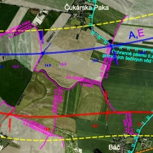
Keďže vzťah medzi pozemkovými úpravami a územným plánovaním môže mať značný význam pre ich ďalšie smerovanie, pripájam niekoľko ďalších postrehov k predchádzajúcemu príspevku.
PÚ vs. ÚP. Koordinácia namiesto súperenia
17.4.2016 8:36 Komora pozemkových úprav SR Keďže vzťah medzi pozemkovými úpravami a územným plánovaním môže mať značný význam pre ich ďalšie smerovanie, pripájam niekoľko ďalších postrehov k predchádzajúcemu príspevku.V souvislosti s uzavřením smlo
14.4.2016 12:00 Plzeňský kraj V souvislosti s uzavřením smlouvy o dílo Mapování vybraných území pro Digitální technickou mapu Plzeňského kraje 2016 (http://www.plzensky-kraj.cz/cs/clanek/doplneni-ucelove-mapy-povrchove-situace-digitalni-technicke-mapy-plzenskeho-kraje-2016) byl aktualizován obsah mapové služby Přehled zakázek a stav doplnění Účelové mapy povrchové situace. (http://mapy.kr-plzensky.cz/gis/dtm_zakazky) V mapové službě jsou doplněny nově mapované lokality.V souvislosti s uzavřením smlo
14.4.2016 12:00 Plzeňský kraj V souvislosti s uzavřením smlouvy o dílo Mapování vybraných území pro Digitální technickou mapu Plzeňského kraje 2016 byl aktualizován obsah mapové služby Přehled zakázek a stav doplnění Účelové mapy povrchové situace. V mapové službě jsou doplněny nově mapované lokality.Přihlašte se do dalšího ročníku ESNC 2016
14.4.2016 7:00 Česká asociace pro geoinformace Využívá váš projekt systémy družicové navigace? Zkuste jej přihlásit do aktuálního ročníku soutěže ESNC 2016. Přihlásit se může téměř kdokoli: soukromé firmy, zapálení jednotlivci, studenti či čerství absolventi vysokých škol, výzkumné týmy apod. Návrh se může nacházet ve fázi pouhé ideje, rozvinutého systémového řešení či prototypu v libovolnéProgramové vyhlásenie vlády SR 2016-2020
13.4.2016 14:41 Komora pozemkových úprav SR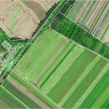
Tlačové agentúry dnes priniesli programové vyhlásenie vlády, ktoré premiér Fico predložil na rokovanie vlády. Je v ňom aj zmienka o pozemkovom vlastníctve.
Programové vyhlásenie vlády SR 2016-2020
13.4.2016 14:41 Komora pozemkových úprav SR Tlačové agentúry dnes priniesli programové vyhlásenie vlády, ktoré premiér Fico predložil na rokovanie vlády. Je v ňom aj zmienka o pozemkovom vlastníctve.Územné plánovanie, pozemkové úpravy a SQLé príležitosti
13.4.2016 14:38 Komora pozemkových úprav SR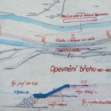
Územný plán nerieši vlastnícke vzťahy a nemá jednoznačnú formálnu a topologickú štruktúru tak, ako sú definované grafické a písomné údaje v projektoch pozemkových úprav a v údajoch katastra nehnuteľností. Myslím, že nastala doba, aby sa to zmenilo....
Územné plánovanie, pozemkové úpravy a SQLé príležitosti
13.4.2016 14:38 Komora pozemkových úprav SR Územný plán nerieši vlastnícke vzťahy a nemá jednoznačnú formálnu a topologickú štruktúru tak, ako sú definované grafické a písomné údaje v projektoch pozemkových úprav a v údajoch katastra nehnuteľností. Myslím, že nastala doba, aby sa to zmenilo.Hexagon Safety & Infrastructure Partners with TomTom to Optimize Emergency Response in the Asia-Pacific Region
13.4.2016 10:00 Hexagon Safety & InfrastructureHexagon Safety & Infrastructure will provide map and traffic data from TomTom as part of Hexagon’s public safety solutions in the Asia-Pacific region. Through a licensing agreement with TomTom Global Content B.V., Hexagon will include TomTom’s full mapping and traffic content with Hexagon’s industry-leading incident management software, Intergraph Computer-Aided Dispatch (I/CAD), to help optimize emergency response performance in a dozen countries, including Australia, India and South Korea.
TomTom’s global road network database integrates turn-by-turn directions and road data, including signage, intersections and congestions, in real time. This results in more up-to-date and precise address points, street networks and routing. Hexagon’s I/CAD features complete, integrated capabilities for call handling and dispatching, intelligent mapping, field communications, data reporting and analysis and application integration -- providing a common operating picture for intelligent response. Combining I/CAD with TomTom’s data can help increase dispatching accuracy and reduce response times to incidents and emergencies in the countries served under the agreement.
“We look forward to leveraging our partnership with TomTom to benefit dispatchers and first responders and drive additional value within our public safety solutions, raising both the performance and productivity of public safety and security agencies throughout the Asia-Pacific region,” said Mike Creevey, country manager, Australia, Hexagon Safety & Infrastructure.
As an official reseller of TomTom’s content under the agreement, Hexagon can advertise, distribute and promote TomTom’s map and traffic data, which is fully integrated into I/CAD, in Australia, Brunei, Hong Kong, India, Indonesia, Republic of Korea, Malaysia, New Zealand, Philippines, Singapore, Thailand and Vietnam.
“We are excited that Hexagon Safety & Infrastructure has selected TomTom to help provide real-time maps and traffic data for Hexagon’s leading I/CAD software,” said Phil Allen, general manager, licensing, South East Asia and Oceania, TomTom, “We are confident that TomTom’s content will contribute to improved response times during critical situations.”
TomTom is a global leader in navigation and mapping products. The company’s global map database covers more than 46 million kilometers and more than 4 billion people worldwide and features full navigable coverage for 135 countries. TomTom’s map-based components include map content, online map-based services, real-time traffic and navigation software.
The global leader in public safety and security solutions, Hexagon Safety & Infrastructure helps protect 1 in 12 people worldwide. By improving the quality, accuracy and availability of critical information, Hexagon’s integrated solutions increase public safety and security performance and productivity, while reducing the total cost of ownership for mission-critical IT investments.
Hexagon Safety & Infrastructure Partners with TomTom to Optimize Emergency Response in the Asia-Pacific Region
13.4.2016 10:00 Hexagon Safety & InfrastructureHexagon Safety & Infrastructure will provide map and traffic data from TomTom as part of Hexagon’s public safety solutions in the Asia-Pacific region. Through a licensing agreement with TomTom Global Content B.V., Hexagon will include TomTom’s full mapping and traffic content with Hexagon’s industry-leading incident management software, Intergraph Computer-Aided Dispatch (I/CAD), to help optimize emergency response performance in a dozen countries, including Australia, India and South Korea.
TomTom’s global road network database integrates turn-by-turn directions and road data, including signage, intersections and congestions, in real time. This results in more up-to-date and precise address points, street networks and routing. Hexagon’s I/CAD features complete, integrated capabilities for call handling and dispatching, intelligent mapping, field communications, data reporting and analysis and application integration -- providing a common operating picture for intelligent response. Combining I/CAD with TomTom’s data can help increase dispatching accuracy and reduce response times to incidents and emergencies in the countries served under the agreement.
“We look forward to leveraging our partnership with TomTom to benefit dispatchers and first responders and drive additional value within our public safety solutions, raising both the performance and productivity of public safety and security agencies throughout the Asia-Pacific region,” said Mike Creevey, country manager, Australia, Hexagon Safety & Infrastructure.
As an official reseller of TomTom’s content under the agreement, Hexagon can advertise, distribute and promote TomTom’s map and traffic data, which is fully integrated into I/CAD, in Australia, Brunei, Hong Kong, India, Indonesia, Republic of Korea, Malaysia, New Zealand, Philippines, Singapore, Thailand and Vietnam.
“We are excited that Hexagon Safety & Infrastructure has selected TomTom to help provide real-time maps and traffic data for Hexagon’s leading I/CAD software,” said Phil Allen, general manager, licensing, South East Asia and Oceania, TomTom, “We are confident that TomTom’s content will contribute to improved response times during critical situations.”
TomTom is a global leader in navigation and mapping products. The company’s global map database covers more than 46 million kilometers and more than 4 billion people worldwide and features full navigable coverage for 135 countries. TomTom’s map-based components include map content, online map-based services, real-time traffic and navigation software.
The global leader in public safety and security solutions, Hexagon Safety & Infrastructure helps protect 1 in 12 people worldwide. By improving the quality, accuracy and availability of critical information, Hexagon’s integrated solutions increase public safety and security performance and productivity, while reducing the total cost of ownership for mission-critical IT investments.
Vyjadrenie novej ministerky pôdohospodárstva na tému pozemkového vlastníctva
13.4.2016 9:29 Komora pozemkových úprav SR
Podľa Gabriely Matečnej sú ROEP-y na území SR ukončené na 97%, avšak ...
Vyjadrenie novej ministerky pôdohospodárstva na tému pozemkového vlastníctva
13.4.2016 9:29 Komora pozemkových úprav SR Podľa Gabriely Matečnej sú ROEP-y na území SR ukončené na 97%, avšak ...Manifest Náš stát, naše data má již více než 160 podporovatelů
11.4.2016 15:12 Otevřená data Podpora manifestu Náš stát, naše data stoupá a k iniciativě se přidalo víc než 160 jednotlivců, zástupců veřejného sektoru, neziskových organizací a komerčních subjektů, kteří v otevřených datech vidí cestu k efektivnějšímu fungování úřadů a kvalitnějším službám pro občany.Manifest Náš stát, naše data má již více než 160 podporovatelů
11.4.2016 15:12 Otevřená data Podpora manifestu Náš stát, naše data stoupá a k iniciativě se přidalo víc než 160 jednotlivců, zástupců veřejného sektoru, neziskových organizací a komerčních subjektů, kteří v otevřených datech vidí cestu k efektivnějšímu fungování úřadů a kvalitnějším službám pro občany.Byla dokončena migrace dat ÚAP
11.4.2016 12:00 Ústecký kraj Byla dokončena migrace dat ÚAP do nového datového modelu DM 3.4. ÚAP. Od 11.4.2016 jsou opět v provozu služby pro výdej dat územně analytických podkladů a služby pro aktualizaci dat.V seznamu mapových služeb obla
11.4.2016 12:00 Plzeňský kraj V seznamu mapových služeb oblasti Doprava a silniční hospodářství byl aktualizován obsah mapové služby Stavební akce na silnicích PK v letech 2015 a 2016. Nově byla doplněna vrstva stavebních akcí financovaných z rozpočtu Správy a údržby silnic Plzeňského kraje 2016. Údaje o jednotlivých akcích aktualizuje Správa a údržba silnic Plzeňského kraje. Aplikace je optimalizovaná pro používání v mobilních zařízeních.V seznamu mapových služeb obla
11.4.2016 12:00 Plzeňský kraj V seznamu mapových služeb oblasti Doprava a silniční hospodářství (http://geoportal.plzensky-kraj.cz/gs/doprava-a-silnicni-hospodastvi//) byl aktualizován obsah mapové služby Stavební akce na silnicích PK v letech 2015 a 2016 (http://tinyurl.com/qcozxw6). Nově byla doplněna vrstva stavebních akcí financovaných z rozpočtu Správy a údržby silnic Plzeňského kraje 2016. Údaje o jednotlivých akcích aktualizuje Správa a údržba silnic Plzeňského kraje. Aplikace je optimalizovaná pro používání v mobilních zařízeních.Ministerstvo financí otevřelo aplikaci Supervizor i výroční zprávu o otevřených datech
8.4.2016 12:08 Otevřená data Ministerstvo financí včera vydalo výroční zprávu k projektu otevřená data, ve které představilo cíle a vize pro nadcházející období i úspěchy, které v roce 2015 dosáhlo. Jedním z nich je aplikace Supervizor, ke které zveřejnilo zdrojový kód a poskytlo ho tak k volnému užití a vylepšování jiným státním institucím, samosprávním celkům i veřejnosti.Ministerstvo financí otevřelo aplikaci Supervizor i výroční zprávu o otevřených datech
8.4.2016 12:08 Otevřená data Ministerstvo financí včera vydalo výroční zprávu k projektu otevřená data, ve které představilo cíle a vize pro nadcházející období i úspěchy, které v roce 2015 dosáhlo. Jedním z nich je aplikace Supervizor, ke které zveřejnilo zdrojový kód a poskytlo ho tak k volnému užití a vylepšování jiným státním institucím, samosprávním celkům i veřejnosti.Aplikace Územní plány obcí a Majetek města převedeny do JavaScriptu
8.4.2016 8:55 Statutární město Ústí nad Labem Oddělení GIS převedlo další dvě mapové aplikace do jazyka JavaScript. Příprava aplikací probíhala v prostředí Web AppBuilder for ArcGIS (Developer Edition). Uživatelům jsou tak vedle již dříve publikovaného Územního plánu Ústí nad Labem tyto aplikace k dispozici i na mobilních zařízeních a nově přinášejí např. vylepšené propojení s Google StreetView, rychlejší běh, modernější vzhled a přehlednější uspořádání.Potenciální ohroženost orné půdy větrnou erozí
8.4.2016 2:00 Cenia - Katalog metadat ČR - INSPIRE Mapa potenciálního ohrožení orné půdy větrnou erozí, mapa velkého měřítka.Faktor ochranného vlivu vegetace (C)
8.4.2016 2:00 Cenia - Katalog metadat ČR - INSPIRE Mapa faktoru ochranného vlivu vegetace (C) dle klimatických regionů.Přípustná ztráta půdy (Gp)
8.4.2016 2:00 Cenia - Katalog metadat ČR - INSPIRE Mapa přípustné ztráty půdy na základě hloubky půdy.Faktor erodovatelnosti půdy (K)
8.4.2016 2:00 Cenia - Katalog metadat ČR - INSPIRE Mapa faktoru erodovatelnosti půd (K).Maximální přípustná hodnota faktoru ochranného vlivu vegetace (Cp) - nástroj ochrany zemědělské půdy proti vodní erozi
8.4.2016 2:00 Cenia - Katalog metadat ČR - INSPIRE Mapa maximálních přípustných hodnot faktoru ochranného vlivu vegetace (Cp).Základní ceny zemědělských pozemků podle BPEJ
8.4.2016 2:00 Cenia - Katalog metadat ČR - INSPIRE Vrstva základních cen zemědělských pozemků dle BPEJPotenciální ohroženost ZPF větrnou erozí
8.4.2016 2:00 Cenia - Katalog metadat ČR - INSPIRE Mapa potenciálního ohrožení zemědělského půdního fondu větrnou erozí.Projekt pozemkových úprav Ostrá Lúka
7.4.2016 18:57 Komora pozemkových úprav SR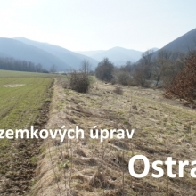
Propagačný materiál projektu pozemkových úprav.
Projekt pozemkových úprav Ostrá Lúka
7.4.2016 18:57 Komora pozemkových úprav SR Propagačný materiál projektu pozemkových úprav.Výkresy Zásad územního rozvoje
7.4.2016 12:00 Jihočeský kraj Výkresy Zásad územního rozvoje jsou nyní dostupné také ve formě interaktivní mapové aplikace umožňující identifikaci jevů nebo vyhledávání parcel. Kromě toho je možné výkresy použít také jako podkladovou mapu při prohlížení územně plánovacích dokumentací obcí.Kansas City Police Department Selects Hexagon Safety & Infrastructure Software
7.4.2016 10:00 Hexagon Safety & InfrastructureThe Kansas City, Missouri, Police Department has selected an integrated suite of public safety software from Hexagon Safety & Infrastructure for use in its communications center and police vehicles. The dispatching and mobile solution will aid police in managing incidents and emergencies and serves as the first step toward the creation of a regional dispatch system.
Replacing a legacy system, the Hexagon solution will help modernize the technology foundation that enables Kansas City Police Department operations. Its scalability and ease of integration will also aid the department’s efforts to connect its IT systems with neighboring jurisdictions, including Overland Park and Johnson County, Kansas (also Hexagon customers), for seamless regional dispatching.
“Hexagon’s proven solution provides us with a highly adaptable system, configurable to meet our needs and workflows,” said Director of Information Services Mike Grigsby, Kansas City Police Department. “With Hexagon’s dispatching and mobile software, we are positioned to expand our service offerings through interoperable regional solutions.”
The police department’s solution features Hexagon’s industry-leading incident management software, Intergraph Computer-Aided Dispatch (I/CAD), which will be used at the department’s primary dispatch center and remote back-up facility. The suite includes Mobile for Public Safety, a powerful in-vehicle application, which will be used by all field officers. The agency’s new system also features EdgeFrontier, an integration platform that will enable it to quickly build new interfaces to other dispatch and IT systems without the associated costs of custom development.
“Hexagon’s solution will help the Kansas City Police Department meet its current and future goals, from more efficient incident management to regional interoperability,” said Hank DiPietro, vice president and general manager, U.S. public safety, Hexagon Safety & Infrastructure. “Kansas City will benefit from the same robust system that serves New York City, Boston and many other major metro areas.”
The global leader in public safety and security, Hexagon Safety & Infrastructure helps protect 1 in 12 people worldwide. Hexagon’s public safety and security solutions improve the quality, accuracy and availability of critical information, increasing performance and productivity, while reducing the total cost of ownership for mission-critical IT investments.
Kansas City Police Department Selects Hexagon Safety & Infrastructure Software
7.4.2016 10:00 Hexagon Safety & InfrastructureThe Kansas City, Missouri, Police Department has selected an integrated suite of public safety software from Hexagon Safety & Infrastructure for use in its communications center and police vehicles. The dispatching and mobile solution will aid police in managing incidents and emergencies and serves as the first step toward the creation of a regional dispatch system.
Replacing a legacy system, the Hexagon solution will help modernize the technology foundation that enables Kansas City Police Department operations. Its scalability and ease of integration will also aid the department’s efforts to connect its IT systems with neighboring jurisdictions, including Overland Park and Johnson County, Kansas (also Hexagon customers), for seamless regional dispatching.
“Hexagon’s proven solution provides us with a highly adaptable system, configurable to meet our needs and workflows,” said Director of Information Services Mike Grigsby, Kansas City Police Department. “With Hexagon’s dispatching and mobile software, we are positioned to expand our service offerings through interoperable regional solutions.”
The police department’s solution features Hexagon’s industry-leading incident management software, Intergraph Computer-Aided Dispatch (I/CAD), which will be used at the department’s primary dispatch center and remote back-up facility. The suite includes Mobile for Public Safety, a powerful in-vehicle application, which will be used by all field officers. The agency’s new system also features EdgeFrontier, an integration platform that will enable it to quickly build new interfaces to other dispatch and IT systems without the associated costs of custom development.
“Hexagon’s solution will help the Kansas City Police Department meet its current and future goals, from more efficient incident management to regional interoperability,” said Hank DiPietro, vice president and general manager, U.S. public safety, Hexagon Safety & Infrastructure. “Kansas City will benefit from the same robust system that serves New York City, Boston and many other major metro areas.”
The global leader in public safety and security, Hexagon Safety & Infrastructure helps protect 1 in 12 people worldwide. Hexagon’s public safety and security solutions improve the quality, accuracy and availability of critical information, increasing performance and productivity, while reducing the total cost of ownership for mission-critical IT investments.
Máte nápad jak hacknout dopravní data? Přihlašte se na Mobility OpenData Idea Hack
6.4.2016 13:50 Otevřená data Mobilita hýbe Evropou! Souhlasíte s tímto tvrzením? Jste zástupci samosprávy, dopravní poskytovatelé, vývojáři, nebo aktivní občané s nápadem jak využít otevřená data a zlepšit tak situaci s mobilitou doma či v Evropě? Přihlaste se na Mobility OpenData Idea Hack!Na stránkách Českého statistic
6.4.2016 12:00 Plzeňský kraj Na stránkách Českého statistického úřadu byl zveřejněn nový Statistický bulletin Plzeňského kraje za 1. až 4. čtvrtletí 2015 (https://www.czso.cz/csu/czso/statisticky-bulletin-plzensky-kraj-4-ctvrtleti-2015).Na stránkách Českého statistic
6.4.2016 12:00 Plzeňský kraj Na stránkách Českého statistického úřadu byl zveřejněn nový Statistický bulletin Plzeňského kraje za 1. až 4. čtvrtletí 2015.Pozvánka na seminář projektu ELF
6.4.2016 7:00 Česká asociace pro geoinformaceČlenské schůzi CAGI, která se uskuteční v úterý 19. dubna 2016, bude předcházet seminář evropského projektu European Location Framework, jehož řešitelem za ČR je ČÚZK. Místo konání semináře a členské schůze: budova ČÚZK - konferenční sál v 6.patře, Pod sídlištěm 1800/9, Praha 8 – Kobylisy.
Program:
09:00-09:45 registrace účastníků
09:45-12:45
Pozvánka na členskou schůzi CAGI
6.4.2016 7:00 Česká asociace pro geoinformaceVážení členové CAGI, dovolte mi prosím, abych Vás srdečně pozval na členskou schůzi CAGI (dříve valná hromada), která se uskuteční v úterý 19. dubna 2016 od 13:15. Místo členské schůze: budova ČÚZK - konferenční sál v 6.patře, Pod sídlištěm 1800/9, Praha 8 – Kobylisy.
Pro účast se prosím registrujte pomocí webového formuláře.
Veškeré informace
Pure Force Deploys Hexagon Safety & Infrastructure Software in 30 Cities in Philippines
5.4.2016 10:00 Hexagon Safety & InfrastructurePure Force and Rescue Corporation has deployed a nationwide emergency call app and coordinated emergency dispatching system, built upon Hexagon Safety & Infrastructure software, across 30 cities in Philippines. The technologies help police, fire and rescue and emergency medical services agencies decrease response times and more effectively manage incidents and emergencies.
The Metro Manila Development Authority, the Philippine National Police and the Bureau of Fire Protection are among the leading agencies that have implemented the solution in partnership with Pure Force, a private initiative formed to support public safety in Philippines.
“The Hexagon software used by Pure Force will decrease and mitigate crime in the city of Manila,” said Manila Vice Mayor Francisco ‘Isko Moreno’ Domagoso. “Our citizens will sleep soundly during the night because things are being done.”
With Hexagon’s industry-leading incident management software, Intergraph Computer-Aided Dispatch (I/CAD), Pure Force’s command center benefits from a common operating picture that facilitates the sharing of critical information among agencies and in different cities across the country. Intergraph Mobile Responder, an app for smartphones and tablets, extends incident management capabilities to first responders in the field, providing access to real-time data, which improves situational awareness. In addition, members of the public can now call for help from a single emergency number or from Pure Force’s citizen mobile app irrespective of the city in which they are located.
In addition to Manila, the nation’s capital, Pure Force has also deployed the Hexagon solutions in Aklan, Butuan, Cebu city, Cebu Bogo, Cebu Consolacion, Cebu Mandaue, Caloocan, Davao, Las Piñas, Makati, Malabon, Mandaluyong, Marikina, Muntinlupa, Navotas, Parañaque, Pasay, Pasig, Pateros, Quezon city, Rodriguez Rizal, San Mateo Rizal, San Jose del Monte, San Juan, Taguig and Valenzuela.
Specializing in search and rescue operations, Pure Force is in the process of donating the mission-critical Hexagon software to every city and plans on leveraging more of Hexagon’s suite of solutions to expand its coverage nationwide. In 2015, Pure Force was presented with Hexagon Safety & Infrastructure’s Icon Award, the highest customer award, for its use of innovation to better serve its citizens and communities.
The global leader in public safety and security solutions, Hexagon Safety & Infrastructure helps protect 1 in 12 people worldwide. By improving the quality, accuracy and availability of critical information, Hexagon’s integrated solutions increase public safety and security performance and productivity, while reducing the total cost of ownership for mission-critical IT investments.
CECHG Prague 2016 - prodloužení termínu abstraktů
4.4.2016 7:00 Česká asociace pro geoinformace Termín pro podání abstraktů příspěvků na konferenci Central European Conference of Historical Geographers, která se bude konat v Praze od 31. srpna do 2. září 2016, byl prodloužen na 15. dubna! Více informací o konferenci naleznete na jejím oficiálnímJaké bylo sympozium GIS Ostrava 2016?
4.4.2016 7:00 Česká asociace pro geoinformace Obsáhlé shrnutí letošního ročníku akce GIS Ostrava 2016 si můžete přečíst v tomto dokumentu, který obsahuje mimo jiné také fotografie. Více o sympoziu naleznete také na jeho webovýchZáplavová území - Q100 (území ve správě Povodí Ohře s.p.) (jev ÚAP č. 50)
4.4.2016 2:00 Cenia - Katalog metadat ČR - INSPIRE Administrativně určené území, které může být při výskytu přirozené povodně zaplavené vodou. Jejich rozsah je povinen stanovit na návrh správce vodního toku vodoprávní úřad.POSLEDNÍ ZMĚNA 10.3.2014Opatření obecné povahy - Změna stanovení záplavového území významného vodního toku Ploučnice v ř.km 93,70 – 98,60, tj. úsek od rozdělovacího objektu Chrastná až nad obec Janův Důl, v Osečné a Janově Dole Opatření obecné povahy - Stanovení záplavového území vodního toku Oldřichovský potok v ř.km 2,261 – 3,724 v Oldřichově na Hranicích, město Hrádek nad Nisou17.3.2014Opatření obecné povahy - Změna stanovení záplavového území Šenovského potoka ř. km 0,028 – 0,180 v obci PryskZáplavová území - aktivní zóna (území ve správě Povodí Ohře s.p.) (jev ÚAP č. 51)
4.4.2016 2:00 Cenia - Katalog metadat ČR - INSPIRE Území v zastavěných územích obcí a v územích určených k zástavbě podle územního plánu, jež při povodni odvádí rozhodující část celkového průtoku a tak bezprostředně ohrožuje život, zdraví a majetek lidí. Platí zde omezení taxativně uvedená v § 67 vodního zákona. Jeho rozsah vymezuje vodoprávní úřad na základě návrhu správce toku v rámci stanovení záplavového území.POSLEDNÍ ZMĚNA 10.3.2014Opatření obecné povahy - Změna stanovení záplavového území významného vodního toku Ploučnice v ř.km 93,70 – 98,60, tj. úsek od rozdělovacího objektu Chrastná až nad obec Janův Důl, v Osečné a Janově Dole Opatření obecné povahy - Stanovení záplavového území vodního toku Oldřichovský potok v ř.km 2,261 – 3,724 v Oldřichově na Hranicích, město Hrádek nad Nisou17.3.2014Opatření obecné povahy - Změna stanovení záplavového území Šenovského potoka ř. km 0,028 – 0,180 v obci PryskPřerušení provozu DP a WSDP - 22.4. - 23.4.2016
1.4.2016 13:15 Dálkový přístup k údajům KN ČR Oznamujeme, že od 22.4.2016 od cca 14:30 hodin bude z provozních důvodu přerušen provoz Dálkového přístupu i Webových služeb dálkového přístupu. Obnovení provozu předpokládáme cca ve 12:00 hodin 23.4.2016. Za komplikace tímto způsobené se omlouváme a děkujeme za pochopení.NAŠE ŘEŠENÍ - 50 000 Kč
1.4.2016 10:00Zvažujete pořízení nového přístroje? Pokud ano, máte možnost využít naši akci na podporu obnovení přístrojového vybavení Vaší firmy. Při zakoupení totální stanice značky TOPCON OS / DS nebo SOKKIA FX / DX Vám bude odečtena částka 50 000 Kč za Váš starý funkční přístroj jakékoliv značky. Platnost nabídky je do 30.9.2016. AKČNÍ LETÁK
140 účastníků na GIVS 2016!
31.3.2016 7:00 Česká asociace pro geoinformace Do konference Geoinformace ve veřejné správě 2016 zbývá ještě více než měsíc, přesto je již konferenční sál plně obsazen. Těšíme se na Vás!Veškeré informace o konferenci včetně programu naleznete na webových stránkách
Volejbalový turnaj geodetů a kartografů
31.3.2016 7:00 Česká asociace pro geoinformaceVážení volejbaloví příznivci,
srdečně vás zvu na další ročník VOLEJBALOVÉHO TURNAJE GEODETŮ A KARTOGRAFŮ, který se letos uskuteční v sobotu 21. května 2016. Více na stránkách http://volejbal-gk2016.maestroclub.cz/. Registrace družstev byla právě spuštěna, přihlaste se už dnes :-).
Děkuji Vám za vaši přízeň! Mějte se prima a na setkání s vámi pod
Krajinné památkové zóny - bodová identifikace
31.3.2016 2:00 Cenia - Katalog metadat ČR - INSPIRE Definiční body krajinných památkových zón s připojenými základními atributy evidovanými v USKP (aplikaci Památkový katalog).Intergraph NetWorks Extends the Utility Network Model Across the Enterprise
30.3.2016 10:00 Hexagon Safety & InfrastructureHexagon Safety & Infrastructure has launched Intergraph NetWorks, a flexible software suite that provides utilities and communications companies with secure, real-time access to location-based engineering and operational data and capabilities across the enterprise. Easy to configure and powerful to use, Intergraph NetWorks unlocks value in existing geospatial investments. It enhances the reach, quality and currency of enterprise information, while improving business processes and capabilities.
Intergraph NetWorks helps address an important need for companies that manage electric, gas, telecommunications and water networks and services: the ability to exploit network information more extensively. By leveraging web services to simplify the development and maintenance of interfaces, integrations and task-oriented portal and mobile applications, Intergraph NetWorks connects the enterprise to the Intergraph G/Technology network model, making it available and usable wherever needed -- by planners, call center staff, operations center personnel, field crews and even customers.
“Intergraph NetWorks greatly increases the value businesses can derive from existing geospatial investments. It extends their reach beyond the core users – making the network model more accessible and more useable,” said Dan Retzer, senior vice president of global product development, Hexagon Safety & Infrastructure. “With access to this information, companies can improve business agility, making more informed, quicker decisions. They can better adapt to changing needs and requirements. Notably, this also helps reduce costs, errors and delays in maintaining and sharing data, improving productivity for both IT and operational tasks.”
Intergraph NetWorks leverages the network model and business rules established in Intergraph G/Technology, a product suite that enables operators to maintain a definitive source of reliable, location-based information describing their facility network and its connectivity. Intergraph NetWorks establishes a foundation of standards-based web services that provide the widest range of users and software to access, visualize, update and add network data. It offers far greater flexibility and choice than web mapping and mobile GIS tools in how data and functionality are accessed and deployed and provides a range of critical enterprise capabilities out-of-the-box. By connecting users across the enterprise with the network model and supporting new applications, Intergraph NetWorks increases the value of network data, while reducing costs.
The product suite includes Intergraph NetWorks Portal and Intergraph NetWorks Mobile. Intergraph NetWorks Portal quickly configures and deploys websites that combine reliable and up-to-date network engineering and operational information with rich capabilities, giving users the ability to browse, visualize, analyze, update and add network data. Through a configurable and easy-to-use interface, Intergraph NetWorks Portal provides a more complete information picture that is specific to business functions and users across the enterprise and beyond.
Intergraph NetWorks Mobile deploys task-oriented apps on consumer mobile devices that securely connect the field to current and authoritative network information. With tools that are more usable by more personnel, Intergraph NetWorks Mobile improves adoption rates and reduces the total cost of ownership for field solutions by leveraging the ubiquity of consumer mobile platforms. Intergraph NetWorks and Intergraph NetWorks Portal are available now, while Intergraph NetWorks Mobile will be available in mid-2016.
Hexagon Safety & Infrastructure helps utilities and communications companies achieve greater reliability, enhance customer satisfaction, increase efficiency and fulfill the expectations of customers, shareholders and regulators. A pioneer in the development and application of location-based technology, Hexagon Safety & Infrastructure provides solutions to hundreds of utilities and communications customers around the globe, supporting network engineering, network operations, customer services, sales and marketing and physical security.
Intergraph NetWorks Extends the Utility Network Model Across the Enterprise
30.3.2016 10:00 Hexagon Safety & InfrastructureHexagon Safety & Infrastructure has launched Intergraph NetWorks, a flexible software suite that provides utilities and communications companies with secure, real-time access to location-based engineering and operational data and capabilities across the enterprise. Easy to configure and powerful to use, Intergraph NetWorks unlocks value in existing geospatial investments. It enhances the reach, quality and currency of enterprise information, while improving business processes and capabilities.
Intergraph NetWorks helps address an important need for companies that manage electric, gas, telecommunications and water networks and services: the ability to exploit network information more extensively. By leveraging web services to simplify the development and maintenance of interfaces, integrations and task-oriented portal and mobile applications, Intergraph NetWorks connects the enterprise to the Intergraph G/Technology network model, making it available and usable wherever needed -- by planners, call center staff, operations center personnel, field crews and even customers.
“Intergraph NetWorks greatly increases the value businesses can derive from existing geospatial investments. It extends their reach beyond the core users – making the network model more accessible and more useable,” said Dan Retzer, senior vice president of global product development, Hexagon Safety & Infrastructure. “With access to this information, companies can improve business agility, making more informed, quicker decisions. They can better adapt to changing needs and requirements. Notably, this also helps reduce costs, errors and delays in maintaining and sharing data, improving productivity for both IT and operational tasks.”
Intergraph NetWorks leverages the network model and business rules established in Intergraph G/Technology, a product suite that enables operators to maintain a definitive source of reliable, location-based information describing their facility network and its connectivity. Intergraph NetWorks establishes a foundation of standards-based web services that provide the widest range of users and software to access, visualize, update and add network data. It offers far greater flexibility and choice than web mapping and mobile GIS tools in how data and functionality are accessed and deployed and provides a range of critical enterprise capabilities out-of-the-box. By connecting users across the enterprise with the network model and supporting new applications, Intergraph NetWorks increases the value of network data, while reducing costs.
The product suite includes Intergraph NetWorks Portal and Intergraph NetWorks Mobile. Intergraph NetWorks Portal quickly configures and deploys websites that combine reliable and up-to-date network engineering and operational information with rich capabilities, giving users the ability to browse, visualize, analyze, update and add network data. Through a configurable and easy-to-use interface, Intergraph NetWorks Portal provides a more complete information picture that is specific to business functions and users across the enterprise and beyond.
Intergraph NetWorks Mobile deploys task-oriented apps on consumer mobile devices that securely connect the field to current and authoritative network information. With tools that are more usable by more personnel, Intergraph NetWorks Mobile improves adoption rates and reduces the total cost of ownership for field solutions by leveraging the ubiquity of consumer mobile platforms. Intergraph NetWorks and Intergraph NetWorks Portal are available now, while Intergraph NetWorks Mobile will be available in mid-2016.
Hexagon Safety & Infrastructure helps utilities and communications companies achieve greater reliability, enhance customer satisfaction, increase efficiency and fulfill the expectations of customers, shareholders and regulators. A pioneer in the development and application of location-based technology, Hexagon Safety & Infrastructure provides solutions to hundreds of utilities and communications customers around the globe, supporting network engineering, network operations, customer services, sales and marketing and physical security.
Poprvé v geodézii. Rozhovor s Janem Floriánkem
29.3.2016 20:46 GeoBusinessJan Floriánek nastoupil do firmy Hrdlička hned po absolvování oboru Geodézie a kartografie na Stavební fakultě ČVUT v Praze. Po dvaceti letech práce mu Martin Hrdlička, majitel stejnojmenné firmy se…
The post Poprvé v geodézii. Rozhovor s Janem Floriánkem appeared first on GeoBusiness.
Poprvé v geodézii. Rozhovor s Janem Floriánkem
29.3.2016 20:46 GeoBusiness Jan Floriánek nastoupil do firmy Hrdlička hned po absolvování oboru Geodézie a kartografie na Stavební fakultě ČVUT v Praze. Po dvaceti letech práce mu Martin Hrdlička, majitel stejnojmenné firmy se…Poprvé v geodézii. Rozhovor s Janem Floriánkem
29.3.2016 20:46 GeoBusiness Jan Floriánek nastoupil do firmy Hrdlička hned po absolvování oboru Geodézie a kartografie na Stavební fakultě ČVUT v Praze. Po dvaceti letech práce mu Martin Hrdlička, majitel stejnojmenné firmy se…GISáček 2016 - výsledky
28.3.2016 7:00 Česká asociace pro geoinformace Tradiční soutěž studentských prací GISáček zná své vítěze! Výsledky letošního ročníku stejně jako fotografie z akce naleznete na webuOtevřená data veřejné správy pomáhají byznysu i výzkumu
26.3.2016 21:49 Různé Veřejné informace bude možné využívat i pro komerční využití„Veřejná správa disponuje řadou publikovatelných informací, které je možné využít v rámci podnikatelské činnosti,“ uvedl pro HN Petr Mlsna, náměstek ministra vnitra pro řízení sekce legislativy a archivnictví.
Nově bylo uveřejněno cca 30 da
24.3.2016 12:00 Plzeňský kraj Nově bylo uveřejněno cca 30 dalších územně plánovacích dokumentací obcí a jejich změn formou mapových služeb. Vyhledat příslušnou územně plánovací dokumentaci můžete v sekci Územní plánování » Obce v kraji » Územní plány a další nástroje územního plánování (http://geoportal.plzensky-kraj.cz/gs/uzemni-plany-a-dalsi-nastroje-uzemniho-planovani/). Nově jsou například uveřejněny dokumentace těchto obcí: Bor, Bukovec, Horní Lukavice, Horská Kvilda, Hostouň, Chlum (Rokycany), Klabava, Kočov, Kovčín, Lhota pod Radčem, Lisov, Manětín, Merklín, Mešno, Mirošov, Mnichov, Nemanice, Němčice, Nová Ves (Domažlice), Pačejov, Pasečnice, Těškov, Trhanov, Ves Touškov, Všekary a Zahrádka a řada změna a územních studií. Nově jsou k dispozici i skenované dokumentace obcí: Krašovice, Lochousice, Třemošná, Stříbro, Přestavlky, Trnová a Nebílovy.Nově bylo uveřejněno cca 30 da
24.3.2016 12:00 Plzeňský kraj Nově bylo uveřejněno cca 30 dalších územně plánovacích dokumentací obcí a jejich změn formou mapových služeb. Vyhledat příslušnou územně plánovací dokumentaci můžete v sekci Územní plánování » Obce v kraji » Územní plány a další nástroje územního plánování. Nově jsou například uveřejněny dokumentace těchto obcí: Bor, Bukovec, Horní Lukavice, Horská Kvilda, Hostouň, Chlum (Rokycany), Klabava, Kočov, Kovčín, Lhota pod Radčem, Lisov, Manětín, Merklín, Mešno, Mirošov, Mnichov, Nemanice, Němčice, Nová Ves (Domažlice), Pačejov, Pasečnice, Těškov, Trhanov, Ves Touškov, Všekary a Zahrádka a řada změna a územních studií. Nově jsou k dispozici i skenované dokumentace obcí: Krašovice, Lochousice, Třemošná, Stříbro, Přestavlky, Trnová a Nebílovy.GIVS 2016 - poslední volná místa
23.3.2016 7:00 Česká asociace pro geoinformace Posledních 10 volných míst zbývá na letošní ročník konference Geoinformace ve veřejné správě! Pokud se chcete akce zúčastnit a ještě nejste přihlášeni, už není na co čekat...Přihlásit se můžete prostřednictvím webového
Naše pole působnosti se rozšiřuje
22.3.2016 13:42 CEDA Maps a.s. Praha, 21. března 2016 - Společnost CEDA rozšiřuje portfolio stávajících služeb o dva nové produkty - vytvoření virtuální prohlídky Street View a implementaci systémů INDOOR lokalizačních a navigačních služeb.Australian Motoring Clubs Select Hexagon Safety & Infrastructure for Shared, Cloud Platform for Roadside Assistance
22.3.2016 9:00 Hexagon Safety & InfrastructureA consortium of Australian motoring clubs serving 2.8 million customers has selected Hexagon Safety & Infrastructure to provide a cloud-based platform for roadside assistance. With the selection of Hexagon’s Intergraph Computer-Aided Dispatch (I/CAD) software, the participating clubs will benefit, for the first time, from shared roadside assistance technologies.
Comprised of Royal Automobile Club of Queensland, Royal Automobile Club of Western Australia and Royal Automobile Association of South Australia, the Australian Club Consortium (ACC) was formed to promote inter-club collaboration and shared IT platforms and services. The consortium’s Common Australian Roadside Assistance System (CARS) program was initiated to deliver a common roadside assistance platform.
Glenn Toms, chairman of the CARS program steering committee and director of ACC, said, “We deliver world class service to our members, and we are broadening our membership proposition by implementing a common technology layer to support future initiatives. The I/CAD solution is built on global technology, and advances in that technology will be made available to us from across the globe. This puts us in a strong position to meet rapidly changing trends and innovation in the automotive industry.”
Roadside assistance services contribute to safer and less congested roads by aiding stranded motorists and clearing blockages and potential hazards. The participating clubs have always worked to deliver efficient and quality service to their members. They want to ensure they keep pace with the rapid advancement of automotive technology, leverage technology innovations and deliver efficiency improvements for their businesses.
The consortium selected Hexagon for the CARS program because of the company’s technical capabilities, industry knowledge and ability to deliver a unified and powerful solution to support the clubs’ current business requirements and future goals. The Hexagon systems will enable the clubs to run multiple operations from a single solution with the flexibility of cloud infrastructure; identify the caller, location and, in most cases, automatically dispatch the closest or most relevant assistance vehicle in the area; and locate members and staff in the field geospatially in real time. The solution also supports the supply of vital spare parts, management of external service providers and expansion through new business offerings.
The specific Hexagon software selected for the CARS features I/CAD, a suite of industry-leading incident management software, including Intergraph Mobile Responder, which extends dispatch capabilities to mobile devices, and EdgeFrontier, a platform that will enable seamless integration to the clubs’ IT systems. The solution also includes software from Surefire Systems, providing for point-of-sale and inventory capability. The consortium will roll out the systems to participating clubs through 2017.
“In selecting Hexagon’s dispatch and mobile systems, the Australian Club Consortium benefits from a common platform to meet the clubs’ needs now and into the future,” said Andrew Munro, senior vice president, Asia Pacific, Hexagon Safety & Infrastructure. "Our interoperable and scalable systems, deployed in the cloud, provide the clubs with a robust and reliable solution to support millions of drivers across Australia.”
Roadside assistance solutions from Hexagon Safety and Infrastructure (formerly known as Intergraph Security, Government & Infrastructure) support some of the world’s largest automobile clubs, including one system that handles nearly 6 million calls per year.
Australian Motoring Clubs Select Hexagon Safety & Infrastructure for Shared, Cloud Platform for Roadside Assistance
22.3.2016 9:00 Hexagon Safety & InfrastructureA consortium of Australian motoring clubs serving 2.8 million customers has selected Hexagon Safety & Infrastructure to provide a cloud-based platform for roadside assistance. With the selection of Hexagon’s Intergraph Computer-Aided Dispatch (I/CAD) software, the participating clubs will benefit, for the first time, from shared roadside assistance technologies.
Comprised of Royal Automobile Club of Queensland, Royal Automobile Club of Western Australia and Royal Automobile Association of South Australia, the Australian Club Consortium (ACC) was formed to promote inter-club collaboration and shared IT platforms and services. The consortium’s Common Australian Roadside Assistance System (CARS) program was initiated to deliver a common roadside assistance platform.
Glenn Toms, chairman of the CARS program steering committee and director of ACC, said, “We deliver world class service to our members, and we are broadening our membership proposition by implementing a common technology layer to support future initiatives. The I/CAD solution is built on global technology, and advances in that technology will be made available to us from across the globe. This puts us in a strong position to meet rapidly changing trends and innovation in the automotive industry.”
Roadside assistance services contribute to safer and less congested roads by aiding stranded motorists and clearing blockages and potential hazards. The participating clubs have always worked to deliver efficient and quality service to their members. They want to ensure they keep pace with the rapid advancement of automotive technology, leverage technology innovations and deliver efficiency improvements for their businesses.
The consortium selected Hexagon for the CARS program because of the company’s technical capabilities, industry knowledge and ability to deliver a unified and powerful solution to support the clubs’ current business requirements and future goals. The Hexagon systems will enable the clubs to run multiple operations from a single solution with the flexibility of cloud infrastructure; identify the caller, location and, in most cases, automatically dispatch the closest or most relevant assistance vehicle in the area; and locate members and staff in the field geospatially in real time. The solution also supports the supply of vital spare parts, management of external service providers and expansion through new business offerings.
The specific Hexagon software selected for the CARS features I/CAD, a suite of industry-leading incident management software, including Intergraph Mobile Responder, which extends dispatch capabilities to mobile devices, and EdgeFrontier, a platform that will enable seamless integration to the clubs’ IT systems. The solution also includes software from Surefire Systems, providing for point-of-sale and inventory capability. The consortium will roll out the systems to participating clubs through 2017.
“In selecting Hexagon’s dispatch and mobile systems, the Australian Club Consortium benefits from a common platform to meet the clubs’ needs now and into the future,” said Andrew Munro, senior vice president, Asia Pacific, Hexagon Safety & Infrastructure. "Our interoperable and scalable systems, deployed in the cloud, provide the clubs with a robust and reliable solution to support millions of drivers across Australia.”
Roadside assistance solutions from Hexagon Safety and Infrastructure (formerly known as Intergraph Security, Government & Infrastructure) support some of the world’s largest automobile clubs, including one system that handles nearly 6 million calls per year.
V datech územně analytických p
21.3.2016 12:00 Plzeňský kraj V datech územně analytických podkladů Plzeňského kraje byla provedena aktualizace dat o Půdních blocích a Ekologicky významných prvcích z dat LPIS od poskytovatele Ministerstvo zemědělství (http://geoportal.plzensky-kraj.cz/gs/rss?url=http%3A%2F%2Fgeoportal.plzensky-kraj.cz%2Ftw%2Fost%2Fgp%2Fuap%2Fposkytovatele%2Findex.php%3Fframe%26ID%3D5447). Jedná se o aktualizaci volně dostupných dat z platností k 12. 3. 2016.V datech územně analytických p
21.3.2016 12:00 Plzeňský kraj V datech územně analytických podkladů Plzeňského kraje byla provedena aktualizace dat o Půdních blocích a Ekologicky významných prvcích z dat LPIS od poskytovatele Ministerstvo zemědělství. Jedná se o aktualizaci volně dostupných dat z platností k 12. 3. 2016.Evropský průzkum o výhodách opětovného využití otevřených dat
21.3.2016 10:24 Otevřená data Jste start-up, nezisková organizace, malý nebo střední podnik, případně velká společnost? Zapojte se do průzkumu o výhodách opětovného využití otevřených dat!2016
21.3.2016 8:02 ČÚZK /Urady/Cesky-urad-zememericky-a-katastralni/Casto-hledane-informace/Poskytovani-informaci-106-1999-Sb/Zverejneni-obsahu-informaci-poskytnutych-na-za-(1)/Rok2008-2013/20162016
21.3.2016 8:02 ČÚZK - předpisy a opatření Český úřad zeměměřický a katastrálnízveřejňuje obsah informace poskytnutých na žádost dle zákona č. 106/1999 Sb. za rok
2016
V části Volně dostupné datové
18.3.2016 12:00 Plzeňský kraj V části Volně dostupné datové sady bylo provedeno doplnění a aktualizace poskytovaných datových sad.V seznamu mapových služeb obla
18.3.2016 12:00 Plzeňský kraj V seznamu mapových služeb oblasti životní prostředí byla aktualizována mapová služba Ochranná pásma vodních zdrojů, která zobrazuje sjednocená data Krajského úřadu Plzeňského kraje, vodoprávních úřadů obcí s rozšířenou působností, územně analytických podkladů obcí s rozšířenou působností a DIBAVOD. Součástí dat jsou i jednotlivá rozhodnutí o stanovení pásma. Data byla aktualizována k 1. 3. 2016.V části Volně dostupné datové
18.3.2016 12:00 Plzeňský kraj V části Volně dostupné datové sady (http://geoportal.plzensky-kraj.cz/gs/volne-dostupne-datove-sady/) bylo provedeno doplnění a aktualizace poskytovaných datových sad.V seznamu mapových služeb obla
18.3.2016 12:00 Plzeňský kraj V seznamu mapových služeb oblasti životní prostředí (http://geoportal.plzensky-kraj.cz/gs/zivotni-prostredi/) byla aktualizována mapová služba Ochranná pásma vodních zdrojů (http://mapy.kr-plzensky.cz/gis/opvz/), která zobrazuje sjednocená data Krajského úřadu Plzeňského kraje, vodoprávních úřadů obcí s rozšířenou působností, územně analytických podkladů obcí s rozšířenou působností a DIBAVOD. Součástí dat jsou i jednotlivá rozhodnutí o stanovení pásma. Data byla aktualizována k 1. 3. 2016.V části Zajímavé stránky (http
17.3.2016 12:00 Plzeňský kraj V části Zajímavé stránky (http://geoportal.plzensky-kraj.cz/gs/zajimave-stranky/) byl doplněn odkaz na Veřejný registr půdy - LPIS (http://eagri.cz/public/app/lpisext/lpis/verejny/), kterým Ministerstvo zemědělství zveřejňuje v elektronické podobě způsobem umožňujícím dálkový a nepřetržitý přístup základní údaje z veřejné části evidence využití půdy.V části Zajímavé stránky byl d
17.3.2016 12:00 Plzeňský kraj V části Zajímavé stránky byl doplněn odkaz na Veřejný registr půdy - LPIS, kterým Ministerstvo zemědělství zveřejňuje v elektronické podobě způsobem umožňujícím dálkový a nepřetržitý přístup základní údaje z veřejné části evidence využití půdy.Gefos zve na školení MISYS
17.3.2016 7:00 Česká asociace pro geoinformace Společnost GEFOS, kolektivní člen CAGI, zve na školení:Vážení zákazníci,
srdečně Vás zveme na další školení MISYS, které se bude konat 26. 4. 2016 na adrese naší společnosti: Plánská 6, 370 07 České Budějovice.
Začátek školení je plánován na 9:00. Registrace účastníků bude probíhat od 8:30 ve vestibulu budovy u hlavního vchodu.
Jedná
NEW WAWE - prodloužení termínu
17.3.2016 7:00 Česká asociace pro geoinformace Organizátoři 8. ročníku mezinárodní studentské konference NEW WAVE v Praze, pořádané ve dnech 19. – 20. května 2016, prodloužili termín pro podání abstraktů na 31. března 2016.Mezinárodní geografická konference pro doktorandy a mladé výzkumníky New Wave se na Přírodovědecké fakultě UK koná již od roku 2009.
Veškeré informace o konferenci naleznete na jejích
Nová aplikace twiGIS umí bleskově zobrazit mapy i popisná data
16.3.2016 11:35 GIS FórumPro přihlášené uživatele byl v
14.3.2016 12:00 Plzeňský kraj Pro přihlášené uživatele byl vytvořen nový Georeport, který umožňuje za zvolené území získat informace o datech, která byla aktualizována od zadaného data. Tj. po zadání požadovaného území report vygeneruje seznam všech jevů pro které byly nalezeny v území prvky obsahující datum aktualizace novější než zadané datum. Jevy jsou řazeny podle identifikátoru JEV_ID. Report obsahuje základní geometrickou statistiku nalezených prvků daného jevu (počet prvků, jejich celkovou délku a plochu). Georeporty jsou dostupné přihlášeným uživatelům v části Můj portál / Georeporty.Program konference GIVS 2016
14.3.2016 7:00 Česká asociace pro geoinformacePondělí 2. května 2016
9:30 - 11:00
Registrace účastníků, káva
11:00 - 11:05
Zahájení konference
Karel Janečka
11:05 - 13:00
GeoInfoStrategie
Implementace GeoInfoStrategie
Eva Kubátová
Odborná skupina GeoInfoStrategie při CAGI – důvody vzniku a cíle
vedoucí OS
GIVS 2016 - posledních 30 míst!
14.3.2016 7:00 Česká asociace pro geoinformace Přibližně 30 posledních míst zbývá do naplnění sálu pro letošní ročník konference Geoinformace ve veřejné správě, která se koná 2. a 3. května na Novotného lávce v Praze.Pokud se chcete konference zúčastnit, neměli byste s přihláškou otálet. Pro tyto účely můžete využít webový
Gefos Leica Tour 2016
12.3.2016 7:00 Česká asociace pro geoinformaceVážení zákazníci,
srdečně Vás tímto zveme na tradiční Leica Tour 2016. Termíny konání v jednotlivých městech jsou tyto:
Po 21.3.
Út 22.3.
St 23.3.
Čt 24.3.
Út 29.3.
St 30.3.
Čt 31.3.
Pá 1.4.
Ústí nad Labem, Clarion
Karlovy Vary, hotel Dvorana
České Budějovice, Clarion (Gomel)
Praha, hotel DUO
Pardubice, hotel Zlatá Štika
Olomouc, hotel
Přerušení provozu DP a WSDP - 16.3.2016
11.3.2016 13:51 Dálkový přístup k údajům KN ČR Oznamujeme přerušení provozu Dálkového přístupu i Webových služeb dálkového přístupu. Provoz bude přerušen ve středu 16.3.2016 od 17:00 hodin. Obnovení provozu předpokládáme cca v 20:00 hodin. Za komplikace tímto způsobené se omlouváme a děkujeme za pochopení.Policejní Ferrari vs. dron. World Drone Prix v Dubaji
10.3.2016 13:23 GeoBusiness Závody Formule 1 nejspíš znáte. Ale závody dronů? V Dubaji zítra začínají. Závod se bude konat ve Skydive Dubai (Palm Drop Zone) ve dnech 11. a 12. března 2016. Ceny…Policejní Ferrari vs. dron. World Drone Prix v Dubaji
10.3.2016 13:23 GeoBusinessZávody Formule 1 nejspíš znáte. Ale závody dronů? V Dubaji zítra začínají. Závod se bude konat ve Skydive Dubai (Palm Drop Zone) ve dnech 11. a 12. března 2016. Ceny…
The post Policejní Ferrari vs. dron. World Drone Prix v Dubaji appeared first on GeoBusiness.