


![]()

zprávy
zdroje zpráv:Vrchní referent / rada v oddělení právních vztahů k nemovitostem Katastrálního pracoviště Ústí nad L
17.9.2024 12:54 ČÚZK /Urady/Katastralni-urady/Katastralni-urady/Katastralni-urad-pro-Ustecky-kraj/Uredni-deska/Oznameni-a-jina-uredni-sdeleni/Volna-mista/DMS/Vrchni-referent-rada-v-oddeleni-pravnich-vztahu-k-Vrchní referent/rada v oddělení obnovy katastrálního operátu č.4 v technickém odboru
17.9.2024 10:59 ČÚZK - volná místa Katastrální úřad pro Jihomoravský kraj technický odbor vypisuje výběrové řízení na místo Vrchní referent/rada v oddělení obnovy katastrálního operátu č.4 v technickém odboruVrchní referent/rada v oddělení obnovy katastrálního operátu č.4 v technickém odboru
17.9.2024 10:59 ČÚZK /Urady/Katastralni-urady/Katastralni-urady/Katastralni-urad-pro-Jihomoravsky-kraj/Uredni-deska/Oznameni-a-jina-uredni-sdeleni/Volna-mista/DMS/Vrchni-referent-rada-v-oddeleni-obnovy-katastr-(2)Vrchní referent/rada v oddělení obnovy katastrálního operátu č.4 v technickém odboru
17.9.2024 10:59 ČÚZK - předpisy a opatření Katastrální úřad pro Jihomoravský kraj technický odborvypisuje výběrové řízení na místo
Vrchní referent/rada v oddělení obnovy katastrálního operátu č.4 v technickém odboru
Odborný referent/vrchní referent v oddělení dokumentace KN na Katastrálním pracovišti Hustopeče
17.9.2024 10:50 ČÚZK /Urady/Katastralni-urady/Katastralni-urady/Katastralni-urad-pro-Jihomoravsky-kraj/Uredni-deska/Oznameni-a-jina-uredni-sdeleni/Volna-mista/DMS/Odborny-referent-vrchni-referent-v-oddeleni-dokumeOdborný referent/vrchní referent v oddělení dokumentace KN na Katastrálním pracovišti Hustopeče
17.9.2024 10:50 ČÚZK - volná místa Katastrální úřad pro Jihomoravský kraj Katastrální pracoviště Hustopeče vypisuje výběrové řízení na místo Odborný referent/vrchní referent v oddělení dokumentace KN na Katastrálním pracovišti HustopečeOdborný referent/vrchní referent v oddělení dokumentace KN na Katastrálním pracovišti Hustopeče
17.9.2024 10:50 ČÚZK - předpisy a opatření Katastrální úřad pro Jihomoravský kraj Katastrální pracoviště Hustopečevypisuje výběrové řízení na místo
Odborný referent/vrchní referent v oddělení dokumentace KN na Katastrálním pracovišti Hustopeče
Odborný referent v oddělení právních vztahů k nemovitostem na Katastrálním pracovišti Hodonín
17.9.2024 10:46 ČÚZK - volná místa Katastrální úřad pro Jihomoravský kraj Katastrální pracoviště Hodonín vypisuje výběrové řízení na místo Odborný referent v oddělení právních vztahů k nemovitostem na Katastrálním pracovišti HodonínOdborný referent v oddělení právních vztahů k nemovitostem na Katastrálním pracovišti Hodonín
17.9.2024 10:46 ČÚZK - předpisy a opatření Katastrální úřad pro Jihomoravský kraj Katastrální pracoviště Hodonínvypisuje výběrové řízení na místo
Odborný referent v oddělení právních vztahů k nemovitostem na Katastrálním pracovišti Hodonín
Odborný referent v oddělení právních vztahů k nemovitostem na Katastrálním pracovišti Hodonín
17.9.2024 10:46 ČÚZK /Urady/Katastralni-urady/Katastralni-urady/Katastralni-urad-pro-Jihomoravsky-kraj/Uredni-deska/Oznameni-a-jina-uredni-sdeleni/Volna-mista/DMS/Odborny-referent-v-oddeleni-pravnich-vztahu-k-nemoPřerušení dodávky elektrické energie 17.9.2024
17.9.2024 8:36 ČÚZK /Urady/Katastralni-urady/Katastralni-urady/Katastralni-urad-pro-Jihocesky-kraj/Katastralni-pracoviste/KP-Pisek/O-uradu/Aktuality/Preruseni-dodavky-elektricke-energie-17-9-2024Přerušení dodávky elektrické energie 17.9.2024
17.9.2024 8:36 ČÚZK - předpisy a opatření Český úřad zeměměřický a katastrální zveřejnil novou aktualitu: V úterý 17.9. 2024 od 10:30 hod do 14:30 hod bude v budově KP Písek, Nádražní 1988 přerušena dodávka elektrické energiez důvodu plánovaných prací na zařízení distribuční soustavy Eg.d
Geograf/ka
17.9.2024 8:35 Zeměměřický úřad Zeměměřický úřadvypisuje výběrové řízení na místo
Geograf/ka
Geograf/ka
17.9.2024 8:35 ČÚZK - předpisy a opatření Zeměměřický úřadvypisuje výběrové řízení na místo
Geograf/ka
Geograf/ka
17.9.2024 8:35 ČÚZK - volná místa Zeměměřický úřad vypisuje výběrové řízení na místo Geograf/kaGeograf/ka
17.9.2024 8:35 ČÚZK /Urady/Zememericky-urad/Uredni-deska/Oznameni-a-jina-uredni-sdeleni/Volna-mista/DMS/Geograf-ka-(1)Povodne_3
16.9.2024 17:04 ČÚZK - předpisy a opatření Katastrální úřad pro Moravskoslezský kraj zveřejnil novou aktualitu: Z důvodu povodní bude mít Katastrální pracoviště Karviná až do odvolání omezený provoz.V rozsahu úředních hodin bude zajištěn příjem podání. Svá podání můžete rovněž učinit elektronicky prostřednictvím datové schránky.
O dalším vývoji Vás budeme informovat na našich stránkách.
Děkujeme za pochopení
Povodne_3
16.9.2024 17:04 ČÚZK /Urady/Katastralni-urady/Katastralni-urady/Katastralni-urad-pro-Moravskoslezsky-kraj/O-uradu/Aktuality/Povodne_3odborný/vrchní referent – obnova katastrálního operátu v oddělení obnovy katastrálního operátu na Ka
16.9.2024 14:37 ČÚZK /Urady/Katastralni-urady/Katastralni-urady/Katastralni-urad-pro-Jihocesky-kraj/Uredni-deska/Oznameni-a-jina-uredni-sdeleni/Volna-mista/DMS/odborny-vrchni-referent-–-obnova-katastralniho-(2)odborný/vrchní referent – obnova katastrálního operátu v oddělení obnovy katastrálního operátu na Ka
16.9.2024 14:37 ČÚZK - volná místa Katastrální úřad pro Jihočeský kraj odbor obnovy katastrálního operátu vypisuje výběrové řízení na místo odborný/vrchní referent – obnova katastrálního operátu v oddělení obnovy katastrálního operátu na Kaodborný/vrchní referent – obnova katastrálního operátu v oddělení obnovy katastrálního operátu na Ka
16.9.2024 14:37 ČÚZK - předpisy a opatření Katastrální úřad pro Jihočeský kraj odbor obnovy katastrálního operátuvypisuje výběrové řízení na místo
odborný/vrchní referent – obnova katastrálního operátu v oddělení obnovy katastrálního operátu na Katastrálním úřadu pro Jihočeský kraj (ID SM 30000076/30003700)
Oznámení o vyhlášení VŘ na služební místo rada - odborný rada
16.9.2024 13:16 ČÚZK /Urady/Zememericke-a-katastralni-inspektoraty/Zememericke-a-katastralni-inspektoraty/Zememericky-a-katastralni-inspektorat-v-Praze/O-uradu/Aktuality/Oznameni-o-vyhlaseni-VR-na-sluzebni-misto-rada-(1)Oznámení o vyhlášení VŘ na služební místo rada - odborný rada
16.9.2024 13:16 ČÚZK - předpisy a opatření Zeměměřický a katastrální inspektorát v Praze zveřejnil novou aktualitu: Zeměměřický a katastrální inspektorát v Praze vyhlašuje výběrová řízení na služební místa Rada/Odborný rada inspektor (obor služby 55) .Rada/odborný rada - inspektor ZKI v Praze (obor služby 55.)
16.9.2024 13:15 ČÚZK - předpisy a opatření Zeměměřický a katastrální inspektorát v Prazevypisuje výběrové řízení na místo
Rada/odborný rada - inspektor ZKI v Praze (obor služby 55.)
Rada/odborný rada - inspektor ZKI v Praze (obor služby 55.)
16.9.2024 13:15 ČÚZK /Urady/Zememericke-a-katastralni-inspektoraty/Zememericke-a-katastralni-inspektoraty/Zememericky-a-katastralni-inspektorat-v-Praze/Uredni-deska/Oznameni-a-jina-uredni-sdeleni/Volna-mista/DMS/Rada-odborny-rada-inspektor-ZKI-v-Praze-(obor-sluzRada/odborný rada - inspektor ZKI v Praze (obor služby 55.)
16.9.2024 13:15 ČÚZK - volná místa Zeměměřický a katastrální inspektorát v Praze vypisuje výběrové řízení na místo Rada/odborný rada - inspektor ZKI v Praze (obor služby 55.)
Nové číslo GaKO
16.9.2024 12:43
ÚGKK SR
Nové číslo časopisu Geodetického a Kartografického Obzoru 09/2024
odborný/vrchní referent – obnova katastrálního operátu v oddělení obnovy katastrálního operátu 3050
16.9.2024 12:29 ČÚZK /Urady/Katastralni-urady/Katastralni-urady/Katastralni-urad-pro-Jihocesky-kraj/Uredni-deska/Oznameni-a-jina-uredni-sdeleni/Volna-mista/DMS/odborny-vrchni-referent-–-obnova-katastralniho-(1)odborný/vrchní referent – obnova katastrálního operátu v oddělení obnovy katastrálního operátu 3050
16.9.2024 12:29 ČÚZK - volná místa Katastrální úřad pro Jihočeský kraj odbor obnovy katastrálního operátu vypisuje výběrové řízení na místo odborný/vrchní referent – obnova katastrálního operátu v oddělení obnovy katastrálního operátu 3050odborný/vrchní referent – obnova katastrálního operátu v oddělení obnovy katastrálního operátu 3050
16.9.2024 12:29 ČÚZK - předpisy a opatření Katastrální úřad pro Jihočeský kraj odbor obnovy katastrálního operátuvypisuje výběrové řízení na místo
odborný/vrchní referent – obnova katastrálního operátu v oddělení obnovy katastrálního operátu 3050 na Katastrálním úřadu pro Jihočeský kraj (ID SM 30000079/30003703)
GaKO 9/2024
16.9.2024 11:08 GaKO GaKO 9/2024 SMOLÍK, K.–FERIANC, M.–BUTKOVSKÁ, S.: Slovenská priestorová observačná služba sprístupnila korekcie v koncepte najbližšej referenčnej staniceUzavření katastrálního pracoviště KP Jeseník
16.9.2024 9:10 ČÚZK - předpisy a opatření Katastrální úřad pro Olomoucký kraj - Katastrální pracoviště Jeseník zveřejnil novou aktualitu: Z důvodu povodní je do odvolání uzavřeno katastrální pracoviště Jeseník.Svá podání můžete učinit elektronicky prostřednictvím datové schránky, případně se obraťte na Katastrální pracoviště Šumperk.
Uzavření katastrálního pracoviště KP Jeseník
16.9.2024 9:10 ČÚZK /Urady/Katastralni-urady/Katastralni-urady/Katastralni-urad-pro-Olomoucky-kraj/Katastralni-pracoviste/KP-Jesenik/O-uradu/Aktuality/Uzavreni-katastralniho-pracoviste-KP-JesenikUzavření katastrálního pracoviště KP Jeseník
16.9.2024 9:05 ČÚZK /Urady/Katastralni-urady/Katastralni-urady/Katastralni-urad-pro-Olomoucky-kraj/O-uradu/Aktuality/Uzavreni-katastralniho-pracoviste-KP-JesenikUzavření katastrálního pracoviště KP Jeseník
16.9.2024 9:05 ČÚZK - předpisy a opatření Katastrální úřad pro Olomoucký kraj - Katastrální pracoviště Jeseník zveřejnil novou aktualitu: Z důvodu povodní je do odvolání uzavřeno katastrální pracoviště Jeseník.Svá podání můžete učinit elektronicky prostřednictvím datové schránky, případně se obraťte na Katastrální pracoviště Šumperk.
Program a místa 3GON Tour 2024, představující novinky v měřické technice a dronech
16.9.2024 8:38 ZeměměřičSpolečnost 3GON Positioning zve všechny geodety na své pravidelné setkání v několika městech České republiky. Od 7. do 10. října 2024 budou zástupci firmy prezentovat nejnovější technologie a postupy v oblasti geodézie3D skenování. Účastníci se mohou těšit na praktické ukázky a odpovědi na otázky týkající se měření v náročných podmínkách, využití GNSS technologií či práce s robotickými totálními stanicemi. Vstup je zdarma, registrovat se […]
The post Program a místa 3GON Tour 2024, představující novinky v měřické technice a dronech appeared first on Zeměměřič.
20240916-Dočasné uzavření KP Jeseník
16.9.2024 8:29 ČÚZK - aktuality v resortu Z důvodu povodní je do odvolání uzavřeno katastrální pracoviště Jeseník. Svá podání můžete učinit elektronicky prostřednictvím datové schránky, případně se obraťte na Katastrální pracoviště Šumperk.--
Z důvodu přerušení dodávky elektrické energie má 16. 9. 2024 výrazně omezený provoz Katastrální pracoviště Opava.
20240916-Dočasné uzavření KP Jeseník
16.9.2024 8:29 ČÚZK - aktuality v resortu Z důvodu povodní je do odvolání uzavřeno Katastrální pracoviště Jeseník a Katastrální pracoviště Krnov. Podání můžete činit elektronicky, případně se obraťte na Katastrální pracoviště Šumperk (pro případy KP Jeseník) nebo Katastrální pracoviště Bruntál (pro případy KP Krnov).--
Katastrální pracoviště Karviná a Katastrální pracoviště Opava mají obnoven úplný provoz .
20240916-Dočasné uzavření KP Jeseník
16.9.2024 8:29 ČÚZK - předpisy a opatření Český úřad zeměměřický a katastrální zveřejnil novou aktualitu: Z důvodu povodní je do odvolání uzavřeno Katastrální pracoviště Jeseník. Svá podání můžete učinit elektronicky prostřednictvím datové schránky, případně se obraťte na Katastrální pracoviště Šumperk.--
Z důvodu přerušení dodávky elektrické energie má 16. 9. 2024 výrazně omezený provoz Katastrální pracoviště Opava.
20240916-Dočasné uzavření KP Jeseník
16.9.2024 8:29 ČÚZK - předpisy a opatření Český úřad zeměměřický a katastrální zveřejnil novou aktualitu: Z důvodu povodní je do odvolání uzavřeno Katastrální pracoviště Jeseník a Katastrální pracoviště Krnov. Podání můžete činit elektronicky, případně se obraťte na Katastrální pracoviště Šumperk (pro případy KP Jeseník) nebo Katastrální pracoviště Bruntál (pro případy KP Krnov).--
Katastrální pracoviště Karviná a Katastrální pracoviště Opava mají obnoven úplný provoz .
20240916-Dočasné uzavření KP Jeseník
16.9.2024 8:29 ČÚZK - aktuality v resortu Z důvodu povodní je do odvolání uzavřeno katastrální pracoviště Jeseník a katastrální pracoviště Krnov. Podání můžete činit elektronicky, případně se obraťte na katastrální pracoviště Šumperk (pro případy KP Jeseník) nebo katastrální pracoviště Bruntál (pro případy KP Krnov).--
Katastrální pracoviště Karviná a katastrální pracoviště Opava mají obnoven úplný provoz .
20240916-Dočasné uzavření KP Jeseník
16.9.2024 8:29 ČÚZK - aktuality v resortu Z důvodu povodní je do odvolání uzavřeno Katastrální pracoviště Jeseník. Podání můžete činit elektronicky, případně se obraťte na Katastrální pracoviště Šumperk.20240916-Dočasné uzavření KP Jeseník
16.9.2024 8:29 ČÚZK - předpisy a opatření Český úřad zeměměřický a katastrální zveřejnil novou aktualitu: Z důvodu povodní je do odvolání uzavřeno katastrální pracoviště Jeseník. Svá podání můžete učinit elektronicky prostřednictvím datové schránky, případně se obraťte na Katastrální pracoviště Šumperk.--
Z důvodu přerušení dodávky elektrické energie má 16. 9. 2024 výrazně omezený provoz Katastrální pracoviště Opava.
20240916-Dočasné uzavření KP Jeseník
16.9.2024 8:29 ČÚZK - předpisy a opatření Český úřad zeměměřický a katastrální zveřejnil novou aktualitu: Z důvodu povodní je do odvolání uzavřeno katastrální pracoviště Jeseník a katastrální pracoviště Krnov. Podání můžete činit elektronicky, případně se obraťte na katastrální pracoviště Šumperk (pro případy KP Jeseník) nebo katastrální pracoviště Bruntál (pro případy KP Krnov).--
Katastrální pracoviště Karviná a katastrální pracoviště Opava mají obnoven úplný provoz .
20240916-Dočasné uzavření KP Jeseník
16.9.2024 8:29 ČÚZK - předpisy a opatření Český úřad zeměměřický a katastrální zveřejnil novou aktualitu: Z důvodu povodní je do odvolání uzavřeno Katastrální pracoviště Jeseník. Podání můžete učinit elektronicky prostřednictvím datové schránky, případně se obraťte na Katastrální pracoviště Šumperk.20240916-Dočasné uzavření KP Jeseník
16.9.2024 8:29 ČÚZK - aktuality v resortu Z důvodu povodní je do odvolání uzavřeno Katastrální pracoviště Jeseník. Svá podání můžete učinit elektronicky prostřednictvím datové schránky, případně se obraťte na Katastrální pracoviště Šumperk.--
Z důvodu přerušení dodávky elektrické energie má 16. 9. 2024 výrazně omezený provoz Katastrální pracoviště Opava.
20240916-Dočasné uzavření KP Jeseník
16.9.2024 8:29 ČÚZK - předpisy a opatření Český úřad zeměměřický a katastrální zveřejnil novou aktualitu: Z důvodu povodní je do odvolání uzavřeno Katastrální pracoviště Jeseník. Podání můžete činit elektronicky, případně se obraťte na Katastrální pracoviště Šumperk.20240916-Dočasné uzavření KP Jeseník
16.9.2024 8:29 ČÚZK /Aktuality-resort/2024/20240916-Docasne-uzavreni-KP-Jesenik20240916-Dočasné uzavření KP Jeseník
16.9.2024 8:29 ČÚZK - aktuality v resortu Z důvodu povodní je do odvolání uzavřeno Katastrální pracoviště Jeseník. Podání můžete učinit elektronicky prostřednictvím datové schránky, případně se obraťte na Katastrální pracoviště Šumperk.Z důvodu povodní je do odvolání uzavřeno Katastrální pracoviště Krnov. Podání můžete učinit elektronicky prostřednictvím datové schránky, případně se obraťte na Katastrální pracoviště Bruntál.
--
Katastrální pracoviště Karviná a katastrální pracoviště Opava mají obnoven úplný provoz .
20240916-Dočasné uzavření KP Jeseník
16.9.2024 8:29 ČÚZK - předpisy a opatření Český úřad zeměměřický a katastrální zveřejnil novou aktualitu: Z důvodu povodní jsou do odvolání uzavřena katastrální pracoviště Jeseník a Krnov. Podání můžete činit elektronicky, případně se obraťte na katastrální pracoviště Šumperk (pro případy KP Jeseník) nebo katastrální pracoviště Bruntál (pro případy KP Krnov).--
Katastrální pracoviště Karviná a katastrální pracoviště Opava mají obnoven úplný provoz .
20240916-Dočasné uzavření KP Jeseník
16.9.2024 8:29 ČÚZK - aktuality v resortu Z důvodu povodní je do odvolání uzavřeno Katastrální pracoviště Jeseník. Podání můžete učinit elektronicky prostřednictvím datové schránky, případně se obraťte na Katastrální pracoviště Šumperk.20240916-Dočasné uzavření KP Jeseník
16.9.2024 8:29 ČÚZK - předpisy a opatření Český úřad zeměměřický a katastrální zveřejnil novou aktualitu: Z důvodu povodní je do odvolání uzavřeno Katastrální pracoviště Jeseník. Podání můžete učinit elektronicky prostřednictvím datové schránky, případně se obraťte na Katastrální pracoviště Šumperk.Z důvodu povodní je do odvolání uzavřeno Katastrální pracoviště Krnov. Podání můžete učinit elektronicky prostřednictvím datové schránky, případně se obraťte na Katastrální pracoviště Bruntál.
--
Katastrální pracoviště Karviná a katastrální pracoviště Opava mají obnoven úplný provoz .
Povodně_2024_2
16.9.2024 5:55 ČÚZK /Urady/Katastralni-urady/Katastralni-urady/Katastralni-urad-pro-Moravskoslezsky-kraj/Katastralni-pracoviste/KP-Opava/O-uradu/Aktuality/Povodne_2024_2Povodně_2024_2
16.9.2024 5:55 ČÚZK - předpisy a opatření Katastrální úřad pro Moravskoslezský kraj - Katastrální pracoviště Opavazveřejnil novou aktualitu: Z důvodu přerušení dodávky elektrické energie bude dne 16. 9. 2024 výrazně omezen provoz Katastrálního pracoviště Opava.
Povodně_2024_2
16.9.2024 5:53 ČÚZK - předpisy a opatření Katastrální úřad pro Moravskoslezský krajzveřejnil novou aktualitu: Z důvodu přerušení dodávky elektrické energie bude dne 16. 9. 2024 výrazně omezen provoz Katastrálního pracoviště Opava, jakož i Katastrálního úřadu pro Moravskoslezský kraj.
Povodně_2024_2
16.9.2024 5:53 ČÚZK /Urady/Katastralni-urady/Katastralni-urady/Katastralni-urad-pro-Moravskoslezsky-kraj/O-uradu/Aktuality/Povodne_2024_220240915-Dočasné uzavření KP Krnov
15.9.2024 20:48 ČÚZK - předpisy a opatření Český úřad zeměměřický a katastrální zveřejnil novou aktualitu: Z důvodu povodní jsou do odvolání uzavřena Katastrální pracoviště Karviná a Krnov.Svá podání můžete učinit elektronicky prostřednictvím datové schránky, případně se obraťte na Katastrální pracoviště Ostrava (záležitosti KP Karviná) či na Katastrální pracoviště Bruntál (záležitosti KP Krnov).
20240915-Dočasné uzavření KP Krnov
15.9.2024 20:48 ČÚZK - aktuality v resortu Z důvodu povodní je do odvolání uzavřeno Katastrální pracoviště Krnov.Podání můžete učinit elektronicky prostřednictvím datové schránky či na Katastrální pracoviště Bruntál.
--
Aktualizace 16.9.2024:
Katastrální pracoviště Karviná má až do odvolání omezený provoz. V úředních hodinách bude zajištěn příjem podání. Podání můžete rovněž učinit elektronicky prostřednictvím datové schránky.
20240915-Dočasné uzavření KP Krnov
15.9.2024 20:48 ČÚZK - předpisy a opatření Český úřad zeměměřický a katastrální zveřejnil novou aktualitu: Z důvodu povodní je do odvolání uzavřeno Katastrální pracoviště Krnov.Podání můžete učinit elektronicky prostřednictvím datové schránky či na Katastrální pracoviště Bruntál.
--
Aktualizace 16.9.2024:
Katastrální pracoviště Karviná má až do odvolání omezený provoz. V úředních hodinách bude zajištěn příjem podání. Podání můžete rovněž učinit elektronicky prostřednictvím datové schránky.
20240915-Dočasné uzavření KP Krnov
15.9.2024 20:48 ČÚZK - předpisy a opatření Český úřad zeměměřický a katastrálnízveřejnil novou aktualitu: Z důvodu povodní je do odvolání uzavřeno katastrální pracoviště Krnov.
20240915-Dočasné uzavření KP Krnov
15.9.2024 20:48 ČÚZK /Aktuality-resort/2024/20240915-Docasne-uzavreni-KP-Krnov20240915-Dočasné uzavření KP Krnov
15.9.2024 20:48 ČÚZK - aktuality v resortu Z důvodu povodní jsou do odvolání uzavřena katastrální pracoviště Karviná a Krnov.Svá podání můžete učinit elektronicky prostřednictvím datové schránky, případně se obraťte na Katastrální pracoviště Ostrava (záležitosti KP Karviná) či na Katastrální pracoviště Bruntál (záležitosti KP Krnov).
20240915-Dočasné uzavření KP Krnov
15.9.2024 20:48 ČÚZK - předpisy a opatření Český úřad zeměměřický a katastrální zveřejnil novou aktualitu: Z důvodu povodní jsou do odvolání uzavřena katastrální pracoviště Karviná a Krnov.Svá podání můžete učinit elektronicky prostřednictvím datové schránky, případně se obraťte na Katastrální pracoviště Ostrava (záležitosti KP Karviná) či na Katastrální pracoviště Bruntál (záležitosti KP Krnov).
20240915-Dočasné uzavření KP Krnov
15.9.2024 20:48 ČÚZK - aktuality v resortu Z důvodu povodní je do odvolání uzavřeno Katastrální pracoviště Krnov.Podání můžete učinit elektronicky prostřednictvím datové schránky či na Katastrální pracoviště Bruntál.
--
Aktualizace 17.9.2024:
Katastrální pracoviště Karviná má 17.9.2024 omezený provoz. Od 18.9.2024 bude mít provoz úplný.
20240915-Dočasné uzavření KP Krnov
15.9.2024 20:48 ČÚZK - aktuality v resortu Z důvodu povodní jsou do odvolání uzavřena Katastrální pracoviště Karviná a Krnov.Svá podání můžete učinit elektronicky prostřednictvím datové schránky, případně se obraťte na Katastrální pracoviště Ostrava (záležitosti KP Karviná) či na Katastrální pracoviště Bruntál (záležitosti KP Krnov).
20240915-Dočasné uzavření KP Krnov
15.9.2024 20:48 ČÚZK - předpisy a opatření Český úřad zeměměřický a katastrální zveřejnil novou aktualitu: Z důvodu povodní je do odvolání uzavřeno Katastrální pracoviště Krnov.Podání můžete učinit elektronicky prostřednictvím datové schránky či na Katastrální pracoviště Bruntál.
--
Aktualizace 17.9.2024:
Katastrální pracoviště Karviná má 17.9.2024 omezený provoz. Od 18.9.2024 bude mít provoz úplný.
20240915-Dočasné uzavření KP Krnov
15.9.2024 20:48 ČÚZK - aktuality v resortu Z důvodu povodní je do odvolání uzavřeno katastrální pracoviště Krnov.První fáze instalace senzorové sítě úspěšně realizována
15.9.2024 20:08 Katedra geoinformatiky UP OlomoucV průběhu léta jsme se pustili do prvních fází řešení mezinárodního projektu EnCLOD. Ve spolupráci s partnery z firem CityOne a CITIQ jsme navrhnuli senzorovou síť, která bude na území města Olomouce sbírat velké množství dat, především o dopravě a teplotách. Od minulého týdně již sbíráme data z 26 dopravních sensorů určených primárně pro zkoumání […]
The post První fáze instalace senzorové sítě úspěšně realizována first appeared on Katedra geoinformatiky.
Povodně_2024
15.9.2024 19:07 ČÚZK /Urady/Katastralni-urady/Katastralni-urady/Katastralni-urad-pro-Moravskoslezsky-kraj/O-uradu/Aktuality/Povodne_2024Povodně_2024
15.9.2024 19:07 ČÚZK - předpisy a opatření Katastrální úřad pro Moravskoslezský kraj zveřejnil novou aktualitu: Z důvodu povodní je Katastrální pracoviště Krnov do odvolání pro veřejnost uzavřeno.Svá podání můžete učinit elektronicky prostřednictvím datové schránky, případně se prosím se svými požadavky obraťte na Katastrální pracoviště Bruntál.
O dalším vývoji Vás budeme informovat na našich stránkách.
Děkujeme za pochopení
Povodně_2024
15.9.2024 19:07 ČÚZK - předpisy a opatření Katastrální úřad pro Moravskoslezský kraj zveřejnil novou aktualitu: Z důvodu povodní je Katastrální pracoviště Karviná a Krnov do odvolání pro veřejnost uzavřeno.Svá podání můžete učinit elektronicky prostřednictvím datové schránky, případně se prosím se svými požadavky obraťte na Katastrální pracoviště Ostrava (záležitosti KP Karviná) či na Katastrální pracoviště Bruntál (záležitosti KP Krnov).
O dalším vývoji Vás budeme informovat na našich stránkách.
Děkujeme za pochopení
Povodně_2024
15.9.2024 19:03 ČÚZK - předpisy a opatření Katastrální úřad pro Moravskoslezský kraj - Katastrální pracoviště Krnov zveřejnil novou aktualitu: Z důvodu povodní je Katastrální pracoviště Krnov do odvolání pro veřejnost uzavřeno.Svá podání můžete učinit elektronicky prostřednictvím datové schránky, případně se prosím se svými požadavky obraťte na Katastrální pracoviště Bruntál.
O dalším vývoji Vás budeme informovat na našich stránkách.
Děkujeme za pochopení
Povodně_2024
15.9.2024 19:03 ČÚZK /Urady/Katastralni-urady/Katastralni-urady/Katastralni-urad-pro-Moravskoslezsky-kraj/Katastralni-pracoviste/KP-Krnov/O-uradu/Aktuality/Povodne_2024Povodně_2024
15.9.2024 19:00 ČÚZK - předpisy a opatření Katastrální úřad pro Moravskoslezský kraj - Katastrální pracoviště Karviná zveřejnil novou aktualitu: Z důvodu povodní bude mít Katastrální pracoviště Karviná až do odvolání omezený provoz.V rozsahu úředních hodin bude zajištěn příjem podání. Svá podání můžete rovněž učinit elektronicky prostřednictvím datové schránky.
O dalším vývoji Vás budeme informovat na našich stránkách.
Děkujeme za pochopení
Povodně_2024
15.9.2024 19:00 ČÚZK /Urady/Katastralni-urady/Katastralni-urady/Katastralni-urad-pro-Moravskoslezsky-kraj/Katastralni-pracoviste/KP-Karvina/O-uradu/Aktuality/Povodne_2024Povodně_2024
15.9.2024 19:00 ČÚZK - předpisy a opatření Katastrální úřad pro Moravskoslezský kraj - Katastrální pracoviště Karviná zveřejnil novou aktualitu: Z důvodu povodní je Katastrální pracoviště Karviná do odvolání pro veřejnost uzavřeno.Svá podání můžete učinit elektronicky prostřednictvím datové schránky, případně se prosím se svými požadavky obraťte na Katastrální pracoviště Ostrava.
O dalším vývoji Vás budeme informovat na našich stránkách.
Děkujeme za pochopení
3GONTOUR 2024 – POZVÁNKA
15.9.2024 15:38 3gon Srdečně Vás opět po roce zveme na naši 3GON Tour 2024. Jedná se o jedinečnou ukázku a workshop měřické technologiea3GONTOUR 2024 – POZVÁNKA
15.9.2024 15:38 3gon Srdečně Vás opět po roce zveme na naši 3GON Tour 2024 Jedná se o jedinečnou ukázku a workshop měřické technologiea3GONTOUR 2024 – POZVÁNKA
15.9.2024 15:38 3gon Srdečně Vás opět po roce zveme na naši 3GON Tour 2024 Jedná se o jedinečnou ukázku a workshop měřické technologie20240915-Dočasné uzavření KP Karviná
15.9.2024 14:33 ČÚZK - předpisy a opatření Český úřad zeměměřický a katastrálnízveřejnil novou aktualitu: Z důvodu zatopení je do odvolání uzavřeno katastrální pracoviště Karviná. O dalším vývoji vás budeme informovat.
20240915-Dočasné uzavření KP Karviná
15.9.2024 14:33 ČÚZK - aktuality v resortu Z důvodu zatopení je do odvolání uzavřeno katastrální pracoviště Karviná. O dalším vývoji vás budeme informovat.20240915-Dočasné uzavření KP Karviná
15.9.2024 14:33 ČÚZK /Aktuality-resort/2024/20240915-Docasne-uzavreni-KP-Karvina20240915-Dočasné uzavření KP Karviná
15.9.2024 14:33 ČÚZK - aktuality v resortu Z důvodu povodní jsou do odvolání uzavřena katastrální pracoviště Karviná a Krnov.Svá podání můžete učinit elektronicky prostřednictvím datové schránky, případně se se svými požadavky obraťte na Katastrální pracoviště Ostrava (záležitosti KP Karviná) či na Katastrální pracoviště Bruntál (záležitosti KP Krnov).
20240915-Dočasné uzavření KP Karviná
15.9.2024 14:33 ČÚZK - předpisy a opatření Český úřad zeměměřický a katastrální zveřejnil novou aktualitu: Z důvodu povodní jsou do odvolání uzavřena katastrální pracoviště Karviná a Krnov.Svá podání můžete učinit elektronicky prostřednictvím datové schránky, případně se se svými požadavky obraťte na Katastrální pracoviště Ostrava (záležitosti KP Karviná) či na Katastrální pracoviště Bruntál (záležitosti KP Krnov).
Mapy.cz zobrazují povodňová data od ČHMU
13.9.2024 12:29 GISportal.cz
Novinka, která se bude nyní hodně lidem hodit se objevila na Mapy.cz – nově můžete přidat vrstvu/mapu „Povodňová„, která ukazuje stanice ČHMU a při prokliknutí zobrazí informace o stavu, průtoku, apod. Informace jsou pravidelně aktualiziovány!
The post Mapy.cz zobrazují povodňová data od ČHMU appeared first on GISportal.cz.
Mapy.cz zobrazují povodňová data od ČHMU
13.9.2024 12:29 GISportal.czNovinka, která se bude nyní hodně lidem hodit se objevila na Mapy.cz – nově můžete přidat vrstvu/mapu „Povodňová„, která ukazuje stanice ČHMU a při prokliknutí zobrazí informace o stavu, průtoku, apod. Informace jsou pravidelně aktualiziovány!
The post Mapy.cz zobrazují povodňová data od ČHMU appeared first on GISportal.cz.
České uživatelské fórum Copernicus a Dálkový průzkum Země (registrace otevřena)
13.9.2024 12:10 GISportal.cz
Již nyní se můžete registrovat na konferenci, která se koná 4. a 5. listopadu (tedy přesně před GIS Esri konferencí) v nově zrekonstruované Fantově budově v Praze. Letos vás čeká několik zajímavých novinek. První z nich je, že se agenda programu Copernicus v ČR přesunula na Český hydrometeorologický ústav. Dále se oproti předchozím ročníkům můžete […]
The post České uživatelské fórum Copernicus a Dálkový průzkum Země (registrace otevřena) appeared first on GISportal.cz.
rada/odborný rada – rozhodování o povolení vkladu v oddělení právních vztahů k nemovitostem Katastrá
13.9.2024 10:25 ČÚZK - volná místa Katastrální úřad pro Jihočeský kraj Katastrální pracoviště Strakonice vypisuje výběrové řízení na místo rada/odborný rada – rozhodování o povolení vkladu v oddělení právních vztahů k nemovitostem Katastrárada/odborný rada – rozhodování o povolení vkladu v oddělení právních vztahů k nemovitostem Katastrá
13.9.2024 10:25 ČÚZK /Urady/Katastralni-urady/Katastralni-urady/Katastralni-urad-pro-Jihocesky-kraj/Uredni-deska/Oznameni-a-jina-uredni-sdeleni/Volna-mista/DMS/rada-odborny-rada-–-rozhodovani-o-povoleni-vkl-(3)rada/odborný rada – rozhodování o povolení vkladu v oddělení právních vztahů k nemovitostem Katastrá
13.9.2024 10:25 ČÚZK - předpisy a opatření Katastrální úřad pro Jihočeský kraj Katastrální pracoviště Strakonicevypisuje výběrové řízení na místo
rada/odborný rada – rozhodování o povolení vkladu v oddělení právních vztahů k nemovitostem Katastrálního pracoviště Strakonice
19. jednání TPS
13.9.2024 10:06 ČÚZK - předpisy a opatření Dne 9. října 2024 proběhne distančně 19. jednání Technické pracovní skupiny Koordinační rady správců DMVS a DTM.42. jednání KRS DMVS/DTM
13.9.2024 10:04 ČÚZK - předpisy a opatření Dne 30. září 2024 proběhne prezenčně 42. jednání Koordinační rady správců DMVS a DTM.Earth from Space: Adriatic bloom
13.9.2024 10:00 ESA Observing the Earth Image:
This Copernicus Sentinel-2 image captures algal bloom swirls in the north Adriatic Sea, along the coast of Italy.
Image:
This Copernicus Sentinel-2 image captures algal bloom swirls in the north Adriatic Sea, along the coast of Italy.
Výuková videa s příklady pro TurboCAD pro 2D / 3D a vizualizace
13.9.2024 9:39 ŠPINAR - software Vážení zákazníci,dovolujeme si Vám nabídnout Výuková videa s příklady pro TurboCAD (2D / 3D kreslení a vizualizace).
Kdo budou hlavní řečníci na letošní konferenci GIS Esri v Praze?
13.9.2024 9:26 GISportal.cz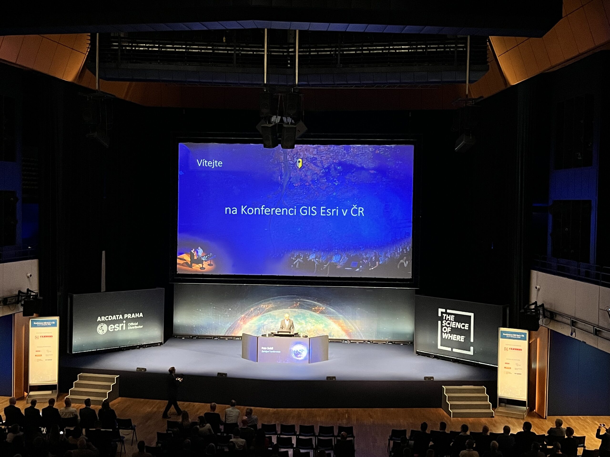
Na webových stránkách společnosti ARCDATA PRAHA naleznete první informace o hlavních řečnících letošní konference. Budou jimi: brig. gen. Ing. Václav Žid – zástupce ředitele Vojenského zpravodajství a ředitel jeho technické sekce, expert na kybernetickou bezpečnost a dálkový průzkum Země. Brigádní generál Václav Žid je zástupcem ředitele Vojenského zpravodajství a ředitelem jeho technické sekce. Většinu své kariéry spojil s […]
The post Kdo budou hlavní řečníci na letošní konferenci GIS Esri v Praze? appeared first on GISportal.cz.
Kdo budou hlavní řečníci na letošní konferenci GIS Esri v Praze?
13.9.2024 9:26 GISportal.czNa webových stránkách společnosti ARCDATA PRAHA naleznete první informace o hlavních řečnících letošní konference. Budou jimi: brig. gen. Ing. Václav Žid – zástupce ředitele Vojenského zpravodajství a ředitel jeho technické sekce, expert na kybernetickou bezpečnost a dálkový průzkum Země. Brigádní generál Václav Žid je zástupcem ředitele Vojenského zpravodajství a ředitelem jeho technické sekce. Většinu své kariéry spojil s […]
The post Kdo budou hlavní řečníci na letošní konferenci GIS Esri v Praze? appeared first on GISportal.cz.
20240913- VŘ KP Zlín
13.9.2024 8:30 ČÚZK - aktuality v resortu Oznámení o vyhlášení výběrového řízení na obsazení služebního místa ředitele/ředitelky Katastrálního pracoviště Zlín.20240913- VŘ KP Zlín
13.9.2024 8:30 ČÚZK - předpisy a opatření Český úřad zeměměřický a katastrálnízveřejnil novou aktualitu: Oznámení o vyhlášení výběrového řízení na obsazení služebního místa ředitele/ředitelky Katastrálního pracoviště Zlín.
20240913- VŘ KP Zlín
13.9.2024 8:30 ČÚZK - předpisy a opatření Český úřad zeměměřický a katastrální zveřejnil novou aktualitu: Oznámení o vyhlášení výběrového řízení na obsazení služebního místa ředitele/ředitelky Katastrálního pracoviště Zlín.20240913- VŘ KP Zlín
13.9.2024 8:30 ČÚZK - aktuality v resortu Oznámení o vyhlášení výběrového řízení na obsazení služebního místa ředitele/ředitelky Katastrálního pracoviště Zlín.Asociace podnikatelů v geomatice zve na konferenci Geomatika 2024
13.9.2024 8:30 GeoBusiness Asociace podnikatelů v geomatice zve všechny zájemce na konferenci GEOMATIKA 2024. Akce se uskuteční ve čtvrtek 17. října 2024 od 14:00 v hotelu Clarion Congress, Freyova 33, Praha – Vysočany. Akci moderuje Ing. Jaroslav Cibulka, výkonný ředitel asociace. Program konference Geomatika 2024 Úvodní slovo – Ing. Martin Hrdlička (předseda představenstva APG) Blok I: Česká komora […]Asociace podnikatelů v geomatice zve na konferenci Geomatika 2024
13.9.2024 8:30 GeoBusinessAsociace podnikatelů v geomatice zve všechny zájemce na konferenci GEOMATIKA 2024. Akce se uskuteční ve čtvrtek 17. října 2024 od 14:00 v hotelu Clarion Congress, Freyova 33, Praha – Vysočany. Akci moderuje Ing. Jaroslav Cibulka, výkonný ředitel asociace. Program konference Geomatika 2024 Úvodní slovo – Ing. Martin Hrdlička (předseda představenstva APG) Blok I: Česká komora […]
The post Asociace podnikatelů v geomatice zve na konferenci Geomatika 2024 appeared first on GeoBusiness.
odborný referent – zápisy v řízení V a Z, ISoSS ID 30003489
13.9.2024 8:23 ČÚZK /Urady/Katastralni-urady/Katastralni-urady/Katastralni-urad-pro-Olomoucky-kraj/Uredni-deska/Oznameni-a-jina-uredni-sdeleni/Volna-mista/DMS/odborny-referent-–-zapisy-v-rizeni-V-a-Z,-ISoS-(1)odborný referent – zápisy v řízení V a Z, ISoSS ID 30003489
13.9.2024 8:23 ČÚZK - předpisy a opatření Katastrální úřad pro Olomoucký kraj Katastrální pracoviště Olomoucvypisuje výběrové řízení na místo
odborný referent – zápisy v řízení V a Z, ISoSS ID 30003489
odborný referent – zápisy v řízení V a Z, ISoSS ID 30003489
13.9.2024 8:23 ČÚZK - volná místa Katastrální úřad pro Olomoucký kraj Katastrální pracoviště Olomouc vypisuje výběrové řízení na místo odborný referent – zápisy v řízení V a Z, ISoSS ID 30003489Dronedge 2025 – 10. ročník konference Aliance pro bezpilotní letecký průmysl
13.9.2024 8:19 UAVA Pomalu připravujeme 10. výroční ročník konference Aliance pro bezpilotní letecký průmysl – Dronedge 2025. O přípravách na tuto výroční akci budeme zde informovat, předpokládaný termín září 2025.odborný referent – zápisy v řízení V a Z, ISoSS ID 30003487
13.9.2024 8:08 ČÚZK /Urady/Katastralni-urady/Katastralni-urady/Katastralni-urad-pro-Olomoucky-kraj/Uredni-deska/Oznameni-a-jina-uredni-sdeleni/Volna-mista/DMS/odborny-referent-–-zapisy-v-rizeni-V-a-Z,-ISoSS-IDodborný referent – zápisy v řízení V a Z, ISoSS ID 30003487
13.9.2024 8:08 ČÚZK - volná místa Katastrální úřad pro Olomoucký kraj Katastrální pracoviště Olomouc vypisuje výběrové řízení na místo odborný referent – zápisy v řízení V a Z, ISoSS ID 30003487odborný referent – zápisy v řízení V a Z, ISoSS ID 30003487
13.9.2024 8:08 ČÚZK - předpisy a opatření Katastrální úřad pro Olomoucký kraj Katastrální pracoviště Olomoucvypisuje výběrové řízení na místo
odborný referent – zápisy v řízení V a Z, ISoSS ID 30003487
Nedostupnost WSDP na zkoušku ve dnech 17.9. - 20.9.2024
13.9.2024 6:38 Dálkový přístup k údajům KN ČR Vážení uživatelé webových služeb,oznamujeme, že z technických důvodů nebudou ve dnech 17.9.2024 až 20.9.2024 dostupné webové služby dálkového přístupu na zkoušku.
Za komplikace se omlouváme a děkujeme za pochopení.
Nedostupnost WSDP na zkoušku ve dnech 17.9. - 20.9.2024
13.9.2024 6:38 ČÚZK - předpisy a opatření Vážení uživatelé webových služeb,oznamujeme, že z technických důvodů nebudou ve dnech 17.9.2024 až 20.9.2024 dostupné webové služby dálkového přístupu na zkoušku.
Za komplikace se omlouváme a děkujeme za pochopení.
Nedostupnost WSDP na zkoušku ve dnech 17.9. - 20.9.2024
13.9.2024 6:38 Dálkový přístup k údajům KN ČR Vážení uživatelé webových služeb,oznamujeme, že z technických důvodů nebudou ve dnech 17.9.2024 až 20.9.2024 dostupné webové služby dálkového přístupu na zkoušku.
Za komplikace se omlouváme a děkujeme za pochopení.
Nedostupnost WSDP na zkoušku ve dnech 17.9. - 20.9.2024
13.9.2024 6:38 ČÚZK /Aplikace-DP-do-KN/Aplikace-DP-do-KN/Archiv-DP/423105APGEO - Valná hromada APG 2024
13.9.2024 2:00 Asociace podnikatelů v geomatice Srdečně Vás zveme na valnou hromadu APG, která se uskuteční ve čtvrtek 17. října 2024 v Praze.APGEO - Konference GEOMATIKA 2024
13.9.2024 2:00 Asociace podnikatelů v geomatice Odborná konference GEOMATIKA 2023 se koná ve čtvrtek 17. 10. 2024 od 14:00 v hotelu Clarion Congress v Praze.Seminář Katastr nemovitostí XXIX., 2024
12.9.2024 23:13 Spolek zeměměřičů Brno Dne 3. října 2024 se uskuteční seminář o katastru nemovitostí a zeměměřictví. Kde: Hotel Atom, Velkomeziříčská 640/45, Třebíč Program 8:00 – 9:00 Prezence účastníků9:00 – 14:00 Seminář a diskuse Přednášející Mgr. Michal Králík, Ph.D. (Nejvyšší soud České republiky)Neoprávněné stavby a užívání cizího prostoru v rozhodovací praxi Nejvyššího soudu České republiky... Read more »rada / odborný rada - analytik v oddělení hospodářské správy kanceláře úřadu ředitele Katastrálního
12.9.2024 14:58 ČÚZK /Urady/Katastralni-urady/Katastralni-urady/Katastralni-urad-pro-Kralovehradecky-kraj/Uredni-deska/Oznameni-a-jina-uredni-sdeleni/Volna-mista/DMS/rada-odborny-rada-analytik-v-oddeleni-hospodarske-rada / odborný rada - analytik v oddělení hospodářské správy kanceláře úřadu ředitele Katastrálního
12.9.2024 14:58 ČÚZK - předpisy a opatření Katastrální úřad pro Královéhradecký kraj kancelář ředitelevypisuje výběrové řízení na místo
rada / odborný rada - analytik v oddělení hospodářské správy kanceláře úřadu ředitele Katastrálního úřadu pro Královéhradecký kraj