


zprávy
zdroje zpráv:Geografické príspevky na eŠVK PriF UK 2023
7.5.2023 13:41 Geocommunity.skPríspevok Geografické príspevky na eŠVK PriF UK 2023 zobrazený najskôr GeoCommunity.sk.
Electricity
7.5.2023 5:32 Satlab GeosolutionsBy integrating GNSS, cloud computing, big data, and LiDAR technologies, SatLab helps to achieve high precision time synchronization and ensure grid stability for intelligent grid infrastructure systems, eliminating the possibilities of safety hazards and unstable power control in remote control, monitoring, data collection, and other field operations.
The post Electricity appeared first on Global Satellite Positioning Solutions | SatLab Geosolutions AB.
Electricity
7.5.2023 5:32 Satlab Geosolutions By integrating GNSS, cloud computing, big data, and LiDAR technologies, SatLab helps to achieve high precision time synchronization and ensure grid stability for intelligent grid infrastructure systems, eliminating the possibilities of safety hazards and unstable power control in remote control, monitoring, data collection, and other field operations.DAEX DESIGN Standard pro truhláře a nábytkáře s akčními bonusy
5.5.2023 15:20 ŠPINAR - softwareVážení zákazníci, připravili jsme pro Vás DAEX DESIGN Standard pro výrobce a návrháře nábytku a interiérů s rozšiřujícími bonusy do 21. 5. 2023
The post DAEX DESIGN Standard pro truhláře a nábytkáře s akčními bonusy appeared first on ŠPINAR – software.
DAEX DESIGN Standard pro truhláře a nábytkáře s akčními bonusy
5.5.2023 15:20 ŠPINAR - softwareVážení zákazníci, připravili jsme pro Vás DAEX DESIGN Plus pro výrobce a návrháře nábytku a interiérů s rozšiřujícími bonusy do 7. 5. 2023
The post DAEX DESIGN Standard pro truhláře a nábytkáře s akčními bonusy appeared first on ŠPINAR – software.
Nové příklady vizualizací se zdroji světel pro DAEX DESIGN
5.5.2023 13:41 ŠPINAR - softwarePřipravili jsme pro Vás Příklady vizualizací a zdroje světel v3 pro DAEX DESIGN Standard, Plus a Pro 23
The post Nové příklady vizualizací se zdroji světel pro DAEX DESIGN appeared first on ŠPINAR – software.
Nové příklady vizualizací se zdroji světel pro DAEX DESIGN
5.5.2023 13:41 ŠPINAR - software Připravili jsme pro Vás Příklady vizualizací a zdroje světel v3 pro DAEX DESIGN Standard, Plus a Pro 23Nové příklady vizualizací se zdroji světel pro DAEX DESIGN
5.5.2023 13:41 ŠPINAR - softwarePřipravili jsme pro Vás Příklady vizualizací a zdroje světel v3 pro DAEX DESIGN Standard, Plus a Pro 23
The post Nové příklady vizualizací se zdroji světel pro DAEX DESIGN appeared first on ŠPINAR – software.
ESKN Nevizuálne služby - Vypublikovanie novej verzie integračného manuálu
5.5.2023 13:00
ÚGKK SR
Úrad geodézie, kartografie a katastra SR v Centrálnom metainformačnom systéme verejnej správy SR aktualizoval integračný manuál nevizuálnych služieb katastra nehnuteľností v ktorom boli aktualizované nové možnosti konzumácie služieb pre zmluvných partnerov.
#PortálESKN #od:05.05.2023@13:00 #do:12.05.2023@23:59
Aliance je opět partnerem největšího světového průzkumu Drone Industry Barometer 2023
5.5.2023 10:55 UAVAAliance je opět partnerem největšího světového průzkumu Drone Industry Barometer 2023 od DRONEII.com – Drone Industry Insights, kde moc prosíme o jeho vyplnění, máme pro to speciální link (pro české uživatele pro měření dosahu) prosíme tedy o vyplnění zde: https://www.surveymonkey.de/r/droneii-barometer-2023-czuav Za účast v průzkumu můžete vyhrát Skydio dron nebo vstupenky na eventy v příštím roce […]
The post Aliance je opět partnerem největšího světového průzkumu Drone Industry Barometer 2023 appeared first on UAV Aliance pro bezpilotní letecký průmysl.
Earth from Space: Farming the desert
5.5.2023 10:00 ESA Observing the Earth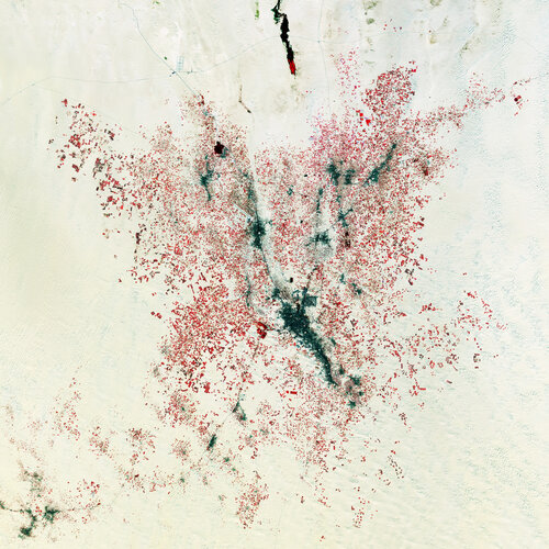 Image:
The Copernicus Sentinel-2 mission takes us over El Oued, in northeast Algeria, about 80 km west of the border with Tunisia.
Image:
The Copernicus Sentinel-2 mission takes us over El Oued, in northeast Algeria, about 80 km west of the border with Tunisia.
New Galileo Sensor Station up and running in South Pacific!
5.5.2023 9:21 European GNSS Agency
To make the best use of the Galileo services, users rely on much more than the satellites orbiting the Earth at an altitude of 23.000km. Dedicated facilities such as the Galileo Control Centres (GCCs), sensor and uplink stations are some of the most important components that make up the so-called ‘’Galileo Ground Segment’’ the role of which is to support the service provision of Europe’s own Global Navigation Satellite System. An important element of the Galileo Ground Segment is the Galileo Sensor Stations.
So, what are GSSs and why are they important to the constellation?
The Galileo Sensor Stations (GSS) is a network of antennas deployed at remote sites located around the world. They have small omnidirectional receiving antennas around just 50 cm high, and their role is to check the accuracy and signal quality of individual satellites in real-time and to pinpoint current satellite orbits.
These measurements are transmitted via secure satellite communications to the Galileo Control Centres in Fucino, Italy. Here they serve as the basis of a set of corrections – accounting for timing or orbital slips – to be uplinked to the satellites via a network of 3m-diameter uplink stations. This is then rebroadcasted within navigation messages to users, currently updated every 50 minutes.

A GSS located in Numea.
A thorough process
Establishing the GSS is not an easy procedure, and it requires meticulous attention as well as security accreditation by the Security Accreditation Board (SAB) of EUSPA.
The decision for the new location was made in June 2020 but due to the COVID pandemic, deployment began only in summer 2022. In October 2022, the second mission to Wallis and Futuna took place to complete the deployment of the GSS and connect it to the Ground Mission Segment network for data collection.
"EUSPA has been significantly upgrading the ground segments of both Galileo and EGNOS to ensure optimum performance Europe's satellite navigation systems," says EUSPA Executive Director, Rodrigo da Costa. "Wallis and Futuna are a strategic location which allows us to increase the coverage of Galileo in the southern hemisphere" he concluded.
Check out this map to learn more about Galileo sensors and stations across the globe.
Media note: This feature can be republished without charge provided the European Union Agency for the Space Programme (EUSPA) is acknowledged as the source at the top or the bottom of the story. You must request permission before you use any of the photographs on the site. If you republish, we would be grateful if you could link back to the EUSPA website (http://www.euspa.europa.eu).
vedení katastrální mapy
5.5.2023 7:53 ČÚZK - předpisy a opatření Katastrální úřad pro Olomoucký kraj Katastrální pracoviště Šumperkvypisuje výběrové řízení na místo
vedení katastrální mapy
vedení katastrální mapy
5.5.2023 7:53 ČÚZK - volná místa Katastrální úřad pro Olomoucký kraj Katastrální pracoviště Šumperk vypisuje výběrové řízení na místo vedení katastrální mapyvedení katastrální mapy
5.5.2023 7:53 ČÚZK /Urady/Katastralni-urady/Katastralni-urady/Katastralni-urad-pro-Olomoucky-kraj/Volna-mista/DMS/vedeni-katastralni-mapyZlatý erb Kraje Vysočina
4.5.2023 18:06 TopGis 18. dubna 2023 se uskutečnil jubilejní pětadvacátý ročník udílení cen Zlatý erb – Kraj Vysočina, které oceňuje nejlepší stránky měst a obcí. Vyhlašovalo se několik kategorií. V kategorii nejlepších webových stránek obce s rozšířenou působností zvítězila Jihlava, v kategorii nejlepších webových stránek obcí zvítězil Velký Beranov. Ceny veřejnosti pak putovaly do obcí Chotěboř a Jámy.Zlatý erb Kraje Vysočina
4.5.2023 16:06 TopGis18. dubna 2023 se uskutečnil jubilejní pětadvacátý ročník udílení cen Zlatý erb – Kraj Vysočina, které oceňuje nejlepší stránky měst a obcí. Vyhlašovalo se několik kategorií. V kategorii nejlepších webových stránek obce s rozšířenou působností zvítězila Jihlava, v kategorii nejlepších webových stránek obcí zvítězil Velký Beranov. Ceny veřejnosti pak putovaly do obcí Chotěboř a ...
Článek Zlatý erb Kraje Vysočina se nejdříve objevil na TopGis, s.r.o..
Zlatý erb Kraje Vysočina
4.5.2023 16:06 TopGis18. dubna 2023 se uskutečnil jubilejní pětadvacátý ročník udílení cen Zlatý erb – Kraj Vysočina, které oceňuje nejlepší stránky měst a obcí. Vyhlašovalo se několik kategorií. V kategorii nejlepších webových stránek obce s rozšířenou působností zvítězila Jihlava, v kategorii nejlepších webových stránek obcí zvítězil Velký Beranov. Ceny veřejnosti pak putovaly do obcí Chotěboř a ...
Článek Zlatý erb Kraje Vysočina se nejdříve objevil na TopGis, s.r.o..
Another year of climate extremes for Europe
4.5.2023 14:13 European GNSS Agency
According to the latest edition of the European State of the Climate Report (ESOTC), 2022 was yet another year of extremes. Not only did Europe see its hottest summer ever recorded, with temperatures reaching 1.4°C above average, much of Europe experienced prolonged and intense heatwaves.
Europe’s lakes and seas also saw increasing surface temperatures. While 73% of Europe’s lakes recorded warmer-than-average temperatures, average sea surface temperatures were the warmest on record.
Exacerbated by low precipitation, which continued through spring and summer for most regions in Europe, together with the exceptional heatwaves, Europe also experienced a widespread and prolonged drought in 2022. On the whole, the year was 10% drier than average. This lack of precipitation, including winter snow, combined with the exceptional summer heatwaves, contributed to a record loss of ice from glaciers in the Alps.
The European State of the Climate Report, which is published annually by the Copernicus Climate Change Service (C3S), provides key climate indicators plus insights and in-depth analysis on climate conditions during the previous calendar year. The Report’s findings are based largely on an analysis of the data and services provided by the Copernicus Earth Observation programme.
Meaningful action starts with critical data
By providing authoritative information about the rapidly changing climate in Europe, Copernicus helps climate researchers and authorities make informed decisions and take effective action. It is also providing entrepreneurs with data and information to face these changes and adapt their activities.
Copernicus is particularly useful for helping local authorities be more proactive to climate-related risks. For example, national and local authorities use C3S-produced heat stress predictions to implement heat-related action plans. These actions can include things as simple as limiting outside activities and drinking plenty of fluids to actively monitoring at-risk populations or designing cities in a way that could help mitigate heat-related risks. It is also providing entrepreneurs opportunities to prepare the future and develop applications.
ESOTC: an instrumental publication for EUSPA
"For us at EUSPA, the European State of the Climate (ESOTC) report is an instrumental publication for various reasons. Firstly, because it’s a confirmation that Union must accelerate its green transformation, and secondly because our agency has a role to play in the delivery of the EU Green Deal by providing space-based solutions," says EUSPA Executive Director, Rodrigo da Costa.
Since its creation in 2021, EUSPA has been entrusted with the promotion and market uptake of Copernicus services and products such as those of the Copernicus Climate Service (C3S).
According to the EUSPA EO and GNSS Market Report, the total revenues from the sale of both EO data and services in the Climate services sector in 2021 amounted to €318 m and will grow by almost 50% over the next decade to reach €451 m in 2031.
"It is therefore crucial for the EUSPA Market Development team to have up-to-date information and data about the state of the climate to support accordingly innovators and creators to propose the appropriate solutions" adds Fiammetta Diani, EUSPA Head of Market, Downstream and Innovation.
EUSPA has been actively utilizing various funding streams to promote innovation and entrepreneurship in climate-related products, services, and applications. This effort includes initiatives like Horizon Europe calls and innovation competitions such as the myEUspace competition, which is part of the CASSINI Initiative. As a result of these efforts, projects like 100KTREEs, SWIFTT, and MAGDA have been able to receive support.
- 100KTREEs is a Decision Toolbox designed to help cities improve air quality, biodiversity, human well-being, and reduce climate risks (such as urban heat islands and heatwaves) by planting more trees in urban areas.
- SWIFTT is an early warning system that uses EU space data and Artificial Intelligence to protect forest health and production by detecting forest threats such as forest bugs, heatwaves, fires, windthrow, and other climate-related events.
- Project MAGDA leverages GNSS (including Galileo) and drones to provide the agricultural sector with precise atmosphere monitoring. This project utilizes EU Space to predict and prepare for the future of weather, climate, and water.
A clear path forward
While the ESOTC report leaves no room for doubt that the climate is changing and that these changes are having extreme consequences here in Europe, it also gives us hope. If we fully leverage the wealth of data that Copernicus provides free of charge – and then act on it – there can be a clear path forward to a liveable future.
You can read the full European State of the Climate Report 2022 here.
C3S is implemented by the European Centre for Medium-Range Weather Forecasts (ECMWF) on behalf of the European Commission.
Media note: This feature can be republished without charge provided the European Union Agency for the Space Programme (EUSPA) is acknowledged as the source at the top or the bottom of the story. You must request permission before you use any of the photographs on the site. If you republish, we would be grateful if you could link back to the EUSPA website (http://www.euspa.europa.eu).
Meteosat Third Generation's first stunning image
4.5.2023 14:00 ESA Observing the Earth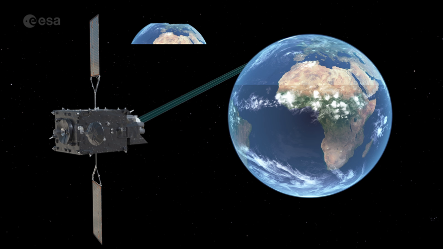 Video:
00:03:57
Video:
00:03:57
Europe’s latest weather satellite, the Meteosat Third Generation Imager, has just delivered its first image of Earth. What does this satellite do exactly? And what does this mean for weather forecasting? Learn more about the Meteosat Third Generation and how this new generation of satellites is set to revolutionise weather forecasting in Europe.
The Meteosat Third Generation image can be downloaded here.
Správce IKT
4.5.2023 13:04 ČÚZK /Urady/Zememericky-urad/Uredni-deska/Oznameni-a-jina-uredni-sdeleni/Volna-mista/DMS/Spravce-IKTSprávce IKT
4.5.2023 13:04 ČÚZK - volná místa Zeměměřický úřad vypisuje výběrové řízení na místo Správce IKTSprávce IKT
4.5.2023 13:04 ČÚZK - předpisy a opatření Zeměměřický úřadvypisuje výběrové řízení na místo
Správce IKT
Správce IKT
4.5.2023 13:04 Zeměměřický úřad Zeměměřický úřadvypisuje výběrové řízení na místo
Správce IKT
Asistent / Asistentka v personálním oddělení Katastrálního úřadu pro Zlínský kraj
4.5.2023 12:48 ČÚZK /Urady/Katastralni-urady/Katastralni-urady/Katastralni-urad-pro-Zlinsky-kraj/Volna-mista/DMS/Asistent-Asistentka-v-personalnim-oddeleni-KatastrAsistent / Asistentka v personálním oddělení Katastrálního úřadu pro Zlínský kraj
4.5.2023 12:48 ČÚZK - předpisy a opatření Katastrální úřad pro Zlínský kraj kancelář ředitelevypisuje výběrové řízení na místo
Asistent / Asistentka v personálním oddělení Katastrálního úřadu pro Zlínský kraj
Asistent / Asistentka v personálním oddělení Katastrálního úřadu pro Zlínský kraj
4.5.2023 12:48 ČÚZK - volná místa Katastrální úřad pro Zlínský kraj kancelář ředitele vypisuje výběrové řízení na místo Asistent / Asistentka v personálním oddělení Katastrálního úřadu pro Zlínský krajNew weather satellite reveals spectacular images of Earth
4.5.2023 10:00 ESA Observing the Earth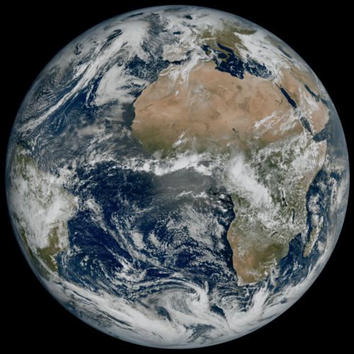
Europe’s latest weather satellite, the Meteosat Third Generation Imager, has just delivered its first view of Earth – revealing conditions over Europe, Africa and the Atlantic in remarkable detail.
Upravená dokumentace k JVF DTM verze 1.4.2.2
3.5.2023 23:02 ČÚZK - předpisy a opatření Do záložky JVF DTM byla přidána upravená dokumentace k nové verzi JVF DTM 1.4.2.2. Veškeré zapracované změny jsou v příslušných souborech dokumentace okomentovány a vyznačeny červeným písmem.Nordic Infrastructure Clients report
3.5.2023 20:00 buildingSMART.orgA report highlighting that there is a need for the Nordic public owners in infrastructure to agree on common guidelines and levels for information in digital models. This report will…
The post Nordic Infrastructure Clients report appeared first on buildingSMART International.
Odstávka prostředí INT1
3.5.2023 11:44 ČÚZK - předpisy a opatření Český úřad zeměměřický a katastrální upozorňuje na plánovanou odstávku integrační prostředí INT1 IS DMVS dne 9. května 2023, důvodem je nasazení nové verze 1.4.3 informačního systému. O ukončení odstávky vás budeme informovat. Omlouváme se za případné komplikace.Odstávka prostředí INT1
3.5.2023 11:44 ČÚZK - předpisy a opatření Český úřad zeměměřický a katastrální upozorňuje na plánovanou odstávku integrační prostředí INT1 IS DMVS dne 9. května 2023, důvodem je nasazení nové verze 1.4.3.1 informačního systému. O ukončení odstávky vás budeme informovat. Omlouváme se za případné komplikace.Prodej vozidla - Škoda Octavia
3.5.2023 10:51 ČÚZK - předpisy a opatřeníKatastrální úřad pro Plzeňský kraj nabízí nepotřebný majetek k odkupu. Jedná se o
Prodej vozidla - Škoda Octavia
Prodej vozidla - Škoda Octavia
3.5.2023 10:51 ČÚZK /Urady/Katastralni-urady/Katastralni-urady/Katastralni-urad-pro-Plzensky-kraj/Nabidky-majetku/Prodej-vozidla-Skoda-Octavia-(2)Prodej vozidla - Škoda Octavia
3.5.2023 10:50 ČÚZK - předpisy a opatřeníKatastrální úřad pro Plzeňský kraj nabízí nepotřebný majetek k odkupu. Jedná se o
Prodej vozidla - Škoda Octavia
Prodej vozidla - Škoda Octavia
3.5.2023 10:50 ČÚZK /Urady/Katastralni-urady/Katastralni-urady/Katastralni-urad-pro-Plzensky-kraj/Nabidky-majetku/Prodej-vozidla-Skoda-Octavia-(1)Prodej vozidla - Škoda Octavia
3.5.2023 10:48 ČÚZK - předpisy a opatřeníKatastrální úřad pro Plzeňský kraj nabízí nepotřebný majetek k odkupu. Jedná se o
Prodej vozidla - Škoda Octavia
Prodej vozidla - Škoda Octavia
3.5.2023 10:48 ČÚZK /Urady/Katastralni-urady/Katastralni-urady/Katastralni-urad-pro-Plzensky-kraj/Nabidky-majetku/Prodej-vozidla-Skoda-OctaviaVrchní referent/rada – obnova katastrálního operátu
3.5.2023 9:26 ČÚZK - volná místa Katastrální úřad pro Moravskoslezský kraj Katastrální pracoviště Ostrava vypisuje výběrové řízení na místo Vrchní referent/rada – obnova katastrálního operátuVrchní referent/rada – obnova katastrálního operátu
3.5.2023 9:26 ČÚZK - předpisy a opatření Katastrální úřad pro Moravskoslezský kraj Katastrální pracoviště Ostravavypisuje výběrové řízení na místo
Vrchní referent/rada – obnova katastrálního operátu
Odborný referent/vrchní referent – kontrola aktualizace
3.5.2023 9:23 ČÚZK /Urady/Katastralni-urady/Katastralni-urady/Katastralni-urad-pro-Moravskoslezsky-kraj/Uredni-deska/Oznameni-a-jina-uredni-sdeleni/Volna-mista/DMS/Odborny-referent-vrchni-referent-–-kontrola-aktualOdborný referent/vrchní referent – kontrola aktualizace
3.5.2023 9:23 ČÚZK - předpisy a opatření Katastrální úřad pro Moravskoslezský kraj Katastrální pracoviště Ostravavypisuje výběrové řízení na místo
Odborný referent/vrchní referent – kontrola aktualizace
Odborný referent/vrchní referent – kontrola aktualizace
3.5.2023 9:23 ČÚZK - volná místa Katastrální úřad pro Moravskoslezský kraj Katastrální pracoviště Ostrava vypisuje výběrové řízení na místo Odborný referent/vrchní referent – kontrola aktualizaceVrchní referent/rada – obnova katastrálního operátu
3.5.2023 9:18 ČÚZK - předpisy a opatření Katastrální úřad pro Moravskoslezský kraj Katastrální pracoviště Karvinávypisuje výběrové řízení na místo
Vrchní referent/rada – obnova katastrálního operátu
Vrchní referent/rada – obnova katastrálního operátu
3.5.2023 9:18 ČÚZK - volná místa Katastrální úřad pro Moravskoslezský kraj Katastrální pracoviště Karviná vypisuje výběrové řízení na místo Vrchní referent/rada – obnova katastrálního operátuOdborný referent – oddělení aktualizace KN
3.5.2023 8:38 ČÚZK - předpisy a opatření Katastrální úřad pro Karlovarský kraj Katastrální pracoviště Chebvypisuje výběrové řízení na místo
Odborný referent – oddělení aktualizace KN
Odborný referent – oddělení aktualizace KN
3.5.2023 8:38 ČÚZK - volná místa Katastrální úřad pro Karlovarský kraj Katastrální pracoviště Cheb vypisuje výběrové řízení na místo Odborný referent – oddělení aktualizace KNOdborný referent – oddělení aktualizace KN
3.5.2023 8:38 ČÚZK /Urady/Katastralni-urady/Katastralni-urady/Katastralni-urad-pro-Karlovarsky-kraj/Uredni-deska/Oznameni-a-jina-uredni-sdeleni/Volna-mista/DMS/Odborny-referent-–-oddeleni-aktualizace-KNPlzeňská estakáda SO 1202 otevřena
3.5.2023 8:18 Hrdlička Užijte si s námi nádherné záběry z výšky, které byly pořízeny dronem.Stonex R60 - nová totální stanice s OS Android
2.5.2023 15:55 GEUSware5,5 palcový barevný dotykový displej
SW Cube-a v prostředí Android v češtině
dvě provedení dle úhlové přesnosti (2" a 1")
dosah na hranol až 5000m
dosah bez hranolu až 1000m
snadný a rychlý přenos dat do RTK kontrolérů
vytyčovací světla
Li-Ion baterie 5200mAh/7,2V
Zaváděcí cena: 119.900,- Kč bez DPH
Bližší informace viz e-shop
20230502 - VŘ ředitel/ředitelka KÚ pro Královéhradecký kraj
2.5.2023 13:58 ČÚZK /Aktuality-resort/2023/20230502-VR-reditel-reditelka-KU-pro-Kralovehradec20230502 - VŘ ředitel/ředitelka KÚ pro Královéhradecký kraj
2.5.2023 13:58 ČÚZK - aktuality v resortu Oznámení o vyhlášení výběrového řízení na obsazení služebního místa vedoucí služebního úřadu - ředitel/ředitelka Katastrálního úřadu pro Královéhradecký kraj.20230502 - VŘ ředitel/ředitelka KÚ pro Královéhradecký kraj
2.5.2023 13:58 ČÚZK - předpisy a opatření Český úřad zeměměřický a katastrální zveřejnil novou aktualitu: Oznámení o vyhlášení výběrového řízení na obsazení služebního místa vedoucí služebního úřadu - ředitel/ředitelka Katastrálního úřadu pro Královéhradecký kraj.20230502 - VŘ ředitel/ředitelka KÚ pro Zlínský kraj
2.5.2023 13:49 ČÚZK - předpisy a opatření Český úřad zeměměřický a katastrální zveřejnil novou aktualitu: Oznámení o vyhlášení výběrového řízení na obsazení služebního místa vedoucí služebního úřadu - ředitel/ředitelka Katastrálního úřadu pro Zlínský kraj.20230502 - VŘ ředitel/ředitelka KÚ pro Zlínský kraj
2.5.2023 13:49 ČÚZK - aktuality v resortu Oznámení o vyhlášení výběrového řízení na obsazení služebního místa vedoucí služebního úřadu - ředitel/ředitelka Katastrálního úřadu pro Zlínský kraj.20230502 - VŘ ředitel/ředitelka KÚ pro Zlínský kraj
2.5.2023 13:49 ČÚZK /Aktuality-resort/2023/20230502-VR-reditel-reditelka-KU-pro-Zlinsky-kraj20230502 - VŘ ředitel/ředitelka KÚ pro Vysočinu
2.5.2023 13:40 ČÚZK - aktuality v resortu Oznámení o vyhlášení výběrového řízení na obsazení služebního místa vedoucí služebního úřadu - ředitel/ředitelka Katastrálního úřadu pro Vysočinu.20230502 - VŘ ředitel/ředitelka KÚ pro Vysočinu
2.5.2023 13:40 ČÚZK /Aktuality-resort/2023/20230502-VR-reditel-reditelka-KU-pro-Vysocinu20230502 - VŘ ředitel/ředitelka KÚ pro Vysočinu
2.5.2023 13:40 ČÚZK - předpisy a opatření Český úřad zeměměřický a katastrální zveřejnil novou aktualitu: Oznámení o vyhlášení výběrového řízení na obsazení služebního místa vedoucí služebního úřadu - ředitel/ředitelka Katastrálního úřadu pro Vysočinu.20230502 - VŘ ředitel/ředitelka KÚ pro Liberecký kraj
2.5.2023 13:31 ČÚZK - aktuality v resortu Oznámení o vyhlášení výběrového řízení na obsazení služebního místa vedoucí služebního úřadu - ředitel/ředitelka Katastrálního úřadu pro Liberecký kraj.20230502 - VŘ ředitel/ředitelka KÚ pro Liberecký kraj
2.5.2023 13:31 ČÚZK /Aktuality-resort/2023/20230502-VR-reditel-reditelka-KU-pro-Liberecky-kra20230502 - VŘ ředitel/ředitelka KÚ pro Liberecký kraj
2.5.2023 13:31 ČÚZK - předpisy a opatření Český úřad zeměměřický a katastrální zveřejnil novou aktualitu: Oznámení o vyhlášení výběrového řízení na obsazení služebního místa vedoucí služebního úřadu - ředitel/ředitelka Katastrálního úřadu pro Liberecký kraj.20230502 - VŘ ředitel/ředitelka KÚ pro Moravskoslezský kraj
2.5.2023 13:19 ČÚZK - aktuality v resortu Oznámení o vyhlášení výběrového řízení na obsazení služebního místa vedoucí služebního úřadu - ředitel/ředitelka Katastrálního úřadu pro Moravskoslezský kraj.20230502 - VŘ ředitel/ředitelka KÚ pro Moravskoslezský kraj
2.5.2023 13:19 ČÚZK /Aktuality-resort/2023/20230502-VR-reditel-reditelka-KU-pro-Moravskoslezs20230502 - VŘ ředitel/ředitelka KÚ pro Moravskoslezský kraj
2.5.2023 13:19 ČÚZK - předpisy a opatření Český úřad zeměměřický a katastrální zveřejnil novou aktualitu: Oznámení o vyhlášení výběrového řízení na obsazení služebního místa vedoucí služebního úřadu - ředitel/ředitelka Katastrálního úřadu pro Moravskoslezský kraj.Vedoucí služebního úřadu - ředitel/ředitelka Katastrálního úřadu pro Královéhradecký kraj
2.5.2023 13:06 ČÚZK - předpisy a opatření Český úřad zeměměřický a katastrálnívypisuje výběrové řízení na místo
Vedoucí služebního úřadu - ředitel/ředitelka Katastrálního úřadu pro Královéhradecký kraj
Vedoucí služebního úřadu - ředitel/ředitelka Katastrálního úřadu pro Královéhradecký kraj
2.5.2023 13:06 ČÚZK - volná místa Český úřad zeměměřický a katastrální vypisuje výběrové řízení na místo Vedoucí služebního úřadu - ředitel/ředitelka Katastrálního úřadu pro Královéhradecký krajVedoucí služebního úřadu - ředitel/ředitelka Katastrálního úřadu pro Královéhradecký kraj
2.5.2023 13:06 ČÚZK /Urady/Cesky-urad-zememericky-a-katastralni/Uredni-deska/Oznameni-a-jina-uredni-sdeleni/Volna-mista/DMS/Vedouci-sluzebniho-uradu-reditel-reditelka-Kat-(7)Vedoucí služebního úřadu - ředitel/ředitelka Katastrálního úřadu pro Zlínský kraj
2.5.2023 13:00 ČÚZK - volná místa Český úřad zeměměřický a katastrální vypisuje výběrové řízení na místo Vedoucí služebního úřadu - ředitel/ředitelka Katastrálního úřadu pro Zlínský krajVedoucí služebního úřadu - ředitel/ředitelka Katastrálního úřadu pro Zlínský kraj
2.5.2023 13:00 ČÚZK /Urady/Cesky-urad-zememericky-a-katastralni/Uredni-deska/Oznameni-a-jina-uredni-sdeleni/Volna-mista/DMS/Vedouci-sluzebniho-uradu-reditel-reditelka-Kat-(6)Vedoucí služebního úřadu - ředitel/ředitelka Katastrálního úřadu pro Zlínský kraj
2.5.2023 13:00 ČÚZK - předpisy a opatření Český úřad zeměměřický a katastrálnívypisuje výběrové řízení na místo
Vedoucí služebního úřadu - ředitel/ředitelka Katastrálního úřadu pro Zlínský kraj
Vedoucí služebního úřadu - ředitel/ředitelka Katastrálního úřadu pro Vysočinu
2.5.2023 12:52 ČÚZK - volná místa Český úřad zeměměřický a katastrální vypisuje výběrové řízení na místo Vedoucí služebního úřadu - ředitel/ředitelka Katastrálního úřadu pro VysočinuVedoucí služebního úřadu - ředitel/ředitelka Katastrálního úřadu pro Vysočinu
2.5.2023 12:52 ČÚZK /Urady/Cesky-urad-zememericky-a-katastralni/Uredni-deska/Oznameni-a-jina-uredni-sdeleni/Volna-mista/DMS/Vedouci-sluzebniho-uradu-reditel-reditelka-Kat-(5)Vedoucí služebního úřadu - ředitel/ředitelka Katastrálního úřadu pro Vysočinu
2.5.2023 12:52 ČÚZK - předpisy a opatření Český úřad zeměměřický a katastrálnívypisuje výběrové řízení na místo
Vedoucí služebního úřadu - ředitel/ředitelka Katastrálního úřadu pro Vysočinu
Vedoucí služebního úřadu - ředitel/ředitelka Katastrálního úřadu pro Liberecký kraj
2.5.2023 12:43 ČÚZK - předpisy a opatření Český úřad zeměměřický a katastrálnívypisuje výběrové řízení na místo
Vedoucí služebního úřadu - ředitel/ředitelka Katastrálního úřadu pro Liberecký kraj
Vedoucí služebního úřadu - ředitel/ředitelka Katastrálního úřadu pro Liberecký kraj
2.5.2023 12:43 ČÚZK - volná místa Český úřad zeměměřický a katastrální vypisuje výběrové řízení na místo Vedoucí služebního úřadu - ředitel/ředitelka Katastrálního úřadu pro Liberecký krajVedoucí služebního úřadu - ředitel/ředitelka Katastrálního úřadu pro Liberecký kraj
2.5.2023 12:43 ČÚZK /Urady/Cesky-urad-zememericky-a-katastralni/Uredni-deska/Oznameni-a-jina-uredni-sdeleni/Volna-mista/DMS/Vedouci-sluzebniho-uradu-reditel-reditelka-Kat-(4)Vedoucí služebního úřadu - ředitel/ředitelka Katastrálního úřadu pro Moravskoslezský kraj
2.5.2023 12:36 ČÚZK - volná místa Český úřad zeměměřický a katastrální vypisuje výběrové řízení na místo Vedoucí služebního úřadu - ředitel/ředitelka Katastrálního úřadu pro Moravskoslezský krajVedoucí služebního úřadu - ředitel/ředitelka Katastrálního úřadu pro Moravskoslezský kraj
2.5.2023 12:36 ČÚZK /Urady/Cesky-urad-zememericky-a-katastralni/Uredni-deska/Oznameni-a-jina-uredni-sdeleni/Volna-mista/DMS/Vedouci-sluzebniho-uradu-reditel-reditelka-Kat-(3)Vedoucí služebního úřadu - ředitel/ředitelka Katastrálního úřadu pro Moravskoslezský kraj
2.5.2023 12:36 ČÚZK - předpisy a opatření Český úřad zeměměřický a katastrálnívypisuje výběrové řízení na místo
Vedoucí služebního úřadu - ředitel/ředitelka Katastrálního úřadu pro Moravskoslezský kraj
rada/odborný rada – ředitel/ka odboru dokumentace
2.5.2023 11:48 ČÚZK - volná místa Katastrální úřad pro hlavní město Prahu vypisuje výběrové řízení na místo rada/odborný rada – ředitel/ka odboru dokumentacerada/odborný rada – ředitel/ka odboru dokumentace
2.5.2023 11:48 ČÚZK - předpisy a opatření Katastrální úřad pro hlavní město Prahuvypisuje výběrové řízení na místo
rada/odborný rada – ředitel/ka odboru dokumentace
rada/odborný rada – ředitel/ka odboru dokumentace
2.5.2023 11:48 ČÚZK /Urady/Katastralni-urady/Katastralni-urady/Katastralni-urad-pro-hlavni-mesto-Prahu/Uredni-deska/Oznameni-a-jina-uredni-sdeleni/Volna-mista/DMS/rada-odborny-rada-–-reditel-ka-odboru-dokumentaceZveřejnění obsahu informací poskytnutých na žádost dle zákona č. 106/1999 Sb. za rok 20
2.5.2023 11:39 ČÚZK - předpisy a opatření Katastrální úřad pro Karlovarský krajzveřejňuje obsah informace poskytnutých na žádost dle zákona č. 106/1999 Sb. za rok
2023
Zveřejnění obsahu informací poskytnutých na žádost dle zákona č. 106/1999 Sb. za rok 2023
2.5.2023 11:39 ČÚZK - předpisy a opatření Katastrální úřad pro Karlovarský krajzveřejňuje obsah informace poskytnutých na žádost dle zákona č. 106/1999 Sb. za rok
2023
Zveřejnění obsahu informací poskytnutých na žádost dle zákona č. 106/1999 Sb. za rok 20
2.5.2023 11:39 ČÚZK /Urady/Katastralni-urady/Katastralni-urady/Katastralni-urad-pro-Karlovarsky-kraj/Casto-hledane-informace/Poskytovani-informaci-106-1999-Sb/Zverejneni-obsahu-informaci-poskytnutych-na-za-(1)/Zverejneni-obsahu-informaci-poskytnutych-na-za-(5)Zveřejnění obsahu informací poskytnutých na žádost dle zákona č. 106/1999 Sb. za rok 2023
2.5.2023 11:39 ČÚZK /Urady/Katastralni-urady/Katastralni-urady/Katastralni-urad-pro-Karlovarsky-kraj/Casto-hledane-informace/Poskytovani-informaci-106-1999-Sb/Zverejneni-obsahu-informaci-poskytnutych-na-za-(1)/Zverejneni-obsahu-informaci-poskytnutych-na-za-(5)Balíček 3D Ready Pack – využijte licence na max
2.5.2023 10:43 Arkance SystemsK novým licencím Autodesk Inventoru a Product Design & Manufacturing Collection nyní nabízíme balíček aplikací a služeb zdarma.
Zpráva Balíček 3D Ready Pack – využijte licence na max pochází z arkance-systems.cz.
Balíček 3D Ready Pack pro Autodesk Inventor
2.5.2023 10:43 Arkance SystemsVyužijte nové licence Inventoru na max. Jen u Arkance Systems s balíčkem plným benefitů - aplikací i služeb.
Zpráva Balíček 3D Ready Pack pro Autodesk Inventor pochází z arkance-systems.cz.
ISKN Import a VFR Import pro ArcGIS Pro 3.1
2.5.2023 10:30 ARCDATAVydali jsme nové verze doplňků ISKN Import a VFR Import, které jsou kompatibilní s ArcGIS Pro 3.1. Na příslušných stránkách si můžete stáhnout bezplatné verze doplňků, umožňující základní import dat RÚIAN (VFR) a ISKN (VFK).
Jaké jsou novinky v těchto verzích?
VFR Import 3.1.5
- Zaslání e-mailu v případě, že nedojde k načtení licence ArcGIS při spouštění konzolové aplikace. (K tomu může dojít například když vás ArcGIS Pro odhlásí.)
- Nový parametr EnableSsl pro možnost použití Secure Sockets Layer (SSL) při posílání e-mailů.
- Doplnění dokumentace o kapitolu Datový model.
Opravy
- Byl opraven datový typ pole Vusc (ze short int na long int) u třídy prvků Okres. Pokud datový model již vytvořený máte, je třeba změnit datový typ pole manuálně.
- Opraveno odstraňování atributových indexů při importu v postgresql.
ISKN Import 3.1.6
- Vytváření atributových indexů na místech, kde je automaticky vytváří relační třídy, při spouštění nástroje s licencí ArcGIS Pro Basic.
- Sestavení geometrie po aktualizaci pomocí změnových souborů.
- Parametr umožňující sestavení linií (jako je lomená čára), které nemají v datech definovaný atribut typ spojení.
- Relační třídy mezi tabulkami JED – RIZENI a JPV – RIZENI.
- Vylepšení importu změnových a stavových dat v určitých specifických případech.
- Atributové indexy se při importu změnových souborů neodstraňují.
- Úprava a doplnění dokumentace.
Opravy
- Chyba při hledání podle vlastníka v ArcGIS Pro 3.X v ISKN View.
- Doplnění dokumentace ISKN View do archivu ZIP s instalačními soubory.
- Vytváření a odstraňování atributových indexů v postgresql.
- Proces deanonymizace v postgresql.
- Zápis metadat v postgresql.
- Bug při vytváření datového modelu ve FGDB (ArcGIS Pro 3.1).

výběrové řízení na KP Jihlava
2.5.2023 9:38 ČÚZK /Urady/Katastralni-urady/Katastralni-urady/Katastralni-urad-pro-Vysocinu/O-uradu/Aktuality/vyberove-rizeni-na-KP-Jihlava-(3)výběrové řízení na KP Jihlava
2.5.2023 9:38 ČÚZK - předpisy a opatření Katastrální úřad pro Vysočinu - Katastrální pracoviště Jihlava zveřejnil novou aktualitu: Oznámení o vyhlášení výběrového řízení na služební místo odborný referent v oddělení aktualizace KN I Katastrálního pracoviště Jihlava.odborný referent - KP JI aktualizace KN I
2.5.2023 9:12 ČÚZK - předpisy a opatření Katastrální úřad pro Vysočinu Katastrální pracoviště Jihlavavypisuje výběrové řízení na místo
odborný referent - KP JI aktualizace KN I
odborný referent - KP JI aktualizace KN I
2.5.2023 9:12 ČÚZK /Urady/Katastralni-urady/Katastralni-urady/Katastralni-urad-pro-Vysocinu/Uredni-deska/Oznameni-a-jina-uredni-sdeleni/Volna-mista/DMS/odborny-referent-KP-JI-aktualizace-KN-Iodborný referent - KP JI aktualizace KN I
2.5.2023 9:12 ČÚZK - volná místa Katastrální úřad pro Vysočinu Katastrální pracoviště Jihlava vypisuje výběrové řízení na místo odborný referent - KP JI aktualizace KN IDAEX DESIGN Plus – vše pro truhláře a nábytkáře v jednom s akčními bonusy
1.5.2023 20:02 ŠPINAR - software Vážení zákazníci, připravili jsme pro Vás DAEX DESIGN Plus pro výrobce a návrháře nábytku a interiérů s rozšiřujícími bonusy do 7. 5. 2023DAEX DESIGN Plus – vše pro truhláře a nábytkáře v jednom s akčními bonusy
1.5.2023 20:02 ŠPINAR - softwareVážení zákazníci, připravili jsme pro Vás DAEX DESIGN Plus pro výrobce a návrháře nábytku a interiérů s rozšiřujícími bonusy do 7. 5. 2023
The post DAEX DESIGN Plus – vše pro truhláře a nábytkáře v jednom s akčními bonusy appeared first on ŠPINAR – software.
DAEX DESIGN Plus – vše pro truhláře a nábytkáře v jednom s akčními bonusy
1.5.2023 20:02 ŠPINAR - softwareVážení zákazníci, připravili jsme pro Vás DAEX DESIGN Plus pro výrobce a návrháře nábytku a interiérů s rozšiřujícími bonusy do 7. 5. 2023
The post DAEX DESIGN Plus – vše pro truhláře a nábytkáře v jednom s akčními bonusy appeared first on ŠPINAR – software.
buildingSMART International Publishes the Strategic Roadmap
1.5.2023 15:31 czBIM27. 4. 2023 od 10:00 – 12:00, online In one of my first blogs in this role, I set out as a priority the creation...
Článek buildingSMART International Publishes the Strategic Roadmap se nejdříve objevil na czBIM.
buildingSMART International Publishes the Strategic Roadmap
1.5.2023 15:31 czBIM27. 4. 2023 od 10:00 – 12:00, online In one of my first blogs in this role, I set out as a priority the creation...
Článek buildingSMART International Publishes the Strategic Roadmap se nejdříve objevil na czBIM.
buildingSMART International Publishes the Strategic Roadmap
1.5.2023 15:31 czBIM27. 4. 2023 od 10:00 – 12:00, online In one of my first blogs in this role, I set out as a priority the creation...
Článek buildingSMART International Publishes the Strategic Roadmap se nejdříve objevil na czBIM.
Setkání GEPRO & ATLAS 2023
28.4.2023 12:23 GEPROLetošní září se blíží a s ním i nejvýznamnější událost našeho oboru – konference Setkání uživatelů GEPRO & ATLAS 2023. S radostí vám přinášíme pozvání na tuto tradiční akci, která se již standardně koná v hotelu Olšanka v Praze. Termín jsme zvolili podobně jako v loňském roce, již v září, tentokrát ve středu a čtvrtek …
Setkání GEPRO & ATLAS 2023 Pokračovat ve čtení »
Článek Setkání GEPRO & ATLAS 2023 se nejdříve objevil na GEPRO.
Setkání GEPRO & ATLAS 2023
28.4.2023 12:23 GEPROLetošní září se blíží a s ním i nejvýznamnější událost našeho oboru – konference Setkání uživatelů GEPRO & ATLAS 2023. S radostí vám přinášíme pozvání na tuto tradiční akci, která se již standardně koná v hotelu Olšanka v Praze. Termín jsme zvolili podobně jako v loňském roce, již v září, tentokrát ve středu a čtvrtek […]
Článek Setkání GEPRO & ATLAS 2023 se nejdříve objevil na GEPRO.
Setkání GEPRO & ATLAS 2023
28.4.2023 12:23 GEPROLetošní září se blíží a s ním i nejvýznamnější událost našeho oboru – konference Setkání uživatelů GEPRO & ATLAS 2023. S radostí vám přinášíme pozvání na tuto tradiční akci, která se již standardně koná v hotelu Olšanka v Praze. Termín jsme zvolili podobně jako v loňském roce, již v září, tentokrát ve středu a čtvrtek …
Setkání GEPRO & ATLAS 2023 Pokračovat ve čtení »
Článek Setkání GEPRO & ATLAS 2023 se nejdříve objevil na GEPRO.
Setkání GEPRO&ATLAS 2023
28.4.2023 12:23 GEPROLetošní září se blíží a s ním i nejvýznamnější událost našeho oboru – konference Setkání uživatelů GEPRO&ATLAS 2023. S radostí vám přinášíme pozvání na tuto tradiční akci, která se již standardně koná v hotelu Olšanka v Praze. Termín jsme zvolili podobně jako v loňském roce, již v září, tentokrát ve středu a čtvrtek 20. a …
Setkání GEPRO&ATLAS 2023 Pokračovat ve čtení »
Článek Setkání GEPRO&ATLAS 2023 se nejdříve objevil na GEPRO.
Repowering the EU from space
28.4.2023 10:57 European GNSS Agency
The EU’s energy dependence is becoming more complicated over the last months, so the EU has no choice but to look for new means of securing its energy supply.
But energy independence shouldn’t come at the cost of the climate. Which is why any decision relating to energy security must be aligned with meeting the EU’s goal of becoming climate neutral by 2050.
How do you strike this delicate balance between energy sovereignty and climate neutrality?
Renewable energy is one answer.
Today, approximately 22% of the EU’s energy comes from renewable sources. The REPowerEU initiative seeks to not only more than double this, but to do so in just a few years’ time.
Unfortunately, no ‘magic switch’ can flip to go from our current fossil fuel-based energy system to one based on renewables. But what we do have is EU Space.
From choosing the best location for wind turbines to understanding how dust storms might impact solar energy production, the EU Space Programme will be a key enabler of Europe’s energy transition.
Synchronising smart grids
Speaking of supplying the grid, the smart grids that will carry the renewable energy from source to switch will be based on the solid and robust synchronisation provided by GNSS. Specifically, these grids rely on GNSS clocks as a time reference, with atomic clocks serving as a backup in case of an outage.
To reduce the risk of outages, it is critical that the GNSS signals used for smart grid timing be resilient against interference. Here, not only does Galileo offer grid operators increased accuracy and robustness, the forthcoming Open Service Navigation Message Authentication (OSNMA) will add an extra layer of protection.
Add to this GNSS receivers’ comparably low cost and the fact that they can be easily implemented into a grid to enable real-time automatic control, and it’s easy to see why Galileo is becoming the go-to-solution for smart grid operators.

The accuracy and robustness of Galileo and the added layer of protection that will be offered by the OSNMA, means that Galileo will be the go-to solution for smart grid operators.
Using GNSS to maintain renewable infrastructure
GNSS will also play a role in maintaining renewable energy infrastructure and smart grid systems. That’s because the precise positioning services offered by Galileo and EGNOS, together with the latest developments in computer vision-aided navigation, enable the use of unmanned aerial vehicles (UAVs), or drones, to efficiently, effectively and safely inspect renewable energy infrastructure – which is often located in difficult-to-reach and remote locations.
Drones are already used to remotely detect solar panel hotspots, which can reduce power generation, and inspect wind turbine structures. With the recently launched Galileo High Accuracy Service (HAS), this capability will become even more efficient and widespread.
Using images provided by Sentinel satellites, these GNSS-enabled drones can also be used to inspect and predict landslides. Operators can use this information to monitor critical infrastructure. They may even be able to use it to conduct preventative maintenance, essentially fixing a problem (e.g., shoring up a potential landslide area) before it has a chance to cause damage.
Selecting the right site for renewable energy infrastructure
Power plant owners want to know where the best place to invest their money is. Thus, choosing the right location for renewable energy infrastructure is a key prerequisite to efficient energy production, and EU Space data makes finding the optimal site easier.
For example, using information gathered from Copernicus’ satellites and atmospheric models, the Copernicus Atmosphere Monitoring Service (CAMS) produces global irradiation models that the renewable energy sector can use to make informed decisions on where to best place solar panels.
Copernicus data can also be used to optimise the location of wind turbines. According to an article published by Observer, the Copernicus news service, by providing consistent, quality-controlled information about Europe’s past, present and potential future climate, Copernicus, and in particular the Copernicus Climate Change Service (C3S), has emerged as the tool of choice for selecting the right site for wind turbines.
Efficient operations and energy production
Once a site is selected and built, the next step is to get it up and running. But this is easier said than done, as plant and grid operators face several challenges unique to the renewable energy sector. Amongst these are constantly changing meteorological and atmospheric conditions, which can cause fluctuations in energy production.
To illustrate, consider the offshore windfarms that dot the coasts of countries like Belgium, Germany, Spain and Portugal. In order to optimise their operations, these energy companies rely on high-quality information about wind variability – information that is made freely available via C3S. Likewise, solar plant operators depend on CAMS aerosol forecasts to better anticipate dust storms, which allow them to take steps to prevent UV-blocking dust from accumulating on their photovoltaic panels.
Energy producers also rely on Copernicus data to accurately estimate the amount of energy they will be able to generate. For example, grid and plant operators can leverage data on the availability of solar, wind and other resources to more accurately determine which supply is likely to be more abundant. Independent producers use this information to commit how much energy they can supply to the grid, while Transmission System Operators use it to balance supply and demand.
Energy sovereignty and climate neutrality can go together
With the support of the EU Space Programme, which was conceived as a means of advancing European autonomy in space, we can build the autonomous renewable energy system that will power an energy independent and climate neutral future for Europe.
“Today’s energy crisis has a major impact on EU citizens and businesses” concludes EUSPA Executive Director Rodrigo da Costa. “However, at EUSPA we want to leverage the free data and services provided by EU Space to directly benefit EU citizens, by supporting renewable energies and improving management of grids.”
Media note: This feature can be republished without charge provided the European Union Agency for the Space Programme (EUSPA) is acknowledged as the source at the top or the bottom of the story. You must request permission before you use any of the photographs on the site. If you republish, we would be grateful if you could link back to the EUSPA website (http://www.euspa.europa.eu).
Odstávka Portálu ESKN
28.4.2023 10:45
ÚGKK SR
Dňa 28.4.2023 (piatok) od 13:00 hod. do 15:00 hod. môže dochádzať k výpadkom elektronických služieb katastra nehnuteľností, nakoľko bude realizovaná aktualizácia infraštruktúry systému elektronických služieb katastra nehnuteľností.
#PortálESKN #od:28.04.2023@13:00 #do:28.04.2023@15:00
referent/vrchní referent – informační a kontrolní pracovník
28.4.2023 10:31 ČÚZK - předpisy a opatření Katastrální úřad pro hlavní město Prahuvypisuje výběrové řízení na místo
referent/vrchní referent – informační a kontrolní pracovník
referent/vrchní referent – informační a kontrolní pracovník
28.4.2023 10:31 ČÚZK /Urady/Katastralni-urady/Katastralni-urady/Katastralni-urad-pro-hlavni-mesto-Prahu/Uredni-deska/Oznameni-a-jina-uredni-sdeleni/Volna-mista/DMS/referent-vrchni-referent-–-informacni-a-kontrolni-referent/vrchní referent – informační a kontrolní pracovník
28.4.2023 10:31 ČÚZK - volná místa Katastrální úřad pro hlavní město Prahu vypisuje výběrové řízení na místo referent/vrchní referent – informační a kontrolní pracovníkProdej 120 kusů betonových patek
28.4.2023 10:27 ČÚZK - předpisy a opatřeníKatastrální úřad pro Jihomoravský kraj nabízí nepotřebný majetek k odkupu. Jedná se o
Prodej 120 kusů betonových patek
Prodej 120 kusů betonových patek
28.4.2023 10:27 ČÚZK /Urady/Katastralni-urady/Katastralni-urady/Katastralni-urad-pro-Jihomoravsky-kraj/Nabidky-majetku/Prodej-120-kusu-betonovych-patek-(1)Earth from Space: Blooming California
28.4.2023 10:00 ESA Observing the Earth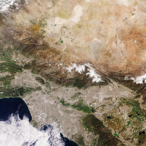 Image:
Captured by the Copernicus Sentinel-2 mission on 8 April 2023, this image shows Los Angeles and part of the hinterland in Southern California.
Image:
Captured by the Copernicus Sentinel-2 mission on 8 April 2023, this image shows Los Angeles and part of the hinterland in Southern California.
20230428_Odborný rada oddělení právních vztahů k nemovitostem
28.4.2023 9:23 ČÚZK /Urady/Katastralni-urady/Katastralni-urady/Katastralni-urad-pro-Stredocesky-kraj/Katastralni-pracoviste/KP-Rakovnik/O-uradu/Aktuality/20230111_Odborny-rada-oddeleni-pravnich-vztahu-(4)20230428_Odborný rada oddělení právních vztahů k nemovitostem
28.4.2023 9:23 ČÚZK - předpisy a opatření Katastrální úřad pro Středočeský kraj - Katastrální pracoviště Rakovník Vyhlášení výběrového řízení: odborný rada oddělení právních vztahů k nemovitostem V části "Úřední deska", v sekci "Oznámení a jiná úřední sdělení" bylo vystaveno "Oznámení o vyhlášení výběrového řízení na obsazení služebního místa odborný rada oddělení právních vztahů k nemovitostem"vrchní referent/rada – návrh zápisu v katastru
28.4.2023 6:37 ČÚZK - předpisy a opatření Katastrální úřad pro Olomoucký kraj Katastrální pracoviště Olomoucvypisuje výběrové řízení na místo
vrchní referent/rada – návrh zápisu v katastru