


zprávy
zdroje zpráv:BIM v Civil 3D (školení)
24.3.2022 12:45 ZeměměřičFirma Arkance Systems pořádá školení pro projektanty infrastrukturních staveb. Školení 3x tři hodiny zahrnuje aplikaci BIM Feeder na tři měsíce zdarma (v hodnotě 3 375 Kč). Během školení si vyzkoušíte přípravu 3D modelů, projdete si nástroje na extrakci 3D solidů z koridorů nebo potrubních sítí. Pomocí integrovaných funkcí softwaru Civil 3D připravíte základní sady vlastností a ukážete si jejich přiřazování […]
The post BIM v Civil 3D (školení) appeared first on Zeměměřič.
vrchní referent / rada v oddělení právních vztahů k nemovitostem Katastrálního pracoviště Rychnov n
24.3.2022 12:32 ČÚZK - volná místa Katastrální úřad pro Královéhradecký kraj Katastrální pracoviště Rychnov nad Kněžnou vypisuje výběrové řízení na místo vrchní referent / rada v oddělení právních vztahů k nemovitostem Katastrálního pracoviště Rychnov nvrchní referent / rada v oddělení právních vztahů k nemovitostem Katastrálního pracoviště Rychnov n
24.3.2022 12:32 ČÚZK /Urady/Katastralni-urady/Katastralni-urady/Katastralni-urad-pro-Kralovehradecky-kraj/Uredni-deska/Oznameni-a-jina-uredni-sdeleni/Volna-mista/DMS/vrchni-referent-rada-v-oddeleni-pravnich-vztahuvrchní referent / rada v oddělení právních vztahů k nemovitostem Katastrálního pracoviště Rychnov n
24.3.2022 12:32 ČÚZK - předpisy a opatření Katastrální úřad pro Královéhradecký kraj Katastrální pracoviště Rychnov nad Kněžnouvypisuje výběrové řízení na místo
vrchní referent / rada v oddělení právních vztahů k nemovitostem Katastrálního pracoviště Rychnov nad Kněžnou
Rada/odborný rada v oddělení právním č.1 na Katastrálním pracovišti Brno-město
24.3.2022 11:27 ČÚZK - předpisy a opatření Katastrální úřad pro Jihomoravský kraj Katastrální pracoviště Brno-městovypisuje výběrové řízení na místo
Rada/odborný rada v oddělení právním č.1 na Katastrálním pracovišti Brno-město
Rada/odborný rada v oddělení právním č.1 na Katastrálním pracovišti Brno-město
24.3.2022 11:27 ČÚZK /Urady/Katastralni-urady/Katastralni-urady/Katastralni-urad-pro-Jihomoravsky-kraj/Uredni-deska/Oznameni-a-jina-uredni-sdeleni/Volna-mista/DMS/Rada-odborny-rada-v-oddeleni-pravnim-c-1-na-KatastRada/odborný rada v oddělení právním č.1 na Katastrálním pracovišti Brno-město
24.3.2022 11:27 ČÚZK - volná místa Katastrální úřad pro Jihomoravský kraj Katastrální pracoviště Brno-město vypisuje výběrové řízení na místo Rada/odborný rada v oddělení právním č.1 na Katastrálním pracovišti Brno-město20220324_rada/odborný rada - obnova katastrálního operátu Technická sekce
24.3.2022 10:36 ČÚZK /Urady/Katastralni-urady/Katastralni-urady/Katastralni-urad-pro-Stredocesky-kraj/O-uradu/Aktuality/20220317_Rada-odborny-rada-–-interni-auditor-(2)20220324_rada/odborný rada - obnova katastrálního operátu Technická sekce
24.3.2022 10:36 ČÚZK - předpisy a opatření Katastrální úřad pro Středočeský kraj Vyhlášení výběrového řízení: rada/odborný rada - obnova katastrálního operátu - Technická sekce V části "Úřední deska", v sekci "Oznámení a jiná úřední sdělení" bylo vystaveno "Oznámení o vyhlášení výběrového řízení na obsazení systemizovaného místa rada/odborný rada - obnova katastrálního operátu - Technická sekce "20220323_Odborný / vrchní referent oddělení obnovy katastrálního operátu č. 03110 Technické sekce
24.3.2022 10:36 ČÚZK /Urady/Katastralni-urady/Katastralni-urady/Katastralni-urad-pro-Stredocesky-kraj/O-uradu/Aktuality/20220317_Rada-odborny-rada-–-interni-auditor-(2)20220323_Odborný / vrchní referent oddělení obnovy katastrálního operátu č. 03110 Technické sekce
24.3.2022 10:36 ČÚZK - předpisy a opatření Katastrální úřad pro Středočeský kraj Vyhlášení výběrového řízení: Odborný / vrchní referent oddělení obnovy katastrálního operátu č. 03110 Technické sekce V části "Úřední deska", v sekci "Oznámení a jiná úřední sdělení" bylo vystaveno "Oznámení o vyhlášení výběrového řízení na obsazení systemizovaného místa Odborný / vrchní referent oddělení obnovy katastrálního operátu č. 03110 Technické sekce"rada/odborný rada - obnova katastrálního operátu Technická sekce
24.3.2022 10:33 ČÚZK - volná místa Katastrální úřad pro Středočeský kraj - technická sekce vypisuje výběrové řízení na místo rada/odborný rada - obnova katastrálního operátu Technická sekcerada/odborný rada - obnova katastrálního operátu Technická sekce
24.3.2022 10:33 ČÚZK /Urady/Katastralni-urady/Katastralni-urady/Katastralni-urad-pro-Stredocesky-kraj/Uredni-deska/Oznameni-a-jina-uredni-sdeleni/Volna-mista/rada-odborny-rada-obnova-katastralniho-operatu-Trada/odborný rada - obnova katastrálního operátu Technická sekce
24.3.2022 10:33 ČÚZK - předpisy a opatření Katastrální úřad pro Středočeský kraj - technická sekcevypisuje výběrové řízení na místo rada/odborný rada - obnova katastrálního operátu Technická sekce
rada/odborný rada - obnova katastrálního operátu Technická sekce
Drony pro Ukrajinu: Již tři dodávky pro ukrajinskou domoobranu
24.3.2022 10:07 GeoBusinessIniciativa Sbíráme drony pro Ukrajinu dodala již tři zásilky. Potřeba dronů vznikla po diskusi s ukrajinskou stranou – mezi naléhavé potřeby nadále patří „obyčejné“ civilní drony s kamerou a dronů s infračervenou kamerou. Drony používá zejména domobrana pro sledování pohybu ruských vojsk. Do akce se můžete zapojit i vy, například finančním darem, za který budou […]
The post Drony pro Ukrajinu: Již tři dodávky pro ukrajinskou domoobranu appeared first on GeoBusiness.
Kniha Jak se měří svět navazuje na stejnojmennou výstavu v Národním technickém muzeu
24.3.2022 9:52 GeoBusinessNárodní technické muzeum vydalo publikaci Jak se měří svět, která navazuje na stejnojmennou výstavu, uskutečněnou v prostorách muzea v období 29. června 2021 až 27. února 2022. Touha poznat svět, který nás obklopuje, provází lidstvo již od počátků civilizace. Lidé se pokoušeli zjistit tvar a rozměr Země, a při pohledu na oblohu také určit vzdálenost […]
The post Kniha Jak se měří svět navazuje na stejnojmennou výstavu v Národním technickém muzeu appeared first on GeoBusiness.
Interview with Joe Hutton, Director, Inertial Technology, Land and Airborne Products, Applanix
24.3.2022 8:00 GISCafe.com Webcasts-WebinarsSTOP-STAV v k.ú. Vyskeř
24.3.2022 6:48 ČÚZK - předpisy a opatření Český úřad zeměměřický a katastrální zveřejnil novou aktualitu: V katastrálním území Vyskeř byl vyhlášen STOP-STAV pro všechny zápisy do katastru (vklady a záznamy), rezervace ZPMZ a nových parcelních čísel do doby zplatnění obnoveného katastrálního operátu mapováním.Listiny budou pouze přijaty a zaplombovány.
Geodetickou veřejnost tímto žádáme, aby danému STOP-STAVU přizpůsobili plánované, nebo rozpracované zakázky v tomto katastrálním území.
Bentley Education Announces: New Student Contest The Digital Twin Design Challenge
23.3.2022 19:11 Bentley SystemsPress Announcements
Maxar : Satellite Images, 22 March 2022: Mariupol and Northern Kyiv
23.3.2022 17:49 GISCafe.com Webcasts-Webinars European Space Imaging and Maxar collected new high-resolution satellite images yesterday (March 22nd) of Mariupol that vividly shows the widespread …Ouster and Hexagon Launch New Advanced Lidar Security Solution for the Multibillion Dollar Physical Security Market
23.3.2022 17:08 GISCafe.com Webcasts-Webinars Hexagon company, Tacticaware, developed an exclusive version of its Accur8vision security solution with Ouster for broad adoption across public and …Ottonomy.IO Unveils High Information Navigation Mapping for Autonomous Robots at NVIDIA GTC 2022
23.3.2022 17:08 GISCafe.com Webcasts-Webinars NEW YORK, March 23, 2022 — (PRNewswire) — Today, CTO & Co-Founder Pradyot Korupolu of leading autonomous delivery robotics …FiberLocator, a CCMI business, delivers API enhancement to provide greater geospatial analyses
23.3.2022 17:08 GISCafe.com Webcasts-Webinars In order to provide customers with the most comprehensive fiber locator tool in the industry, FiberLocator, a CCMI business, is proud to announce its …ProStar Announces Trimble Integration Of PointMan For Apple iOS
23.3.2022 17:08 GISCafe.com Webcasts-Webinars BOULDER, Colo., March 23, 2022 (GLOBE NEWSWIRE) -- ProStar Holdings Inc. (“ProStar®” or “the Company”) (TSXV: MAPS) …Nová aplikace CS Reinforcement pro Autodesk Revit
23.3.2022 14:00 Arkance SystemsNová aplikace z vlastního vývoje Arkance Systems - efektivní práce s výztuží v modelu Revitu
Zpráva Nová aplikace CS Reinforcement pro Autodesk Revit pochází z arkance-systems.cz.
Rozpočet úřadu za rok 2022
23.3.2022 12:59 ČÚZK /Urady/Katastralni-urady/Katastralni-urady/Katastralni-urad-pro-Kralovehradecky-kraj/Rozpocet/Rozpocet-uradu-za-rok-2022Rozpočet úřadu za rok 2022
23.3.2022 12:59 ČÚZK - předpisy a opatření Katastrální úřad pro Královéhradecký krajvystavuje rozpočet úřadu za rok 2022
2022
Welcome to GF Piping Systems as a Standard member
23.3.2022 12:36 buildingSMART.orgLondon, U.K. – March 24, 2022 - buildingSMART International is delighted to welcome GF Piping Systems as a Standard member. GF Piping Systems, a division of Georg Fischer AG, is proud of its long history of success with roots going back more than 200 years when Johann Conrad Fischer laid the foundation. What began in 1802 with…
The post Welcome to GF Piping Systems as a Standard member appeared first on buildingSMART International.
Deadline for Galileo Reference Centre procurement approaching
23.3.2022 12:02 European GNSS Agency
Located in Noordwijk, the Netherlands, the Galileo Reference Centre (GRC) is a cornerstone of the Galileo service provision. From Initial Services to full operational capability and beyond, it provides EUSPA with an independent service facility to evaluate the quality of the signals in space and the overall performance of the different Galileo services. In doing so, it helps the EUSPA ensure the delivery of world-class navigation services so users can better rely on and benefit from Galileo. EUSPA is responsible for the management of the GRC, including its development and operations. The GRC helps ensure that Galileo users are provided with very high-quality signals for use by an array of the new navigation applications, but it also monitors, where feasible, other GNSSs.
Read this: The Galileo Reference Centre evolves to support the constellation’s growing needs (europa.eu)
The EU Agency for the Space Programme (EUSPA) published a procurement on the “GRC Nominal Operations Support, Infrastructure Development, Evolution, and Maintenance”. To encourage large participation, EUSPA held a workshop to present the details of the call on 10 March 2022. Presentations delivered during this workshop are available here.
Q&A followed the presentation during this successful workshop. The questions and our answers can be found here.
With this procurement, EUSPA is looking for partners to provide services and supplies to support the agency in shaping the future versions of the GRC infrastructure to support the evolutions of several GNSS services.
Application deadline is on April 11 2022 at 23:59 CET.
Media note: This feature can be republished without charge provided the European Union Agency for the Space Programme (EUSPA) is acknowledged as the source at the top or the bottom of the story. You must request permission before you use any of the photographs on the site. If you republish, we would be grateful if you could link back to the EUSPA website (http://www.euspa.europa.eu).
20220323_Odborný / vrchní referent oddělení obnovy katastrálního operátu č. 03110 Technické sekce
23.3.2022 10:48 ČÚZK /Urady/Katastralni-urady/Katastralni-urady/Katastralni-urad-pro-Stredocesky-kraj/O-uradu/Aktuality/20220317_Rada-odborny-rada-–-interni-auditor-(1)20220323_Odborný / vrchní referent oddělení obnovy katastrálního operátu č. 03110 Technické sekce
23.3.2022 10:48 ČÚZK - předpisy a opatření Katastrální úřad pro Středočeský kraj Vyhlášení výběrového řízení: Odborný / vrchní referent oddělení obnovy katastrálního operátu č. 03110 Technické sekce V části "Úřední deska", v sekci "Oznámení a jiná úřední sdělení" bylo vystaveno "Oznámení o vyhlášení výběrového řízení na obsazení systemizovaného místa Odborný / vrchní referent oddělení obnovy katastrálního operátu č. 03110 Technické sekce"Odborný / vrchní referent oddělení obnovy katastrálního operátu č. 03110 Technické sekce
23.3.2022 10:45 ČÚZK - volná místa Katastrální úřad pro Středočeský kraj - technická sekce vypisuje výběrové řízení na místo Odborný / vrchní referent oddělení obnovy katastrálního operátu č. 03110 Technické sekceOdborný / vrchní referent oddělení obnovy katastrálního operátu č. 03110 Technické sekce
23.3.2022 10:45 ČÚZK - předpisy a opatření Katastrální úřad pro Středočeský kraj - technická sekcevypisuje výběrové řízení na místo Odborný / vrchní referent oddělení obnovy katastrálního operátu č. 03110 Technické sekce
Odborný / vrchní referent oddělení obnovy katastrálního operátu č. 03110 Technické sekce
Odborný / vrchní referent oddělení obnovy katastrálního operátu č. 03110 Technické sekce
23.3.2022 10:45 ČÚZK /Urady/Katastralni-urady/Katastralni-urady/Katastralni-urad-pro-Stredocesky-kraj/Uredni-deska/Oznameni-a-jina-uredni-sdeleni/Volna-mista/Odborny-vrchni-referent-oddeleni-obnovy-katastraMTG-I weather satellite passes tests in preparation for liftoff
23.3.2022 9:30 ESA Observing the Earth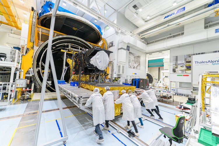
With extreme weather events threatening to be more frequent and more severe as the climate crisis takes grip, it’s never been more important to have fast and accurate forecasts. ESA and Eumetsat are working hard to ensure that there will be a constant stream of weather data from space for the next decades and that these data will arrive faster and be more accurate compared to what we have today. It is therefore fitting that on World Meteorological Day, ESA can be assured that the first of the next generation weather satellites, Meteosat Third Generation Imager, has passed a critical set of tests, paving the way for it to be launched in December.
20220323 - Nefunkční reklamační formuláře
23.3.2022 7:37 ČÚZK /ruian/Novinky-RUIAN/Archiv-novinek-RUIAN/2022/20220323-Nefunkcni-reklamacni-formulareMaxar : Satellite Images, 18-21 March 2022 Ukraine Update
23.3.2022 1:33 GISCafe.com Webcasts-Webinars Imagery gallery details:
Mariupol region:
Images 01-02: Overview of Mariupol with burning buildings from ongoing artillery shelling …
Satellite Images, 19 March 2022: Aftermath of Mariupol Theater Bombing
23.3.2022 0:22 GISCafe.com Webcasts-Webinars Maxar collected new satellite imagery over the weekend (March 19th) of Mariupol, Ukraine that shows the aftermath of the airstrike on the Mariupol …RegioGraph 2022 now available
23.3.2022 0:20 GISCafe.com Webcasts-Webinars Bruchsal, Germany, March 21, 2022 – GfK has released a new version of its geomarketing software RegioGraph. In addition to the latest maps and …SECURA Selects Betterview to Improve Risk Mitigation
22.3.2022 21:37 GISCafe.com Webcasts-Webinars SAN FRANCISCO, March 22, 2022 (GLOBE NEWSWIRE) -- Betterview, an InsurTech provider of actionable property intelligence to property and casualty …Swift Navigation Opens an Office in Japan
22.3.2022 21:37 GISCafe.com Webcasts-Webinars SAN FRANCISCO and TOKYO, March 22, 2022 (GLOBE NEWSWIRE) -- Swift Navigation, a San Francisco-based tech firm redefining GNSS (Global Navigation …Bentley Systems Co-sponsors AASHTO National Bridge and Structure TRAC Competition
22.3.2022 20:05 Bentley SystemsPress Announcements
Qualcomm and Trimble Introduce Meter-Level Location Accuracy for Smartphones
22.3.2022 16:41 GISCafe.com Webcasts-Webinars SUNNYVALE, Calif. and SAN DIEGO, March 22, 2022 — (PRNewswire) — Trimble (NASDAQ: TRMB) and Qualcomm Technologies, Inc. announced today …Turn your phone into a space monitoring tool
22.3.2022 16:30 ESA Navigation
A newly released Android app will turn your smartphone into an instrument for crowdsourced science. Leave it by your window each night with your satnav positioning turned on and your phone will record small variations in satellite signals, gathering data for machine learning analysis of meteorology and space weather patterns.
The world has a water problem, and space may have a solution
22.3.2022 13:50 European GNSS Agency
The world has a water problem. At present, according to the World Health Organisation (WHO) there are 785 million people who lack access to clean water – that’s one in every 10 people on the planet. But the problem goes well beyond the water we drink; it also affects the food we eat. For example, water scarcity, due in part to the increase in droughts caused by climate change, means farmers have less water to grow their crops with.
In parallel, people are increasingly looking to our oceans, lakes and rivers for food – a shift that causes another problem: overfishing. According to some estimates, nearly 30% of all commercially fished species are now considered to be overfished. In the Mediterranean and Black seas, that number is closer to 88%.
With climate change set to exacerbate the water crisis, there’s an urgent need for new solutions.
Two of those solutions are Earth Observation (EO) and Global Navigation Satellite Systems (GNSS).
Go fish
According to the latest edition of the EUSPA EO and GNSS Market Report, Earth Observation is already being used to assess the location of fish stocks and to track the location of vessels in an effort to prevent illegal, unreported and unregulated fishing – an important component of the EU’s Common Fisheries Policy (CFP).
Both Copernicus, for EO, and Galileo, for GNSS, are also being used to support Europe’s growing aquaculture sector. For instance, by providing information and data on environmental conditions and long-term weather forecasts, EO-based applications play a key role in selecting ideal locations to establish aquafarms. Once the aquafarm is up and running, Copernicus, together with Galileo, is used to optimise operations and provide aquafarmers with a wide range of insight and information.
Keeping an eye on our oceans’ health
While sustainable fisheries and aquaculture are important to securing food production, and are key components to the European Union’s Green Deal, they both depend on having healthy oceans. Here too, GNSS and especially EO play an important role.
Oceans, which account for about 71% of the Earth’s surface, are at the centre of climate change. That’s because oceans act as a natural carbon sink, essentially absorbing much of the carbon being emitted into the atmosphere. As the oceans absorb more carbon, their temperatures go up, which can lead to a whole host of problems, including rising sea levels, changes in fish migration, the killing of coral reefs and alterations to the world’s climate patterns.
To mitigate these issues, the Copernicus Marine and Climate Change Services monitor a number of key climate indicators, such as sea level, temperature, currents and salinity. This data can then be used to drive global climate policy decisions.

Phytoplankton are microscopic plants that grow in the sunlit surface waters of the ocean. When their concentration reaches a certain level, the bloom becomes visible from space.
For freshwater too
EO’s usefulness doesn’t stop with salt water, it’s being used to monitor the quality of freshwater sources too. Today, scientists and policymakers regularly use data coming from Copernicus satellites to, for example, measure water surface temperature, which can tell us a lot about a lake or river’s overall health.
This same data can be used to track how rising global temperatures and more extreme weather events increase a body of water’s acidity, cause a build-up of pathogens, and change its nutrient concentration. And because quality freshwater is essential to drinking water, this same data can play a key role in achieving the United Nations Sustainable Development Goal of ensuring access to water and sanitation for all
So on this World Water Day, as you’re enjoying a fresh glass of H2O, be sure to look up and remember how space-based solutions are working to ensure the healthy climate, healthy oceans, and healthy freshwater systems that make our water sustainable, safe and sanitary.
Media note: This feature can be republished without charge provided the European Union Agency for the Space Programme (EUSPA) is acknowledged as the source at the top or the bottom of the story. You must request permission before you use any of the photographs on the site. If you republish, we would be grateful if you could link back to the EUSPA website (https://www.euspa.europa.eu).
The world has a water problem, and space may have a solution
22.3.2022 13:50 European GNSS AgencyThe world has a water problem. At present, according to the World Health Organisation (WHO) there are 785 million people who lack access to clean water – that’s one in every 10 people on the planet. But the problem goes well beyond the water we drink; it also affects the food we eat. For example, water scarcity, due in part to the increase in droughts caused by climate change, means farmers have less water to grow their crops with.
In parallel, people are increasingly looking to our oceans, lakes and rivers for food – a shift that causes another problem: overfishing. According to some estimates, nearly 30% of all commercially fished species are now considered to be overfished. In the Mediterranean and Black seas, that number is closer to 88%.
With climate change set to exacerbate the water crisis, there’s an urgent need for new solutions.
Two of those solutions are Earth Observation (EO) and Global Navigation Satellite Systems (GNSS).
Go fish
According to the latest edition of the EUSPA EO and GNSS Market Report, Earth Observation is already being used to assess the location of fish stocks, while GNSS is used to track the location of vessels in an effort to prevent illegal, unreported and unregulated fishing – an important component of the EU’s Common Fisheries Policy (CFP).
Both Copernicus, for EO, and Galileo, for GNSS, are also being used to support Europe’s growing aquaculture sector. For instance, by providing information and data on environmental conditions and long-term weather forecasts, EO-based applications play a key role in selecting ideal locations to establish aquafarms. Once the aquafarm is up and running, Copernicus, together with Galileo, is used to optimise operations and provide aquafarmers with a wide range of insight and information.
Keeping an eye on our oceans’ health
While sustainable fisheries and aquaculture are important to securing food production, and are key components to the European Union’s Green Deal, they both depend on having healthy oceans. Here too, GNSS and especially EO play an important role.
Oceans, which account for about 71% of the Earth’s surface, are at the centre of climate change. That’s because oceans act as a natural carbon sink, essentially absorbing much of the carbon being emitted into the atmosphere. As the oceans absorb more carbon, their temperatures go up, which can lead to a whole host of problems, including rising sea levels, changes in fish migration, the killing of coral reefs and alterations to the world’s climate patterns.
To mitigate these issues, the Copernicus Marine and Climate Change Services monitor a number of key climate indicators, such as sea level, temperature, currents and salinity. This data can then be used to drive global climate policy decisions.
Phytoplankton are microscopic plants that grow in the sunlit surface waters of the ocean. When their concentration reaches a certain level, the bloom becomes visible from space.
For freshwater too
EO’s usefulness doesn’t stop with salt water, it’s being used to monitor the quality of freshwater sources too. Today, scientists and policymakers regularly use data coming from Copernicus satellites to, for example, measure water surface temperature, which can tell us a lot about a lake or river’s overall health.
This same data can be used to track how rising global temperatures and more extreme weather events increase a body of water’s acidity, cause a build-up of pathogens, and change its nutrient concentration. And because quality freshwater is essential to drinking water, this same data can play a key role in achieving the United Nations Sustainable Development Goal of ensuring access to water and sanitation for all
So on this World Water Day, as you’re enjoying a fresh glass of H2O, be sure to look up and remember how space-based solutions are working to ensure the healthy climate, healthy oceans, and healthy freshwater systems that make our water sustainable, safe and sanitary.
Media note: This feature can be republished without charge provided the European Union Agency for the Space Programme (EUSPA) is acknowledged as the source at the top or the bottom of the story. You must request permission before you use any of the photographs on the site. If you republish, we would be grateful if you could link back to the EUSPA website (https://www.euspa.europa.eu).
Satellite navigation signals help map sea surface shape
22.3.2022 12:30 ESA Navigation Video:
00:05:00
Video:
00:05:00
Monitoring the constantly changing shape of the sea surface is important for scientific and societal applications such as ocean current forecasting, climate research, ship routing, cable laying, and debris tracking.
A project supported by the Discovery element of ESA’s Basic Activities recently investigated a new technique to measure sea surface topography very precisely. The project was based on an idea submitted by the Institute for Space Studies of Catalonia (IEEC) through the Open Space Innovation Platform (OSIP) – ESA’s place for your space ideas.
The technique involves looking at satellite navigation (GNSS) signals that have been reflected off of the sea surface at very low angles. At these so-called grazing angles, waves and surface roughness have very little impact on the reflection process; the sea surface acts as a very smooth mirror.
IEEC’s Estel Cardellach, principal investigator and submitter of the OSIP idea explains: “In a mirror-like reflection the phase of the signal can be tracked – it is continuous. Different surface heights result in different phase measurements. It gives a very precise measurement of the surface altitude at a few centimetres’ precision.”
The ESA-funded activity involved developing a GNSS receiver and setting up an experiment in the Balaeric Islands to collect GNSS signals reflected off the sea surface. The team – made up of IEEC, imedea, SOCIB and DLR – then processed the signals for optimised measurements of the shape of the sea surface.
“Thanks to OSIP and ESA Discovery we have been able to conduct this experiment on grazing GNSS reflectometry under monitored conditions,” says Manuel Martin-Neira, ESA technical officer for the project. “We have linked the coherence of the reflected signals to wave height and elevation angle of GNSS satellites. These results have been very useful for preparing the PRETTY mission.”
ESA’s PRETTY (Passive REflecTomeTry and dosimetry) CubeSat mission is a small satellite that will carry out grazing angle GNSS altimetry from orbit. It is due to launch later in 2022.
Den s CAD/PDM expertem – bezplatná konzultace pro vaši firmu
22.3.2022 8:00 Arkance SystemsVyužijte nové akce společnosti Arkance Sytems a přihlaste se co nejdříve!
Zpráva Den s CAD/PDM expertem – bezplatná konzultace pro vaši firmu pochází z arkance-systems.cz.
Smutná zpráva - prof. Martin Hampl zemřel [Knihovna geografie, byTopic]
22.3.2022 0:00 Katedra aplikované geoinformatiky a kartografie Přf UK V pondělí 21. března 2022 zemřel ve věku 81 let prof. Martin Hampl, nestor české geografie a zakladatel albertovské školy, náš vzácný kolega a Učitel celých generací geografů. Čest jeho památce!Atlas Technical Consultants Acquires 1 Alliance Geomatics
21.3.2022 23:16 GISCafe.com Webcasts-Webinars AUSTIN, Texas, March 21, 2022 (GLOBE NEWSWIRE) -- Atlas Technical Consultants, Inc. (Nasdaq: ATCX) (“Atlas” or the “Company”), …Práca ESPRIT: Programátor GIS aplikácií
21.3.2022 20:42 Geocommunity.skPríspevok Práca ESPRIT: Programátor GIS aplikácií zobrazený najskôr GeoCommunity.eu.
Práca ESPRIT: Programátor GIS aplikácií
21.3.2022 20:42 Geocommunity.skPríspevok Práca ESPRIT: Programátor GIS aplikácií zobrazený najskôr GeoCommunity.sk.
Moving Towards Decarbonized Infrastructure Interview with Rodrigo Fernandes from Bentley Systems
21.3.2022 20:37 Bentley SystemsPressCoverage
DirectIndustry, France
Read the articlePelicanCorp Announces Integration With the Spatial Distillery Co.
21.3.2022 16:26 GISCafe.com Webcasts-Webinars IRVINE, Calif., March 21, 2022 (GLOBE NEWSWIRE) -- PelicanCorp Inc., the global leader in underground assets damage prevention solutions, today …Fortress UAV Introduces New Drone-In-A-Box Operational Challenges Whitepaper
21.3.2022 16:26 GISCafe.com Webcasts-Webinars PLANO, Texas — (BUSINESS WIRE) — March 21, 2022 —Fortress UAV, the leader and most advanced partner for UAS deployment and …
Ursa Space Raises $16 Million in Series C Funding to Accelerate Time-to-Insight for Customers in the Satellite Intelligence Market
21.3.2022 16:26 GISCafe.com Webcasts-Webinars ITHACA, N.Y., March 21, 2022 — (PRNewswire) — Ursa Space, the global satellite intelligence infrastructure company, announced the first …MO Technologies Chooses Esri's ArcGIS Platform to Support Alternative Credit Scoring Tool
21.3.2022 16:26 GISCafe.com Webcasts-Webinars New Product Uses Esri Data and Geocoding to Expand Financial Services to Underserved MarketsREDLANDS, Calif. — (BUSINESS WIRE) — March …
Intermap Closes Private Placement
21.3.2022 16:26 GISCafe.com Webcasts-Webinars DENVER, March 21, 2022 — (PRNewswire) — Intermap Technologies (TSX: IMP) (OTCQX: ITMSF) ("Intermap" or the "Company"), a global leader …Rivada Space Networks launches new low earth orbit constellation at Satellite 2022
21.3.2022 16:26 GISCafe.com Webcasts-Webinars WASHINGTON, March 21, 2022 — (PRNewswire) —Satellite and terrestrial communications converge in innovative connectivity network
…
Satellogic and HFX Collaborate to Equip Ukraine with Satellite Tasking Capabilities
21.3.2022 16:26 GISCafe.com Webcasts-Webinars Ukraine to receive direct control of imaging satellites for enhanced intelligence and scalable monitoring of military movements, safety corridors, …JOIN and DMP to Invest up to €80.5 Million to Create High-Definition Map in Europe
21.3.2022 16:26 GISCafe.com Webcasts-Webinars Ushr Parent Company, Dynamic Map Platform, to Leverage Funding for Expanded CoverageDETROIT — (BUSINESS WIRE) — March 21, 2022 …
DRONEDEK and Alpine 4 Holdings Subsidiary, Vayu Aerospace Corporation, Partner to Create a New Ecosystem for Drone Delivery
21.3.2022 16:26 GISCafe.com Webcasts-Webinars INDIANAPOLIS, March 21, 2022 — (PRNewswire) — DRONEDEK, known for its "mailbox of the future," is working with Alpine 4 …20220321 - VŘ Správce DMVS
21.3.2022 14:13 ČÚZK - předpisy a opatření Český úřad zeměměřický a katastrální zveřejnil novou aktualitu: Oznámení o vyhlášení výběrového řízení na obsazení služebního místa odborný rada - Správce digitální mapy veřejné správy.20220321 - VŘ Správce DMVS
21.3.2022 14:13 ČÚZK - aktuality v resortu Oznámení o vyhlášení výběrového řízení na obsazení služebního místa odborný rada - Správce digitální mapy veřejné správy.Odborný rada - Správce digitální mapy veřejné správy
21.3.2022 14:01 ČÚZK - volná místa Český úřad zeměměřický a katastrální vypisuje výběrové řízení na místo Odborný rada - Správce digitální mapy veřejné správyOdborný rada - Správce digitální mapy veřejné správy
21.3.2022 14:01 ČÚZK /Urady/Cesky-urad-zememericky-a-katastralni/Uredni-deska/Oznameni-a-jina-uredni-sdeleni/Volna-mista/DMS/Odborny-rada-Spravce-digitalni-mapy-verejne-spraOdborný rada - Správce digitální mapy veřejné správy
21.3.2022 14:01 ČÚZK - předpisy a opatření Český úřad zeměměřický a katastrálnívypisuje výběrové řízení na místo
Odborný rada - Správce digitální mapy veřejné správy
Methane detected over Poland’s coal mines
21.3.2022 12:30 ESA Observing the Earth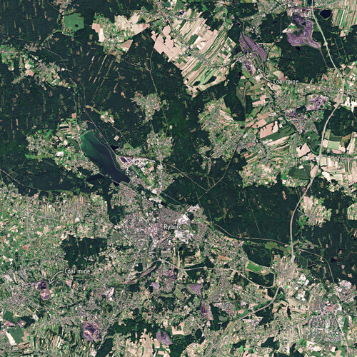
Data from the Tropomi instrument onboard the Copernicus Sentinel-5P satellite has been used to detect methane plumes over some of Europe’s largest methane-emitting coal mines.
Převodník z Konfigurátoru korpusů a kování firmy BLUM
21.3.2022 11:49 ŠPINAR - softwareVážení zákazníci,
nový převodník Konfigurátoru korpusů od firmy Blum do DAEX DESIGN Vám ulehčí Vaší práci.
The post Převodník z Konfigurátoru korpusů a kování firmy BLUM appeared first on ŠPINAR – software.
Převodník z Konfigurátoru korpusů a kování firmy BLUM
21.3.2022 11:49 ŠPINAR - softwareVážení zákazníci,
nový převodník Konfigurátoru korpusů od firmy Blum do DAEX DESIGN Vám ulehčí Vaší práci.
The post Převodník z Konfigurátoru korpusů a kování firmy BLUM appeared first on ŠPINAR – software.
DAEX Importér – převodník dat z Konfigurátoru korpusů od firmy BLUM
21.3.2022 11:49 ŠPINAR - softwareVážení zákazníci,
nový převodník Konfigurátoru korpusů od firmy Blum do DAEX DESIGN Vám ulehčí Vaší práci.
The post DAEX Importér – převodník dat z Konfigurátoru korpusů od firmy BLUM appeared first on ŠPINAR – software.
Převodník z Konfigurátoru korpusů a kování firmy BLUM
21.3.2022 11:49 ŠPINAR - software Vážení zákazníci,převodník Konfigurátoru korpusů od firmy Blum do DAEX DESIGN Vám ulehčí Vaší práci a k DAEX DESIGEN jej nyní můžete získat do 31. 3. 2022 zdarma.
Převodník z Konfigurátoru korpusů a kování firmy BLUM
21.3.2022 11:49 ŠPINAR - softwareVážení zákazníci,
převodník Konfigurátoru korpusů od firmy Blum do DAEX DESIGN Vám ulehčí Vaší práci a k DAEX DESIGEN jej nyní můžete získat do 31. 3. 2022 zdarma.
The post Převodník z Konfigurátoru korpusů a kování firmy BLUM appeared first on ŠPINAR – software.
Převodník dat z Konfigurátoru korpusů od firmy BLUM
21.3.2022 11:49 ŠPINAR - softwareVážení zákazníci,
nový převodník Konfigurátoru korpusů od firmy Blum do DAEX DESIGN Vám ulehčí Vaší práci.
The post Převodník dat z Konfigurátoru korpusů od firmy BLUM appeared first on ŠPINAR – software.
Změna otevírací doby knihovny [Knihovna geografie, byTopic]
21.3.2022 10:55 Katedra aplikované geoinformatiky a kartografie Přf UK Z provozních důvodů bohužel musíme uzavřít Knihovnu geografie v pondělí 21.03.2022 a ve středu 23.03.2022 od 16,00-do 18,00. Děkujeme za pochopení.Rozpočet úřadu za rok 2022
21.3.2022 7:12 ČÚZK /Urady/Zememericke-a-katastralni-inspektoraty/Zememericke-a-katastralni-inspektoraty/Zememericky-a-katastralni-inspektorat-v-Brne/Rozpocet/Rozpocet-uradu-za-rok-2022Rozpočet úřadu za rok 2022
21.3.2022 7:12 ČÚZK - předpisy a opatření Zeměměřický a katastrální inspektorát v Brněvystavuje rozpočet úřadu za rok
2022
Výsledky súťaže študentských prác na konferencii GISáček 2022
19.3.2022 19:00 Geocommunity.skPríspevok Výsledky súťaže študentských prác na konferencii GISáček 2022 zobrazený najskôr GeoCommunity.eu.
Výsledky súťaže študentských prác na konferencii GISáček 2022
19.3.2022 19:00 Geocommunity.skPríspevok Výsledky súťaže študentských prác na konferencii GISáček 2022 zobrazený najskôr GeoCommunity.sk.
"Missouri Department of Health Uses GIS to Track COVID-19 Viral Load in Wastewater" by Susan Smith
19.3.2022 8:46 GISCafe.com Webcasts-WebinarsThe best time to invest in space – EUSPA launches info session for fund managers
18.3.2022 16:21 European GNSS Agency
The best time to invest in space – EUSPA launches info session for fund managers.
According to the latest edition of the EUSPA EO and GNSS Market Report, in 2021, the GNSS and Earth Observation downstream market generated over EUR 200 billion in revenue.
What’s more, this market is expected to reach nearly half a trillion euros within the next decade. Add this up and what you have is a very lucrative investment opportunity.
But to take advantage of this opportunity, you need the right information and the right market intelligence – which is exactly what the Space Investments Capacity Building Programme is set to provide.
Organised by the European Union Agency for the Space Programme (EUSPA), in collaboration with the European Commission, European Space Agency (ESA) and European Investment Fund (EIF), this series of five workshops is designed to provide venture capitalists, fund managers and other investors with in-depth information on the space sector, including:
- Results from the latest European space market and investment studies
- Advice from the EIF on fund setup, investment strategy and building an investment team
- A platform to discuss business models and best practices
- Opportunities to network with other fund managers
- Details on the European Commission’s EUR 1 billion CASSINI Facility, an InvestEU initiative offering capital for establishing space-focused investment funds
The first workshop, scheduled for 28 March 2022 from 14:00 – 17:00 CET, will focus on how EU space technology – including Galileo and Copernicus – can be used to support the construction sector, optimise the green transformation and maintain critical infrastructure.
“If you want to become an active investor in this exciting field or simply want to gather more information before deciding to raise a new fund, then this capacity building programme is for you”, says Fiammetta Diani, EUSPA Head of Market Downstream and Innovation.
The event will be held live at EUSPA’s headquarters in Prague, as well as online. Attendance is free, but registration is required. For participants able to attend physically in Prague, please send an email to market@euspa.europa.eu to secure your place in the venue. Questions related to the workshop series or requests for additional information can be directed to this email address as well.
Mark Your Calendars: Space Investments Capacity Building Programme 2022
- Episode 1: Infrastructure lifecycle support from space, EUSPA, Prague, Monday 28 March 2022
- Episode 2: Security and defence (in and from space), COM, Brussels, Monday 2 May 2022
- Episode 3: Consumer space solutions: well-being, education and entertainment, EUSPA, Prague, Monday 23 May 2022
- Episode 4: Access to space (launchers, ground systems, modular technology, etc), ESA, Paris, Tuesday 7 June 2022
- Episode 5: Fund setup, investment strategy, investment team, exit strategy, EIF, Luxemburg, Monday 27 June 2022
Media note: This feature can be republished without charge provided the European Union Agency for the Space Programme (EUSPA) is acknowledged as the source at the top or the bottom of the story. You must request permission before you use any of the photographs on the site. If you republish, we would be grateful if you could link back to the EUSPA website (http://www.euspa.europa.eu).
The best time to invest in space – EUSPA launches info session for fund managers
18.3.2022 16:21 European GNSS AgencyThe best time to invest in space – EUSPA launches info session for fund managers.
According to the latest edition of the EUSPA EO and GNSS Market Report, in 2021, the GNSS and Earth Observation downstream market generated over EUR 200 billion in revenue.
What’s more, this market is expected to reach nearly half a trillion euros within the next decade. Add this up and what you have is a very lucrative investment opportunity.
But to take advantage of this opportunity, you need the right information and the right market intelligence – which is exactly what the Space Investments Capacity Building Programme is set to provide.
Organised by the European Union Agency for the Space Programme (EUSPA), in collaboration with the European Commission, European Space Agency (ESA) and European Investment Fund (EIF), this series of five workshops is designed to provide venture capitalists, fund managers and other investors with in-depth information on the space sector, including:
- Results from the latest European space market and investment studies
- Advice from the EIF on fund setup, investment strategy and building an investment team
- A platform to discuss business models and best practices
- Opportunities to network with other fund managers
- Details on the European Commission’s EUR 1 billion CASSINI Facility, an InvestEU initiative offering capital for establishing space-focused investment funds
The first workshop, scheduled for 28 March 2022 from 14:00 – 17:00 CET, will focus on how EU space technology – including Galileo and Copernicus – can be used to support the construction sector, optimise the green transformation and maintain critical infrastructure.
“If you want to become an active investor in this exciting field or simply want to gather more information before deciding to raise a new fund, then this capacity building programme is for you”, says Fiammetta Diani, EUSPA Head of Market Downstream and Innovation.
The event will be held live at EUSPA’s headquarters in Prague, as well as online. Attendance is free, but registration is required. For participants able to attend physically in Prague, please send an email to market@euspa.europa.eu to secure your place in the venue. Questions related to the workshop series or requests for additional information can be directed to this email address as well.
Mark Your Calendars: Space Investments Capacity Building Programme 2022
- Episode 1: Infrastructure lifecycle support from space, EUSPA, Prague, Monday 28 March 2022
- Episode 2: Security and defence (in and from space), COM, Brussels, Monday 2 May 2022
- Episode 3: Consumer space solutions: well-being, education and entertainment, EUSPA, Prague, Monday 23 May 2022
- Episode 4: Access to space (launchers, ground systems, modular technology, etc), ESA, Paris, Tuesday 7 June 2022
- Episode 5: Fund setup, investment strategy, investment team, exit strategy, EIF, Luxemburg, Monday 27 June 2022
Media note: This feature can be republished without charge provided the European Union Agency for the Space Programme (EUSPA) is acknowledged as the source at the top or the bottom of the story. You must request permission before you use any of the photographs on the site. If you republish, we would be grateful if you could link back to the EUSPA website (http://www.euspa.europa.eu).
Intermap Supports Ukraine's Ministry of Defense with High-Resolution, 3D Elevation Data and Analytic Services
18.3.2022 16:05 GISCafe.com Webcasts-Webinars DENVER, CO, March 18, 2022 — (PRNewswire) — Intermap Technologies (TSX: IMP) (OTCQX: ITMSF) ("Intermap" or the "Company"), a global …20220318 - VŘ Řízení projektů
18.3.2022 14:52 ČÚZK - aktuality v resortu Oznámení o vyhlášení výběrového řízení na obsazení služebního místa odborný rada - Řízení projektů.20220318 - VŘ Řízení projektů
18.3.2022 14:52 ČÚZK /Aktuality-resort/2022/20220318-VR-Rizeni-projektu20220318 - VŘ Řízení projektů
18.3.2022 14:52 ČÚZK - předpisy a opatření Český úřad zeměměřický a katastrální zveřejnil novou aktualitu: Oznámení o vyhlášení výběrového řízení na obsazení služebního místa odborný rada - Řízení projektů.20220318 - VŘ Podpora uživatelů
18.3.2022 14:50 ČÚZK - aktuality v resortu Oznámení o vyhlášení výběrového řízení na obsazení služebního místa odborný/vrchní referent - Podpora uživatelů.20220318 - VŘ Podpora uživatelů
18.3.2022 14:50 ČÚZK /Aktuality-resort/2022/20220318-VR-Podpora-uzivatelu20220318 - VŘ Podpora uživatelů
18.3.2022 14:50 ČÚZK - předpisy a opatření Český úřad zeměměřický a katastrální zveřejnil novou aktualitu: Oznámení o vyhlášení výběrového řízení na obsazení služebního místa odborný/vrchní referent - Podpora uživatelů.Odborný rada - Řízení projektů
18.3.2022 14:26 ČÚZK - volná místa Český úřad zeměměřický a katastrální vypisuje výběrové řízení na místo Odborný rada - Řízení projektůOdborný rada - Řízení projektů
18.3.2022 14:26 ČÚZK /Urady/Cesky-urad-zememericky-a-katastralni/Uredni-deska/Oznameni-a-jina-uredni-sdeleni/Volna-mista/DMS/Odborny-rada-Rizeni-projektuOdborný rada - Řízení projektů
18.3.2022 14:26 ČÚZK - předpisy a opatření Český úřad zeměměřický a katastrálnívypisuje výběrové řízení na místo
Odborný rada - Řízení projektů
GISáček 2022 (výsledky)
18.3.2022 13:41 GISportal.cz
Dňa 18.3.2022 sa konala študentská súťaž GISáček. Toto podujatie je primárne určené študentom vysokých škôl, ktorí sa v rámci svojich bakalárskych (Bc.) a magisterských (Mgr.) prác venujú témam z oblasti geoinformatiky, geoinformačných technológií a ich aplikácií. Na podujatí sa tradične schádzame na pôde VŠB-TUO, no aktuálny ročník prebehol podobne ako predchádzajúci v online režime. Jednotlivé […]
The post GISáček 2022 (výsledky) appeared first on GISportal.cz.
GISáček 2022 (výsledky)
18.3.2022 13:41 GISportal.czDňa 18.3.2022 sa konala študentská súťaž GISáček. Toto podujatie je primárne určené študentom vysokých škôl, ktorí sa v rámci svojich bakalárskych (Bc.) a magisterských (Mgr.) prác venujú témam z oblasti geoinformatiky, geoinformačných technológií a ich aplikácií. Na podujatí sa tradične schádzame na pôde VŠB-TUO, no aktuálny ročník prebehol podobne ako predchádzajúci v online režime. Jednotlivé […]
The post GISáček 2022 (výsledky) appeared first on GISportal.cz.
Odborný referent v oddělení dokumentace KN na Katastrálním pracovišti Znojmo
18.3.2022 12:44 ČÚZK - předpisy a opatření Katastrální úřad pro Jihomoravský kraj Katastrální pracoviště Znojmovypisuje výběrové řízení na místo
Odborný referent v oddělení dokumentace KN na Katastrálním pracovišti Znojmo
Odborný referent v oddělení dokumentace KN na Katastrálním pracovišti Znojmo
18.3.2022 12:44 ČÚZK - volná místa Katastrální úřad pro Jihomoravský kraj Katastrální pracoviště Znojmo vypisuje výběrové řízení na místo Odborný referent v oddělení dokumentace KN na Katastrálním pracovišti ZnojmoOdborný referent v oddělení dokumentace KN na Katastrálním pracovišti Znojmo
18.3.2022 12:44 ČÚZK /Urady/Katastralni-urady/Katastralni-urady/Katastralni-urad-pro-Jihomoravsky-kraj/Volna-mista/DMS/Odborny-referent-v-oddeleni-dokumentace-KN-na-KataBroadGNSS Request for Tender now open, deadline is 2 May 2022
18.3.2022 11:57 European GNSS Agency project which will procure Innovation activity for Applications, Synchronisation and Monitoring of Critical Mobile Broadband Communication Infrastructure and Information Assets for Public Protection and Disaster Recovery (PPDR) Operations.")
BroadGNSS, the Pre-Commercial Procurement action funded by the European Union Agency for the Space Programme (EUSPA), moves into the Request for Tender phase.
Launched in December 2020, the EUSPA-funded BroadGNSS project has dedicated EUR 2.5 million for the pre-commercial procurement (PCP) of innovative solutions that use European GNSS (EGNSS) to improve public safety and disaster relief services.
As the Contract Notice has been published in the Official Journal of the European Union (OJEU), BroadGNSS now moves into the Request for Tender (RFT) phase.
Download: BroadGNSS RFT documents (available in English and French)
With the 2 May 2022 deadline fast approaching, the project recently held informational briefings. The events focused on preparing and submitting the tender, along with providing an overview of how received tenders will be evaluated.
Anyone considering submitting a tender should be sure to add their company name to the BroadGNSS Partnering Tool. This tool is a convenient way for potential consortium members to share information on both the expertise they offer and the expertise they require.
Once registered, you can start browsing other listed companies. When you see a company that you want to contact, simply send a message via the Contact Page specifying the name of the company you want to contact. You will receive the requested information within two business days.
A maximum of 10 (and a minimum of four) suppliers/supply teams will be selected based on the evaluation of the tenders to be submitted by the 2nd of May 2022, with a joint framework agreement and contract for the Design Phase to follow.
The Contract Notice can be viewed in full on TED.
More details on the PCP process can be found here.
Media note: This feature can be republished without charge provided the European Union Agency for the Space Programme (EUSPA) is acknowledged as the source at the top or the bottom of the story. You must request permission before you use any of the photographs on the site. If you republish, we would be grateful if you could link back to the EUSPA website (http://www.euspa.europa.eu).
BroadGNSS Request for Tender now open, deadline is 2 May 2022
18.3.2022 11:57 European GNSS AgencyBroadGNSS, the Pre-Commercial Procurement action funded by the European Union Agency for the Space Programme (EUSPA), moves into the Request for Tender phase.
Launched in December 2020, the EUSPA-funded BroadGNSS project dedicates EUR 2.1 million for the pre-commercial procurement (PCP) of innovative solutions that use European GNSS (EGNSS) to improve public safety and disaster relief services.
BroadGNSS now moves into the Request for Tender (RFT) phase.
Download: BroadGNSS RFT documents (available in English and French)
With the 2 May 2022 deadline fast approaching for the submission of tenders, the project recently held informational briefings. The events focused on preparing and submitting the tender, along with providing an overview of how received tenders will be evaluated.
The project puts also at your disposal the BroadGNSS Partnering Tool. This tool is a convenient way for companies to share information on both the expertise they offer and the expertise they require to build up consortia.
The Group of Procurers will then evaluate the tenders submitted and a maximum of 10 (and a minimum of four) suppliers/supply teams will be selected.
The Contract Notice can be viewed in full on TED.
To submit your tender: https://www.marches-publics.gouv.fr/app.php/entreprise/consultation/1973325?orgAcronyme=g6l.
More details on the PCP process can be found here.
Media note: This feature can be republished without charge provided the European Union Agency for the Space Programme (EUSPA) is acknowledged as the source at the top or the bottom of the story. You must request permission before you use any of the photographs on the site. If you republish, we would be grateful if you could link back to the EUSPA website (http://www.euspa.europa.eu).
20220318_Odborný referent oddělení právních vztahů k nemovitostem
18.3.2022 10:52 ČÚZK - předpisy a opatření Katastrální úřad pro Středočeský kraj - Katastrální pracoviště Kladno Vyhlášení výběrového řízení: Odborný referent oddělení právních vztahů k nemovitostem V části "Úřední deska", v sekci "Oznámení a jiná úřední sdělení" bylo vystaveno "Oznámení o vyhlášení výběrového řízení na obsazení systemizovaného místa Odborný referent oddělení právních vztahů k nemovitostem"20220318_Odborný referent oddělení právních vztahů k nemovitostem
18.3.2022 10:52 ČÚZK /Urady/Katastralni-urady/Katastralni-urady/Katastralni-urad-pro-Stredocesky-kraj/Katastralni-pracoviste/KP-Kladno/O-uradu/Aktuality/20220318_Odborny-referent-oddeleni-pravnich-vztahuOdborný referent oddělení právních vztahů k nemovitostem
18.3.2022 10:49 ČÚZK - volná místa Katastrální úřad pro Středočeský kraj - Katastrální pracoviště Kladno vypisuje výběrové řízení na místo Odborný referent oddělení právních vztahů k nemovitostemOdborný referent oddělení právních vztahů k nemovitostem
18.3.2022 10:49 ČÚZK - předpisy a opatření Katastrální úřad pro Středočeský kraj - Katastrální pracoviště Kladnovypisuje výběrové řízení na místo: Odborný referent oddělení právních vztahů k nemovitostem
Odborný referent oddělení právních vztahů k nemovitostem
Earth from Space: Lake Nasser, Egypt
18.3.2022 10:00 ESA Observing the Earth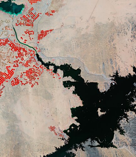
Part of Lake Nasser, one of the largest artificial lakes in the world, is featured in this false-colour image captured by the Copernicus Sentinel-2 mission.
Autodesk to Present at Upcoming Investor Conference
18.3.2022 8:00 GISCafe.com Webcasts-Webinars SAN FRANCISCO, March 15, 2022 — (PRNewswire) — Autodesk, Inc. (NASDAQ: ADSK) today announced its executives will present on …Mapware New Subscription Plans: Same Advanced Photogrammetry, Even Better Value
18.3.2022 8:00 GISCafe.com Webcasts-Webinars New plans to fit every need -- from individual drone operators, to small teams and agencies, to large enterprises with critical, high-volume business …Satellite Images, 16 March 2022: Mariupol theater writing on pavement saying "Children" and update of Ukraine
17.3.2022 20:42 GISCafe.com Webcasts-Webinars Closer view of mariupol theater_before bombing_word_children on pavementMariupol theater_before bombing_word_children on pavement
The Occupant Movement Analysis project team have achieved an important milestone on their project. They have documented the process maps of the first phase onto the use case management tool.
17.3.2022 20:01 buildingSMART.orgThese are the deliverables of the first phase, which will be used as a basis for the second phase. To view the documents in the UCM system please use the following links: 1. Circulation Analysis – International https://ucm.buildingsmart.org/use-case-details/2551/en Evacuation Analysis – International https://ucm.buildingsmart.org/use-case-details/2424/en Evacuation Analysis – RIBA https://ucm.buildingsmart.org/use-case-details/2436/en
The post The Occupant Movement Analysis project team have achieved an important milestone on their project. They have documented the process maps of the first phase onto the use case management tool. appeared first on buildingSMART International.
The Occupant Movement Analysis project team have achieved an important milestone on their project. They have documented the process maps of the first phase onto the use case management tool.
17.3.2022 20:01 buildingSMART.orgThese are the deliverables of the first phase, which will be used as a basis for the second phase. To view the documents in the UCM system please use the following links: 1. Circulation Analysis – International https://ucm.buildingsmart.org/use-case-details/2551/en 2. Evacuation Analysis – International https://ucm.buildingsmart.org/use-case-details/2424/en 3. Evacuation Analysis – RIBA https://ucm.buildingsmart.org/use-case-details/2436/en Go to document
The post The Occupant Movement Analysis project team have achieved an important milestone on their project. They have documented the process maps of the first phase onto the use case management tool. appeared first on buildingSMART International.
Bentley Systems Recognized as the Microsoft Asia Pacific Region Social Impact
17.3.2022 19:58 Bentley SystemsPress Announcements