


zprávy
zdroje zpráv:rada / odborný rada v oddělení obnovy katastrálního operátu v technickém odboru
30.3.2021 13:17 ČÚZK - předpisy a opatření Katastrální úřad pro Liberecký kraj - technický odborvypisuje výběrové řízení na místo
rada / odborný rada v oddělení obnovy katastrálního operátu v technickém odboru
Second Scout gets the go-ahead
30.3.2021 9:55 ESA Observing the Earth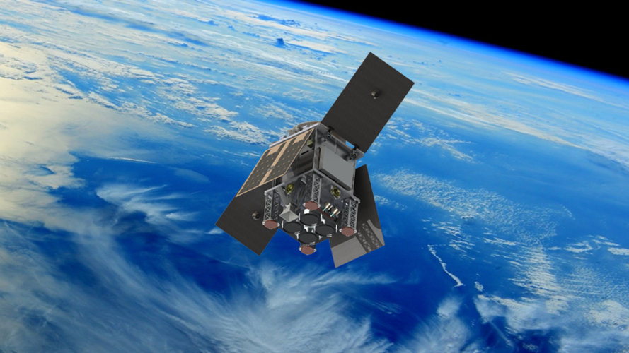
Following the selection of the first Scout satellite mission last December, ESA has also given the greenlight to start negotiations with Surrey Satellite Technology Ltd in the UK to lead the development of the second Scout mission – HydroGNSS.
Bad Elf and Point One partner to provide Polaris GNSS corrections for Bad Elf Flex®
30.3.2021 9:00 GISCafe.com Webcasts-Webinars Scottsdale, AZ, USA – March 30, 2021 – Bad Elf, LLC and Point One Navigation, Inc. announce a strategic relationship to provide …Přerušení provozu DP a WSDP ve čtvrtek 1.4.2021 a v neděli 4.4.2021
30.3.2021 8:07 ČÚZK /Aplikace-DP-do-KN/Aplikace-DP-do-KN/Archiv-DP/317008Přerušení provozu DP a WSDP ve čtvrtek 1.4.2021 a v neděli 4.4.2021
30.3.2021 8:07 Dálkový přístup k údajům KN ČR Vážení uživatelé,oznamujeme, že ve čtvrtek 1.4.2021 od 16:30 do cca 22:00 a v neděli 4.4.2021 v průběhu dne bude z provozních důvodů zcela přerušen provoz Dálkového přístupu i Webových služeb dálkového přístupu. V rámci přerušení provozu nebudou instalovány žádné opravy ani nová funkčnost, odstávky jsou způsobeny pracemi na technologické infrastruktuře.
Za komplikace tímto způsobené se omlouváme a děkujeme za pochopení.
Přerušení provozu DP a WSDP ve čtvrtek 1.4.2021 a v neděli 4.4.2021
30.3.2021 8:07 ČÚZK - předpisy a opatření Vážení uživatelé,oznamujeme, že ve čtvrtek 1.4.2021 od 16:30 do cca 22:00 a v neděli 4.4.2021 v průběhu dne bude z provozních důvodů zcela přerušen provoz Dálkového přístupu i Webových služeb dálkového přístupu. V rámci přerušení provozu nebudou instalovány žádné opravy ani nová funkčnost, odstávky jsou způsobeny pracemi na technologické infrastruktuře.
Za komplikace tímto způsobené se omlouváme a děkujeme za pochopení.
Velodyne Lidar Files Form S-1 Registration Statement to Register Existing Shares from the Previously Completed Merger Upon Release of the Lock-Up
30.3.2021 3:32 GISCafe.com Webcasts-Webinars Approximately Two-Thirds of Registered Shares Remain Locked-UpSAN JOSE, Calif. — (BUSINESS WIRE) — March 29, 2021 —
Velodyne …
CIOE-Intelligent Sensing Expo to promote industrial development
30.3.2021 3:32 GISCafe.com Webcasts-Webinars SHENZHEN, China, March 30, 2021 — (PRNewswire) — As one of the 6 expos in CIOE, Intelligent Sensing Expo focuses on new products, …SPÚ odvedl v roce 2020 do státního rozpočtu 549 miliónů za prodej pozemků
30.3.2021 0:00 Státní pozemkový úřad Praha, 30. března 2021 – Státní pozemkový úřad (SPÚ) v loňském roce odvedl z prodejů pozemků do státního rozpočtu ČR necelých 549 milionů korun.Ørsted and NOAA Sign Industry First Data Sharing Agreement
29.3.2021 22:05 GISCafe.com Webcasts-Webinars The historic agreement will lead to improved data collection in an effort to help save lives and increase America's coastal resiliencyBOSTON, March …
Kratos’ Autonomous Truck-Mounted Attenuator Named Infrastructure Game Changer by American Society of Civil Engineers
29.3.2021 20:02 GISCafe.com Webcasts-Webinars SAN DIEGO, March 29, 2021 (GLOBE NEWSWIRE) -- Kratos Defense & Security Solutions, Inc. (NASDAQ: KTOS), a leading National Security …Maxar Awarded Contract to Support GEOINT Exploitation for U.S. Army and Combatant Commands
29.3.2021 20:02 GISCafe.com Webcasts-Webinars WESTMINSTER, Colo. — (BUSINESS WIRE) — March 29, 2021 —Maxar Technologies (NYSE:MAXR) (TSX:MAXR), a trusted partner and innovator …
NV5 Acquires Geodynamics, Expanding Deep-Water Geospatial Capabilities
29.3.2021 20:02 GISCafe.com Webcasts-Webinars HOLLYWOOD, Fla., March 29, 2021 (GLOBE NEWSWIRE) -- NV5 Global, Inc. (the “Company” or “NV5”) (Nasdaq: NVEE), a provider of compliance, …Nový stavební zákon se nelíbí městům, proto předkládají městské artikuly, zlepšující územní plánování
29.3.2021 19:37 GeoBusinessDo konce března 2021 je možné podávat pozměňovací návrhy k nové podobě stavebního zákona ve druhém čtení. Podle vedení českých měst zákon zásadním způsobem ovlivní kvalitu prostředí, ve kterém žijeme, ale také ekonomickou prosperitu celého Česka na několik desetiletí. Návrh připravilo Ministerstvo pro místní rozvoj ČR, podle zástupců velkých českých měst však nepřináší zlepšení v […]
The post Nový stavební zákon se nelíbí městům, proto předkládají městské artikuly, zlepšující územní plánování appeared first on GeoBusiness.
Modelování dopravy v digitálním dvojčeti chytrého města
29.3.2021 19:24 GeoBusinessV rámci Otevřeného jara se 6. dubna 2021 koná webinář o dopravním modelování. Pro přihlášené je účast na webináři zdarma. Webinář představí aktuální přístup k modelování dopravy v prostředí digitálního dvojčete chytrého města. Účastníkům budou nejprve názorně vysvětleny základní principy modelování dopravy, následovat bude představení webové aplikace pro dopravní modelování TraMod včetně živé ukázky. Na […]
The post Modelování dopravy v digitálním dvojčeti chytrého města appeared first on GeoBusiness.
Jak využít koncept mapových kompozic ve vzdělávání
29.3.2021 18:58 GeoBusinessDvanáctý webinář v rámci Otevřeného jara se koná 30. března od 13 hodin. Zdarma je webinář přístupný všem přihlášeným. Na webináři Viktorie Sloupová, Jan Macura a Otakar Čerba představí otevřené, především webové technologie, které umožňují interaktivní a atraktivní zařazení map do výuky. Postupně budou prezentovány ukázky tvorby jednoduchých map, jejich publikace na webu a především […]
The post Jak využít koncept mapových kompozic ve vzdělávání appeared first on GeoBusiness.
Uzavření menšího parkoviště
29.3.2021 15:01 ČÚZK - předpisy a opatření Katastrální úřad pro Karlovarský kraj - Katastrální pracoviště Karlovy Vary zveřejnil novou aktualitu: Dne 29.3.2021 započaly na přilehlých pozemcích Katastrálního úřadu pro Karlovarský kraj terénní úpravy.Menší parkoviště pro klienty Katastrálního pracoviště resp. Katastrálního úřadu na západní straně budovy je dočasně uzavřeno.
Pro parkování prosím použijte větší parkoviště na východní straně budovy (naproti OC Kaufland)
Děkujeme za pochopení.
Uzavření menšího parkoviště
29.3.2021 15:01 ČÚZK /Urady/Katastralni-urady/Katastralni-urady/Katastralni-urad-pro-Karlovarsky-kraj/Katastralni-pracoviste/KP-Karlovy-Vary/O-uradu/Aktuality/Uzavreni-mensiho-parkovisteUzavření menšího parkoviště
29.3.2021 15:01 ČÚZK - předpisy a opatření Katastrální úřad pro Karlovarský kraj - Katastrální pracoviště Karlovy Vary zveřejnil novou aktualitu: V rámci probíhajících terénních úprav je menší parkoviště pro klienty Katastrálního pracoviště resp. Katastrálního úřadu na západní straně budovy dočasně uzavřeno.Pro parkování prosím použijte větší parkoviště na východní straně budovy (naproti OC Kaufland)
Děkujeme za pochopení.
Uzavření menšího parkoviště
29.3.2021 15:01 ČÚZK - předpisy a opatření Katastrální úřad pro Karlovarský kraj - Katastrální pracoviště Karlovy Vary zveřejnil novou aktualitu: V rámci probíhajících terénních úprav je menší parkoviště pro klienty Katastrálního pracoviště resp. Katastrálního úřadu na západní straně budovy je dočasně uzavřeno.Pro parkování prosím použijte větší parkoviště na východní straně budovy (naproti OC Kaufland)
Děkujeme za pochopení.
Uzavření menšího parkoviště
29.3.2021 14:47 ČÚZK - předpisy a opatření Katastrální úřad pro Karlovarský kraj zveřejnil novou aktualitu: V rámci probíhajících terénních úprav je menší parkoviště pro klienty Katastrálního pracoviště resp. Katastrálního úřadu na západní straně budovy je dočasně uzavřeno.Pro parkování prosím použijte větší parkoviště na východní straně budovy (naproti OC Kaufland)
Děkujeme za pochopení.
Uzavření menšího parkoviště
29.3.2021 14:47 ČÚZK /Urady/Katastralni-urady/Katastralni-urady/Katastralni-urad-pro-Karlovarsky-kraj/O-uradu/Aktuality/Uzavreni-mensiho-parkovisteUzavření menšího parkoviště
29.3.2021 14:47 ČÚZK - předpisy a opatření Katastrální úřad pro Karlovarský kraj zveřejnil novou aktualitu: Dne 29.3.2021 započaly na přilehlých pozemcích Katastrálního úřadu pro Karlovarský kraj terénní úpravy.Menší parkoviště pro klienty Katastrálního pracoviště resp. Katastrálního úřadu na západní straně budovy je dočasně uzavřeno.
Pro parkování prosím použijte větší parkoviště na východní straně budovy (naproti OC Kaufland)
Děkujeme za pochopení.
Uzavření menšího parkoviště
29.3.2021 14:47 ČÚZK - předpisy a opatření Katastrální úřad pro Karlovarský kraj zveřejnil novou aktualitu: V rámci probíhajících terénních úprav je menší parkoviště pro klienty Katastrálního pracoviště resp. Katastrálního úřadu na západní straně budovy dočasně uzavřeno.Pro parkování prosím použijte větší parkoviště na východní straně budovy (naproti OC Kaufland)
Děkujeme za pochopení.
Odborný referent - poskytování informací KN, poskytování podkladů, nahlížení do KN, poskytování info
29.3.2021 14:40 ČÚZK - předpisy a opatření Katastrální úřad pro Zlínský kraj Katastrální pracoviště Kroměřížvypisuje výběrové řízení na místo
Odborný referent - poskytování informací KN, poskytování podkladů, nahlížení do KN, poskytování informací PK v oddělení dokumentace KN Katastrálního pracoviště Kroměříž
Odborný referent - poskytování informací KN, poskytování podkladů, nahlížení do KN, poskytování info
29.3.2021 14:40 ČÚZK - volná místa Katastrální úřad pro Zlínský kraj Katastrální pracoviště Kroměříž vypisuje výběrové řízení na místo Odborný referent - poskytování informací KN, poskytování podkladů, nahlížení do KN, poskytování infoOdborný referent - poskytování informací KN, poskytování podkladů, nahlížení do KN, poskytování info
29.3.2021 14:40 ČÚZK /Urady/Katastralni-urady/Katastralni-urady/Katastralni-urad-pro-Zlinsky-kraj/Uredni-deska/Oznameni-a-jina-uredni-sdeleni/Volna-mista/DMS/Odborny-referent-poskytovani-informaci-KN,-poskyAgile governance needed for secure space systems
29.3.2021 11:58 European GNSS Agency
Security governance needs to be agile and reactive, European GNSS Agency (GSA) Head of Security Stefano Iannitti said at the virtual CYSAT conference, dedicated to cybersecurity for the space industry, which took place in Davos on 17-19 March. Iannitti went on to outline the main threats for a space system and the challenges faced in protecting both the services provided to users and the system itself.
Speaking about the GSA’s experience of space cyber security, Iannitti explained how the Agency monitors such challenges on a daily basis. “To manage cyber security, it is necessary for the right actor to have their hands on the system and to be able to react at the right time. The security governance aims at giving clear responsibility to each layer of the supply chain for that purpose. This governance also includes security assurance processes, internal audits, penetration tests and vulnerability management,” he said.
Evolving threat landscape
With almost two billion Galileo devices worldwide, one of the GSA’s key tasks is to protect the system, enabling it to achieve its full potential to boost innovation for the European economy and its citizens. The GSA Head of Security noted that, given the complexity of both the space segment and the ground segment, there is a wide range of security threats. “Different threats affect different segments and the threat landscape is constantly evolving,” he said.
Read this: Galileo Performance Workshop 2021: The highlights
“Security by design is a key concept,” Iannitti said, adding that this is being applied also in the development of the services provided by other components of the Space Programme, such as GOVSATCOM.
The fact that Galileo sites are spread around the world, often in remote locations, is also a challenge. “With stations spread across the globe, we need to ensure that these are not targets of malicious attacks,” he said, adding that it is necessary not only to protect critical infrastructure, but also the information that the sites contain.
And this: Galileo satellite performs collision avoidance manoeuvre
Iannitti stressed the importance of security intelligence: “You need to know your threats,” he said. He made reference to a recent Galileo satellite manoeuvre to avoid a collision, adding that it is important to monitor what there is in space that poses a threat. “The European Union understands this and has introduced the surveillance and tracking component in the space programme. This gives extra support in handling this type of event and in preventing potential collisions,” he said, adding that the introduction of standards would help everybody in the best management of space.
Comprehensive security coverage
The GSA is in charge of ensuring the security of the various components of the GNSS system and, as it transitions into the European Union Agency for the Space Programme (EUSPA), its mandate will expand to cover aspects of other components of the Programme, such as Copernicus along with GOVSATCOM, and potentially also Space Situational Awareness and other initiatives such as the secure connectivity and quantum computing infrastructure that the Union will want to introduce in the Programme. “These are critical systems for the Union and they will have to be protected, especially if they deliver critical governmental services,” he said.
The GSA currently covers all the phases of security provision. The Galileo Security Monitoring Centre is an integral part of the Galileo infrastructure. It monitors and takes action in relation to security threats, alerts and the operational status of systems components. Iannitti said that to close the loop, a security accreditation process is in place. This is provided by the Security Accreditation Board (SAB), which acts independently and is composed of representatives from the Member States, the Commission and the High Representative of the Union for Foreign Affairs and Security Policy.
Regarding cooperation between EUSPA, other EU institutions and the European Space Agency (ESA), he said that different entities have different competences and missions. “EUSPA will be focused mainly on operations and service provision, and security, of course. For the development of the system we rely on ESA, and we work with all the institutions involved to manage the systems. These systems are of strategic importance to the Union and they also need political oversight,” he said.
For more information on security and the EU Space Programme, click here.
Agile governance needed for secure space systems
29.3.2021 11:58 European GNSS Agency
Security governance needs to be agile and reactive, European GNSS Agency (GSA) Head of Security Stefano Iannitti said at the virtual CYSAT conference, dedicated to cybersecurity for the space industry, which took place in Davos on 17-19 March. Iannitti went on to outline the main threats for a space system and the challenges faced in protecting both the services provided to users and the system itself.
Speaking about the GSA’s experience of space cyber security, Iannitti explained how the Agency monitors such challenges on a daily basis. “To manage cyber security, it is necessary for the right actor to have their hands on the system and to be able to react at the right time. The security governance aims at giving clear responsibility to each layer of the supply chain for that purpose. This governance also includes security assurance processes, internal audits, penetration tests and vulnerability management,” he said.
Evolving threat landscape
With almost two billion Galileo devices worldwide, one of the GSA’s key tasks is to protect the system, enabling it to achieve its full potential to boost innovation for the European economy and its citizens. The GSA Head of Security noted that, given the complexity of both the space segment and the ground segment, there is a wide range of security threats. “Different threats affect different segments and the threat landscape is constantly evolving,” he said.
Read this: Galileo Performance Workshop 2021: The highlights
“Security by design is a key concept,” Iannitti said, adding that this is being applied also in the development of the services provided by other components of the Space Programme, such as GOVSATCOM.
The fact that Galileo sites are spread around the world, often in remote locations, is also a challenge. “With stations spread across the globe, we need to ensure that these are not targets of malicious attacks,” he said, adding that it is necessary not only to protect critical infrastructure, but also the information that the sites contain.
And this: Galileo satellite performs collision avoidance manoeuvre
Iannitti stressed the importance of security intelligence: “You need to know your threats,” he said. He made reference to a recent Galileo satellite manoeuvre to avoid a collision, adding that it is important to monitor what there is in space that poses a threat. “The European Union understands this and has introduced the surveillance and tracking component in the space programme. This gives extra support in handling this type of event and in preventing potential collisions,” he said, adding that the introduction of standards would help everybody in the best management of space.
Comprehensive security coverage
The GSA is in charge of ensuring the security of the various components of the GNSS system and, as it transitions into the European Union Agency for the Space Programme (EUSPA), its mandate will expand to cover aspects of other components of the Programme, such as Copernicus along with GOVSATCOM, and potentially also Space Situational Awareness and other initiatives such as the secure connectivity and quantum computing infrastructure that the Union will want to introduce in the Programme. “These are critical systems for the Union and they will have to be protected, especially if they deliver critical governmental services,” he said.
The GSA currently covers all the phases of security provision. The Galileo Security Monitoring Centre is an integral part of the Galileo infrastructure. It monitors and takes action in relation to security threats, alerts and the operational status of systems components. Iannitti said that to close the loop, a security accreditation process is in place. This is provided by the Security Accreditation Board (SAB), which acts independently and is composed of representatives from the Member States, the Commission and the High Representative of the Union for Foreign Affairs and Security Policy.
Regarding cooperation between EUSPA, other EU institutions and the European Space Agency (ESA), he said that different entities have different competences and missions. “EUSPA will be focused mainly on operations and service provision, and security, of course. For the development of the system we rely on ESA, and we work with all the institutions involved to manage the systems. These systems are of strategic importance to the Union and they also need political oversight,” he said.
For more information on security and the EU Space Programme, click here.
Measuring shoreline retreat
29.3.2021 11:45 ESA Observing the Earth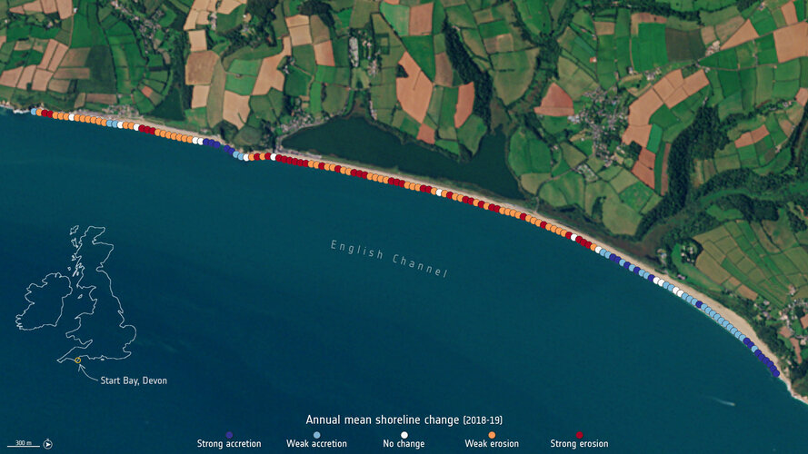
Climate change is having an undeniable influence on coastal areas. A substantial proportion of the world’s sandy coastlines are already eroding owing to increased storm surges, flooding and sea level rise. With our coastal environments in constant change, Earth observation satellites are being used to better strengthen our knowledge of changing coastlines.
Již zítra začíná série webových seminářů
29.3.2021 8:55 ARCDATADovolujeme si vás pozvat na první z šestice webových seminářů, jejichž prostřednictvím vám v průběhu letošního jara přiblížíme svět ArcGIS Pro.
Tento seminář, který se bude věnovat přechodu z ArcMap do prostředí ArcGIS Pro, se uskuteční v úterý 30. března 2021 od 10.00 do 10.45. Další témata a jejich termíny naleznete v přehledu všech webových seminářů.
Pro sledování není zapotřebí instalovat žádný software, ani doplněk prohlížeče, stačí se pouze zaregistrovat na stránce webináře.Registrace i účast na semináři jsou zdarma, avšak registrace je nutná pro každý webový seminář zvlášť.
Výběrové řízení
29.3.2021 7:31 ČÚZK - předpisy a opatření Katastrální úřad pro Plzeňský kraj - Katastrální pracoviště Plzeň-město zveřejnil novou aktualitu: Ředitelka Katastrálního úřadu pro Plzeňský kraj vyhlašuje výběrové řízení na služební místo odborný referent/vrchní referent – zápisy v řízení V a Z ZRVZ1001, oddělení právních vztahů k nemovitostem, Katastrální úřad pro Plzeňský kraj, Katastrální pracoviště Plzeň-město, v oboru služby 55. Zeměměřictví a katastr nemovitostí.Odborný referent/vrchní referent – zápisy v řízení V a Z ZRVZ1001
29.3.2021 7:27 ČÚZK /Urady/Katastralni-urady/Katastralni-urady/Katastralni-urad-pro-Plzensky-kraj/Uredni-deska/Oznameni-a-jina-uredni-sdeleni/Volna-mista/DMS/Odborny-referent-vrchni-referent-–-zapisy-v-rizeniOdborný referent/vrchní referent – zápisy v řízení V a Z ZRVZ1001
29.3.2021 7:27 ČÚZK - předpisy a opatření Katastrální úřad pro Plzeňský kraj Katastrální pracoviště Plzeň-městovypisuje výběrové řízení na místo
Odborný referent/vrchní referent – zápisy v řízení V a Z ZRVZ1001
Odborný referent/vrchní referent – zápisy v řízení V a Z ZRVZ1001
29.3.2021 7:27 ČÚZK - volná místa Katastrální úřad pro Plzeňský kraj Katastrální pracoviště Plzeň-město vypisuje výběrové řízení na místo Odborný referent/vrchní referent – zápisy v řízení V a Z ZRVZ1001Převodník Konfigurátoru korpusů od firmy BLUM do DAEX DESIGN
27.3.2021 21:38 ŠPINAR - softwareVážení zákazníci,
nový převodník Konfigurátoru korpusů od firmy Blum do DAEX DESIGN Vám ulehčí Vaší práci.
The post Převodník Konfigurátoru korpusů od firmy BLUM do DAEX DESIGN appeared first on ŠPINAR – software.
Chráněno: Převodník Konfigurátoru korpusů od firmy Blum do DAEX DESIGN
27.3.2021 21:38 ŠPINAR - softwareStručný obsah příspěvku zde není uveden, protože je tento příspěvek chráněn heslem.
The post Chráněno: Převodník Konfigurátoru korpusů od firmy Blum do DAEX DESIGN appeared first on ŠPINAR – software.
Převodník Konfigurátoru korpusů od firmy Blum do DAEX DESIGN
27.3.2021 21:38 ŠPINAR - softwareVážení zákazníci,
nový převodník Konfigurátoru korpusů od firmy Blum do DAEX DESIGN Vám ulehčí Vaší práci.
The post Převodník Konfigurátoru korpusů od firmy Blum do DAEX DESIGN appeared first on ŠPINAR – software.
Převodník Konfigurátoru korpusů od firmy BLUM do DAEX DESIGN
27.3.2021 21:38 ŠPINAR - software Vážení zákazníci,nový převodník Konfigurátoru korpusů od firmy Blum do DAEX DESIGN Vám ulehčí Vaší práci.
WIMI and other Tech Giants Are into the Battlefield while Lidar accelerating the Commercialization of Autonomous Driving while
26.3.2021 18:37 GISCafe.com Webcasts-Webinars HONG KONG, March 26, 2021 (GLOBE NEWSWIRE) -- Tailor Insight, the fintech market research organization, recently released a research report "WIMI …SUEZ CANAL, EGYPT: Satellite Images Show Stuck Container Ship
26.3.2021 16:40 GISCafe.com Webcasts-Webinars Munich, 26/03/21At 400 m long and 59 m wide, a 200,000 tonne container ship has been blocking the passage of other vessels in both directions …
Trimble Named GNSS Positioning Technology Supplier for VSI Labs Autonomous Vehicle Research Program
26.3.2021 16:19 GISCafe.com Webcasts-Webinars On the Road Providing Reliable In-Lane Positioning for the Year-Long Research ProgramSUNNYVALE, Calif., March 26, 2021 — (PRNewswire) — …
Esri State and Local Government Users Honored by US EAC
26.3.2021 16:19 GISCafe.com Webcasts-Webinars Jurisdictions Used GIS to Ensure Safe, Reliable, and Efficient Elections during PandemicREDLANDS, Calif. — (BUSINESS WIRE) — March 26, …
Suez Canal traffic jam seen from space
26.3.2021 14:58 ESA Observing the Earth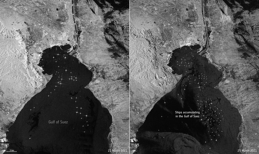 Image:
The enormous Ever Given container ship, wedged in Egypt’s Suez Canal, is visible in new images captured by the Copernicus Sentinel-1 mission.
Image:
The enormous Ever Given container ship, wedged in Egypt’s Suez Canal, is visible in new images captured by the Copernicus Sentinel-1 mission.
ESA–EGU announce Excellence Award winners
26.3.2021 13:30 ESA Observing the Earth
ESA, along with the European Geosciences Union (EGU), are excited to announce the winners of the first ESA–EGU Earth Observation Excellence Awards.
Zveřejnění obsahu informací poskytnutých na žádost dle zákona č. 106/1999 Sb. za rok 2021
26.3.2021 12:57 ČÚZK /Urady/Zememericke-a-katastralni-inspektoraty/Zememericke-a-katastralni-inspektoraty/Zememericky-a-katastralni-inspektorat-v-Praze/Casto-hledane-informace/Poskytovani-informaci-106-1999-Sb/Zverejneni-obsahu-informaci-poskytnutych-na-za-(1)/Zverejneni-obsahu-informaci-poskytnutych-na-za-(3)Zveřejnění obsahu informací poskytnutých na žádost dle zákona č. 106/1999 Sb. za rok 2021
26.3.2021 12:57 ČÚZK - předpisy a opatření Zeměměřický a katastrální inspektorát v Prazezveřejňuje obsah informace poskytnutých na žádost dle zákona č. 106/1999 Sb. za rok
2021
20210326_úprava
26.3.2021 12:50 ČÚZK - předpisy a opatření Katastrální úřad pro Středočeský kraj - Katastrální pracoviště Kladno zveřejnil novou aktualitu: Úprava úředních hodinDnem 29. 3. 2021 budou na KP Kladno rozšířeny úřední hodiny pro poskytování údajů z KN na pondělí a středu od 8:00 – 17:00, podatelna bude nadále otevřena v pondělí a středu od 8:00 – 17:00. Po dobu pokračující pandemie onemocnění COVID-19 zůstává možnost bezkontaktního podání do sběrného boxu v každý pracovní den od 7:00 – 17:00: veškerá podání, včetně žádostí o poskytnutí údajů z KN, je možné vhodit v zalepené obálce do uzavřeného sběrného boxu, který je pro KP Kladno zpřístupněn v hale u vchodu do budovy KP Kladno. Pokud bude v podání uvedena e-mailová adresa, bude na ní zasláno potvrzení o přijetí podání. Za okamžik podání návrhu na vklad se považuje okamžik výběru sběrného boxu. V případě, že je s podáním spojena poplatková povinnost, bude účastníkům zaslána i výzva k úhradě správního poplatku převodem na účet. Děkujeme, že budete v co největší míře využívat této zcela bezkontaktní možnosti podání vůči katastrálnímu úřadu.
20210326_úprava
26.3.2021 12:50 ČÚZK /Urady/Katastralni-urady/Katastralni-urady/Katastralni-urad-pro-Stredocesky-kraj/Katastralni-pracoviste/KP-Kladno/O-uradu/Aktuality/20210326_upravaZveřejnění obsahu informací poskytnutých na žádost dle zákona č. 106/1999 Sb. za rok 2021
26.3.2021 10:43 ČÚZK - předpisy a opatření Katastrální úřad pro Karlovarský krajzveřejňuje obsah informace poskytnutých na žádost dle zákona č. 106/1999 Sb. za rok
2021
Zveřejnění obsahu informací poskytnutých na žádost dle zákona č. 106/1999 Sb. za rok 2021
26.3.2021 10:43 ČÚZK /Urady/Katastralni-urady/Katastralni-urady/Katastralni-urad-pro-Karlovarsky-kraj/Casto-hledane-informace/Poskytovani-informaci-106-1999-Sb/Zverejneni-obsahu-informaci-poskytnutych-na-za-(1)/Zverejneni-obsahu-informaci-poskytnutych-na-za-(3)Rozpočet úřadu za rok 2021
26.3.2021 10:41 ČÚZK - předpisy a opatření Katastrální úřad pro Karlovarský krajvystavuje rozpočet úřadu za rok
2021
Rozpočet úřadu za rok 2021
26.3.2021 10:41 ČÚZK /Urady/Katastralni-urady/Katastralni-urady/Katastralni-urad-pro-Karlovarsky-kraj/Rozpocet/Rozpocet-uradu-za-rok-2021Want to work with us? we are looking for experts
26.3.2021 10:12 European GNSS Agency
The European GNSS Agency (GSA) is looking for experts to support the Agency with advice on, among others, assessing applications for EU funding, including tenders, grants and prizes, and monitoring of EU-funded projects and contracts. For more information and to download the call click here.
In this call, the GSA is looking for people with a high level of expertise and professional experience in aerospace technologies and engineering, in addition to space applications in transport, agriculture and food, environment and climate change and energy. Other areas of interest include information society, innovation and growth in space applications, safety and security, economic analysis and entrepreneurship, communication and marketing, quality, product and security assurance, configuration management and law.
Submit your application
The call is aimed at individuals who are citizens of an EU Member State, Switzerland or Norway. Legal entities are not normally eligible to apply. Interested parties are invited to submit an expression of interest to callforexperts@gsa.europa.eu, please refer to the call for proposal for the documents to be submitted.
Based on the received expressions of interest, the GSA will draw up a list of interested experts. As and when needed, the GSA will consult the list and assign a contract to the most appropriate expert for the task to be performed.
Tasks may be carried out at the GSA's premises or, at the GSA’s request, remotely using electronic communication tools. They also may need to be performed at other sites, to be specified in the contracts.
The list resulting from this call will be valid for five years from the publication of the call in the GSA webpage. Interested parties may submit an expression of interest at any time prior to the last three months of validity of the list,. For more information, click here.
Media note: This feature can be republished without charge provided the European GNSS Agency (GSA) is acknowledged as the source at the top or the bottom of the story. You must request permission before you use any of the photographs on the site. If you republish, we would be grateful if you could link back to the GSA website (http://www.gsa.europa.eu).
Want to work with us? we are looking for experts
26.3.2021 10:12 European GNSS AgencyThe European GNSS Agency (GSA) is looking for experts to support the Agency with advice on, among others, assessing applications for EU funding, including tenders, grants and prizes, and monitoring of EU-funded projects and contracts. For more information and to download the call click here.
In this call, the GSA is looking for people with a high level of expertise and professional experience in aerospace technologies and engineering, in addition to space applications in transport, agriculture and food, environment and climate change and energy. Other areas of interest include information society, innovation and growth in space applications, safety and security, economic analysis and entrepreneurship, communication and marketing, quality, product and security assurance, configuration management and law.
Submit your application
The call is aimed at individuals who are citizens of an EU Member State, Switzerland or Norway. Legal entities are not normally eligible to apply. Interested parties are invited to submit an expression of interest to: callforexperts@gsa.europa.eu ; please refer to the call for proposal for the documents to be submitted.
Based on the received expressions of interest, the GSA will draw up a list of interested experts. As and when needed, the GSA will consult the list and assign a contract to the most appropriate expert for the task to be performed.
Tasks may be carried out at the GSA's premises or, at the GSA’s request, remotely using electronic communication tools. They also may need to be performed at other sites, to be specified in the contracts.
The list resulting from this call will be valid for five years from the publication of the call in the GSA webpage. Interested parties may submit an expression of interest at any time prior to the last three months of validity of the list,. For more information, click here.
Media note: This feature can be republished without charge provided the European GNSS Agency (GSA) is acknowledged as the source at the top or the bottom of the story. You must request permission before you use any of the photographs on the site. If you republish, we would be grateful if you could link back to the GSA website (http://www.gsa.europa.eu).
Earth from Space: Gariep Dam, South Africa
26.3.2021 10:00 ESA Observing the Earth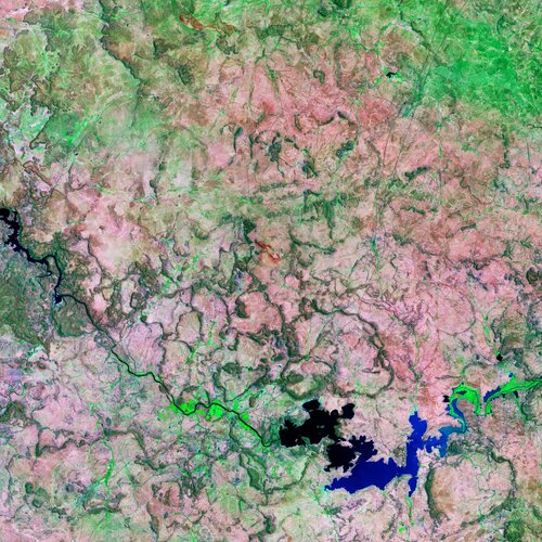
The Gariep Dam, the largest dam in South Africa, is featured in this false-colour image captured by the Copernicus Sentinel-2 mission.
Earth from Space: Gariep Dam, South Africa
26.3.2021 10:00 ESA Observing the Earth
The Gariep Dam, the largest dam in South Africa, is featured in this false-colour image captured by the Copernicus Sentinel-2 mission.
3 Position Announcements ::: Geo-social Analytics Lab.
26.3.2021 9:40 The Interfaculty Department of Geoinformatics – Z_GIS at the University of Salzburg aims to combine high quality education with excellent research. The Faculty has several research groups with an outstanding international reputation and offers three scientific researcher positions within the research group “Geo-Social Analytics Lab”. (https://geosocial.zgis.at) Position Profile: Collaboration in international research projects Analysis of […]Open Position OSM Routing Services Developer, Heidelberg Institute for Geoinformation Technology
26.3.2021 9:37 You genuinely enjoy developing open source Geoinformation Services used by thousands on a daily basis? You are a highly motivated Java Backend Developer and algorithm designer? And you love using and enhancing OpenStreetMap for high-performance GI services for global coverage? Then we actually might have a suitable and interesting job for you. Software Engineer OSM Routing […]Správce GIS
26.3.2021 9:36 Obracíme se na Vás s dotazem, zda byste nevěděli nebo neměli informace o zájemci o práci správce GIS. Musíme upozornit, že se nejedná o práci v ESRI prostředí, ale na pasportech pro město od dodavatele software firmy CDSw –City Data Software, spol. s r. o. https://www.cdsw.cz Pracovní pozice: správce GIS Den nástupu: […]Esri Developer Summit
26.3.2021 9:00 ARCDATAVe dnech 6. až 8. dubna se koná virtuální Esri Developer Summit – konference zaměřená na technickou stránku technologií ArcGIS. Nemusíte být nutně vývojářem, abyste na ní našli přednášky a workshopy, které vám pomohou při práci. Mnoho přednášek se sice zaměřuje na ArcGIS API for Python, JavaScript a na různá SDK, další workshopy se ale věnují například jazyku Arcade, ArcGIS Field Maps, strojovému učení, správě ArcGIS Enterprise a mnoha dalším tématům, která se technologiemi zabývají detailně.
Registrační poplatek se slevou do 2. dubna činí 45 USD a obsahuje přístup na hlavní přednášky a workshopy, na technické přednášky i do prostředí „Ask our experts“, kde je možné klást dotazy prostřednictvím chatu.
Více informací naleznete na následujících odkazech:

GfK releases RegioGraph 2021
26.3.2021 8:00 GISCafe.com Webcasts-Webinars Geomarketing software offers numerous innovations for its 30th anniversaryBruchsal, Germany, March 22, 2021 – The latest version of …
Mason, Bruce & Girard, Inc. Launches New Offering: MB&G Inventory Management System Hosted
26.3.2021 8:00 GISCafe.com Webcasts-Webinars Mason, Bruce & Girard, Inc. (MB&G) is dedicated to offering innovative data collection, management and analysis solutions to their natural …Innoviz Launches Revolutionary Automotive Perception Platform to Accelerate Major Automakers' Autonomous Vehicle Production
26.3.2021 0:07 GISCafe.com Webcasts-Webinars Innoviz now ships its Automotive Perception Platform, InnovizAPP, to key automotive customers globally for evaluation, expanding access to critical …Strojírenský veletrh v Hannove
26.3.2021 0:00 SolidVision Strojírenský veletrh v Hannoveru digitálně – máme pro vás vstupenky zdarma!Strojírenský veletrh v Hannove
26.3.2021 0:00 SolidVision Strojírenský veletrh v Hannoveru digitálně – máme pro vás vstupenky zdarma!Lidar + AI vision - WIMI Hologram Cloud, Apple and Sony's Ambition in Unmanned Driving Solutions
25.3.2021 18:17 GISCafe.com Webcasts-Webinars HONG KONG, March 25, 2021 (GLOBE NEWSWIRE) -- MobiusTrend, the fintech market research organization, recently released a research report "Lidar + AI …Draper Hero Institute Launches New Innovation Research Index
25.3.2021 18:16 GISCafe.com Webcasts-Webinars Data includes indicators on the state of entrepreneurial activity, environment and drivers - nationally and globallySAN MATEO, Calif., March 25, …
TomTom’s Cloud-Native In-Dash Navigation has Arrived
25.3.2021 16:22 GISCafe.com Webcasts-Webinars TomTom Navigation for Automotive is the most comprehensive navigation solution for automakers available todayThe new generation is cloud-native and …Trimble Announces New GNSS Timing Module--Delivering Superior Standard for 5G Network Synchronization
25.3.2021 16:22 GISCafe.com Webcasts-Webinars Dual-Frequency Timing Module Provides Anti-Jamming and Anti-Spoofing CapabilitiesSUNNYVALE, Calif., March 25, 2021 — (PRNewswire) — …
BlackSky’s Newest Satellite Delivers First Insights Within 24 Hours
25.3.2021 16:22 GISCafe.com Webcasts-Webinars Successful Launch of BlackSky’s Newest Satellite Advances the Company’s Dawn-to-Dusk Global Monitoring and High-Revisit CapabilitiesHERNDON, Va. …
BlackSky Accelerates Constellation Deployment with Five Rocket Lab Launches
25.3.2021 16:22 GISCafe.com Webcasts-Webinars Company’s real-time geospatial solutions to average one-hour dawn-to-dusk imaging revisit rates and 90-minute delivery timesHERNDON, Va. — …
Kongsberg Geospatial and Sentient Vision Systems partner to integrate Artificial Intelligence sensor analysis capabilities for UAS operators
25.3.2021 16:22 GISCafe.com Webcasts-Webinars Integrating autonomous detection for EO and IR video into Kongsberg Geospatial MIDAS will enhance ISR operator mission successOTTAWA, Ontario, March …
Intermap Powers Global Airport Infrastructure
25.3.2021 16:21 GISCafe.com Webcasts-Webinars DENVER, March 25, 2021 — (PRNewswire) — Intermap Technologies (TSX: IMP) (OTCQX: ITMSF) ("Intermap" or the "Company"), a global …Zpracování družicových dat v cloudu [Katedra aplikované geoinformatiky a kartografie, byTopic]
25.3.2021 9:05 Katedra aplikované geoinformatiky a kartografie Přf UK Pozvánka na dva online semináře, v rámci kterých budou představeny volně dostupné zdroje družicových snímků, nástroje na zobrazení a zpracování družicových dat v cloudových aplikacích Sentinel Hub (30.3.2021) a Google Earth Engine (6.4.2021).Jak využít koncept mapových kompozic ve vzdělávání (webinář)
25.3.2021 8:33 GISportal.cz
Dvanáctý webinář Otevřeného jara se bude konat 30. března od 13:00 a představí otevřené, především webové technologie, které umožní interaktivní a atraktivní zařazení map do výuky. Postupně budou prezentovány ukázky tvorby jednoduchých map, jejich publikace na webu a především propojení s existujícími daty a mapami do rozsáhlejších mapových kompozic. Lektoři vás postupně seznámí s […]
The post Jak využít koncept mapových kompozic ve vzdělávání (webinář) appeared first on GISportal.cz.
Komise pro SDZ a obhajobu tezí ve čtvrtek 25. 3. 2021
25.3.2021 0:00 Geografický ústav MU
Obhajoby tezí jsou veřejné. Jsou vytvořeny tři skupiny, pro připojení do nich je možno použít následující odkazy:
čtvrtek dopoledne (Ugwitz, Pavelka) - od 9:00
Jak na plagiátorství: příručky pro studenty a akademické pracovníky [Knihovna geografie, byTopic]
25.3.2021 0:00 Katedra aplikované geoinformatiky a kartografie Přf UK V roce 2020 se devět českých a moravských univerzit spojilo v projektu Posílení prevence plagiátorství ve studentských pracích, jehož cílem je zahájení intenzivní debaty a praktické spolupráce v oblasti podpory akademické etiky a prevence podvodných praktik v akademickém psaní. Výsledkem jsou dvě volně přístupné příručky (pro studenty a akademické pracovníky), které za podpory Ministerstva školství, mládeže a tělovýchovy ČR vydalo nakladatelství Karolinum (odkaz níže).Utilis secures $6m from Beringea to harness satellites to protect critical infrastructure and global water supplies
24.3.2021 23:24 GISCafe.com Webcasts-Webinars Analytics first developed for detecting water on Mars can spot leaks up to 3m undergroundSAN DIEGO, March 24, 2021 — (PRNewswire) — …
CIT GAP Funds Invests in Linebird to Bring the Unmanned Systems Revolution to High Voltage Power Lines
24.3.2021 17:32 GISCafe.com Webcasts-Webinars Richmond, VA, March 24, 2021 (GLOBE NEWSWIRE) -- The Center for Innovative Technology (CIT) today announced that CIT GAP Funds has invested in …Woolpert Announces Strategic Investment by MSD Partners
24.3.2021 17:32 GISCafe.com Webcasts-Webinars DAYTON, Ohio, March 24, 2021 — (PRNewswire) — Woolpert, a premier geospatial, architecture, engineering and services …Blickfeld LiDAR Technology Detects Passenger Flows at Frankfurt Airport
24.3.2021 16:09 GISCafe.com Webcasts-Webinars 3D data optimize passenger logistics and enable the prediction of passenger trafficMUNICH & FRANKFURT, Germany — (BUSINESS WIRE) — …
Bentley Systems Issues Call for Nominations for the 2021 Going Digital Awards in Infrastructure
24.3.2021 16:09 GISCafe.com Webcasts-Webinars Winners to be Announced at the Year in Infrastructure 2021 ConferenceEXTON, Pa. — (BUSINESS WIRE) — March 24, 2021 —
Bentley …
Murata’s LiDAR Based System Provides Data to Traffic Monitoring Service
24.3.2021 16:09 GISCafe.com Webcasts-Webinars KYOTO, Japan — (BUSINESS WIRE) — March 23, 2021 —In April, Murata Manufacturing Co., Ltd. (TOKYO:6981) (ISIN:JP3914400001) will …
Unity and HERE Collaborate On Real-Time 3D In-Vehicle Experiences
24.3.2021 16:09 GISCafe.com Webcasts-Webinars Unity and HERE to showcase their innovative vision for the next phase of embedded, automotive human-machine interface (HMI) user-experiences …Lifesaving NEC drone technology quickly locates missing natural disaster victims by mobile phone
24.3.2021 16:09 GISCafe.com Webcasts-Webinars HEIDELBERG, Germany, March 24, 2021 — (PRNewswire) — NEC Laboratories Europe has prototyped new, AI-enabled drone technology that …HRDLIČKA Holding se rozrůstá o další společnost
24.3.2021 15:40 Hrdlička Nová společnost nese název GEODATA UkraineWater mission takes on space weather
24.3.2021 15:20 ESA Observing the Earth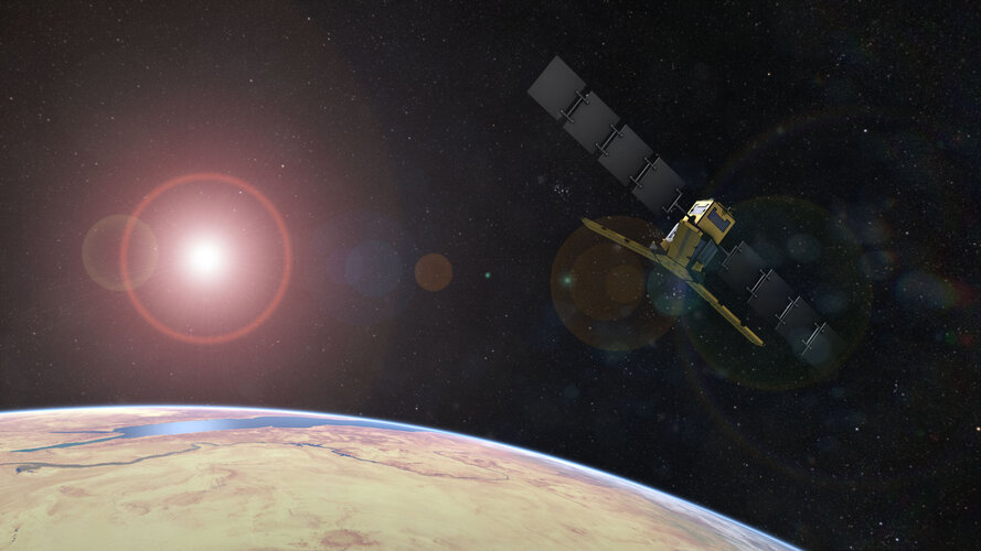
For well over a decade, ESA’s SMOS satellite has been delivering a wealth of data to map moisture in soil and salt in the surface waters of the oceans for a better understanding of the processes driving the water cycle. While addressing key scientific questions, this exceptional Earth Explorer has repeatedly surpassed expectations by returning a wide range of unexpected results, often leading to practical applications that improve everyday life. Adding to SMOS’ list of talents, new findings show that what was considered noise in the mission’s data can actually be used to monitor solar activity and space weather, which can damage communication and navigation systems.
VO - Obnova LAN infraštruktúry
24.3.2021 14:15
ÚGKK SR
Ako riadny hospodári s verejným majetkom dávame transparentne verejne na známosť Oznámenie o verejnom obstarávaní na časť komunikačnej infraštruktúru v našom rezorte ÚGKK SR. Jedná sa o časť LAN a časť WIFI zariadení v predpokladanej hodnote zákazy do 170tis € a termín predkladania ponúk je do 23.04.2021 10:30h. Budeme radi ak sa prihlási čo najviac záujemcov, aby sa nám vygenerovala čo najlepšia kvalita za čo najlepšiu cenu.
Podrobnosti sú na tomto linku https://eo.eks.sk/ElektronickaTabula/Detail/1946
VO - Obnova LAN infraštruktúry
24.3.2021 14:15
ÚGKK SR
Ako riadny hospodári s verejným majetkom dávame transparentne verejne na známosť Oznámenie o verejnom obstarávaní na časť komunikačnej infraštruktúru v našom rezorte ÚGKK SR. Jedná sa o časť LAN a časť WIFI zariadení v predpokladanej hodnote zákazy do 170tis € a termín predkladania ponúk je do 23.04.2021 10:00h. Budeme radi ak sa prihlási čo najviac záujemcov, aby sa nám vygenerovala čo najlepšia kvalita za čo najlepšiu cenu.
Podrobnosti sú na tomto linku https://eo.eks.sk/ElektronickaTabula/Detail/1946
MyGalileoSolution & MyGalileoDrone: A word from the winners
24.3.2021 13:02 European GNSS Agency
The winners of the MyGalileoSolution & MyGalileoDrone were announced at Entrepreneurship Day, organised by the GSA in March 2021 to promote EGNSS-based creativity and business opportunities. The goal was also to raise awareness of the role of downstream space in achieving the EU’s common goals. The winners spoke about their experience during the competition and how it was helping to take their ideas to the next level.
During the press conference of the Entrepreneurship Day, the GSA Executive Director Rodrigo da Costa said that the winning teams had shown particular excellence in terms of innovation, use of Galileo, and market potential. “The downstream space market is expected to grow by over 70% in the next 10 years. This means reaching a value of 65 billion euros by the end of the decade,” da Costa stated, adding that one of the main goals of the MyGalileo competitions was to tap into this market potential.
Christoph Kautz, Acting Head of Unit for Development and Applications from the European Commission Directorate-General for Defence Industry and Space noted the need for a strong dynamic and globally competitive EU space industry both upstream and downstream. “The future of the European space industry is a combination of strong institutional leadership and an industrial New Space” he said.
Galileo: faster, safer, greener
Giuseppe Tortora from the team Abzero (Italy), winner of first prize in the MyGalileoDrone competition for Nautilus, a unique tracking solution for the autonomous delivery of medical goods, highlighted the importance of a civil satellite navigation constellation. “This means we can rely on the system all the time. Galileo helps make our system simpler, faster, safer and greener,” he said, adding that the Nautilus solution needed a GNSS that could interact with its Artificial Intelligence to offer a reliable and safe system to guarantee on-time delivery.
Read this: MGS & MDG: Galileo means business for SMEs and start-ups!
“The MyGalileoDrone competition is a push for us to continue our business and grow into a European start-up that can compete on the market,” Tortora said. His teammate Andrea Cannas said that the competition offered mentoring support during the development and a concrete funding opportunity, which is very important to further develop the product and service. “This provides us the opportunity to scale-up and achieve higher accuracy and a safer performance of our solution,” he said.
Bringing space solutions to customers
“Winning this competition is our biggest achievement so far,” said Matija Jasarov from VisionAnchor (Slovenia). VisionAnchor won the first prize in Track 1 (from idea to prototype) of the MyGalileoSolution competition and is the world's first video anchor monitoring system for boats.
“We saw a multi-million-euro niche for our solution, which allows you to know what is happening underwater at all times and makes it possible to protect underwater vegetation, so it is good both for boat owners and for the environment,” he said. Jasarov said that the GSA support provided through the MyGalileoSolution competition would help get the solution to its first customers because we now have a prototype.
Winner of first prize in Track 2 of MyGalileoSolution (from prototype to product) was 10Lines (Estonia), an autonomous parking lot marking solution. Highlighting the environmental benefits of the solution, team member Janno Paas said that the 10Lines solution is stripe parking lots 7 times faster with robots. This is allowing to save CO2. “GNSS positioning is a very important element of our solution,” he said.
And this: Galileo enabling infrastructure development in harsh environments
Paas noted in particular the value of the mentoring support received during the competition. “We received a lot of help from the MyGalileoSolution team and have enhanced our standards and the reliability of our solution, as a result. “The success validates what we do. We hope to be out there and visible soon,” said his teammate Tarmo Prints.
What’s next?
Speaking at the conference, Kautz presented the Cassini initiative actions to support young entrepreneurs. He mentioned the Cassini business accelerator, which would help start-ups to develop a business plan and get start-up funding. “We want to give start-ups access to the sharpest business accelerators in the EU,” he added.
The GSA Executive Director stressed that the winners had demonstrated why these competitions are important. “They give the push to take ideas to the next level. We will continue to accompany all the companies that have applied to the competition, they will continue to be visible on our website, we will also open up new opportunities in the future,” he said. Da Costa added that, with the inclusion of the commercial utilization of Copernicus under the umbrella of the European Union Space Programme Agency (EUSPA), future opportunities would also target synergies between the various elements of the space programme.
Media note: This feature can be republished without charge provided the European GNSS Agency (GSA) is acknowledged as the source at the top or the bottom of the story. You must request permission before you use any of the photographs on the site. If you republish, we would be grateful if you could link back to the GSA website (http://www.gsa.europa.eu).
MyGalileoSolution & MyGalileoDrone: A word from the winners
24.3.2021 13:02 European GNSS AgencyThe winners of the MyGalileoSolution & MyGalileoDrone were announced at Entrepreneurship Day, organised by the GSA in March 2021 to promote EGNSS-based creativity and business opportunities. The goal was also to raise awareness of the role of downstream space in achieving the EU’s common goals. The winners spoke about their experience during the competition and how it was helping to take their ideas to the next level.
During the press conference of the Entrepreneurship Day, the GSA Executive Director Rodrigo da Costa said that the winning teams had shown particular excellence in terms of innovation, use of Galileo, and market potential. “The downstream space market is expected to grow by over 70% in the next 10 years. This means reaching a value of 65 billion euros by the end of the decade,” da Costa stated, adding that one of the main goals of the MyGalileo competitions was to tap into this market potential.
Christoph Kautz, Acting Head of Unit for Development and Applications from the European Commission Directorate-General for Defence Industry and Space noted the need for a strong dynamic and globally competitive EU space industry both upstream and downstream. “The future of the European space industry is a combination of strong institutional leadership and an industrial New Space” he said.
Galileo: faster, safer, greener
Giuseppe Tortora from the team Abzero (Italy), winner of first prize in the MyGalileoDrone competition for Nautilus, a unique tracking solution for the autonomous delivery of medical goods, highlighted the importance of a civil satellite navigation constellation. “This means we can rely on the system all the time. Galileo helps make our system simpler, faster, safer and greener,” he said, adding that the Nautilus solution needed a GNSS that could interact with its Artificial Intelligence to offer a reliable and safe system to guarantee on-time delivery.
Read this: MGS & MDG: Galileo means business for SMEs and start-ups!
“The MyGalileoDrone competition is a push for us to continue our business and grow into a European start-up that can compete on the market,” Tortora said. His teammate Andrea Cannas said that the competition offered mentoring support during the development and a concrete funding opportunity, which is very important to further develop the product and service. “This provides us the opportunity to scale-up and achieve higher accuracy and a safer performance of our solution,” he said.
Bringing space solutions to customers
“Winning this competition is our biggest achievement so far,” said Matija Jasarov from VisionAnchor (Slovenia). VisionAnchor won the first prize in Track 1 (from idea to prototype) of the MyGalileoSolution competition and is the world's first video anchor monitoring system for boats.
“We saw a multi-million-euro niche for our solution, which allows you to know what is happening underwater at all times and makes it possible to protect underwater vegetation, so it is good both for boat owners and for the environment,” he said. Jasarov said that the GSA support provided through the MyGalileoSolution competition would help get the solution to its first customers because we now have a prototype.
Winner of first prize in Track 2 of MyGalileoSolution (from prototype to product) was 10Lines (Estonia), an autonomous parking lot marking solution. Highlighting the environmental benefits of the solution, team member Janno Paas said that the 10Lines solution is stripe parking lots 7 times faster with robots. This is allowing to save CO2. “GNSS positioning is a very important element of our solution,” he said.
And this: Galileo enabling infrastructure development in harsh environments
Paas noted in particular the value of the mentoring support received during the competition. “We received a lot of help from the MyGalileoSolution team and have enhanced our standards and the reliability of our solution, as a result. “The success validates what we do. We hope to be out there and visible soon,” said his teammate Tarmo Prints.
What’s next?
Speaking at the conference, Kautz presented the Cassini initiative actions to support young entrepreneurs. He mentioned the Cassini business accelerator, which would help start-ups to develop a business plan and get start-up funding. “We want to give start-ups access to the sharpest business accelerators in the EU,” he added.
The GSA Executive Director stressed that the winners had demonstrated why these competitions are important. “They give the push to take ideas to the next level. We will continue to accompany all the companies that have applied to the competition, they will continue to be visible on our website, we will also open up new opportunities in the future,” he said. Da Costa added that, with the inclusion of the commercial utilization of Copernicus under the umbrella of the European Union Space Programme Agency (EUSPA), future opportunities would also target synergies between the various elements of the space programme.
Media note: This feature can be republished without charge provided the European GNSS Agency (GSA) is acknowledged as the source at the top or the bottom of the story. You must request permission before you use any of the photographs on the site. If you republish, we would be grateful if you could link back to the GSA website (http://www.gsa.europa.eu).
Satellites map record floods in Australia
24.3.2021 11:30 ESA Observing the Earth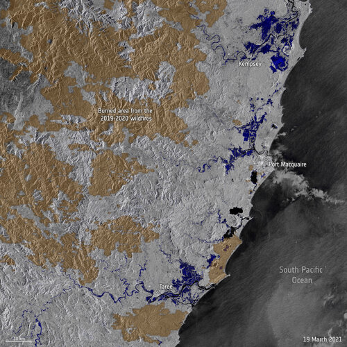 Image:
Stretches of land across New South Wales, Australia, have been hit with torrential rain leading to record-breaking floods. Data from the Copernicus Sentinel-1 mission are being used to map flooded areas to help relief efforts.
Image:
Stretches of land across New South Wales, Australia, have been hit with torrential rain leading to record-breaking floods. Data from the Copernicus Sentinel-1 mission are being used to map flooded areas to help relief efforts.
Nabídka práce: Správce GIS
24.3.2021 9:48 Společnost City Data Software, spol. s r. o. https://www.cdsw.cz Pracovní pozice: správce GIS Den nástupu: 1.5.2021 Druh pracovního poměru: hlavní, doba určitá – 1 rok s možností prodloužení Požadované vzdělání: vysokoškolské Směnnost: jednosměnný, úvazek 37,5 hodin týdně Místo výkonu práce: Ostrava Praxe vítána: minimálně 5 […]20210324_Vrchní referent / rada oddělení aktualizace PI KN II.
24.3.2021 8:23 ČÚZK - předpisy a opatření Katastrální úřad pro Středočeský kraj - Katastrální pracoviště Praha-západ Vyhlášení výběrového řízení: Vrchní referent / rada oddělení aktualizace PI KN II. V části "Úřední deska", v sekci "Oznámení a jiná úřední sdělení" bylo vystaveno "Oznámení o vyhlášení výběrového řízení na obsazení služebního místa Vrchní referent / rada oddělení aktualizace PI KN II."20210324_Vrchní referent / rada oddělení aktualizace PI KN II.
24.3.2021 8:23 ČÚZK /Urady/Katastralni-urady/Katastralni-urady/Katastralni-urad-pro-Stredocesky-kraj/Katastralni-pracoviste/KP-Praha-zapad/O-uradu/Aktuality/20210113_odborny-rada,-reditel-Katastralniho-p-(5)Noční rozdíl teplot mezi městy a jejich okolím je až 7 °C. Přehřívání metropolí může řešit výsadba stromů i zelené budovy (TZ)
24.3.2021 8:08 GISportal.cz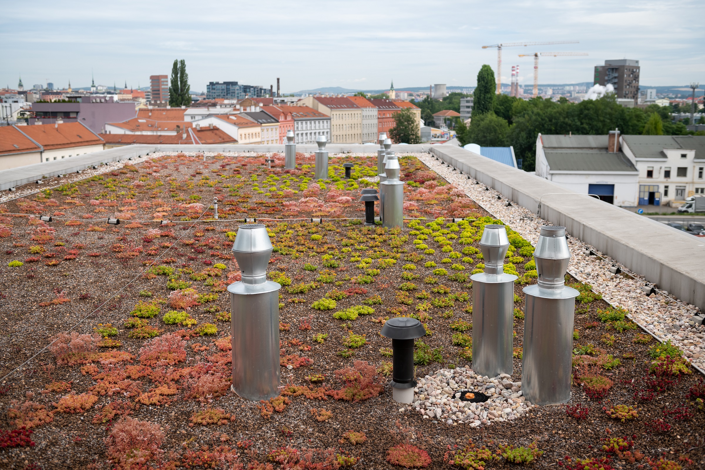
Vydlážděná či vybetonovaná prostranství a minimum zeleně. To je problém, který trápí řadu tuzemských měst. Taková místa totiž akumulují obrovské množství tepla, jež následně vyzařují. Teploty v centrech měst jsou pak oproti okolním lokalitám vyšší, v noci může rozdíl činit až 7 °C. Řešením je výsadba nové zeleně a využívání zelených střech a fasád. V posledních letech se v souvislosti […]
The post Noční rozdíl teplot mezi městy a jejich okolím je až 7 °C. Přehřívání metropolí může řešit výsadba stromů i zelené budovy (TZ) appeared first on GISportal.cz.
Výzva k podání návrhu k nájmu bytu - Rýmařov
24.3.2021 0:00 Státní pozemkový úřad SPÚ vyhlašuje výzvu k podání návrhů na uzavření smlouvy o nájmu bytu - RýmařovVýzva k podání návrhu k nájmu bytu - Rýmařov
24.3.2021 0:00 Státní pozemkový úřad SPÚ vyhlašuje výzvu k podání návrhů na uzavření smlouvy o nájmu bytu - RýmařovOd čtvrtka 1.4.2021 je opět možná výpůjčka knih! [Knihovna geografie, byTopic]
24.3.2021 0:00 Katedra aplikované geoinformatiky a kartografie Přf UK Od příštího týdne je opět zahájen omezený provoz výpůjčních služeb Knihovny geografie. Výpůjčky bude možné si vyzvednout každý čtvrtek od 9 do 11 hodin po předchozí rezervaci pomocí on-line formuláře (odkaz níže) a potvrzení e-mailem ze strany knihovny.Albertovští geoinformatici ovládly studentskou soutěž GISáček [Katedra aplikované geoinformatiky a kartografie, byTopic]
23.3.2021 18:10 Katedra aplikované geoinformatiky a kartografie Přf UK V pátek, 19. března 2021 se konala tradiční studentská soutěž GISáček, letos s mezinárodní účastí. Studenti katedry aplikované geoinformatiky a kartografie sklidili významné úspěchy jak v sekci bakalářských prací, tak i v magisterské sekci.Albertovští geoinformatici ovládli studentskou soutěž GISáček [Katedra aplikované geoinformatiky a kartografie, byTopic]
23.3.2021 18:10 Katedra aplikované geoinformatiky a kartografie Přf UK V pátek, 19. března 2021 se konala tradiční studentská soutěž GISáček, letos s mezinárodní účastí. Studenti katedry aplikované geoinformatiky a kartografie sklidili významné úspěchy jak v sekci bakalářských prací, tak i v magisterské sekci.Bylo vypsáno výběrové řízení na služební místo v odd. právních vztahů
23.3.2021 17:35 ČÚZK /Urady/Katastralni-urady/Katastralni-urady/Katastralni-urad-pro-Jihocesky-kraj/Katastralni-pracoviste/KP-Pisek/O-uradu/Aktuality/Bylo-vypsano-vyberove-rizeni-na-sluzebni-misto-v-oBylo vypsáno výběrové řízení na služební místo v odd. právních vztahů
23.3.2021 17:35 ČÚZK - předpisy a opatření Katastrální úřad pro Jihočeský kraj - Katastrální pracoviště Písek zveřejnil novou aktualitu: Bylo vypsáno výběrové řízení na služební místo rada/odborný rada – rozhodování o povolení vkladu v oddělení právních vztahů k nemovitostem Katastrálního pracoviště PísekFortem Technologies and Toshiba Announce Strategic Alliance
23.3.2021 17:01 GISCafe.com Webcasts-Webinars Pleasant Grove, UT and Kawasaki, March 23, 2021 (GLOBE NEWSWIRE) -- Fortem Technologies, Inc., a leader in airspace security and defense for …MapBusinessOnline Issues USA Map Update of COVID-19 Vaccination Progress
23.3.2021 17:01 GISCafe.com Webcasts-Webinars CORNISH, Maine, March 23, 2021 — (PRNewswire) — SpatialTEQ Inc., publisher of North America's most advanced business mapping software …Esri Joins ERES and K&A to Create Geospatial Real Estate Solution
23.3.2021 17:01 GISCafe.com Webcasts-Webinars Collaboration Will Enable Investors and Regulators to Analyze and Map Market DevelopmentsREDLANDS, Calif. — (BUSINESS WIRE) — March 23, …
Bentley Acceleration Initiatives Launches OpenTower iQ, a Digital Co-Venture with Visual Intelligence and Aeroprotechnik for 5G Towers
23.3.2021 17:01 GISCafe.com Webcasts-Webinars Millimeter-accurate Digital Twin Solution Combines Patented Dual-sensor Drone Technologies and Artificial Intelligence to Help Tower Companies …Draganfly Secures One Million Dollar Flight Services Contract
23.3.2021 17:01 GISCafe.com Webcasts-Webinars Los Angeles, CA., March 23, 2021 (GLOBE NEWSWIRE) -- Draganfly Inc. (OTCQB: DFLYF) (CSE: DFLY) (FSE: 3U8) (“Draganfly” or the “Company”), …Esri Releases New Book for Utilities Getting Started with GIS
23.3.2021 17:01 GISCafe.com Webcasts-Webinars Applying Spatial Analytics to Water and Power ServicesREDLANDS, Calif. — (BUSINESS WIRE) — March 23, 2021 —
Esri, the global …