


zprávy
zdroje zpráv:Rada/odborný rada v oddělení aktualizace GI KN na Katastrálním pracovišti Brno - město
19.6.2020 11:54 ČÚZK /Urady/Katastralni-urady/Katastralni-urady/Katastralni-urad-pro-Jihomoravsky-kraj/Uredni-deska/Oznameni-a-jina-uredni-sdeleni/Volna-mista/DMS/Rada-odborny-rada-v-oddeleni-aktualizace-GI-KN-naRada/odborný rada v oddělení aktualizace GI KN na Katastrálním pracovišti Brno - město
19.6.2020 11:54 ČÚZK - předpisy a opatření Katastrální úřad pro Jihomoravský kraj Katastrální pracoviště Brno-městovypisuje výběrové řízení na místo
Rada/odborný rada v oddělení aktualizace GI KN na Katastrálním pracovišti Brno - město
Rada/odborný rada v oddělení aktualizace GI KN na Katastrálním pracovišti Brno - město
19.6.2020 11:54 ČÚZK - volná místa Katastrální úřad pro Jihomoravský kraj Katastrální pracoviště Brno-město vypisuje výběrové řízení na místo Rada/odborný rada v oddělení aktualizace GI KN na Katastrálním pracovišti Brno - město【SatLab Webinar】 New Features Overview in Satsurv 2.0.3 to 2.0.4
19.6.2020 11:45 Satlab GeosolutionsSatLab Webinar-30th June, 2020 What to expect in this Webinar: 1. Tips for Project Management 2. New Features in Surveying and Staking out Interface 3. Introduction of Different Tilt Survey Modes of SatLab Receivers Presenter: Lukasz Migda Country manager of SatLab Geosolutions in Poland
The post 【SatLab Webinar】 New Features Overview in Satsurv 2.0.3 to 2.0.4 appeared first on Satlab – Global Satellite Positioning Solutions.
【SatLab Webinar】 New Features Overview in Satsurv 2.0.3 to 2.0.4
19.6.2020 11:45 Satlab GeosolutionsSatLab Webinar-30th June, 2020 What to expect in this Webinar: 1. Tips for Project Management 2. New Features in Surveying and Staking out Interface 3. Introduction of Different Tilt Survey Modes of SatLab Receivers Presenter: Lukasz Migda Country manager of SatLab Geosolutions in Poland
The post 【SatLab Webinar】 New Features Overview in Satsurv 2.0.3 to 2.0.4 appeared first on Satlab – Global Satellite Positioning Solutions.
【SatLab Webinar】 New features overview in Satsurv 2.0.3 to 2.0.4
19.6.2020 11:45 Satlab GeosolutionsSatLab Webinar-30th June, 2020 What to expect in this Webinar: 1. Tips for Project Management 2. New Features in Surveying and Staking out Interface 3. Introduction of Different Tilt Survey Modes of SatLab Receivers Presenter: Lukasz Migda Country manager of SatLab Geosolutions in Poland
The post 【SatLab Webinar】 New features overview in Satsurv 2.0.3 to 2.0.4 appeared first on Satlab – Global Satellite Positioning Solutions.
Oddělení hospodářské správy - pracovní poměr - domovník
19.6.2020 11:22 ČÚZK - volná místa Katastrální úřad pro Jihočeský kraj kancelář ředitele vypisuje výběrové řízení na místo Oddělení hospodářské správy - pracovní poměr - domovníkOddělení hospodářské správy - pracovní poměr - domovník
19.6.2020 11:22 ČÚZK - předpisy a opatření Katastrální úřad pro Jihočeský kraj kancelář ředitelevypisuje výběrové řízení na místo
Oddělení hospodářské správy - pracovní poměr - domovník
Oddělení hospodářské správy - pracovní poměr - domovník
19.6.2020 11:22 ČÚZK /Urady/Katastralni-urady/Katastralni-urady/Katastralni-urad-pro-Jihocesky-kraj/Volna-mista/DMS/Oddeleni-hospodarske-spravy-pracovni-pomer-domEarth from Space: Great Rift Valley, Kenya
19.6.2020 10:00 ESA Observing the Earth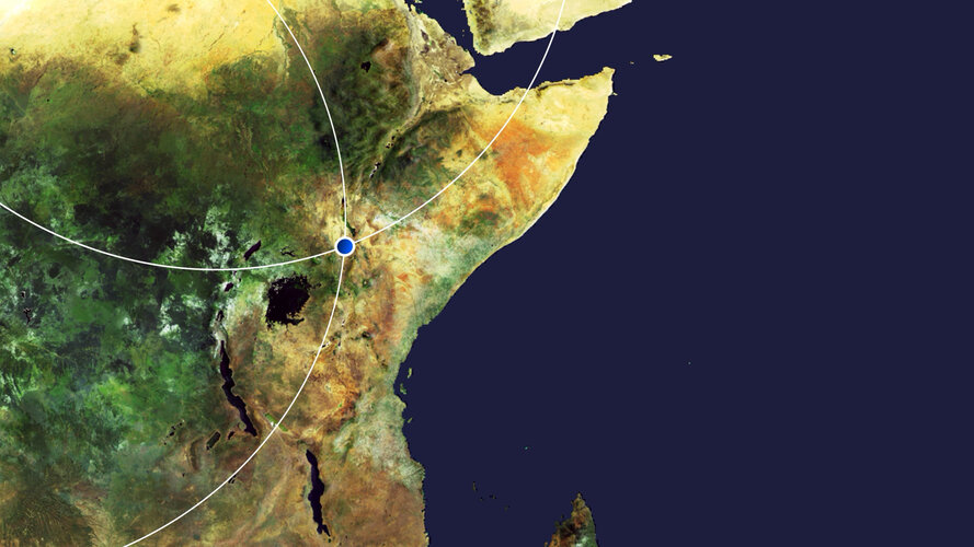 Video:
00:00:00
Video:
00:00:00
In this week's edition of the Earth from Space programme, the Copernicus Sentinel-2 mission takes us over part of the Great Rift Valley, Kenya.
See also Great Rift Valley, Kenya to download the image.
Great Rift Valley, Kenya
19.6.2020 10:00 ESA Observing the Earth Image:
The Copernicus Sentinel-2 mission takes us over part of the Great Rift Valley, Kenya.
Image:
The Copernicus Sentinel-2 mission takes us over part of the Great Rift Valley, Kenya.
Earth from Space: Great Rift Valley, Kenya
19.6.2020 10:00 ESA Observing the Earth Video:
00:00:00
Video:
00:00:00
In this week's edition of the Earth from Space programme, the Copernicus Sentinel-2 mission takes us over part of the Great Rift Valley, Kenya.
See also Great Rift Valley, Kenya to download the image.
Great Rift Valley, Kenya
19.6.2020 10:00 ESA Observing the Earth Image:
The Copernicus Sentinel-2 mission takes us over part of the Great Rift Valley, Kenya.
Image:
The Copernicus Sentinel-2 mission takes us over part of the Great Rift Valley, Kenya.
Travis Bodin, PLS, PMP Named Vice President of Fenstermaker's Survey & Mapping Division
19.6.2020 9:00 GISCafe.com Webcasts-Webinars Lafayette, LA, June 18, 2020 (GLOBE NEWSWIRE) -- C. H. Fenstermaker & Associates, L.L.C. has announced the promotion of Travis Bodin, PLS, PMP …Katastrální mapa ve formátech DGN a DXF poskytovaná v e-shopu
19.6.2020 2:00 Cenia - Katalog metadat ČR - INSPIRE Katastrální mapa je závazným státním mapovým dílem velkého měřítka, obsahuje body polohového bodového pole, polohopis a popis. Katastrální mapa ve vektorové podobě je poskytována zdarma ve formátu DGN a DXF a obsahuje prvky Digitální katastrální mapy (DKM) a Katastrální mapy digitalizované (KMD), tedy bodová pole, budovy, další prvky mapy, hranice parcel, katastrální hranice, parcely katastru nemovitostí, prvky orientační mapy a hranice věcného břemene. Z důvodu použití formátu DGN produkt neobsahuje značky na liniích a oblouky jsou nahrazeny lomenými čárami. Katastrální mapa ve vektorové podobě k 15. 06. 2020 pokrývá 96,81% území České republiky, t.j. 76 347,80km2. Více katastrální vyhláška č.357/2013 Sb. v platném znění.INSPIRE téma Budovy (BU)
19.6.2020 2:00 Cenia - Katalog metadat ČR - INSPIRE Data odpovídají směrnici INSPIRE pro téma budovy (BU). Data pochází částečně z projektu RÚIAN (Registr územní identifikace, adres a nemovitostí), který je součástí základních registrů České Republiky a obsahuje informace o územní identifikaci, adresách a nemovitostech, a částečně z ISKN (Informační systém katastru nemovistostí). Zdrojem informací o budovách v ISKN je objekt Stavba, v RÚIAN je to Stavební objekt. Většina Staveb je zároveň Stavebními objekty, ale jsou případy, kdy tomu tak není. Kromě Budov datová sada obsahuje i části budov, které jsou pro potřeby INSPIRE vyjádřeny vchody z RÚIAN. Vchody obsahují informace o počtu podlaží, technickoekonomických atributech apod. Datová sada pokrývá celé území české republiky. V datové sadě není uvedeno 1,14%, t.j. 48344 budov (k 15. 06. 2020), protože neobsahují definiční bod ani polygon. Více v zákoně č. 111/2009 Sb., o základních registrech, ve vyhlášce č. 359/2011 Sb., o základním registru územní identifikace, adres a nemovitostí v platných zněních, v zákoně 256/2013 Sb., o katastru nemovitostí, v katastrální vyhlášce č. 357/2013 Sb. v platném znění a INSPIRE Data Specification on Buildings v 3.0 z 13.12.2013. Data ve formátu GML 3.2.1 jsou validní proti schématu XML pro INSPIRE téma Budovy ve verzi 4.0 a proti schématu pro prostorová data ELF ve verzi 1.0.INSPIRE téma Adresy (AD)
19.6.2020 2:00 Cenia - Katalog metadat ČR - INSPIRE Data odpovídají směrnici INSPIRE pro téma adresy (AD). Vychází především z projektu RÚIAN (Registr územní identifikace, adres a nemovitostí), který je součástí základních registrů České Republiky a obsahuje informace o územní identifikaci, adresách a nemovitostech. Data publikovaná v rámci INSPIRE obsahují pouze adresní místa a jejich komponenty, kterými jsou stát, obec, část obce, městský obvod v Praze (MOP), městký obvod/městská část (MO/MČ), ulice a pošta a to na území celé České Republiky. Obsahují rozvněž geometrii, která určuje definiční bod adresního místa. V datové sadě nění uvedeno 1,14%, t.j. 33528 adresních míst (k 15. 06. 2020), protože neobsahují definiční bod, podle kterého by je bylo možné prostorově určit. Více v zákoně č. 111/2009 Sb., o základních registrech a ve vyhlášce č. 359/2011 Sb., o základním registru územní identifikace, adres a nemovitostí v platných zněních a INSPIRE Data Specification on Addresses v 3.0.1 z 26.4.2010. Data ve formátu GML 3.2.1 jsou validní proti schématu XML pro INSPIRE téma Adresy ve verzi 4.0 a proti schématu pro prostorová data ELF ve verzi 1.0.INSPIRE téma Rozšířené Parcely (CPX)
19.6.2020 2:00 Cenia - Katalog metadat ČR - INSPIRE Rozšíření má za cíl poskytovat katastrální mapu s obsahem podle vyhlášky ve vektorové podobě ve struktuře plně v souladu se strukturou danou směrnicí INSPIRE. Data rozšiřují směrnici INSPIRE pro téma katastrální parcely (CP) o věcná břemena, geodetické body, další prvky mapy, původní obloukovou geometrii a o parcely určené definičním bodem (ty pouze v oblastech s analogovou mapou). Vychází z katastrální mapy, která je závazným státním mapovým dílem velkého měřítka, obsahuje body polohového bodového pole, polohopis a popis a může mít formu digitální mapy, analogové mapy nebo digitalizované mapy. Publikovaná data obsahují katastrální území pro celou Českou Republiku, parcely a jejich hranice, věcná břemena, další prvky mapy a původní obloukovou geometrii z území, kde je digitální mapa (k 15. 06. 2020 je to 96,81% území České republiky, t.j. 76 347,80km2) a ve zbytku území katastrální parcely určené pouze definičním bodem (tedy bez hranic a polygonu). Katastrální parcely a hranice obsahují oproti datové sadě INSPIRE některé atributy navíc. Jedná se o typ hranice, způsob využití území, druh pozemku, vazbu na budovu a o mapové značky. Více katastrální zákon 344/1992 SB., katastrální vyhláška č.26/2007 Sb. v platném znění a INSPIRE Data Specification on Cadastral Parcels v 3.0.1. Data ve formátu GML 3.2.1 jsou validní proti schématu XML pro Rozšířené Parcely (CPX) ve verzi 4.0.INSPIRE téma Parcely (CP)
19.6.2020 2:00 Cenia - Katalog metadat ČR - INSPIRE Data odpovídají směrnici INSPIRE pro téma katastrální parcely (CP). Vychází z katastrální mapy, která je závazným státním mapovým dílem velkého měřítka, obsahuje body polohového bodového pole, polohopis a popis a může mít formu digitální mapy, analogové mapy nebo digitalizované mapy. Data publikovaná v rámci INSPIRE obsahují pouze katastrální území (pro celou Českou Republiku) a parcely a jejich hranice z území, kde je digitální mapa (k 15. 06. 2020 je to 96,81% území České republiky, t.j. 76 347,80km2). Více katastrální zákon 344/1992 SB., katastrální vyhláška č.26/2007 Sb. v platném znění a INSPIRE Data Specification on Cadastral Parcels v 3.0.1. Data ve formátu GML 3.2.1 jsou validní proti schématu XML pro INSPIRE téma Parcely ve verzi 4.0 a proti schématu pro prostorová data ELF ve verzi 1.0.Saudi Arabia Launches COVID-19 Dashboard Using Esri Technology
19.6.2020 0:52 GISCafe.com Webcasts-Webinars The Country's Ministry of Health Is Tracking Pandemic Cases with New GIS ResourcesREDLANDS, Calif. — (BUSINESS WIRE) — June 18, 2020 …
Před pouhým půl rokem dokončené poldry ochránily Kobeřice před 30letou vodou
19.6.2020 0:00 Státní pozemkový úřad Praha, 19. 6. 2020: Realizaci 1. etapy prioritních společných zařízení vybraných obcí Kobeřice ze schváleného návrhu pozemkových úprav dokončila Pobočka Opava na sklonku loňského roku. Dva vybudované poldry získaly kolaudační rozhodnutí 11. prosince 2019. Aktuální počasí již dokonce prověřilo jejich účinnost a smysluplnost. Podle zástupců obce napadlo 18. 6. 2020 v jejich katastru 49 mm srážek za cca 1 h. Obec na svém facebookovém profilu uvedla, že: „Díky poldrům, které transformovaly cca 30letou vodu, nedošlo k vylití Oldřišovského potoka a větším škodám na majetku."Omezení provozu Pobočky Mladá Boleslav
19.6.2020 0:00 Státní pozemkový úřad Z důvodu havárie na rozvodech vody nebo odpadů v budově Ministerstva zemědělství v Mladé Boleslavi, kde sídlí i naše Pobočka Mladá Boleslav, bude dnes 19. 6. 2020 chod této pobočky omezen. Základní chod pracoviště zajišťuje do 14 hodin vedoucí pobočky, zachován je i chod podatelny. Děkujeme za pochopení.Omezení provozu Pobočky Mladá Boleslav
19.6.2020 0:00 Státní pozemkový úřad Z důvodu havárie na rozvodech vody nebo odpadů v budově Ministerstva zemědělství v Mladé Boleslavi, kde sídlí i naše Pobočka Mladá Boleslav, bude dnes 19. 6. 2020 chod této pobočky omezen. Základní chod pracoviště zajišťuje do 14 hodin vedoucí pobočky, zachován je i chod podatelny. Děkujeme za pochopení.Real-Time, Accurate Corrections for Today’s GIS & Mapping Professionals - Interview with Towfique Ahmed, Product Engineer, Trimble
18.6.2020 21:31 GISCafe.com Webcasts-WebinarsFortem Technologies Brings First-Of-Its-Kind Complete End-to-End Counter Drone Security to Gulf Region
18.6.2020 18:41 GISCafe.com Webcasts-Webinars Pleasant Grove, UT, June 18, 2020 (GLOBE NEWSWIRE) -- Fortem Technologies, the technical leader for counter drone security and defense solutions, …AeroDefense Partners with US Air Force to Develop Ruggedized and Rapid Deploy Drone Detection
18.6.2020 18:41 GISCafe.com Webcasts-Webinars AeroDefense Technology to Detect, Locate, Track Drones and Their Pilots to Protect Mobile Defenders Against Drone-Borne Attacks and Unauthorized …Property Agent Makes $50k in 2 Weeks by Tapping on New Portal’s Geospatial Data and AI Technology
18.6.2020 16:00 GISCafe.com Webcasts-Webinars Singapore, June 17, 2020 (GLOBE NEWSWIRE) -- Marcus Ong of Century 21 Property Agency, joined the Property Concierge (PC) at MOGUL.sg last February …Lytx Launches Solutions for Fleet Tracking, Enabling Real-time, Location-based Video Search
18.6.2020 16:00 GISCafe.com Webcasts-Webinars SAN DIEGO, June 18, 2020 — (PRNewswire) — Lytx®, a leading global provider of machine vision and artificial …Cambridge Semantics Introduces Geospatial Analytics within its Award-Winning AnzoGraph® DB
18.6.2020 16:00 GISCafe.com Webcasts-Webinars AnzoGraph® DB Now Combines Scalable Location Analytics with Relationships and Graph AnalyticsBOSTON, June 18, 2020 — (PRNewswire) — …
Delphi Technologies and TomTom ADAS Map innovation delivers fuel savings of more than 10 percent in passenger cars
18.6.2020 16:00 GISCafe.com Webcasts-Webinars - Combined software package can deliver significant, real-world returns with little-or-no impact on drive times, preferred routes or driving …Změna adresy
18.6.2020 14:56 ČÚZK - předpisy a opatření Katastrální úřad pro Plzeňský kraj - Katastrální pracoviště Kralovice zveřejnil novou aktualitu: Dne 18.6.2020 se KP Kralovice přesunulo na adresu Osvobození 886, Kralovice.Změna adresy
18.6.2020 14:56 ČÚZK /Urady/Katastralni-urady/Katastralni-urady/Katastralni-urad-pro-Plzensky-kraj/O-uradu/Aktuality/Zmena-adresyZměna adresy
18.6.2020 14:56 ČÚZK - předpisy a opatření Katastrální úřad pro Plzeňský kraj - Katastrální pracoviště Kralovice zveřejnil novou aktualitu: Dne 18.6.2020 se KP Kralovice přesunulo na adresu nám. Osvobození 886, Kralovice.Změna adresy
18.6.2020 14:51 ČÚZK /Urady/Katastralni-urady/Katastralni-urady/Katastralni-urad-pro-Plzensky-kraj/Katastralni-pracoviste/KP-Kralovice/O-uradu/Aktuality/Zmena-adresyZměna adresy
18.6.2020 14:51 ČÚZK - předpisy a opatření Katastrální úřad pro Plzeňský kraj zveřejnil novou aktualitu: Dne 18.6.2020 se KP Kralovice přesunulo na adresu nám. Osvobození 886, Kralovice.Změna adresy
18.6.2020 14:51 ČÚZK - předpisy a opatření Katastrální úřad pro Plzeňský kraj zveřejnil novou aktualitu: Dne 18.6.2020 se KP Kralovice přesunulo na adresu Osvobození 886, Kralovice.Call for Media: ESA, NASA and JAXA to unveil COVID-19 Earth Observation Dashboard
18.6.2020 14:50 ESA Observing the EarthPress Release N° 10–2020
ESA, NASA and JAXA invite the general public and media representatives to participate in an online media conference on Thursday, 25 June, at 09:00 EDT (15:00 CEST) where they will present a new dashboard that uses Earth observation data to show the impacts of COVID-19. This new platform will combine data, technical knowledge and expertise of the three space agencies to strengthen our global understanding of the environmental and economic impacts of the COVID-19 pandemic.
Call for Media: ESA, NASA and JAXA to unveil COVID-19 Earth Observation Dashboard
18.6.2020 14:50 ESA Observing the EarthPress Release N° 10–2020
ESA, NASA and JAXA invite the general public and media representatives to participate in an online media conference on Thursday, 25 June, at 09:00 EDT (15:00 CEST) where they will present a new dashboard that uses Earth observation data to show the impacts of COVID-19. This new platform will combine data, technical knowledge and expertise of the three space agencies to strengthen our global understanding of the environmental and economic impacts of the COVID-19 pandemic.
Listiny do Sbírky listin
18.6.2020 11:04 ČÚZK - předpisy a opatření Katastrální úřad pro Jihočeský kraj - Katastrální pracoviště Strakonicezveřejnil novou aktualitu: Listiny, které ukládáme do Sbírky listin, nám prosím zasílejte pouze ve formátu PDF/A.
Listiny do Sbírky listin
18.6.2020 11:04 ČÚZK /Urady/Katastralni-urady/Katastralni-urady/Katastralni-urad-pro-Jihocesky-kraj/Katastralni-pracoviste/KP-Strakonice/O-uradu/Aktuality/Listiny-do-Sbirky-listinListiny do Sbírky listin
18.6.2020 11:04 ČÚZK - předpisy a opatření Český úřad zeměměřický a katastrální - Katastrální pracoviště Strakonicezveřejnil novou aktualitu: Listiny, které ukládáme do Sbírky listin, nám prosím zasílejte pouze ve formátu PDF/A.
GNSS raw measurements take centre stage at GSA workshop
18.6.2020 10:12 European GNSS Agency
Over 200 participants from 32 countries took part in the fourth GNSS Raw Measurements Task Force Workshop, held online on 27-28 May 2020. At the workshop, participants had the opportunity to learn about progress around the use of raw measurements in Android devices and to benefit from the experience of the GSA’s Raw Measurements Task Force.
By sharing knowledge and experience around raw measurement use, the GNSS Raw Measurements Task Force Workshops increase the global understanding of raw measurements and advance the science and practice of implementing raw measurements in apps and devices. This year the event was online, with lively discussions held over the two days of the workshop.
Sharing knowledge
In his keynote presentation on May 27, Google`s Frank Van Diggelen spoke about updated Google tools for logging and analysing GNSS measurements, with new features already available in GnssLogger, such as logging in RINEX format or logging of other sensor data, or in GNSS Analysis software - such as new PVT filters or “select satellite for position”. Additional features (e.g. antenna phase centre offset), to be available with the Android 11 release in the third quarter of this year, were also highlighted.
Read this: Hackers take on Raw Galileo challenge
Discussions at the workshop confirmed that GNSS raw measurements are increasingly used in educational and scientific projects around the world, leading to increased knowledge and interest in GNSS technology and better implementation of GNSS within smartphones. In addition, there is already a growing body of evidence that sub-meter positioning is feasible in real-time with current smartphones when using RTK and other techniques. So, it is just a question of when, rather than if, it will become widely used. What’s more, test results from dual frequency chipsets presented at the workshop showed Galileo’s added-value in improving accuracy by reducing multipath.
“The Raw Measurements Task Force Workshop allows all stakeholders interested in raw measurement use to share their knowledge and experience and to ensure that the benefits of GNSS raw measurements are enjoyed by as many people as possible,” the GSA’s Head of Market Development Fiammetta Diani said in her welcome address.
And this: Power-efficient positioning for the IoT
Over 20 interesting presentations
The day concluded with presentations from Airbus (Tomasz Lewandowski) and ESA (Xurxo Otero) showing test results with dual-frequency smartphones and evaluation kits. There were also presentations from Qascom (Carlo Sarto) on future OS-NMA use in smartphones; the GSA (Joaquin Reyes) on how raw measurements improve the digitalisation of CAP controls; EC (Katarzyna Porzuc) on GNSS raw measurements in the context of ensuring caller location in emergency communications; and JRC (Maria Angeles Aragon) about the NeQuick-G algorithm.
On the second day of the workshop, when another eleven contributions were presented, Rokubun CTO Miquel Garcia-Fernandez spoke about WiFi RTT (Round Trip Time) measurements as the GNSS companion for Indoor Positioning. Regarding the workshop, he said: “After four editions, the GSA Raw Measurements Task Force has matured and has become a reference to be up to date in recent advances regarding GNSS data processing for mobile devices.”
“Its participants, from public institutions, academia, big companies as well as SMEs provide an updated and relevant snapshot of the GNSS community developing new location technology for smartphones,” Garcia-Fernandez said.
For an overview of all the presentations made at the workshop, click here.
Join the Task Force
The GNSS Raw Measurements Task Force is dedicated to promoting a better and wider use of GNSS raw measurements.
Since its launch in 2017, the Task Force has expanded from a handful of experts to a community of over 100 agencies, universities, research institutes and companies. Membership is open to anybody interested in GNSS raw measurements. To join the Task Force contact: market@gsa.europa.eu.
Media note: This feature can be republished without charge provided the European GNSS Agency (GSA) is acknowledged as the source at the top or the bottom of the story. You must request permission before you use any of the photographs on the site. If you republish, we would be grateful if you could link back to the GSA website (http://www.gsa.europa.eu).
Pozvánka na výstavu Dědictví zmizelých krajin Česka [Knihovna geografie, byTopic]
18.6.2020 9:20 Katedra aplikované geoinformatiky a kartografie Přf UKCarlson Software Releases Precision 3D Topo 2020 and Precision 3D Hydro 2020
18.6.2020 6:01 Carlson Software Maysville, Ky., U.S.A. (June 18, 2020) – Carlson Software today announced the release of major updates to its Precision 3D Topo 2020 and Precision 3D Hydro 2020 software, enabling new, extremely efficient workflows that utilize the best of a 3D design environment while providing traditional CAD deliverables. For Departments of Transportation, county highway offices and […]geoProspector is now available. Be the first to get the ArcGIS Pro add-in that allows you to download data from REST MapServices.
18.6.2020 1:55 GISCafe.com Webcasts-Webinars Denver, CO (June 17, 2020) - geoWidgets is pleased to announce the release of its newest product, geoProspector. The geoProspector ArcGIS …iXblue, Woolpert Partner to Deliver Lidar Mapping Services to New Zealand Councils
18.6.2020 1:50 GISCafe.com Webcasts-Webinars Woolpert and iXblue Sea Operations division, part of the French-based iXblue Group, have been awarded two significant airborne lidar mapping projects …ATLID completes the European set of EarthCARE instruments
18.6.2020 1:32 GISCafe.com Webcasts-Webinars Successful integration of ATLID completes the European set of instruments for EarthCARE satelliteAirbus-built ESA/JAXA mission will improve …
Qingyuan Pumped Storage Hydroelectric Power Plant
17.6.2020 21:54 Bentley SystemsPress Coverage
NS Energy, UK
Read the articleBentley Institute announces “Digital Infrastructure Student Idea Challenge 2020”
17.6.2020 21:52 Bentley SystemsPress Coverage
AECCafe, USA
Read the articleBentley’s COVID-19 Response—Free Bentley ProjectWise 365 Till September 30
17.6.2020 21:48 Bentley SystemsPress Coverage
Architosh, USA
Read the articleTo Support Infrastructure Engineering Ecosystems Working from Home, Bentley Systems Opens Up Full Access to ProjectWise 365 and Waives Subscription Fees through September 30
17.6.2020 21:44 Bentley SystemsPress Coverage
AECCafe, USA
Read the articleBentley Systems Opens Up Full Access to ProjectWise 365 To Infrastructure Engineering Ecosystems Working from Home
17.6.2020 21:35 Bentley SystemsPress Coverage
ARC Advisory Group, USA
Read the articleInterview: 4D and Future of Digital Construction
17.6.2020 21:31 Bentley SystemsPress Coverage
AEC Next, USA
Read the articleWatch Vega's rideshare launch live
17.6.2020 17:45 ESA Observing the Earth
Update: Arianespace has taken the decision to initiate the final chronology operations for flight VV16 on Monday, 29 June at 02:51 BST / 03:51 CEST (22:51 on 28 June Kourou local time). This is subject to a favourable evolution of the weather conditions.
The Vega launch vehicle and its 53 spacecraft payloads are in stable and safe conditions.
Tune in to ESA Web TV to watch the return to flight of Vega on its debut rideshare mission dedicated to light satellites.
Watch Vega's rideshare launch live
17.6.2020 17:45 ESA Observing the Earth
Updated: New launch date due to unfavourable weather at altitude above Europe's Spaceport.
Tune in to ESA Web TV on Sunday 21 June from 02:36 BST / 03:36 CEST to watch the return to flight of Vega on its debut rideshare mission dedicated to light satellites.
Vega will lift off from Europe's Spaceport in French Guiana carrying 53 satellites on its new dispenser called the Small Spacecraft Mission Service, or SSMS.
Watch Vega's rideshare launch live
17.6.2020 17:45 ESA Observing the Earth
Update: Tune in tonight to ESA Web TV to watch the return to flight of Vega on its debut rideshare mission dedicated to light satellites.
Today’s predicted meteorological conditions over Europe's Spaceport enable the consideration of resuming chronological operations for the Vega Flight VV16 launch. Subject to confirmation of favourable conditions, the new targeted liftoff is Sunday, 28 June at 02:51 BST / 03:51 CEST (22:51 on 27 June Kourou local time).
The Vega launch vehicle and its 53 spacecraft payloads are in stable and safe conditions.
Watch Vega's rideshare launch live
17.6.2020 17:45 ESA Observing the Earth
Updated: Subject to favourable weather conditions, the soonest possible launch date for the SSMS proof-of-concept flight is Sunday 21 June from 02:36 BST / 03:36 CEST (20 June at 22:51 local time in Kourou).
Please check here for updates.
Watch Vega's rideshare launch live
17.6.2020 17:45 ESA Observing the Earth
Update: As high-altitude winds above Europe's Spaceport remain unfavourable, Arianespace has taken the decision not to initiate the final chronology operations for Flight VV16 on Sunday 20 June (19 June in Kourou).
A new target date will be announced as soon as possible, based on the evolution of weather conditions.
The Vega launch vehicle and its 53 spacecraft payloads are in stable and safe conditions.
Please check here for updates.
Vega launch postponed
17.6.2020 17:45 ESA Observing the Earth
Update: Arianespace has decided to postpone Vega flight VV16 due to unfavourable weather. A new launch date is to be announced. More information will be available soon.
The Vega launch vehicle and its 53 spacecraft payloads remain stable and in total safety.
Vega launch postponed until 17 August
17.6.2020 17:45 ESA Observing the Earth
A new launch date of 17 August 2020 has been announced by Arianespace for Vega flight VV16.
Tonight! Watch Vega's rideshare launch live
17.6.2020 17:45 ESA Observing the Earth
Update: Tune in tonight to ESA Web TV to watch the return to flight of Vega on its debut rideshare mission dedicated to light satellites.
Today’s predicted meteorological conditions over Europe's Spaceport enable the consideration of resuming chronological operations for the Vega Flight VV16 launch. Subject to confirmation of favourable conditions, the new targeted liftoff is Sunday, 28 June at 02:51 BST / 03:51 CEST (22:51 on 27 June Kourou local time).
The Vega launch vehicle and its 53 spacecraft payloads are in stable and safe conditions.
Vega launch postponed
17.6.2020 17:45 ESA Observing the Earth
Update: Arianespace has decided to postpone Vega flight VV16 due to unfavourable weather. A new launch date is to be announced. More information will be available soon.
The Vega launch vehicle and its 53 spacecraft payloads remain stable and in total safety.
Watch Vega's rideshare launch live
17.6.2020 17:45 ESA Observing the Earth
Update: Arianespace has taken the decision to initiate the final chronology operations for flight VV16 on Sunday, 29 June at 02:51 BST / 03:51 CEST (22:51 on 28 June Kourou local time). This is subject to a favourable evolution of the weather conditions.
The Vega launch vehicle and its 53 spacecraft payloads are in stable and safe conditions.
Tune in to ESA Web TV to watch the return to flight of Vega on its debut rideshare mission dedicated to light satellites.
Xplore awarded mission analysis by NOAA to study Lagrange point solar observation and space weather monitoring to protect critical infrastructure on Earth
17.6.2020 16:29 GISCafe.com Webcasts-Webinars Xplore studies Xcraft™ mission for NOAA at Earth-Sun L1 Lagrange point, one million miles from EarthSEATTLE, June 17, 2020 — (PRNewswire) …
DroneBase Secures $7.5 Million to Bolster Growth in Renewable Energy and Automated Data Analysis
17.6.2020 16:29 GISCafe.com Webcasts-Webinars Following Months of Record-Setting Revenue, Company Establishes DroneBase Europe to Serve Expanding Customer BaseLOS ANGELES — (BUSINESS WIRE) …
SMOS monitoring droughts
17.6.2020 16:19 ESA Observing the Earth Video:
00:03:00
Video:
00:03:00
In orbit for more than a decade, ESA’s Earth Explorer satellite SMOS has not only exceeded its planned lifespan, but also surpassed its original scientific goals. Built to demonstrate new technology in space and address gaps in our scientific understanding of how Earth works as a system, this remarkable mission is now also being used for a number of practical applications. With drought seemingly more commonplace, entrepreneurs are using information on soil moisture from SMOS and data from other satellites to generate commercial data products for the insurance market, ultimately bringing benefits to farmers.
This video includes interviews of :
Klaus Scipal: SMOS Mission Manager, ESA, Soundbites in English & German
Thijs van Leeuwen: CEO of VanderSat – Soundbites in English & Dutch
Marcel Andriesse: Senior underwriter agri-culture Swiss Re - Soundbites in English & Dutch
Rada/odborný rada v právním oddělení č.1 na Katastrálním pracovišti Brno - město
17.6.2020 14:24 ČÚZK - volná místa Katastrální úřad pro Jihomoravský kraj Katastrální pracoviště Brno-město vypisuje výběrové řízení na místo Rada/odborný rada v právním oddělení č.1 na Katastrálním pracovišti Brno - městoRada/odborný rada v právním oddělení č.1 na Katastrálním pracovišti Brno - město
17.6.2020 14:24 ČÚZK - předpisy a opatření Katastrální úřad pro Jihomoravský kraj Katastrální pracoviště Brno-městovypisuje výběrové řízení na místo
Rada/odborný rada v právním oddělení č.1 na Katastrálním pracovišti Brno - město
Rada/odborný rada v právním oddělení č.1 na Katastrálním pracovišti Brno - město
17.6.2020 14:24 ČÚZK /Urady/Katastralni-urady/Katastralni-urady/Katastralni-urad-pro-Jihomoravsky-kraj/Volna-mista/DMS/Rada-odborny-rada-v-pravnim-oddeleni-c-1-na-KatastVrchní referent/rada v oddělení dokumentace KN na Katastrálním pracovišti Brno - město
17.6.2020 14:20 ČÚZK - předpisy a opatření Katastrální úřad pro Jihomoravský kraj Katastrální pracoviště Brno-městovypisuje výběrové řízení na místo
Vrchní referent/rada v oddělení dokumentace KN na Katastrálním pracovišti Brno - město
Vrchní referent/rada v oddělení dokumentace KN na Katastrálním pracovišti Brno - město
17.6.2020 14:20 ČÚZK - volná místa Katastrální úřad pro Jihomoravský kraj Katastrální pracoviště Brno-město vypisuje výběrové řízení na místo Vrchní referent/rada v oddělení dokumentace KN na Katastrálním pracovišti Brno - městoVrchní referent/rada v oddělení dokumentace KN na Katastrálním pracovišti Brno - město
17.6.2020 14:20 ČÚZK /Urady/Katastralni-urady/Katastralni-urady/Katastralni-urad-pro-Jihomoravsky-kraj/Uredni-deska/Oznameni-a-jina-uredni-sdeleni/Volna-mista/DMS/Vrchni-referent-rada-v-oddeleni-dokumentace-KN-naPokračujeme v laserovém skenování vegetace v KRNAPu z dronu
17.6.2020 13:40 UpVisionZase po roce létáme a provádíme laserové skenování vegetace v KRNAPu společně s Univerzitou Karlovou. Aneb létání na sněhu a sušení bot z rašeliniště při rozmisťování vlícovacích bodů.
The post Pokračujeme v laserovém skenování vegetace v KRNAPu z dronu appeared first on Upvision.
Pokračujeme v laserovém skenování vegetace v KRNAPu z dronu
17.6.2020 13:40 UpVisionZase po roce létáme a provádíme laserové skenování vegetace v KRNAPu společně s Univerzitou Karlovou. Aneb létání na sněhu a sušení bot z rašeliniště při rozmisťování vlícovacích bodů.
The post Pokračujeme v laserovém skenování vegetace v KRNAPu z dronu appeared first on Upvision.
STUDENTSKÉ PROJEKTY 2019/2020
17.6.2020 13:10 ŠPINAR - software Dvanáctý ročník mezinárodní soutěže STUDENTSKÉ PROJEKTY 2019/2020 proběhl a bylo do něj přihlášeno 31 projektů. Finále soutěže, které se mělo konat koncem března v Jizerských horách ve spolupráci se Střední školou tvorby a designu nábytku, s.r.o. v Liberci, muselo být z důvodu mimořádných opatření zrušeno a studenti tak neměli příležitost svoje projekty prezentovat před odbornou porotou a poměřit...Read moreSTUDENTSKÉ PROJEKTY 2019/2020
17.6.2020 13:10 ŠPINAR - softwareDvanáctý ročník mezinárodní soutěže STUDENTSKÉ PROJEKTY 2019/2020 proběhl a bylo do něj přihlášeno 31 projektů. Finále soutěže, které se mělo konat koncem března v Jizerských horách ve spolupráci se Střední školou tvorby a designu nábytku, s.r.o. v Liberci, muselo být z důvodu mimořádných opatření zrušeno a studenti tak neměli příležitost svoje projekty prezentovat před odbornou porotou a poměřit...Read more
The post STUDENTSKÉ PROJEKTY 2019/2020 appeared first on ŠPINAR – software.
Galileo Masters: a springboard for your ideas
17.6.2020 9:43 European GNSS Agency
Have an idea that uses Galileo positioning to address a pressing societal challenge? Take it to the next level by entering it in this year’s Galileo Masters competition. Every year, the Galileo Masters acts as a springboard for exciting new ideas and awards new applications and services that use Galileo and EGNOS, also in synergy with other space programmes, to respond to pressing needs facing business and society.
As in previous years, in 2020 the Galileo Masters partner challenges offer excellent opportunities for forward‐thinking ideas based on space data to make the jump from the drawing board to a working app. The deadline for submissions is 30 June, so there is still time to apply. Even if your idea is not yet fully formed, make sure to register so you can receive information about all the great support activities and additional opportunities that arise throughout the submission phase. You can register here.
This year there is a total of EUR 750,000 up for grabs across seven key challenges, of which the European GNSS Agency (GSA) is sponsoring three. The GSA’s Space for Being Safe and Healthy Challenge is looking for solutions that use downstream space data provided by Galileo, EGNOS and/or Copernicus to help stem the spread of COVID-19.
Read this: JOHAN V5 leverages EGNOS for extra precision
In its Space for Fun Challenge, the GSA is targeting solutions using data from Galileo and EGNOS in the gaming, sports and leisure, and tourism markets. This challenge covers a number of market segments and so has a lot of scope for new ideas that need accurate and authenticated positioning. Finally, the Space for our Planet Challenge, aims to tackle climate change and environmental degradation, which represent an existential threat in Europe and worldwide.
Space for future generations
“The focus of the GSA challenges in 2020 is essentially children. We are targeting applications that leverage space to make the world a better place for future generations,” said GSA Head of Market Development Fiammetta Diani. “Pandemics like COVID-19 represent an ever-present threat and, although it was conceived before the current pandemic, the Space for Being Safe and Healthy Challenge aims to channel space tech into meeting this challenge,” she said.
“The other great threat to future generations comes from climate change, and solutions that will help with climate change adaptation and mitigation are our target in the Space for our Planet Challenge,” Diani said. “But there is a light-hearted side to this year’s challenges also – children deserve to play and have fun, and we hope to find some exciting new ideas for sports and games in our Space for Fun challenge,” she said.
Read this: Space synergies for food security
The GSA is co-hosting a webinar ‘Space for future generations’ on 17 June 2020 11:00 AM - 12:00 PM CEST along with competition organiser AZO and winner of last year’s Galileo-Copernicus Synergy Challenge Xylene. The webinar will focus on the Galileo-Copernicus Synergy Challenge and the benefits offered by synergies between the two European space programmes, while exploring potential applications with commercial and societal benefits arising from these synergies. Interested? Find out more here.
Inspiration from the past
While fine-tuning your idea for this year’s competition, you might take some inspiration from past winners. The overall winner at last year’s Galileo Masters was Performance Cockpit, a business intelligence system that aims to lessen the environmental footprint of the aviation sector by increasing operational efficiency and considerably reducing fuel consumption.
The Galileo-Copernicus Synergy Challenge in 2019 went to Xylene, an app that revolutionises the way timber is supplied to the market. The concept behind the Xylene app is to document every step of the timber supply chain, from the forest to the final product.
Winner in the 2019 "Start-up of the Year" category was PODIS (POst DIstress Signal). PODIS is a client-server IoT solution for automatic crash notification. Its unique selling point is its patented methodology for filtering out false alarms, which it does on the server side. In this way PODIS maximises use of the “golden hour” within which trauma professionals aim to get injured people into hospital to increase their chances of survival.
Finally, Idea of the Year in 2019 went to CX Geodrone, which is developing a drone payload based on radar equipment and post-processing techniques for geo-referenced data to complement (and sometimes replace) LiDAR laser technologies and take the next step in underground detection applications.
Inspired? Sign up now and take your idea to the next level in the Galileo Masters 2020!
Media note: This feature can be republished without charge provided the European GNSS Agency (GSA) is acknowledged as the source at the top or the bottom of the story. You must request permission before you use any of the photographs on the site. If you republish, we would be grateful if you could link back to the GSA website (http://www.gsa.europa.eu).
Galileo Masters: a springboard for your ideas
17.6.2020 9:43 European GNSS AgencyHave an idea that uses Galileo positioning to address a pressing societal challenge? Take it to the next level by entering it in this year’s Galileo Masters competition. Every year, the Galileo Masters acts as a springboard for exciting new ideas and awards new applications and services that use Galileo and EGNOS, also in synergy with other space programmes, to respond to pressing needs facing business and society.
As in previous years, in 2020 the Galileo Masters partner challenges offer excellent opportunities for forward‐thinking ideas based on space data to make the jump from the drawing board to a working app. The deadline for submissions is 30 June, so there is still time to apply. Even if your idea is not yet fully formed, make sure to register so you can receive information about all the great support activities and additional opportunities that arise throughout the submission phase. You can register here.
This year there is a total of EUR 750,000 up for grabs across seven key challenges, of which the European GNSS Agency (GSA) is sponsoring three. The GSA’s Space for Being Safe and Healthy Challenge is looking for solutions that use downstream space data provided by Galileo, EGNOS and/or Copernicus to help stem the spread of COVID-19.
Read this: JOHAN V5 leverages EGNOS for extra precision
In its Space for Fun Challenge, the GSA is targeting solutions using data from Galileo and EGNOS in the gaming, sports and leisure, and tourism markets. This challenge covers a number of market segments and so has a lot of scope for new ideas that need accurate and authenticated positioning. Finally, the Space for our Planet Challenge, aims to tackle climate change and environmental degradation, which represent an existential threat in Europe and worldwide.
Space for future generations
“The focus of the GSA challenges in 2020 is essentially children. We are targeting applications that leverage space to make the world a better place for future generations,” said GSA Head of Market Development Fiammetta Diani. “Pandemics like COVID-19 represent an ever-present threat and, although it was conceived before the current pandemic, the Space for Being Safe and Healthy Challenge aims to channel space tech into meeting this challenge,” she said.
“The other great threat to future generations comes from climate change, and solutions that will help with climate change adaptation and mitigation are our target in the Space for our Planet Challenge,” Diani said. “But there is a light-hearted side to this year’s challenges also – children deserve to play and have fun, and we hope to find some exciting new ideas for sports and games in our Space for Fun challenge,” she said.
Read this: Space synergies for food security
The GSA is co-hosting a webinar ‘Space for future generations’ on 17 June 2020 11:00 AM - 12:00 PM CEST along with competition organiser AZO and winner of last year’s Galileo-Copernicus Synergy Challenge Xylene. The webinar will focus on the Galileo-Copernicus Synergy Challenge and the benefits offered by synergies between the two European space programmes, while exploring potential applications with commercial and societal benefits arising from these synergies. Interested? Find out more here.
Inspiration from the past
While fine-tuning your idea for this year’s competition, you might take some inspiration from past winners. The overall winner at last year’s Galileo Masters was Performance Cockpit, a business intelligence system that aims to lessen the environmental footprint of the aviation sector by increasing operational efficiency and considerably reducing fuel consumption.
The Galileo-Copernicus Synergy Challenge in 2019 went to Xylene, an app that revolutionises the way timber is supplied to the market. The concept behind the Xylene app is to document every step of the timber supply chain, from the forest to the final product.
Winner in the 2019 "Start-up of the Year" category was PODIS (POst DIstress Signal). PODIS is a client-server IoT solution for automatic crash notification. Its unique selling point is its patented methodology for filtering out false alarms, which it does on the server side. In this way PODIS maximises use of the “golden hour” within which trauma professionals aim to get injured people into hospital to increase their chances of survival.
Finally, Idea of the Year in 2019 went to CX Geodrone, which is developing a drone payload based on radar equipment and post-processing techniques for geo-referenced data to complement (and sometimes replace) LiDAR laser technologies and take the next step in underground detection applications.
Inspired? Sign up now and take your idea to the next level in the Galileo Masters 2020!
Media note: This feature can be republished without charge provided the European GNSS Agency (GSA) is acknowledged as the source at the top or the bottom of the story. You must request permission before you use any of the photographs on the site. If you republish, we would be grateful if you could link back to the GSA website (http://www.gsa.europa.eu).
Tak trochu jiná mapa světové populace
17.6.2020 8:35 GISportal.cz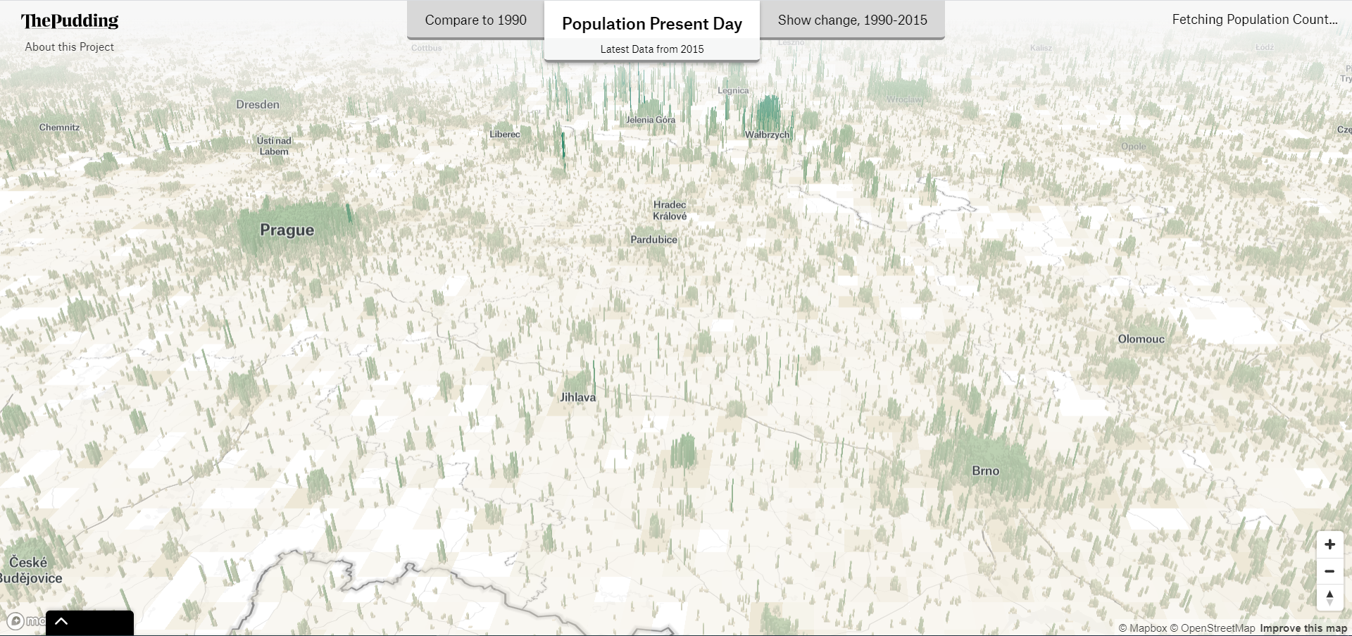
Technologický blog/časopis Pudding publikoval zajímavou mapu světové populace s názvem Human Terrain. Jedná se sice o starší projekt – již z roku 2018, ale i tak stojí za zmínku. Zároveň je potřeba se na data dívat kriticky, protože některá místa – např. v Polsku, nevypadají na mapě moc realisticky, však posuďte sami! Data pocházejí z […]
The post Tak trochu jiná mapa světové populace appeared first on GISportal.cz.
20200617 - volné místo - Uklízečka KP Děčín na Katastrálním úřadu pro Ústecký kraj
17.6.2020 7:35 ČÚZK - předpisy a opatření Katastrální úřad pro Ústecký kraj - Katastrální pracoviště Děčín zveřejnil novou aktualitu: Nabídka volného pracovního místa - Uklízečka Katastrálního pracoviště Děčín na KÚ pro Ústecký kraj20200617 - volné místo - Uklízečka KP Děčín na Katastrálním úřadu pro Ústecký kraj
17.6.2020 7:35 ČÚZK /Urady/Katastralni-urady/Katastralni-urady/Katastralni-urad-pro-Ustecky-kraj/O-uradu/Aktuality/20200617-volne-misto-Uklizecka-KP-Decin-na-KatUklízečka na Katastrálním pracovišti Děčín
17.6.2020 7:25 ČÚZK - volná místa Katastrální úřad pro Ústecký kraj Katastrální pracoviště Děčín vypisuje výběrové řízení na místo Uklízečka na Katastrálním pracovišti DěčínUklízečka na Katastrálním pracovišti Děčín
17.6.2020 7:25 ČÚZK /Urady/Katastralni-urady/Katastralni-urady/Katastralni-urad-pro-Ustecky-kraj/Volna-mista/DMS/Uklizecka-na-Katastralnim-pracovisti-DecinUklízečka na Katastrálním pracovišti Děčín
17.6.2020 7:25 ČÚZK - předpisy a opatření Katastrální úřad pro Ústecký kraj Katastrální pracoviště Děčínvypisuje výběrové řízení na místo
Uklízečka Katastrálního pracoviště Děčín na KÚ pro Ústecký kraj
Výběrové řízení - Inspektor/ka – technik Zeměměřického a katastrálního inspektorátu v Praze
17.6.2020 6:20 ČÚZK - předpisy a opatření Zeměměřický a katastrální inspektorát v Praze zveřejnil novou aktualitu: Oznámení o vyhlášení výběrového řízení na obsazení služebního místa Inspektor/ka – technik Zeměměřického a katastrálního inspektorátu v Praze (obor služby 55.)Výběrové řízení - Inspektor/ka – technik Zeměměřického a katastrálního inspektorátu v Praze
17.6.2020 6:20 ČÚZK /Urady/Zememericke-a-katastralni-inspektoraty/Zememericke-a-katastralni-inspektoraty/Zememericky-a-katastralni-inspektorat-v-Praze/O-uradu/Aktuality/Vyberove-rizeni-Inspektor-ka-–-pravnik-Zememer-(3)Výběrové řízení - Inspektor/ka – technik Zeměměřického a katastrálního inspektorátu v Praze
17.6.2020 6:20 ČÚZK - předpisy a opatření Zeměměřický a katastrální inspektorát v Praze zveřejnil novou aktualitu: Oznámení o vyhlášení výběrového řízení na obsazení služebního místa Inspektor/ka – technik Zeměměřického a katastrálního inspektorátu v Praze (obor služby 55.)Inspektor/ka-technik Zeměměřického a katastrálního inspektorátu v Praze (obor služby 55.)
17.6.2020 6:19 ČÚZK /Urady/Zememericke-a-katastralni-inspektoraty/Zememericke-a-katastralni-inspektoraty/Zememericky-a-katastralni-inspektorat-v-Praze/Uredni-deska/Oznameni-a-jina-uredni-sdeleni/Volna-mista/DMS/Inspektor-ka-technik-Zememerickeho-a-katastral-(1)Inspektor/ka-technik Zeměměřického a katastrálního inspektorátu v Praze (obor služby 55.)
17.6.2020 6:19 ČÚZK - volná místa Zeměměřický a katastrální inspektorát v Praze vypisuje výběrové řízení na místo Inspektor/ka-technik Zeměměřického a katastrálního inspektorátu v Praze (obor služby 55.)Inspektor/ka-technik Zeměměřického a katastrálního inspektorátu v Praze (obor služby 55.)
17.6.2020 6:19 ČÚZK - předpisy a opatření Zeměměřický a katastrální inspektorát v Prazevypisuje výběrové řízení na místo
Inspektor/ka-technik Zeměměřického a katastrálního inspektorátu v Praze (obor služby 55.)
Interview: Greg and Keith Bentley discuss open source, 4D digital twins and more
16.6.2020 18:32 Bentley SystemsPress Coverage
SPAR 3D, USA
Read the articleDigital Twin in Smart Cities
16.6.2020 18:19 Bentley SystemsPress Coverage
ConstructechTV, USA
Read the articleHere’s why digital twins are key to the utility of the future
16.6.2020 18:10 Bentley SystemsPress Coverage
Power Engineering, USA
Read the articleCityscape Digital uses Bluesky MetroVista Models to Create Property Development VR
16.6.2020 17:26 GISCafe.com Webcasts-Webinars Leicestershire, UK, 16 June 2020 - Cityscape Digital is using photorealistic 3D mesh models from aerial mapping company Bluesky to create live, …Velodyne Lidar Announces Multi-Year Partnership Agreement with Outsight
16.6.2020 17:25 GISCafe.com Webcasts-Webinars Outsight's 3D Cameras Incorporate Velodyne’s Lidar Sensors to Provide Advanced Intelligence to Airports, Shopping Malls and Train StationsSAN …
Barchart Releases Commodity Data Mapping Technology within cmdtyView
16.6.2020 17:25 GISCafe.com Webcasts-Webinars CHICAGO, June 16, 2020 — (PRNewswire) — Barchart, a leading provider of market data and technology services to the financial, …Leading UK space industry consortium calls for greater SME engagement for future satcom services
16.6.2020 17:21 GISCafe.com Webcasts-Webinars · Airbus, KBR, Leidos, Northrop Grumman and QinetiQ invite for SMEs to join its ‘Open …JOHAN V5 leverages EGNOS for extra precision
16.6.2020 13:17 European GNSS Agency
Winner of the GSA Special Prize at the 2013 Galileo Masters (former European Satellite Navigation Competition - ESNC), JOHAN has successfully established a start-up and is expanding its products portfolio. The company has developed GNSS-enabled motion sensors for location determination and performance measurement of sports teams, especially football and hockey players. The latest version of the sports tracker - V5 - leverages EGNOS/SBAS for extra accuracy.
The JOHAN V5 tracking system was developed in close collaboration with professional sports teams and offers accuracy, usability, and efficiency in a system that allows sports coaches to make quick and data-based decisions about player performance, injury risks, and training programmes.
The latest version of the sports tracker, the JOHAN V5, is equipped with a small powerful GNSS chip which, in combination with GNSS ground stations and sensor fusion, ensures high positioning accuracy. In addition, the V5 sensor also contains an integrated heart rate monitor, so that GNSS and heart rate data can be collected simultaneously from the players, who only need to wear one sensor. The latest version of the tracker offers real-time functionality, making it possible to translate live insights into training adjustments, through a user-friendly app.
Galileo for team spirit
The GNSS tracker – which is Galileo enabled – can determine a player’s position up to 1.5 metres and when this is combined with measurements from inertial sensors the level of accuracy increases even further. The monitor allows sports coaches or trainers to monitor the heart rate, number of sprints, distance covered and speed of all the team’s players.
Read this: SARA scores at football match
After using the tracer, players and coaches can review their performance, allowing players to spot weaknesses and improve their game over time and enabling coaches to make data-based tactical decisions to take advantage of players’ strengths and improve overall team performance.
“Sports trackers are yet another example of how Europe’s investment in space is being leveraged to provide innovative services in multiple sectors. In this case, Galileo’s accurate positioning is used to provide data-driven insights, allowing trainers to better strategize and enabling players to improve their performance,” said Fiammetta Diani, Head of Market Development at the GSA.
The V5 trackers are connected to a smart JOHAN control suitcase using new Bluetooth 5 technology, enabling live tracking. Bluetooth 5 technology has a range of over 400 meters, making it possible connect with the Live App to present accurate and consistent live tracking data.
GSA prize winner
Winning the GSA Special Prize at the ESNC in 2013 provided finance for incubation at an incubation centre of the project’s choice and JOHAN decided to cooperate with the European Space Agency’s Business Innovation Centre in Noordwijk. Working from this centre, the company ramped up development, adding customers and raising funds.
With kits to monitor teams of five players starting at EUR 995 per year, the company currently has more than 2,400 trackers in use by more than 120 teams in more than 24 countries, including Panathinaikos F.C. (Super League, Greece), Feyenoord Academy (Eredivisie, Netherlands), SC Braga Academy (Primeira Liga, Portugal) and the Icelandic national football team (FIFA, Iceland).
Media note: This feature can be republished without charge provided the European GNSS Agency (GSA) is acknowledged as the source at the top or the bottom of the story. You must request permission before you use any of the photographs on the site. If you republish, we would be grateful if you could link back to the GSA website (http://www.gsa.europa.eu).
JOHAN V5 leverages EGNOS for extra precision
16.6.2020 13:17 European GNSS AgencyWinner of the GSA Special Prize at the 2013 European Satellite Navigation Competition (ESNC), JOHAN has successfully established a start-up and is expanding its products portfolio. The company has developed GNSS-enabled motion sensors for location determination and performance measurement of sports teams, especially football and hockey players. The latest version of the sports tracker - V5 - leverages EGNOS/SBAS for extra accuracy.
The JOHAN V5 tracking system was developed in close collaboration with professional sports teams and offers accuracy, usability, and efficiency in a system that allows sports coaches to make quick and data-based decisions about player performance, injury risks, and training programmes.
The latest version of the sports tracker, the JOHAN V5, is equipped with a small powerful GNSS chip which, in combination with GNSS ground stations and sensor fusion, ensures high positioning accuracy. In addition, the V5 sensor also contains an integrated heart rate monitor, so that GNSS and heart rate data can be collected simultaneously from the players, who only need to wear one sensor. The latest version of the tracker offers real-time functionality, making it possible to translate live insights into training adjustments, through a user-friendly app.
Galileo for team spirit
The GNSS tracker – which is Galileo enabled – can determine a player’s position up to 1.5 metres and when this is combined with measurements from inertial sensors the level of accuracy increases even further. The monitor allows sports coaches or trainers to monitor the heart rate, number of sprints, distance covered and speed of all the team’s players.
Read this: SARA scores at football match
After using the tracer, players and coaches can review their performance, allowing players to spot weaknesses and improve their game over time and enabling coaches to make data-based tactical decisions to take advantage of players’ strengths and improve overall team performance.
“Sports trackers are yet another example of how Europe’s investment in space is being leveraged to provide innovative services in multiple sectors. In this case, Galileo’s accurate positioning is used to provide data-driven insights, allowing trainers to better strategize and enabling players to improve their performance,” said Fiammetta Diani, Head of Market Development at the GSA.
The V5 trackers are connected to a smart JOHAN control suitcase using new Bluetooth 5 technology, enabling live tracking. Bluetooth 5 technology has a range of over 400 meters, making it possible connect with the Live App to present accurate and consistent live tracking data.
GSA prize winner
Winning the GSA Special Prize at the ESNC in 2013 provided finance for incubation at an incubation centre of the project’s choice and JOHAN decided to cooperate with the European Space Agency’s Business Innovation Centre in Noordwijk. Working from this centre, the company ramped up development, adding customers and raising funds.
With kits to monitor teams of five players starting at EUR 995 per year, the company currently has more than 2,400 trackers in use by more than 120 teams in more than 24 countries, including Panathinaikos F.C. (Super League, Greece), Feyenoord Academy (Eredivisie, Netherlands), SC Braga Academy (Primeira Liga, Portugal) and the Icelandic national football team (FIFA, Iceland).
Media note: This feature can be republished without charge provided the European GNSS Agency (GSA) is acknowledged as the source at the top or the bottom of the story. You must request permission before you use any of the photographs on the site. If you republish, we would be grateful if you could link back to the GSA website (http://www.gsa.europa.eu).
Jak na tisk mapy? (jak na to – 2. část)
16.6.2020 11:46 T-MAPYThe post Jak na tisk mapy? (jak na to – 2. část) appeared first on T-MAPY spol. s r.o..
vedoucí oddělení hospodářské správy Katastrálního úřadu pro Pardubický kraj
16.6.2020 11:07 ČÚZK - předpisy a opatření Katastrální úřad pro Pardubický krajvypisuje výběrové řízení na místo
vedoucí oddělení hospodářské správy Katastrálního úřadu pro Pardubický kraj
vedoucí oddělení hospodářské správy Katastrálního úřadu pro Pardubický kraj
16.6.2020 11:07 ČÚZK /Urady/Katastralni-urady/Katastralni-urady/Katastralni-urad-pro-Pardubicky-kraj/Uredni-deska/Oznameni-a-jina-uredni-sdeleni/Volna-mista/vedouci-oddeleni-hospodarske-spravy-Katastraln-(1)vedoucí oddělení hospodářské správy Katastrálního úřadu pro Pardubický kraj
16.6.2020 11:07 ČÚZK - volná místa Katastrální úřad pro Pardubický kraj vypisuje výběrové řízení na místo vedoucí oddělení hospodářské správy Katastrálního úřadu pro Pardubický krajFSSCat/Ф-sat-1 ready for launch
16.6.2020 9:35 ESA Observing the Earth
The first artificial intelligence to be carried onboard a European Earth observation mission will be launched this week from Europe’s spaceport in Kourou, French Guiana. The pioneering artificial intelligence technology named ɸ-sat-1, pronounced PhiSat-1, will be the first experiment to improve the efficiency of sending vast quantities of data back to Earth.
Výběrová řízení
16.6.2020 9:09 ČÚZK /Urady/Katastralni-urady/Katastralni-urady/Katastralni-urad-pro-Kralovehradecky-kraj/Katastralni-pracoviste/KP-Jicin/O-uradu/Aktuality/Vyberova-rizeniVýběrová řízení
16.6.2020 9:09 ČÚZK - předpisy a opatření Katastrální úřad pro Královéhradecký kraj - Katastrální pracoviště Jičín zveřejnil novou aktualitu: Oznámení o vyhlášení výběrových řízení:na služební místo rada / odborný rada v oddělení právních vztahů k nemovitostem Katastrálního pracoviště Jičín
a
rada / odborný rada (pracovní poměr dle zákoníku práce na dobu určitou) v oddělení aktualizace katastru nemovitostí Katastrálního pracoviště Jičín
Výběrová řízení
16.6.2020 9:06 ČÚZK - předpisy a opatření Katastrální úřad pro Královéhradecký kraj - Katastrální pracoviště Jičín zveřejnil novou aktualitu: Oznámení o vyhlášení výběrových řízení:na služební místo rada / odborný rada v oddělení právních vztahů k nemovitostem Katastrálního pracoviště Jičín
a
rada / odborný rada (pracovní poměr dle zákoníku práce na dobu určitou) v oddělení aktualizace katastru nemovitostí Katastrálního pracoviště Jičín
Výběrová řízení
16.6.2020 9:06 ČÚZK /Urady/Katastralni-urady/Katastralni-urady/Katastralni-urad-pro-Kralovehradecky-kraj/O-uradu/Aktuality/Oznameni-o-vyhlaseni-vyberovych-rizeniInterview with Ben Ray, Project Manager at Zerion Software
16.6.2020 9:00 GISCafe.com Webcasts-Webinarsrada / odborný rada v oddělení právních vztahů k nemovitostem Katastrálního pracoviště Jičín
16.6.2020 8:48 ČÚZK - volná místa Katastrální úřad pro Královéhradecký kraj - Katastrální pracoviště Jičín vypisuje výběrové řízení na místo rada / odborný rada v oddělení právních vztahů k nemovitostem Katastrálního pracoviště Jičínrada / odborný rada v oddělení právních vztahů k nemovitostem Katastrálního pracoviště Jičín
16.6.2020 8:48 ČÚZK - předpisy a opatření Katastrální úřad pro Královéhradecký kraj - Katastrální pracoviště Jičínvypisuje výběrové řízení na místo
rada / odborný rada v oddělení právních vztahů k nemovitostem Katastrálního pracoviště Jičín