


zprávy
zdroje zpráv:Rada / odborný rada v oddělení právních vztahů k nemovitostem Katastrálního pracoviště Teplice na Ka
26.6.2020 10:37 ČÚZK /Urady/Katastralni-urady/Katastralni-urady/Katastralni-urad-pro-Ustecky-kraj/Uredni-deska/Oznameni-a-jina-uredni-sdeleni/Volna-mista/DMS/Rada-odborny-rada-v-oddeleni-pravnich-vztahu-k-nRada / odborný rada v oddělení právních vztahů k nemovitostem Katastrálního pracoviště Teplice na Ka
26.6.2020 10:37 ČÚZK - volná místa Katastrální úřad pro Ústecký kraj Katastrální pracoviště Teplice vypisuje výběrové řízení na místo Rada / odborný rada v oddělení právních vztahů k nemovitostem Katastrálního pracoviště Teplice na KaRada / odborný rada v oddělení právních vztahů k nemovitostem Katastrálního pracoviště Teplice na Ka
26.6.2020 10:37 ČÚZK - předpisy a opatření Katastrální úřad pro Ústecký kraj Katastrální pracoviště Teplicevypisuje výběrové řízení na místo
Rada / odborný rada v oddělení právních vztahů k nemovitostem Katastrálního pracoviště Teplice na Katastrálním úřadu pro Ústecký kraj
Earth from Space: Peruvian Andes
26.6.2020 10:00 ESA Observing the Earth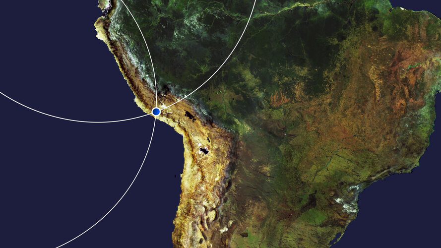 Video:
00:03:47
Video:
00:03:47
In this week's edition of the Earth from Space programme, the Andes mountains, in southern Peru, are featured in this false-colour image captured by the Copernicus Sentinel-2 mission
Peruvian Andes
26.6.2020 10:00 ESA Observing the Earth Image:
The Andes mountains, in southern Peru, are featured in this false-colour image captured by the Copernicus Sentinel-2 mission.
Image:
The Andes mountains, in southern Peru, are featured in this false-colour image captured by the Copernicus Sentinel-2 mission.
Earth from Space: Peruvian Andes
26.6.2020 10:00 ESA Observing the Earth Video:
00:03:47
Video:
00:03:47
In this week's edition of the Earth from Space programme, the Andes mountains, in southern Peru, are featured in this false-colour image captured by the Copernicus Sentinel-2 mission
HxGN Content Program updates 3 million square kilometres of aerial data in U.S., Europe in 2020
26.6.2020 9:00 GISCafe.com Webcasts-Webinars WASHINGTON, D.C., USA (23 June 2020) — Hexagon’s Geosystems division announced today the HxGN Content Program, the largest library of …Take part in citizen science for food security
26.6.2020 9:00 ESA Observing the Earth
The International Institute for Applied System Analysis (IIASA) and ESA, in partnership with the Wilson Center, the Earth Day Network and the US State Department, are giving citizens the opportunity to get involved in one of the world’s most challenging problems: ensuring a nutritious food supply to meet the needs of the growing global population.
Take part in citizen science for food security
26.6.2020 9:00 ESA Observing the Earth
The International Institute for Applied System Analysis (IIASA) and ESA, in partnership with the Wilson Center, the Earth Day Network and the US State Department, are giving citizens the opportunity to get involved in one of the world’s most challenging problems: ensuring a nutritious food supply to meet the needs of the growing global population.
1Spatial: Environment Agency Application Build and Managed Service Win
26.6.2020 9:00 GISCafe.com Webcasts-Webinars Cambridge, UK, 25th June 2020, (www.1spatial.com) 1Spatial, the global spatial software and solutions company is pleased to announce it has been …Mapy.cz na Slovensku v tichosti přecházejí na OSM data
26.6.2020 8:32 GISportal.cz
V záři novinek, jako je zobrazení intenzity dopravy v mobilní aplikaci, se bez větší pozornosti odehrává také změna, která pravděpodobně nepotěší uživatele ze Slovenska (nebo ty, co s mapami na Slovensko vyjíždějí). Z vlastních podrobných datových podkladů tu totiž populární mapový portál přechází na data z OpenStreetMap stejně jako u ostatních států. Jen při letmém […]
The post Mapy.cz na Slovensku v tichosti přecházejí na OSM data appeared first on GISportal.cz.
GIS v plánování měst a regionů 2020 (pozvánka)
26.6.2020 8:20 GISportal.cz
Česká asociace pro geoinformace (CAGI) a Vysoká škola regionální rozvoje a Bankovní institut – AMBIS, a.s. Vás srdečně zvou k účasti na 6. ročníku konference která se uskuteční v Praze v termínu 24. 9. 2020. Téma konference: Bezpečný a udržitelný turismus Tématické okruhy: Církevní památky jako fenomén cestovního ruchu Limity cestovního ruchu Téma pravidelného workshopu: Vyhodnocení zdravotního stavu stromů […]
The post GIS v plánování měst a regionů 2020 (pozvánka) appeared first on GISportal.cz.
Upozornění
26.6.2020 8:13 ČÚZK /Urady/Katastralni-urady/Katastralni-urady/Katastralni-urad-pro-Ustecky-kraj/Katastralni-pracoviste/KP-Decin/O-uradu/Aktuality/UpozorneniUpozornění
26.6.2020 8:13 ČÚZK - předpisy a opatření Katastrální úřad pro Ústecký kraj - Katastrální pracoviště Děčín zveřejnil novou aktualitu: UpozorněníVážení klienti,
Z důvodu přerušení dodávky elektrické energie bude dne 2.7.2020 od 8:00 do 11:00 Katastrální pracoviště Děčín uzavřeno pro veřejnost.
Děkujeme za pochopení
Ing. Ivo Apfelbeck, ředitel pracoviště
Zveřejnění obsahu informací poskytnutých na žádost dle zákona č. 106/1999 Sb. za rok 20
26.6.2020 6:39 ČÚZK /Urady/Zememericke-a-katastralni-inspektoraty/Zememericke-a-katastralni-inspektoraty/Zememericky-a-katastralni-inspektorat-v-Brne/Casto-hledane-informace/Poskytovani-informaci-106-1999-Sb/Zverejneni-obsahu-informaci-poskytnutych-na-za-(1)/Zverejneni-obsahu-informaci-poskytnutych-na-za-(4)Zveřejnění obsahu informací poskytnutých na žádost dle zákona č. 106/1999 Sb. za rok 20
26.6.2020 6:39 ČÚZK - předpisy a opatření Zeměměřický a katastrální inspektorát v Brnězveřejňuje obsah informace poskytnutých na žádost dle zákona č. 106/1999 Sb. za rok
2020
Katastrální mapa v rastrové podobě poskytovaná v e-shopu
26.6.2020 2:00 Cenia - Katalog metadat ČR - INSPIRE Katastrální mapa v rastrové podobě je poskytována za úplatu a obsahuje analogovou mapu s kompletní kresbou. Analogová mapa pokrývá 2,98 % území České republiky, což je 2 346,67km2. Více katastrální vyhláška č.357/2013 Sb. v platném znění.INSPIRE téma Parcely (CP)
26.6.2020 2:00 Cenia - Katalog metadat ČR - INSPIRE Data odpovídají směrnici INSPIRE pro téma katastrální parcely (CP). Vychází z katastrální mapy, která je závazným státním mapovým dílem velkého měřítka, obsahuje body polohového bodového pole, polohopis a popis a může mít formu digitální mapy, analogové mapy nebo digitalizované mapy. Data publikovaná v rámci INSPIRE obsahují pouze katastrální území (pro celou Českou Republiku) a parcely a jejich hranice z území, kde je digitální mapa (k 22. 06. 2020 je to 96,81% území České republiky, t.j. 76 350,93km2). Více katastrální zákon 344/1992 SB., katastrální vyhláška č.26/2007 Sb. v platném znění a INSPIRE Data Specification on Cadastral Parcels v 3.0.1. Data ve formátu GML 3.2.1 jsou validní proti schématu XML pro INSPIRE téma Parcely ve verzi 4.0 a proti schématu pro prostorová data ELF ve verzi 1.0.INSPIRE téma Rozšířené Parcely (CPX)
26.6.2020 2:00 Cenia - Katalog metadat ČR - INSPIRE Rozšíření má za cíl poskytovat katastrální mapu s obsahem podle vyhlášky ve vektorové podobě ve struktuře plně v souladu se strukturou danou směrnicí INSPIRE. Data rozšiřují směrnici INSPIRE pro téma katastrální parcely (CP) o věcná břemena, geodetické body, další prvky mapy, původní obloukovou geometrii a o parcely určené definičním bodem (ty pouze v oblastech s analogovou mapou). Vychází z katastrální mapy, která je závazným státním mapovým dílem velkého měřítka, obsahuje body polohového bodového pole, polohopis a popis a může mít formu digitální mapy, analogové mapy nebo digitalizované mapy. Publikovaná data obsahují katastrální území pro celou Českou Republiku, parcely a jejich hranice, věcná břemena, další prvky mapy a původní obloukovou geometrii z území, kde je digitální mapa (k 22. 06. 2020 je to 96,81% území České republiky, t.j. 76 350,93km2) a ve zbytku území katastrální parcely určené pouze definičním bodem (tedy bez hranic a polygonu). Katastrální parcely a hranice obsahují oproti datové sadě INSPIRE některé atributy navíc. Jedná se o typ hranice, způsob využití území, druh pozemku, vazbu na budovu a o mapové značky. Více katastrální zákon 344/1992 SB., katastrální vyhláška č.26/2007 Sb. v platném znění a INSPIRE Data Specification on Cadastral Parcels v 3.0.1. Data ve formátu GML 3.2.1 jsou validní proti schématu XML pro Rozšířené Parcely (CPX) ve verzi 4.0.INSPIRE téma Budovy (BU)
26.6.2020 2:00 Cenia - Katalog metadat ČR - INSPIRE Data odpovídají směrnici INSPIRE pro téma budovy (BU). Data pochází částečně z projektu RÚIAN (Registr územní identifikace, adres a nemovitostí), který je součástí základních registrů České Republiky a obsahuje informace o územní identifikaci, adresách a nemovitostech, a částečně z ISKN (Informační systém katastru nemovistostí). Zdrojem informací o budovách v ISKN je objekt Stavba, v RÚIAN je to Stavební objekt. Většina Staveb je zároveň Stavebními objekty, ale jsou případy, kdy tomu tak není. Kromě Budov datová sada obsahuje i části budov, které jsou pro potřeby INSPIRE vyjádřeny vchody z RÚIAN. Vchody obsahují informace o počtu podlaží, technickoekonomických atributech apod. Datová sada pokrývá celé území české republiky. V datové sadě není uvedeno 1,14%, t.j. 48357 budov (k 22. 06. 2020), protože neobsahují definiční bod ani polygon. Více v zákoně č. 111/2009 Sb., o základních registrech, ve vyhlášce č. 359/2011 Sb., o základním registru územní identifikace, adres a nemovitostí v platných zněních, v zákoně 256/2013 Sb., o katastru nemovitostí, v katastrální vyhlášce č. 357/2013 Sb. v platném znění a INSPIRE Data Specification on Buildings v 3.0 z 13.12.2013. Data ve formátu GML 3.2.1 jsou validní proti schématu XML pro INSPIRE téma Budovy ve verzi 4.0 a proti schématu pro prostorová data ELF ve verzi 1.0.INSPIRE téma Adresy (AD)
26.6.2020 2:00 Cenia - Katalog metadat ČR - INSPIRE Data odpovídají směrnici INSPIRE pro téma adresy (AD). Vychází především z projektu RÚIAN (Registr územní identifikace, adres a nemovitostí), který je součástí základních registrů České Republiky a obsahuje informace o územní identifikaci, adresách a nemovitostech. Data publikovaná v rámci INSPIRE obsahují pouze adresní místa a jejich komponenty, kterými jsou stát, obec, část obce, městský obvod v Praze (MOP), městký obvod/městská část (MO/MČ), ulice a pošta a to na území celé České Republiky. Obsahují rozvněž geometrii, která určuje definiční bod adresního místa. V datové sadě nění uvedeno 1,14%, t.j. 33472 adresních míst (k 22. 06. 2020), protože neobsahují definiční bod, podle kterého by je bylo možné prostorově určit. Více v zákoně č. 111/2009 Sb., o základních registrech a ve vyhlášce č. 359/2011 Sb., o základním registru územní identifikace, adres a nemovitostí v platných zněních a INSPIRE Data Specification on Addresses v 3.0.1 z 26.4.2010. Data ve formátu GML 3.2.1 jsou validní proti schématu XML pro INSPIRE téma Adresy ve verzi 4.0 a proti schématu pro prostorová data ELF ve verzi 1.0.Katastrální mapa ve formátech DGN a DXF poskytovaná v e-shopu
26.6.2020 2:00 Cenia - Katalog metadat ČR - INSPIRE Katastrální mapa je závazným státním mapovým dílem velkého měřítka, obsahuje body polohového bodového pole, polohopis a popis. Katastrální mapa ve vektorové podobě je poskytována zdarma ve formátu DGN a DXF a obsahuje prvky Digitální katastrální mapy (DKM) a Katastrální mapy digitalizované (KMD), tedy bodová pole, budovy, další prvky mapy, hranice parcel, katastrální hranice, parcely katastru nemovitostí, prvky orientační mapy a hranice věcného břemene. Z důvodu použití formátu DGN produkt neobsahuje značky na liniích a oblouky jsou nahrazeny lomenými čárami. Katastrální mapa ve vektorové podobě k 22. 06. 2020 pokrývá 96,81% území České republiky, t.j. 76 350,93km2. Více katastrální vyhláška č.357/2013 Sb. v platném znění.Airbus and ESA sign agreement to continue ISS operations
26.6.2020 0:44 GISCafe.com Webcasts-Webinars Comprehensive services contract for 2020, worth around €16 million, ensures operation and use of European ISS componentsResearch has been …ROK Technologies is the First Esri Silver Partner Awarded ArcGIS Cloud Services Specialty Designation
25.6.2020 23:49 GISCafe.com Webcasts-Webinars This designation is exclusively reserved for those who have expertise in deploying and managing ArcGIS in cloud environments; providing services for …Worldwide Services Market Growth Disrupted by Economic Impact of COVID-19, According to IDC
25.6.2020 20:43 GISCafe.com Webcasts-Webinars FRAMINGHAM, Mass. — (BUSINESS WIRE) — June 25, 2020 —In April, International Data Corporation (IDC) forecast worldwide IT …
Cartegraph Acquires PenBay Solutions, Combines Best-of-breed Infrastructure Management Tech
25.6.2020 20:43 GISCafe.com Webcasts-Webinars Esri Partners Join Forces to Help Organizations Seamlessly Manage Every Infrastructure Asset: Indoors, Outdoors, Above and Below GroundDUBUQUE, …
Concerns About Chinese Made Drones Could Drive the Commercial Drone Industry to New Heights
25.6.2020 20:43 GISCafe.com Webcasts-Webinars LOS ANGELES, June 25, 2020 — (PRNewswire) — USA News Group – U.S. government agencies have instituted policy bans on DJI and …Maxar Technologies Announces Exercise of Call Option to Acquire Vricon, Inc.
25.6.2020 20:43 GISCafe.com Webcasts-Webinars WESTMINSTER, Colo. — (BUSINESS WIRE) — June 25, 2020 —Maxar Technologies (NYSE:MAXR) (TSX:MAXR), a trusted partner and innovator …
Topcon Announces the European Launch of MYAH
25.6.2020 16:26 GISCafe.com Webcasts-Webinars Company Introduces Comprehensive Management Tool for Myopia and Dry EyeCAPELLE A/D IJSSEL, Netherlands — (BUSINESS WIRE) — June 24, 2020 …
National Geospatial-Intelligence Agency Signs CRADA with Capella Space
25.6.2020 16:26 GISCafe.com Webcasts-Webinars Capella Space becomes first U.S. commercial SAR satellite company to sign agreement with the NGA to support research effortsSAN FRANCISCO, June 25, …
Firefighters Support Alliance Launches Interactive Map, Tracking Economic Impact of Firefighters
25.6.2020 16:26 GISCafe.com Webcasts-Webinars ARLINGTON,Va., June 25, 2020 — (PRNewswire) — Firefighters Support Alliance has launched an initiative to help voters understand …Oznámení o plánované výluce telekomunikačních služeb dne 16.07.2020
25.6.2020 14:46 ČÚZK - předpisy a opatření Katastrální úřad pro Jihomoravský kraj - Katastrální pracoviště Znojmo zveřejnil novou aktualitu: Oznámení o plánované výluce telekomunikačních služeb dne 16.07.2020.Podrobnosti zde
Oznámení o plánované výluce telekomunikačních služeb dne 16.07.2020
25.6.2020 14:46 ČÚZK - předpisy a opatření Katastrální úřad pro Moravskoslezský kraj - Katastrální pracoviště Znojmo zveřejnil novou aktualitu: Oznámení o plánované výluce telekomunikačních služeb dne 16.07.2020.Podrobnosti zde
Space agencies join forces to produce global view of COVID-19 impacts
25.6.2020 14:00 ESA Observing the Earth
In an unprecedented collaboration, ESA, NASA and JAXA (Japan Aerospace Exploration Agency) have created a new tool that combines a wealth of data from Earth-observing satellites to monitor the worldwide impacts of COVID-19. This new online platform is now available to the public.
Na serverech ČÚZK dochází od 2
25.6.2020 12:59 GEUSware Na serverech ČÚZK dochází od 20.1.2020 postupně k vypínání protokolů TLS 1.0 a 1.1 a běží pouze protokol 1.2. Tato změna nemá vliv na aktuální verzi GEUS 24.0. V programu GEUS 23.0 a nižších verzích nyní přestaly fungovat funkce využívající data ze serveru services.cuzk.cz.Výstava: Dědictví zmizelých krajin Česka [Katedra aplikované geoinformatiky a kartografie, byTopic]
25.6.2020 11:25 Katedra aplikované geoinformatiky a kartografie Přf UK Srdečně Vás zveme na výstavu Dědictví zmizelých krajin Česka, která je k zhlédnutí od 22.6. do 31.8. 2020 v předsálí Mapové sbírky, Albertov 6, Praha 2. Výstava představuje výstupy projektu „Dědictví zaniklých krajin: identifikace, rekonstrukce a zpřístupnění“ vytvořené v letech 2018 a 2019. Vstup volný.Odstávka Geoportálu Jihočeského kraje
25.6.2020 7:35 Jihočeský kraj V pondělí 29.6.2020 bude prováděna údržba na serverových komponentách Geoportálu od 12:00 do večerních hodin. Během odstávky nebudou k dispozici evidenční a mapové aplikace a zároveň nebude možné vydávat prostřednictvím Geoportálu data. Děkujeme za pochopení.Odstávka Geoportálu Jihočeského kraje
25.6.2020 7:35 Jihočeský kraj V pondělí 29.6.2020 bude prováděna údržba na serverových komponentách Geoportálu od 12:00 do večerních hodin. Během odstávky nebudou k dispozici evidenční a mapové aplikace a zároveň nebude možné vydávat prostřednictvím Geoportálu data. Děkujeme za pochopení.Výluka telefonního spojení
25.6.2020 7:23 ČÚZK - předpisy a opatření Katastrální úřad pro Středočeský kraj - Katastrální pracoviště Příbram zveřejnil novou aktualitu: Dne 25. 6. 2020 nebude dostupné telefonické spojení s pracovištěm. Oprava telefonní ústředny. Za komplikace se omlouváme.Výluka telefonního spojení
25.6.2020 7:23 ČÚZK /Urady/Katastralni-urady/Katastralni-urady/Katastralni-urad-pro-Stredocesky-kraj/Katastralni-pracoviste/KP-Pribram/O-uradu/Aktuality/Vyluka-telefonniho-spojeni Ohlášený konec měsíčních pronájmů licencí Autodesk
Nefunkční telefony v budově ústředí
25.6.2020 0:00 Státní pozemkový úřad Praha, 25. června 2020: Upozornění! V budově ústředí v Husinecké ulici 1024/11a , Praha 3 - Žižkov jsou aktuálně zcela nefunkční telefony. Nelze volat ani přijímat hovory. Na odstranění poruchy pracuje telefonní operátor. Pro kontakt s pracovišti využijte e-mailové adresy pracovišť, jejich seznam naleznete zde: https://www.spucr.cz/kontakty/seznam-kontaktu. Velmi se omlouváme za případné problémy spojené s výpadkem telefonického spojení. Děkujeme za pochopení.Nefunkční telefony v budově ústředí
25.6.2020 0:00 Státní pozemkový úřad Praha, 25. června 2020: Upozornění! V budově ústředí v Husinecké ulici 1024/11a , Praha 3 - Žižkov jsou aktuálně zcela nefunkční telefony. Nelze volat ani přijímat hovory. Na odstranění poruchy pracuje telefonní operátor. Pro kontakt s pracovišti využijte e-mailové adresy pracovišť, jejich seznam naleznete zde: https://www.spucr.cz/kontakty/seznam-kontaktu. Velmi se omlouváme za případné problémy spojené s výpadkem telefonického spojení. Děkujeme za pochopení.Seequent launches contaminated site solution to aid environmental sustainability
24.6.2020 23:27 GISCafe.com Webcasts-Webinars CHRISTCHURCH, NZ, 23 June 2020 – Global geoscience software company Seequent has released a Contaminants extension for its 3D modelling and …L3Harris Technologies Wins Four NOAA Study Contracts for Future Satellite Constellation
24.6.2020 22:50 GISCafe.com Webcasts-Webinars Highlights:Uses high-performance solutions to deliver specific mission requirements
Provides a low-risk solution to meet NOAA’s future …
HERE Technologies promotes Stephen Patak to Senior Vice President and General Manager of the Americas region
24.6.2020 20:34 GISCafe.com Webcasts-Webinars June 24, 2020 Chicago, IL – HERE Technologies, a location data and platform company, today announced that Stephen Patak has been named Senior Vice …Kespry Announces Summer 2020 Aerial Intelligence Platform Release
24.6.2020 20:34 GISCafe.com Webcasts-Webinars Kespry drone analytics platform update delivers new Haul Roads feature, DJI Phantom 4 RTK integration, enhanced hail detection, and seamless …AgEagle Aerial Systems Announces Pricing of $7 Million Registered Direct Offering
24.6.2020 17:12 GISCafe.com Webcasts-Webinars NEODESHA, Kan., June 24, 2020 (GLOBE NEWSWIRE) -- AgEagle Aerial Systems Inc. (NYSE American: UAVS), an industry leading provider of unmanned …Omdia Index ranks HERE as top global location platform for enterprises
24.6.2020 15:22 GISCafe.com Webcasts-Webinars “HERE is once again in pole position, widening the gap with Google” - OmdiaMitsubishi Corporation and NTT’s investment in HERE highlight …Quantum Spatial Names Cherie Jarvis Director of eGIS Group
24.6.2020 15:22 GISCafe.com Webcasts-Webinars eGIS Team Manages Complex GIS Projects for Federal Government Clients, Leveraging Agile MethodologiesHOLLYWOOD, Fla., June 24, 2020 — …
Unacast Unveils Unacast Neighborhood Insights for Real Estate and Retail Industries
24.6.2020 15:22 GISCafe.com Webcasts-Webinars First of its kind tool provides actionable human mobility insights for business planning amid COVID-19 recoveryNEW YORK, June 24, 2020 — …
Woolpert to Provide Information Technology Archives and Information Management (AIM) Support Services for DOE Office of Legacy Management
24.6.2020 15:22 GISCafe.com Webcasts-Webinars The IDIQ contract will help the Legacy Management Support team deliver long-term sustainment of Department of Energy post-closure sites across the …Pozvánka na GIS Express 2020 on-line
24.6.2020 11:01 Geotronics GIS - Dovolujeme si Vás pozvat na říjnový GIS Express, letos netradičně on-line.Eos Positioning Systems Releases Eos Tools Pro for Windows
24.6.2020 9:00 GISCafe.com Webcasts-Webinars Eos’s new GNSS app for Windows 10 devices is loaded with new, powerful features and a colorful user interface. For developers, integrating …UPDATE: QGIS 3.14 Pí je ke stažení
24.6.2020 8:12 GISportal.cz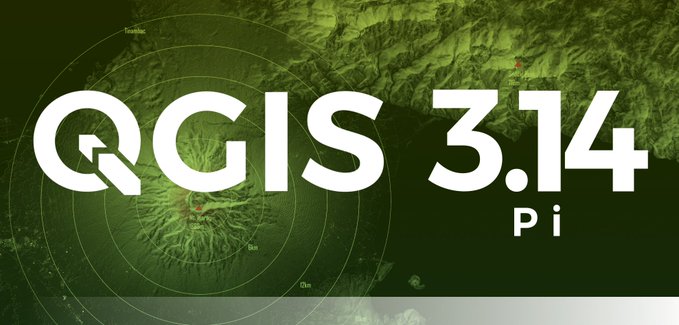
UPDATE: dodáno video s přehledem změn (viz níže). Oblíbeny open-source QGIS vychází v nové verzi a to QGIS 3.14 π (Pí). Tradiční changelog s popisem je dostupný na webu, nás však zaujala například možnost otvírání více atributových tabulek formou záložek.
The post UPDATE: QGIS 3.14 Pí je ke stažení appeared first on GISportal.cz.
QGIS 3.14 Pí je ke stažení
24.6.2020 8:12 GISportal.czOblíbeny open-source QGIS vychází v nové verzi a to QGIS 3.14 π (Pí). Tradiční changelog s popisem je dostupný na webu, nás však zaujala například možnost otvírání více atributových tabulek formou záložek.
The post QGIS 3.14 Pí je ke stažení appeared first on GISportal.cz.
USGIF Announces 11 New Board Members For 2020-2021
24.6.2020 2:26 GISCafe.com Webcasts-Webinars USGIF elects new members to its board of directors; including a new chairman of the boardHerndon, VA (June 23, 2020) --- The United States …
E-on Software Announces the Availability of its R5 Release for VUE, PlantFactory and PlantCatalog Solutions
24.6.2020 1:01 GISCafe.com Webcasts-Webinars e-on software's R5 release adds Machine-Learning-based interactive and offline path-tracing denoising, vastly improved displacement, SatMaps …Happy birthday Sentinel-2A: Five Years of Environmental Insights
24.6.2020 0:53 GISCafe.com Webcasts-Webinars Friedrichshafen, 23 June 2020 – Sentinel-2A has orbited Earth more than 26,000 times – and travelled nearly 1.2 billion kilometers in its …Maxar Technologies Announces its Intention to Acquire Vricon, Inc. to Accelerate Growth in Emerging Markets for 3D Technology and Extend its Lead in Earth Intelligence
24.6.2020 0:31 GISCafe.com Webcasts-Webinars WESTMINSTER, Colo. — (BUSINESS WIRE) — June 23, 2020 —Maxar Technologies (NYSE:MAXR) (TSX:MAXR), a trusted partner and innovator …
SkyWatch and AgIntegrated to Work Together to Bring Earth Observation Satellite Data to the Agriculture Industry
24.6.2020 0:31 GISCafe.com Webcasts-Webinars AgIntegrated's customers will now have access to satellite imagery ranging from 15m to 45cm resolution, thanks to a new integration with SkyWatch …Esri Named a Leader in Location Intelligence Platforms Report by Independent Market Research Firm
24.6.2020 0:31 GISCafe.com Webcasts-Webinars REDLANDS, Calif. — (BUSINESS WIRE) — June 23, 2020 —Esri, the global leader in GIS, location intelligence, and mapping …
SkyWatch and AgIntegrated to Work Together to Bring Earth Observation Satellite Data to the Agriculture Industry
23.6.2020 16:58 GISCafe.com Webcasts-Webinars June 23, 2020 -- With the ever-increasing need for remotely sensed imagery data in agriculture, SkyWatch Space Applications Inc. (SkyWatch) has …3D at Depth Launches Remote Sensing and Remote Data Control Technology
23.6.2020 16:30 GISCafe.com Webcasts-Webinars LONGMONT, Colo., June 23, 2020 (GLOBE NEWSWIRE) -- 3D at Depth Inc., the world’s leading expert in subsea laser (SL) LIDAR technology, survey …Unique collaboration releases updated official boundary and geospatial data for Europe
23.6.2020 16:30 GISCafe.com Webcasts-Webinars June 23, 2020 -- National Mapping, Cadastral and Land Registration authorities across Europe have provided official data for the latest seamless …SMOS monitoring droughts
23.6.2020 16:19 ESA Observing the Earth Video:
00:03:00
Video:
00:03:00
In orbit for more than a decade, ESA’s Earth Explorer satellite SMOS has not only exceeded its planned lifespan, but also surpassed its original scientific goals. Built to demonstrate new technology in space and address gaps in our scientific understanding of how Earth works as a system, this remarkable mission is now also being used for a number of practical applications. With drought seemingly more commonplace, entrepreneurs are using information on soil moisture from SMOS and data from other satellites to generate commercial data products for the insurance market, ultimately bringing benefits to farmers.
This video includes interviews of :
Klaus Scipal: SMOS Mission Manager, ESA, Soundbites in English & German
Thijs van Leeuwen: CEO of VanderSat – Soundbites in English & Dutch
Marcel Andriesse: Senior underwriter agri-culture Swiss Re - Soundbites in English & Dutch
rada/odborný rada – kontrola listin určených k záznamu
23.6.2020 15:35 ČÚZK - předpisy a opatření Katastrální úřad pro hlavní město Prahu - Katastrální pracoviště Prahavypisuje výběrové řízení na místo
rada/odborný rada – kontrola listin určených k záznamu
rada/odborný rada – kontrola listin určených k záznamu
23.6.2020 15:35 ČÚZK - volná místa Katastrální úřad pro hlavní město Prahu - Katastrální pracoviště Praha vypisuje výběrové řízení na místo rada/odborný rada – kontrola listin určených k záznamurada/odborný rada – právník Katastrálního úřadu pro hlavní
23.6.2020 15:31 ČÚZK /Urady/Katastralni-urady/Katastralni-urady/Katastralni-urad-pro-hlavni-mesto-Prahu/Uredni-deska/Oznameni-a-jina-uredni-sdeleni/Volna-mista/DMS/rada-odborny-rada-–-pravnik-Katastralniho-uradu-prrada/odborný rada – právník Katastrálního úřadu pro hlavní
23.6.2020 15:31 ČÚZK - předpisy a opatření Katastrální úřad pro hlavní město Prahu - Katastrální pracoviště Prahavypisuje výběrové řízení na místo
rada/odborný rada – právník Katastrálního úřadu pro hlavní
rada/odborný rada – právník
23.6.2020 15:31 ČÚZK - předpisy a opatření Katastrální úřad pro hlavní město Prahu - Katastrální pracoviště Prahavypisuje výběrové řízení na místo
rada/odborný rada – právník
rada/odborný rada – právník
23.6.2020 15:31 ČÚZK /Urady/Katastralni-urady/Katastralni-urady/Katastralni-urad-pro-hlavni-mesto-Prahu/Uredni-deska/Oznameni-a-jina-uredni-sdeleni/Volna-mista/DMS/rada-odborny-rada-–-pravnik-Katastralniho-uradu-prrada/odborný rada – právník Katastrálního úřadu pro hlavní
23.6.2020 15:31 ČÚZK - volná místa Katastrální úřad pro hlavní město Prahu - Katastrální pracoviště Praha vypisuje výběrové řízení na místo rada/odborný rada – právník Katastrálního úřadu pro hlavnírada/odborný rada – právník
23.6.2020 15:31 ČÚZK - volná místa Katastrální úřad pro hlavní město Prahu - Katastrální pracoviště Praha vypisuje výběrové řízení na místo rada/odborný rada – právníkrada/odborný rada - právník
23.6.2020 15:08 ČÚZK - předpisy a opatření Katastrální úřad pro hlavní město Prahu Katastrální pracoviště Prahavypisuje výběrové řízení na místo
rada/odborný rada - právník
Oznámení o plánované výluce telekomunikačních služeb dne 16.07.2020
23.6.2020 14:45 ČÚZK - předpisy a opatření Katastrální úřad pro Jihomoravský kraj - Katastrální pracoviště Znojmo zveřejnil novou aktualitu:Oznámení o plánované výluce telekomunikačních služeb dne 16.07.2020
Oznámení o plánované výluce telekomunikačních služeb dne 16.07.2020
23.6.2020 14:45 ČÚZK /Urady/Katastralni-urady/Katastralni-urady/Katastralni-urad-pro-Jihomoravsky-kraj/Katastralni-pracoviste/KP-Znojmo/O-uradu/Aktuality/Oznameni-o-planovane-vyluce-telekomunikacnich-(1)Robert Mankowski, SVP of Digital Cities, Bentley Systems, Joins the Executive Board of the World Geospatial Industry Council
23.6.2020 14:31 Bentley SystemsEXTON, Pa. – June 23, 2020 – Bentley Systems, Incorporated, a leading global provider of comprehensive software and digital twin cloud services for advancing the design, construction, and operations of infrastructure, announces that Robert Mankowski, Bentley’s senior vice president of digital cities, has been named to the executive board of the World Geospatial Industry Council.
Mankowski leads Bentley’s digital cities solution area, which provides infrastructure engineering, digital twin software, and services to help cities that are going digital. He has over 20 years’ experience in software development and has co-invented several technologies now used in the OpenFlows product line. Bentley’s digital cities applications enable engineers to plan and design more efficient city infrastructure.
“I am honored to serve on the WGIC executive board and use my experience and knowledge of both the geospatial industry and the infrastructure industry to further advance WGIC’s mission and objectives,” said Mankowski.
Mankowski joined Bentley in 2004 as part of Bentley’s acquisition of Haestad Methods, a pioneer in object-oriented hydraulic analysis software, where he served as chief technology officer. He earned a Bachelor of Science degree in civil engineering from Drexel University and is a licensed professional engineer.
Mankowski replaces Ted Lamboo on the World Geospatial Industry Council board. Formerly with Bentley, Lamboo is now CEO of Digital Construction Works, a new digital automation, integration, and digital twinning services and fit-for-purpose solutions company formed as part of a joint venture between Bentley and Topcon Positioning Group.
Bentley is a co-founder of the World Geospatial Industry Council, which acts as a collaborative platform for advancing the role of the geospatial industry and strengthening its contributions to society and the world economy.
Mankowski is one of four new members the World Geospatial Industry Council named to its executive board. More information about the appointments is available here.
Image: Robert Mankowski
Caption: Robert Mankowski, Bentley’s senior vice president of digital cities, was recently appointed to the executive board of the World Geospatial Industry Council.
##
About WGIC
The World Geospatial Industry Council is a registered not-for-profit trade association of commercial geospatial companies representing the entire value chain of the geospatial ecosystem. For more information about WGIC, visit: https://wgicouncil.org/
About Bentley Systems
Bentley Systems is a leading global provider of software solutions to engineers, architects, geospatial professionals, constructors, and owner-operators for the design, construction, and operations of infrastructure. Bentley’s MicroStation-based engineering and BIM applications, and its digital twin cloud services, advance the project delivery (ProjectWise) and the asset performance (AssetWise) of transportation and other public works, utilities, industrial and resources plants, and commercial and institutional facilities.
Bentley Systems employs more than 3,500 colleagues and generates annual revenues of more than $700 million in 172 countries. From inception in 1984, the company has remained majority-owned by its five founding Bentley brothers. www.bentley.com
Bentley, the Bentley logo, AssetWise, Haestad Methods, MicroStation, OpenFlows, and ProjectWise are either registered or unregistered trademarks or service marks of Bentley Systems, Incorporated or one of its direct or indirect wholly owned subsidiaries. All other brands and product names are trademarks of their respective owners.
Oznámení o plánované výluce telekomunikačních služeb.
23.6.2020 13:05 ČÚZK - předpisy a opatření Katastrální úřad pro Jihomoravský kraj - Katastrální pracoviště Znojmo zveřejnil novou aktualitu: Oznámení o plánované výluce telekomunikačních služeb dne 13.07.2020.Podrobnosti zde
Oznámení o plánované výluce telekomunikačních služeb.
23.6.2020 13:05 ČÚZK /Urady/Katastralni-urady/Katastralni-urady/Katastralni-urad-pro-Jihomoravsky-kraj/Katastralni-pracoviste/KP-Znojmo/O-uradu/Aktuality/Oznameni-o-planovane-vyluce-telekomunikacnich-sluzNedostupnost WSDP na zkoušku od čtvrtka 25.6.2020 do pátku 26.6.2020
23.6.2020 12:20 ČÚZK - předpisy a opatření Vážení uživatelé webových služeb,oznamujeme, že od čtvrtka 25.6.2020 od 8 hodin do pátku 26.6.2020 do cca 20 hodin nebudou dostupné webové služby na zkoušku.
Omlouváme se za komplikace a děkujeme za pochopení.
Nedostupnost WSDP na zkoušku od čtvrtka 25.6.2020 do pátku 26.6.2020
23.6.2020 12:20 ČÚZK /Aplikace-DP-do-KN/Aplikace-DP-do-KN/Archiv-DP/292831Nedostupnost WSDP na zkoušku od čtvrtka 25.6.2020 do úterka 30.6.2020
23.6.2020 12:20 Dálkový přístup k údajům KN ČR Vážení uživatelé webových služeb,oznamujeme, že od čtvrtka 25.6.2020 od 8 hodin do úterka 30.6.2020 do cca 20 hodin nebudou dostupné webové služby na zkoušku.
Omlouváme se za komplikace a děkujeme za pochopení.
Nedostupnost WSDP na zkoušku od čtvrtka 25.6.2020 do úterka 30.6.2020
23.6.2020 12:20 ČÚZK /Aplikace-DP-do-KN/Aplikace-DP-do-KN/Archiv-DP/292831Nedostupnost WSDP na zkoušku od čtvrtka 25.6.2020 do pátku 26.6.2020
23.6.2020 12:20 Dálkový přístup k údajům KN ČR Vážení uživatelé webových služeb,oznamujeme, že od čtvrtka 25.6.2020 od 8 hodin do pátku 26.6.2020 do cca 20 hodin nebudou dostupné webové služby na zkoušku.
Omlouváme se za komplikace a děkujeme za pochopení.
Nedostupnost WSDP na zkoušku od čtvrtka 25.6.2020 do úterka 30.6.2020
23.6.2020 12:20 ČÚZK - předpisy a opatření Vážení uživatelé webových služeb,oznamujeme, že od čtvrtka 25.6.2020 od 8 hodin do úterka 30.6.2020 do cca 20 hodin nebudou dostupné webové služby na zkoušku.
Omlouváme se za komplikace a děkujeme za pochopení.
[Webinar Recording] New Features Overview in Satsurv 2.0.3 to 2.0.4
23.6.2020 10:39 Satlab GeosolutionsSatLab Webinar-30th June, 2020 Topics covered in this w […]
The post [Webinar Recording] New Features Overview in Satsurv 2.0.3 to 2.0.4 appeared first on SatLab – Global Satellite Positioning Solutions.
【Webinar Recording】 New Features Overview in Satsurv 2.0.3 to 2.0.4
23.6.2020 10:39 Satlab GeosolutionsSatLab Webinar-30th June, 2020 What to expect in this Webinar: 1. Tips for Project Management 2. New Features in Surveying and Staking out Interface 3. Introduction of Different Tilt Survey Modes of SatLab Receivers Presenter: Lukasz Migda Country manager of SatLab Geosolutions in Poland
The post 【Webinar Recording】 New Features Overview in Satsurv 2.0.3 to 2.0.4 appeared first on Satlab – Global Satellite Positioning Solutions.
[Webinar Recording] New Features Overview in Satsurv 2.0.3 to 2.0.4
23.6.2020 10:39 Satlab GeosolutionsSatLab Webinar-30th June, 2020 Topics covered in this webinar: 1. Tips for Project Management 2. New Features in Surveying and Staking out Interface 3. Introduction of Different Tilt Survey Modes of SatLab Receivers Presenter: Lukasz Migda Country manager of SatLab Geosolutions in Poland
The post [Webinar Recording] New Features Overview in Satsurv 2.0.3 to 2.0.4 appeared first on Satlab – Global Satellite Positioning Solutions.
[Webinar Recording] New Features Overview in Satsurv 2.0.3 to 2.0.4
23.6.2020 10:39 Satlab GeosolutionsSatLab Webinar-30th June, 2020 Topics covered in this webinar: 1. Tips for Project Management 2. New Features in Surveying and Staking out Interface 3. Introduction of Different Tilt Survey Modes of SatLab Receivers Presenter: Lukasz Migda Country manager of SatLab Geosolutions in Poland
The post [Webinar Recording] New Features Overview in Satsurv 2.0.3 to 2.0.4 appeared first on SatLab – Global Satellite Positioning Solutions.
[Webinar Recording] New Features Overview in Satsurv 2.0.3 to 2.0.4
23.6.2020 10:39 Satlab GeosolutionsSatLab Webinar-30th June, 2020 The outline of this webinar: 1. Tips for Project Management 2. New Features in Surveying and Staking out Interface 3. Introduction of Different Tilt Survey Modes of SatLab Receivers Presenter: Lukasz Migda Country manager of SatLab Geosolutions in Poland
The post [Webinar Recording] New Features Overview in Satsurv 2.0.3 to 2.0.4 appeared first on Satlab – Global Satellite Positioning Solutions.
[Webinar Recording] New Features Overview in Satsurv 2.0.3 to 2.0.4
23.6.2020 10:39 Satlab GeosolutionsSatLab Webinar-30th June, 2020 Topics covered in this w […]
The post [Webinar Recording] New Features Overview in Satsurv 2.0.3 to 2.0.4 appeared first on Satlab – Global Satellite Positioning Solutions.
[Webinar Recording] New Features Overview in Satsurv 2.0.3 to 2.0.4
23.6.2020 10:39 Satlab GeosolutionsSatLab Webinar-30th June, 2020 Topics covered in this webinar: 1. Tips for Project Management 2. New Features in Surveying and Staking out Interface 3. Introduction of Different Tilt Survey Modes of SatLab Receivers Presenter: Lukasz Migda Country manager of SatLab Geosolutions in Poland
The post [Webinar Recording] New Features Overview in Satsurv 2.0.3 to 2.0.4 appeared first on Satlab – Global Satellite Positioning Solutions.
[Webinar Recording] New Features Overview in Satsurv 2.0.3 to 2.0.4
23.6.2020 10:39 Satlab GeosolutionsSatLab Webinar-30th June, 2020 Topics covered in this w […]
The post [Webinar Recording] New Features Overview in Satsurv 2.0.3 to 2.0.4 appeared first on Satlab – Global Satellite Positioning Solutions.
【Webinar Recording】 New Features Overview in Satsurv 2.0.3 to 2.0.4
23.6.2020 10:39 Satlab GeosolutionsSatLab Webinar-30th June, 2020 The outline of this webinar: 1. Tips for Project Management 2. New Features in Surveying and Staking out Interface 3. Introduction of Different Tilt Survey Modes of SatLab Receivers Presenter: Lukasz Migda Country manager of SatLab Geosolutions in Poland
The post 【Webinar Recording】 New Features Overview in Satsurv 2.0.3 to 2.0.4 appeared first on Satlab – Global Satellite Positioning Solutions.
referent KN – vedení DKM, vedení katastrální mapy
23.6.2020 10:27 ČÚZK - předpisy a opatření Katastrální úřad pro hlavní město Prahu - Katastrální pracoviště Prahavypisuje výběrové řízení na místo
referent KN – vedení DKM, vedení katastrální mapy
referent KN – vedení DKM, vedení katastrální mapy
23.6.2020 10:27 ČÚZK /Urady/Katastralni-urady/Katastralni-urady/Katastralni-urad-pro-hlavni-mesto-Prahu/Uredni-deska/Oznameni-a-jina-uredni-sdeleni/Volna-mista/DMS/referent-KN-–-vedeni-DKM,-vedeni-katastralni-mapyreferent KN – vedení DKM, vedení katastrální mapy
23.6.2020 10:27 ČÚZK - volná místa Katastrální úřad pro hlavní město Prahu - Katastrální pracoviště Praha vypisuje výběrové řízení na místo referent KN – vedení DKM, vedení katastrální mapyBurlington Hydro Deploys Hexagon Advanced Utility GIS Solutions to Manage Electricity Network
23.6.2020 10:00 Hexagon Safety & Infrastructure Network management tools will enable utility to maintain location-based information and share vital GIS data across the organization.Burlington Hydro Deploys Hexagon Advanced Utility GIS Solutions to Manage Electricity Network
23.6.2020 10:00 Hexagon Safety & Infrastructure Network management tools will enable utility to maintain location-based information and share vital GIS data across the organization.【SatLab Webinar】The Detailed Overview and Narration for Road in Satsurv
23.6.2020 9:53 Satlab GeosolutionsSatLab Webinar-7th July, 2020 What to expect in this Webinar: 1. Introduction of Road in Satsurv 2. Designing of Road in Satsurv 3. How to Carry out Road Stake Outs in Satsurv Presenter: Mubashir Mushtaq Sales & Application Manager of SatLab Geosolutions
The post 【SatLab Webinar】The Detailed Overview and Narration for Road in Satsurv appeared first on Satlab – Global Satellite Positioning Solutions.
【SatLab Webinar】Satsurv in Civil Engineering
23.6.2020 9:34 Satlab GeosolutionsSatLab Webinar-2nd July, 2020 What to expect in this Webinar: 1. Common information checking and setting tips 2. Quasi-dynamic survey 3. Tilt survey 4. Static & PPK 5. Stake out Presenter: Niki Wong Senior Technical Engineer of SatLab Geosolutions
The post 【SatLab Webinar】Satsurv in Civil Engineering appeared first on Satlab – Global Satellite Positioning Solutions.
Satsurv in Civil Engineering
23.6.2020 9:34 Satlab GeosolutionsSatLab Webinar-2nd July, 2020 What to expect in this Webinar: 1. Common information checking and setting tips 2. Quasi-dynamic survey 3. Tilt survey 4. Static & PPK 5. Stake out Presenter: Niki Wong Senior Technical Engineer of SatLab Geosolutions
The post Satsurv in Civil Engineering appeared first on Satlab – Global Satellite Positioning Solutions.
Satellite positioning: a game changer for the European Railway Traffic Management System
23.6.2020 9:29 European GNSS Agency
A Work Plan for the European Railway Traffic Management System (ERTMS), published by the European Commission in May this year, lists satellite positioning as one of the game changing technologies underpinning future evolutions of the system and a key element to be included in future Technological Specifications for Interoperability (TSI).
The ERTMS is a major industrial project that aims to make rail transport in Europe safer and more competitive. As a safety system, the ERTMS enforces train compliance with speed restrictions and signalling and consists of equipment installed both on trains and along the railway tracks.
According to the latest Work Plan, the ERTMS will become the backbone of railway digitalisation in Europe, allowing for the introduction of new technologies, including but not limited to automatic train operation, satellite positioning and other technologies capable of optimising rail performance and capacity.
Positive cost benefits
“In light of the important role that GNSS positioning will play in the system, the GSA recently conducted a cost-benefit analysis for virtual balises, one of the possible technical solutions for the ERTMS,” said Daniel Lopour, Market Development manager for rail. “This analysis showed that there is a positive cost/benefit ratio, both for railway infrastructure managers and for the industry as a whole,” he said.
Read this: ITT: EGNSS-based rail safety service analysis
The GSA report found that, to make a good economic case, a rail line must be in a location that enables the deployment of a large number of virtual balises, when physical balises have not yet been deployed. The cost of balise maintenance also has an impact on the attractiveness of the project: the maintenance cost per physical balise should be high to allow for more cost savings.
One of the guiding principles for the future evolution of the ERTMS, including the revision of the Control Command and Signalling (CCS) Technological Specifications for Interoperability (TSI) planned for 2022, is to ensure that the TSI will deliver significant business case improvements for the railway sector. For this to happen, and to achieve higher capacity and better performance, the ERTMS game changers should be included in the TSI revision.
Investing in the future
Within the framework of Horizon 2020, the GSA and the Shift2Rail Joint Undertaking have been investing to ensure that Galileo and EGNOS can support localisation objectives within the ERTMS. R&D projects such as ERSAT, STARS and X2RAIL2, for example, have helped to analyse the rail environment, define the necessary architecture of the train positioning subsystem and provide the first operational pilots, transferring early results to European tracks.
Watch this: EGNOS and Galileo for Rail
To support the ERTMS Work Plan the GSA, together with European Space Agency (ESA), is also actively supporting railway companies, infrastructure managers and the EU railway industry from the technical perspective regarding the different GNSS services needed for fail-safe train localisation.
The GSA will continue to collaborate with Shift2Rail and the European Railway Agency on the necessary changes to ERTMS and the relevant European GNSS services, with the ultimate goal of delivering GNSS-based localisation-related efficiency benefits to the future evolutions of the ERTMS.
Media note: This feature can be republished without charge provided the European GNSS Agency (GSA) is acknowledged as the source at the top or the bottom of the story. You must request permission before you use any of the photographs on the site. If you republish, we would be grateful if you could link back to the GSA website (http://www.gsa.europa.eu).
Satellite positioning a game changer for the European Railway Traffic Management System
23.6.2020 9:29 European GNSS AgencyA Work Plan for the European Railway Traffic Management System (ERTMS), published by the European Commission in May this year, lists satellite positioning as one of the game changing technologies underpinning future evolutions of the system and a key element to be included in future Technological Specifications for Interoperability (TSI).
The ERTMS is a major industrial project that aims to make rail transport in Europe safer and more competitive. As a safety system, the ERTMS enforces train compliance with speed restrictions and signalling and consists of equipment installed both on trains and along the railway tracks.
According to the latest Work Plan, the ERTMS will become the backbone of railway digitalisation in Europe, allowing for the introduction of new technologies, including but not limited to automatic train operation, satellite positioning and other technologies capable of optimising rail performance and capacity.
Positive cost benefits
“In light of the important role that GNSS positioning will play in the system, the GSA recently conducted a cost-benefit analysis for virtual balises, one of the possible technical solutions for the ERTMS,” said Daniel Lopour, Market Development manager for rail. “This analysis showed that there is a positive cost/benefit ratio, both for railway infrastructure managers and for the industry as a whole,” he said.
Read this: ITT: EGNSS-based rail safety service analysis
The GSA report found that, to make a good economic case, a rail line must be in a location that enables the deployment of a large number of virtual balises, when physical balises have not yet been deployed. The cost of balise maintenance also has an impact on the attractiveness of the project: the maintenance cost per physical balise should be high to allow for more cost savings.
One of the guiding principles for the future evolution of the ERTMS, including the revision of the Control Command and Signalling (CCS) Technological Specifications for Interoperability (TSI) planned for 2022, is to ensure that the TSI will deliver significant business case improvements for the railway sector. For this to happen, and to achieve higher capacity and better performance, the ERTMS game changers should be included in the TSI revision.
Investing in the future
Within the framework of Horizon 2020, the GSA and the Shift2Rail Joint Undertaking have been investing to ensure that Galileo and EGNOS can support localisation objectives within the ERTMS. R&D projects such as ERSAT, STARS and X2RAIL2, for example, have helped to analyse the rail environment, define the necessary architecture of the train positioning subsystem and provide the first operational pilots, transferring early results to European tracks.
Watch this: EGNOS and Galileo for Rail
To support the ERTMS Work Plan the GSA, together with European Space Agency (ESA), is also actively supporting railway companies, infrastructure managers and the EU railway industry from the technical perspective regarding the different GNSS services needed for fail-safe train localisation.
The GSA will continue to collaborate with Shift2Rail and the European Railway Agency on the necessary changes to ERTMS and the relevant European GNSS services, with the ultimate goal of delivering GNSS-based localisation-related efficiency benefits to the future evolutions of the ERTMS.
Media note: This feature can be republished without charge provided the European GNSS Agency (GSA) is acknowledged as the source at the top or the bottom of the story. You must request permission before you use any of the photographs on the site. If you republish, we would be grateful if you could link back to the GSA website (http://www.gsa.europa.eu).
Satellite positioning, a game changer for the European Railway Traffic Management System
23.6.2020 9:29 European GNSS AgencyA Work Plan for the European Railway Traffic Management System (ERTMS), published by the European Commission in May this year, lists satellite positioning as one of the game changing technologies underpinning future evolutions of the system and a key element to be included in future Technological Specifications for Interoperability (TSI).
The ERTMS is a major industrial project that aims to make rail transport in Europe safer and more competitive. As a safety system, the ERTMS enforces train compliance with speed restrictions and signalling and consists of equipment installed both on trains and along the railway tracks.
According to the latest Work Plan, the ERTMS will become the backbone of railway digitalisation in Europe, allowing for the introduction of new technologies, including but not limited to automatic train operation, satellite positioning and other technologies capable of optimising rail performance and capacity.
Positive cost benefits
“In light of the important role that GNSS positioning will play in the system, the GSA recently conducted a cost-benefit analysis for virtual balises, one of the possible technical solutions for the ERTMS,” said Daniel Lopour, Market Development manager for rail. “This analysis showed that there is a positive cost/benefit ratio, both for railway infrastructure managers and for the industry as a whole,” he said.
Read this: ITT: EGNSS-based rail safety service analysis
The GSA report found that, to make a good economic case, a rail line must be in a location that enables the deployment of a large number of virtual balises, when physical balises have not yet been deployed. The cost of balise maintenance also has an impact on the attractiveness of the project: the maintenance cost per physical balise should be high to allow for more cost savings.
One of the guiding principles for the future evolution of the ERTMS, including the revision of the Control Command and Signalling (CCS) Technological Specifications for Interoperability (TSI) planned for 2022, is to ensure that the TSI will deliver significant business case improvements for the railway sector. For this to happen, and to achieve higher capacity and better performance, the ERTMS game changers should be included in the TSI revision.
Investing in the future
Within the framework of Horizon 2020, the GSA and the Shift2Rail Joint Undertaking have been investing to ensure that Galileo and EGNOS can support localisation objectives within the ERTMS. R&D projects such as ERSAT, STARS and X2RAIL2, for example, have helped to analyse the rail environment, define the necessary architecture of the train positioning subsystem and provide the first operational pilots, transferring early results to European tracks.
Watch this: EGNOS and Galileo for Rail
To support the ERTMS Work Plan the GSA, together with European Space Agency (ESA), is also actively supporting railway companies, infrastructure managers and the EU railway industry from the technical perspective regarding the different GNSS services needed for fail-safe train localisation.
The GSA will continue to collaborate with Shift2Rail and the European Railway Agency on the necessary changes to ERTMS and the relevant European GNSS services, with the ultimate goal of delivering GNSS-based localisation-related efficiency benefits to the future evolutions of the ERTMS.
Media note: This feature can be republished without charge provided the European GNSS Agency (GSA) is acknowledged as the source at the top or the bottom of the story. You must request permission before you use any of the photographs on the site. If you republish, we would be grateful if you could link back to the GSA website (http://www.gsa.europa.eu).
COVID-19 data sources
23.6.2020 9:09 Katedra geoinformatiky UP OlomoucVít Pászto, Jaroslav Burian a Karel Macků publikovali v časopise Geografie článek, ve kterém v souvislosti s pandemickou situací COVID19 hodnotí mapové aplikace a analyzují změny v chování obyvatel Evropy na základě dat Google Community Moblity Reports. Článek si můžete přečíst na: https://geografie.cz/media/pdf/geo_2020125020171.pdf
The post COVID-19 data sources appeared first on Katedra geoinformatiky.
Pasportizace sportovišť - I. etapa - Výsledky
23.6.2020 9:00 Středočeský kraj Byla publikována nová mapová aplikace Pasportizace sportovišť ve Středočeském kraji - I. etapa, která nabízí základní informace o sportovištích zmapovaných na území Středočeského kraje. Kromě polohopisu jsou jimi např. název, rok vzniku, rok rekonstrukce, týdenní návštěvnost, využitelnost školami, výčet sportovních aktivit, ale i informace o povrchu sportoviště, a v neposlední řadě i subjektivní hodnocení respondentů současného stavu s možností zobrazit fotografii. Jedná se o pilotní projekt, který byl realizován v návaznosti na strategický dokument v oblasti sportu Plán rozvoje sportu ve Středočeském kraji – Koncepce sportovní politiky Středočeského kraje 2018 C– 2025. Cílem pasportizace je zmapovat, kde a v jakém stavu se nachází sportoviště ve Středočeském kraji. Získaná data budou sloužit k efektivnějšímu zacílení krajské podpory a to jak vhodnou volbou tematických zadání Fondu sportu, tak zacílení podpory do oblastí, kde zjištěné informace poukazují na nedostatečné nebo nevyhovující sportovní zázemí. Díky zástupcům obcí, spolků a dalších subjektů se podařilo nasbírat přes 900 sportovišť. Pomocí nástrojů geografických informačních systémů byla data také analyzována. Z dosavadních výsledků lze vyčíst, která místa jsou pravděpodobně poddimenzována, která sportoviště potřebují rekonstrukci a další informace. Jako podklad pro II. etapu bylo vlastními silami zmapováno dalších 900 sportovišť. Aplikace je vlastní iniciativou Středočeského kraje a připravil ji Odbor informatiky / GIS ve spolupráci s Odborem regionálního rozvoje. Více o projektu ZDE. Aplikace je optimalizována primárně pro aktuální verze webových prohlížečů Mozilla Firefox a Google Chrome.TATRANSKÝ [NE]PORIADOK
23.6.2020 7:00 Česká asociace pro geoinformace Nová jednoduchá mapová aplikace s názvem TATRANSKÝ [NE]PORIADOK zobrazuje přístupné a nepřístupné turistické stezky v Tatranskom národnom parku. Cílem autora - Jakuba Rusnáka, je přeložit návštěvní pořádek TANAP-u do srozumitelné vizuální podoby. Aplikace nabízí volby mezi pěti různými sporty spolu s textovým popisem a časovou linií platnosti omezení.Mapu
Mapillary Joins Facebook on the Journey of Improving Maps Everywhere
23.6.2020 2:35 GISCafe.com Webcasts-Webinars Today we're announcing that Mapillary has joined Facebook on the quest to improve maps everywhere and for everyone.Jan Erik Solem
18 Jun …
Pozemkové úpravy, zelená krajina a trvalo udržateľný život na vidieku
22.6.2020 19:57 Komora pozemkových úprav SR
Dňa 3.7.2020 sa v Nýrovciach konal pracovný seminár za účasti ministra pôdohospodárstva