


zprávy
zdroje zpráv:Woolpert Contracted to Map and Survey Mines Via Unmanned Aircraft Systems (UAS)
17.12.2019 19:58 GISCafe.com Webcasts-Webinars The firm is using drones and manned aircraft to help safely and effectively manage mining operations and assets.DAYTON, Ohio, Dec. 17, 2019 — …
Methane leak visible from space
17.12.2019 16:55 ESA Observing the Earth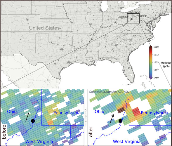 Image:
Data from the Copernicus Sentinel-5P satellite revealed that an explosion in a natural gas well in Ohio in February 2018 released more than 50 000 tons of methane into the atmosphere. The blowout leaked more of this potent greenhouse gas in 20 days than the majority of many European nations do in a year from their oil and gas industries.
Data from the Copernicus Sentinel-5P’s Tropomi instrument revealed that 120 tons of methane were emitted per hour due to the blowout. The findings were published in a study yesterday in the Proceedings of the National Academy of Sciences, and reveals the importance of using satellite data to detect and quantify pollutants such as methane.
The location of the explosion is marked by a black dot in the image, and shows the methane emissions before and after the blowout. The black arrow indicates the wind direction and the direction of the methane plume.
Claus Zehner, ESA’s Copernicus Sentinel-5P mission manager, comments, “These Sentinel-5P measurements show that satellites can measure the concentrations of greenhouse gases emitted by a point source. The satellite’s capabilities will be further exploited with the upcoming Copernicus Carbon Dioxide Monitoring mission.”
While carbon dioxide is more abundant in the atmosphere and therefore more commonly associated with global warming, methane is about 30 times more potent as a heat-trapping gas. It usually enters the atmosphere mainly from the fossil fuel industry, landfill sites, livestock farming, rice agriculture and wetlands – but can also be released during oil and gas extraction.
Sentinel-5P, with its state-of-the-art instrument Tropomi, can also map other pollutants such as nitrogen dioxide, carbon monoxide, sulphur dioxide and aerosols – all of which affect the air we breathe and our climate.
Methane leak visible from space
17.12.2019 16:55 ESA Observing the Earth
Image:
Data from the Copernicus Sentinel-5P satellite revealed that an explosion in a natural gas well in Ohio in February 2018 released more than 50 000 tons of methane into the atmosphere. The blowout leaked more of this potent greenhouse gas in 20 days than the majority of many European nations do in a year from their oil and gas industries.
The findings were published in a study yesterday in the Proceedings of the National Academy of Sciences, and the study reveals the importance of using satellite data to detect and quantify pollutants such as methane. Data from the Copernicus Sentinel-5P’s Tropomi instrument revealed that 120 tons of methane were emitted per hour due to the blowout.
The location of the explosion is marked by a black dot in the image, and shows the methane emissions before and after the blowout. The black arrow indicates the wind direction and the direction of the methane plume.
Claus Zehner, ESA’s Copernicus Sentinel-5P mission manager, comments, “These Sentinel-5P measurements show that satellites can measure the concentrations of greenhouse gases emitted by a point source. The satellite’s capabilities will be further exploited with the upcoming Copernicus Carbon Dioxide Monitoring mission.”
While carbon dioxide is more abundant in the atmosphere and therefore more commonly associated with global warming, methane is about 30 times more potent as a heat-trapping gas. It usually enters the atmosphere mainly from the fossil fuel industry, landfill sites, livestock farming, rice agriculture and wetlands – but can also be released during oil and gas extraction.
Sentinel-5P, with its state-of-the-art instrument Tropomi, can also map other pollutants such as nitrogen dioxide, carbon monoxide, sulphur dioxide and aerosols – all of which affect the air we breathe and our climate.
Simulyze Selected as a Winner in the 2019 "NVTC Tech 100" Awards for Second Consecutive Year
17.12.2019 16:46 GISCafe.com Webcasts-Webinars Simulyze recognized as a leading provider of operational intelligence technology and applications for the region by the Northern Virginia Technology …NICB Uses GIC Imagery To Uncover Disaster Fraud Case In Marshalltown, Iowa
17.12.2019 16:46 GISCafe.com Webcasts-Webinars DES PLAINES, Ill., Dec. 17, 2019 — (PRNewswire) — The National Insurance Crime Bureau (NICB) released a video today detailing how …Rand McNally Launches Advanced Truck Tablet with All-New Navigation 2.0
17.12.2019 16:46 GISCafe.com Webcasts-Webinars The TND™ Tablet 85 also features a directional dash cam and stronger magnetic mountCHICAGO, Dec. 17, 2019 — (PRNewswire) — Rand …
Inaugural European Aerial Survey Summit Attracts Worldwide Audience
17.12.2019 16:44 GISCafe.com Webcasts-Webinars Brussels, 17 December 2019 - Delegates from around the world flocked to the first European Association of Aerial Surveying Industries (EAASI) Summit. …Silvestr 2019
17.12.2019 13:01 ČÚZK - předpisy a opatření Katastrální úřad pro Moravskoslezský kraj - Katastrální pracoviště Karviná zveřejnil novou aktualitu: Vážení klienti,z provozních důvodů bude možno dne 31.12.2019 hradit správní poplatky v hotovosti pouze do 10:00 hodin.
Od 10:00 do 15:00 hodin bude možno platit správní poplatek platební kartou, kolkovou známkou nebo převodem z účtu, na základě podkladu pro platbu, který vám vystaví zaměstnanec podatelny.
Děkujeme za pochopení.
Silvestr_2019
17.12.2019 13:01 ČÚZK /Urady/Katastralni-urady/Katastralni-urady/Katastralni-urad-pro-Moravskoslezsky-kraj/Katastralni-pracoviste/KP-Karvina/O-uradu/Aktuality/Silvestr_2019Silvestr 2019
17.12.2019 13:01 ČÚZK /Urady/Katastralni-urady/Katastralni-urady/Katastralni-urad-pro-Moravskoslezsky-kraj/Katastralni-pracoviste/KP-Karvina/O-uradu/Aktuality/Silvestr_2019Silvestr 2019
17.12.2019 13:01 ČÚZK - předpisy a opatření Katastrální úřad pro Moravskoslezský kraj - Katastrální pracoviště Karviná zveřejnil novou aktualitu: Vážení klienti,z provozních důvodů bude možno dne 31.12.2019 hradit správní poplatky v hotovosti pouze do 10:00 hodin.
Od 10:00 do 15:00 hodin bude možno platit správní poplatek platební kartou, kolkovou známkou nebo převodem z účtu, na základě podkladu pro platbu, který vám vystaví zaměstnanec podatelny.
Děkujeme za pochopení.
Silvestr_2019
17.12.2019 13:01 ČÚZK - předpisy a opatření Český úřad zeměměřický a katastrální - Katastrální pracoviště Karviná zveřejnil novou aktualitu: Vážení klienti,Katastrální úřad pro Moravskoslezský kraj, Katastrální pracoviště Karviná Vás informuje, že z provozních důvodů, vzhledem k upravené pracovní době České pošty, bude možno dne 31. 12. 2019 hradit veškeré poplatky spojené s činností Katastrálního pracoviště Karviná v hotovosti pouze do 10:00 hodin.
Od 10:00 do 15:00 hodin bude možno poplatky hradit platební kartou, kolkovou známkou nebo převodem z účtu na základě podkladu pro platbu, který vám vystaví zaměstnanec podatelny.
Děkujeme Vám za pochopení.
MyGalileoApp – an ecosystem of innovation
17.12.2019 12:04 European GNSS Agency
The MyGalileoApp competition has contributed to the creation of an ecosystem that helps start-ups and other innovators to build innovative applications and grow while enabling both private and public investors to find and invest in projects of interest to them. At the MyGalileoApp finals, which took place at the European GNSS Agency’s (GSA) Prague headquarters at the start of November, start-ups heard about some of the key elements that they will need to succeed in a highly-competitive marketplace.
Galileo has been available to users around the globe since the launch of initial services back in December 2016 and the challenge generally, and for the MyGalileoApp competition specifically, is to make use of the Galileo services to develop systems and applications and to drive innovation based on the technology that Galileo makes available. The competition took nine months in total, during which the competitors progressed from the idea stage to creating a working app with 100% functionality.
Engines of innovation
Francesco Perticarari from Silicon Roundabout, who was a mentor at this year’s competition, noted that the approach of the GSA has been to leverage start-ups as engines of innovation. “The GSA did not just set up a competition to award money to successful developers, it set out to create an ecosystem of tech innovators, from start-ups to mentors and investors and the GSA itself, which also provides support,” he said, adding that the power of the MyGalileoApp competition is the ecosystem it creates that enables start-ups to deliver.
“Whether or not you win a prize today, this is not the end of the story. The connections you have made with mentors, investors and other start-ups are what you should really treasure,” he told the finalists in this year’s competition.
Watch this: Meet Argeo: #MyGalileoApp Competition Winner
Another mentor, Piotr Bucki from Bucki PRO, outlined some of the forces that can drive a start-up forward, including social demographics in the form of a trend that an app can follow. It is also possible to ride a regulatory wave. “If rules from the European Commission or some other authority call for improvements in a service, then companies have no choice but to up their game, he said.
Growth mind-set
“In addition to timing, financing, strategy and riding the aforementioned waves, one more thing that makes start-ups successful is having a growth mind-set. A growth mind-set is the opposite of a fixed mind-set, in which intelligence is static, while in a growth mind-set intelligence and skills can be developed and iterated,” Bucki said.
Maaike Dokter from Xablu noted that location services can improve our quality of life, and that this was true for all of the sectors addressed by the MyGalileoApp finalists’ apps. As a designer with a focus on healthcare, she outlined how location-based services can improve things in this industry by optimising processes and reducing admin, allowing providers to focus on healthcare provision and reducing the amount of time a person has to spend in hospital.
“By increasing outdoor and indoor accuracy, we can take advantage of these opportunities. The MyGalileoApp competitors are finding solutions in which Galileo plays an important role, turning ideas into reality,” she said.
Ensuring sustainability
At a panel discussion held later in the day, start-ups heard from investors about the key qualities that would ensure their sustainability. Marketa Filipenska, International Funding Specialist at the South Moravian Innovation Centre (JIC) said that, in addition to mentoring, complementary services are also important, closely linked to the ecosystem in the region.
Read this: EGNOS service for payment and liability-critical road applications
“We connect venture capital funds, business angels, universities, local stakeholders and corporates - all of these meet with our start-ups and clients to identify opportunities on the market. Investor matching is important, not only to make the business sustainable, but to scale up the company,” she said.
Marta Krywanis-Brzostowska, Head of Downstream R&D in the GSA Market Development Department, noted that when reviewing projects for funding, one thing at the forefront of the GSA’s mind is that it does not want another prototype to put on the shelf.
“We always highlight that it is important to have a link between the proposed solution and needs on the market. Knowledge of the market is critical, so we ask applicants to include a business plan along with their proposals,” she said, adding that an important tool in understanding the market is the GSA’s GNSS Market Report.
“To be sustainable, you have to follow trends, be creative, understand the technology, be enthusiastic about what you are doing and be open to any support,” she said.
Thanks to MyGalileoApp, the GSA has built a network where business partners, public players and investors can connect with start-ups and young innovators, thereby contributing to the development of innovative applications leveraging the advantages of Galileo.
Media note: This feature can be republished without charge provided the European GNSS Agency (GSA) is acknowledged as the source at the top or the bottom of the story. You must request permission before you use any of the photographs on the site. If you republish, we would be grateful if you could link back to the GSA website (http://www.gsa.europa.eu).
Vedení katastrální mapy v oddělení aktualizace KN
17.12.2019 11:43 ČÚZK - volná místa Katastrální úřad pro Zlínský kraj Katastrální pracoviště Vsetín vypisuje výběrové řízení na místo Vedení katastrální mapy v oddělení aktualizace KNVedení katastrální mapy v oddělení aktualizace KN
17.12.2019 11:43 ČÚZK - předpisy a opatření Katastrální úřad pro Zlínský kraj Katastrální pracoviště Vsetínvypisuje výběrové řízení na místo
Vedení katastrální mapy v oddělení aktualizace KN
Vedení katastrální mapy v oddělení aktualizace KN
17.12.2019 11:43 ČÚZK /Urady/Katastralni-urady/Katastralni-urady/Katastralni-urad-pro-Zlinsky-kraj/Uredni-deska/Oznameni-a-jina-uredni-sdeleni/Volna-mista/DMS/Vedeni-katastralni-mapy-v-oddeleni-aktualizace-KNSilvestr_2019
17.12.2019 11:19 ČÚZK - předpisy a opatření Katastrální úřad pro Moravskoslezský kraj - Katastrální pracoviště Ostrava zveřejnil novou aktualitu: Vážení klienti,z provozních důvodů bude možno dne 31.12.2019 hradit poplatky v hotovosti pouze do 11 hodin.
Od 11:00-15:00 hodin bude možno platit poplatek platební kartou, kolkovou známkou nebo převodem z účtu, na základě podkladu pro platbu, který vám vystaví zaměstnanec podatelny.
Děkujeme za pochopení.
Silvestr 2019
17.12.2019 11:19 ČÚZK - předpisy a opatření Katastrální úřad pro Moravskoslezský kraj - Katastrální pracoviště Ostrava zveřejnil novou aktualitu: Vážení klienti,z provozních důvodů bude možno dne 31.12.2019 hradit správní poplatky v hotovosti pouze do 11:00 hodin.
Od 11:00 do 15:00 hodin bude možno platit správní poplatek platební kartou, kolkovou známkou nebo převodem z účtu, na základě podkladu pro platbu, který vám vystaví zaměstnanec podatelny.
Děkujeme za pochopení.
Silvestr 2019
17.12.2019 11:19 ČÚZK /Urady/Katastralni-urady/Katastralni-urady/Katastralni-urad-pro-Moravskoslezsky-kraj/Katastralni-pracoviste/KP-Ostrava/O-uradu/Aktuality/Silvestr_2019Silvestr_2019
17.12.2019 11:19 ČÚZK /Urady/Katastralni-urady/Katastralni-urady/Katastralni-urad-pro-Moravskoslezsky-kraj/Katastralni-pracoviste/KP-Ostrava/O-uradu/Aktuality/Silvestr_2019Galileo Masters 2019: Something special in the Air in Helsinki?
17.12.2019 11:11 European GNSS Agency
Once again, the Galileo Masters – and its sister award programme the Copernicus Masters – was the glittering highlight of EU Space Week 2019 that took place in Helsinki on 3 to 5 December. In its 15th year the Galileo Masters continues to attract the attention of some of the brightest and best minds. Topics submitted to the competition this year ranged through digitisation, big data, the sharing economy and artificial intelligence (AI), amongst others, but all with a common theme: the use of European Global Navigation Satellite Systems (EGNSS) Galileo and/or EGNOS to benefit society.
The 2019 Galileo Masters attracted some 203 participants reaching entrepreneurs from over 41 countries in Europe and around the world. Since its inception in 2004 the competition has seen a cumulative participation by just under 12,000 individuals submitting 4,587 individual business cases.
In addition to the overall Galileo Masters winner and regional awards, a range of special prizes are also given, including ‘Idea of the Year’ and ‘Start-up of the Year’ and a new prize for 2019 responding to an emerging trend: The Galileo-Copernicus Synergy Challenge.
Special prizes
The Gala event took place at the Helsinki Congress Paasitorni centre in central Helsinki on the evening of 4 December. In all, some 31 awards were handed out on the night under the Galileo Masters categories. Master of ceremonies, Bavarian broadcaster and celebrity Claus Kruesken, described the Masters awards ceremony as the “festive highlight of EU Space Week.”
Read this: Performance Cockpit takes overall prize at Galileo Masters 2019
This year’s new prize, the GSA Galileo-Copernicus Synergy Challenge was presented by GSA Executive Director Carlo des Dorides. Commenting on the event, he highlighted the links that the competition inspired between the GSA and the space applications community by “providing the GSA with a first-hand experience of emerging needs and solutions.” The first ever winner of the synergy prize was the Xylene concept from Giuseppe Benenati and his team. Read more here.
Other Galileo special prizes this year included the DLR Artificial Intelligence Navigation Challenge awarded to Pieter Bastiaan Ober of INTEGRICOM for a proposal to analyse the Galileo Signal in Space using AI. The BMVI PRS Applications Challenge was presented to Brandon Bradford of tissEU for his Odin’s Eye idea – a Galileo-enabled PRS tactical drone – that was also the winner of the Bavaria regional Challenge prize.
The University Challenge was announced by Paul Bhatia from the University of Nottingham with the winner, Freewheel – a platform that allows people with reduced mobility to increase their accessibility and inclusion – awarded to Lotfi Massarweh, Deimos Engenharia and their Elecnor team.
The SAWCER concept won the GNSS Living Lab Prize with an idea inspired by a move to a new city, Barcelona, for winner Adrienne Fanning. Her app makes local shops as easy to search as online stores by creating and sharing crowdsourced, geo-localised catalogues.
The internet of Things (IoT) is building to be one of Galileo’s largest markets for applications and the Galileo 5G IoT Challenge award was presented to another idea to help inclusivity by making outdoor sports more accessible to blind or partially sighted people: the WAIBRO belt developed by Katrina Sedlackova and her team at WAIBRO sports.
New ideas and accelerators
Fiammetta Diani, Deputy Head of Market Development at the GSA presented the Idea of the Year and Start-up of the Year prizes; both of which target entrepreneurship. Idea of the Year went to the CX-GEODRONE project and a joint team from the Universities of Vigo and Oviedo, who also won the Galicia regional prize, for a radar-based drone payload that promised the inspection of underground utilities infrastructure without the need to dig up the road.
And this: uMaze takes Accuracy Matters prize in Galileo Innovation Challenge
The Start-up of the Year is awarded to a project that is already being implemented in a start-up that is not older than three years and this year was awarded to PODIS - Post Distress Signal. The winning team led by Andreas Alamanos also won the Greek regional prize for this IoT solution-as-a-service concept for automatic crash notification system.
The prestigious EGNSS Accelerator Winners were announced by Pierre Delsaux, Deputy Director-General for Internal Market, Industry, Entrepreneurship and SMEs at the European Commission. Three winners were announced for the valuable incubation prize. First up was MEDeus, aka the drone doctors, represented by Hammad Jeilani and his UK regional winning team that is looking to improve the efficiency of delivering healthcare supplies using drones.
Another double winner was second: Dronetag also won the Czech regional prize for Lukaz Brchl. The Dronetag concept will provide real-time identification for UAVs by leveraging Galileo and IoT technologies.
The third Incubation winner was in fact a triple success for the German Tocsen GmbH team. Tocsen won the Baden-Wurttemberg regional prize, took this Incubation Accelerator win and was on stage again as the single winner of the EGNSS crowdfunding campaign accelerator! Tocsen is a smart crash detection and automatic emergency call system designed to be incorporated in cyclists’ crash helmets.
Media note: This feature can be republished without charge provided the European GNSS Agency (GSA) is acknowledged as the source at the top or the bottom of the story. You must request permission before you use any of the photographs on the site. If you republish, we would be grateful if you could link back to the GSA website (http://www.gsa.europa.eu).
Galileo Masters 2019: Something special in the Air in Helsinki?
17.12.2019 11:11 European GNSS AgencyOnce again, the Galileo Masters – and its sister award programme the Copernicus Masters – was the glittering highlight of EU Space Week 2019 that took place in Helsinki on 3 to 5 December. In its 15th year the Galileo Masters continues to attract the attention of some of the brightest and best minds. Topics submitted to the competition this year ranged through digitisation, big data, the sharing economy and artificial intelligence (AI), amongst others, but all with a common theme: the use of European Global Navigation Satellite Systems (EGNSS) Galileo and/or EGNOS to benefit society.
The 2019 Galileo Masters attracted some 203 participants reaching entrepreneurs from over 41 countries in Europe and around the world. Since its inception in 2004 the competition has seen a cumulative participation by just under 12,000 individuals submitting 4,587 individual business cases.
In addition to the overall Galileo Masters winner and regional awards, a range of special prizes are also given, including ‘Idea of the Year’ and ‘Start-up of the Year’ and a new prize for 2019 responding to an emerging trend: The Galileo-Copernicus Synergy Challenge.
Special prizes
The Gala event took place at the Helsinki Congress Paasitorni centre in central Helsinki on the evening of 4 December. In all, some 31 awards were handed out on the night under the Galileo Masters categories. Master of ceremonies, Bavarian broadcaster and celebrity Claus Kruesken, described the Masters awards ceremony as the “festive highlight of EU Space Week.”
Read this: Performance Cockpit takes overall prize at Galileo Masters 2019
This year’s new prize, the GSA Galileo-Copernicus Synergy Challenge was presented by GSA Executive Director Carlo des Dorides. Commenting on the event, he highlighted the links that the competition inspired between the GSA and the space applications community by “providing the GSA with a first-hand experience of emerging needs and solutions.” The first ever winner of the synergy prize was the Xylene concept from Giuseppe Benenati and his team. Read more here.
Other Galileo special prizes this year included the DLR Artificial Intelligence Navigation Challenge awarded to Pieter Bastiaan Ober of INTEGRICOM for a proposal to analyse the Galileo Signal in Space using AI. The BMVI PRS Applications Challenge was presented to Brandon Bradford of tissEU for his Odin’s Eye idea – a Galileo-enabled PRS tactical drone – that was also the winner of the Bavaria regional Challenge prize.
The University Challenge was announced by Paul Bhatia from the University of Nottingham with the winner, Freewheel – a platform that allows people with reduced mobility to increase their accessibility and inclusion – awarded to Lotfi Massarweh, Deimos Engenharia and their Elecnor team.
The SAWCER concept won the GNSS Living Lab Prize with an idea inspired by a move to a new city, Barcelona, for winner Adrienne Fanning. Her app makes local shops as easy to search as online stores by creating and sharing crowdsourced, geo-localised catalogues.
The internet of Things (IoT) is building to be one of Galileo’s largest markets for applications and the Galileo 5G IoT Challenge award was presented to another idea to help inclusivity by making outdoor sports more accessible to blind or partially sighted people: the WAIBRO belt developed by Katrina Sedlackova and her team at WAIBRO sports.
New ideas and accelerators
Fiammetta Diani, Head of Market Development at the GSA presented the Idea of the Year and Start-up of the Year prizes; both of which target entrepreneurship. Idea of the Year went to the CX-GEODRONE project and a joint team from the Universities of Vigo and Oviedo, who also won the Galicia regional prize, for a radar-based drone payload that promised the inspection of underground utilities infrastructure without the need to dig up the road.
And this: uMaze takes Accuracy Matters prize in Galileo Innovation Challenge
The Start-up of the Year is awarded to a project that is already being implemented in a start-up that is not older than three years and this year was awarded to PODIS - Post Distress Signal. The winning team led by Andreas Alamanos also won the Greek regional prize for this IoT solution-as-a-service concept for automatic crash notification system.
The prestigious EGNSS Accelerator Winners were announced by Pierre Delsaux, Deputy Director-General for Internal Market, Industry, Entrepreneurship and SMEs at the European Commission. Three winners were announced for the valuable incubation prize. First up was MEDeus, aka the drone doctors, represented by Hammad Jeilani and his UK regional winning team that is looking to improve the efficiency of delivering healthcare supplies using drones.
Another double winner was second: Dronetag also won the Czech regional prize for Lukaz Brchl. The Dronetag concept will provide real-time identification for UAVs by leveraging Galileo and IoT technologies.
The third Incubation winner was in fact a triple success for the German Tocsen GmbH team. Tocsen won the Baden-Wurttemberg regional prize, took this Incubation Accelerator win and was on stage again as the single winner of the EGNSS crowdfunding campaign accelerator! Tocsen is a smart crash detection and automatic emergency call system designed to be incorporated in cyclists’ crash helmets.
Media note: This feature can be republished without charge provided the European GNSS Agency (GSA) is acknowledged as the source at the top or the bottom of the story. You must request permission before you use any of the photographs on the site. If you republish, we would be grateful if you could link back to the GSA website (http://www.gsa.europa.eu).
Capella to Start Commercial Operations in 2020 with Launch of Seven Synthetic Aperture Radar Satellites
17.12.2019 11:08 GISCafe.com Webcasts-Webinars Very high resolution technology and on-demand SAR data drove multi-million dollar deals with the U.S. federal government and diverse industries in …20191217-VŘ Vedoucí oddělení správy RÚIAN
17.12.2019 8:31 ČÚZK - předpisy a opatření Český úřad zeměměřický a katastrální zveřejnil novou aktualitu: Oznámení o vyhlášení výběrového řízení na obsazení služebního místa Vedoucí oddělení správy RÚIAN.20191217-VŘ Vedoucí oddělení správy RÚIAN
17.12.2019 8:31 ČÚZK /Aktuality-resort/2019/20191217-VR-Vedouci-oddeleni-spravy-RUIANVedoucí oddělení správy RÚIAN
17.12.2019 8:21 ČÚZK - předpisy a opatření Český úřad zeměměřický a katastrálnívypisuje výběrové řízení na místo
Vedoucí oddělení správy RÚIAN
Vedoucí oddělení správy RÚIAN
17.12.2019 8:21 ČÚZK - volná místa Český úřad zeměměřický a katastrální vypisuje výběrové řízení na místo Vedoucí oddělení správy RÚIANVedoucí oddělení správy RÚIAN
17.12.2019 8:21 ČÚZK /Urady/Cesky-urad-zememericky-a-katastralni/Uredni-deska/Oznameni-a-jina-uredni-sdeleni/Volna-mista/DMS/Vedouci-oddeleni-spravy-RUIAN20191217-VŘ Vedoucí oddělení správy DMVS
17.12.2019 8:13 ČÚZK /Aktuality-resort/2019/20191217-VR-Vedouci-oddeleni-spravy-DMVS20191217-VŘ Vedoucí oddělení správy DMVS
17.12.2019 8:13 ČÚZK - předpisy a opatření Český úřad zeměměřický a katastrální zveřejnil novou aktualitu: Oznámení o vyhlášení výběrového řízení na obsazení služebního místa Vedoucí oddělení správy DMVS.Vánoční večírek 2019 v Jeremi
17.12.2019 8:06 Hrdlička Letošní Vánoční večírek se konal ve sportovní hale Jeremi..HRDLIČKA spol. s r.o. - Vánoční večírek 2019 v Jeremi
17.12.2019 8:06 Hrdlička Letošní Vánoční večírek se konal ve sportovní hale Jeremi..Vedoucí oddělení správy DMVS
17.12.2019 8:04 ČÚZK - volná místa Český úřad zeměměřický a katastrální vypisuje výběrové řízení na místo Vedoucí oddělení správy DMVSVedoucí oddělení správy DMVS
17.12.2019 8:04 ČÚZK /Urady/Cesky-urad-zememericky-a-katastralni/Uredni-deska/Oznameni-a-jina-uredni-sdeleni/Volna-mista/DMS/Vedouci-oddeleni-spravy-DMVSVedoucí oddělení správy DMVS
17.12.2019 8:04 ČÚZK - předpisy a opatření Český úřad zeměměřický a katastrálnívypisuje výběrové řízení na místo
Vedoucí oddělení správy DMVS
revize v k.ú. Kostelec nad Ohří
17.12.2019 6:37 ČÚZK /Urady/Katastralni-urady/Katastralni-urady/Katastralni-urad-pro-Ustecky-kraj/Katastralni-pracoviste/KP-Litomerice/O-uradu/Aktuality/revize-v-k-u-Kostelec-nad-Ohrirevize v k.ú. Kostelec nad Ohří
17.12.2019 6:37 ČÚZK - předpisy a opatření Katastrální úřad pro Ústecký kraj - Katastrální pracoviště Litoměřicezveřejnil novou aktualitu: Vážení klienti, oznamujeme Vám, že od 10.2.2020 - do 30.11.2020 bude probíhat v katastrálním území Kostelec nad ohří obce Budyně nad Ohří revize katastru nemovitostí. Účelem provádění revize je soulad údajů katastru nemovitostí se skutečným stavem v terénu, kdy jsou zjišťovány změny a ověřován dosavadní stav předmětu evidence katastru nemovitostí.
Revize v k.ú. Dolní Týnec
17.12.2019 6:36 ČÚZK /Urady/Katastralni-urady/Katastralni-urady/Katastralni-urad-pro-Ustecky-kraj/Katastralni-pracoviste/KP-Litomerice/O-uradu/Aktuality/Revize-v-k-u-Dolni-TynecRevize v k.ú. Dolní Týnec
17.12.2019 6:36 ČÚZK - předpisy a opatření Katastrální úřad pro Ústecký kraj - Katastrální pracoviště Litoměřicezveřejnil novou aktualitu: Vážení klienti, oznamujeme Vám, že od 20.1.2020 - do 31.7.2020 bude probíhat v katastrálním území Dolní Týnec obce Třebušín revize katastru nemovitostí. Účelem provádění revize je soulad údajů katastru nemovitostí se skutečným stavem v terénu, kdy jsou zjišťovány změny a ověřován dosavadní stav předmětu evidence katastru nemovitostí.
Revize v k.ú. Šepetely
17.12.2019 6:34 ČÚZK - předpisy a opatření Katastrální úřad pro Ústecký kraj - Katastrální pracoviště Litoměřicezveřejnil novou aktualitu: Vážení klienti, oznamujeme Vám, že od 20.1.2020 - do 30.11.2020 bude probíhat v katastrálním území Šepetely obce Třebívlice revize katastru nemovitostí. Účelem provádění revize je soulad údajů katastru nemovitostí se skutečným stavem v terénu, kdy jsou zjišťovány změny a ověřován dosavadní stav předmětu evidence katastru nemovitostí.
Revize v k.ú. Šepetely
17.12.2019 6:34 ČÚZK /Urady/Katastralni-urady/Katastralni-urady/Katastralni-urad-pro-Ustecky-kraj/Katastralni-pracoviste/KP-Litomerice/O-uradu/Aktuality/Revize-v-k-u-SepetelyRevize v k.ú. Staré
17.12.2019 6:32 ČÚZK /Urady/Katastralni-urady/Katastralni-urady/Katastralni-urad-pro-Ustecky-kraj/Katastralni-pracoviste/KP-Litomerice/O-uradu/Aktuality/Revize-v-k-u-StareRevize v k.ú. Staré
17.12.2019 6:32 ČÚZK - předpisy a opatření Katastrální úřad pro Ústecký kraj - Katastrální pracoviště Litoměřicezveřejnil novou aktualitu: Vážení klienti, oznamujeme Vám, že od 2.1.2020- do 31.10.2020 bude probíhat v katastrálním území Staré obce Třebívlice revize katastru nemovitostí. Účelem provádění revize je soulad údajů katastru nemovitostí se skutečným stavem v terénu, kdy jsou zjišťovány změny a ověřován dosavadní stav předmětu evidence katastru nemovitostí.
Revize v k.ú. Lukov u Úštěku
17.12.2019 6:31 ČÚZK /Urady/Katastralni-urady/Katastralni-urady/Katastralni-urad-pro-Ustecky-kraj/Katastralni-pracoviste/KP-Litomerice/O-uradu/Aktuality/Revize-v-k-u-Lukov-u-UstekuRevize v k.ú. Lukov u Úštěku
17.12.2019 6:31 ČÚZK - předpisy a opatření Katastrální úřad pro Ústecký kraj - Katastrální pracoviště Litoměřicezveřejnil novou aktualitu: Vážení klienti, oznamujeme Vám, že od 2.1.2020- do 31.10.2020 bude probíhat v katastrálním území Lukov u Úštěku obce Úštěk revize katastru nemovitostí. Účelem provádění revize je soulad údajů katastru nemovitostí se skutečným stavem v terénu, kdy jsou zjišťovány změny a ověřován dosavadní stav předmětu evidence katastru nemovitostí.
Revize v k.ú. Mrsklesy
17.12.2019 6:30 ČÚZK - předpisy a opatření Katastrální úřad pro Ústecký kraj - Katastrální pracoviště Litoměřicezveřejnil novou aktualitu: Vážení klienti, oznamujeme Vám, že od 2.1.2020 - do 30.9.2020 bude probíhat v katastrálním území Mrsklesy obce Třebenice revize katastru nemovitostí. Účelem provádění revize je soulad údajů katastru nemovitostí se skutečným stavem v terénu, kdy jsou zjišťovány změny a ověřován dosavadní stav předmětu evidence katastru nemovitostí.
Revize v k.ú. Mrsklesy
17.12.2019 6:30 ČÚZK /Urady/Katastralni-urady/Katastralni-urady/Katastralni-urad-pro-Ustecky-kraj/Katastralni-pracoviste/KP-Litomerice/O-uradu/Aktuality/Revize-v-k-u-MrsklesyRevize v k.ú. Ostré
17.12.2019 6:29 ČÚZK - předpisy a opatření Katastrální úřad pro Ústecký kraj - Katastrální pracoviště Litoměřicezveřejnil novou aktualitu: Vážení klienti, oznamujeme Vám, že od 23.12.2019 - do 26.6.2020 bude probíhat v katastrálním území Ostré obce Úštěk revize katastru nemovitostí. Účelem provádění revize je soulad údajů katastru nemovitostí se skutečným stavem v terénu, kdy jsou zjišťovány změny a ověřován dosavadní stav předmětu evidence katastru nemovitostí.
Revize v k.ú. Ostré
17.12.2019 6:29 ČÚZK /Urady/Katastralni-urady/Katastralni-urady/Katastralni-urad-pro-Ustecky-kraj/Katastralni-pracoviste/KP-Litomerice/O-uradu/Aktuality/Revize-v-k-u-OstreRevize v k.ú. Siřejovice
17.12.2019 6:27 ČÚZK /Urady/Katastralni-urady/Katastralni-urady/Katastralni-urad-pro-Ustecky-kraj/Katastralni-pracoviste/KP-Litomerice/O-uradu/Aktuality/Revize-v-k-u-SirejoviceRevize v k.ú. Siřejovice
17.12.2019 6:27 ČÚZK - předpisy a opatření Katastrální úřad pro Ústecký kraj - Katastrální pracoviště Litoměřicezveřejnil novou aktualitu: Vážení klienti, oznamujeme Vám, že od 27.11.2019 - do 30.6.2020 bude probíhat v katastrálním území Siřejovice obce Siřejovice revize katastru nemovitostí. Účelem provádění revize je soulad údajů katastru nemovitostí se skutečným stavem v terénu, kdy jsou zjišťovány změny a ověřován dosavadní stav předmětu evidence katastru nemovitostí.
Revize v k.ú. Dobkovičky
17.12.2019 6:26 ČÚZK /Urady/Katastralni-urady/Katastralni-urady/Katastralni-urad-pro-Ustecky-kraj/Katastralni-pracoviste/KP-Litomerice/O-uradu/Aktuality/Revize-v-k-u-DobkovickyRevize v k.ú. Dobkovičky
17.12.2019 6:26 ČÚZK - předpisy a opatření Katastrální úřad pro Ústecký kraj - Katastrální pracoviště Litoměřicezveřejnil novou aktualitu: Vážení klienti, oznamujeme Vám, že od 2.12.2019 - do 30.9.2020 bude probíhat v katastrálním území Dobkovičky obce Velemín revize katastru nemovitostí. Účelem provádění revize je soulad údajů katastru nemovitostí se skutečným stavem v terénu, kdy jsou zjišťovány změny a ověřován dosavadní stav předmětu evidence katastru nemovitostí.
Revize v k.ú. Rašovice u Kalovic
17.12.2019 6:25 ČÚZK /Urady/Katastralni-urady/Katastralni-urady/Katastralni-urad-pro-Ustecky-kraj/Katastralni-pracoviste/KP-Litomerice/O-uradu/Aktuality/Revize-v-k-u-Rasovice-u-KalovicRevize v k.ú. Rašovice u Kalovic
17.12.2019 6:25 ČÚZK - předpisy a opatření Katastrální úřad pro Ústecký kraj - Katastrální pracoviště Litoměřicezveřejnil novou aktualitu: Vážení klienti, oznamujeme Vám, že od 1.12.2019 - do 30.9.2020 bude probíhat v katastrálním území Rašovice u Kalovic obce Úštěk revize katastru nemovitostí. Účelem provádění revize je soulad údajů katastru nemovitostí se skutečným stavem v terénu, kdy jsou zjišťovány změny a ověřován dosavadní stav předmětu evidence katastru nemovitostí.
Státní síť imisního monitoringu (ATOM)
17.12.2019 1:00 Cenia - Katalog metadat ČR - INSPIRE Stahovací služba (ATOM) byla vytvořena na základě dat ČHMÚ a obsahuje vrstvu sítě imisních měřicích stanic (měřicích programů) registrovaných v databázi ISKO v roce 2017.Zóny a aglomerace hodnocení a řízení kvality ovzduší (ATOM)
17.12.2019 1:00 Cenia - Katalog metadat ČR - INSPIRE Stahovací služba (ATOM) pro vrstvu zón a aglomerací hodnocení a řízení kvality ovzduší na území České republiky.Pole koncentrací znečišťujících látek (ATOM)
17.12.2019 1:00 Cenia - Katalog metadat ČR - INSPIRE Stahovací služba (ATOM) byla vytvořena na základě dat ČHMÚ a obsahuje vrstvu koncentrace látek znečišťujících ovzduší v gridu 1x1 km.Katalog knihovny ČGS
17.12.2019 1:00 Cenia - Katalog metadat ČR - INSPIRE Aplikace pro jednotné vyhledávání v katalozích knihoven ČGS. Zpřístupňuje katalogy dokumentů geovědního a environmentálního fondu (monografie, separáty, elektronické zdroje, periodika a analytický soupis článků). Starší publikace a články geovědního fondu jsou průběžně doplňovány. Fond environmentální literatury je evidován v knihovním systému kompletně.Pluxity Launches PLUG Kiosk for Comprehensive Spatial Information Service
16.12.2019 17:05 GISCafe.com Webcasts-Webinars - It provides convenience service tailored for mobility handicapped peopleSEOUL, South Korea — (BUSINESS WIRE) — December 15, 2019 …
Cognata Selected by Innoviz to Test and Validate LiDAR Sensor Suite
16.12.2019 17:05 GISCafe.com Webcasts-Webinars The Simulation Platform Replicates How LiDAR Technology Reflects Off of Various Materials, Creating an Unparalleled Virtual Testing …Vrchní referent / rada v oddělení aktualizace PI KN na Katastrálním pracovišti Brno-město
16.12.2019 14:25 ČÚZK - předpisy a opatření Katastrální úřad pro Jihomoravský kraj Katastrální pracoviště Brno-městovypisuje výběrové řízení na místo
Vrchní referent / rada v oddělení aktualizace PI KN na Katastrálním pracovišti Brno-město
Vrchní referent / rada v oddělení aktualizace PI KN na Katastrálním pracovišti Brno-město
16.12.2019 14:25 ČÚZK - volná místa Katastrální úřad pro Jihomoravský kraj Katastrální pracoviště Brno-město vypisuje výběrové řízení na místo Vrchní referent / rada v oddělení aktualizace PI KN na Katastrálním pracovišti Brno-městoVrchní referent / rada v oddělení aktualizace PI KN na Katastrálním pracovišti Brno-město
16.12.2019 14:25 ČÚZK /Urady/Katastralni-urady/Katastralni-urady/Katastralni-urad-pro-Jihomoravsky-kraj/Uredni-deska/Oznameni-a-jina-uredni-sdeleni/Volna-mista/DMS/Vrchni-referent-rada-v-oddeleni-aktualizace-PI-KRada / odborný rada v oddělení právním č. 1 na Katastrálním pracovišti Brno-město
16.12.2019 14:18 ČÚZK /Urady/Katastralni-urady/Katastralni-urady/Katastralni-urad-pro-Jihomoravsky-kraj/Uredni-deska/Oznameni-a-jina-uredni-sdeleni/Volna-mista/DMS/Rada-odborny-rada-v-oddeleni-pravnim-c-1-na-KatRada / odborný rada v oddělení právním č. 1 na Katastrálním pracovišti Brno-město
16.12.2019 14:18 ČÚZK - volná místa Katastrální úřad pro Jihomoravský kraj Katastrální pracoviště Brno-město vypisuje výběrové řízení na místo Rada / odborný rada v oddělení právním č. 1 na Katastrálním pracovišti Brno-městoRada / odborný rada v oddělení právním č. 1 na Katastrálním pracovišti Brno-město
16.12.2019 14:18 ČÚZK - předpisy a opatření Katastrální úřad pro Jihomoravský kraj Katastrální pracoviště Brno-městovypisuje výběrové řízení na místo
Rada / odborný rada v oddělení právním č. 1 na Katastrálním pracovišti Brno-město
Shedding light in the dark: radar satellites lead the way
16.12.2019 12:25 ESA Observing the Earth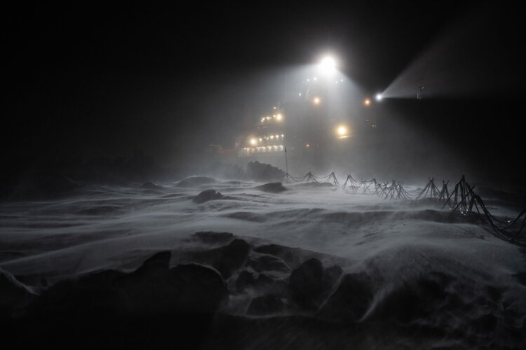
Spare a thought this Christmas for researchers hunkered down on their Polarstern icebreaker, adrift in the frozen Arctic Ocean. Subjected to temperatures as low as –45°C and the perpetual darkness of the polar winter, they are willing participants in MOSAiC – the world’s largest and longest polar research expedition. Despite the darkness, however, the researchers and crew remain aware of what is happening close by. How? With the help of radar imaging satellites.
VZ: Komplexní pozemkové úpravy za téměř 5 milionů korun
16.12.2019 10:01 ZeměměřičStátní pozemkový úřad oznámil veřejnou zakázku na komplexní pozemkové úpravy v k. ú. Chvalčov a části k. ú. Chvalčova Lhota. Předmětem plnění nadlimitní veřejné zakázky na služby je zpracování návrhu komplexních pozemkových úprav v katastrálním území Chvalčov a části k. ú. Chvalčova Lhota včetně nezbytných geodetických prací v třídě přesnosti určené pro obnovu katastru nemovitostí vyhláškou č. 357/2013 Sb. a vytyčení a označení […]
The post VZ: Komplexní pozemkové úpravy za téměř 5 milionů korun appeared first on Zeměměřič.
Úprava úředních hodin ZKI v Brně v prosinci 2019
16.12.2019 9:25 ČÚZK /Urady/Zememericke-a-katastralni-inspektoraty/Zememericke-a-katastralni-inspektoraty/Zememericky-a-katastralni-inspektorat-v-Brne/O-uradu/Aktuality/Uprava-urednich-hodin-ZKI-v-Brne-v-prosinci-2019Úprava úředních hodin ZKI v Brně v prosinci 2019
16.12.2019 9:25 ČÚZK - předpisy a opatření Český úřad zeměměřický a katastrální zveřejnil novou aktualitu: Vážení klienti,úřední hodiny na Zeměměřickém a katastrálním inspektorátu v Brně budou v prosinci 2019 upraveny z provozních důvodů následovně:
pondělí 23. 12. 2019: 7,00 - 13,00 hod.
pondělí 30. 12. 2019: 7,00 -13,00 hod.
úterý 31. 12. 2019: 7,00 - 12,00 hod.
Děkujeme za pochopení.
Úřední hodiny konec r.2019
16.12.2019 8:59 ČÚZK - předpisy a opatření Zeměměřický a katastrální inspektorát v Pardubicích zveřejnil novou aktualitu: úřední hodiny konec r. 2019 Vážení klienti,úřední hodiny na Zeměměřickém a katastrálním inspektorátu v Pardubicích budou v prosinci 2019 z provozních důvodů upraveny takto:
pondělí 23. 12. 2019
od 8,00 h do 13,00 h
pondělí 30. 12. 2019
od 8,00 h do 13,00 h
úterý 31. 12. 2019
od 8,00 h do 12,00 h.
Děkujeme za pochopení.
Úřední hodiny konec r.2019
16.12.2019 8:59 ČÚZK /Urady/Zememericke-a-katastralni-inspektoraty/Zememericke-a-katastralni-inspektoraty/Zememericky-a-katastralni-inspektorat-v-Pardubicic/O-uradu/Aktuality/Uredni-hodiny-konec-r-2019k.ú. Vlčí u Chlumčan
16.12.2019 8:53 ČÚZK - předpisy a opatření Katastrální úřad pro Ústecký kraj - Katastrální pracoviště Louny zveřejnil novou aktualitu:Dne 16.12.2019 byla vyhlášena platnost obnovy katastrálního operátu novým mapováním v intravilánu katastrálního území Vlčí u Chlumčan.
k.ú. Vlčí u Chlumčan
16.12.2019 8:53 ČÚZK - předpisy a opatření Katastrální úřad pro Ústecký kraj - Katastrální pracoviště Louny zveřejnil novou aktualitu:Dne 16.12.2019 byla vyhlášena platnost obnovy katastrálního operátu novým mapováním v intravilánu katastrálního území Vlčí u Chlumčan.
k.ú. Vlčí u Chlumčan
16.12.2019 8:53 ČÚZK /Urady/Katastralni-urady/Katastralni-urady/Katastralni-urad-pro-Ustecky-kraj/Katastralni-pracoviste/KP-Louny/O-uradu/Aktuality/k-u-Vlci-u-ChlumcanHydrogeologie Ašska a Chebska (Geoplasma-CE)
16.12.2019 1:00 Cenia - Katalog metadat ČR - INSPIRE Hydrogeologická data v oblasti Ašska a Chebska získaná nebo zpracovaná v průběhu řešení projektu Geoplasma-CE v letech 2017 až 2018. Jednotlivé vrstvy zahrnují informace o chemickém složení podzemních vod včetně nadlimitních obsahů některých složek dle vyhlášky č. 252/2004 Sb., o výskytu minerálních vod a výronů CO2, o hydraulických vlastnostech hornin a typu hydrogeologického prostředí. Pro jednotlivé hydrogeologické objekty dokumentované v terénu (např. prameny, pramenní jímky) jsou k dispozici výsledky terénních měření a fotodokumentace.Seminář v Poslanecké sněmovně vyvolal zájem o pozemkové úpravy
15.12.2019 20:29 Asociace podnikatelů v geomatice V průběhu celého roku se vedení APG a skupina pozemkové úpravy snažili o posílení finančních prostředků na pozemkové úpravy. Tento proces cíleně vyvrcholil ke konci roku před projednáváním vládního návrhu zákona o státním rozpočtu ČR na rok 2020, a to uspořádáním odborného semináře v Poslanecké sněmovně, o čemž jsme vás již informovali. Jsme potěšeni, že seminář vyvolal zájem o problematiku pozemkových úprav […]"Smart City Initiatives Using Digital Twins" by Susan Smith
15.12.2019 12:11 GISCafe.com Webcasts-WebinarsAPGEO - SEMINÁŘ V POSLANECKÉ SNĚMOVNĚ VYVOLAL ZÁJEM O POZEMKOVÉ ÚPRAVY
15.12.2019 1:00 Asociace podnikatelů v geomatice V průběhu celého roku se vedení APG a skupina pozemkové úpravy snažili o posílení finančních prostředků na pozemkové ...Výběrové řízení na studijní pobyty v rámci Erasmus+ ICM
15.12.2019 0:00 Geografický ústav MUDo 15. prosince 2019 probíhá výběrové řízení na studijní pobyty v akademickém roce 2020/2021 v rámci programu Erasmus+ ICM (tzv. mimoevropský Erasmus).
Aktuální nabídku univerzit a detailní info k podání přihlášky naleznete na webu https://czs.muni.cz/cs/student-mu/studijni-pobyty/erasmus-icm.
Pozn.: Výběrové řízení na "evropský" Erasmus+ proběhne až v únoru roku 2020.
Výběrové řízení na studijní pobyty
15.12.2019 0:00 Geografický ústav MUDo 15. prosince 2019 probíhá výběrové řízení na studijní pobyty v akademickém roce 2020/2021 na partnerských univerzitách MU.
Více informací naleznete na webu https://czs.muni.cz/cs/student-mu/studijni-pobyty/partnerske-univerzity.
NSGIC Releases Findings From Biennial Geospatial Maturity Assessment Survey
14.12.2019 1:21 GISCafe.com Webcasts-Webinars December 13, 2019National States Geographic Information Council (NSGIC) has released its biennial comprehensive Geospatial Maturity Assessment …
Blue Marble Geographics to introduce new academic lab for processing drone or UAV-collected imagery with live webinar in January
14.12.2019 1:20 GISCafe.com Webcasts-Webinars Hallowell, Maine — December 13, 2019 — Blue Marble Geographics® is hosting a live webinar that will introduce the addition of …Aktuální verze VFP 4.3 (17.6.2019)
13.12.2019 21:52 Asociace poskytovatelů služeb v pozemkových úpravách Přílohy Poslední aktualizace Metodický pokyn pro práci s VFP( DOCX, 442.63 KB) 15.5.2019 Příloha 3 – Režim při předávání dat mezi SPÚ a zpracovatelem( PDF, 373.06 KB) 15.5.2019 Příloha 6 – Technický standard polohopisu( ZIP, 412.75 KB) 15.5.2019 Příloha 1 – Definice struktury výměnného formátu verze 4.3( PDF, 1.67 MB) 28.11.2019 Příloha 2 – Kontrola…Aktuální verze VFP 4.3 (17.6.2019)
13.12.2019 21:52 Asociace poskytovatelů služeb v pozemkových úpravách Přílohy Poslední aktualizace Metodický pokyn pro práci s VFP( DOCX, 442.63 KB) 15.5.2019 Příloha 3 – Režim při předávání dat mezi SPÚ a zpracovatelem( PDF, 373.06 KB) 15.5.2019 Příloha 6 – Technický standard polohopisu( ZIP, 412.75 KB) 15.5.2019 Příloha 1 – Definice struktury výměnného formátu verze 4.3( PDF, 1.67 MB) 28.11.2019 Příloha 2 – Kontrola…Výňatky z Informací OMPÚ č. 1/2019
13.12.2019 21:50 Asociace poskytovatelů služeb v pozemkových úpravách Přílohy Poslední aktualizace Výňatky z Informace OMPÚ č. 1/2019( PDF, 425.36 KB) 26.4.2019Výňatky z Informací OMPÚ č. 1/2019
13.12.2019 21:50 Asociace poskytovatelů služeb v pozemkových úpravách Přílohy Poslední aktualizace Výňatky z Informace OMPÚ č. 1/2019( PDF, 425.36 KB) 26.4.2019Výňatky z Informací OMPÚ č. 3/2018
13.12.2019 21:45 Asociace poskytovatelů služeb v pozemkových úpravách Přílohy Poslední aktualizace Výňatky z Informace OMPÚ č. 3/2018( PDF, 224.65 KB) 18.12.2018Výňatky z Informací OMPÚ č. 3/2018
13.12.2019 21:45 Asociace poskytovatelů služeb v pozemkových úpravách Přílohy Poslední aktualizace Výňatky z Informace OMPÚ č. 3/2018( PDF, 224.65 KB) 18.12.2018Připomínky k novele zákona o pozemkových úpravách
13.12.2019 20:32 Asociace podnikatelů v geomatice Začátkem října 2019 APG předložila Hospodářské komoře podnětné připomínky k novele zákona o pozemkových úpravách. Následně se naši zástupci zúčastnili vypořádací porady, která se konala na Ministerstvu zemědělství, čímž byla završena několikaměsíční práce na tomto materiálu. Rádi bychom tímto poděkovali členům pracovní skupiny pozemkové úpravy, kteří se podíleli na vytvoření pečlivě vypracovaných připomínek, především panu Ing. Tomáši […]WYDOT Contracts with Woolpert to Map Landslide-Prone Areas Along Continental Divide
13.12.2019 20:12 GISCafe.com Webcasts-Webinars The high-resolution lidar data and aerial imagery provided by the firm will be used to analyze and monitor habitually unstable areas and further …Používáte open source software? Čeští OpenGeoLabs pro něj mají profi technickou podporu
13.12.2019 19:28 ZeměměřičFirma OpenGeoLabs oznámila zahájení programu technické podpory otevřeného GIS software jako je QGIS, GRASS GIS, GeoServer, PostGIS a Python pro prostorová data. Podpora zahrnuje běžnou uživatelskou podporu, doporučení pracovních postupů (import dat, nastavení, problémy se spuštěním…), monitoring nových verzí a doporučení aktualizace softwaru, migraci procesů a dat z jiných prostředí do otevřeného software (podle rozsahu a složitosti), řešení technických problémů, […]
The post Používáte open source software? Čeští OpenGeoLabs pro něj mají profi technickou podporu appeared first on Zeměměřič.
Carlson 2020 Update Important Notifications
13.12.2019 17:12 Carlson Software Update Available New Carlson 2020 build is now available for download. User action is required as this update may not download automatically due to the problem in the last update. This build includes a number of fixes to Carlson 2020 and IntelliCAD issues. Please download and install the specific patch for your version of CAD. […]Carlson 2020 Update Important Notifications
13.12.2019 17:12 Carlson Software Update Available: New Carlson 2020 build is now available for download. User action is required as this update may not download automatically due to the problem in the last update. This build includes a number of fixes to Carlson 2020 and IntelliCAD issues. Please download and install the specific patch for your version of CAD. […]GIANO – robust GNSS for critical infrastructure
13.12.2019 15:47 European GNSS Agency
Thales Alenia Space has been awarded a grant under the European GNSS Agency’s (GSA) Fundamental Elements funding mechanism for the development of the GIANO (Galileo-based TIming Receiver for CriticAl INfrastructure Robustness) receiver, which aims to make critical infrastructure more robust against interference, jamming and spoofing.
In an increasingly complex GNSS environment in which there is both unintentional and deliberate disruption of satellite signals, the GSA is funding the development of a timing receiver for professional applications to address the needs of the critical infrastructure user community, mainly energy generation and distribution, telecommunications and financial operators.
Improved resilience
The GIANO receiver will leverage Galileo and EGNOS-driven innovation to improve the resilience of the receiver against interference, jamming and spoofing and increase the accuracy and reliability of the time transfer service. The timing platform prototype to be developed and validated will integrate all the latest innovative technologies, including professional products from Thales Alenia Space, paving the way for future Galileo-based timing receivers that offer improved resilience and accuracy at a reasonable cost.
Read this: GSA funding opportunity: Enhanced GNSS Receiver/User Terminal
“Critical infrastructure operators use GNSS for timing and synchronisation and are an important target segment for GSA Market Development because Galileo can make a difference. By funding the development of the GIANO receiver, the GSA aims to provide technological solutions to this community for robust and reliable timing,” said GSA Head of Market Development Fiammetta Diani.
Towards this goal, outreach activities have been conducted among potential final users in the main commercial target groups to collect and analyse their needs. Then, following the definition and consolidation of stakeholders’ needs and the platform specifications, the project conducted a Preliminary Design Review at the end of November 2019.
Europe-wide cooperation
The two-year project, funded under a GSA grant related to the Development of a Galileo-based timing receiver for critical infrastructures (GSA/GRANT/05/2017), will be coordinated by Thales Alenia Space in Italy, in collaboration with four European partners: Business Integration Partners S.p.A (BIP, Italy), PIKTime Systems (Poland), Space Research Centre of the Polish Academy of Science (SRC PAS, Poland) and DEIMOS (Portugal).
And this: Orolia selected for Galileo resilient time receiver initiative
The project will also benefit from the support of the European Commission’s in-house science service - the Joint Research Centre (JRC) and the Italian National Metrology Institute (INRIM), which will make available its test facilities for verification activities on the developed equipment.
GIANO – robust GNSS for critical infrastructure
13.12.2019 15:47 European GNSS AgencyThales Alenia Space has been awarded a grant under the European GNSS Agency’s (GSA) Fundamental Elements funding mechanism for the development of the GIANO (Galileo-based TIming Receiver for CriticAl INfrastructure Robustness) receiver, which aims to make critical infrastructure more robust against interference, jamming and spoofing.
In an increasingly complex GNSS environment in which there is both unintentional and deliberate disruption of satellite signals, the GSA is funding the development of a timing receiver for professional applications to address the needs of the critical infrastructure user community, mainly energy generation and distribution, telecommunications and financial operators.
Improved resilience
The GIANO receiver will leverage Galileo and EGNOS-driven innovation to improve the resilience of the receiver against interference, jamming and spoofing and increase the accuracy and reliability of the time transfer service. The timing platform prototype to be developed and validated will integrate all the latest innovative technologies, including professional products from Thales Alenia Space, paving the way for future Galileo-based timing receivers that offer improved resilience and accuracy at a reasonable cost.
Read this: GSA funding opportunity: Enhanced GNSS Receiver/User Terminal
“Critical infrastructure operators use GNSS for timing and synchronisation and are an important target segment for GSA Market Development because Galileo can make a difference. By funding the development of the GIANO receiver, the GSA aims to provide technological solutions to this community for robust and reliable timing,” said GSA Head of Market Development Fiammetta Diani.
Towards this goal, outreach activities have been conducted among potential final users in the main commercial target groups to collect and analyse their needs. Then, following the definition and consolidation of stakeholders’ needs and the platform specifications, the project conducted a Preliminary Design Review at the end of November 2019.
Europe-wide cooperation
The two-year project, funded under a GSA grant related to the Development of a Galileo-based timing receiver for critical infrastructures (GSA/GRANT/05/2017), will be coordinated by Thales Alenia Space in Italy, in collaboration with four European partners: Business Integration Partners S.p.A (BIP, Italy), PIKTime Systems (Poland), Space Research Centre of the Polish Academy of Science (SRC PAS, Poland) and DEIMOS (Portugal).
And this: Orolia selected for Galileo resilient time receiver initiative
The project will also benefit from the support of the European Commission’s in-house science service - the Joint Research Centre (JRC) and the Italian National Metrology Institute (INRIM), which will make available its test facilities for verification activities on the developed equipment.
The true impact of space is felt downstream
13.12.2019 15:12 European GNSS Agency
The upstream space market, with its rocket launches and high-tech satellite payloads, may seem at a first glance to be the most exciting segment of the space industry. But when it comes to innovation, job and revenue creation and the provision of services that change people’s lives for the better, the downstream market is where the action is. This was the key message delivered by European GNSS Agency (GSA) Executive Director Carlo des Dorides at the New Space Economy forum in Rome on December 12.
We are living in the Golden Age of GNSS. Space-based technology is driving innovation and supporting service delivery in almost all sectors of the global economy – from agriculture and transport to healthcare and telecoms. Satellites and the location-based services that they enable are transforming the way that we live and work.
Downstream driving the space economy
Delivering a keynote address on GNSS markets, applications and data at the NSE forum, the GSA Executive Director noted that downstream users are directly benefitting from Galileo. “Over 50,000 jobs are supported annually in the downstream GNSS industry,” des Dorides said, adding that European companies account for 27% of the global GNSS market and that this share is set to grow.
“GNSS downstream is driving the space economy. Global revenue generated by the GNSS downstream market is forecast to reach EUR 150 billion in 2019 and increase to EUR 325 billion in 2029,” des Dorides said, citing the latest edition of the GSA GNSS Market Report. “Over 50% of this GNSS revenue comes from added-value services,” he said.
Read this: Europe’s economy is increasingly dependent on space
With the evolution of the GSA into the European Agency for the Space Programme (EUSPA) it will be possible to fully exploit synergies between the EU space programmes to deliver applications and services in a wide range of sectors, from security and emergency response, to urban planning, agriculture and energy and critical infrastructure, des Dorides said.
“With its expanded mandate, the GSA will continue to support entrepreneurship and stimulate the EU downstream market to deliver applications with tangible social benefits, such as improved environmental performance, better transport efficiency and more effective emergency response,” he said.
Driving innovation in transport
One sector in particular in which new possibilities are opening up is road transport, which is a huge GNSS market segment. The road segment is forecast to dominate all other market segments and account for 93.3% of cumulative revenue in 2019-2029. In her keynote at the NSE forum, the GSA’s Head of Market Development Fiammetta Diani spoke about GNSS and the road sector and, in particular, the state of play in autonomous vehicles.
Noting that almost 97% of new vehicles are equipped with GNSS-enabled in-vehicle systems, which provide PNT for a wide range of in-vehicle applications, Diani said that these systems are currently able to support navigation, remote diagnostics and assisted driving. “In the future, IVS will support even more complex applications, including automated driving,” she said.
And this: First Galileo-enabled autonomous vehicle successfully demonstrated
In terms of the state of play with autonomous driving, the GSA’s Head of Market Development said that preparations are currently underway for Level 4. At this level, a highly automated vehicle performs all driving tasks and monitors the environment under limited conditions, but the driver may still be required to intervene. Level 4 is the penultimate stage before full automation at Level 5.
Diani also noted the recent live demonstration of a Galileo-enabled autonomous vehicle. As part of this demonstration, a Renault ZOE electric car fitted with an innovative positioning engine developed by the ESCAPE project was autonomously driven on tracks at the University of Technology and on public roads in Compiègne, France. The EGE leverages Galileo signals and services to provide a core positioning component in autonomous vehicles.
"This successful test of the ESCAPE positioning engine based on Galileo, at automation Level 4, means that we are getting closer to provide the high accurate and reliable absolute positioning that will be needed for full automation,” she said.
More generally, Galileo will support new road safety functions that will become mandatory from 2022, including accident data recording, intelligent speed assistance, lane keeping assistance and vulnerable road user detection.
Media note: This feature can be republished without charge provided the European GNSS Agency (GSA) is acknowledged as the source at the top or the bottom of the story. You must request permission before you use any of the photographs on the site. If you republish, we would be grateful if you could link back to the GSA website (http://www.gsa.europa.eu).
Úklid
13.12.2019 14:24 ČÚZK - volná místa Český úřad zeměměřický a katastrální vypisuje výběrové řízení na místo ÚklidÚklid
13.12.2019 14:24 ČÚZK - předpisy a opatření Český úřad zeměměřický a katastrálnívypisuje výběrové řízení na místo
Úklid
Která knihovna je lepší? Leaflet, OpenLayers nebo MapBox GL? V diskuzi na Hacker News se dozvíte detaily
13.12.2019 14:20 GeoBusiness Začátkem listopadu 2019 byla vydána nová verze knihovny OpenLayers, aktuálně ve verzi 6.1.1. V polovině prosince na to upozornil někdo na Hacker News a hned se rozjela sofistikovaná diskuse, jak kterou knihovnu používat na co. K dispozici v podstatě přicházejí tři hlavní knihovny: Leaflet, OpenLayers a MapBox GL. mourner Leaflet author here! Just wanted […]Autor Leafletu chválí OpenLayers. Diskuse na Hacker News
13.12.2019 14:20 GeoBusiness Začátkem listopadu 2019 byla vydána nová verze knihovny OpenLayers, aktuálně ve verzi 6.1.1. V polovině prosince na to upozornil někdo na Hacker News a hned se rozjela sofistikovaná diskuse, kterou knihovnu používat na co. K dispozici jsou v podstatě tři knihovny: Leaflet, OpenLayers a MapBox GL. mourner 2 days ago [-] Leaflet author here! […]Úřední hodiny a placení poplatků dne 31. 12. 2019
13.12.2019 14:19 ČÚZK /Urady/Katastralni-urady/Katastralni-urady/Katastralni-urad-pro-Liberecky-kraj/Katastralni-pracoviste/KP-Ceska-Lipa/O-uradu/Aktuality/Uredni-hodiny-a-placeni-poplatku-dne-31-12-2019Úřední hodiny a placení poplatků dne 31. 12. 2019
13.12.2019 14:19 ČÚZK - předpisy a opatření Katastrální úřad pro Liberecký kraj - Katastrální pracoviště Česká Lípa zveřejnil novou aktualitu: Vážení klienti,úřední hodiny Katastrálního pracoviště Česká Lípa nebudou dne 31. 12. 2019 zkráceny, tj. budou od 8 - 14:45 hodin.
Platba poplatků (zejména za podání návrhu na vklad) v hotovosti bude v uvedený den možná pouze do 11 hodin.
Od 11 - 14:45 hodin bude možné platit poplatek platební kartou, kolkovou známkou nebo převodem z účtu, na základě podkladu pro platbu, kterou Vám vystaví zaměstnanci podatelny. Důvodem je nutnost zajistit připsání vybraných správních poplatků do státního rozpočtu do konce roku 2019.
Děkujeme za pochopení.
Mega velký přehled knih o programovacích jazycích a algoritmech
13.12.2019 14:03 GeoBusiness Chtěli byste se naučit nějaký skriptovací nebo programovací jazyk? Na Githubu skupina dobrovolníků dává postupně dohromady přehled snad všech volně dostupných návodů, knih a manuálů ke všem myslitelným jazykům a algoritmům. Zdroje jsou navíc roztříděny podle jazyků. Takže pokud byste rádi zbytek svého života a polovinu dalšího chtěli strávit studiem programovacích jazyků, máte na Githubu […]Skladník v ekonomicko - správním oddělení
13.12.2019 13:59 ČÚZK - volná místa Katastrální úřad pro Zlínský kraj kancelář ředitele vypisuje výběrové řízení na místo Skladník v ekonomicko - správním odděleníSkladník v ekonomicko - správním oddělení
13.12.2019 13:59 ČÚZK /Urady/Katastralni-urady/Katastralni-urady/Katastralni-urad-pro-Zlinsky-kraj/Volna-mista/DMS/Skladnik-v-ekonomicko-spravnim-oddeleniSkladník v ekonomicko - správním oddělení
13.12.2019 13:59 ČÚZK - předpisy a opatření Katastrální úřad pro Zlínský kraj kancelář ředitelevypisuje výběrové řízení na místo
Skladník v ekonomicko - správním oddělení
Satnav watching over rugby players
13.12.2019 13:59 ESA Navigation
As France’s top rugby players scrum, run and tackle they are being tracked by more than just TV cameras and the watching eyes of the crowd. Satnav-based tracking devices between their shoulder blades are keeping tabs on their position and performance – and helping to safeguard their health.
Rada / odborný rada právního oddělení
13.12.2019 13:13 ČÚZK - předpisy a opatření Katastrální úřad pro Středočeský kraj - Katastrální pracoviště Praha-východvypisuje výběrové řízení na místo Rada / odborný rada právního oddělení
Rada / odborný rada právního oddělení
Rada / odborný rada právního oddělení
13.12.2019 13:13 ČÚZK /Urady/Katastralni-urady/Katastralni-urady/Katastralni-urad-pro-Stredocesky-kraj/Uredni-deska/Oznameni-a-jina-uredni-sdeleni/Volna-mista/Rada-odborny-rada-pravniho-oddeleniRada / odborný rada právního oddělení
13.12.2019 13:13 ČÚZK - volná místa Katastrální úřad pro Středočeský kraj - Katastrální pracoviště Praha-východ vypisuje výběrové řízení na místo Rada / odborný rada právního odděleníVánoční aktualizace geodetického software KOKEŠ od firmy GEPRO
13.12.2019 12:31 ZeměměřičDo geodetického softwaru KOKEŠ ve verzi 14.50, která byla firmou GEPRO oznámena před vánocemi 2019, programátoři udělali následující aktualizace Geom. plány – do převzetí ze starého nastavení doplněno i převzetí GEPLAN.INI. Geom. plány – Tisk GP: funkce nově předpřipraví název výsledného souboru dle kat. vyhlášky včetně možnosti zadat cílový adresář, přidány volby na tisk formuláře „výpočet […]
The post Vánoční aktualizace geodetického software KOKEŠ od firmy GEPRO appeared first on Zeměměřič.
Novinky ve vánoční verzi systému MISYS 14.50
13.12.2019 12:30 ZeměměřičVývojářská firma GEPRO představila novou verzi svého software MISYS, aktuálně ve verzi 14.50, která obsahuje následující aktualizace a novinky Práce s atributy – atributová tabulka pracuje i nad daty WFS. Práce s atributy – do atributové tabulky přidána funkčnost hromadných operací z textového souboru. Práce s atributy – nová funkce Doplnění dalších informací k parcelnímu číslu identifikací. Úpravy v souvislosti se změnami v poskytování […]
The post Novinky ve vánoční verzi systému MISYS 14.50 appeared first on Zeměměřič.
EU Space Week 2019: Sustainability and Space
13.12.2019 12:13 European GNSS Agency
Helsinki was the cool venue for European Space Week 2019. From 3 to 5 December Europe’s leading space event brought together business leaders, policymakers, international experts and the space application user community to gain first-hand insights into the EU’s Space Programmes Copernicus, EGNOS and Galileo. They discussed how space solutions can contribute to a more sustainable future for Europe and the world.
This year’s European Space Week focused on four central themes: how space solutions can help to strengthen the EU’s position as a global leader in climate action; the new space economy for sustainable growth; how to save space for future generations; and space solutions for a sustainable Arctic environment.
Opening the EU Space Week plenary under the banner ‘Sustainable Space, Sustainable Europe, Sustainable Future’ former Finnish President Tarja Halonen highlighted how “Space applications observe own blue planet, enable us to find our way, communicate and connect, more sustainably.”
Christophe Grudler, MEP stated: "Major investments by the EU have enabled progress that no Member State could have achieved on its own.” He highlighted the need to defend and grow the space allocation in the forthcoming European Union budget negotiations. “An ambitious budget will be the only way to ensure Europe's global leadership and strategic autonomy," he concluded.
Pierre Delsaux from the European Commission agreed saying: “We must continue to invest in space.”
Space for climate action
The new European Commission will have a clear focus on climate action, but how can space solutions help? Pierre Delsaux highlighted a future Copernicus mission to monitor CO2 emissions, while GSA Executive Director Carlo des Dorides outlined the contributions of Galileo and EGNOS to improve resource and energy efficiency and sustainable agriculture through more accurate positioning by enabling the maxim: “Doing more with less.”
“At GSA’s core is the development of products and services,” he continued. “We are funding concrete projects delivering solutions to specific questions and organising events such as hackathons to inspire young developers. The limit to projects is human creativity.”
Sustainable space ecosystem
A new economic ecosystem has been created in Europe as more talent and investment see the space sector as a cool place to do business. Pekka Laurila of Iceye, a small satellite company in Finland building a new digital infrastructure to enable real time knowledge of where everything is at all times, acknowledged that their success has been enabled by others. “We are the product of an ecosystem; we are standing on the shoulders of giants including institutions funded by public money plus a high-quality education system,” Laurila said.
Investor Uli Fricke, founder of Triangles, agreed that there was a viable and thriving commercial space market in Europe and “The funding ecosystem from start-up to IPO is the bottleneck for many companies.” The key factor for any young space business was to have a clear business model and value proposition. “Often you need to take the space angle out of the question, when talking to investors,” she added.
Pascal Claudel, Chief Operating Officer at the GSA highlighted the agency’s role in delivering services 24/7 to users and in fostering users across all market sectors. “We can support SMEs in this ecosystem across the whole EU,” he said. “And there is no need to have space experience to work in the space market nowadays.” But there was a need to work together and involve all EU Member States and public and private investors to grow and sustain the market.
Saving Space
Space – especially low Earth orbit – is becoming a congested space noted keynote speaker Professor Minna Palmroth of the University of Helsinki. And more satellites are being launched with a mega trend towards very large fleets of small commercial satellites. Space debris is becoming a priority issue and she also highlighted the lack of knowledge of space weather in the near-Earth environment. “We still do not fully understand the environment that we launch into,” she commented.
But how to clear the debris? Newer satellites will have limited lifetimes and include de-orbiting technology, while older satellites might require third party action. Could there be a market established for deorbiting space debris and is international legislation a way forward or is standardisation the right route? “The sustainable future in space requires every one of us to work together on this topic,” she concluded.
Sustainable Arctic
The final Space Week plenary examined how EU space solutions can protect the arctic environment and support sustainable growth as the climate changes. Jouni Pulliainen, Director of Space & EO, at the Finnish Meteorological Institute saw three main issues where space can help: gaps in monitoring the climatic changes that are happening, improved communications and more accurate navigation information. Session moderator Professor Heidi Kuusniemi of Vaasa University reinforced the growing importance of robust and reliable navigation services in the Arctic.
Improved synergies between space services could help boost their use in the Arctic said Dan Chirondojan, Director at the Commission’s Joint Research Centre that has conducted a study on space solutions and the region. Improved satellite navigation and communication would be needed to enable future remote control and autonomous vessels in the arctic said Karno Kenovuo, Co-founder and CEO of Awake.AI so evolution of EGNSS services in the region was important. Wider coverage of the Galileo Search and Rescue (SAR) service would be very useful due to its enhanced performance.
Mauro Facchini of the European Commission agreed and indicated that the EGNOS Safety of Life service was currently supported to 72 degrees North but may be extended to 75 degrees North soon and could be deployed over the entire arctic by 2030.
Concluding the plenary sessions Finnish Undersecretary of State at the Ministry of Economic Affairs, Katri Kulmuni thanked all participants in EU Space Week 2019 and stated that: “Space activities must be pursued in a sustainable and responsible manner,” but that the week’s debates had shown that “Space is truly a channel for sustainable growth.”
Media note: This feature can be republished without charge provided the European GNSS Agency (GSA) is acknowledged as the source at the top or the bottom of the story. You must request permission before you use any of the photographs on the site. If you republish, we would be grateful if you could link back to the GSA website (http://www.gsa.europa.eu).