


zprávy
zdroje zpráv:20191126-Seznam zeměměřických inženýrů
26.11.2019 10:35 ČÚZK /Aktuality-resort/2019/20191126-Seznam-zememerickych-inzenyruFloods in northern Italy
26.11.2019 10:31 ESA Observing the Earth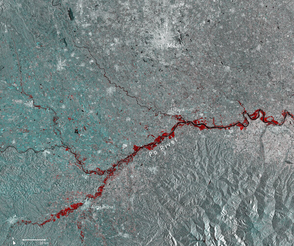 Image:
Torrential downpours have battered many parts of Italy this month, with extreme flooding wreaking havoc across northern Italy. The province of Alessandria is said to be one of the worst-affected areas according to Italian media, with around 200 people evacuated and 600 said to be left stranded.
This multi-temporal image uses two separate images captured by the Copernicus Sentinel-1 mission on 13 November and 25 November. The flooded areas can be seen depicted in red, the Po River in black, and urban areas in white.
Copernicus Sentinel-1’s radar ability to ‘see’ through clouds and rain, and in darkness, makes it particularly useful for monitoring floods. It can even easily differentiate water bodies, highlighting the difference between the Po River in black, and the extent of the flooding in red.
Around 500 people were evacuated further north in the Aosta Valley, where many roads were closed in fear of potential avalanches. Part of a viaduct serving the A6 motorway near Savona, in the northern region of Liguria, was washed away by a mudslide – leaving a 30 m gap in the road.
Images acquired before and after flooding offer immediate information on the extent of inundation and support assessments of property and environmental damage.
Earlier this month, the Copernicus Emergency Mapping Service was activated to help respond to the floods in northeast Italy, where Venice saw record-breaking water levels and the worst flooding in 50 years.
HRDLIČKA spol. s r.o. - Byli jsme součástí studentské soutěže GISáček 2019
26.11.2019 10:26 Hrdlička V březnu proběhl další ročník konference GISáček, který je součástí Sympozia GIS Ostrava.Byli jsme součástí studentské soutěže GISáček 2019
26.11.2019 10:26 Hrdlička V březnu proběhl další ročník konference GISáček, který je součástí Sympozia GIS Ostrava.Omezení provozu 27.11.2019
26.11.2019 9:22 ČÚZK - předpisy a opatření Katastrální úřad pro Vysočinu - Katastrální pracoviště Velké Meziříčí zveřejnil novou aktualitu: Katastrální úřad pro Vysočinu, Katastrální pracoviště Velké Meziříčí oznamuje, že dne 27.11.2019 od 7:30 do 11:30 hodin bude z důvodu výluky elektrické energie omezen provoz.Děkujeme za pochopení.
Omezení provozu 27.11.2019
26.11.2019 9:22 ČÚZK /Urady/Katastralni-urady/Katastralni-urady/Katastralni-urad-pro-Vysocinu/Katastralni-pracoviste/KP-Velke-Mezirici/O-uradu/Aktuality/Omezeni-provozu-27-11-2019Oil spill detection with Synthetic Aperture Radar (SAR)
26.11.2019 9:00 GISCafe.com Webcasts-Webinars November 25, 2019 -- Marine pollution is a great and very troublesome problem and can be directly or indirectly by man made source giving energy or …Leitstelle Tirol Selects Hexagon’s Computer-Aided Dispatch Solution for Statewide Command & Control Center
26.11.2019 5:00 Hexagon Safety & Infrastructure Leitstelle Tirol GmbH, the statewide command and control center for fire, rescue and other emergency response services in the federal state of Tyrol, Austria, has chosen the industry-leading computer-aided dispatch (CAD) solution from Hexagon’s Safety & Infrastructure division to support call-takers and dispatchers and optimize public safety answering point (PSAP) processes.“For more than a decade, Hexagon has supported the efforts of fire and rescue agencies across Austria,” said Bernd Noggler, managing director for Leitstelle Tirol. “We are excited to work closely with them to improve every facet of our operation – from call-taking and emergency handling to reporting and incident analysis.”
As the prime contractor for the project, Hexagon’s Safety & Infrastructure division will integrate the new CAD system with the rescuetrack geospatial platform by Convexis and the voice communications system by Strabag Infrastructure & Safety Solutions. An end-to-end solution with leading-edge spatial search, routing and unit recommendation and alarming functionality will be delivered. This will help to pinpoint an event’s location as quickly as possible, reduce response times and optimize use of the statewide fire and rescue fleet.
“Leitstelle Tirol is internationally known for their innovative use of CAD," said Nick Chorley, director EMEA public safety and security for Hexagon’s Safety & Infrastructure division. “We are honored to contribute to their legacy of providing quality emergency response for citizens and tourists.”
One of the most popular winter sports destinations in the Alps, the state of Tyrol is home to 750,000 citizens and hosts more than 49 million overnight stays each year. To support the needs of both citizens and visitors, Leitstelle Tirol currently receives more than 500,000 emergency calls and responds to over 350,000 incidents annually.
Hexagon’s Safety & Infrastructure division is the global leader in public safety and security, helping to protect 1 in 12 people worldwide. Its public safety and security solutions work to improve the quality, accuracy and availability of critical information – increasing performance and productivity while simultaneously reducing the total cost of ownership for mission-critical IT investments.
HPE Reports Fiscal 2019 Fourth Quarter and Full-Year Results
26.11.2019 1:09 GISCafe.com Webcasts-Webinars Delivers strong profitability and free cash flowQ4 2019 Financial Highlights:
Revenue: $7.2 billion, stable for the last three quarters
Gross …
Leitstelle Tirol Selects Hexagon’s Computer-Aided Dispatch Solution for Statewide Command & Control Center
26.11.2019 1:00 Hexagon Safety & Infrastructure Dispatch system will help reduce response times and bolster public safety answering point (PSAP) command center.Leitstelle Tirol Selects Hexagon’s Computer-Aided Dispatch Solution for Statewide Command & Control Center
26.11.2019 1:00 Hexagon Safety & Infrastructure Dispatch system will help reduce response times and bolster public safety answering point (PSAP) command center.Leitstelle Tirol Selects Hexagon’s Computer-Aided Dispatch Solution for Statewide Command & Control Center
26.11.2019 1:00 Hexagon Safety & InfrastructureDispatch system will help reduce response times and bolster public safety answering point (PSAP) command center.
INSPIRE stahovací služba – Pole koncentrací znečišťujících látek
26.11.2019 1:00 Cenia - Katalog metadat ČR - INSPIRE Koncentrace látek znečišťujících ovzduší v gridu 1x1 km, rok 2017 Imisní limity pro ochranu lidského zdravíSO2 – 4. nejvyšší 24hod. koncentrace SO2 [µg.m-3]PM10 – roční průměrná koncentrace [µg.m-3]PM10 – 36. nejvyšší průměrná 24hod. koncentrace [µg.m-3]PM2.5 – roční průměrná koncentrace [µg.m-3]NO2 – roční průměrná koncentrace [µg.m-3]O3 – 26. nejvyšší maximální denní 8hod. klouzavý průměr koncentrace v průměru za 3 roky, 2015–2017 [µg.m-3]Cd – roční průměrná koncentrace [ng.m-3]As – roční průměrná koncentrace [ng.m-3]Benzo[a]pyren – roční průměrná koncentrace [ng.m-3]Benzen – roční průměrná koncentrace [µg.m-3]Oblasti s překročením imisních limitů bez zahrnutí O3Oblasti s překročením imisních limitů bez zahrnutí Imisní limity pro ochranu ekosystémů a vegetaceO3 – hodnoty expozičního indexu AOT40, průměr za 5 let, 2012–2016 [µg.m-3]NOx – roční průměrná koncentrace [µg.m-3]SO2 – rok a zimní období [µg.m-3]Úřady veřejné správy
26.11.2019 1:00 Cenia - Katalog metadat ČR - INSPIRE Soubor všech orgánů veřejné moci - ústřední orgány státní správy, krajské úřady, obecní úřady všech typů, dále instituce, které vykonávají výkon přenesené působnosti.INSPIRE – Pole koncentrací znečišťujících látek / Air quality model areas
26.11.2019 1:00 Cenia - Katalog metadat ČR - INSPIRE Koncentrace látek znečišťujících ovzduší v gridu 1x1 km, rok 2017 Imisní limity pro ochranu lidského zdravíSO2 – 4. nejvyšší 24hod. koncentrace SO2 [µg.m-3]PM10 – roční průměrná koncentrace [µg.m-3]PM10 – 36. nejvyšší průměrná 24hod. koncentrace [µg.m-3]PM2.5 – roční průměrná koncentrace [µg.m-3]NO2 – roční průměrná koncentrace [µg.m-3]O3 – 26. nejvyšší maximální denní 8hod. klouzavý průměr koncentrace v průměru za 3 roky, 2015–2017 [µg.m-3]Cd – roční průměrná koncentrace [ng.m-3]As – roční průměrná koncentrace [ng.m-3]Benzo[a]pyren – roční průměrná koncentrace [ng.m-3]Benzen – roční průměrná koncentrace [µg.m-3]Oblasti s překročením imisních limitů bez zahrnutí O3Oblasti s překročením imisních limitů bez zahrnutí Imisní limity pro ochranu ekosystémů a vegetaceO3 – hodnoty expozičního indexu AOT40, průměr za 5 let, 2012–2016 [µg.m-3]NOx – roční průměrná koncentrace [µg.m-3]SO2 – rok a zimní období [µg.m-3]Legislativa vyžaduje, aby primárním zdrojem hodnocení byly výsledky stacionárních měření. Naměřené koncentrace mohou být při tvorbě map znečisťujících látek doplněny modelováním a indikativním měřením, aby výsledný odhad poskytoval dostatečné informace o prostorovém rozložení koncentrací znečišťujících látek v ovzduší.V ČR je využíván zejména Eulerovský chemický disperzní model CAMx, doplňkově též Gaussovský model SYMOS a evropský Eulerovský model EMEP. Dále jsou to v případě jednotlivých znečišťujících látek např. nadmořská výška či populační hustota.Leitstelle Tirol Selects Hexagon’s Computer-Aided Dispatch Solution for Statewide Command & Control Center
26.11.2019 1:00 Hexagon Safety & InfrastructureDispatch system will help reduce response times and bolster public safety answering point (PSAP) command center.
INSPIRE – Data o kvalitě ovzduší / Air quality data
26.11.2019 1:00 Cenia - Katalog metadat ČR - INSPIRE Koncentrace naměřené všemi monitorovacími sítěmi jsou ukládány do imisní databáze ISKO. V databázi jsou archivovány údaje již od počátku měření, koncentrace oxidu siřičitého a suspendovaných částic ze staničních sítí ČHMÚ v severních Čechách a v Praze již od roku 1971. S imisními daty jsou do imisní databáze ukládána i doprovodná meteorologická data, která jsou měřena na velké části automatizovaných imisních stanic ČHMÚ a jsou využívána pro hodnocení imisně-meteorologických vztahů. Imisní databáze ISKO zahrnuje kromě výsledků měření ČHMÚ, které zajišťují pracovníci Imisního monitoringu v centru i na pobočkách, i data poskytovaná spolupracujícími institucemi. Jedná se zejména o zdravotní ústavy, ČEZ, a. s., Výzkumný ústav lesního hospodářství a myslivosti, v.v.i., Českou geologickou službu, Hydrobiologický ústav, městské úřady a další přispěvatele. V databázi jsou též zahrnuty informace z příhraničních oblastí Německa a Polska.Legislativní změny platné od 1. 11. 2019
26.11.2019 0:00 Státní pozemkový úřad Legislativní změny platné od 1. 11. 2019 se dotknou zejména zákona o SPÚ a zákona o půděCílem novely zákona o SPÚ je především zakotvit přednost státu při převodu pozemku z rezervy určené pro rozvojové programy státu, pokud souběžně vznesou žádosti o tento pozemek další subjekty. Novela také upraví způsob oceňování majetku, kdy směna či koupě pozemku za účelem vytvoření a zachování potřebného rozsahu a složení rezervy státních pozemků může být realizována nejvýše za cenu obvyklou.
Helios Visions Releases Guide to Flying Drones in Chicago and Illinois
25.11.2019 23:06 GISCafe.com Webcasts-Webinars CHICAGO, Nov. 25, 2019 — (PRNewswire) — Aerial Drone Services Company Helios Visions has recently released a complimentary Guide to …EN Engineering Acquires Colorado-Based Firm QC Data
25.11.2019 23:06 GISCafe.com Webcasts-Webinars (Warrenville, IL) Nov. 25, 2019 - EN Engineering, a leading utility services firm, has acquired QC Data, an intelligent infrastructure services firm …Datumate Selected by Mekorot, Israel's National Water Company, for Monitoring Construction Processes by Using Construction Data Analytics Platform to Collect and Analyze Field Data
25.11.2019 23:05 GISCafe.com Webcasts-Webinars YOKNEAM, Israel, Nov. 25, 2019 — (PRNewswire) — Datumate, a pioneer in construction data analytics for infrastructure companies, …Dvě třetiny nemovitostí v ČR čeká přeměření hranic pozemků
25.11.2019 15:52 Hrdlička Vlastníci zhruba dvou třetin nemovitostí musí v příštích letech počítat s tím, že je katastrální úřad vyzve k označení hranic jejich pozemkuHRDLIČKA spol. s r.o. - Dvě třetiny nemovitostí v ČR čeká přeměření hranic pozemků
25.11.2019 15:52 Hrdlička Vlastníci zhruba dvou třetin nemovitostí musí v příštích letech počítat s tím, že je katastrální úřad vyzve k označení hranic jejich pozemkuTesting time for MetOp Second Generation
25.11.2019 15:32 ESA Observing the Earth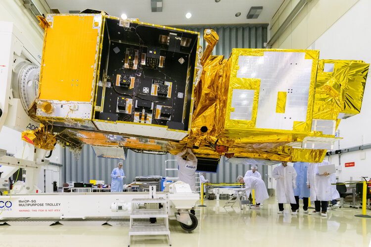
ESA’s ESTEC Test Centre in the Netherlands has completed its initial test campaign for the future of European weather forecasting – MetOp Second Generation.
20191125-VŘ Ředitel/ka odboru správy DMVS a RÚIAN
25.11.2019 15:12 ČÚZK - předpisy a opatření Český úřad zeměměřický a katastrální zveřejnil novou aktualitu: Oznámení o vyhlášení výběrového řízení na obsazení služebního místa Ředitel/ředitelka odboru správy DMVS a RÚIAN.20191125-VŘ Ředitel/ka odboru správy DMVS a RÚIAN
25.11.2019 15:12 ČÚZK /Aktuality-resort/2019/20191125-VR-Reditel-ka-odboru-spravy-DMVS-a-RUIANŘeditel/ředitelka odboru správy DMVS a RÚIAN
25.11.2019 15:00 ČÚZK - předpisy a opatření Český úřad zeměměřický a katastrálnívypisuje výběrové řízení na místo
Ředitel/ředitelka odboru správy DMVS a RÚIAN
Ředitel/ředitelka odboru správy DMVS a RÚIAN
25.11.2019 15:00 ČÚZK /Urady/Cesky-urad-zememericky-a-katastralni/Uredni-deska/Oznameni-a-jina-uredni-sdeleni/Volna-mista/DMS/Reditel-reditelka-odboru-spravy-DMVS-a-RUIANŘeditel/ředitelka odboru správy DMVS a RÚIAN
25.11.2019 15:00 ČÚZK - volná místa Český úřad zeměměřický a katastrální vypisuje výběrové řízení na místo Ředitel/ředitelka odboru správy DMVS a RÚIANvrchní referent/rada – správa dokumentace katastru na Katastrálním pracovišti Nový Jičín
25.11.2019 13:55 ČÚZK - volná místa Katastrální úřad pro Moravskoslezský kraj Katastrální pracoviště Nový Jičín vypisuje výběrové řízení na místo vrchní referent/rada – správa dokumentace katastru na Katastrálním pracovišti Nový Jičínvrchní referent/rada – správa dokumentace katastru na Katastrálním pracovišti Nový Jičín
25.11.2019 13:55 ČÚZK /Urady/Katastralni-urady/Katastralni-urady/Katastralni-urad-pro-Moravskoslezsky-kraj/Uredni-deska/Oznameni-a-jina-uredni-sdeleni/Volna-mista/DMS/vrchni-referent-rada-–-sprava-dokumentace-katastruvrchní referent/rada – správa dokumentace katastru na Katastrálním pracovišti Nový Jičín
25.11.2019 13:55 ČÚZK - předpisy a opatření Katastrální úřad pro Moravskoslezský kraj Katastrální pracoviště Nový Jičínvypisuje výběrové řízení na místo
vrchní referent/rada – správa dokumentace katastru na Katastrálním pracovišti Nový Jičín
Rada/odborný rada – řízení o údajích SGI na Katastrálním pracovišti Opava Katastrálního úřadu pro Mo
25.11.2019 13:51 ČÚZK - předpisy a opatření Katastrální úřad pro Moravskoslezský kraj Katastrální pracoviště Opavavypisuje výběrové řízení na místo
Rada/odborný rada – řízení o údajích SGI na Katastrálním pracovišti Opava Katastrálního úřadu pro Moravskoslezský kraj
Rada/odborný rada – řízení o údajích SGI na Katastrálním pracovišti Opava Katastrálního úřadu pro Mo
25.11.2019 13:51 ČÚZK /Urady/Katastralni-urady/Katastralni-urady/Katastralni-urad-pro-Moravskoslezsky-kraj/Uredni-deska/Oznameni-a-jina-uredni-sdeleni/Volna-mista/DMS/Rada-odborny-rada-–-rizeni-o-udajich-SGI-na-KatastRada/odborný rada – řízení o údajích SGI na Katastrálním pracovišti Opava Katastrálního úřadu pro Mo
25.11.2019 13:51 ČÚZK - volná místa Katastrální úřad pro Moravskoslezský kraj Katastrální pracoviště Opava vypisuje výběrové řízení na místo Rada/odborný rada – řízení o údajích SGI na Katastrálním pracovišti Opava Katastrálního úřadu pro MoVrchní referent/rada – správa dokumentace katastru na Katastrálním pracovišti Nový Jičín
25.11.2019 13:44 ČÚZK - volná místa Katastrální úřad pro Moravskoslezský kraj, Katastrální pracoviště Nový Jičín vypisuje výběrové řízení na místo Vrchní referent/rada – správa dokumentace katastru na Katastrálním pracovišti Nový JičínVrchní referent/rada – správa dokumentace katastru na Katastrálním pracovišti Nový Jičín
25.11.2019 13:44 ČÚZK - předpisy a opatření Katastrální úřad pro Moravskoslezský kraj, Katastrální pracoviště Nový Jičínvypisuje výběrové řízení na místo
Vrchní referent/rada – správa dokumentace katastru na Katastrálním pracovišti Nový Jičín
Vrchní referent/rada – správa dokumentace katastru na Katastrálním pracovišti Nový Jičín
25.11.2019 13:44 ČÚZK /Vrchni-referent-rada-–-sprava-dokumentace-katastruStrojnické tabulky on-line – tady je doopravdy najdete
25.11.2019 13:18 Konstruktér Strojnické tabulky představují pro každého strojaře zásadní zdroj informací. V době, kdy většina konstrukčních prací vzniká [...]Vvrchní referent/rada – správa dokumentace katastru na Katastrálním pracovišti Nový Jičín
25.11.2019 12:20 ČÚZK /Vvrchni-referent-rada-–-sprava-dokumentace-katastrVvrchní referent/rada – správa dokumentace katastru na Katastrálním pracovišti Nový Jičín
25.11.2019 12:20 ČÚZK - předpisy a opatření Katastrální úřad pro Moravskoslezský kraj, Katastrální pracoviště Nový Jičínvypisuje výběrové řízení na místo
Vvrchní referent/rada – správa dokumentace katastru na Katastrálním pracovišti Nový Jičín
Vvrchní referent/rada – správa dokumentace katastru na Katastrálním pracovišti Nový Jičín
25.11.2019 12:20 ČÚZK - volná místa Katastrální úřad pro Moravskoslezský kraj, Katastrální pracoviště Nový Jičín vypisuje výběrové řízení na místo Vvrchní referent/rada – správa dokumentace katastru na Katastrálním pracovišti Nový Jičín19_03556_3_oznameni_o_vyhlasen_vyberoveho_rizeni_SGI_OP_signed
25.11.2019 12:13 ČÚZK /19_03556_3_oznameni_o_vyhlasen_vyberoveho_rizeni_S19_03556_3_oznameni_o_vyhlasen_vyberoveho_rizeni_SGI_OP_signed
25.11.2019 12:13 ČÚZK - předpisy a opatření Katastrální úřad pro Moravskoslezský kraj, Katastrální pracoviště Opavavypisuje výběrové řízení na místo
Rada/odborný rada – řízení o údajích SGI na Katastrálním pracovišti Opava Katastrálního úřadu pro Moravskoslezský kraj
19_03556_3_oznameni_o_vyhlasen_vyberoveho_rizeni_SGI_OP_signed
25.11.2019 12:13 ČÚZK - předpisy a opatření Katastrální úřad pro Moravskoslezský kraj, Katastrální pracoviště Opavavypisuje výběrové řízení na místo
19_03556_3_oznameni_o_vyhlasen_vyberoveho_rizeni_SGI_OP_signed
19_03556_3_oznameni_o_vyhlasen_vyberoveho_rizeni_SGI_OP_signed
25.11.2019 12:13 ČÚZK - volná místa Katastrální úřad pro Moravskoslezský kraj, Katastrální pracoviště Opava vypisuje výběrové řízení na místo 19_03556_3_oznameni_o_vyhlasen_vyberoveho_rizeni_SGI_OP_signedAktualizace dat v mapových aplikacích
25.11.2019 7:35 Jihočeský kraj Mapová aplikace Technická infrastruktura a mapová aplikace Zastavěné území byly aktualizovány k 25.11.2019.Pracovní nabídka z OECD
25.11.2019 7:20 Katedra geoinformatiky UP OlomoucDostala se k nám skvělá nabídka práce pro OECD (Organizace pro ekonomickou spolupráci a rozvoj), která sdružuje nejvyspělejší země světa včetně České republiky. Možná znáte jejich databázi – https://data.oecd.org/. No a právě zpracování geografických dat je nabídkou této pozice. Zákulisní informace říkají, že velmi dobře placené… Více v přiloženém PDF.
The post Pracovní nabídka z OECD appeared first on Katedra geoinformatiky.
"Industry and Climate Change and Six New Europes" by Susan Smith
24.11.2019 10:15 GISCafe.com Webcasts-WebinarsNovember 1989 a pozemkové úpravy
23.11.2019 19:49 Komora pozemkových úprav SR
Pri spomienke na udalosti spred tridsiatich rokov, ktoré znamenali zásadnú zmenu politického režimu, je záhodno spomenúť aj zmeny, ktorými odvtedy prešla evidencia pozemkového vlastníctva a spôsob, akým nazeráme na pozemkové úpravy....
Kratos’ XQ-58A Valkyrie Awarded Aviation Week’s Laureate Award for Defense Technology & Innovation
22.11.2019 23:28 GISCafe.com Webcasts-Webinars SAN DIEGO, Nov. 22, 2019 (GLOBE NEWSWIRE) -- Kratos Defense & Security Solutions, Inc. (Nasdaq: KTOS), a leading National Security Solutions …Hexagon Broadens its Smart Factory Solutions Portfolio With the Acquisition of Volume Graphics
22.11.2019 23:28 GISCafe.com Webcasts-Webinars NACKA STRAND, Sweden, Nov. 22, 2019 — (PRNewswire) — Hexagon AB, a global leader in sensor, software and autonomous solutions, today …Sony Expands Capabilities and Market Presence of its Smart Agriculture Solution
22.11.2019 23:28 GISCafe.com Webcasts-Webinars -- Version 2.0 Software Update Implements Industry Feedback to Introduce AI-enabled Features --PARAMUS, N.J., Nov. 22, 2019 — (PRNewswire) …
Using Digital Twins to Refine Water Operations
22.11.2019 22:08 Bentley SystemsPress Coverage
WaterOnline, USA
Read the articleThe Rise of the Digital Twins
22.11.2019 22:04 Bentley SystemsPress Coverage
Global Construction magazine, UK
Read the articleLooking Back, Looking Forward with Tech Experts Keith and Greg Bentley
22.11.2019 22:02 Bentley SystemsPress Coverage
ENR, USA
Read the articlePredictive Maintenance and Machine Learning will Revolutionize Reliability
22.11.2019 21:58 Bentley SystemsPress Coverage
Asia Pacific Metalworking Equipment News, South East Asia
Read the articleHow better data management improves utility efficiency, compliance and decision-making
22.11.2019 21:52 Bentley SystemsPress Coverage
Utility Dive, USA
Read the articleJaký je Topcon GTL-1000? Zúčastněte se webináře, na kterém se dozvíte detaily
22.11.2019 18:51 GeoBusiness Web časopisu Zeměměřič informoval, že ve středu 27. listopadu se uskuteční webinář o TOPCON GTL-1000, což je integrovaný kompaktní skener s plně vybavenou robotickou totální stanicí. GTL-1000 je již nominován na ocenění za inovace a představuje revoluční řešení pro zachycení reality v reálném čase a jednodušší pracovní postup při ověřování stavebních konstrukcí. Dodavatelům na stavbě […]Webinář o GTL-1000 od Topconu
22.11.2019 18:37 ZeměměřičVe středu 27. listopadu se uskuteční webinář o TOPCON GTL-1000, což je integrovaný kompaktní skener s plně vybavenou robotickou totální stanicí. GTL-1000 je již nominován na ocenění za inovace a představuje revoluční řešení pro zachycení reality v reálném čase a jednodušší pracovní postup při ověřování konstrukcí. Dodavatelům na stavbě má pomáhat zvyšovat produktivitu, minimalizovat chyby a nepřekračovat náklady. Webinář bude v angličtině. Zde se […]
The post Webinář o GTL-1000 od Topconu appeared first on Zeměměřič.
20191122-VŘ Analytik-projektant
22.11.2019 15:23 ČÚZK - předpisy a opatření Český úřad zeměměřický a katastrální zveřejnil novou aktualitu: Oznámení o vyhlášení výběrového řízení na obsazení služebního místa Analytik/analytička - projekt/ka.20191122-VŘ Analytik-projektant
22.11.2019 15:23 ČÚZK /Aktuality-resort/2019/20191122-VR-Analytik-projektantAnalytik/analytička-projektant/ka
22.11.2019 14:29 ČÚZK - volná místa Český úřad zeměměřický a katastrální vypisuje výběrové řízení na místo Analytik/analytička-projektant/kaAnalytik/analytička-projektant/ka
22.11.2019 14:29 ČÚZK /Urady/Cesky-urad-zememericky-a-katastralni/Uredni-deska/Oznameni-a-jina-uredni-sdeleni/Volna-mista/DMS/Analytik-analyticka-projektant-kaAnalytik/analytička-projektant/ka
22.11.2019 14:29 ČÚZK - předpisy a opatření Český úřad zeměměřický a katastrálnívypisuje výběrové řízení na místo
Analytik/analytička-projektant/ka
Firmy při vývoji výrobků čím dál častěji spoléhají na digitální simulace
22.11.2019 14:03 Konstruktér Zájem o software pro simulace (CAE) v procesu vývoje výrobků se v posledních letech stále zvyšuje. Podle [...]Aktualizovaná mapa pozemkových úprav v SR
22.11.2019 14:00 Komora pozemkových úprav SR
Prinášame aktualizovanú prehľadnú mapu SR s vyznačením katastrálnych území, v ktorých sú ukončené alebo plánované pozemkové úpravy
Aktualizovaná prehľadná mapa pozemkových úprav v SR
22.11.2019 14:00 Komora pozemkových úprav SRPrinášame aktualizovanú prehľadnú mapu SR s vyznačením katastrálnych území, v ktorých sú ukončené alebo plánované pozemkové úpravy
Výběrové řízení inspektor/ka - právník (ZKI v Praze - obor služby 55.)
22.11.2019 13:48 ČÚZK - předpisy a opatření Zeměměřický a katastrální inspektorát v Praze zveřejnil novou aktualitu: Vyhlášení výběrového řízení na služební místo - Inspektor/ka - právník Zeměměřického a katastrálního inspektorátu v Praze (obor služby 55.)Výběrové řízení inspektor/ka - právník (ZKI v Praze - obor služby 55.)
22.11.2019 13:48 ČÚZK /Urady/Zememericke-a-katastralni-inspektoraty/Zememericke-a-katastralni-inspektoraty/Zememericky-a-katastralni-inspektorat-v-Praze/O-uradu/Aktuality/Vyberove-rizeni-inspektor-ka-pravnik-(ZKI-v-Pr-(2)Inspektor/ka – právník Zeměměřického a katastrálního inspektorátu v Praze (obor služby 55.)
22.11.2019 13:46 ČÚZK - volná místa Zeměměřický a katastrální inspektorát v Praze vypisuje výběrové řízení na místo Inspektor/ka – právník Zeměměřického a katastrálního inspektorátu v Praze (obor služby 55.)Inspektor/ka – právník Zeměměřického a katastrálního inspektorátu v Praze (obor služby 55.)
22.11.2019 13:46 ČÚZK /Urady/Zememericke-a-katastralni-inspektoraty/Zememericke-a-katastralni-inspektoraty/Zememericky-a-katastralni-inspektorat-v-Praze/Uredni-deska/Oznameni-a-jina-uredni-sdeleni/Volna-mista/DMS/Inspektor-ka-–-pravnik-Zememerickeho-a-katastralniInspektor/ka – právník Zeměměřického a katastrálního inspektorátu v Praze (obor služby 55.)
22.11.2019 13:46 ČÚZK - předpisy a opatření Zeměměřický a katastrální inspektorát v Prazevypisuje výběrové řízení na místo
Inspektor/ka – právník Zeměměřického a katastrálního inspektorátu v Praze (obor služby 55.)
Pracovník/nice hospodářské správy
22.11.2019 11:57 Zeměměřický úřad Zeměměřický úřadvypisuje výběrové řízení na místo
Pracovník/nice hospodářské správy
Pracovník/nice hospodářské správy
22.11.2019 11:57 ČÚZK - předpisy a opatření Zeměměřický úřadvypisuje výběrové řízení na místo
Pracovník/nice hospodářské správy
Pracovník/nice hospodářské správy
22.11.2019 11:57 ČÚZK - volná místa Zeměměřický úřad vypisuje výběrové řízení na místo Pracovník/nice hospodářské správyPracovník/nice hospodářské správy
22.11.2019 11:57 ČÚZK /Urady/Zememericky-urad/Volna-mista/Pracovnik-nice-hospodarske-spravyNový přijímač GNSS
22.11.2019 11:45 Středočeský kraj ro pracovníky krajského úřadu Středočeského kraje byl zakoupen nový ruční GNSS přijímač. Jedná se o model Trimble TDC150 Handheld a nahrazuje stávající zařízení GPS z roku 2005. Zařízení tohoto druhu používají pracovníci pro sběr prostorových dat, jako např. hraniční body ZCHÚ, významná výskytiště zvláště chráněných druhů, určení hranic pozemků pro umístění cyklotras, prověření umístění rozestavěné liniové stavby podle projektové dokumentace. Nový model umožňuje mapovat objekty s přesností až 10 cm. Součástí dodávky bylo i odborné zaškolení obsluhy. Nyní je zaškoleno 8 pracovníků z různých odborů, zejména Odboru životního prostředí a zemědělství, Odboru majetku, Odboru dopravy a Odboru územního plánování a stavebního řádu. Zakoupením tohoto zařízení se očekává vyšší úroveň kvality sběru prostorových dat a tím vyšší efektivita při rozhodovacích procesech. Výběrové řízení na dodávku zboží zajistil Odbor informatiky.Hexagon Wins World Smart City Award
22.11.2019 11:24 GISCafe.com Webcasts-Webinars Smart City Expo World Congress recognizes efforts to connect satellite and operational data and trigger predictive maintenance for …Seville, Spain
22.11.2019 10:00 ESA Observing the Earth Image:
Ahead of next week’s ‘Space19+’ Ministerial Council, the Copernicus Sentinel-2 mission takes us over Seville in southern Spain – the destination for this milestone event.
On 27–28 November, Ministers from ESA’s Member States along with Associate Member Slovenia and Cooperating State Canada will meet in Seville for the ESA Council at Ministerial Level Space19+ to discuss future space activities for Europe and the budget of Europe’s space agency for the coming three years. Space19+ is an opportunity to direct Europe’s ‘next generation’ ambitions in space, and address the challenges facing not only the European space sector, but also European society as a whole.
Seville, visible towards the top right of this image, is the capital of Andalusia and the fourth largest city in Spain. An inland port, it lies on the Guadalquivir River and while the original course of the river is visible snaking through the city on the right, we can see where water has also been redirected into a straighter course on the left. At over 650 km long, the Guadalquivir is one of the longest rivers in Spain, extending way beyond the frame of this image. Nevertheless, it can be seen winding its course all the way from the top right of the image, just south of the Sierra Norte mountain range, to the Gulf of Cádiz where it empties into the Atlantic Ocean. On route, this major river serves as a source for irrigation – here noticeable in the top right of the image, but mainly to the south of Seville where large green agricultural fields appear in sharp contrast to the surrounding drier brown land.
The Doñana National Park lies on the right bank of the Guadalquivir River, at its estuary on the Atlantic Ocean. One of Europe's most important wetland reserves, the park is an area of marsh, shallow streams and sand dunes, and an important site for endangered and migrating birds.
Copernicus Sentinel-2 is a two-satellite mission. Each satellite carries a high-resolution camera that images Earth’s surface in 13 spectral bands. Data from Copernicus Sentinel-2 are used to monitor changes in land cover, agriculture, and coastal and inland waters.
This image, captured on 21 June 2019, is also featured on the Earth from Space video programme.
Earth from Space: Seville
22.11.2019 10:00 ESA Observing the Earth Video:
00:02:39
Video:
00:02:39
In this week's edition of the Earth from Space programme, the Copernicus Sentinel-2 mission takes us over Seville in southern Spain, where ESA's next Ministerial Council will soon take place.
See also Seville, Spain to download the image.
Olofoto album
22.11.2019 9:04 Katedra geoinformatiky UP OlomoucTradiční OLOFOTO z letošní Konference GIS Esri v ČR nově naleznete v našem albu: https://photos.app.goo.gl/1eD8GRrLQVYFuGadA Album budeme průběžně aktualizovat a přidávat fotky i z minulých let.
The post Olofoto album appeared first on Katedra geoinformatiky.
Ohlédnutí za GIS Esri – den 2
22.11.2019 8:59 GISportal.cz
Konference GIS Esri v ČR se tradičně koná během dvou dnů. Letos to bylo 6. a 7. listopadu s podtitulem See What Others Can’t. V předchozím článku jsme vás informovali, co se dělo během úvodního dne, dnes se dozvíte to nejzajímavější ze dne druhého, kdy se dění rozdělilo do všech tří sálů pražského kongresového centra. Čí […]
The post Ohlédnutí za GIS Esri – den 2 appeared first on GISportal.cz.
Ouster Lidar Powers Next Generation Security and Safety Solutions
22.11.2019 3:20 GISCafe.com Webcasts-Webinars Ouster integrates with leading security perception platforms to enable real-time 3D perception, with night vision and 360-degree coverageSAN …
INSPIRE téma Rozšířené Parcely (CPX)
22.11.2019 1:00 Cenia - Katalog metadat ČR - INSPIRE Rozšíření má za cíl poskytovat katastrální mapu s obsahem podle vyhlášky ve vektorové podobě ve struktuře plně v souladu se strukturou danou směrnicí INSPIRE. Data rozšiřují směrnici INSPIRE pro téma katastrální parcely (CP) o věcná břemena, geodetické body, další prvky mapy, původní obloukovou geometrii a o parcely určené definičním bodem (ty pouze v oblastech s analogovou mapou). Vychází z katastrální mapy, která je závazným státním mapovým dílem velkého měřítka, obsahuje body polohového bodového pole, polohopis a popis a může mít formu digitální mapy, analogové mapy nebo digitalizované mapy. Publikovaná data obsahují katastrální území pro celou Českou Republiku, parcely a jejich hranice, věcná břemena, další prvky mapy a původní obloukovou geometrii z území, kde je digitální mapa (k 18. 11. 2019 je to 96,64% území České republiky, t.j. 76 215,40km2) a ve zbytku území katastrální parcely určené pouze definičním bodem (tedy bez hranic a polygonu). Katastrální parcely a hranice obsahují oproti datové sadě INSPIRE některé atributy navíc. Jedná se o typ hranice, způsob využití území, druh pozemku, vazbu na budovu a o mapové značky. Více katastrální zákon 344/1992 SB., katastrální vyhláška č.26/2007 Sb. v platném znění a INSPIRE Data Specification on Cadastral Parcels v 3.0.1. Data ve formátu GML 3.2.1 jsou validní proti schématu XML pro Rozšířené Parcely (CPX) ve verzi 4.0.Katastrální mapa ve formátech DGN a DXF poskytovaná v e-shopu
22.11.2019 1:00 Cenia - Katalog metadat ČR - INSPIRE Katastrální mapa je závazným státním mapovým dílem velkého měřítka, obsahuje body polohového bodového pole, polohopis a popis. Katastrální mapa ve vektorové podobě je poskytována zdarma ve formátu DGN a DXF a obsahuje prvky Digitální katastrální mapy (DKM) a Katastrální mapy digitalizované (KMD), tedy bodová pole, budovy, další prvky mapy, hranice parcel, katastrální hranice, parcely katastru nemovitostí, prvky orientační mapy a hranice věcného břemene. Z důvodu použití formátu DGN produkt neobsahuje značky na liniích a oblouky jsou nahrazeny lomenými čárami. Katastrální mapa ve vektorové podobě k 18. 11. 2019 pokrývá 96,64% území České republiky, t.j. 76 215,40km2. Více katastrální vyhláška č.357/2013 Sb. v platném znění.Katastrální mapa v rastrové podobě poskytovaná v e-shopu
22.11.2019 1:00 Cenia - Katalog metadat ČR - INSPIRE Katastrální mapa v rastrové podobě je poskytována za úplatu a obsahuje analogovou mapu s kompletní kresbou. Analogová mapa pokrývá 3,21 % území České republiky, což je 2 534,82km2. Více katastrální vyhláška č.357/2013 Sb. v platném znění.Pozvánka na akci „První zkušenosti z revizí katastru, věcná břemena“
21.11.2019 21:41 Spolek zeměměřičů Brno Dobrý den, Český svaz geodetů a kartografů vás zve na velice zajímavou odbornou akci „První zkušenosti z revizí katastru, věcná břemena“, která se bude konat ve středu 15.ledna 2020 v Praze 1, Novotného lávka 5. Bližší informace jsou na přiložené pozvánce Pozvánka – První zkušenosti s revizí Elektronická přihláška: http://csgk.fce.vutbr.cz/Oakce/A120 Těšíme... Read more »Linda van den Brink receives OGC’s 2019 Gardels Award
21.11.2019 20:32 GISCafe.com Webcasts-Webinars Congratulations to Linda van den Brink, awarded the 2019 Gardels Award for being “an outstanding representative both internal to OGC and …Manatee County Selects Industry Leader Hexagon to Deploy Public Safety Systems in the Cloud
21.11.2019 18:22 Hexagon Safety & InfrastructureManatee County, Florida, has selected Hexagon’s Safety & Infrastructure division to migrate its public safety systems to the cloud with HxGN OnCall, a comprehensive portfolio of next-generation public safety solutions.
The project, expected to go live in 2020, will support all police, fire and EMS agencies by upgrading the county’s computer-aided dispatch (CAD), mobile and analytics systems to SaaS deployments of HxGN OnCall solutions on Microsoft Azure. The move will help Manatee County increase flexibility and gain access to the most advanced public safety technologies available. It will also increase efficiency by replacing major system upgrades with more frequent updates, provide disaster recovery applications and, most importantly, help agencies better protect and serve the community.
A long-time customer of Hexagon, Manatee County was instrumental in the development of the new HxGN OnCall portfolio, which officially launched in June 2019. The team participated in a pilot program for the software, offering helpful feedback throughout the process.
“We are proud to support Manatee County in their move to the cloud and are grateful for the vital role they played during the development of HxGN OnCall, our new portfolio of next-gen public safety solutions,” said Ben Ernst, vice president and general manager of U.S. Public Safety for Hexagon’s Safety & Infrastructure division. “The Manatee County team is well-respected among public safety leaders and known for their innovative initiatives, making them the ideal partner for developing a solution that will transform the industry.”
“Moving our public safety systems to the cloud has been a priority for our organization, and partnering with Hexagon gives us peace of mind to make the leap,” said Jacob Saur, director of public safety, Manatee County Government. “As a Hexagon customer for 20 years, we are excited to begin this new chapter with an organization we can trust and that has the industry experience to deliver a solution that fits our needs today and in the future.”
To modernize systems and improve service quality, Manatee County will deploy HxGN OnCall Dispatch, HxGN OnCall Analytics, HxGN OnCall Dispatch | Mobile Unit and HxGN OnCall Dispatch | Mobile Responder.
For more information about HxGN OnCall managed service solutions, visit www.hexagonsafetyinfrastructure.com/managedservice.
Digital Global Systems Joins Nevada-Global Drone Trade Alliance
21.11.2019 17:55 GISCafe.com Webcasts-Webinars TYSONS, Va., Nov. 20, 2019 — (PRNewswire) — Digital Global Systems Inc. (DGS) has partnered with the Nevada Institute for …Maxar Commends Senate Commerce Committee’s Passage of NASA Authorization Bill
21.11.2019 17:55 GISCafe.com Webcasts-Webinars WESTMINSTER, Colo. — (BUSINESS WIRE) — November 21, 2019 —Maxar Technologies (NYSE:MAXR) (TSX:MAXR), a trusted partner and …
Blickfeld to debut full automotive LiDAR suite at CES 2020
21.11.2019 17:55 GISCafe.com Webcasts-Webinars Live demonstrations in Las Vegas to include CES 2020 Innovation Awards Honoree Blickfeld CubeMUNICH — (BUSINESS WIRE) — November 21, …
ČÚZK v pátek 22.11.2019 od 15:
21.11.2019 17:12 GEUSware ČÚZK v pátek 22.11.2019 od 15:00 do 19:00 zcela přeruší provoz Dálkového přístupu (DP) i Webových služeb dálkového přístupu (WSDP). Z tohoto důvodu budou v GEUSu nefunkční Podklady měření a Odesílání GP.Smoke in New South Wales
21.11.2019 17:00 ESA Observing the Earth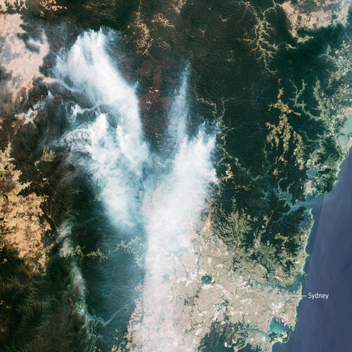 Image:
The Copernicus Sentinel-2 mission captured the plumes of smoke from the bushfires in Australia. The recent blazes triggered a ‘hazardous’ air quality warning for Sydney – the highest level on Australia’s Air Quality Index.
In this image, captured on 21 November 2019 at 00:02 GMT (11:02 local time), smoke from the Gospers Mountain bushfires, northwest of Sydney, can be seen drifting southwards. Residents with respiratory conditions were advised by authorities to stay indoors, as over 50 people have been treated owing to complications from the smoke.
According to the New South Wales Rural Fire Service, as of 21:00 local time, there were over 60 bush and grass fires burning in New South Wales, of which over 20 still need to be contained. In Victoria, another 60 blazes are burning – although the exact number is unknown as new fires have been sparked by recent lightning.
Hundreds of bushfires have been burning this month in Australia, with the greatest damage seen in New South Wales and Queensland.
KÚ-05946/2019
21.11.2019 15:21 ČÚZK - předpisy a opatření Katastrální úřad pro hlavní město Prahu - Katastrální pracoviště Praha zveřejnil novou aktualitu: Ředitel úřadu vyhlašuje výběrové řízení na služební místo: rada/odborný rada - právníkKÚ-05946/2019
21.11.2019 15:21 ČÚZK /Urady/Katastralni-urady/Katastralni-urady/Katastralni-urad-pro-hlavni-mesto-Prahu/O-uradu/Aktuality/KU-05946-2019rada/odborný rada - právník
21.11.2019 15:17 ČÚZK - předpisy a opatření Katastrální úřad pro hlavní město Prahu - Katastrální pracoviště Prahavypisuje výběrové řízení na místo
rada/odborný rada - právník
rada/odborný rada - právník
21.11.2019 15:17 ČÚZK - volná místa Katastrální úřad pro hlavní město Prahu - Katastrální pracoviště Praha vypisuje výběrové řízení na místo rada/odborný rada - právníkrada/odborný rada - právník
21.11.2019 15:17 ČÚZK /Urady/Katastralni-urady/Katastralni-urady/Katastralni-urad-pro-hlavni-mesto-Prahu/Uredni-deska/Oznameni-a-jina-uredni-sdeleni/Volna-mista/DMS/rada-odborny-rada-pravnik-(1)Seminář o prvních zkušenostech s revizemi KN
21.11.2019 15:12 ZeměměřičČeský svaz geodetů a kartografů zve na seminář „První zkušenosti z revizí katastru, věcná břemena“. Akce se bude konat ve středu 15. ledna 2020 (budova ČSVTS, Novotného lávka 5, Praha 1, kongresový sál č. 319). Akce začíná v 9:30 hod, předpokládaný konec je odpoledne v 15 hod. I. BLOK 9:30 až 11:00 hod. 1. Úvod – Ing. Karel Švarc, KÚ 2. Revize […]
The post Seminář o prvních zkušenostech s revizemi KN appeared first on Zeměměřič.
Firma Geotech použila lidar pro skenování sjezdovky
21.11.2019 14:51 GeoBusiness Web časopisu Zeměměřič informoval o použití lidaru lidaretto pro skenování průběhu lyžařské sjezdovky. Slovenská firma Geotech použila své vlastní lidarové řešení (více o lidarettu v rozhovoru s Erikem Frohmannem). Na videu geodeti skenují sjezdovky ve ski resortu Štrbské Pleso ve Vysokých Tatrách. Jako nejvhodnější varianta měření se ukázala pěší chůze s lidarettem na zádech. Výsledný […]EU space infrastructure guarantees leadership in security and defence
21.11.2019 14:24 European GNSS Agency
The European Union’s space infrastructure and know-how provide the assets needed to guarantee leadership in the area of security and defence policy. At a meeting of the European Parliament's Subcommittee on Security and Defence (SEDE) on 12 November European GNSS Agency (GSA) Chief Operating Officer Pascal Claudel spoke about how the European Union's space programmes contribute to its strategic autonomy in the area of security and defence.
Galileo, EGNOS and Copernicus offer the European Union and its Member States the fundamental tools needed for independence in decision-making through the navigation, localisation, Earth observation, communication and surveillance services that they provide.
SEDE Committee Chair Nathalie Loiseau opened the meeting with a comment on the security and defence dimension of space, noting that Europe’s economies, societies, infrastructures and public services policies are becoming more and more dependent on space. “Space has become a critical strategic element for developed societies. This makes us vulnerable, so we need to be aware of this in our security and defence policy,” she said.
In his speech at the meeting, Claudel noted that the new Regulation on the space programme passed in April further strengthens the link between space, defence and security by creating synergies between the fields of navigation, Earth observation and communication. “These synergies will lead to improved applications for the detection and fight against global natural disasters,” he said.
Essential culture of security
Claudel also noted that the development of space surveillance, the Space Situational Awareness (SSA) programme, is essential for ensuring the protection of the EU's space capabilities. The SSA programme is designed to support Europe's independent access and utilisation of space by providing timely and accurate information on the space environment, and particularly hazards to in-orbit and ground infrastructure.
Read this: Europe’s economy is increasingly dependent on space - ITRE committee hears
“Security is one of the 3 major missions entrusted to the GSA, including the Security Accreditation Board (SAB). Although an independent entity, the SAB is supported by the GSA in its mission, which is to ensure compliance between European GNSS standards and the safety regulations of the European Union,” Claudel said.
He said that, in order to strengthen the EU's Security and Defence Policy, a security culture at the service of the EU's space programmes is essential. “The experience gained by the GSA through the operations of Galileo in terms of security (including cybersecurity) is fundamental to reinforce synergies and the sharing of space resources in the service of our security and security policy,” he said.
Cornerstone of government space use
Along with security, the GSA COO also touched on the other 2 key areas in which the GSA has acquired solid experience that can be put to the service of all the EU’s space programmes when the Agency’s remit is broadened under the aegis of the European Union Agency for the Space Programme (EUSPA). These are the PRS and Critical Infrastructure.
The Galileo Public Regulated Service (PRS) is an encrypted navigation service for governmental authorised users and sensitive applications that require high continuity. “The PRS service is the cornerstone for governmental use of the European space programmes. It is delivered through a security chain adapted to the needs of the EU Member States and of the European Union.” Claudel said.
And this: PRS – the future is bright!
He said that this requires continuity of services, efficient operational procedures and a high level of security to protect the entire infrastructure and its communications to end users. “The experience gained from the PRS will be crucial for the handling of Galileo navigation, GovSatCom telecommunication and SSA space surveillance information,” he said.
Essential for strategic autonomy
Regarding the protection of critical infrastructures and their synchronisation with satellite navigation systems, he noted that this synchronisation is currently mainly provided by GPS. “It is therefore important that legislation establishes Galileo ahead of time as the main provider of services, in order to ensure autonomy,” he said, adding that this is particularly important in the context of internal security, transport, energy and telecommunications.
As space policy is an essential dimension of our strategic autonomy, it is essential to preserve the EU’s sensitive technological and industrial capabilities, which means that it is necessary to be very present on the civilian market because of the difference in terms of budget spending by our competitors, he said.
“This is also why a key goal of the GSA is to promote and stimulate the use of European GNSS in all sectors of the market, thus guaranteeing a work plan for our industry and SMEs, job creation and growth at European level,” he said.
Media note: This feature can be republished without charge provided the European GNSS Agency (GSA) is acknowledged as the source at the top or the bottom of the story. You must request permission before you use any of the photographs on the site. If you republish, we would be grateful if you could link back to the GSA website (http://www.gsa.europa.eu).
EU space infrastructure guarantees leadership in security and defence
21.11.2019 14:24 European GNSS AgencyThe European Union’s space infrastructure and know-how provide the assets needed to guarantee leadership in the area of security and defence policy. At a meeting of the European Parliament's Subcommittee on Security and Defence (SEDE) on 12 November European GNSS Agency (GSA) Chief Operating Officer Pascal Claudel spoke about how the European Union's space programmes contribute to its strategic autonomy in the area of security and defence.
Galileo, EGNOS and Copernicus offer the European Union and its Member States the fundamental tools needed for independence in decision-making through the navigation, localisation, Earth observation, communication and surveillance services that they provide.
SEDE Committee Chair Nathalie Loiseau opened the meeting with a comment on the security and defence dimension of space, noting that Europe’s economies, societies, infrastructures and public services policies are becoming more and more dependent on space. “Space has become a critical strategic element for developed societies. This makes us vulnerable, so we need to be aware of this in our security and defence policy,” she said.
In his speech at the meeting, Claudel noted that the new Regulation on the space programme passed in April further strengthens the link between space, defence and security by creating synergies between the fields of navigation, Earth observation and communication. “These synergies will lead to improved applications for the detection and fight against global natural disasters,” he said.
Essential culture of security
Claudel also noted that the development of space surveillance, the Space Situational Awareness (SSA) programme, is essential for ensuring the protection of the EU's space capabilities. The SSA programme is designed to support Europe's independent access and utilisation of space by providing timely and accurate information on the space environment, and particularly hazards to in-orbit and ground infrastructure.
Read this: Europe’s economy is increasingly dependent on space - ITRE committee hears
“Security is one of the 3 major missions entrusted to the GSA, including the Security Accreditation Board (SAB). Although an independent entity, the SAB is supported by the GSA in its mission, which is to ensure compliance between European GNSS standards and the safety regulations of the European Union,” Claudel said.
He said that, in order to strengthen the EU's Security and Defence Policy, a security culture at the service of the EU's space programmes is essential. “The experience gained by the GSA through the operations of Galileo in terms of security (including cybersecurity) is fundamental to reinforce synergies and the sharing of space resources in the service of our security and security policy,” he said.
Cornerstone of government space use
Along with security, the GSA COO also touched on the other 2 key areas in which the GSA has acquired solid experience that can be put to the service of all the EU’s space programmes when the Agency’s remit is broadened under the aegis of the European Union Agency for the Space Programme (EUSPA). These are the PRS and Critical Infrastructure.
The Galileo Public Regulated Service (PRS) is an encrypted navigation service for governmental authorised users and sensitive applications that require high continuity. “The PRS service is the cornerstone for governmental use of the European space programmes. It is delivered through a security chain adapted to the needs of the EU Member States and of the European Union.” Claudel said.
And this: PRS – the future is bright!
He said that this requires continuity of services, efficient operational procedures and a high level of security to protect the entire infrastructure and its communications to end users. “The experience gained from the PRS will be crucial for the handling of Galileo navigation, GovSatCom telecommunication and SSA space surveillance information,” he said.
Essential for strategic autonomy
Regarding the protection of critical infrastructures and their synchronisation with satellite navigation systems, he noted that this synchronisation is currently mainly provided by GPS. “It is therefore important that legislation establishes Galileo ahead of time as the main provider of services, in order to ensure autonomy,” he said, adding that this is particularly important in the context of internal security, transport, energy and telecommunications.
As space policy is an essential dimension of our strategic autonomy, it is essential to preserve the EU’s sensitive technological and industrial capabilities, which means that it is necessary to be very present on the civilian market because of the difference in terms of budget spending by our competitors, he said.
“This is also why a key goal of the GSA is to promote and stimulate the use of European GNSS in all sectors of the market, thus guaranteeing a work plan for our industry and SMEs, job creation and growth at European level,” he said.
Media note: This feature can be republished without charge provided the European GNSS Agency (GSA) is acknowledged as the source at the top or the bottom of the story. You must request permission before you use any of the photographs on the site. If you republish, we would be grateful if you could link back to the GSA website (http://www.gsa.europa.eu).
Sjezdovky a lidar. Podívejte se na slovenské Lidaretto v akci
21.11.2019 14:13 ZeměměřičSlovenská firma Geotech na svém Youtube kanálu představila možnost využití jejich lidarového řešení lidaretto pro měření na sjezdovkách. Po průchodu s lidarem na zádech získá zákazník 3D model z laserového skenování. Na videu geodeti skenují sjezdovky ve ski resortu Štrbské Pleso ve Vysokých Tatrách. Jako nejvhodnější varianta měření se ukázala pěší chůze s lidarettem na zádech. Tento 3D model […]
The post Sjezdovky a lidar. Podívejte se na slovenské Lidaretto v akci appeared first on Zeměměřič.
Valné zhromaždenie KPÚ SR
21.11.2019 12:37 Komora pozemkových úprav SR
Dňa 5.12.2019 sa uskutoční Valné zhromaždenie KPÚ SR vo Zvolene, v hoteli Tenis
Rada/Odborný rada – Vedoucí oddělení aktualizace katastru nemovitostí
21.11.2019 11:23 ČÚZK /Urady/Katastralni-urady/Katastralni-urady/Katastralni-urad-pro-Karlovarsky-kraj/Uredni-deska/Oznameni-a-jina-uredni-sdeleni/Volna-mista/Rada-Odborny-rada-–-Vedouci-oddeleni-aktualizace-kRada/Odborný rada – Vedoucí oddělení aktualizace katastru nemovitostí
21.11.2019 11:23 ČÚZK - volná místa Katastrální úřad pro Karlovarský kraj - Katastrální pracoviště Sokolov vypisuje výběrové řízení na místo Rada/Odborný rada – Vedoucí oddělení aktualizace katastru nemovitostíRada/Odborný rada – Vedoucí oddělení aktualizace katastru nemovitostí
21.11.2019 11:23 ČÚZK - předpisy a opatření Katastrální úřad pro Karlovarský kraj - Katastrální pracoviště Sokolovvypisuje výběrové řízení na místo
Rada/Odborný rada – Vedoucí oddělení aktualizace katastru nemovitostí
ESIP and OGC invite you to the Coverage Processing and Analysis API Sprint
21.11.2019 11:10 GISCafe.com Webcasts-Webinars Agile development sprint will advance APIs for analytics on coverages, arrays, and gridded data.November 20, 2019: Earth Science Information …
Schneider electric announces a new powerful, feature-filled release of Arcfm designer xi
21.11.2019 11:07 GISCafe.com Webcasts-Webinars Latest release seamlessly supports electric and gas networks, as well as the Utility Network and UPDMFort Collins, Colo., November 20, …