


![]()

zprávy
zdroje zpráv:20230923 - volné místo - Odborný/vrchní referent v OOKO II v TÚ na KÚ pro ÚK
21.9.2023 12:42 ČÚZK - předpisy a opatření Katastrální úřad pro Ústecký kraj zveřejnil novou aktualitu: Nabídka volného místa - Odborný / vrchní referent v oddělení obnovy katastrálního operátu II v technickém odboru na KÚ pro Ústecký kraj20230923 - volné místo - Odborný/vrchní referent v OOKO II v TÚ na KÚ pro ÚK
21.9.2023 12:42 ČÚZK /Urady/Katastralni-urady/Katastralni-urady/Katastralni-urad-pro-Ustecky-kraj/O-uradu/Aktuality/20230923-volne-misto-Odborny-vrchni-referent-v-(2)20230923 - volné místo - Odborný/vrchní referent v OOKO I v TÚ na KÚ pro ÚK
21.9.2023 12:38 ČÚZK - předpisy a opatření Katastrální úřad pro Ústecký kraj zveřejnil novou aktualitu: Nabídka volného místa - Odborný / vrchní referent v oddělení obnovy katastrálního operátu I v technickém odboru na KÚ pro Ústecký kraj20230923 - volné místo - Odborný/vrchní referent v OOKO I v TÚ na KÚ pro ÚK
21.9.2023 12:38 ČÚZK /Urady/Katastralni-urady/Katastralni-urady/Katastralni-urad-pro-Ustecky-kraj/O-uradu/Aktuality/20230923-volne-misto-Odborny-vrchni-referent-v-(1)20230923 - volné místo - Odborný/vrchní referent v OOKO II v TÚ na KÚ pro ÚK
21.9.2023 12:33 ČÚZK /Urady/Katastralni-urady/Katastralni-urady/Katastralni-urad-pro-Ustecky-kraj/O-uradu/Aktuality/20230923-volne-misto-Odborny-vrchni-referent-v-OOK20230923 - volné místo - Odborný/vrchní referent v OOKO II v TÚ na KÚ pro ÚK
21.9.2023 12:33 ČÚZK - předpisy a opatření Katastrální úřad pro Ústecký kraj zveřejnil novou aktualitu: Nabídka volného místa - Odborný / vrchní referent v oddělení obnovy katastrálního operátu II v technickém odboru na KÚ pro Ústecký krajOdborný/vrchní referent v oddělení obnovy katastrálního operátu I v technickém odboru na KÚ pro Úste
21.9.2023 12:10 ČÚZK /Urady/Katastralni-urady/Katastralni-urady/Katastralni-urad-pro-Ustecky-kraj/Uredni-deska/Oznameni-a-jina-uredni-sdeleni/Volna-mista/DMS/Odborny-vrchni-referent-v-oddeleni-obnovy-kata-(2)Odborný/vrchní referent v oddělení obnovy katastrálního operátu I v technickém odboru na KÚ pro Úste
21.9.2023 12:10 ČÚZK - volná místa Katastrální úřad pro Ústecký kraj technický odbor vypisuje výběrové řízení na místo Odborný/vrchní referent v oddělení obnovy katastrálního operátu I v technickém odboru na KÚ pro ÚsteOdborný/vrchní referent v oddělení obnovy katastrálního operátu I v technickém odboru na KÚ pro Úste
21.9.2023 12:10 ČÚZK - předpisy a opatření Katastrální úřad pro Ústecký kraj technický odborvypisuje výběrové řízení na místo
Odborný/vrchní referent v oddělení obnovy katastrálního operátu I v technickém odboru na KÚ pro Ústecký kraj
Odborný/vrchní referent v oddělení obnovy katastrálního operátu II v technickém odboru na KÚ pro Úst
21.9.2023 12:03 ČÚZK - předpisy a opatření Katastrální úřad pro Ústecký kraj technický odborvypisuje výběrové řízení na místo
Odborný/vrchní referent v oddělení obnovy katastrálního operátu II v technickém odboru na KÚ pro Ústecký kraj
Odborný/vrchní referent v oddělení obnovy katastrálního operátu II v technickém odboru na KÚ pro Úst
21.9.2023 12:03 ČÚZK - volná místa Katastrální úřad pro Ústecký kraj technický odbor vypisuje výběrové řízení na místo Odborný/vrchní referent v oddělení obnovy katastrálního operátu II v technickém odboru na KÚ pro ÚstOdborný/vrchní referent v oddělení obnovy katastrálního operátu II v technickém odboru na KÚ pro Úst
21.9.2023 12:03 ČÚZK /Urady/Katastralni-urady/Katastralni-urady/Katastralni-urad-pro-Ustecky-kraj/Uredni-deska/Oznameni-a-jina-uredni-sdeleni/Volna-mista/DMS/Odborny-vrchni-referent-v-oddeleni-obnovy-kata-(1)pracovní pozice „Zásobovač“ v oddělení hospodářské správy kanceláře úřadu
21.9.2023 12:01 ČÚZK - předpisy a opatření Katastrální úřad pro Královéhradecký kraj kancelář ředitelevypisuje výběrové řízení na místo
pracovní pozice „Zásobovač“ v oddělení hospodářské správy kanceláře úřadu
pracovní pozice „Zásobovač“ v oddělení hospodářské správy kanceláře úřadu
21.9.2023 12:01 ČÚZK /Urady/Katastralni-urady/Katastralni-urady/Katastralni-urad-pro-Kralovehradecky-kraj/Volna-mista/DMS/pracovni-pozice-Zasobovac-v-oddeleni-hospodarske-spracovní pozice „Zásobovač“ v oddělení hospodářské správy kanceláře úřadu
21.9.2023 12:01 ČÚZK - volná místa Katastrální úřad pro Královéhradecký kraj kancelář ředitele vypisuje výběrové řízení na místo pracovní pozice „Zásobovač“ v oddělení hospodářské správy kanceláře úřaduodborný rada - vedoucí oddělení právních vztahů k nemovitostem Katastrálního pracoviště Jičín
21.9.2023 11:48 ČÚZK - předpisy a opatření Katastrální úřad pro Královéhradecký kraj Katastrální pracoviště Jičínvypisuje výběrové řízení na místo
odborný rada - vedoucí oddělení právních vztahů k nemovitostem Katastrálního pracoviště Jičín
odborný rada - vedoucí oddělení právních vztahů k nemovitostem Katastrálního pracoviště Jičín
21.9.2023 11:48 ČÚZK - volná místa Katastrální úřad pro Královéhradecký kraj Katastrální pracoviště Jičín vypisuje výběrové řízení na místo odborný rada - vedoucí oddělení právních vztahů k nemovitostem Katastrálního pracoviště Jičínodborný rada - vedoucí oddělení právních vztahů k nemovitostem Katastrálního pracoviště Jičín
21.9.2023 11:48 ČÚZK /Urady/Katastralni-urady/Katastralni-urady/Katastralni-urad-pro-Kralovehradecky-kraj/Uredni-deska/Oznameni-a-jina-uredni-sdeleni/Volna-mista/DMS/odborny-rada-vedouci-oddeleni-pravnich-vztahu-k-neOdborný/vrchní referent v oddělení obnovy katastrálního operátu II v technickém odboru na KÚ pro Úst
21.9.2023 11:44 ČÚZK /Urady/Katastralni-urady/Katastralni-urady/Katastralni-urad-pro-Ustecky-kraj/Uredni-deska/Oznameni-a-jina-uredni-sdeleni/Volna-mista/DMS/Odborny-vrchni-referent-v-oddeleni-obnovy-katastraOdborný/vrchní referent v oddělení obnovy katastrálního operátu II v technickém odboru na KÚ pro Úst
21.9.2023 11:44 ČÚZK - volná místa Katastrální úřad pro Ústecký kraj technický odbor vypisuje výběrové řízení na místo Odborný/vrchní referent v oddělení obnovy katastrálního operátu II v technickém odboru na KÚ pro ÚstOdborný/vrchní referent v oddělení obnovy katastrálního operátu II v technickém odboru na KÚ pro Úst
21.9.2023 11:44 ČÚZK - předpisy a opatření Katastrální úřad pro Ústecký kraj technický odborvypisuje výběrové řízení na místo
Odborný/vrchní referent v oddělení obnovy katastrálního operátu II v technickém odboru na KÚ pro Ústecký kraj
vrchní referent / rada v oddělení aktualizace katastru nemovitostí Katastrálního pracoviště Jičín
21.9.2023 11:38 ČÚZK - předpisy a opatření Katastrální úřad pro Královéhradecký kraj Katastrální pracoviště Jičínvypisuje výběrové řízení na místo
vrchní referent / rada v oddělení aktualizace katastru nemovitostí Katastrálního pracoviště Jičín
vrchní referent / rada v oddělení aktualizace katastru nemovitostí Katastrálního pracoviště Jičín
21.9.2023 11:38 ČÚZK /Urady/Katastralni-urady/Katastralni-urady/Katastralni-urad-pro-Kralovehradecky-kraj/Uredni-deska/Oznameni-a-jina-uredni-sdeleni/Volna-mista/DMS/vrchni-referent-rada-v-oddeleni-aktualizace-katastvrchní referent / rada v oddělení aktualizace katastru nemovitostí Katastrálního pracoviště Jičín
21.9.2023 11:38 ČÚZK - volná místa Katastrální úřad pro Královéhradecký kraj Katastrální pracoviště Jičín vypisuje výběrové řízení na místo vrchní referent / rada v oddělení aktualizace katastru nemovitostí Katastrálního pracoviště Jičín20230921_Odborný / vrchní referent oddělení právních vztahů k nemovitostem
21.9.2023 10:47 ČÚZK - předpisy a opatření Katastrální úřad pro Středočeský kraj - Katastrální pracoviště Rakovník Vyhlášení výběrového řízení: Odborný / vrchní referent oddělení právních vztahů k nemovitostem V části "Úřední deska", v sekci "Oznámení a jiná úřední sdělení" bylo vystaveno "Oznámení o vyhlášení výběrového řízení na obsazení služebního místa odborný rada oddělení právních vztahů k nemovitostem"Odborný / vrchní referent oddělení právních vztahů k nemovitostem
21.9.2023 10:46 ČÚZK - předpisy a opatření Katastrální úřad pro Středočeský kraj Katastrální pracoviště Rakovníkvypisuje výběrové řízení na místo
Odborný / vrchní referent oddělení právních vztahů k nemovitostem
Odborný / vrchní referent oddělení právních vztahů k nemovitostem
21.9.2023 10:46 ČÚZK - volná místa Katastrální úřad pro Středočeský kraj Katastrální pracoviště Rakovník vypisuje výběrové řízení na místo Odborný / vrchní referent oddělení právních vztahů k nemovitostem20230921_Odborný / vrchní referent oddělení aktualizace PI KN I.
21.9.2023 10:32 ČÚZK - předpisy a opatření Katastrální úřad pro Středočeský kraj - Katastrální pracoviště Praha-západ Vyhlášení výběrového řízení: Odborný / vrchní referent oddělení aktualizace PI KN I. V části "Úřední deska", v sekci "Oznámení a jiná úřední sdělení" bylo vystaveno "Oznámení o vyhlášení výběrového řízení na obsazení služebního místa Odborný / vrchní referent oddělení aktualizace PI KN I."Odborný / vrchní referent oddělení aktualizace PI KN I.
21.9.2023 10:29 ČÚZK - předpisy a opatření Katastrální úřad pro Středočeský kraj Katastrální pracoviště Praha-západvypisuje výběrové řízení na místo
Odborný / vrchní referent oddělení aktualizace PI KN I.
Odborný / vrchní referent oddělení aktualizace PI KN I.
21.9.2023 10:29 ČÚZK - volná místa Katastrální úřad pro Středočeský kraj Katastrální pracoviště Praha-západ vypisuje výběrové řízení na místo Odborný / vrchní referent oddělení aktualizace PI KN I.vrchní referent / rada v Katastrálním úřadu pro Liberecký kraj, v oddělení právních vztahů k nemovi
21.9.2023 10:02 ČÚZK - předpisy a opatření Katastrální úřad pro Liberecký kraj - Katastrální pracoviště Liberecvypisuje výběrové řízení na místo
vrchní referent / rada v Katastrálním úřadu pro Liberecký kraj, v oddělení právních vztahů k nemovitostem
vrchní referent / rada v Katastrálním úřadu pro Liberecký kraj, v oddělení právních vztahů k nemovi
21.9.2023 10:02 ČÚZK - volná místa Katastrální úřad pro Liberecký kraj - Katastrální pracoviště Liberec vypisuje výběrové řízení na místo vrchní referent / rada v Katastrálním úřadu pro Liberecký kraj, v oddělení právních vztahů k nemoviodborný referent / vrchní referent – obnova katastrálního operátu v Katastrálním úřadu pro Libereck
21.9.2023 9:49 ČÚZK - předpisy a opatření Katastrální úřad pro Liberecký kraj - Katastrální pracoviště Liberecvypisuje výběrové řízení na místo
odborný referent / vrchní referent – obnova katastrálního operátu v Katastrálním úřadu pro Liberecký kraj
odborný referent / vrchní referent – obnova katastrálního operátu v Katastrálním úřadu pro Libereck
21.9.2023 9:49 ČÚZK - volná místa Katastrální úřad pro Liberecký kraj - Katastrální pracoviště Liberec vypisuje výběrové řízení na místo odborný referent / vrchní referent – obnova katastrálního operátu v Katastrálním úřadu pro LibereckThe buildingSMART openBIM Awards Program 2023 – Winners Announced
21.9.2023 8:26 buildingSMART.orgLondon, (September 20, 2023) buildingSMART International is delighted to announce the full list of winners from the Awards Program 2023. All finalists presented their projects during the buildingSMART International Standards Summit…
The post The buildingSMART openBIM Awards Program 2023 – Winners Announced appeared first on buildingSMART International.
The buildingSMART openBIM Awards Program 2023 – Winners Announced
21.9.2023 8:26 buildingSMART.orgLondon, (September 20, 2023) - buildingSMART International is delighted to announce the full list of winners and special mentions from the openBIM Awards 2023. All the finalists in this year’s…
The post The buildingSMART openBIM Awards Program 2023 – Winners Announced appeared first on buildingSMART International.
APGEO - Doc. Ing. Václav Čada, CSc. novým čestným členem APG
21.9.2023 2:00 Asociace podnikatelů v geomatice Představenstvo APG udělilo titul čestného člena doc. Václavu Čadovi.20230920_Ředitel sekce Katastrálního pracoviště Praha západ – odborný rada
20.9.2023 10:12 ČÚZK - předpisy a opatření Katastrální úřad pro Středočeský kraj - Katastrální pracoviště Praha-západ Vyhlášení výběrového řízení: Ředitel sekce Katastrálního pracoviště Praha západ – odborný rada V části "Úřední deska", v sekci "Oznámení a jiná úřední sdělení" bylo vystaveno "Oznámení o vyhlášení výběrového řízení na obsazení služebního místa Ředitel sekce Katastrálního pracoviště Praha západ – odborný rada"Trio of Sentinel satellites map methane super-emitters
20.9.2023 9:00 ESA Observing the Earth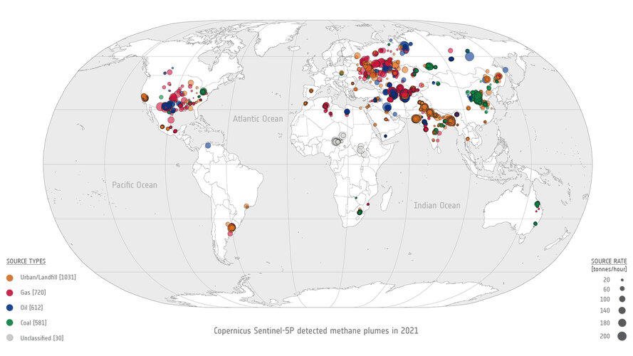
In the quest to address climate change and reduce greenhouse gas emissions, detecting methane leaks – a potent contributor to global warming – has become increasingly vital. Researchers are harnessing the capabilities of cutting-edge satellite technology to monitor these leaks from space.
Změna adresy sídla firmy HRDLIČKA spol. s r.o.
19.9.2023 13:16 Hrdlička Chtěli bychom vás informovat o změně adresy sídla naší společnosti.31. jednání KRS
19.9.2023 11:39 ČÚZK - předpisy a opatření Dne 18. října 2023 proběhne distančně 31. jednání Koordinační rady správců DMVS a DTM.12. jednání TPS
19.9.2023 11:37 ČÚZK - předpisy a opatření Dne 11. října 2023 proběhne distančně 12. jednání Technické pracovní skupiny Koordinační rady správců DMVS a DTM.Konference GIS Esri v ČR zná své hlavní řečníky
19.9.2023 8:21 GISportal.cz
Termín Konference GIS Esri v ČR se pomalu blíží (8. – 9. listopadu), a my Vám proto přinášíme první informace o jejím programu. Hlavní řečníci Na našich webových stránkách se již nyní můžete seznámit s řečníky, kteří letos přijali naše pozvání k vystoupení v úvodním bloku konference. Těšit se můžete na: Ing. Karla Brázdila, CSc., […]
The post Konference GIS Esri v ČR zná své hlavní řečníky appeared first on GISportal.cz.
Introducing HydroBoat 1200 – Multi-Purpose USV Platform for Hydrographic Surveys and Monitoring
19.9.2023 5:40 Satlab Geosolutions🌐 Versatile Integration: Equipped to accommodate a range of hydrographic survey needs, including Single […]
The post Introducing HydroBoat 1200 – Multi-Purpose USV Platform for Hydrographic Surveys and Monitoring appeared first on Global Satellite Positioning Solutions | SatLab Geosolutions AB.
Výběrové řízení
18.9.2023 12:37 ČÚZK - předpisy a opatření Katastrální úřad pro Plzeňský kraj zveřejnil novou aktualitu:Ředitelka Katastrálního úřadu pro Plzeňský kraj jako služební orgán příslušný podle § 10 odst. 1 písm. f) zákona č. 234/2014 Sb., o státní službě, ve znění pozdějších předpisů, vyhlašuje výběrové řízení na služební místo odborný/vrchní referent – obnova katastrálního operátu – OKO0331, na Katastrálním úřadu pro Plzeňský kraj, oddělení obnovy katastrálního operátu 3010, Odbor obnovy katastrálního operátu, se služebním působištěm v Plzni. Na služebním místě je státní služba vykonávána v oboru služby 55. Zeměměřictví a katastr nemovitostí.
Služební místo je zařazeno podle přílohy č. 1 k zákonu o státní službě do 9. platové třídy.
Služba na služebním místě bude vykonávána ve služebním poměru na dobu neurčitou.
Předpokládaným dnem nástupu do služby na služebním místě je 1. listopad 2023 nebo dohodou.
Délka stanovené týdenní služební doby je 40 hodin.
Výběrové řízení na služební místo odborný/vrchní referent - obnova katastrálního operátu
18.9.2023 12:32 ČÚZK - volná místa Katastrální úřad pro Plzeňský kraj odbor obnovy katastrálního operátu vypisuje výběrové řízení na místo Výběrové řízení na služební místo odborný/vrchní referent - obnova katastrálního operátuVýběrové řízení na služební místo odborný/vrchní referent - obnova katastrálního operátu
18.9.2023 12:32 ČÚZK - předpisy a opatření Katastrální úřad pro Plzeňský kraj odbor obnovy katastrálního operátuvypisuje výběrové řízení na místo
Výběrové řízení na služební místo odborný/vrchní referent - obnova katastrálního operátu
Výběrové řízení na služební místo odborný/vrchní referent - obnova katastrálního operátu
18.9.2023 12:32 ČÚZK /Urady/Katastralni-urady/Katastralni-urady/Katastralni-urad-pro-Plzensky-kraj/Uredni-deska/Oznameni-a-jina-uredni-sdeleni/Volna-mista/DMS/Vyberove-rizeni-na-sluzebni-misto-odborny-vrchni-r
Agro vrstvy a ZB GIS
18.9.2023 11:00
ÚGKK SR
V sekcii Geodézia a kartografia/ZBGIS je zverejnené inštruktážne video použitia Agro vrstiev MPRV SR v Mapovom klientovi ZB GIS
Agrovrstvy a ZB GIS
18.9.2023 11:00
ÚGKK SR
V sekcii Geodézia a kartografia/ZBGIS je zverejnené inštruktážne video použitia Agrovrstiev MPRV SR v Mapovom klientovi ZB GIS
Geodet/ka 10PT.
18.9.2023 10:10 ČÚZK - předpisy a opatření Zeměměřický úřadvypisuje výběrové řízení na místo
Geodet/ka 10PT.
Geodet/ka 10PT.
18.9.2023 10:10 ČÚZK - volná místa Zeměměřický úřad vypisuje výběrové řízení na místo Geodet/ka 10PT.Geodet/ka 10PT.
18.9.2023 10:10 ČÚZK /Urady/Zememericky-urad/Uredni-deska/Oznameni-a-jina-uredni-sdeleni/Volna-mista/DMS/Geodet-ka-10PTGeodet/ka 10PT.
18.9.2023 10:10 Zeměměřický úřad Zeměměřický úřadvypisuje výběrové řízení na místo
Geodet/ka 10PT.
3GON Tour 2023 (pozvánka)
18.9.2023 9:20 GISportal.cz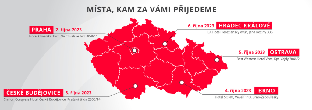
Letošní roadshow firmy 3GON Positioning věnovaná měřické technice se nově zastaví i v Hradci Králové. Místa, kde si budete moci prohlédnout a vyzkoušet měřickou techniku a software, kterými firma 3GON zastupuje na českém trhu, jsou následující: Praha, 2. října České Budějovice, 3. října Brno, 4. října Ostrava, 5. října Hradec Králové, 6. října Program 3GON […]
The post 3GON Tour 2023 (pozvánka) appeared first on GISportal.cz.
Nové číslo GaKO
18.9.2023 8:50
ÚGKK SR
Nové číslo časopisu Geodetického a Kartografického Obzoru 09/2023
Mapy jsou pro každého 2023
18.9.2023 7:17 TopGisTradičně jsme zúčastnili jako hlavní partner již devátého ročníku konference s názvem "Mapy jsou pro každého 2023", která se uskutečnila od 12. do 13. září 2023 na Vysočině. Program konference se letos logicky hodně zaměřoval na právě dokončované projekty Digitální technické mapy krajů a na praktické zkušenosti realizátorů. Shlédli jsme ale i zajímavé příspěvky ...
Článek Mapy jsou pro každého 2023 se nejdříve objevil na TopGis, s.r.o..
Krátká akce v září – sleva 15 % na oblíbené aplikace Autodesku
18.9.2023 0:00 Arkance SystemsFusion 360, AutoCAD, AutoCAD LT a AutoCAD Revit LT Suite ve výhodné akci. Pouze do 21. září 2023.
Zpráva Krátká akce v září – sleva 15 % na oblíbené aplikace Autodesku pochází z arkance-systems.cz.
Krátká akce v září – sleva 15 % na oblíbené aplikace Autodesku
18.9.2023 0:00 Arkance SystemsAutoCAD, AutoCAD LT, AutoCAD Revit LT Suite a Fusion 360 ve výhodné akci. Pouze do 21. září 2023.
Zpráva Krátká akce v září – sleva 15 % na oblíbené aplikace Autodesku pochází z arkance-systems.cz.
New Members Announced
17.9.2023 19:40 buildingSMART.orgLondon, (September 18, 2023) – buildingSMART International is pleased to announce a variety of new members joining as a show of commitment to the development of open standards. Multinational bSI…
The post New Members Announced appeared first on buildingSMART International.
Konference T-Mapy – program letošního 25. setkání
17.9.2023 13:15 GeoBusinessVe dnech 18. a 19. září 2023 se koná 25. ročník setkání zákazníků firmy T-Mapy. Akce s názvem „25. Setkání uživatelů produktů a služeb společnosti T‑MAPY“ se opět koná v hotelu Jezerka v Ústupkách u Seče. První den konference – pondělí 18. září Sekce Města, kraje a další subjekty veřejné správy 10:00 – 10:10 Jsme […]
The post Konference T-Mapy – program letošního 25. setkání appeared first on GeoBusiness.
upgrade na TurboCAD 28 v akci
16.9.2023 20:37 ŠPINAR - software Vážení zákazníci,dovolujeme si Vám nabídnout upgrade na TurboCAD 28 CZ v akční ceně do 23. 9. 2023
upgrade na TurboCAD 28 v akci
16.9.2023 20:37 ŠPINAR - softwareVážení zákazníci,
dovolujeme si Vám nabídnout upgrade na TurboCAD 28 CZ v akční ceně do 23. 9. 2023
The post upgrade na TurboCAD 28 v akci appeared first on ŠPINAR – software.
New Maritime Domain Launched
16.9.2023 18:17 buildingSMART.orgLondon, (September 14, 2023) – buildingSMART International is pleased to announce the "Maritime Domain" has been launched, advancing work done under the "Ports and Waterways" project. The new Maritime Domain…
The post New Maritime Domain Launched appeared first on buildingSMART International.
New Maritime Domain Launched
16.9.2023 18:17 buildingSMART.orgLondon, (September 14, 2023) – buildingSMART International is pleased to announce the "Maritime Domain" has been launched, advancing work done under the "Ports and Waterways" project. The new Maritime…
The post New Maritime Domain Launched appeared first on buildingSMART International.
Publikován největší světový průzkum Drone Industry Barometer 2023, kterého je Aliance opět partnerem
16.9.2023 8:35 UAVADrone Industry Insights zveřejnil výsledky letošního největšího průzkumu Global Drone Industry Barometer 2023, kterého je Aliance opět partnerem. Letošního průzkumu se zúčastnilo 1113 účastníků z 85 zemí. Zde ke stažení:
The post Publikován největší světový průzkum Drone Industry Barometer 2023, kterého je Aliance opět partnerem appeared first on UAV Aliance pro bezpilotní letecký průmysl.
Olomoucky hackathon (pozvánka)
15.9.2023 19:37 GISportal.cz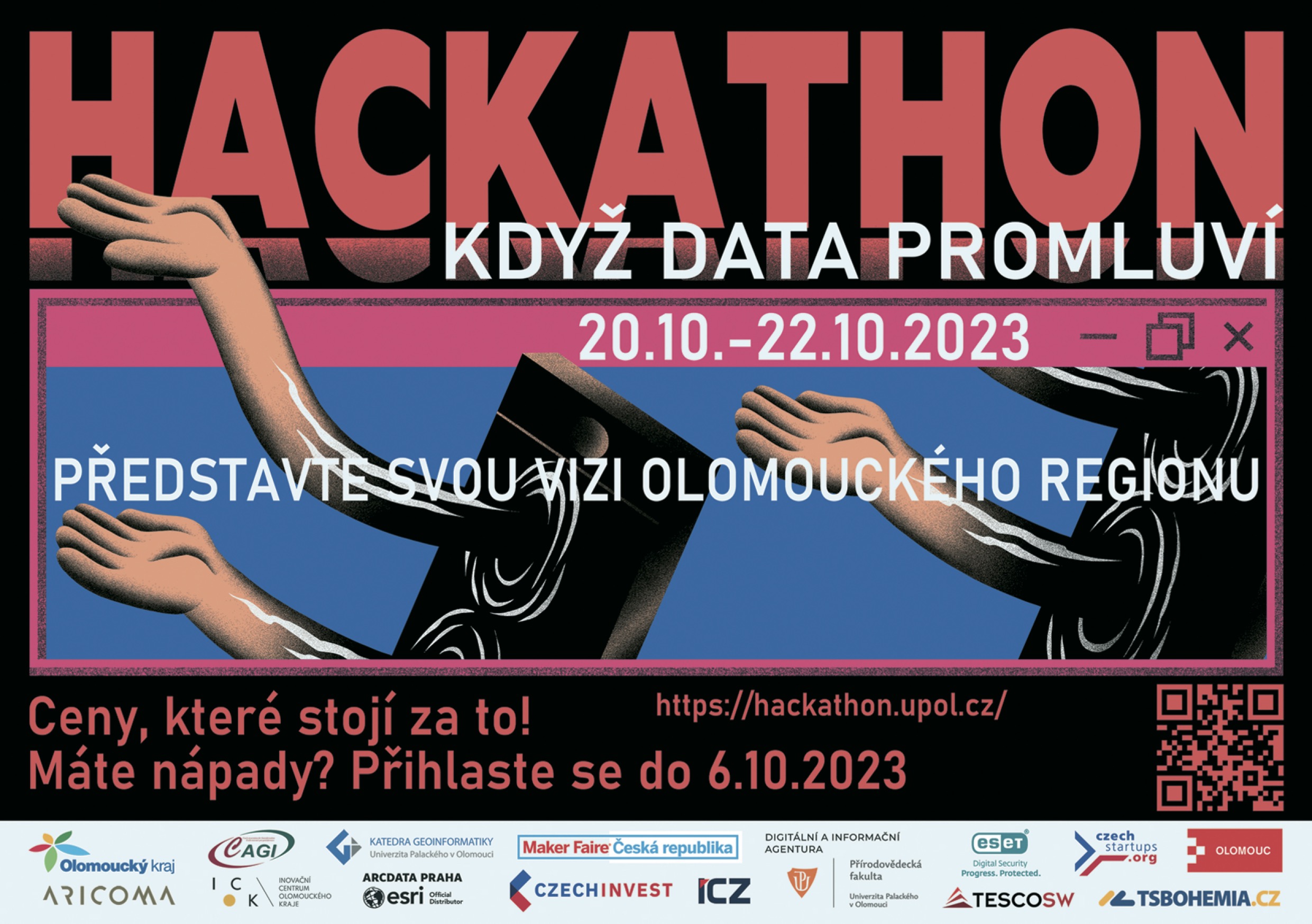
Olomoucký kraj, Univerzita Palackého, město Olomouc a Inovační centrum Olomouckého kraje připravují projekt Hackathon. Víkendová akce si klade za cíl propojit lidi, kteří se budou podílet na vzniku zajímavých projektů. Zájemci se mohou hlásit už teď prostřednictvím webu hackathon.upol.cz, kde také najdou bližší informace. Čas mají do 6. října. Vítězové soutěže se pak mohou těšit […]
The post Olomoucky hackathon (pozvánka) appeared first on GISportal.cz.
Olomoucky hackathon (pozvánka)
15.9.2023 19:37 GISportal.czOlomoucký kraj, Univerzita Palackého, město Olomouc a Inovační centrum Olomouckého kraje připravují projekt Hackathon. Víkendová akce si klade za cíl propojit lidi, kteří se budou podílet na vzniku zajímavých projektů. Zájemci se mohou hlásit už teď prostřednictvím webu hackathon.upol.cz, kde také najdou bližší informace. Čas mají do 6. října. Vítězové soutěže se pak mohou těšit […]
The post Olomoucky hackathon (pozvánka) appeared first on GISportal.cz.
Mapová aplikace ÚPD - nové dokumentace
15.9.2023 16:39 Jihočeský krajV mapové aplikaci Územně plánovací dokumentace obcí byla aktualizována ÚPD obcí ORP České Budějovice – Dubičné, Vrábče, Zliv, České Budějovice, ORP Strakonice – Nihošovice, ORP Trhové Sviny – Ločenice.
Earth from Space: Blooms in the Gulf of Finland
15.9.2023 10:00 ESA Observing the Earth Image:
This Copernicus Sentinel-2 image features swirls of vivid, emerald green algal blooms in the Gulf of Finland.
Image:
This Copernicus Sentinel-2 image features swirls of vivid, emerald green algal blooms in the Gulf of Finland.
HENNLICH – tisk domů na obří 3D tiskárně
15.9.2023 9:50 Arkance SystemsMezioborové, inovativní řešení - unikátní využití Autodesk Fusion 360 se speciálním CAM postprocesorem od Arkance Systems.
Zpráva HENNLICH – tisk domů na obří 3D tiskárně pochází z arkance-systems.cz.
EUSPA: The partner of choice for space-based entrepreneurs
15.9.2023 9:46 European GNSS Agency
Did you know that the GNSS and Earth Observation downstream market generated over EUR 200 billion in revenue in 2021? What’s more, this market is expected to hit the half trillion mark over the next decade.
Not only are these some big numbers – they also represent a BIG opportunity for European start-ups, scale-ups, SMEs, entrepreneurs, innovators and investors.
Helping leverage this opportunity is EUSPA.
In addition to our responsibility for the operational management of the EU Space Programme and for ensuring the continuous provision of its services, EUSPA is also charged with supporting the development of innovative European products and applications and a competitive space industry based on Galileo, EGNOS and Copernicus services.
“EUSPA is the go-to hub for businesses seeking information, expertise, and support in integrating EU space technology into their business solutions,” says EUSPA Executive Director Rodrigo da Costa.
To deliver on this mission, EUSPA offers such funding opportunities as the flagship Horizon Europe and Fundamental Elements mechanisms. Then there’s the EUSPA Space Academy, an online training platform open to those looking to learn the ins and outs of building a space application business. EUSPA also supports a wide range of contests and awards, including the #myEUSpce competition and the popular CASSINI Hackathon.
Space for International Development and Humanitarian Aid
The 6th edition of the CASSINI Hackathon is focused on using EU Space to address the global challenges of international development and humanitarian aid. Galileo and Copernicus offer powerful solutions to ensure access to fundamental necessities such as clean water and a secure food supply, while also providing effective assistance during times of crisis.
Read more: Sustainably supporting 8 billion people with EU Space
Now open for registration, the CASSINI Hackathon challenges you to develop innovative concepts and products using European space data and services from Copernicus, Galileo and EGNOS. These novel solutions should support sustainable infrastructure development, strengthen food security and access to clean water, or aid in the forecasting and understanding of forced migration.
The hackathon will take place simultaneously across 11 different locations from 3-5 November 2023, during which participants will gain access to European space data, information and signals, plus other valuable tools. The top ideas will be awarded at both the local and EU levels, with the overall winners earning a six-month mentoring programme that includes 100 hours of customised mentoring.
From market intelligence to business success
In addition to the CASSINI Hackathon, EUSPA also supports space entrepreneurs by providing the in-depth market intelligence they need to thrive. “We are well-known across the industry as a leading source of critical market intelligence, one that is regularly relied upon by policymakers, entrepreneurs and major corporations,” notes Fiammetta Diani, EUSPA Head of Market, Downstream and Innovation.
For example, EUSPA’s EO and GNSS Market Report analyses the latest global trends and developments, while the GNSS User Technology Report covers the development, purchasing and use of GNSS user technology. Other key publications include EU Space for Green Transformation and the GNSS Investment Report.
But EUSPA’s support doesn’t stop with market intelligence, we also help you translate that intelligence into business success. Through mentoring and business matchmaking, we are well-positioned to support start-ups throughout the entire product development process – from finetuning an idea to prototyping and testing it and even getting it ready for commercialisation.
“Whether it's through financial support, mentorship, or providing valuable market insights, EUSPA remains steadfast in its commitment to nurturing innovative entrepreneurs, start-ups, and SMEs harnessing EU Space capabilities to drive Europe's technological advancement and green transformation,” concludes da Costa.
You can learn about the many great ways EUSPA supports entrepreneurs here. Or contact our market development team at market@euspa.europa.eu.
Media note: This feature can be republished without charge provided the European Union Agency for the Space Programme (EUSPA) is acknowledged as the source at the top or the bottom of the story. You must request permission before you use any of the photographs on the site. If you republish, we would be grateful if you could link back to the EUSPA website (http://www.euspa.europa.eu).
GaKO 9/2023
15.9.2023 5:00 GaKO GaKO 9/2023 HÁNEK, P. ml.–HÁNEK, P.: Invar a jeho geodetické aplikaceElectronic Bubbles Animated Guidance of SLT12 Android Total Station
15.9.2023 3:50 Satlab Geosolutions
The post Electronic Bubbles Animated Guidance of SLT12 Android Total Station appeared first on Global Satellite Positioning Solutions | SatLab Geosolutions AB.
Introducing SATLAB SLT12 Android Total Station with Real-time Visual Guidance for Unmatched Accuracy
15.9.2023 3:44 Satlab Geosolutions
The post Introducing SATLAB SLT12 Android Total Station with Real-time Visual Guidance for Unmatched Accuracy appeared first on Global Satellite Positioning Solutions | SatLab Geosolutions AB.
Konference Copernicus Forum a Inspirujme se 2023
14.9.2023 17:01 CENIA - národní geoportál INSPIRE Česká informační agentura životního prostředí pořádá ve spolupráci s Ministerstvem životního prostředí ČR, Ministerstvem životního prostředí SR, Univerzitou Karlovou a Ministerstvem dopravy ČR konferenci Copernicus Forum a Inspirujme se (dříve jednotlivé akce České uživatelské fórum Copernicus a Inspirujme se). Letošní ročník se uskuteční 29. a 30. listopadu 2023 ve Hvězdárně a planetáriu v Brně....20230914 - VŘ Administrace UNIX
14.9.2023 16:55 ČÚZK /Aktuality-resort/2023/20230914-VR-Administrace-UNIX20230914 - VŘ Administrace UNIX
14.9.2023 16:55 ČÚZK - předpisy a opatření Český úřad zeměměřický a katastrální zveřejnil novou aktualitu: Oznámení o vyhlášení výběrového řízení na obsazení služebního místa rada/odborný rada - Administrace UNIX.20230914 - VŘ Administrace UNIX
14.9.2023 16:55 ČÚZK - aktuality v resortu Oznámení o vyhlášení výběrového řízení na obsazení služebního místa rada/odborný rada - Administrace UNIX.The Role of Digital Twins in Driving Sustainability: A Three-Horizon Approach
14.9.2023 16:44 buildingSMART.orgThe built environment is experiencing a transformative shift as it confronts the challenges of climate change and strives towards a more sustainable future. Historically plagued by fragmentation and low productivity,…
The post The Role of Digital Twins in Driving Sustainability: A Three-Horizon Approach appeared first on buildingSMART International.
20230914 - VŘ Analytik - projektant
14.9.2023 16:42 ČÚZK /Aktuality-resort/2023/20230914-VR-Analytik-projektant20230914 - VŘ Analytik - projektant
14.9.2023 16:42 ČÚZK - aktuality v resortu Oznámení o vyhlášení výběrového řízení na obsazení služebního místa odborný rada - Analytik/analytička - projektant/ka.20230914 - VŘ Analytik - projektant
14.9.2023 16:42 ČÚZK - předpisy a opatření Český úřad zeměměřický a katastrální zveřejnil novou aktualitu: Oznámení o vyhlášení výběrového řízení na obsazení služebního místa odborný rada - Analytik/analytička - projektant/ka.20230914 - VŘ ředitel/ka ZKI v Praze
14.9.2023 16:27 ČÚZK /Aktuality-resort/2023/20230914-VR-reditel-ka-ZKI-v-Praze20230914 - VŘ ředitel/ka ZKI v Praze
14.9.2023 16:27 ČÚZK - aktuality v resortu Oznámení o vyhlášení výběrového řízení na obsazení služebního místa vedoucí služebního úřadu - ředitel/ka Zeměměřického a katastrálního inspektorátu v Praze.20230914 - VŘ ředitel/ka ZKI v Praze
14.9.2023 16:27 ČÚZK - předpisy a opatření Český úřad zeměměřický a katastrální zveřejnil novou aktualitu: Oznámení o vyhlášení výběrového řízení na obsazení služebního místa vedoucí služebního úřadu - ředitel/ka Zeměměřického a katastrálního inspektorátu v Praze.Ustavující sněm České komory zeměměřičů
14.9.2023 16:19 ZeměměřičPřípravný výbor České komory zeměměřičů zve všechny autorizované zeměměřické inženýry na ustavující sněm, který se uskuteční v pondělí 11. prosince 2023 od 10:00 v hotelu Clarion Congress v Praze (Freyova 33). Snahou přípravného výboru České komory zeměměřičů je zajistit hladký a plynulý průběh ustavujícího sněmu, a proto prosí všechny autorizované zeměměřické inženýry, kteří se hodlají ustavujícího sněmu zúčastnit, aby se včas […]
The post Ustavující sněm České komory zeměměřičů appeared first on Zeměměřič.
Vedoucí služebního úřadu - ředitel/ka Zeměměřického a katastrálního inspektorátu v Praze
14.9.2023 16:18 ČÚZK /Urady/Cesky-urad-zememericky-a-katastralni/Uredni-deska/Oznameni-a-jina-uredni-sdeleni/Volna-mista/DMS/Vedouci-sluzebniho-uradu-reditel-ka-Zememerick-(2)Vedoucí služebního úřadu - ředitel/ka Zeměměřického a katastrálního inspektorátu v Praze
14.9.2023 16:18 ČÚZK - předpisy a opatření Český úřad zeměměřický a katastrálnívypisuje výběrové řízení na místo
Vedoucí služebního úřadu - ředitel/ka Zeměměřického a katastrálního inspektorátu v Praze
Vedoucí služebního úřadu - ředitel/ka Zeměměřického a katastrálního inspektorátu v Praze
14.9.2023 16:18 ČÚZK - volná místa Český úřad zeměměřický a katastrální vypisuje výběrové řízení na místo Vedoucí služebního úřadu - ředitel/ka Zeměměřického a katastrálního inspektorátu v Praze20230914 - VŘ ředitel/ka ZKI v Opavě
14.9.2023 16:08 ČÚZK /Aktuality-resort/2023/20230914-VR-reditel-ka-ZKI-v-Opave20230914 - VŘ ředitel/ka ZKI v Opavě
14.9.2023 16:08 ČÚZK - předpisy a opatření Český úřad zeměměřický a katastrální zveřejnil novou aktualitu: Oznámení o vyhlášení výběrového řízení na obsazení služebního místa vedoucí služebního úřadu - ředitel/ka Zeměměřického a katastrálního inspektorátu v Opavě.20230914 - VŘ ředitel/ka ZKI v Opavě
14.9.2023 16:08 ČÚZK - aktuality v resortu Oznámení o vyhlášení výběrového řízení na obsazení služebního místa vedoucí služebního úřadu - ředitel/ka Zeměměřického a katastrálního inspektorátu v Opavě.Vedoucí služebního úřadu - ředitel/ka Zeměměřického a katastrálního inspektorátu v Opavě
14.9.2023 15:58 ČÚZK - předpisy a opatření Český úřad zeměměřický a katastrálnívypisuje výběrové řízení na místo
Vedoucí služebního úřadu - ředitel/ka Zeměměřického a katastrálního inspektorátu v Opavě
Vedoucí služebního úřadu - ředitel/ka Zeměměřického a katastrálního inspektorátu v Opavě
14.9.2023 15:58 ČÚZK - volná místa Český úřad zeměměřický a katastrální vypisuje výběrové řízení na místo Vedoucí služebního úřadu - ředitel/ka Zeměměřického a katastrálního inspektorátu v OpavěVedoucí služebního úřadu - ředitel/ka Zeměměřického a katastrálního inspektorátu v Opavě
14.9.2023 15:58 ČÚZK /Urady/Cesky-urad-zememericky-a-katastralni/Uredni-deska/Oznameni-a-jina-uredni-sdeleni/Volna-mista/DMS/Vedouci-sluzebniho-uradu-reditel-ka-Zememerick-(1)20230914 - VŘ ředitel/ka ZKI v Liberci
14.9.2023 15:49 ČÚZK - aktuality v resortu Oznámení o vyhlášení výběrového řízení na obsazení služebního místa vedoucí služebního úřadu - ředitel/ka Zeměměřického a katastrálního inspektorátu v Liberci.20230914 - VŘ ředitel/ka ZKI v Liberci
14.9.2023 15:49 ČÚZK /Aktuality-resort/2023/20230914-VR-reditel-ka-ZKI-v-Liberci20230914 - VŘ ředitel/ka ZKI v Liberci
14.9.2023 15:49 ČÚZK - předpisy a opatření Český úřad zeměměřický a katastrální zveřejnil novou aktualitu: Oznámení o vyhlášení výběrového řízení na obsazení služebního místa vedoucí služebního úřadu - ředitel/ka Zeměměřického a katastrálního inspektorátu v Liberci.Státní pozemkový úřad pořádá v Plzni konferenci o pozemkových úpravách
14.9.2023 15:31 ZeměměřičKonference pozemkových úprav je již tradiční akce, kterou organizuje Státní pozemkový úřad ve spolupráci s Celostátní sítí pro venkov a Českomoravskou komorou pozemkových úprav. Letošní ročník, který se uskuteční v Plzni, si klade za cíl vyjasnit často již neplatné argumenty (nejčastější mýty a fakta), objasnit účastníkům aktuální a ověřené informace o pozemkových úpravách a zároveň o nich dál diskutovat mezi zástupci obcí, zemědělci, […]
The post Státní pozemkový úřad pořádá v Plzni konferenci o pozemkových úpravách appeared first on Zeměměřič.
Vedoucí služebního úřadu - ředitel/ka Zeměměřického a katastrálního inspektorátu v Liberci
14.9.2023 15:26 ČÚZK /Urady/Cesky-urad-zememericky-a-katastralni/Uredni-deska/Oznameni-a-jina-uredni-sdeleni/Volna-mista/DMS/Vedouci-sluzebniho-uradu-reditel-ka-Zememerickeho-Vedoucí služebního úřadu - ředitel/ka Zeměměřického a katastrálního inspektorátu v Liberci
14.9.2023 15:26 ČÚZK - volná místa Český úřad zeměměřický a katastrální vypisuje výběrové řízení na místo Vedoucí služebního úřadu - ředitel/ka Zeměměřického a katastrálního inspektorátu v LiberciVedoucí služebního úřadu - ředitel/ka Zeměměřického a katastrálního inspektorátu v Liberci
14.9.2023 15:26 ČÚZK - předpisy a opatření Český úřad zeměměřický a katastrálnívypisuje výběrové řízení na místo
Vedoucí služebního úřadu - ředitel/ka Zeměměřického a katastrálního inspektorátu v Liberci
Oznámení o vyhlášení VŘ na služební místo vrchní referent/rada -vedení katastrální mapy, Katastrální
14.9.2023 15:22 ČÚZK - předpisy a opatření Katastrální úřad pro Olomoucký kraj Katastrální pracoviště Jeseníkvypisuje výběrové řízení na místo
Oznámení o vyhlášení VŘ na služební místo vrchní referent/rada -vedení katastrální mapy, Katastrální pracoviště Jeseník
Oznámení o vyhlášení VŘ na služební místo vrchní referent/rada -vedení katastrální mapy, Katastrální
14.9.2023 15:22 ČÚZK /Urady/Katastralni-urady/Katastralni-urady/Katastralni-urad-pro-Olomoucky-kraj/Uredni-deska/Oznameni-a-jina-uredni-sdeleni/Volna-mista/DMS/Oznameni-o-vyhlaseni-VR-na-sluzebni-misto-vrchni-rOznámení o vyhlášení VŘ na služební místo vrchní referent/rada -vedení katastrální mapy, Katastrální
14.9.2023 15:22 ČÚZK - volná místa Katastrální úřad pro Olomoucký kraj Katastrální pracoviště Jeseník vypisuje výběrové řízení na místo Oznámení o vyhlášení VŘ na služební místo vrchní referent/rada -vedení katastrální mapy, Katastrální20230914 - VŘ ředitel/ka KÚ pro Pardubický kraj
14.9.2023 15:13 ČÚZK - aktuality v resortu Oznámení o vyhlášení výběrového řízení na obsazení služebního místa vedoucí služebního úřadu - ředitel/ka Katastrálního úřadu pro Pardubický kraj.20230914 - VŘ ředitel/ka KÚ pro Pardubický kraj
14.9.2023 15:13 ČÚZK - předpisy a opatření Český úřad zeměměřický a katastrální zveřejnil novou aktualitu: Oznámení o vyhlášení výběrového řízení na obsazení služebního místa vedoucí služebního úřadu - ředitel/ka Katastrálního úřadu pro Pardubický kraj.20230914 - VŘ ředitel/ka KÚ pro Pardubický kraj
14.9.2023 15:13 ČÚZK /Aktuality-resort/2023/20230914-VR-reditel-ka-KU-pro-Pardubicky-krajVedoucí služebního úřadu - ředitel/ka Katastrálního úřadu pro Pardubický kraj
14.9.2023 15:04 ČÚZK - volná místa Český úřad zeměměřický a katastrální vypisuje výběrové řízení na místo Vedoucí služebního úřadu - ředitel/ka Katastrálního úřadu pro Pardubický krajVedoucí služebního úřadu - ředitel/ka Katastrálního úřadu pro Pardubický kraj
14.9.2023 15:04 ČÚZK /Urady/Cesky-urad-zememericky-a-katastralni/Uredni-deska/Oznameni-a-jina-uredni-sdeleni/Volna-mista/DMS/Vedouci-sluzebniho-uradu-reditel-ka-Katastraln-(1)Vedoucí služebního úřadu - ředitel/ka Katastrálního úřadu pro Pardubický kraj
14.9.2023 15:04 ČÚZK - předpisy a opatření Český úřad zeměměřický a katastrálnívypisuje výběrové řízení na místo
Vedoucí služebního úřadu - ředitel/ka Katastrálního úřadu pro Pardubický kraj
20230914 - VŘ ředitel/ka KÚ pro Jihočeský kraj
14.9.2023 14:55 ČÚZK - aktuality v resortu Oznámení o vyhlášení výběrového řízení na obsazení služebního místa vedoucí služebního úřadu - ředitel/ka Katastrálního úřadu pro Jihočeský kraj.20230914 - VŘ ředitel/ka KÚ pro Jihočeský kraj
14.9.2023 14:55 ČÚZK /Aktuality-resort/2023/20230914-VR-reditel-ka-KU-pro-Jihocesky-kraj20230914 - VŘ ředitel/ka KÚ pro Jihočeský kraj
14.9.2023 14:55 ČÚZK - předpisy a opatření Český úřad zeměměřický a katastrální zveřejnil novou aktualitu: Oznámení o vyhlášení výběrového řízení na obsazení služebního místa vedoucí služebního úřadu - ředitel/ka Katastrálního úřadu pro Jihočeský kraj.Vedoucí služebního úřadu - ředitel/ka Katastrálního úřadu pro Jihočeský kraj
14.9.2023 14:42 ČÚZK - volná místa Český úřad zeměměřický a katastrální vypisuje výběrové řízení na místo Vedoucí služebního úřadu - ředitel/ka Katastrálního úřadu pro Jihočeský krajVedoucí služebního úřadu - ředitel/ka Katastrálního úřadu pro Jihočeský kraj
14.9.2023 14:42 ČÚZK - předpisy a opatření Český úřad zeměměřický a katastrálnívypisuje výběrové řízení na místo
Vedoucí služebního úřadu - ředitel/ka Katastrálního úřadu pro Jihočeský kraj