


![]()

zprávy
zdroje zpráv:STUDENTSKÉ PROJEKTY 2023/24
8.9.2023 19:23 ŠPINAR - softwareVážení vyučující a studenti,
jednou z našich forem podpory škol ve výuce práce s našimi programy je pořádání mezinárodní soutěže s názvem STUDENTSKÉ PROJEKTY, práce v programech TurboCAD a DAEX, která má více než desetiletou tradici a patří k úspěšným akcím v České a Slovenské republice..
The post STUDENTSKÉ PROJEKTY 2023/24 appeared first on ŠPINAR – software.
STUDENTSKÉ PROJEKTY 2022/23
8.9.2023 19:23 ŠPINAR - softwareVážení vyučující a studenti,
jednou z našich forem podpory škol ve výuce práce s našimi programy je pořádání mezinárodní soutěže s názvem STUDENTSKÉ PROJEKTY, práce v programech TurboCAD a DAEX, která má více než desetiletou tradici a patří k úspěšným akcím v České a Slovenské republice..
The post STUDENTSKÉ PROJEKTY 2022/23 appeared first on ŠPINAR – software.
STUDENTSKÉ PROJEKTY 2023/24
8.9.2023 19:23 ŠPINAR - software Vážení vyučující a studenti,jednou z našich forem podpory škol ve výuce práce s našimi programy je pořádání mezinárodní soutěže s názvem STUDENTSKÉ PROJEKTY, práce v programech TurboCAD a DAEX, která má více než desetiletou tradici a patří k úspěšným akcím v České a Slovenské republice..
Výběrové řízení na služební místo ředitel/ředitelka Sekce kanceláře úřadu
8.9.2023 14:46 Zeměměřický úřad Zeměměřický úřadvypisuje výběrové řízení na místo
Výběrové řízení na služební místo ředitel/ředitelka Sekce kanceláře úřadu
Výběrové řízení na služební místo ředitel/ředitelka Sekce kanceláře úřadu
8.9.2023 14:46 ČÚZK - předpisy a opatření Zeměměřický úřadvypisuje výběrové řízení na místo
Výběrové řízení na služební místo ředitel/ředitelka Sekce kanceláře úřadu
Výběrové řízení na služební místo ředitel/ředitelka Sekce kanceláře úřadu
8.9.2023 14:46 ČÚZK /Urady/Zememericky-urad/Uredni-deska/Oznameni-a-jina-uredni-sdeleni/Volna-mista/DMS/Vyberove-rizeni-na-sluzebni-misto-reditel-redi-(1)Výběrové řízení na služební místo ředitel/ředitelka Zeměměřické sekce
8.9.2023 14:45 Zeměměřický úřad Zeměměřický úřadvypisuje výběrové řízení na místo
Výběrové řízení na služební místo ředitel/ředitelka Zeměměřické sekce
Výběrové řízení na služební místo ředitel/ředitelka Zeměměřické sekce
8.9.2023 14:45 ČÚZK - předpisy a opatření Zeměměřický úřadvypisuje výběrové řízení na místo
Výběrové řízení na služební místo ředitel/ředitelka Zeměměřické sekce
Výběrové řízení na služební místo ředitel/ředitelka Zeměměřické sekce
8.9.2023 14:45 ČÚZK /Urady/Zememericky-urad/Uredni-deska/Oznameni-a-jina-uredni-sdeleni/Volna-mista/DMS/Vyberove-rizeni-na-sluzebni-misto-reditel-reditelkRada / odborný rada oddělení obnovy a revize KN
8.9.2023 11:34 ČÚZK - předpisy a opatření Katastrální úřad pro Středočeský kraj Katastrální pracoviště Praha-západvypisuje výběrové řízení na místo
Rada / odborný rada oddělení obnovy a revize KN
Rada / odborný rada oddělení obnovy a revize KN
8.9.2023 11:34 ČÚZK - volná místa Katastrální úřad pro Středočeský kraj Katastrální pracoviště Praha-západ vypisuje výběrové řízení na místo Rada / odborný rada oddělení obnovy a revize KNRada / odborný rada oddělení obnovy a revize KN
8.9.2023 11:34 ČÚZK /Urady/Katastralni-urady/Katastralni-urady/Katastralni-urad-pro-Stredocesky-kraj/Uredni-deska/Oznameni-a-jina-uredni-sdeleni/Volna-mista/DMS/Rada-odborny-rada-oddeleni-obnovy-a-revize-KN20230908_Rada / odborný rada oddělení obnovy a revize KN
8.9.2023 11:26 ČÚZK - předpisy a opatření Katastrální úřad pro Středočeský kraj - Katastrální pracoviště Praha-západ Vyhlášení výběrového řízení: Rada / odborný rada oddělení obnovy a revize KN V části "Úřední deska", v sekci "Oznámení a jiná úřední sdělení" bylo vystaveno "Oznámení o vyhlášení výběrového řízení na obsazení služebního místa Rada / odborný rada oddělení obnovy a revize KN"20230908_Rada / odborný rada oddělení obnovy a revize KN
8.9.2023 11:26 ČÚZK /Urady/Katastralni-urady/Katastralni-urady/Katastralni-urad-pro-Stredocesky-kraj/Katastralni-pracoviste/KP-Praha-zapad/O-uradu/Aktuality/20210922_Odborny-referent-oddeleni-aktualizac-(1)20230908_Odborný / vrchní referent oddělení dokumentace KN
8.9.2023 11:12 ČÚZK /Urady/Katastralni-urady/Katastralni-urady/Katastralni-urad-pro-Stredocesky-kraj/Katastralni-pracoviste/KP-Praha-zapad/O-uradu/Aktuality/20210922_Odborny-referent-oddeleni-aktualizac-(2)20230908_Odborný / vrchní referent oddělení dokumentace KN
8.9.2023 11:12 ČÚZK - předpisy a opatření Katastrální úřad pro Středočeský kraj - Katastrální pracoviště Praha-západ Vyhlášení výběrového řízení: Odborný / vrchní referent oddělení dokumentace KN V části "Úřední deska", v sekci "Oznámení a jiná úřední sdělení" bylo vystaveno "Oznámení o vyhlášení výběrového řízení na obsazení služebního místa Odborný / vrchní referent oddělení dokumentace KN"Odborný / vrchní referent oddělení dokumentace KN
8.9.2023 11:11 ČÚZK - volná místa Katastrální úřad pro Středočeský kraj Katastrální pracoviště Praha-západ vypisuje výběrové řízení na místo Odborný / vrchní referent oddělení dokumentace KNOdborný / vrchní referent oddělení dokumentace KN
8.9.2023 11:11 ČÚZK - předpisy a opatření Katastrální úřad pro Středočeský kraj Katastrální pracoviště Praha-západvypisuje výběrové řízení na místo
Odborný / vrchní referent oddělení dokumentace KN
Odborný / vrchní referent oddělení dokumentace KN
8.9.2023 11:11 ČÚZK /Urady/Katastralni-urady/Katastralni-urady/Katastralni-urad-pro-Stredocesky-kraj/Uredni-deska/Oznameni-a-jina-uredni-sdeleni/Volna-mista/DMS/Odborny-vrchni-referent-oddeleni-dokumentace-KN-(120230621_Odborný / vrchní referent oddělení aktualizace GI KN
8.9.2023 10:34 ČÚZK /Urady/Katastralni-urady/Katastralni-urady/Katastralni-urad-pro-Stredocesky-kraj/Katastralni-pracoviste/KP-Praha-zapad/O-uradu/Aktuality/20210922_Odborny-referent-oddeleni-aktualizac-(3)20230621_Odborný / vrchní referent oddělení aktualizace GI KN
8.9.2023 10:34 ČÚZK - předpisy a opatření Katastrální úřad pro Středočeský kraj - Katastrální pracoviště Praha-západ Vyhlášení výběrového řízení: Odborný / vrchní referent oddělení aktualizace GI KN V části "Úřední deska", v sekci "Oznámení a jiná úřední sdělení" bylo vystaveno "Oznámení o vyhlášení výběrového řízení na obsazení služebního místa Odborný / vrchní referent oddělení aktualizace GI KN"Odborný referent – zápisy v řízení V a Z
8.9.2023 8:27 ČÚZK - předpisy a opatření Katastrální úřad pro Moravskoslezský kraj Katastrální pracoviště Frýdek-Místekvypisuje výběrové řízení na místo
Odborný referent – zápisy v řízení V a Z
Odborný referent – zápisy v řízení V a Z
8.9.2023 8:27 ČÚZK - volná místa Katastrální úřad pro Moravskoslezský kraj Katastrální pracoviště Frýdek-Místek vypisuje výběrové řízení na místo Odborný referent – zápisy v řízení V a ZVrchní referent/rada – obnova katastrálního operátu
8.9.2023 8:23 ČÚZK - volná místa Katastrální úřad pro Moravskoslezský kraj Katastrální pracoviště Třinec vypisuje výběrové řízení na místo Vrchní referent/rada – obnova katastrálního operátuVrchní referent/rada – obnova katastrálního operátu
8.9.2023 8:23 ČÚZK - předpisy a opatření Katastrální úřad pro Moravskoslezský kraj Katastrální pracoviště Třinecvypisuje výběrové řízení na místo
Vrchní referent/rada – obnova katastrálního operátu
Odborný referent/vrchní referent – vedení katastrální mapy
8.9.2023 8:08 ČÚZK - volná místa Katastrální úřad pro Moravskoslezský kraj Katastrální pracoviště Nový Jičín vypisuje výběrové řízení na místo Odborný referent/vrchní referent – vedení katastrální mapyOdborný referent/vrchní referent – vedení katastrální mapy
8.9.2023 8:08 ČÚZK - předpisy a opatření Katastrální úřad pro Moravskoslezský kraj Katastrální pracoviště Nový Jičínvypisuje výběrové řízení na místo
Odborný referent/vrchní referent – vedení katastrální mapy
Odborný referent/vrchní referent – obnova katastrálního operátu v technickém odboru
8.9.2023 8:00 ČÚZK - předpisy a opatření Katastrální úřad pro Moravskoslezský kraj technický odborvypisuje výběrové řízení na místo
Odborný referent/vrchní referent – obnova katastrálního operátu v technickém odboru
Odborný referent/vrchní referent – obnova katastrálního operátu v technickém odboru
8.9.2023 8:00 ČÚZK /Urady/Katastralni-urady/Katastralni-urady/Katastralni-urad-pro-Moravskoslezsky-kraj/Uredni-deska/Oznameni-a-jina-uredni-sdeleni/Volna-mista/DMS/Odborny-referent-vrchni-referent-–-obnova-katastraOdborný referent/vrchní referent – obnova katastrálního operátu v technickém odboru
8.9.2023 8:00 ČÚZK - volná místa Katastrální úřad pro Moravskoslezský kraj technický odbor vypisuje výběrové řízení na místo Odborný referent/vrchní referent – obnova katastrálního operátu v technickém odboru30. jednání KRS
7.9.2023 15:18 ČÚZK - předpisy a opatření Dne 12. září 2023 proběhne prezenčně 30. jednání Koordinační rady správců DMVS a DTM.Odborný referent - zápisy v řízení V a Z v oddělení právních vztahů k nemovitostem Katastrálního pra
7.9.2023 14:19 ČÚZK - předpisy a opatření Katastrální úřad pro Zlínský kraj Katastrální pracoviště Uherský Brodvypisuje výběrové řízení na místo
Odborný referent - zápisy v řízení V a Z v oddělení právních vztahů k nemovitostem Katastrálního pracoviště Uherský Brod
Odborný referent - zápisy v řízení V a Z v oddělení právních vztahů k nemovitostem Katastrálního pra
7.9.2023 14:19 ČÚZK /Urady/Katastralni-urady/Katastralni-urady/Katastralni-urad-pro-Zlinsky-kraj/Uredni-deska/Oznameni-a-jina-uredni-sdeleni/Volna-mista/DMS/Odborny-referent-zapisy-v-rizeni-V-a-Z-v-oddeleni-Odborný referent - zápisy v řízení V a Z v oddělení právních vztahů k nemovitostem Katastrálního pra
7.9.2023 14:19 ČÚZK - volná místa Katastrální úřad pro Zlínský kraj Katastrální pracoviště Uherský Brod vypisuje výběrové řízení na místo Odborný referent - zápisy v řízení V a Z v oddělení právních vztahů k nemovitostem Katastrálního praReferent / vrchní referent budování podrobných bodových polí v oddělení obnovy katastrálního operátu
7.9.2023 13:50 ČÚZK - předpisy a opatření Katastrální úřad pro Zlínský krajvypisuje výběrové řízení na místo
Referent / vrchní referent budování podrobných bodových polí v oddělení obnovy katastrálního operátu Katastrálního úřadu pro Zlínský kraj
Referent / vrchní referent budování podrobných bodových polí v oddělení obnovy katastrálního operátu
7.9.2023 13:50 ČÚZK /Urady/Katastralni-urady/Katastralni-urady/Katastralni-urad-pro-Zlinsky-kraj/Uredni-deska/Oznameni-a-jina-uredni-sdeleni/Volna-mista/DMS/Referent-vrchni-referent-budovani-podrobnych-bodovReferent / vrchní referent budování podrobných bodových polí v oddělení obnovy katastrálního operátu
7.9.2023 13:50 ČÚZK - volná místa Katastrální úřad pro Zlínský kraj vypisuje výběrové řízení na místo Referent / vrchní referent budování podrobných bodových polí v oddělení obnovy katastrálního operátuReferent / vrchní referent - obnova katastrálního operátu v oddělení obnovy katastrálního operátu Ka
7.9.2023 13:08 ČÚZK /Urady/Katastralni-urady/Katastralni-urady/Katastralni-urad-pro-Zlinsky-kraj/Uredni-deska/Oznameni-a-jina-uredni-sdeleni/Volna-mista/DMS/Referent-vrchni-referent-obnova-katastralniho-operReferent / vrchní referent - obnova katastrálního operátu v oddělení obnovy katastrálního operátu Ka
7.9.2023 13:08 ČÚZK - volná místa Katastrální úřad pro Zlínský kraj vypisuje výběrové řízení na místo Referent / vrchní referent - obnova katastrálního operátu v oddělení obnovy katastrálního operátu KaReferent / vrchní referent - obnova katastrálního operátu v oddělení obnovy katastrálního operátu Ka
7.9.2023 13:08 ČÚZK - předpisy a opatření Katastrální úřad pro Zlínský krajvypisuje výběrové řízení na místo
Referent / vrchní referent - obnova katastrálního operátu v oddělení obnovy katastrálního operátu Katastrálního úřadu pro Zlínský kraj
Publikován největší světový průzkum Drone Industry Barometer 2023, kterého je Aliance opět partnerem
7.9.2023 8:35 UAVADrone Industry Insights zveřejnil výsledky letošního největšího průzkumu Global Drone Industry Barometer 2023, kterého je Aliance opět partnerem. Letošního průzkumu se zúčastnilo 1113 účastníků z 85 zemí. Zde ke stažení:
The post Publikován největší světový průzkum Drone Industry Barometer 2023, kterého je Aliance opět partnerem appeared first on UAV Aliance pro bezpilotní letecký průmysl.
Publikován největší světový průzkum Drone Industry Barometer 2023, kterého je Aliance opět partnerem
7.9.2023 7:58 UAVA Drone Industry Insights zveřejnil výsledky letošního největšího průzkumu Global Drone Industry Barometer 2023, kterého je Aliance opět partnerem. Letošního průzkumu se zúčastnilo 1113 účastníků z 85 zemí. Zde ke stažení: Drone Industry BarometerAPGEO - Konference GEOMATIKA 2023
7.9.2023 2:00 Asociace podnikatelů v geomatice Odborná konference GEOMATIKA 2023 se koná ve čtvrtek 21. 9. 2023 od 14:00 v hotelu Panorama v Praze.Výběrové řízení – předseda/předsedkyně ČÚZK
6.9.2023 20:07 ZeměměřičDne 5. září vláda na svém webu vyhlásila výběrové řízení na služební místo předsedy/předsedkyně Českého úřadu zeměměřického a katastrálního. Služba na služebním místě bude vykonávána na dobu určitou 5 let. Předpokládaným dnem nástupu do služby na služebním místě je 2. ledna 2024. Posuzovány budou žádosti, které Ministerstvo zemědělství obdrží ve lhůtě do 20 dnů od vyhlášení výběrového řízení, […]
The post Výběrové řízení – předseda/předsedkyně ČÚZK appeared first on Zeměměřič.
Rada/odborný rada - Výkaznictví kapitoly
6.9.2023 15:52 ČÚZK /Urady/Cesky-urad-zememericky-a-katastralni/Uredni-deska/Oznameni-a-jina-uredni-sdeleni/Volna-mista/DMS/Rada-odborny-rada-Vykaznictvi-kapitolyRada/odborný rada - Výkaznictví kapitoly
6.9.2023 15:52 ČÚZK - volná místa Český úřad zeměměřický a katastrální vypisuje výběrové řízení na místo Rada/odborný rada - Výkaznictví kapitolyRada/odborný rada - Výkaznictví kapitoly
6.9.2023 15:52 ČÚZK - předpisy a opatření Český úřad zeměměřický a katastrálnívypisuje výběrové řízení na místo
Rada/odborný rada - Výkaznictví kapitoly
Oznámení o vyhlášení VŘ na služební místo rada - odborný rada
6.9.2023 14:40 ČÚZK /Urady/Zememericke-a-katastralni-inspektoraty/Zememericke-a-katastralni-inspektoraty/Zememericky-a-katastralni-inspektorat-v-Praze/O-uradu/Aktuality/Oznameni-o-vyhlaseni-VR-na-sluzebni-misto-rada-(1)Oznámení o vyhlášení VŘ na služební místo rada - odborný rada
6.9.2023 14:40 ČÚZK - předpisy a opatření Zeměměřický a katastrální inspektorát v Praze zveřejnil novou aktualitu: Zeměměřický a katastrální inspektorát v Praze vyhlašuje výběrové řízení na služební místo Rada/Odborný rada inspektor (obor služby 55)Nedostupné produkční ISÚI
6.9.2023 14:22 ČÚZK /ruian/Editacni-agendovy-system-ISUI/Provozni-informace-a-odstavky/Archiv-PROD/Nedostupne-produkcni-ISUI-(5)Nová verze reklamačních formulářů
6.9.2023 14:17 ČÚZK /ruian/Novinky-RUIAN/Archiv-novinek-RUIAN/2023/Nova-verze-reklamacnich-formularuRada / odborný rada – rozhodování o povolení vkladu v oddělení právních vztahů k nemovitostem Katast
6.9.2023 14:09 ČÚZK /Urady/Katastralni-urady/Katastralni-urady/Katastralni-urad-pro-Zlinsky-kraj/Uredni-deska/Oznameni-a-jina-uredni-sdeleni/Volna-mista/DMS/Rada-odborny-rada-–-rozhodovani-o-povoleni-vkladu-Rada / odborný rada – rozhodování o povolení vkladu v oddělení právních vztahů k nemovitostem Katast
6.9.2023 14:09 ČÚZK - volná místa Katastrální úřad pro Zlínský kraj Katastrální pracoviště Kroměříž vypisuje výběrové řízení na místo Rada / odborný rada – rozhodování o povolení vkladu v oddělení právních vztahů k nemovitostem KatastRada / odborný rada – rozhodování o povolení vkladu v oddělení právních vztahů k nemovitostem Katast
6.9.2023 14:09 ČÚZK - předpisy a opatření Katastrální úřad pro Zlínský kraj Katastrální pracoviště Kroměřížvypisuje výběrové řízení na místo
Rada / odborný rada – rozhodování o povolení vkladu v oddělení právních vztahů k nemovitostem Katastrálního pracoviště Kroměříž
20230906 - VŘ předseda ČÚZK
6.9.2023 8:32 ČÚZK - předpisy a opatření Český úřad zeměměřický a katastrální zveřejnil novou aktualitu: Oznámení o vyhlášení výběrového řízení na služební místo předsedy Českého úřadu zeměměřického a katastrálního.20230906 - VŘ předseda ČÚZK
6.9.2023 8:32 ČÚZK - aktuality v resortu Oznámení o vyhlášení výběrového řízení na služební místo předsedy Českého úřadu zeměměřického a katastrálního.20230905_odborný referent v oddělení právních vztahů k nemovitostem
5.9.2023 15:13 ČÚZK - předpisy a opatření Katastrální úřad pro Středočeský kraj - Katastrální pracoviště Benešov Vyhlášení výběrového řízení: odborný referent v oddělení právních vztahů k nemovitostem V části "Úřední deska", v sekci "Oznámení a jiná úřední sdělení" bylo vystaveno "Oznámení o vyhlášení výběrového řízení na obsazení služebního místa odborný referent v oddělení právních vztahů k nemovitostem"20230905_odborný referent v oddělení právních vztahů k nemovitostem
5.9.2023 15:13 ČÚZK /Urady/Katastralni-urady/Katastralni-urady/Katastralni-urad-pro-Stredocesky-kraj/Katastralni-pracoviste/KP-Benesov/O-uradu/Aktuality/20210922_Odborny-referent-oddeleni-aktualizace-(6)odborný referent v oddělení právních vztahů k nemovitostem
5.9.2023 15:12 ČÚZK - volná místa Katastrální úřad pro Středočeský kraj - Katastrální pracoviště Benešov vypisuje výběrové řízení na místo odborný referent v oddělení právních vztahů k nemovitostemodborný referent v oddělení právních vztahů k nemovitostem
5.9.2023 15:12 ČÚZK - předpisy a opatření Katastrální úřad pro Středočeský kraj - Katastrální pracoviště Benešovvypisuje výběrové řízení na místo
odborný referent v oddělení právních vztahů k nemovitostem
odborný referent v oddělení právních vztahů k nemovitostem
5.9.2023 15:12 ČÚZK /Urady/Katastralni-urady/Katastralni-urady/Katastralni-urad-pro-Stredocesky-kraj/Volna-mista/DMS/odborny-referent-v-oddeleni-pravnich-vztahu-k-nemo

Rokubun's new Galileo OSNMA Embedded Library delivers navigation message authentication
5.9.2023 13:53 European GNSS Agency
“Are you looking for robust authenticated navigation information for your application? Do you trust the navigation information provided by the GNSS receiver in your solution? Do you trust it enough to use the data for billing in demand-responsive transport or surveillance applications? If you want to have the benefit of extra trust in the authenticity of the navigation data in your application, then look no further than the Rokubun Galileo OSNMA Library for embedded solutions,” says Rokubun CEO and co-founder Xavier Banqué Casanovas.
Rokubun is a Spanish company specialising in accurate and scalable navigation solutions based on GNSS.
According to a company news release, the Library is the ultimate solution for decoding and processing Galileo OSNMA for embedded platforms. “Adding our Library to your embedded project seamlessly enables the use of Galileo OSNMA service for authenticated navigation message,” adds Banqué.
The solution is part of the legacy of the EU-funded and EUSPA-supported Horizon Europe BANSHEE project. That project, of which Rokubun served as the coordinating partner, developed a hybrid technology that combines Wi-Fi ranging and satellite navigation (including the Galileo OSNMA) to allow for accurate and seamless indoor-outdoor navigation.
The upcoming Galileo OSNMA is set to provide authenticated navigation data message against data-level spoofing attacks
By delivering data authentication, the free-to-use Galileo OSNMA assures users that the received Galileo navigation message comes from the system itself and has not been modified by, for example, a spoofing attack. “In safety and security-focused sectors like drone traffic management, on-demand public transport or cadastral surveying, amongst others, the risk of spoofing poses significant threats with possible legal and economic implications,” says Banqué.
To address this risk, Rokubun’s ready-to-use library enables the Galileo OSNMA in embedded GNSS solutions.
The cross-platform, small-footprint library has undergone extensive testing using official EUSPA test vectors, and all OSNMA algorithms have been validated in real conditions at the European Commission’s Galileo testing facilities located at the Joint Research Centre in Ispra, Italy.
“We have managed to develop and validate a Galileo OSNMA client for tiny embedded microcontrollers,”Banqué told Inside GNSS. “This opens the door to millions of devices with a GNSS chip and general purpose MCU to use the Galileo OSNMA to verify the authenticity of GNSS information used for navigation.”
Ready to power your navigation solutions
The Library is organised to be as portable as possible, requiring only a working Assembler and C compiler that supports ISO C99. “This clean interface design ensures easy and fast integration,” says Banqué.
In most GNSS solutions, both commercial-grade receivers along with survey grade receivers, output the ‘raw’ navigation message bits using proprietary messages/protocols. Alternatively, if the receiver supports it, the non-standard RTCM3 4075 (navigation data frame) message can be used to obtain these ‘raw’ navigation bits.
“To decode the OSNMA information contained in the navigation message, the user only needs to enable the corresponding message in their receiver and forward the payload of the message with minimal to no modifications to your embedded project,” notes Banqué.
To ensure optimal performance and validate user-specific enhancements, such as the utilisation of cryptographic accelerators or other System-on-Chip/Microcontroler specific resources, Rokubun has implemented a state-of-the-art hardware-in-the-loop continuous integration/deployment setup. This setup continuously tests the library against several reference MCU targets, assessing its performance and guaranteeing its reliability.
The Library is also designed to fit every build system, meaning it can be easily added to any project in a matter of minutes. “We have successfully built and packaged the Rokubun Galileo OSNMA Library and seamlessly integrated it into various embedded projects,” concludes Banqué. “It is now ready to empower your navigation solutions with enhanced authentication.”
The Galileo Open Service Navigation Message Authentication will soon become operational; for more information about OSNMA go to https://www.gsc-europa.eu/galileo/services/galileo-open-service-navigation-message-authentication-osnma.
Media note: This feature can be republished without charge provided the European Union Agency for the Space Programme (EUSPA) is acknowledged as the source at the top or the bottom of the story. You must request permission before you use any of the photographs on the site. If you republish, we would be grateful if you could link back to the EUSPA website (http://www.euspa.europa.eu).
vrchní referent / rada v oddělení dokumentace katastru nemovitostí Katastrálního pracoviště Rychnov
5.9.2023 10:14 ČÚZK /Urady/Katastralni-urady/Katastralni-urady/Katastralni-urad-pro-Kralovehradecky-kraj/Uredni-deska/Oznameni-a-jina-uredni-sdeleni/Volna-mista/DMS/vrchni-referent-rada-v-oddeleni-dokumentace-katastvrchní referent / rada v oddělení dokumentace katastru nemovitostí Katastrálního pracoviště Rychnov
5.9.2023 10:14 ČÚZK - předpisy a opatření Katastrální úřad pro Královéhradecký kraj Katastrální pracoviště Rychnov nad Kněžnouvypisuje výběrové řízení na místo
Vrchní referent / rada v oddělení dokumentace katastru nemovitostí Katastrálního pracoviště Rychnov nad Kněžnou
vrchní referent / rada v oddělení dokumentace katastru nemovitostí Katastrálního pracoviště Rychnov
5.9.2023 10:14 ČÚZK - volná místa Katastrální úřad pro Královéhradecký kraj Katastrální pracoviště Rychnov nad Kněžnou vypisuje výběrové řízení na místo vrchní referent / rada v oddělení dokumentace katastru nemovitostí Katastrálního pracoviště Rychnov20230905_Investiční referent OHS – vrchní referent / rada
5.9.2023 9:43 ČÚZK - předpisy a opatření Katastrální úřad pro Středočeský kraj Vyhlášení výběrového řízení: Investiční referent OHS – vrchní referent / rada V části "Úřední deska", v sekci "Oznámení a jiná úřední sdělení" bylo vystaveno "Oznámení o vyhlášení výběrového řízení na obsazení služebního místa Investiční referent OHS – vrchní referent / rada"20230905_Investiční referent OHS – vrchní referent / rada
5.9.2023 9:43 ČÚZK /Urady/Katastralni-urady/Katastralni-urady/Katastralni-urad-pro-Stredocesky-kraj/O-uradu/Aktuality/20210922_Odborny-referent-oddeleni-aktualizac-(6)Oznámení [Knihovna geografie, byTopic]
5.9.2023 0:00 Katedra aplikované geoinformatiky a kartografie Přf UKV úterý 5.9.2023 má knihovna geografie z provozních důvodů otevřeno pouze do 16,00. Děkujeme za pochopení.
Přerušení provozu DP a WSDP v pátek 8.9.2023 od 15:30 do neděle 10.9. cca 0:00.
4.9.2023 13:10 Dálkový přístup k údajům KN ČR Vážení uživatelé,oznamujeme, že v pátek 8.9.2023 od 15:30 bude z provozních důvodů zcela přerušen provoz Dálkového přístupu i Webových služeb dálkového přístupu. Obnovení provozu předpokládáme v neděli 10.9. cca 0:00 hodin. U této verze nedochází ke změně verze webových služeb. Změny webových služeb jsou popsány zde: https://www.cuzk.cz/Aplikace-DP-do-KN/Aplikace-DP-do-KN/Archiv-DP/391415.aspx
Za komplikace tímto způsobené se omlouváme a děkujeme za pochopení.
Přerušení provozu DP a WSDP v pátek 8.9.2023 od 15:30 do neděle 10.9. cca 0:00.
4.9.2023 13:10 ČÚZK /Aplikace-DP-do-KN/Aplikace-DP-do-KN/Archiv-DP/394130Přerušení provozu DP a WSDP v pátek 8.9.2023 od 15:30 do neděle 10.9. cca 0:00.
4.9.2023 13:10 ČÚZK - předpisy a opatření Vážení uživatelé,oznamujeme, že v pátek 8.9.2023 od 15:30 bude z provozních důvodů zcela přerušen provoz Dálkového přístupu i Webových služeb dálkového přístupu. Obnovení provozu předpokládáme v neděli 10.9. cca 0:00 hodin. U této verze nedochází ke změně verze webových služeb. Změny webových služeb jsou popsány zde: https://www.cuzk.cz/Aplikace-DP-do-KN/Aplikace-DP-do-KN/Archiv-DP/391415.aspx
Za komplikace tímto způsobené se omlouváme a děkujeme za pochopení.
Pozvánka na konferenci Copernicus Forum a Inspirujme se 2023 (pozvánka)
4.9.2023 9:48 GISportal.cz
Česká informační agentura životního prostředí pořádá ve spolupráci s Ministerstvem životního prostředí ČR, Ministerstvem životního prostředí SR, Univerzitou Karlovou a Ministerstvem dopravy ČR konferenci Copernicus Forum a Inspirujme se 2023 (dříve jednotlivé akce České uživatelské fórum Copernicus a Inspirujme se). Letošní ročník proběhne za necelé 3 měsíce – tedy 29. a 30. listopadu 2023 ve Hvězdárně […]
The post Pozvánka na konferenci Copernicus Forum a Inspirujme se 2023 (pozvánka) appeared first on GISportal.cz.
15. členská schůze ČKS
3.9.2023 15:15 Česká kartografická společnostVšichni členové České kartografické společnosti jsou srdečně zváni na 15. členskou schůzi ČKS, která se bude konat v úterý 5. září 2023 od 16:30 do 18:30 v předvečer 25. kartografické konference v prostorách Západočeské univerzity v Plzni (Technická 8, 301 00 Plzeň). Členům jsou k dispozici následující dokumenty: – program členské schůze – Zprávu o […]
The post 15. členská schůze ČKS first appeared on Česká kartografická společnost.
Hledejte jména v David Rumsey Map Collection. Strojové učení indexovalo 100 milionů jmen v 57 000 mapových děl
1.9.2023 17:37 GeoBusinessDavid Rumsey Map Collection je rozsáhlá sbírka map, kterou před více než 35 lety založil David Rumsey. Sbírka dnes obsahuje více než 150 tisíc mapových děl od 16. do 21. století, zahrnuje různé typy map, atlasy, glóby a další kartografické materiály. David Rumsey před lety svou sbírku daroval Stanfordově univerzitě, kde je umístěna v David […]
The post Hledejte jména v David Rumsey Map Collection. Strojové učení indexovalo 100 milionů jmen v 57 000 mapových děl appeared first on GeoBusiness.
Hledejte jména v David Rumsey Map Collection. Strojové učení indexovalo 100 milionů jmen v 57 tisících mapových děl
1.9.2023 17:37 GeoBusinessDavid Rumsey Map Collection je rozsáhlá sbírka map, kterou před více než 35 lety založil David Rumsey. Sbírka dnes obsahuje více než 150 tisíc mapových děl od 16. do 21. století, zahrnuje různé typy map, atlasy, glóby a další kartografické materiály. David Rumsey před lety svou sbírku daroval Stanfordově univerzitě, kde je umístěna v David […]
The post Hledejte jména v David Rumsey Map Collection. Strojové učení indexovalo 100 milionů jmen v 57 tisících mapových děl appeared first on GeoBusiness.
EUSPA Industry Day: Development of PRS Signal-in-Space Monitoring Tool
1.9.2023 10:25 European GNSS Agency
The Galileo Public Regulated Service (PRS) is an encrypted navigation service for authorised users and sensitive applications that require high continuity. EUSPA actively contributes to the development of all areas of the PRS user segment to continuously respond to user needs and support a wide and secure use of PRS. In line with this, the Agency has initiated a new procurement procedure for a PRS Signal-in-Space (SIS) Monitoring Tool – PRIMO.
The tender (OJ Contract Notice 2023/S 167-524816) is aimed at designing, developing, deploying, installing, testing, and maintaining two PRIMO tools. The indicative budget for this call is €7.000.000.
The tender documents are available here
The tool (hardware and software) will be able to monitor PRS Signal-in-Space (navigation and security message) that will be used to support PRS operations at the Galileo Security Monitoring Centre (GSMC) sites.
PRIMO is completely independent of the Galileo System, and its use cases include:
- PRS continuity and integrity monitoring,
- Verification of the PRS security message, and
- Radio Frequency monitoring
An informative webinar is scheduled for 12 September at 15:00 CEST, you can participate by following this link.
Submissions to the call are due 9 October 2023 at 23:59 (Brussels time).
Media note: This feature can be republished without charge provided the European Union Agency for the Space Programme (EUSPA) is acknowledged as the source at the top or the bottom of the story. You must request permission before you use any of the photographs on the site. If you republish, we would be grateful if you could link back to the EUSPA website (http://www.euspa.europa.eu).
EUSPA Industry Day: Development of PRS Signal-in-Space Monitoring Tool
1.9.2023 10:25 European GNSS AgencyThe Galileo Public Regulated Service (PRS) is an encrypted navigation service for authorised users and sensitive applications that require high continuity. EUSPA actively contributes to the development of all areas of the PRS user segment to continuously respond to user needs and support a wide and secure use of PRS. In line with this, the Agency has initiated a new procurement procedure for a PRS Signal-in-Space (SIS) Monitoring Tool – PRIMO.
The tender (OJ Contract Notice 2023/S 167-524816) is aimed at designing, developing, deploying, installing, testing, and maintaining two PRIMO tools. The indicative budget for this call is €7.000.000.
The tender documents are available here
The tool (hardware and software) will be able to monitor PRS Signal-in-Space (navigation and security message) that will be used to support PRS operations at the Galileo Security Monitoring Centre (GSMC) sites.
PRIMO is completely independent of the Galileo System, and its use cases include:
- PRS continuity and integrity monitoring,
- Verification of the PRS security message, and
- Radio Frequency monitoring
Informative webinars are scheduled for 12 September and 13 September, both at 15:00 CEST, you can participate by following this link.
Submissions to the call are due 9 October 2023 at 23:59 (Brussels time).
Media note: This feature can be republished without charge provided the European Union Agency for the Space Programme (EUSPA) is acknowledged as the source at the top or the bottom of the story. You must request permission before you use any of the photographs on the site. If you republish, we would be grateful if you could link back to the EUSPA website (http://www.euspa.europa.eu).
Omezení provozu
1.9.2023 8:28 ČÚZK - předpisy a opatření Katastrální úřad pro Vysočinu - Katastrální pracoviště Žďár nad Sázavouzveřejnil novou aktualitu: Katastrální úřad pro Vysočinu, Katastrální pracoviště Žďár nad Sázavou oznamuje, že dne 7.9.2023 od 13:00 hodin bude z technických důvodů uzavřena budova Katastrálního pracoviště Žďár nad Sázavou.
Obrovský průlom pro zájemce o staré mapy
31.8.2023 14:54 GISportal.cz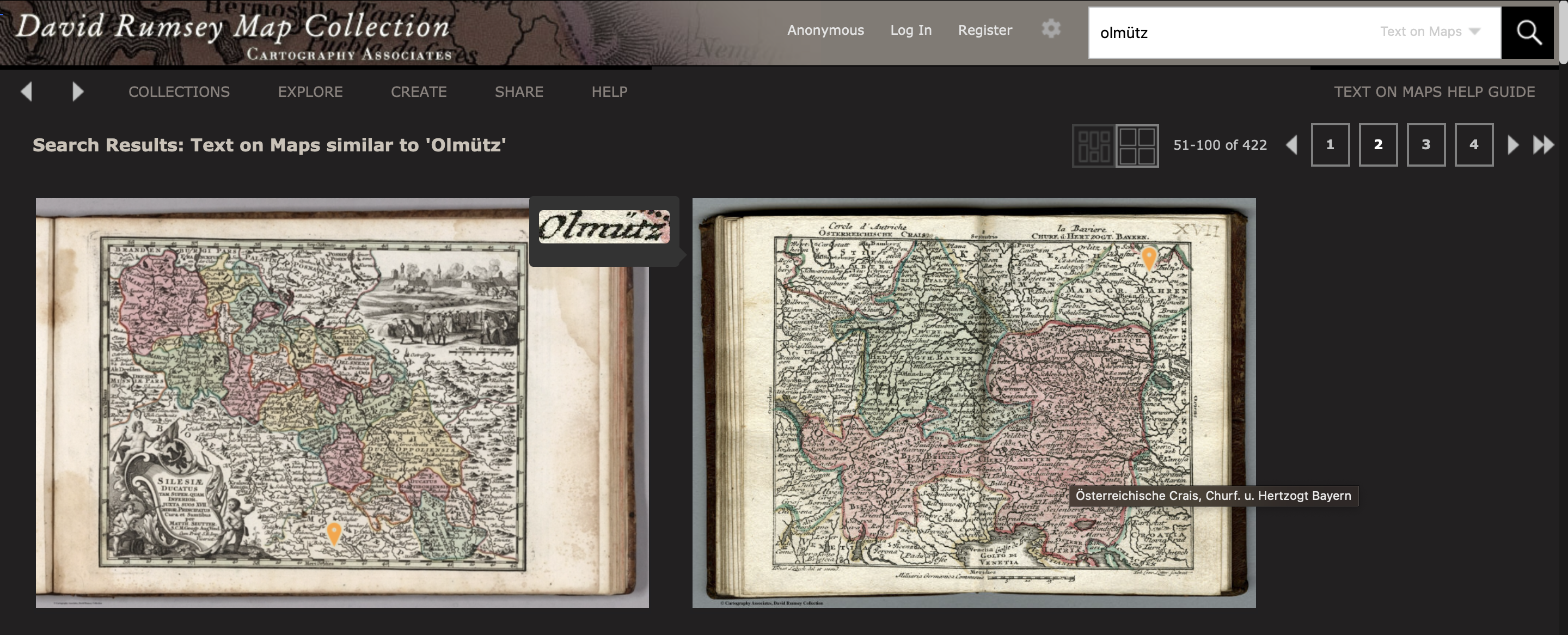
David Rumsey Historical Map Collection je jedna z největší soukromých sbírek historickým map, která obsahuje přes 150 tis záznamů. Její majitel (David Rumsey) nyní na Twitteru (nově síť X) oznámil, že indexovali 100 milionů geografických názvů na 57 tisíci mapách. Což znamená, že můžete vyhledávat v geografických názvech na jednotlivých mapách. Například při zadání pojmu […]
The post Obrovský průlom pro zájemce o staré mapy appeared first on GISportal.cz.
Obrovský průlom pro zájemce o staré mapy
31.8.2023 14:54 GISportal.czDavid Rumsey Historical Map Collection je jedna z největší soukromých sbírek historickým map, která obsahuje přes 150 tis záznamů. Její majitel (David Rumsey) nyní na Twitteru (nově síť X) oznámil, že indexovali 100 milionů geografických názvů na 57 tisíci mapách. Což znamená, že můžete vyhledávat v geografických názvech na jednotlivých mapách. Například při zadání pojmu […]
The post Obrovský průlom pro zájemce o staré mapy appeared first on GISportal.cz.
20230901 - volné místo - Rada/odborný rada v OMaK na KÚ pro ÚK
31.8.2023 13:29 ČÚZK /Urady/Katastralni-urady/Katastralni-urady/Katastralni-urad-pro-Ustecky-kraj/O-uradu/Aktuality/20230901-volne-misto-Rada-odborny-rada-v-OMaK-na-K20230901 - volné místo - Rada/odborný rada v OMaK na KÚ pro ÚK
31.8.2023 13:29 ČÚZK - předpisy a opatření Katastrální úřad pro Ústecký kraj zveřejnil novou aktualitu: Nabídka volného místa - Rada / odborný rada v oddělení metodiky a kontroly kanceláře ředitele katastrálního úřadu na Katastrálním úřadu pro Ústecký krajRada / odborný rada v oddělení metodiky a kontroly ředitele kanceláře katastrálního úřadu na Katastr
31.8.2023 13:23 ČÚZK - předpisy a opatření Katastrální úřad pro Ústecký kraj kancelář ředitelevypisuje výběrové řízení na místo
Rada / odborný rada v oddělení metodiky a kontroly ředitele kanceláře katastrálního úřadu na Katastrálním úřadu pro Ústecký kraj
Rada / odborný rada v oddělení metodiky a kontroly ředitele kanceláře katastrálního úřadu na Katastr
31.8.2023 13:23 ČÚZK - volná místa Katastrální úřad pro Ústecký kraj kancelář ředitele vypisuje výběrové řízení na místo Rada / odborný rada v oddělení metodiky a kontroly ředitele kanceláře katastrálního úřadu na KatastrRada / odborný rada v oddělení metodiky a kontroly ředitele kanceláře katastrálního úřadu na Katastr
31.8.2023 13:23 ČÚZK /Urady/Katastralni-urady/Katastralni-urady/Katastralni-urad-pro-Ustecky-kraj/Uredni-deska/Oznameni-a-jina-uredni-sdeleni/Volna-mista/DMS/Rada-odborny-rada-v-oddeleni-metodiky-a-kontroly-rNovinka – SLAM skener
31.8.2023 10:05 GeotronicsSlamový 3D skener Emesent Hovermap v české premiéře.
The post Novinka – SLAM skener first appeared on GEOTRONICS Praha.
Novinka – SLAM skener
31.8.2023 10:05 GeotronicsSlamový 3D skener Emesent Hovermap v české premiéře.
The post Novinka – SLAM skener first appeared on GEOTRONICS Praha.
Arkance Systems partnerem konference IFMA - automatizace FM s využitím BIM
31.8.2023 10:00 GIS FórumKDirSign v.5.0
31.8.2023 8:05 ČÚZK /Zememerictvi/Zememericke-cinnosti/Aktuality-pro-zememerice/2023/KDirSign-v-5-0KDirSign v.5.0
31.8.2023 8:05 ČÚZK - RSS kanál pro zeměměřiče V záložce Ověřování výsledků zeměměřických činností v elektronické podobě je ke stažení vystavena nová verze programu KDirSign 5.0, která zohledňuje zejm. změny vyvolané novelou zákona č. 200/1994 Sb., o zeměměřictví a o změně a doplnění některých zákonů souvisejících s jeho zavedením.KDirSign v.5.0
31.8.2023 8:05 ČÚZK - RSS kanál pro zeměměřiče V záložce Ověřování výsledků zeměměřických činností v elektronické podobě je ke stažení vystavena nová verze programu KDirSign 5.0, která zohledňuje zejm. změny vyvolané novelou zákona č. 200/1994 Sb., o zeměměřictví a o změně a doplnění některých zákonů souvisejících s jeho zavedením.KDirSign v.5.0
31.8.2023 8:05 ČÚZK - předpisy a opatření Český úřad zeměměřický a katastrální zveřejnil novou aktualitu: V záložce Ověřování výsledků zeměměřických činností v elektronické podobě je ke stažení vystavena nová verze programu KDirSign 5.0, která zohledňuje zejm. změny vyvolané novelou zákona č. 200/1994 Sb., o zeměměřictví a o změně a doplnění některých zákonů souvisejících s jeho zavedením.Nové letecké snímky v aplikaci Archiv
31.8.2023 8:00 ČÚZK - Geoportál Nové letecké snímky v aplikaci ArchivAplikace Archiv byla doplněna o nově naskenované archivní letecké měřické snímky z let 1974, 1993 a 1994.
Nové letecké snímky v aplikaci Archiv
31.8.2023 8:00 ČÚZK - Geoportál Nové letecké snímky v aplikaci ArchivAplikace Archiv byla doplněna o nově naskenované archivní letecké měřické snímky z let 1974, 1993 a 1994.
Nové letecké snímky v aplikaci Archiv
31.8.2023 8:00 ČÚZK - Geoportál Nové letecké snímky v aplikaci ArchivAplikace Archiv byla doplněna o nově naskenované archivní letecké měřické snímky z let 1974, 1993 a 1994.
Nové letecké snímky v aplikaci Archiv
31.8.2023 8:00 ČÚZK - Geoportál Nové letecké snímky v aplikaci ArchivAplikace Archiv byla doplněna o nově naskenované archivní letecké měřické snímky z let 1974, 1993 a 1994.
Nové letecké snímky v aplikaci Archiv
31.8.2023 8:00 ČÚZK - Geoportál Nové letecké snímky v aplikaci ArchivAplikace Archiv byla doplněna o nově naskenované archivní letecké měřické snímky z let 1974, 1993 a 1994.
Nové letecké snímky v aplikaci Archiv
31.8.2023 8:00 ČÚZK - Geoportál Nové letecké snímky v aplikaci ArchivAplikace Archiv byla doplněna o nově naskenované archivní letecké měřické snímky z let 1974, 1993 a 1994.
Nové letecké snímky v aplikaci Archiv
31.8.2023 8:00 ČÚZK - Geoportál Nové letecké snímky v aplikaci ArchivAplikace Archiv byla doplněna o nově naskenované archivní letecké měřické snímky z let 1974, 1993 a 1994.
Nové letecké snímky v aplikaci Archiv
31.8.2023 8:00 ČÚZK - Geoportál Nové letecké snímky v aplikaci ArchivAplikace Archiv byla doplněna o nově naskenované archivní letecké měřické snímky z let 1974, 1993 a 1994.
Nové letecké snímky v aplikaci Archiv
31.8.2023 8:00 ČÚZK - Geoportál Nové letecké snímky v aplikaci ArchivAplikace Archiv byla doplněna o nově naskenované archivní letecké měřické snímky z let 1974, 1993 a 1994.
Nové letecké snímky v aplikaci Archiv
31.8.2023 8:00 ČÚZK - Geoportál Nové letecké snímky v aplikaci ArchivAplikace Archiv byla doplněna o nově naskenované archivní letecké měřické snímky z let 1974, 1993 a 1994.
Nové letecké snímky v aplikaci Archiv
31.8.2023 8:00 ČÚZK - Geoportál Nové letecké snímky v aplikaci ArchivAplikace Archiv byla doplněna o nově naskenované archivní letecké měřické snímky z let 1974, 1993 a 1994.
Nové letecké snímky v aplikaci Archiv
31.8.2023 8:00 ČÚZK - Geoportál Nové letecké snímky v aplikaci ArchivAplikace Archiv byla doplněna o nově naskenované archivní letecké měřické snímky z let 1974, 1993 a 1994.
Nové letecké snímky v aplikaci Archiv
31.8.2023 8:00 ČÚZK - Geoportál Nové letecké snímky v aplikaci ArchivAplikace Archiv byla doplněna o nově naskenované archivní letecké měřické snímky z let 1974, 1993 a 1994.
Nové letecké snímky v aplikaci Archiv
31.8.2023 8:00 ČÚZK - Geoportál Nové letecké snímky v aplikaci ArchivAplikace Archiv byla doplněna o nově naskenované archivní letecké měřické snímky z let 1974, 1993 a 1994.
Nové letecké snímky v aplikaci Archiv
31.8.2023 8:00 ČÚZK - Geoportál Nové letecké snímky v aplikaci ArchivAplikace Archiv byla doplněna o nově naskenované archivní letecké měřické snímky z let 1974, 1993 a 1994.
Nové letecké snímky v aplikaci Archiv
31.8.2023 8:00 ČÚZK - Geoportál Nové letecké snímky v aplikaci ArchivAplikace Archiv byla doplněna o nově naskenované archivní letecké měřické snímky z let 1974, 1993 a 1994.
Nové letecké snímky v aplikaci Archiv
31.8.2023 8:00 ČÚZK - Geoportál Nové letecké snímky v aplikaci ArchivAplikace Archiv byla doplněna o nově naskenované archivní letecké měřické snímky z let 1974, 1993 a 1994.
Nové letecké snímky v aplikaci Archiv
31.8.2023 8:00 ČÚZK - Geoportál Nové letecké snímky v aplikaci ArchivAplikace Archiv byla doplněna o nově naskenované archivní letecké měřické snímky z let 1974, 1993 a 1994.
Nové letecké snímky v aplikaci Archiv
31.8.2023 8:00 ČÚZK - Geoportál Nové letecké snímky v aplikaci ArchivAplikace Archiv byla doplněna o nově naskenované archivní letecké měřické snímky z let 1974, 1993 a 1994.
Nové letecké snímky v aplikaci Archiv
31.8.2023 8:00 ČÚZK - Geoportál Nové letecké snímky v aplikaci ArchivAplikace Archiv byla doplněna o nově naskenované archivní letecké měřické snímky z let 1974, 1993 a 1994.
Nové letecké snímky v aplikaci Archiv
31.8.2023 8:00 ČÚZK - Geoportál Nové letecké snímky v aplikaci ArchivAplikace Archiv byla doplněna o nově naskenované archivní letecké měřické snímky z let 1974, 1993 a 1994.
Nové letecké snímky v aplikaci Archiv
31.8.2023 8:00 ČÚZK - Geoportál Nové letecké snímky v aplikaci ArchivAplikace Archiv byla doplněna o nově naskenované archivní letecké měřické snímky z let 1974, 1993 a 1994.
Nové letecké snímky v aplikaci Archiv
31.8.2023 8:00 ČÚZK - Geoportál Nové letecké snímky v aplikaci ArchivAplikace Archiv byla doplněna o nově naskenované archivní letecké měřické snímky z let 1974, 1993 a 1994.
Nové letecké snímky v aplikaci Archiv
31.8.2023 8:00 ČÚZK - Geoportál Nové letecké snímky v aplikaci ArchivAplikace Archiv byla doplněna o nově naskenované archivní letecké měřické snímky z let 1974, 1993 a 1994.