


![]()

zprávy
zdroje zpráv:Přes 30 miliónů symbolů pro CAD
28.1.2023 17:34 ŠPINAR - softwareVážení zákazníci,
dovolujeme si vám nabídnout program CAD Symbols v16 s ohromnou databází přes 30 milionů CAD symbolů ve 2D a 3D, které jednoduše vyhledáte a vložíte do svého CAD programu
The post Přes 30 miliónů symbolů pro CAD appeared first on ŠPINAR – software.
Přes 30 miliónů symbolů pro CAD
28.1.2023 17:34 ŠPINAR - software Vážení zákazníci,dovolujeme si vám nabídnout program CAD Symbols v16 s ohromnou databází přes 30 milionů CAD symbolů ve 2D a 3D, které jednoduše vyhledáte a vložíte do svého CAD programu
Přes 30 miliónů symbolů pro CAD
28.1.2023 17:34 ŠPINAR - softwareVážení zákazníci,
dovolujeme si vám nabídnout program CAD Symbols v16 s ohromnou databází přes 30 milionů CAD symbolů ve 2D a 3D, které jednoduše vyhledáte a vložíte do svého CAD programu
The post Přes 30 miliónů symbolů pro CAD appeared first on ŠPINAR – software.
Iceberg larger than London breaks off Brunt
27.1.2023 15:00 ESA Observing the Earth Video:
00:04:25
Video:
00:04:25
An iceberg around the size of Greater London broke off Antarctica’s Brunt Ice Shelf due to a natural process called ‘calving’. The iceberg, measuring 1550 sq km, detached from the 150 m-thick ice shelf a decade after scientists first spotted massive cracks in the shelf.
For more information on the newly-birthed A81 iceberg, click here.
EUSPA Multiannual Work Programme 2021-2027
27.1.2023 12:59 European GNSS Agency EUSPA Multiannual Work Programme 2021-2027 Mante.STASIULYTEEUSPA Multiannual Work Programme 2021-2027
27.1.2023 12:59 European GNSS Agency EUSPA Multiannual Work Programme 2021-2027 Mante.STASIULYTEZveřejnění obsahu informací poskytnutých na žádost dle zákona č. 106/1999 Sb. za rok 2023
27.1.2023 12:52 ČÚZK /Urady/Katastralni-urady/Katastralni-urady/Katastralni-urad-pro-Jihomoravsky-kraj/Casto-hledane-informace/Poskytovani-informaci-106-1999-Sb/Zverejneni-obsahu-informaci-poskytnutych-na-za-(1)/Zverejneni-obsahu-informaci-poskytnutych-na-za-(5)Zveřejnění obsahu informací poskytnutých na žádost dle zákona č. 106/1999 Sb. za rok 2023
27.1.2023 12:52 ČÚZK - předpisy a opatření Katastrální úřad pro Jihomoravský krajzveřejňuje obsah informace poskytnutých na žádost dle zákona č. 106/1999 Sb. za rok
2023
vrchní referent/rada - správa dokumentace katastru - informatik v oddělení dokumentace KN Katastráln
27.1.2023 9:57 ČÚZK - předpisy a opatření Katastrální úřad pro Jihočeský kraj Katastrální pracoviště Strakonicevypisuje výběrové řízení na místo
vrchní referent/rada - správa dokumentace katastru - informatik v oddělení dokumentace KN Katastrálního pracoviště Strakonice
vrchní referent/rada - správa dokumentace katastru - informatik v oddělení dokumentace KN Katastráln
27.1.2023 9:57 ČÚZK /Urady/Katastralni-urady/Katastralni-urady/Katastralni-urad-pro-Jihocesky-kraj/Uredni-deska/Oznameni-a-jina-uredni-sdeleni/Volna-mista/DMS/vrchni-referent-rada-sprava-dokumentace-katastru-ivrchní referent/rada - správa dokumentace katastru - informatik v oddělení dokumentace KN Katastráln
27.1.2023 9:57 ČÚZK - volná místa Katastrální úřad pro Jihočeský kraj Katastrální pracoviště Strakonice vypisuje výběrové řízení na místo vrchní referent/rada - správa dokumentace katastru - informatik v oddělení dokumentace KN Katastráln20230127
27.1.2023 9:45 ČÚZK - předpisy a opatření Český úřad zeměměřický a katastrální zveřejnil novou aktualitu: Zkoušky ÚOZI se budou konat ve dnech 15. a 16. února 2023.20230127
27.1.2023 9:45 ČÚZK - aktuality v resortu Zkoušky ÚOZI se budou konat ve dnech 15. a 16. února 2023.8. jednání TPS
27.1.2023 9:14 ČÚZK - předpisy a opatření Dne 8. března 2023 proběhne distančně 8. jednání Technické pracovní skupiny Koordinační rady správců DMVS a DTM.24. jednání KRS
27.1.2023 9:12 ČÚZK - předpisy a opatření Dne 22. února 2023 proběhne distančně 24. jednání Koordinační rady správců DMVS a DTM.odborný/vrchní referent - personalista/ka v kanceláři ředitele Katastrálního úřadu pro Jihočeský kra
27.1.2023 9:06 ČÚZK /Urady/Katastralni-urady/Katastralni-urady/Katastralni-urad-pro-Jihocesky-kraj/Uredni-deska/Oznameni-a-jina-uredni-sdeleni/Volna-mista/DMS/odborny-vrchni-referent-personalista-ka-v-kancelarodborný/vrchní referent - personalista/ka v kanceláři ředitele Katastrálního úřadu pro Jihočeský kra
27.1.2023 9:06 ČÚZK - volná místa Katastrální úřad pro Jihočeský kraj kancelář ředitele vypisuje výběrové řízení na místo odborný/vrchní referent - personalista/ka v kanceláři ředitele Katastrálního úřadu pro Jihočeský kraodborný/vrchní referent - personalista/ka v kanceláři ředitele Katastrálního úřadu pro Jihočeský kra
27.1.2023 9:06 ČÚZK - předpisy a opatření Katastrální úřad pro Jihočeský kraj kancelář ředitelevypisuje výběrové řízení na místo
odborný/vrchní referent - personalista/ka v kanceláři ředitele Katastrálního úřadu pro Jihočeský kraj (ID SM 30000022/30003646)
Radar images capture new Antarctic mega-iceberg
26.1.2023 16:27 ESA Observing the Earth Video:
00:00:23
Video:
00:00:23
Using radar images from the Copernicus Sentinel-1 mission, the animation shows the A81 iceberg breaking away from the Brunt Ice Shelf on 25 January 2023. The new berg is estimated to be around 1550 sq km, which is around the size of Greater London, and is approximately 150 m thick. It calved when the crack known as Chasm-1 split northwards severing the west part of the ice shelf.
The white square indicated the final breakpoint near the McDonald Ice Rumples.
Routine monitoring from satellites offers unparalleled views of events happening in remote regions. The Copernicus Sentinel-1 mission carries radar, which can return images regardless of day or night and this allows us year-round viewing, which is especially important through the long, dark, austral winter months.
Read the full story: Giant iceberg breaks away from Antarctic ice shelf
Leica Tour 2023
26.1.2023 14:49 ZeměměřičSpolečnost GEFOS zve na svoji letošní Leica Tour, na které představí novinky z portfolia měřické techniky Leica Geosystems. Akce se uskuteční od 6. do 16. března celkem v osmi městech. Vstup na akci je pro všechny zájemce zdarma. Pro lepší plánování kapacit vás organizátoři prosí, zda byste si vybrali město, ve kterém se budete chtít Leica Tour 2023 zúčastnit. […]
The post Leica Tour 2023 appeared first on Zeměměřič.
Součástí Geodézie ve stavebnictví a průmyslu bude také vysvětlení České komory zeměměřičů
26.1.2023 12:30 ZeměměřičČeský svaz geodetů a kartografů pořádá další ročník akce Geodézie ve stavebnictví a průmyslu, která se uskuteční v Brně 1. března 2023. Program Geodézie ve stavebnictví a průmyslu První blok 9:30 – 11:00 Jiří Bureš (VUT v Brně, OS-IG Český svaz geodetů a kartografů): Činnost odborné skupiny Inženýrské geodézie při ČSGK Pavel Roubal (Správa železnic): Správa prostorové polohy koleje ve vztahu k BIM a DTM […]
The post Součástí Geodézie ve stavebnictví a průmyslu bude také vysvětlení České komory zeměměřičů appeared first on Zeměměřič.
Součástí programu akce Geodézie ve stavebnictví a průmyslu bude také vysvětlení právní úpravy České komory zeměměřičů
26.1.2023 12:30 ZeměměřičČeský svaz geodetů a kartografů pořádá další ročník akce Geodézie ve stavebnictví a průmyslu, která se uskuteční v Brně 1. března 2023. Program Geodézie ve stavebnictví a průmyslu První blok 9:30 – 11:00 Jiří Bureš (VUT v Brně, OS-IG Český svaz geodetů a kartografů): Činnost odborné skupiny Inženýrské geodézie při ČSGK Pavel Roubal (Správa železnic): Správa prostorové polohy koleje ve vztahu k BIM a DTM […]
The post Součástí programu akce Geodézie ve stavebnictví a průmyslu bude také vysvětlení právní úpravy České komory zeměměřičů appeared first on Zeměměřič.
personalista Katastrálního úřadu pro Pardubický kraj
26.1.2023 10:42 ČÚZK - předpisy a opatření Katastrální úřad pro Pardubický krajvypisuje výběrové řízení na místo
personalista Katastrálního úřadu pro Pardubický kraj
personalista Katastrálního úřadu pro Pardubický kraj
26.1.2023 10:42 ČÚZK - volná místa Katastrální úřad pro Pardubický kraj vypisuje výběrové řízení na místo personalista Katastrálního úřadu pro Pardubický krajpersonalista Katastrálního úřadu pro Pardubický kraj
26.1.2023 10:42 ČÚZK /Urady/Katastralni-urady/Katastralni-urady/Katastralni-urad-pro-Pardubicky-kraj/Uredni-deska/Oznameni-a-jina-uredni-sdeleni/Volna-mista/DMS/Oznameni-o-vyhlaseni-vyberoveho-rizeni-na-sluzebniGiant iceberg breaks away from Antarctic ice shelf
25.1.2023 15:45 ESA Observing the Earth
Satellite imagery confirms an enormous iceberg, around five times the size of Malta, has finally calved from Antarctica’s Brunt Ice Shelf. The new berg, estimated to be around 1550 sq km and around 150 m thick, calved when the crack known as Chasm-1 fully extended northwards severing the west part of the ice shelf.
This crack was first revealed to be extending in early 2012 after having been dormant for some decades. After several years of desperately clinging on, image data from the Copernicus Sentinel missions visually confirm the calving event.
Česká komora zeměměřičů schválena. Poslanci ve třetím odhlasovali novelu zákona o zeměměřictví
25.1.2023 15:34 ZeměměřičNa svém zasedání 25. ledna 2023 poslanecká sněmovna schválila novelu zákona o zeměměřictví včetně pozměňovacího návrhu, jímž se do tohoto zákona s účinností od 1. července 2023 zavádí Česká komora zeměměřičů. Teď je na řadě vyjednání podpory zákona v senátu. Na webu poslanecké sněmovny je hlasování vedeno jako bod 91 v jednání následovně: Vládní návrh zákona, kterým se mění zákon č. 200/1994 […]
The post Česká komora zeměměřičů schválena. Poslanci ve třetím odhlasovali novelu zákona o zeměměřictví appeared first on Zeměměřič.
Česká komora zeměměřičů vznikne k 1. červenci letošního roku. Poslanci schválili novelu zákona o zeměměřictví
25.1.2023 15:34 ZeměměřičNa svém zasedání 25. ledna 2023 poslanecká sněmovna schválila novelu zákona o zeměměřictví včetně pozměňovacího návrhu, jímž se do tohoto zákona s účinností od 1. července 2023 zavádí Česká komora zeměměřičů. Na webu poslanecké sněmovny je hlasování vedeno jako bod 91 v jednání následovně: Vládní návrh zákona, kterým se mění zákon č. 200/1994 Sb., o zeměměřictví a o změně a doplnění některých zákonů souvisejících s jeho […]
The post Česká komora zeměměřičů vznikne k 1. červenci letošního roku. Poslanci schválili novelu zákona o zeměměřictví appeared first on Zeměměřič.
20230125_Odborný referent oddělení právních vztahů k nemovitostem
25.1.2023 12:57 ČÚZK - předpisy a opatření Katastrální úřad pro Středočeský kraj - Katastrální pracoviště Slaný Vyhlášení výběrového řízení: Odborný referent oddělení právních vztahů k nemovitostem V části "Úřední deska", v sekci "Oznámení a jiná úřední sdělení" bylo vystaveno "Oznámení o vyhlášení výběrového řízení na obsazení služebního místa Odborný referent oddělení právních vztahů k nemovitostem"20230125_Odborný referent oddělení právních vztahů k nemovitostem
25.1.2023 12:57 ČÚZK /Urady/Katastralni-urady/Katastralni-urady/Katastralni-urad-pro-Stredocesky-kraj/Katastralni-pracoviste/KP-Slany/O-uradu/Aktuality/20230111_Odborny-rada-oddeleni-pravnich-vztahu-k-nOdborný referent oddělení právních vztahů k nemovitostem
25.1.2023 12:56 ČÚZK - volná místa Katastrální úřad pro Středočeský kraj Katastrální pracoviště Slaný vypisuje výběrové řízení na místo Odborný referent oddělení právních vztahů k nemovitostemOdborný referent oddělení právních vztahů k nemovitostem
25.1.2023 12:56 ČÚZK - předpisy a opatření Katastrální úřad pro Středočeský kraj Katastrální pracoviště Slanývypisuje výběrové řízení na místo
Odborný referent oddělení právních vztahů k nemovitostem
EU Space helps drive the green transformation
25.1.2023 10:36 European GNSS Agency
Climate change is one of the biggest challenges facing humanity today. Overcoming it requires a green transformation – one characterised by a drastic reduction in carbon emissions and a significant increase in sustainable best practices.
Driving this transformation is the European Green Deal, which strives to make Europe the world’s first climate-neutral continent by 2050. But to achieve this goal, companies must take a deep look at their internal operations, as well as their supply chains, to identify opportunities for reducing their own environmental footprint.
This is where EU Space comes into play.
The EU Space Programme, including Copernicus, Galileo and EGNOS, can play a critical role in supplying the information companies need to monitor environmental indicators, reduce their environmental impact, become more sustainable and drive the green transformation.
“EU Space data and services are an important asset to support the implementation of the Green Deal,” says EUSPA Executive Director Rodrigo da Costa. “Businesses in particular stand to benefit from a myriad of possible applications for EU Space data, which translates into greener practices, cost reductions and increased efficiency.”
EU Space for Green Transformation, a new report by EUSPA, introduces the Green Deal and its implications for companies. It also presents detailed examples of how various industries, including energy, road transport, aviation, agriculture, forestry and mining, are leveraging the power of EU Space to drive their sustainability journeys.
EU Space data supports the shift to renewable energy
According to the Report, the EU Space Programme is set to support the energy sector’s shift from fossil fuels to renewables – a process that starts with site selection.
Choosing the right location for renewable energy infrastructure is a key prerequisite to efficient energy production. Connections to the grid, historical weather data (solar irradiance, windspeeds and directions, marine currents, etc.), as well as oro- and topographical characteristics, are all crucial parameters in this process.
EU Space data makes finding the optimal site easier. For example, using information gathered from Copernicus’ satellites and atmospheric models, the Copernicus Atmosphere Monitoring Service produces global irradiation models that the renewable energy sector can use to make informed decisions on where to best place solar panels. Considering Copernicus’ ability to monitor wind and marine currents, similar applications can be used to optimise the location of wind turbines and tidal power generation plants.
EU Space offers substantial environmental benefits
Once the infrastructure is built and operational, it must be maintained – something that becomes all the more challenging when the solar panels and wind turbines are located in difficult-to-reach and remote locations.
Here too EU Space can help.
The precise positioning services offered by Galileo and EGNOS, together with the latest developments in computer vision-aided navigation, enable the use of unmanned aerial vehicles (UAVs), or drones, to efficiently, effectively and safely inspect renewable energy infrastructure.
GNSS-enabled drones are already used to remotely detect solar panel hotspots, which can reduce power generation, and inspect wind turbine structures. With the forthcoming Galileo High Accuracy Service, this capability will become even more efficient and widespread.
“Whether it be increasing the efficiency of renewable energy infrastructure, enabling more efficient flightpaths or implementing precision agriculture operations, as this Report makes clear, the cumulative environmental benefits enabled by the EU Space Programme are simply substantial,” concludes da Costa.
To learn how your company’s sustainability journey can benefit from EU Space data and services, download the full EU Space for Green Transformation report here. Or contact us at market@euspa.europa.eu.
Media note: This feature can be republished without charge provided the European Union Agency for the Space Programme (EUSPA) is acknowledged as the source at the top or the bottom of the story. You must request permission before you use any of the photographs on the site. If you republish, we would be grateful if you could link back to the EUSPA website (http://www.euspa.europa.eu).
Již skoro rok pomáháme Ukrajině
25.1.2023 10:23 Hrdlička K ruské agresi nejsme lhostejní a přicházíme s projekty na podporu Ukrajiny.obnova katastrálního operátu v oddělení aktualizace KN Katastrálního pracoviště Strakonice (ID SM 30
25.1.2023 9:58 ČÚZK - předpisy a opatření Katastrální úřad pro Jihočeský kraj Katastrální pracoviště Strakonicevypisuje výběrové řízení na místo
obnova katastrálního operátu v oddělení aktualizace KN Katastrálního pracoviště Strakonice (ID SM 30000296/30003920)
Výběrové řízení na pozici rada / odborný rada - vedoucí oddělení ICT technického útvaru Katastrálníh
25.1.2023 6:22 ČÚZK /Urady/Katastralni-urady/Katastralni-urady/Katastralni-urad-pro-Kralovehradecky-kraj/Uredni-deska/Oznameni-a-jina-uredni-sdeleni/Volna-mista/DMS/Vyberove-rizeni-na-pozici-rada-odborny-rada-vedoucVýběrové řízení na pozici rada / odborný rada - vedoucí oddělení ICT technického útvaru Katastrálníh
25.1.2023 6:22 ČÚZK - volná místa Katastrální úřad pro Královéhradecký kraj technický útvar vypisuje výběrové řízení na místo Výběrové řízení na pozici rada / odborný rada - vedoucí oddělení ICT technického útvaru KatastrálníhVýběrové řízení na pozici rada / odborný rada - vedoucí oddělení ICT technického útvaru Katastrálníh
25.1.2023 6:22 ČÚZK - předpisy a opatření Katastrální úřad pro Královéhradecký kraj technický útvarvypisuje výběrové řízení na místo
Výběrové řízení na pozici rada / odborný rada - vedoucí oddělení ICT technického útvaru Katastrálního úřadu pro Královéhradecký kraj
APGEO - Poslanecká sněmovna schválila novelu zákona o zeměměřictví
25.1.2023 1:00 Asociace podnikatelů v geomatice PSP ČR schválila novelu zákona o zeměměřictví včetně PN, kterým se ustanovuje Česká komora zeměměřičů.New Galileo service set to deliver 20 cm accuracy
24.1.2023 15:41 ESA Navigation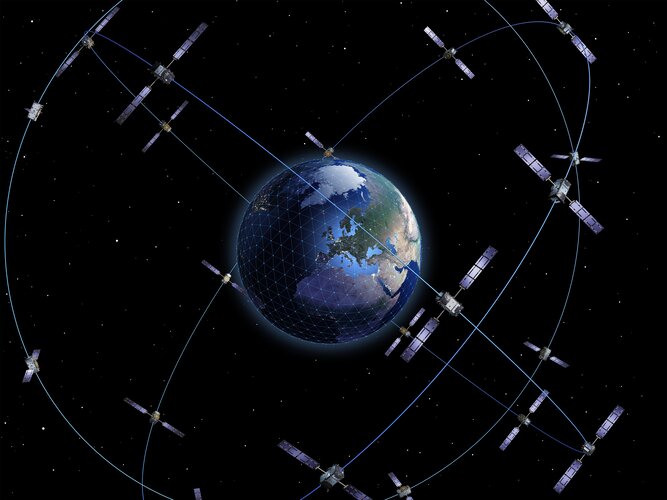
Galileo’s capabilities have grown with the addition of a new High Accuracy Service, freely available worldwide to anyone with a suitably equipped receiver. Delivering horizontal accuracy down to 20 cm and vertical accuracy of 40 cm, the High Accuracy Service is enabled through an additional level of real-time positioning corrections, delivered through a new data stream within the existing Galileo signal.
20230124_Vrchní referent / rada oddělení obnovy a revize KN
24.1.2023 14:51 ČÚZK /Urady/Katastralni-urady/Katastralni-urady/Katastralni-urad-pro-Stredocesky-kraj/Katastralni-pracoviste/KP-Praha-zapad/O-uradu/Aktuality/20210922_Odborny-referent-oddeleni-aktualizac-(2)20230124_Vrchní referent / rada oddělení obnovy a revize KN
24.1.2023 14:51 ČÚZK - předpisy a opatření Katastrální úřad pro Středočeský kraj - Katastrální pracoviště Praha-západ Vyhlášení výběrového řízení: Vrchní referent / rada oddělení obnovy a revize KN V části "Úřední deska", v sekci "Oznámení a jiná úřední sdělení" bylo vystaveno "Oznámení o vyhlášení výběrového řízení na obsazení služebního místa Vrchní referent / rada oddělení obnovy a revize KN"Vrchní referent / rada oddělení obnovy a revize KN
24.1.2023 14:49 ČÚZK - předpisy a opatření Katastrální úřad pro Středočeský kraj Katastrální pracoviště Praha-západvypisuje výběrové řízení na místo
Vrchní referent / rada oddělení obnovy a revize KN
Vrchní referent / rada oddělení obnovy a revize KN
24.1.2023 14:49 ČÚZK - volná místa Katastrální úřad pro Středočeský kraj Katastrální pracoviště Praha-západ vypisuje výběrové řízení na místo Vrchní referent / rada oddělení obnovy a revize KNVýběrové řízení
24.1.2023 14:32 ČÚZK - předpisy a opatření Katastrální úřad pro Plzeňský kraj - Katastrální pracoviště Klatovy zveřejnil novou aktualitu: Ředitelka Katastrálního úřadu pro Plzeňský kraj jako služební orgán příslušný podle § 10 odst. 1 písm. f) zákona č. 234/2014 Sb., o státní službě, ve znění pozdějších předpisů, vyhlašuje výběrové řízení na služební místo odborný/vrchní referent – zápisy v řízení V a Z – ZRVZ0601, na Katastrálním úřadu pro Plzeňský kraj, oddělení právních vztahů k nemovitostem, na Katastrálním pracovišti Klatovy, se služebním působištěm v Klatovech. Na služebním místě je státní služba vykonávána v oboru služby 55. Zeměměřictví a katastr nemovitostí.Výběrové řízení na služební místo odborný/vrchní referent oddělení právních vztahů k nemovitostem, K
24.1.2023 14:27 ČÚZK - volná místa Katastrální úřad pro Plzeňský kraj Katastrální pracoviště Klatovy vypisuje výběrové řízení na místo Výběrové řízení na služební místo odborný/vrchní referent oddělení právních vztahů k nemovitostem, KVýběrové řízení na služební místo odborný/vrchní referent oddělení právních vztahů k nemovitostem, K
24.1.2023 14:27 ČÚZK - předpisy a opatření Katastrální úřad pro Plzeňský kraj Katastrální pracoviště Klatovyvypisuje výběrové řízení na místo
Výběrové řízení na služební místo odborný/vrchní referent oddělení právních vztahů k nemovitostem, Katastrální pracoviště Klatovy
Výběrové řízení na služební místo odborný/vrchní referent oddělení právních vztahů k nemovitostem, K
24.1.2023 14:27 ČÚZK /Urady/Katastralni-urady/Katastralni-urady/Katastralni-urad-pro-Plzensky-kraj/Uredni-deska/Oznameni-a-jina-uredni-sdeleni/Volna-mista/DMS/Vyberove-rizeni-na-sluzebni-misto-odborny-vrchni-rESA and the European Commission uniting on Earth observation for the Philippines
24.1.2023 14:00 ESA Observing the Earth
ESA and the European Commission have signed a contribution agreement to build a Copernicus mirror site in the Philippines – the first of its kind in southeast Asia. The new CopPhil initiative will enhance the response capability and resilience of the Philippines to natural and human made disasters through the strategic use of space data. This will help reduce vulnerability of the nation to climate hazards, support climate adaption, food security and environmental protection.
Galileo High Accuracy Service goes live!
24.1.2023 11:53 European GNSS Agency
Galileo, European Union Global Navigation Satellite System (GNSS), begins the delivery of its High Accuracy Service (HAS) today as officially announced by Thierry Breton, European Commissioner for Internal Market, “feeding a prosperous market for innovative applications – from farming to drone navigation and autonomous driving.”
Galileo is now the first Global Navigation Satellite System (GNSS) providing free-of-charge, high accuracy Precise Point Positioning (PPP) corrections worldwide both through the Galileo signal in space (E6-B) and via the internet.
The precise corrections provided by the Galileo HAS will allow users to improve the accuracy associated with the orbit, clocks and biases provided through the Galileo Open Service broadcast navigation messages and the GPS Standard Positioning Service navigation data. These corrections enable the computation of a high accuracy positioning solution in real-time when processed by an appropriate algorithm in the users’ receivers tracking the Galileo E6-B signal.
The typical accuracy below a few decimetres (<25cm horizontal) in nominal conditions of use is a revolution where Europe provides this as an integrated service for free, thus allowing the massive development of applications worldwide.
“This new service has been made possible thanks to the outstanding cooperation and team commitment of all involved partners” declared EUSPA Executive Director, Rodrigo da Costa.
“Galileo HAS will become the pillar of many EU sectorial policies. Currently, high accuracy is primarily used in such professional applications as surveying, precision agriculture and civil engineering, amongst others,” he says. “However, new and emerging applications, including autonomous driving, unmanned vehicles, robotics and a range of location-based services will all welcome high accuracy.”
Da Costa also notes that, when used in synergy with Copernicus, the Galileo HAS will open up new market possibilities and help design new services.
All official HAS documentation, including its Service Definition Document (SDD) are available in the European GNSS Service Center (E-GSC), managed by EUSPA.
The culmination of an ongoing process
In 2021, EUSPA published an Information Note on the Galileo HAS. The note provided an overview of the service’s main characteristics, along with information on such key features as targeted performance and markets, service levels and a roadmap for implementation.
External stakeholders participated in a testing campaign of the Galileo HAS Signal in Space broadcasting. Thus, relevant feedback has been collected not only on the HAS SiS Interface Control Document structure and implementation at the receiver level, but also on service-related aspects and specifications.
“The Galileo High Accuracy Service offers new levels of accuracy to everyone who needs it, while the Open Service Navigation Message Authentication allows users to authenticate Galileo signals, and therefore supports spoofing detection. ESA's role is to oversee Galileo system upgrades, working together with Galileo’s service provider, EUSPA, and its owner, the European Union”, remarks Javier Benedicto, ESA Director of Navigation.
“The Galileo programme has been performing a long set of HAS testing activities since 2019 leading to the first-ever HAS signal broadcast in May 2021,” adds Javier de Blas, EUSPA Commercial and HAS manager. “Based on the feedback gained during the joint efforts conducted by EUSPA, the European Commission and ESA, with the key support of the European aerospace industry during the testing phase, we were able to publish the first Galileo High Accuracy Service Signal in Space Interface Control Document and introduce the necessary changes to ensure the HAS Initial Service implements the feedback received from the users.”
Following the HAS Initial Service Declaration, the Galileo Programme will continue its efforts to incrementally improve its coverage and performance over the next years towards its Full-Service Declaration.
Media note: This feature can be republished without charge provided the European Union Agency for the Space Programme (EUSPA) is acknowledged as the source at the top or the bottom of the story. You must request permission before you use any of the photographs on the site. If you republish, we would be grateful if you could link back to the EUSPA website (http://www.euspa.europa.eu).
Galileo High Accuracy Service goes live!
24.1.2023 11:53 European GNSS Agency Galileo High Accuracy Service goes live!The Galileo High Accuracy Service (HAS) is now operational offering unprecedented accuracy for positioning.

The Galileo High Accuracy Service (HAS) is now operational offering unprecedented accuracy for positioning.
Galileo, European Union Global Navigation Satellite System (GNSS), begins the delivery of its High Accuracy Service (HAS) today as officially announced by Thierry Breton, European Commissioner for Internal Market, “feeding a prosperous market for innovative applications – from farming to drone navigation and autonomous driving.”
Galileo is now the first Global Navigation Satellite System (GNSS) providing free-of-charge, high accuracy Precise Point Positioning (PPP) corrections worldwide both through the Galileo signal in space (E6-B) and via the internet.
The precise corrections provided by the Galileo HAS will allow users to improve the accuracy associated with the orbit, clocks and biases provided through the Galileo Open Service broadcast navigation messages and the GPS Standard Positioning Service navigation data. These corrections enable the computation of a high accuracy positioning solution in real-time when processed by an appropriate algorithm in the users’ receivers tracking the Galileo E6-B signal.
The typical accuracy below a few decimetres (<25cm horizontal) in nominal conditions of use is a revolution where Europe provides this as an integrated service for free, thus allowing the massive development of applications worldwide.
“This new service has been made possible thanks to the outstanding cooperation and team commitment of all involved partners” declared EUSPA Executive Director, Rodrigo da Costa.
“Galileo HAS will become the pillar of many EU sectorial policies. Currently, high accuracy is primarily used in such professional applications as surveying, precision agriculture and civil engineering, amongst others,” he says. “However, new and emerging applications, including autonomous driving, unmanned vehicles, robotics and a range of location-based services will all welcome high accuracy.”
Da Costa also notes that, when used in synergy with Copernicus, the Galileo HAS will open up new market possibilities and help design new services.
All official HAS documentation, including its Service Definition Document (SDD) are available in the European GNSS Service Center (E-GSC), managed by EUSPA.
The culmination of an ongoing process
In 2021, EUSPA published an Information Note on the Galileo HAS. The note provided an overview of the service’s main characteristics, along with information on such key features as targeted performance and markets, service levels and a roadmap for implementation.
External stakeholders participated in a testing campaign of the Galileo HAS Signal in Space broadcasting. Thus, relevant feedback has been collected not only on the HAS SiS Interface Control Document structure and implementation at the receiver level, but also on service-related aspects and specifications.
“The Galileo High Accuracy Service offers new levels of accuracy to everyone who needs it, while the Open Service Navigation Message Authentication allows users to authenticate Galileo signals, and therefore supports spoofing detection. ESA's role is to oversee Galileo system upgrades, working together with Galileo’s service provider, EUSPA, and its owner, the European Union”, remarks Javier Benedicto, ESA Director of Navigation.
“The Galileo programme has been performing a long set of HAS testing activities since 2019 leading to the first-ever HAS signal broadcast in May 2021,” adds Javier de Blas, EUSPA Commercial and HAS manager. “Based on the feedback gained during the joint efforts conducted by EUSPA, the European Commission and ESA, with the key support of the European aerospace industry during the testing phase, we were able to publish the first Galileo High Accuracy Service Signal in Space Interface Control Document and introduce the necessary changes to ensure the HAS Initial Service implements the feedback received from the users.”
Following the HAS Initial Service Declaration, the Galileo Programme will continue its efforts to incrementally improve its coverage and performance over the next years towards its Full-Service Declaration.
Media note: This feature can be republished without charge provided the European Union Agency for the Space Programme (EUSPA) is acknowledged as the source at the top or the bottom of the story. You must request permission before you use any of the photographs on the site. If you republish, we would be grateful if you could link back to the EUSPA website (http://www.euspa.europa.eu).
Nabídka vozidla k bezúplatnému převodu pro OSS
24.1.2023 11:06 ČÚZK /Urady/Katastralni-urady/Katastralni-urady/Katastralni-urad-pro-Moravskoslezsky-kraj/Nabidky-majetku/Nabidka-vozidla-k-bezuplatnemu-prevodu-pro-OSSNabídka vozidla k bezúplatnému převodu pro OSS
24.1.2023 11:06 ČÚZK - předpisy a opatřeníKatastrální úřad pro Moravskoslezský kraj nabízí nepotřebný majetek k odkupu. Jedná se o
Nabídka vozidla k bezúplatnému převodu pro OSS
Praktické zkušenosti Prahy 2 s Analytickou mapou kriminality a více bezpečí pro obyvatele
24.1.2023 9:48 T-MAPYThe post Praktické zkušenosti Prahy 2 s Analytickou mapou kriminality a více bezpečí pro obyvatele appeared first on T-MAPY spol. s r.o..
Více bezpečí pro obyvatele. Praktické zkušenosti Prahy 2 s Analytickou mapou kriminality
24.1.2023 9:48 T-MAPYThe post Více bezpečí pro obyvatele. Praktické zkušenosti Prahy 2 s Analytickou mapou kriminality appeared first on T-MAPY spol. s r.o..
Více bezpečí pro obyvatele Prahy 2. Praktické zkušenosti s Analytickou mapou kriminality
24.1.2023 9:48 T-MAPYThe post Více bezpečí pro obyvatele Prahy 2. Praktické zkušenosti s Analytickou mapou kriminality appeared first on T-MAPY spol. s r.o..
Více bezpečí pro obyvatele Prahy 2. Praktické zkušenosti s Analytickou mapou kriminality
24.1.2023 9:48 T-MAPYThe post Více bezpečí pro obyvatele Prahy 2. Praktické zkušenosti s Analytickou mapou kriminality appeared first on T-MAPY spol. s r.o..
Praktické zkušenosti Prahy 2 s Analytickou mapou kriminality. Více bezpečí pro obyvatele
24.1.2023 9:48 T-MAPYThe post Praktické zkušenosti Prahy 2 s Analytickou mapou kriminality. Více bezpečí pro obyvatele appeared first on T-MAPY spol. s r.o..
Nedostupné produkční ISÚI a VDP
23.1.2023 15:01 ČÚZK /ruian/Editacni-agendovy-system-ISUI/Provozni-informace-a-odstavky/Archiv-PROD/Nedostupne-produkcni-ISUI-a-VDP-(3)odborný referent/vrchní referent – poskytování informací KN a PK, poskytování podkladů, nahlížení do
23.1.2023 14:59 ČÚZK - volná místa Katastrální úřad pro Olomoucký kraj Katastrální pracoviště Šumperk vypisuje výběrové řízení na místo odborný referent/vrchní referent – poskytování informací KN a PK, poskytování podkladů, nahlížení doodborný referent/vrchní referent – poskytování informací KN a PK, poskytování podkladů, nahlížení do
23.1.2023 14:59 ČÚZK /Urady/Katastralni-urady/Katastralni-urady/Katastralni-urad-pro-Olomoucky-kraj/Uredni-deska/Oznameni-a-jina-uredni-sdeleni/Volna-mista/DMS/odborny-referent-vrchni-referent-–-poskytovani-infodborný referent/vrchní referent – poskytování informací KN a PK, poskytování podkladů, nahlížení do
23.1.2023 14:59 ČÚZK - předpisy a opatření Katastrální úřad pro Olomoucký kraj Katastrální pracoviště Šumperkvypisuje výběrové řízení na místo
odborný referent/vrchní referent – poskytování informací KN a PK, poskytování podkladů, nahlížení do KN
rada/odborný rada – rozhodování o povolení vkladu
23.1.2023 14:56 ČÚZK - volná místa Katastrální úřad pro Olomoucký kraj Katastrální pracoviště Šumperk vypisuje výběrové řízení na místo rada/odborný rada – rozhodování o povolení vkladurada/odborný rada – rozhodování o povolení vkladu
23.1.2023 14:56 ČÚZK - předpisy a opatření Katastrální úřad pro Olomoucký kraj Katastrální pracoviště Šumperkvypisuje výběrové řízení na místo
rada/odborný rada – rozhodování o povolení vkladu
Informace o výsledcích kontrol dle § 26 zákona č. 255/2012 Sb. za rok 20
23.1.2023 11:18 ČÚZK - předpisy a opatření Zeměměřický a katastrální inspektorát v Českých Budějovicíchvydává informace o výsledcích kontrol dle § 26 zákona č. 255/2012 Sb. za rok
2022
odborný/vrchní referent - návrh zápisu v katastru v oddělení právních vztahů k nemovitostem Katastrá
23.1.2023 8:32 ČÚZK - volná místa Katastrální úřad pro Jihočeský kraj Katastrální pracoviště Jindřichův Hradec vypisuje výběrové řízení na místo odborný/vrchní referent - návrh zápisu v katastru v oddělení právních vztahů k nemovitostem Katastráodborný/vrchní referent - návrh zápisu v katastru v oddělení právních vztahů k nemovitostem Katastrá
23.1.2023 8:32 ČÚZK /Urady/Katastralni-urady/Katastralni-urady/Katastralni-urad-pro-Jihocesky-kraj/Uredni-deska/Oznameni-a-jina-uredni-sdeleni/Volna-mista/DMS/odborny-vrchni-referent-navrh-zapisu-v-katastru-v-odborný/vrchní referent - návrh zápisu v katastru v oddělení právních vztahů k nemovitostem Katastrá
23.1.2023 8:32 ČÚZK - předpisy a opatření Katastrální úřad pro Jihočeský kraj Katastrální pracoviště Jindřichův Hradecvypisuje výběrové řízení na místo
odborný/vrchní referent - návrh zápisu v katastru v oddělení právních vztahů k nemovitostem Katastrálního pracoviště Jindřichův Hradec (ID SM 30000372/30096704)
Systémový inženýr / systémová inženýrka
23.1.2023 7:52 ČÚZK - předpisy a opatření Zeměměřický úřadvypisuje výběrové řízení na místo
Systémový inženýr / systémová inženýrka
Systémový inženýr / systémová inženýrka
23.1.2023 7:52 ČÚZK /Urady/Zememericky-urad/Volna-mista/DMS/Systemovy-inzenyr-systemova-inzenyrkaSystémový inženýr / systémová inženýrka
23.1.2023 7:52 ČÚZK - volná místa Zeměměřický úřad vypisuje výběrové řízení na místo Systémový inženýr / systémová inženýrkaSystémový inženýr / systémová inženýrka
23.1.2023 7:52 Zeměměřický úřad Zeměměřický úřadvypisuje výběrové řízení na místo
Systémový inženýr / systémová inženýrka
Výroční zpráva dle zákona č. 106/1999 Sb. za rok 2022
23.1.2023 7:48 Zeměměřický úřad Zeměměřický úřadvydává výroční zprávu úřadu za rok
2022
Výroční zpráva dle zákona č. 106/1999 Sb. za rok 2022
23.1.2023 7:48 ČÚZK /Urady/Zememericky-urad/Zpravy-ZU/Vyrocni-zpravy-ZU-souhrne-informace/Vyrocni-zprava-dle-zakona-c-106-1999-Sb-za-rok-202Výroční zpráva dle zákona č. 106/1999 Sb. za rok 2022
23.1.2023 7:48 ČÚZK - předpisy a opatření Zeměměřický úřadvydává výroční zprávu úřadu za rok
2022
Informace o výsledcích kontrol dle § 26 zákona č. 255/2012 Sb. za rok 20
23.1.2023 7:12 ČÚZK - předpisy a opatření Zeměměřický a katastrální inspektorát v Brněvydává informace o výsledcích kontrol dle § 26 zákona č. 255/2012 Sb. za rok
2022
Výroční zpráva dle zákona č. 106/1999 Sb. za rok 2022 20
23.1.2023 7:09 ČÚZK - předpisy a opatření Zeměměřický a katastrální inspektorát v Brněvydává výroční zprávu úřadu za rok
2022
Výroční zpráva dle zákona č. 106/1999 Sb. za rok 2022 20
23.1.2023 7:09 ČÚZK /Urady/Zememericke-a-katastralni-inspektoraty/Zememericke-a-katastralni-inspektoraty/Zememericky-a-katastralni-inspektorat-v-Brne/Vyrocni-zpravy/Vyrocni-zprava-dle-zakona-c-106-1999-Sb-za-rok-202Rozpočet úřadu za rok 2023
23.1.2023 7:05 ČÚZK - předpisy a opatření Zeměměřický a katastrální inspektorát v Brněvystavuje rozpočet úřadu za rok
2023
Rozpočet úřadu za rok 2023
23.1.2023 7:05 ČÚZK /Urady/Zememericke-a-katastralni-inspektoraty/Zememericke-a-katastralni-inspektoraty/Zememericky-a-katastralni-inspektorat-v-Brne/Rozpocet/Rozpocet-uradu-za-rok-2023GNSS solární aktivita
20.1.2023 14:28 3gon ‼‼ POZOR ‼‼ Obdrželi jsme informaci od poskytovatelů síťových řešení pro GNSS aparatury, že může docházet v následujících dnech aKrátka správa č. 2/2023
20.1.2023 13:26 Komora geodetů a kartografů SRThe post Krátka správa č. 2/2023 appeared first on Komora geodetov a kartografov.
Galileo OSNMA Public Observation Final Workshop: lessons learned ahead of service declaration
20.1.2023 12:53 European GNSS Agency
After several months of intensive testing and continuous improvement, the Galileo OSNMA Public Observation Test Phase is coming to an end. During this period, receiver manufacturers and application developers from different market segments were able to design their own OSNMA solutions and validate the service’s performance in various scenarios. The feedback provided by involved stakeholders has been key to fine-tuning the data authentication mechanism throughout the testing phase. An updated version of Galileo OSNMA Receiver Guidelines for the Test Phase has been issued in October 2022 and can be downloaded from GSC electronic library.
As a conclusion of the Public Observation Test Phase, EUSPA will host a final workshop to gather and get feedback from the community.
It is taking place online on 16 February 2023 from 1.00 pm to 5.30 pm.
A preliminary agenda for the event can be found here. Participants will be able to present how they implemented OSNMA , learn key aspects of the service tested and discover what is coming for OSNMA in the next months. In preparation for the service provision phase, the Galileo OSNMA Receiver Guidelines for Service Phase have been published in December 2022.
EUSPA and EC experts will share the main takeaways of this important phase for the Galileo authentication service. In addition, the European Commission Joint Research Centre (JRC) will present an overview of the results obtained using non nominal test vector scenarios. Key E-GNSS actors will discuss their test results, and specific use cases will be presented by selected market stakeholders. The last part of the workshop will present two different approaches for the implementation of OSNMA in smartphones.
To attend this Workshop, please register here.
Media note: This feature can be republished without charge provided the European Union Agency for the Space Programme (EUSPA) is acknowledged as the source at the top or the bottom of the story. You must request permission before you use any of the photographs on the site. If you republish, we would be grateful if you could link back to the EUSPA website (http://www.euspa.europa.eu).
20230120_odborný referent v oddělení aktualizace popisných informací odboru právních vztahů k nem.
20.1.2023 12:49 ČÚZK - předpisy a opatření Katastrální úřad pro Středočeský kraj - Katastrální pracoviště Praha-západ Vyhlášení výběrového řízení: odborný referent v oddělení aktualizace popisných informací odboru právních vztahů k nemovitostem V části "Úřední deska", v sekci "Oznámení a jiná úřední sdělení" bylo vystaveno "Oznámení o vyhlášení výběrového řízení na obsazení služebního místa odborný referent v oddělení aktualizace popisných informací odboru právních vztahů k nemovitostem"20230120_odborný referent v oddělení aktualizace popisných informací odboru právních vztahů k nem.
20.1.2023 12:49 ČÚZK /Urady/Katastralni-urady/Katastralni-urady/Katastralni-urad-pro-Stredocesky-kraj/Katastralni-pracoviste/KP-Praha-zapad/O-uradu/Aktuality/20210922_Odborny-referent-oddeleni-aktualizac-(1)odborný referent v oddělení aktualizace PI KN I.
20.1.2023 12:48 ČÚZK /Urady/Katastralni-urady/Katastralni-urady/Katastralni-urad-pro-Stredocesky-kraj/Uredni-deska/Oznameni-a-jina-uredni-sdeleni/Volna-mista/DMS/odborny-referent-v-oddeleni-aktualizace-PI-KN-Iodborný referent v oddělení aktualizace PI KN I.
20.1.2023 12:48 ČÚZK - volná místa Katastrální úřad pro Středočeský kraj Katastrální pracoviště Praha-západ vypisuje výběrové řízení na místo odborný referent v oddělení aktualizace PI KN I.odborný referent v oddělení aktualizace PI KN I.
20.1.2023 12:48 ČÚZK - předpisy a opatření Katastrální úřad pro Středočeský kraj Katastrální pracoviště Praha-západvypisuje výběrové řízení na místo
odborný referent v oddělení aktualizace PI KN I.
Výroční zpráva dle zákona č. 106/1999 Sb. za rok 2022
20.1.2023 12:13 ČÚZK - předpisy a opatření Zeměměřický a katastrální inspektorát v Prazevydává výroční zprávu úřadu za rok 2022
2022
Výroční zpráva dle zákona č. 106/1999 Sb. za rok 2022
20.1.2023 12:13 ČÚZK /Urady/Zememericke-a-katastralni-inspektoraty/Zememericke-a-katastralni-inspektoraty/Zememericky-a-katastralni-inspektorat-v-Praze/Vyrocni-zpravy/Vyrocni-zprava-dle-zakona-c-106-1999-Sb-za-rok-202obnova katastrálního operátu
20.1.2023 11:35 ČÚZK - volná místa Katastrální úřad pro Olomoucký kraj Katastrální pracoviště Prostějov vypisuje výběrové řízení na místo obnova katastrálního operátuobnova katastrálního operátu
20.1.2023 11:35 ČÚZK - předpisy a opatření Katastrální úřad pro Olomoucký kraj Katastrální pracoviště Prostějovvypisuje výběrové řízení na místo
obnova katastrálního operátu
odborný/vrchní referent - obnova katastrálního operátu v oddělení aktualizace KN Katastrálního praco
20.1.2023 11:03 ČÚZK /Urady/Katastralni-urady/Katastralni-urady/Katastralni-urad-pro-Jihocesky-kraj/Uredni-deska/Oznameni-a-jina-uredni-sdeleni/Volna-mista/DMS/odborny-vrchni-referent-obnova-katastralniho-o-(1)odborný/vrchní referent - obnova katastrálního operátu v oddělení aktualizace KN Katastrálního praco
20.1.2023 11:03 ČÚZK - volná místa Katastrální úřad pro Jihočeský kraj Katastrální pracoviště Jindřichův Hradec vypisuje výběrové řízení na místo odborný/vrchní referent - obnova katastrálního operátu v oddělení aktualizace KN Katastrálního pracoodborný/vrchní referent - obnova katastrálního operátu v oddělení aktualizace KN Katastrálního praco
20.1.2023 11:03 ČÚZK - předpisy a opatření Katastrální úřad pro Jihočeský kraj Katastrální pracoviště Jindřichův Hradecvypisuje výběrové řízení na místo
odborný/vrchní referent - obnova katastrálního operátu v oddělení aktualizace KN Katastrálního pracoviště Jindřichův Hradec (ID SM 30000373/30096705)
20230120_Vrchní referent / rada oddělení právních vztahů k nemovitostem
20.1.2023 10:41 ČÚZK - předpisy a opatření Katastrální úřad pro Středočeský kraj - Katastrální pracoviště Benešov Vyhlášení výběrového řízení: Vrchní referent / rada oddělení právních vztahů k nemovitostem V části "Úřední deska", v sekci "Oznámení a jiná úřední sdělení" bylo vystaveno "Oznámení o vyhlášení výběrového řízení na obsazení služebního místa Vrchní referent / rada oddělení právních vztahů k nemovitostem"20230120_Vrchní referent / rada oddělení právních vztahů k nemovitostem
20.1.2023 10:41 ČÚZK /Urady/Katastralni-urady/Katastralni-urady/Katastralni-urad-pro-Stredocesky-kraj/Katastralni-pracoviste/KP-Benesov/O-uradu/Aktuality/20210922_Odborny-referent-oddeleni-aktualizace-(1)Vrchní referent / rada oddělení právních vztahů k nemovitostem
20.1.2023 10:40 ČÚZK - předpisy a opatření Katastrální úřad pro Středočeský kraj Katastrální pracoviště Benešovvypisuje výběrové řízení na místo
Vrchní referent / rada oddělení právních vztahů k nemovitostem
Vrchní referent / rada oddělení právních vztahů k nemovitostem
20.1.2023 10:40 ČÚZK /Urady/Katastralni-urady/Katastralni-urady/Katastralni-urad-pro-Stredocesky-kraj/Uredni-deska/Oznameni-a-jina-uredni-sdeleni/Volna-mista/DMS/Vrchni-referent-rada-oddeleni-pravnich-vztahu-k-neVrchní referent / rada oddělení právních vztahů k nemovitostem
20.1.2023 10:40 ČÚZK - volná místa Katastrální úřad pro Středočeský kraj Katastrální pracoviště Benešov vypisuje výběrové řízení na místo Vrchní referent / rada oddělení právních vztahů k nemovitostemGeoinformace ve veřejné správě 2023 (pozvánka)
20.1.2023 10:39 GISportal.cz
Přijměte prosím pozvání na tradiční konferenci Geoinformace ve veřejné správě 2023, která se uskuteční v prezenční formě 2.–3. května 2023 na Novotného lávce v Praze. Konferenci pro Vás připravuje Česká asociace pro geoinformace. Hlavními tématy letošního ročníku konference Geoinformace ve veřejné správě 2023 jsou: DMVS, DTM, Digitalizace stavebního řízení GeoInfoStrategie+ Dopady Koncepce […]
The post Geoinformace ve veřejné správě 2023 (pozvánka) appeared first on GISportal.cz.
Geoinformace ve veřejné správě 2023 (pozvánka)
20.1.2023 10:39 GISportal.czPřijměte prosím pozvání na tradiční konferenci Geoinformace ve veřejné správě 2023, která se uskuteční v prezenční formě 2.–3. května 2023 na Novotného lávce v Praze. Konferenci pro Vás připravuje Česká asociace pro geoinformace. Hlavními tématy letošního ročníku konference Geoinformace ve veřejné správě 2023 jsou: DMVS, DTM, Digitalizace stavebního řízení GeoInfoStrategie+ Dopady Koncepce […]
The post Geoinformace ve veřejné správě 2023 (pozvánka) appeared first on GISportal.cz.
Informace o výsledcích kontrol dle § 26 zákona č. 255/2012 Sb. za rok 2022
20.1.2023 8:21 ČÚZK - předpisy a opatření Zeměměřický a katastrální inspektorát v Opavěvydává informace o výsledcích kontrol dle § 26 zákona č. 255/2012 Sb. za rok
2022
Future-proofing ice measurements from space
19.1.2023 15:06 ESA Observing the Earth
With diminishing ice one of the biggest casualties of our warming world, it’s imperative that accurate measurements continue to be made for scientific research and climate policy, as well as for practical applications such as ship routing. To ensure that ESA and NASA are getting the best out of their ice-measuring satellites and to help prepare for Europe’s new CRISTAL satellite, the two space agencies along with the British Antarctic Survey and a team of scientists teamed up recently to carry out an ambitious campaign in Antarctica.
Future-proofing ice measurements from space
19.1.2023 15:06 ESA Observing the Earth
With diminishing ice one of the biggest casualties of our warming world, it’s imperative that accurate measurements continue to be made for scientific research and climate policy, as well as for practical applications such as ship routing.
To ensure that ESA and NASA are getting the best out of their ice-measuring satellites and to help prepare for Europe’s new CRISTAL satellite, the two space agencies along with the British Antarctic Survey and a team of scientists teamed up recently to carry out an ambitious campaign in Antarctica.
Vedoucí skupiny GIS a hlavní specialista GIS (Praha) - Atelier T-plan, s.r.o.
19.1.2023 10:42 Blogující geomatici - FAV ZČUNáplň práce:
- Plánování a koordinace provozních činností skupiny GIS, přidělování práce členům skupiny a optimalizace jejich pracovního vytížení. Přitom je přímo podřízen jednateli společnosti.
- Spolupráce s externím správcem sítě jako prostředník při řešení aktuálních a plánovaných provozních událostí souvisejících s HW a SW vybavením společnosti.
- Správa softwaru a licencí a spolupráce s dodavateli softwaru (Maintenance softwaru ArcMap).
- Poskytování technické podpory projektantům při tvorbě územně plánovací dokumentace (ZÚR, územní plán, územní studie, …).
Hlavní náplní práce je:
- Správa prostorových dat ve struktuře standardních datových modelů územního plánování v prostředí GIS
- Analýza dat založená na základních funkcích geoprocessingu
- Tvorba mapových výstupů a tisk velkoformátových výkresů
- Tvorba vlastních analytických a automatizovaných nástrojů v prostředí ArcGis (Python, ModelBuilder)
EUSPA extends cooperation with CNES for delivery of the Galileo Search and Rescue Service
19.1.2023 10:24 European GNSS Agency
Launched on 15 December 2016, the Galileo Search and Rescue (SAR) service provides aid to people in distress or imminent danger. The Galileo SAR Service relays highly accurate, timely and reliable distress alert data to Cospas-Sarsat.
Under EUSPA management, the Galileo SAR Service has undergone continuous improvements developing breakthrough features such as the Galileo Return Link Service which was declared operational in January 2020. In February 2022, the Galileo SAR reached new heights with a record-breaking location accuracy performance of 98.12% below 2km. The EU constellation is the biggest contributor to the Cospas-Sarsat MEOSAR system, with experts estimating that Galileo helps to save about 2000 lives annually.
Read this: La Réunion EU MEOLUT, a corner stone new infrastructure for SAR Galileo delivery in the Indian Ocean
Why CNES?
Prior to the launch of the Galileo Initial Services, to ensure that end-users make the most of the Service, the European Commission established the SAR/Galileo Data Service Provider (SGDSP) a new Entity entrusted to CNES tasked to provide the Galileo SAR Service in a safe, reliable and secure manner
Given its longstanding history with COSPAS-SARSAT and its expertise in managing space ground infrastructures, in 2015 CNES was assigned to operate the SAR Service from SAR/Galileo Service Centre (SGSC), a Galileo Service Facility hosted in the Toulouse Space Center (CNES premises). The SGSC Facility monitors the overall SAR/Galileo Ground Segment (SGS), coordinates the maintenance activities and computes in near-real-time Service key performance indicators.
"CNES has been present from the foundation of the SAR/Galileo system up to the current exploitation phase building up a unique technical expertise, thus we are proud to be able to continue our work to support the search and Rescue operations", says Philippe Baptiste, President of CNES .

EUSPA entrusts CNES once again with the responsibility of providing the SAR-Galileo services.
This new Contract will further expand the long-lasting and excellent collaboration between EUSPA and CNES in the SAR activities. It will ensure the continuation of the operations, maintenance and hosting services of the SAR/Galileo and the uninterrupted delivery of SAR signals and SAR data needed to guarantee the SAR/Galileo Service contribution to Cospas-Sarsat to the upmost standards.
Watch this: Search and Rescue in the Arctic supported by EUSpace
"We are happy to announce the extension of our collaboration in such an important service that delivers tangible benefits to EU and global citizens. I am also very pleased to see Member States actively participating in the development, support and evolution of the EU Space Programme" —EUSPA Executive Director, Rodrigo da Costa.
The duration of the Framework Contract is 10 years, which is warranted due to the international structure of the Cospas-Sarsat programme and the EUSPA objective to establish a long-term cooperation for the implementation of the current and future SAR/Galileo Services.
The operations, maintenance and hosting services to be provided will remain a unique and non-competitive market and CNES will be the only entity capable of providing the above service in support of Cospas-Sarsat.
A team of qualified CNES personnel comprised of Navigation, System, Operations and SAR experts will support EUSPA to deliver the Galileo SAR service by seamlessly operating the ground segment, maintaining the infrastructure and offering technical support, among other objectives as well. Detailed information can be found in the Galileo SAR Service Definition Document.
What’s next for Galileo SAR?
The Galileo Full Operational Capability Programme roadmap foresees evolutions in the Galileo Services and Galileo System in the field of Emergency response. Both evolutions have strict links to the SGDSP activities foreseen under the new Framework Contract as their implementation directly affect the hosting, maintenance, operations and/or the Service monitoring tasks.
Media note: This feature can be republished without charge provided the European Union Agency for the Space Programme (EUSPA) is acknowledged as the source at the top or the bottom of the story. You must request permission before you use any of the photographs on the site. If you republish, we would be grateful if you could link back to the EUSPA website (http://www.euspa.europa.eu).
STOP-STAV v k.ú. Horní Branná
19.1.2023 10:17 ČÚZK /Urady/Katastralni-urady/Katastralni-urady/Katastralni-urad-pro-Liberecky-kraj/Katastralni-pracoviste/KP-Semily/O-uradu/Aktuality/STOP-STAV-v-k-u-Horni-BrannaSTOP-STAV v k.ú. Horní Branná
19.1.2023 10:17 ČÚZK - předpisy a opatření Katastrální úřad pro Liberecký kraj - Katastrální pracoviště Semily zveřejnil novou aktualitu: V katastrálním území Horní Branná byl vyhlášen ke dni 19.1.2023 STOP-STAV pro všechny zápisy do katastru (vklady a záznamy)do doby zplatnění obnoveného katastrálního operátu mapováním. Listiny budou pouze přijaty a zaplombovány.Geodetickou veřejnost tímto žádáme, aby danému STOP-STAVU přizpůsobili plánované, nebo rozpracované zakázky v tomto katastrálním území.
TurboCAD Platinum v akční ceně!
18.1.2023 19:39 ŠPINAR - software TurboCAD Platinum 28 CZ v akční ceně do 29. 1. 2023.Nová verze TurboCAD Platinum!
18.1.2023 19:39 ŠPINAR - softwareNová verze TurboCAD Platinum 28 CZ již v naší nabídce. V akční ceně do 23. 10. 2022,
The post Nová verze TurboCAD Platinum! appeared first on ŠPINAR – software.
TurboCAD Platinum v akční ceně!
18.1.2023 19:39 ŠPINAR - softwareTurboCAD Platinum 28 CZ v akční ceně do 29. 1. 2023.
The post TurboCAD Platinum v akční ceně! appeared first on ŠPINAR – software.
Aktualizace dat v mapových aplikacích
18.1.2023 16:54 Jihočeský krajData katastru nemovitostí (DKM, KMD, KM-D) byla v mapových aplikacích a výdejním modulu aktualizována k 1.1.2023.
Informace o výsledcích kontrol dle § 26 zákona č. 255/2012 Sb. za rok 2022
18.1.2023 15:22 ČÚZK - předpisy a opatření Zeměměřický a katastrální inspektorát v Pardubicíchvydává informace o výsledcích kontrol dle § 26 zákona č. 255/2012 Sb. za rok 2022
2022
Výroční zpráva dle zákona č. 106/1999 Sb. za rok 2022
18.1.2023 13:59 ČÚZK /Urady/Katastralni-urady/Katastralni-urady/Katastralni-urad-pro-Jihocesky-kraj/Vyrocni-zpravy/Vyrocni-zprava-dle-zakona-c-106-1999-Sb-za-rok-202Výroční zpráva dle zákona č. 106/1999 Sb. za rok 2022
18.1.2023 13:59 ČÚZK - předpisy a opatření Katastrální úřad pro Jihočeský krajvydává výroční zprávu úřadu za rok
2022
Výroba nábytku – snížení časové náročnosti a pracnosti – partner SK
17.1.2023 17:40 ŠPINAR - softwareReference s ohledem na využívání programů DAEX DESIGN u firmy DL Interier, s.r.o.
The post Výroba nábytku – snížení časové náročnosti a pracnosti – partner SK appeared first on ŠPINAR – software.
Výroba nábytku – snížení časové náročnosti a pracnosti – partner SK
17.1.2023 17:40 ŠPINAR - softwareReference s ohledem na využívání programů DAEX DESIGN Pro u firma DL Interier, s.r.o.
The post Výroba nábytku – snížení časové náročnosti a pracnosti – partner SK appeared first on ŠPINAR – software.