


![]()

zprávy
zdroje zpráv:Rada / odborný rada - organizační pracovník kanceláře ředitele Katastrálního úřadu pro Zlínský kraj
15.2.2022 11:18 ČÚZK - volná místa Katastrální úřad pro Zlínský kraj kancelář ředitele vypisuje výběrové řízení na místo Rada / odborný rada - organizační pracovník kanceláře ředitele Katastrálního úřadu pro Zlínský kraj
Nedostupnosť portálu ESKN
15.2.2022 10:49
ÚGKK SR
V dôsledku poruchy je portál ESKN dočasne nedostupný. Na oprave sa intenzívne pracuje.
Ospravedlňujeme sa Vám za vzniknuté problémy, snažíme sa PORUCHU čo najskôr odstrániť.
Nové číslo GaKO
15.2.2022 10:45
ÚGKK SR
Nové číslo časopisu Geodetického a Kartografického Obzoru 02/2022
20220215- GaKO (2022/2)
15.2.2022 10:43 ČÚZK - aktuality v resortu Aktuální číslo Geodetického a kartografického obzoru (2/2022) je k dispozici ke stažení.20220215- GaKO (2022/2)
15.2.2022 10:43 ČÚZK - předpisy a opatření Český úřad zeměměřický a katastrální zveřejnil novou aktualitu: Aktuální číslo Geodetického a kartografického obzoru (2/2022) je &knbsp;dispozici ke stažení.20220215- GaKO (2022/2)
15.2.2022 10:43 ČÚZK - předpisy a opatření Český úřad zeměměřický a katastrální zveřejnil novou aktualitu: Aktuální číslo Geodetického a kartografického obzoru (2/2022) je k dispozici ke stažení.20220215- GaKO (2022/2)
15.2.2022 10:43 ČÚZK - aktuality v resortu Aktuální číslo Geodetického a kartografického obzoru (2/2022) je k dispozici ke stažení.20220215- GaKO (2022/2)
15.2.2022 10:43 ČÚZK - aktuality v resortu Aktuální číslo Geodetického a kartografického obzoru (2/2022) je k dispozici ke stažení.20220215- GaKO (2022/2)
15.2.2022 10:43 ČÚZK - předpisy a opatření Český úřad zeměměřický a katastrální zveřejnil novou aktualitu: Aktuální číslo Geodetického a kartografického obzoru (2/2022) je k dispozici ke stažení.20220215- GaKO (2022/2)
15.2.2022 10:43 ČÚZK - předpisy a opatření Český úřad zeměměřický a katastrální zveřejnil novou aktualitu: Aktuální číslo Geodetického a kartografického obzoru (2/2022) je k dispozici ke stažení.5 best advantages of flutter app development
15.2.2022 8:43 Siemens Industry SoftwareFlutter is a mobile improvement framework that has become very well known among coders across...
The post 5 best advantages of flutter app development appeared first on Siemens Blog Network.
Satlab Geosolutions Established a Strategic Partnership Alliance with Aplitop
15.2.2022 4:31 Satlab Geosolutions Satlab Geosolutions, a leading surveying equipment manufacturer, has partnered with AplitopSatlab Geosolutions Established a Strategic Partnership Alliance with Aplitop
15.2.2022 4:31 Satlab GeosolutionsSatlab Geosolutions, a leading surveying equipment manufacturer, has partnered with Aplitop
The post Satlab Geosolutions Established a Strategic Partnership Alliance with Aplitop appeared first on Global Satellite Positioning Singapore | SatLab Geosolutions AB.
Satlab Geosolutions Established a Strategic Partnership Alliance with Aplitop
15.2.2022 4:31 Satlab GeosolutionsSatlab Geosolutions, a leading surveying equipment manufacturer, has partnered with Aplitop
The post Satlab Geosolutions Established a Strategic Partnership Alliance with Aplitop appeared first on Global Satellite Positioning Solutions | SatLab Geosolutions AB.
Satlab Geosolutions Established a Strategic Partnership Alliance with Aplitop
15.2.2022 4:31 Satlab Geosolutions Satlab Geosolutions, a leading surveying equipment manufacturer, has partnered with AplitopAPGEO - APG jednala s Radkem Holomčíkem
15.2.2022 1:00 Asociace podnikatelů v geomatice Vedení APG jednalo s náměstkem ministra zemědělství.GaKO 2/2022
14.2.2022 19:56 GaKO GaKO 2/2022 RYPL, O.: Technologie mobilního mapování využívané v pracích studentů českých vysokých školInfrastructure Digital Twins and Future proofing Are Focus at the Year in Infrastructure Conference
14.2.2022 18:58 Bentley SystemsPressCoverage
ARC, USA
Read the articleInfrastructure Digital Twins and Future proofing Are Focus at the Year in Infrastructure Conference
14.2.2022 18:58 Bentley SystemsPressCoverage
ARC Advisory Group, USA
Read the articleGOVSATCOM adds secure governmental communications to the EU Space Programme
14.2.2022 16:38 European GNSS Agency
When disaster strikes, communication, information and location are key. With the addition of GOVSATCOM, the EU Space Programme provides all three.
Last summer, when Greece was ravaged by wildfires, public authorities relied on Copernicus’ Earth Observation services to detect and monitor the evolving situation. On the ground, firefighters and emergency first responders used EGNOS and Galileo to safely guide themselves through the smoke, fog and flames.
That same summer, when once-in-a-century floods in Germany, Belgium, the Netherlands and Luxembourg rendered transportation and communication infrastructure useless, satellite communication, working in synergy with Copernicus and European GNSS (EGNSS), provided rescue teams with the spatial awareness, connectivity and highly accurate positioning and navigation they needed to save lives.
But what happens when an incident occurs where there are no ground stations, either because they were destroyed (e.g., during an earthquake) or because they never existed in the first place (e.g., in remote regions such as the Arctic)? Or what if the end users require secure communication? Such is the case during cyber-attacks and other security-related incidents.
For situations like these, there’s GOVSATCOM.
Adding assured, secure communication to the EU Space Programme’s current capabilities
GOVSATCOM is the fourth pillar of the EU Space Programme. While Copernicus and EGNSS provide the necessary data and positioning, some security incidents also require a means of communication that is robustly protected against interference, interception, intrusion and other risks. GOVSATCOM bridges this gap between the need for assured and secure communication and the capabilities already offered by Copernicus, Galileo and EGNOS.
Once active, GOVSATCOM will provide secure, cost-efficient communication capabilities to security and safety-critical missions, operations and infrastructure. The European Union Agency for the Space Programme (EUSPA) has been entrusted with the procurement of the secure operational ground segment (GOVSATCOM Hubs), its operations and the coordination of the user-related aspects of GOVSATCOM, all in close collaboration with Member States and other involved entities.
As a user-centric programme, GOVSATCOM is designed to meet the unique requirements of governmental applications, including those used for crisis management, surveillance and the management of key infrastructures. Further, to successfully execute their missions, governmental actors must have access to secure satellite communication services, which is something commercial satellite communication services aren’t able to provide.
Keeping EU citizens safe and secure
GOVSATCOM users will likely include border and maritime authorities, law enforcement agencies, civil protection forces, search and rescue services, disaster relief and humanitarian missions, authorised infrastructure operators and military forces. The service will be available to EU institutions, relevant agencies and EU Member States.
GOVSATCOM will also serve specific use cases, such as providing connectivity to the Arctic region and for Machine to Machine (M2M) and Internet of Things (IoT) communications. Furthermore, it will be a central component to the EU’s Secure Connectivity Initiative, which is expected to provide additional EU-owned satellite communications resources to complement existing assets.
With its multiorbital design, Secure Connectivity will allow low latency governmental communications, while its use of quantum technologies will take the security of GOVSATCOM services to the next level. With such capabilities, GOVSATCOM could play an even bigger role in the air traffic control infrastructure that will enable the autonomous and remotely piloted aircraft systems of tomorrow, including drones and air taxis.
Most importantly, by working in synergy with Galileo, EGNOS and Copernicus, GOVSATCOM will further enhance the EU Space Programme’s ability to keep European citizens safe and secure.
Media note: This feature can be republished without charge provided the European Union Agency for the Space Programme (EUSPA) is acknowledged as the source at the top or the bottom of the story. You must request permission before you use any of the photographs on the site. If you republish, we would be grateful if you could link back to the EUSPA website (https://www.euspa.europa.eu).
GOVSATCOM adds secure governmental communications to the EU Space Programme
14.2.2022 16:38 European GNSS Agency
When disaster strikes, communication, information and location are key. With the addition of GOVSATCOM, the EU Space Programme provides all three.
Last summer, when Greece was ravaged by wildfires, public authorities relied on Copernicus’ Earth Observation services to detect and monitor the evolving situation. On the ground, firefighters and emergency first responders used EGNOS and Galileo to safely guide themselves through the smoke, fog and flames.
That same summer, when once-in-a-century floods in Germany, Belgium, the Netherlands and Luxembourg rendered transportation and communication infrastructure useless, satellite communication, working in synergy with Copernicus and European GNSS (EGNSS), provided rescue teams with the spatial awareness, connectivity and highly accurate positioning and navigation they needed to save lives.
But what happens when an incident occurs where there are no ground stations, either because they were destroyed (e.g., during an earthquake) or because they never existed in the first place (e.g., in remote regions such as the Arctic)? Or what if the end users require secure communication? Such is the case during cyber-attacks and other security-related incidents.
For situations like these, there’s GOVSATCOM.
Adding assured, secure communication to the EU Space Programme’s current capabilities
GOVSATCOM is the fourth pillar of the EU Space Programme. While Copernicus and EGNSS provide the necessary data and positioning, some security incidents also require a means of communication that is robustly protected against interference, interception, intrusion and other risks. GOVSATCOM bridges this gap between the need for assured and secure communication and the capabilities already offered by Copernicus, Galileo and EGNOS.
Once active, GOVSATCOM will provide secure, cost-efficient communication capabilities to security and safety-critical missions, operations and infrastructure. The European Union Agency for the Space Programme (EUSPA) has been entrusted with the procurement of the secure operational ground segment (GOVSATCOM Hubs), its operations and the coordination of the user-related aspects of GOVSATCOM, all in close collaboration with Member States and other involved entities.
As a user-centric programme, GOVSATCOM is designed to meet the unique requirements of governmental applications, including those used for crisis management, surveillance and the management of key infrastructures. Further, to successfully execute their missions, governmental actors must have access to secure satellite communication services, which is something commercial satellite communication services aren’t able to provide.
Keeping EU citizens safe and secure
GOVSATCOM users will likely include border and maritime authorities, law enforcement agencies, civil protection forces, search and rescue services, disaster relief and humanitarian missions, authorised infrastructure operators and military forces. The service will be available to EU institutions, relevant agencies and EU Member States.
GOVSATCOM will also serve specific use cases, such as providing connectivity to the Arctic region and for Machine to Machine (M2M) and Internet of Things (IoT) communications. Furthermore, it will be a central component to the EU’s Secure Connectivity Initiative, which is expected to provide additional EU-owned satellite communications resources to complement existing assets.
With its multiorbital design, Secure Connectivity will allow low latency governmental communications, while its use of quantum technologies will take the security of GOVSATCOM services to the next level. With such capabilities, GOVSATCOM could play an even bigger role in the air traffic control infrastructure that will enable the autonomous and remotely piloted aircraft systems of tomorrow, including drones and air taxis.
Most importantly, by working in synergy with Galileo, EGNOS and Copernicus, GOVSATCOM will further enhance the EU Space Programme’s ability to keep European citizens safe and secure.
Media note: This feature can be republished without charge provided the European Union Agency for the Space Programme (EUSPA) is acknowledged as the source at the top or the bottom of the story. You must request permission before you use any of the photographs on the site. If you republish, we would be grateful if you could link back to the EUSPA website (http://www.euspa.europa.eu).
GOVSATCOM adds secure governmental communications to the EU Space Programme
14.2.2022 16:38 European GNSS AgencyWhen disaster strikes, communication, information and location are key. With the addition of GOVSATCOM, the EU Space Programme provides all three.
Last summer, when Greece was ravaged by wildfires, public authorities relied on Copernicus’ Earth Observation services to detect and monitor the evolving situation. On the ground, firefighters and emergency first responders used EGNOS and Galileo to safely guide themselves through the smoke, fog and flames.
That same summer, when once-in-a-century floods in Germany, Belgium, the Netherlands and Luxembourg rendered transportation and communication infrastructure useless, satellite communication, working in synergy with Copernicus and European GNSS (EGNSS), provided rescue teams with the spatial awareness, connectivity and highly accurate positioning and navigation they needed to save lives.
But what happens when an incident occurs where there are no ground stations, either because they were destroyed (e.g., during an earthquake) or because they never existed in the first place (e.g., in remote regions such as the Arctic)? Or what if the end users require secure communication? Such is the case during cyber-attacks and other security-related incidents.
For situations like these, there’s GOVSATCOM.
Adding assured, secure communication to the EU Space Programme’s current capabilities
GOVSATCOM is the fourth pillar of the EU Space Programme. While Copernicus and EGNSS provide the necessary data and positioning, some security incidents also require a means of communication that is robustly protected against interference, interception, intrusion and other risks. GOVSATCOM bridges this gap between the need for assured and secure communication and the capabilities already offered by Copernicus, Galileo and EGNOS.
Once active, GOVSATCOM will provide secure, cost-efficient communication capabilities to security and safety-critical missions, operations and infrastructure. The European Union Agency for the Space Programme (EUSPA) has been entrusted with the procurement of the secure operational ground segment (GOVSATCOM Hubs), its operations and the coordination of the user-related aspects of GOVSATCOM, all in close collaboration with Member States and other involved entities.
As a user-centric programme, GOVSATCOM is designed to meet the unique requirements of governmental applications, including those used for crisis management, surveillance and the management of key infrastructures. Further, to successfully execute their missions, governmental actors must have access to secure satellite communication services, which is something commercial satellite communication services aren’t able to provide.
Keeping EU citizens safe and secure
GOVSATCOM users will likely include border and maritime authorities, law enforcement agencies, civil protection forces, search and rescue services, disaster relief and humanitarian missions, authorised infrastructure operators and military forces. The service will be available to EU institutions, relevant agencies and EU Member States.
GOVSATCOM will also serve specific use cases, such as providing connectivity to the Arctic region and for Machine to Machine (M2M) and Internet of Things (IoT) communications. Furthermore, it will be a central component to the EU’s Secure Connectivity Initiative, which is expected to provide additional EU-owned satellite communications resources to complement existing assets.
With its multiorbital design, Secure Connectivity will allow low latency governmental communications, while its use of quantum technologies will take the security of GOVSATCOM services to the next level. With such capabilities, GOVSATCOM could play an even bigger role in the air traffic control infrastructure that will enable the autonomous and remotely piloted aircraft systems of tomorrow, including drones and air taxis.
Most importantly, by working in synergy with Galileo, EGNOS and Copernicus, GOVSATCOM will further enhance the EU Space Programme’s ability to keep European citizens safe and secure.
Media note: This feature can be republished without charge provided the European Union Agency for the Space Programme (EUSPA) is acknowledged as the source at the top or the bottom of the story. You must request permission before you use any of the photographs on the site. If you republish, we would be grateful if you could link back to the EUSPA website (http://www.euspa.europa.eu).
Satellogic Adds General Joseph F. Dunford Jr., Former Chairman of the Joint Chiefs of Staff, to its Board of Directors, Completes $150 Million Investment by Liberty Strategic Capital and Announces Share Repurchase Program
14.2.2022 16:35 GISCafe.com Webcasts-Webinars General Joseph F. Dunford, Jr. joins Board of Directors that includes Secretary Steven T. Mnuchin and Howard W. LutnickCompletes $150 million …
Ceinsys Tech eyes global expansion; appoints Prashant Kamat as CEO and Vice Chairman of the board to lead foray into the international markets
14.2.2022 16:35 GISCafe.com Webcasts-Webinars NAGPUR, India, Feb. 14, 2022 — (PRNewswire) — Ceinsys Tech Limited (a company listed on Bombay Stock Exchange), which has …Inventing the future of Navigation
14.2.2022 14:30 ESA Navigation Video:
00:05:15
Video:
00:05:15
Many of the experts that designed and oversaw the Galileo satnav system are now supporting cutting-edge European companies in the development of new navigation technologies and services. The result is ESA’s Navigation Innovation and Support Programme, NAVISP.
NAVISP is looking into all kinds of clever ideas about the future of navigation: ways to improve satellite navigation, alternative positioning systems and, new navigation services and applications. Working in partnership with European industry and researchers, more than 200 NAVISP projects have been initiated so far.
NAVISP is divided into three elements, the first looking into improving and expanding satellite navigation, as well as establishing novel ‘positioning, navigation and timing’ (PNT) services. NAVISP’s second element focuses on innovation for competitiveness, developing all kinds of new PNT products and services. Its third element covers support to Member State priorities, including support for national testbeds and programmes.
Autodesk Flex Token – nové možnosti flexibilního licencování
14.2.2022 12:49 Arkance SystemsUšetřete díky flexibilnímu licencování Autodesk Flex Token. Plaťte jen za skutečné využití CAD licencí libovolného produktu.
Zpráva Autodesk Flex Token – nové možnosti flexibilního licencování pochází z arkance-systems.cz.
Nabídka pozice na katedře [Katedra aplikované geoinformatiky a kartografie, byTopic]
14.2.2022 11:30 Katedra aplikované geoinformatiky a kartografie Přf UKNabídka pozice na katedře [Katedra aplikované geoinformatiky a kartografie, byTopic]
14.2.2022 11:30 Katedra aplikované geoinformatiky a kartografie Přf UK Katedra aplikované geoinformatiky a kartografie PřF UK hledá vhodného kandidáta na pozici odborného asistenta se zaměřením na geoinformatiku (GIS, geodatabáze, SDI) nebo kartografii nebo dálkový průzkum ZeměPlánovaná revize údajů KN na období 2022
14.2.2022 11:20 ČÚZK /Urady/Katastralni-urady/Katastralni-urady/Katastralni-urad-pro-Jihomoravsky-kraj/O-uradu/Aktuality/Planovana-revize-udaju-KN-na-obdobi-2022Plánovaná revize údajů KN na období 2022
14.2.2022 11:20 ČÚZK - předpisy a opatření Katastrální úřad pro Jihomoravský kraj zveřejnil novou aktualitu: Plánovaná revize údajů KN na období 2022Plánovaná obnova operátu novým mapováním na období 2022
14.2.2022 10:45 ČÚZK /Urady/Katastralni-urady/Katastralni-urady/Katastralni-urad-pro-Jihomoravsky-kraj/O-uradu/Aktuality/Planovana-obnova-operatu-novym-mapovanim-na-obdobiPlánovaná obnova operátu novým mapováním na období 2022
14.2.2022 10:45 ČÚZK - předpisy a opatření Katastrální úřad pro Jihomoravský kraj zveřejnil novou aktualitu: Plánovaná obnova operátu novým mapováním na období 2022Rozpočet úřadu - rozpis parametrů rozpočtového provizoria na březen 2022
14.2.2022 9:36 ČÚZK /Urady/Zememericke-a-katastralni-inspektoraty/Zememericke-a-katastralni-inspektoraty/Zememericky-a-katastralni-inspektorat-v-Opave/Rozpocet/Rozpocet-uradu-rozpis-parametru-rozpoctoveho-proRozpočet úřadu na rok 2022 po 1. úpravě
14.2.2022 9:36 ČÚZK - předpisy a opatření Zeměměřický a katastrální inspektorát v Opavěvystavuje rozpočet úřadu na březen 2022
2022
Rozpočet úřadu - rozpis parametrů rozpočtového provizoria na březen 2022
14.2.2022 9:36 ČÚZK - předpisy a opatření Zeměměřický a katastrální inspektorát v Opavěvystavuje rozpočet úřadu na březen 2022
2022
Rozpočet úřadu na rok 2022 po 1. úpravě
14.2.2022 9:36 ČÚZK /Urady/Zememericke-a-katastralni-inspektoraty/Zememericke-a-katastralni-inspektoraty/Zememericky-a-katastralni-inspektorat-v-Opave/Rozpocet/Rozpocet-uradu-rozpis-parametru-rozpoctoveho-provrchní referent/rada - rozpočtář-veřejné zakázky Zeměměřického a katastrálního inspektorátu v Opavě
14.2.2022 9:11 ČÚZK - předpisy a opatření Zeměměřický a katastrální inspektorát v OpavěVrchní referent/rada - rozpočtář-veřejné zakázky Zeměměřického a katastrálního inspektorátu v Opavě (obor služby 37., ext. ID 89900010) v oboru služby 37. „Veřejné investování a zadávání veř. zak."
vrchní referent/rada - rozpočtář-veřejné zakázky Zeměměřického a katastrálního inspektorátu v Opavě (obor služby 37., ext. ID 89900010) v oboru služby 37. „Veřejné investování a zadávání veř. zak."
vrchní referent/rada - rozpočtář-veřejné zakázky Zeměměřického a katastrálního inspektorátu v Opavě
14.2.2022 9:11 ČÚZK /Urady/Zememericke-a-katastralni-inspektoraty/Zememericke-a-katastralni-inspektoraty/Zememericky-a-katastralni-inspektorat-v-Opave/Uredni-deska/Oznameni-a-jina-uredni-sdeleni/Volna-mista/vrchni-referent-rada-rozpoctar-verejne-zakazky-Zvrchní referent/rada - rozpočtář-veřejné zakázky Zeměměřického a katastrálního inspektorátu v Opavě
14.2.2022 9:11 ČÚZK - volná místa Zeměměřický a katastrální inspektorát v Opavě vypisuje výběrové řízení na místo vrchní referent/rada - rozpočtář-veřejné zakázky Zeměměřického a katastrálního inspektorátu v OpavěDalší mapové aplikace přeložené do češtiny
14.2.2022 8:53 GISportal.cz
České odborné veřejnosti je známo mnoho aplikací dostupných pod otevřeným kódem. Některé jsou také v češtině. Lokalizovat prostředí pro práci není sice nevyhnutelné, ale usnadňuje přístup i lidem, kteří mapové aplikace používají, ale nejsou profesionály. Počeštění zpříjemňuje učení a zlepšuje orientaci ve složitém rozhraní. U otevřených softwarů je počešťování průběžný, nekončící proces, podle toho, jak […]
The post Další mapové aplikace přeložené do češtiny appeared first on GISportal.cz.
Wordle vs Worldle
13.2.2022 18:05 GISportal.cz
Pokud nežije v úplném internetovém vakuu, tak už jste určitě narazili na hru Wordle – webovou slovní hru, vyvinutou Joshem Wardlem, ve které se hráči snaží uhodnout pětipísmenné slovo v šesti pokusech, a každý den hrají jiné slovo. Hra existuje v různých jazykových mutacích – včetně češtiny. Pokud Vás baví více geografické kvízy, zkuste Worldle […]
The post Wordle vs Worldle appeared first on GISportal.cz.
ISC announcement pitch
12.2.2022 1:31 GISCafe.com Webcasts-Webinars Hexagon Geosystems: ISC West March 23-25 at the Venetian Expo in Las Vegas Booth number 19117
Hexagon Geosystems will exhibit its smart …
USC spatial sciences institute resumes in-person geospatial summit in Los Angeles
12.2.2022 1:03 GISCafe.com Webcasts-Webinars USC Spatial Sciences invites students, young professionals, and industry leaders in the geospatial industry for the opportunity to network and gain …MAPPS Presents the 2021 Geospatial Products and Services Excellence Awards
12.2.2022 0:52 GISCafe.com Webcasts-Webinars Celebrating Innovative Companies Making Impact in Photogrammetric SurveyingWashington, DC (February 2022) – MAPPS, the preeminent association …
Towards an open future Keith Bentley interview
11.2.2022 20:32 Bentley SystemsPressCoverage
AEC Magazine, UK
Read the articleInfrastructure Act Can Drive Digital Twins Says Bentley Systems
11.2.2022 20:17 Bentley SystemsPressCoverage
ENR, USA
Read the articleInfrastructure Act Can Drive Digital Twins Says Bentley Systems
11.2.2022 20:17 Bentley SystemsPressCoverage
ENR, US
Read the articleNew Esri Book Helps Public Safety Agencies Get Started with GIS Technology
11.2.2022 17:07 GISCafe.com Webcasts-Webinars Smart Maps, Dashboards, and Location Data Analysis Have Become Mission-Critical ToolsREDLANDS, Calif. — (BUSINESS WIRE) — February 11, …
NextNav Partners with Critical Response Group to Strengthen Mapping for Emergency Response
11.2.2022 16:16 GISCafe.com Webcasts-Webinars Vertical location will enable awareness and intelligence for mapping of schools, hospitals, public buildingsEWING, N.J., Feb. 11, 2022 — …
Historická ortofotomapa z 50.let se otevírá (TZ)
11.2.2022 15:40 GISportal.cz
Česká informační agentura životního prostředí (CENIA) společně s VGHMÚř Dobruška oznamuje změnu licenčních podmínek pro datovou sadu Historická ortofotomapa (50. léta). Datová sada je nyní dostupná široké veřejnosti pod licencí CC-BY 4.0 (Uveďte původ 4.0 Mezinárodní). Při každém použití těchto dat je tedy nutné uvést licenci CC-BY 4.0, název díla a autory díla v tomto […]
The post Historická ortofotomapa z 50.let se otevírá (TZ) appeared first on GISportal.cz.
The European 112-emergency number to reach new heights thanks to Galileo
11.2.2022 14:07 European GNSS Agency
As of March 17, 2022, all smartphones sold in the European Union should be leveraging Galileo signals, in addition to other Global Navigation Satellite Systems. The addition of the EU positioning system to enhance the 112-calls location will result in faster response times and consequently, more lives saved.
The European 112-emergency number is operational in nearly all EU Member States, as well as other countries. People in danger can call it 24/7 to reach the fire brigade, medical assistance and the police. On February 11, which is European 112 Day, various awareness and networking activities are organised throughout the EU to promote the existence and use of Europe's single emergency number.
The majority of phone calls to the 112-emergency number are placed from mobile phones. These calls already support the sending of location information to emergency services. However, this information was not based on Global Navigation Satellite System (GNSS) capabilities until recently.
Three years ago, the Commission Delegated Regulation anticipated measures to get advantage of GNSS and WiFi location capabilities in smartphones placed on the European Union market from 17 March 2022 onward. This will enable smartphones to transfer caller location information from GNSS (at least Galileo) to the appropriate emergency service.
How does 112 work in Europe?
So far, in the event of a 112 call, the caller’s location information was established through identification technology based on the coverage area of a cellular network tower (cell-ID). The average accuracy of this information varies from two to ten kilometres, which can lead to significant search errors following emergency calls, often resulting in time wasted and potentially, lives lost. In contrast, location information based on GNSS provides an accuracy of down to a few metres. This level of accuracy will have a major impact in terms of response times, ultimately allowing for quicker intervention in emergency situations in which every second counts.
Galileo contributing to saving lives across Europe
The ability for 112 to communicate a caller’s location to emergency services automatically is already being rolled out. The protocol designed for this purpose, called Advanced Mobile Location (AML) is currently being deployed across the European Union. When a caller dials 112 from their smartphone, AML uses the phone’s integrated functionalities and data from Galileo to accurately pinpoint the caller’s location and transmit it to a dedicated end-point, usually a Public Safety Answering Point (PSAP), which makes the caller location available to emergency responders in real-time.
According to the European Emergency Number Association (EENA), at least 18 EU Member States have already completed the AML deployment while others are in the process of doing so. This implementation is thanks to EU initiatives and projects such as the Help 112 project, which was set up to evaluate the merits of handset-based technologies in improving the location of emergency callers..
“On the occasion of European 112 Day, I would like to reiterate once again that the EU Space Programme and in this particular case, Galileo, were conceived to benefit and protect EU citizens. The EC regulation which shall enter into force late next month is another confirmation of the added value EU space data brings to our daily lives,’’ said EUSPA Executive Director, Rodrigo da Costa. ‘’On this day, let’s also praise our real-life heroes, emergency responders, across the EU for their courage and bravery,’’ he concluded.
The European 112-emergency number to reach new heights thanks to Galileo
11.2.2022 14:07 European GNSS AgencyAs of 17 March 2022, all smartphones placed in the European single market should be leveraging Galileo signals, in addition to other Global Navigation Satellite Systems. The addition of the EU positioning system to enhance the 112-calls location will result in faster response times and consequently, more lives saved.
The European 112-emergency number is operational in nearly all EU Member States, as well as other countries. People in danger can call it 24/7 to reach the fire brigade, medical assistance and the police. On February 11, which is European 112 Day, various awareness and networking activities are organised throughout the EU to promote the existence and use of Europe's single emergency number.
The majority of phone calls to the 112-emergency number are placed from mobile phones. These calls already support the sending of location information to emergency services. However, this information was not based on Global Navigation Satellite System (GNSS) capabilities until recently.
Three years ago, the Commission Delegated Regulation anticipated measures to get advantage of GNSS and WiFi location capabilities in smartphones placed on the European Union market from 17 March 2022 onward. This will enable smartphones to transfer caller location information from GNSS (at least Galileo) to the appropriate emergency service.
How does 112 work in Europe?
So far, in the event of a 112 call, the caller’s location information was established through identification technology based on the coverage area of a cellular network tower (cell-ID). The average accuracy of this information varies from two to ten kilometres, which can lead to significant search errors following emergency calls, often resulting in time wasted and potentially, lives lost. In contrast, location information based on GNSS provides an accuracy of down to a few metres. This level of accuracy will have a major impact in terms of response times, ultimately allowing for quicker intervention in emergency situations in which every second counts.
Galileo contributing to saving lives across Europe
The ability for 112 to communicate a caller’s location to emergency services automatically is already being rolled out. The protocol designed for this purpose, called Advanced Mobile Location (AML) is currently being deployed across the European Union. When a caller dials 112 from their smartphone, AML uses the phone’s integrated functionalities and data from Galileo to accurately pinpoint the caller’s location and transmit it to a dedicated end-point, usually a Public Safety Answering Point (PSAP), which makes the caller location available to emergency responders in real-time.
According to the European Emergency Number Association (EENA), at least 18 EU Member States have already completed the AML deployment while others are in the process of doing so. This implementation is thanks to EU initiatives and projects such as the Help 112 project, which was set up to evaluate the merits of handset-based technologies in improving the location of emergency callers..
“On the occasion of European 112 Day, I would like to reiterate once again that the EU Space Programme and in this particular case, Galileo, were conceived to benefit and protect EU citizens. The EC regulation which shall enter into force late next month is another confirmation of the added value EU space data brings to our daily lives,’’ said EUSPA Executive Director, Rodrigo da Costa. ‘’On this day, let’s also praise our real-life heroes, emergency responders, across the EU for their courage and bravery,’’ he concluded.
The European 112-emergency number to reach new heights thanks to Galileo
11.2.2022 14:07 European GNSS AgencyAs of March 17, 2022, all smartphones sold in the European Union should be leveraging Galileo signals, in addition to other Global Navigation Satellite Systems. The addition of the EU positioning system to enhance the 112-calls location will result in faster response times and consequently, more lives saved.
The European 112-emergency number is operational in nearly all EU Member States, as well as other countries. People in danger can call it 24/7 to reach the fire brigade, medical assistance and the police. On February 11, which is European 112 Day, various awareness and networking activities are organised throughout the EU to promote the existence and use of Europe's single emergency number.
The majority of phone calls to the 112-emergency number are placed from mobile phones. These calls already support the sending of location information to emergency services. However, this information was not based on Global Navigation Satellite System (GNSS) capabilities until recently.
Three years ago, the Commission Delegated Regulation anticipated measures to get advantage of GNSS and WiFi location capabilities in smartphones placed on the European Union market from 17 March 2022 onward. This will enable smartphones to transfer caller location information from GNSS (at least Galileo) to the appropriate emergency service.
How does 112 work in Europe?
So far, in the event of a 112 call, the caller’s location information was established through identification technology based on the coverage area of a cellular network tower (cell-ID). The average accuracy of this information varies from two to ten kilometres, which can lead to significant search errors following emergency calls, often resulting in time wasted and potentially, lives lost. In contrast, location information based on GNSS provides an accuracy of down to a few metres. This level of accuracy will have a major impact in terms of response times, ultimately allowing for quicker intervention in emergency situations in which every second counts.
Galileo contributing to saving lives across Europe
The ability for 112 to communicate a caller’s location to emergency services automatically is already being rolled out. The protocol designed for this purpose, called Advanced Mobile Location (AML) is currently being deployed across the European Union. When a caller dials 112 from their smartphone, AML uses the phone’s integrated functionalities and data from Galileo to accurately pinpoint the caller’s location and transmit it to a dedicated end-point, usually a Public Safety Answering Point (PSAP), which makes the caller location available to emergency responders in real-time.
According to the European Emergency Number Association (EENA), at least 18 EU Member States have already completed the AML deployment while others are in the process of doing so. This implementation is thanks to EU initiatives and projects such as the Help 112 project, which was set up to evaluate the merits of handset-based technologies in improving the location of emergency callers..
“On the occasion of European 112 Day, I would like to reiterate once again that the EU Space Programme and in this particular case, Galileo, were conceived to benefit and protect EU citizens. The EC regulation which shall enter into force late next month is another confirmation of the added value EU space data brings to our daily lives,’’ said EUSPA Executive Director, Rodrigo da Costa. ‘’On this day, let’s also praise our real-life heroes, emergency responders, across the EU for their courage and bravery,’’ he concluded.
As of 17 March 2022, all smartphones placed in the European Single Market should be leveraging Galileo signals
11.2.2022 14:07 European GNSS AgencyAs of 17 March 2022, all smartphones placed in the European single market should be leveraging Galileo signals, in addition to other Global Navigation Satellite Systems. The addition of the EU positioning system to enhance the 112-calls location will result in faster response times and consequently, more lives saved.
The European 112-emergency number is operational in nearly all EU Member States, as well as other countries. People in danger can call it 24/7 to reach the fire brigade, medical assistance and the police.
The majority of phone calls to the 112-emergency number are placed from mobile phones. These calls already support the sending of location information to emergency services. However, this information was not based on Global Navigation Satellite System (GNSS) capabilities until recently.
Three years ago, the Commission Delegated Regulation anticipated measures to get advantage of GNSS and WiFi location capabilities in smartphones placed on the European Union market from 17 March 2022 onward. This will enable smartphones to transfer caller location information from GNSS (at least Galileo) to the appropriate emergency service.
How does 112 work in Europe?
So far, in the event of a 112 call, the caller’s location information was established through identification technology based on the coverage area of a cellular network tower (cell-ID). The average accuracy of this information varies from two to ten kilometres, which can lead to significant search errors following emergency calls, often resulting in time wasted and potentially, lives lost. In contrast, location information based on GNSS provides an accuracy of down to a few metres. This level of accuracy will have a major impact in terms of response times, ultimately allowing for quicker intervention in emergency situations in which every second counts.
Galileo contributing to saving lives across Europe
The ability for 112 to communicate a caller’s location to emergency services automatically is already being rolled out. The protocol designed for this purpose, called Advanced Mobile Location (AML) is currently being deployed across the European Union. When a caller dials 112 from their smartphone, AML uses the phone’s integrated functionalities and data from Galileo to accurately pinpoint the caller’s location and transmit it to a dedicated end-point, usually a Public Safety Answering Point (PSAP), which makes the caller location available to emergency responders in real-time.
According to the European Emergency Number Association (EENA), at least 18 EU Member States have already completed the AML deployment while others are in the process of doing so. This implementation is thanks to EU initiatives and projects such as the Help 112 project, which was set up to evaluate the merits of handset-based technologies in improving the location of emergency callers..
“On the occasion of European 112 Day, I would like to reiterate once again that the EU Space Programme and in this particular case, Galileo, were conceived to benefit and protect EU citizens. The EC regulation which enters into force today is another confirmation of the added value EU space data brings to our daily lives,’’ said EUSPA Executive Director, Rodrigo da Costa. ‘’On this day, let’s also praise our real-life heroes, emergency responders, across the EU for their courage and bravery,’’ he concluded.
4 Key features of mobile app development
11.2.2022 12:26 Siemens Industry SoftwareThese days, everybody is having a cell phone. Mobile users are expanding step by step...
The post 4 Key features of mobile app development appeared first on Siemens Blog Network.
Earth from Space: Hereford, Texas
11.2.2022 10:00 ESA Observing the Earth
Hereford, and its surrounding colourful patchwork of agricultural fields, is featured in this Copernicus Sentinel-2 image.
Applanix Introduces Next-Generation OEM Solution for Mobile Mapping Applications Using GNSS-Inertial Technology
11.2.2022 9:00 GISCafe.com Webcasts-Webinars Applanix Introduces Next-Generation OEM Solution for Mobile Mapping Applications Using GNSS-Inertial TechnologyHardware and Software Platform …
Kleos partners with Satellogic
11.2.2022 9:00 GISCafe.com Webcasts-Webinars Kleos Space (ASX: KSS), a space-powered radio frequency reconnaissance data-as-a-service (DaaS) company, has partnered with NASDAQ-listed geospatial …Rocket Lab Brings Forward Launch for Earth Imaging Company Synspective
11.2.2022 9:00 GISCafe.com Webcasts-Webinars The mission is the first of three upcoming dedicated Electron launches for Synspective and demonstrates Rocket Lab’s flexible and responsive …Uinta™ Data Collection and Mapping Software now available on Android™
11.2.2022 9:00 GISCafe.com Webcasts-Webinars Juniper Systems’ powerful data collection and mapping software now works on even more devices.Logan, UT – Juniper Systems is excited to …
Uinta™ Data Collection and Mapping Software now available on Android™
11.2.2022 9:00 GISCafe.com Webcasts-Webinars Juniper Systems’ powerful data collection and mapping software now works on even more devices.
Logan, UT – Juniper Systems is …
MapSwipe konečně v češtině!
11.2.2022 8:49 GISportal.cz
O aplikaci MapSwipe píšeme často ve spojitosti v Mapathony Lékařů bez hranice, kde se na OpenStreetMap mapují oblasti, které zatím nejsou (či velmi jsou špatně) pokryty na klasických mapách. Nyní máme díky překladu Jiřího Podhoreckého k dispozici i aplikaci v českém překladu. Aplikace je k dispozici pro iOS i android. MapSwipe je mobilní aplikace s […]
The post MapSwipe konečně v češtině! appeared first on GISportal.cz.
Stáže ESA pro magisterské studium
11.2.2022 8:01 Katedra geoinformatiky UP OlomoucDo 28. února 2022 mohou studenti posledního ročníku vysokých škol na magisterském stupni, a také čerství absolventi magisterského studia v technických, přírodovědných či ekonomických oborech zasílat přihlášky do programu stáží Young Graduate Trainee Evropské kosmické agentury. Program Young Graduate Trainee (YGT), který je jednoletý s možností prodloužení až na 2 roky, nabízí jedinečnou možnost pracovat na inspirativních kosmických projektech […]
The post Stáže ESA pro magisterské studium appeared first on Katedra geoinformatiky.
Cepton Technologies and Growth Capital Acquisition Corp. Announce Closing of Business Combination
11.2.2022 2:09 GISCafe.com Webcasts-Webinars SAN JOSE, Calif. — (BUSINESS WIRE) — February 10, 2022 —Cepton Technologies, Inc. (“Cepton”), a Silicon Valley innovator and …
TurboCAD PLATINUM 27 CZ v akční ceně s bonusy do 19. 02. 2022
10.2.2022 18:06 ŠPINAR - software Vážení zákazníci,dovolujeme si Vám nabídnout program TurboCAD PLATINUM 27 CZ pro kreslení ve 2D / 3D včetně vizualizací s akční slevou a bonusy do 26. 2.. 2022.
TurboCAD PLATINUM 27 CZ v akční ceně s bonusy do 19. 02. 2022
10.2.2022 18:06 ŠPINAR - softwareVážení zákazníci,
dovolujeme si Vám nabídnout program TurboCAD PLATINUM 27 CZ pro kreslení ve 2D / 3D včetně vizualizací s akční slevou a bonusy do 26. 2.. 2022.
The post TurboCAD PLATINUM 27 CZ v akční ceně s bonusy do 19. 02. 2022 appeared first on ŠPINAR – software.
Notice regarding launch schedule for Synspective’s Second SAR Satellite “StriX-ß”
10.2.2022 17:03 GISCafe.com Webcasts-Webinars TOKYO, 2022, February 10 – Synspective Inc., a SAR satellite data and solutions provider, announced today the official launch schedule of …Cloudpermit Launches a Software Solution for Planning Departments
10.2.2022 17:03 GISCafe.com Webcasts-Webinars RESTON, Va., Feb. 10, 2022 — (PRNewswire) — Cloudpermit, a U.S.-based SaaS (software-as-a-service) company, launched a new …Orbital Insight Wins Department of Defense Contract to Develop Technology to Identify Intentional GNSS Disruptions
10.2.2022 17:03 GISCafe.com Webcasts-Webinars New platform will detect and characterize Global Navigation Satellite Systems spoofing operations using artificial intelligence and commercially … Image:
The drone has landed
Image:
The drone has landed
New research sums up sea-level rise
10.2.2022 11:43 ESA Observing the Earth
Sea-level rise is arguably one of the most serious consequences of the climate crisis. While using satellite data to monitor how the height of the sea is changing provides critical evidence for decision-making, satellites are also essential to measuring the individual components, such as seawater temperature and glacier melt, that contribute to the overall rise. Confidence in the accuracy of these separate measures is key. ESA-funded research now confirms that the figures match up.
15. jednání KRS
10.2.2022 10:41 ČÚZK - předpisy a opatření Dne 2. března 2022 proběhne distančně patnácté jednání Koordinační rady správců DMVS a DTM.15. jednání KRS
10.2.2022 10:41 ČÚZK - předpisy a opatření Dne 2. března 2022 proběhne distančně patnácté jednání Koordinační rady správců DMVS a DTM.Společná mapová aplikace pro celý mikroregion. Šternbersko ukazuje, jakým směrem se mohou svazky obcí vydat (TZ)
10.2.2022 8:19 GISportal.cz
Mapové aplikace s přímým vstupem do katastru nemovitostí, pasporty veřejného osvětlení či inženýrských sítí má v Česku velké množství měst a obcí. Své využití však najdou i u větších územních celků, například v rámci mikroregionů. Jedním z prvních takových je Mikroregion Šternbersko, kde mohou ze společné mapové aplikace těžit třeba při územním plánování. Využití najde ale i při dalších […]
The post Společná mapová aplikace pro celý mikroregion. Šternbersko ukazuje, jakým směrem se mohou svazky obcí vydat (TZ) appeared first on GISportal.cz.
APGEO - APG na konferenci MVPBIM 2022
10.2.2022 1:00 Asociace podnikatelů v geomatice Účastnili jsme se konference MVPBIM 2022.16. kartografický den Olomouc - 25.2.2022 [Knihovna geografie, byTopic]
10.2.2022 0:00 Katedra aplikované geoinformatiky a kartografie Přf UK Každoroční akce České kartografické společnosti se bude konat v Olomouci 25. února 2022, tentokrát na téma "Kartografie a kultura". Všichni se zájmem o mapy a kulturu jsou vítáni.New Commercial BVLOS Milestone - Longest Distance Allowed by FAA at 12 Miles
9.2.2022 20:26 GISCafe.com Webcasts-Webinars DAYTONA BEACH, Fla., Feb. 09, 2022 (GLOBE NEWSWIRE) -- Censys Technologies and Soaring Eagle Technologies, the leading commercial Beyond Visual …Satellogic Joins Ursa Space's Virtual Constellation and Partner Network
9.2.2022 20:26 GISCafe.com Webcasts-Webinars ITHACA, N.Y., Feb. 9, 2022 — (PRNewswire) — Ursa Space Systems, a global satellite intelligence infrastructure provider, has …New web tool digs into development decisions and flooding
9.2.2022 19:01 GISCafe.com Webcasts-Webinars Interactive tool reveals how the area's infrastructure will fare in a wetter futureCHARLOTTESVILLE, Va., Feb. 8, 2022 — (PRNewswire) — …
Annual TomTom Traffic Index: the World at the Pace of the Pandemic
9.2.2022 19:01 GISCafe.com Webcasts-Webinars Global congestion level in 2021 remains 10% lower than pre-COVID times (2019)World’s most congested city in 2021 is Istanbul, Turkey (Congestion …3 innovative solutions selected in "Pitch the Press" at Geo Week 2022
9.2.2022 19:01 GISCafe.com Webcasts-Webinars Tools for reality capture, collaboration and data visualization were chosen among 16 competing products.DENVER, Feb. 8, 2022 — (PRNewswire) …
Metricell Are Awarded New Digital Asset Management Platform Pilot
9.2.2022 18:59 GISCafe.com Webcasts-Webinars Horsham, United Kingdom, 09 February 2022: Metricell are pleased to have been selected for the Digital Connectivity Infrastructure Accelerator (DCIA) …Velodyne Lidar Wins Patent Challenge Brought by Quanergy in Federal Circuit Court of Appeals
9.2.2022 18:59 GISCafe.com Webcasts-Webinars U.S. Ninth Circuit Court of Appeals Upholds Validity of Velodyne’s U.S. Patent 7,969,558SAN JOSE, Calif. — (BUSINESS WIRE) — February …
Kratos Wins $20 Million International Drone Contract for Production Aircraft, Support Equipment, and Services
9.2.2022 18:59 GISCafe.com Webcasts-Webinars SAN DIEGO, Feb. 09, 2022 (GLOBE NEWSWIRE) -- Kratos Defense & Security Solutions, Inc. (Nasdaq: KTOS), a leading National Security …Trimble Announces Fourth Quarter and Full Year 2021 Results and Initiates 2022 Guidance
9.2.2022 18:59 GISCafe.com Webcasts-Webinars - Record annualized recurring revenue of $1.41 billion, up 9 percent and up 12 percent on an organic basisSUNNYVALE, Calif., Feb. 9, 2022 — …
Global possibilities in location-based data analysis from Canadian tech company, Sparkgeo
9.2.2022 18:59 GISCafe.com Webcasts-Webinars VANCOUVER, British Columbia, Feb. 09, 2022 (GLOBE NEWSWIRE) -- Sparkgeo, a Canadian-owned geospatial consulting company who has been gaining quiet …Podrobnosti o Leica Tour 2022, která letos začne 28. února v Liberci
9.2.2022 14:39 ZeměměřičFirma Gefos, která je v České republice prodejcem měřické techniky Leica Geosystems, zveřejnila detaily letošní roadshow Leica Tour 2022. První město, ve kterém novinky Leica Geosystems budou představeny, je Liberec v pondělí 28. února. (Všechna místa Leica Tour 2022 máme zde.) Ačkoliv je akce zdarma, pořadatelé prosí, zda byste se jim mohli ozvat, aby věděli, kolik mají připravit […]
The post Podrobnosti o Leica Tour 2022, která letos začne 28. února v Liberci appeared first on Zeměměřič.
EUSPA launches testing campaign for INAV improvements implementation
9.2.2022 13:08 European GNSS Agency Open Service Signal-In-Space Interface Control Document (OS SIS ICD) Issue 2.0 contains the publicly available information on the Galileo Signal-In-Space.")
The European Union Agency for the Space Programme (EUSPA) is launching a testing campaign for INAV improvements implementation and hereby invites external stakeholders to express their interest in participating in such testing campaign.
The testing will cover any of the three I/NAV improvements (SSP, FEC-2, RedCED), that will be tested in laboratory using simulated realistic scenarios, including open sky as well as impaired environments. The tests will allow the participants to have confirmation of the correct implementation of the OSSISICD 2.0. In case of specific interest, legacy receivers (e.g. not implementing I/NAV improvements) could be also tested, solely at the scope of confirming that they are not impacted anyhow by the introduction of the new I/NAV capabilities (backward compatibility is in any case guaranteed “by design” for any receiver that is fully compliant with the Galileo OS SIS ICD provisions, and referring in particular to section 4.1.2).
The characteristics of the testing campaign are described here.
The interested participants may be invited to provide their product(s) before 15 March, 1 May or 1 August to the premises indicated below according to the terms and conditions that will be communicated by the agency and be ready to provide any remote technical assistance needed during the testing as well as all the necessary interface documentation required for the testing. Any further detailed provision, including the possibility to provide the testing laboratories with ad-hoc receiver development platforms facilitating the testing activities, will be discussed with the interested participants.
The tests will be executed at the laboratories of the European Commission’s Joint Research Centre in Ispra, Italy, and of the European Space Agency ESA/ESTEC in Noordwijk, The Netherlands. Each applicant will be assigned by EUSPA to any of the two laboratories depending on the specific conditions and availability.
Testing is currently foreseen to be done in three batches, starting on 15 March, 1 May and 1 August 2022. The EUSPA reserves the right to change the scope, and timeline of the procedure.
Express your interest
If you are interested in participating in the testing campaign above, please express your interest by sending an email before 25/02/2022, 17:00 (Prague local time) to the following email address: market@euspa.europa.eu. The subject of the email shall be “INAV improvements implementation testing campaign”.
Media note: This feature can be republished without charge provided the European Union Agency for the Space Programme (EUSPA) is acknowledged as the source at the top or the bottom of the story. You must request permission before you use any of the photographs on the site. If you republish, we would be grateful if you could link back to the EUSPA website (http://www.euspa.europa.eu).
EUSPA launches testing campaign for INAV improvements implementation
9.2.2022 13:08 European GNSS AgencyThe European Union Agency for the Space Programme (EUSPA) is launching a testing campaign for INAV improvements implementation and hereby invites external stakeholders to express their interest in participating in such testing campaign.
The testing will cover any of the three I/NAV improvements (SSP, FEC-2, RedCED), that will be tested in laboratory using simulated realistic scenarios, including open sky as well as impaired environments. The tests will allow the participants to have confirmation of the correct implementation of the OSSISICD 2.0. In case of specific interest, legacy receivers (e.g. not implementing I/NAV improvements) could be also tested, solely at the scope of confirming that they are not impacted anyhow by the introduction of the new I/NAV capabilities (backward compatibility is in any case guaranteed “by design” for any receiver that is fully compliant with the Galileo OS SIS ICD provisions, and referring in particular to section 4.1.2).
The characteristics of the testing campaign are described here.
The interested participants may be invited to provide their product(s) before 15 March, 1 May or 1 August to the premises indicated below according to the terms and conditions that will be communicated by the agency and be ready to provide any remote technical assistance needed during the testing as well as all the necessary interface documentation required for the testing. Any further detailed provision, including the possibility to provide the testing laboratories with ad-hoc receiver development platforms facilitating the testing activities, will be discussed with the interested participants.
The tests will be executed at the laboratories of the European Commission’s Joint Research Centre in Ispra, Italy, and of the European Space Agency ESA/ESTEC in Noordwijk, The Netherlands. Each applicant will be assigned by EUSPA to any of the two laboratories depending on the specific conditions and availability.
Testing is currently foreseen to be done in three batches, starting on 15 March, 1 May and 1 August 2022. The EUSPA reserves the right to change the scope, and timeline of the procedure.
Express you interest
If you are interested in participating in the testing campaign above, please express your interest by sending an email before 25/02/2022, 17:00 (Prague local time) to the following email address: market@euspa.europa.eu. The subject of the email shall be “INAV improvements implementation testing campaign”.
Media note: This feature can be republished without charge provided the European Union Agency for the Space Programme (EUSPA) is acknowledged as the source at the top or the bottom of the story. You must request permission before you use any of the photographs on the site. If you republish, we would be grateful if you could link back to the EUSPA website (http://www.euspa.europa.eu).
Vrchní referent / rada – investiční referent v ekonomicko-správním oddělení Katastrálního úřadu pro
9.2.2022 12:55 ČÚZK - volná místa Katastrální úřad pro Zlínský kraj vypisuje výběrové řízení na místo Vrchní referent / rada – investiční referent v ekonomicko-správním oddělení Katastrálního úřadu proVrchní referent / rada – investiční referent v ekonomicko-správním oddělení Katastrálního úřadu pro
9.2.2022 12:55 ČÚZK - předpisy a opatření Katastrální úřad pro Zlínský krajvypisuje výběrové řízení na místo
Vrchní referent / rada – investiční referent v ekonomicko-správním oddělení Katastrálního úřadu pro Zlínský kraj
Vrchní referent / rada – investiční referent v ekonomicko-správním oddělení Katastrálního úřadu pro
9.2.2022 12:55 ČÚZK /Urady/Katastralni-urady/Katastralni-urady/Katastralni-urad-pro-Zlinsky-kraj/Uredni-deska/Oznameni-a-jina-uredni-sdeleni/Volna-mista/DMS/Vrchni-referent-rada-–-investicni-referent-v-ekoVyužití 3D digitálního modelu Prahy v mezinárodní urbanistické soutěži
9.2.2022 12:50 blog ARCDATA Začátkem prosince byly vyhlášeny výsledky mezinárodního urbanistického soutěžního workshopu „FLORENC 21“. Výběru vítěze předcházelo hodnocení odborné poroty a přizvaných expertů, kteří k tomu mimo jiné využili aplikaci pro zobrazení soutěžních návrhů ve 3D modelu Prahy, vyvinutou pražským Institutem plánování a rozvoje (IPR Praha).Rámcový harmonogram klíčových kroků při budování IS DMVS
9.2.2022 11:42 ČÚZK - předpisy a opatření Zveřejněn rámcový harmonogram klíčových kroků při budování IS DMVS. Harmonogram je určen pro externí subjekty připravující se na propojení s IS DMVS/DTM (obce, vlastníky a správce dopravní a technické infrastruktury a další).20210209_Vedoucí právního oddělení - odborný rada
9.2.2022 10:49 ČÚZK - předpisy a opatření Katastrální úřad pro Středočeský kraj - Katastrální pracoviště Praha-východ Vyhlášení výběrového řízení: Vedoucí právního oddělení - odborný rada V části "Úřední deska", v sekci "Oznámení a jiná úřední sdělení" bylo vystaveno "Oznámení o vyhlášení výběrového řízení na obsazení služebního místa Vedoucí právního oddělení - odborný rada"20210209_Vedoucí právního oddělení - odborný rada
9.2.2022 10:49 ČÚZK /Urady/Katastralni-urady/Katastralni-urady/Katastralni-urad-pro-Stredocesky-kraj/Katastralni-pracoviste/KP-Praha-vychod/O-uradu/Aktuality/20210113_odborny-rada,-reditel-Katastralniho-(3)Vedoucí právního oddělení - odborný rada
9.2.2022 10:45 ČÚZK - předpisy a opatření Katastrální úřad pro Středočeský kraj - Katastrální pracoviště Praha-východvypisuje výběrové řízení na místo Vedoucí právního oddělení - odborný rada
Vedoucí právního oddělení - odborný rada
Vedoucí právního oddělení - odborný rada
9.2.2022 10:45 ČÚZK /Urady/Katastralni-urady/Katastralni-urady/Katastralni-urad-pro-Stredocesky-kraj/Uredni-deska/Oznameni-a-jina-uredni-sdeleni/Volna-mista/Vedouci-pravniho-oddeleni-odborny-radaVedoucí právního oddělení - odborný rada
9.2.2022 10:45 ČÚZK - volná místa Katastrální úřad pro Středočeský kraj - Katastrální pracoviště Praha-východ vypisuje výběrové řízení na místo Vedoucí právního oddělení - odborný radaWhy startups should consider Flutter for mobile app development?
9.2.2022 10:21 Siemens Industry SoftwareWith the accessibility of famous systems and devices available like Ionic, Xamarin, and React Native,...
The post Why startups should consider Flutter for mobile app development? appeared first on Siemens Blog Network.
ESA hosts new office to coordinate global climate modelling push
9.2.2022 9:55 ESA Observing the Earth
Climate models are an important tool for scientists to understand our past climate and provide projections of future change. As such, they are in increasing demand as part of efforts to avert global warming and reduce risks associated with environmental change. To meet this demand, the World Climate Research Programme will open a new international office in the United Kingdom on 1 March 2022 that will coordinate the programme’s Climate Model Intercomparison Project.
Digitalizace pasportu komunikací
9.2.2022 8:09 GISportal.cz
Pasport pozemních komunikací je evidence pozemních komunikací vedená jejich správci. Pasporty mohou sloužit správcům a vlastníkům komunikací v jejich efektivní správě, zejména jsou-li v digitalizované podobě, nejlépe pak v geografickém informačním systému. To může být finančně nákladné, což představuje zejména pro malé obce určitou překážku. Pasport využijí i občané a jiné soukromé subjekty Dobře zpracovaný pasport v GIS […]
The post Digitalizace pasportu komunikací appeared first on GISportal.cz.
referent KN – vedení katastrální mapy, PT 10
9.2.2022 7:53 ČÚZK /Urady/Katastralni-urady/Katastralni-urady/Katastralni-urad-pro-hlavni-mesto-Prahu/Uredni-deska/Oznameni-a-jina-uredni-sdeleni/Volna-mista/DMS/referent-KN-–-vedeni-katastralni-mapy,-PT-10referent KN – vedení katastrální mapy, PT 10
9.2.2022 7:53 ČÚZK - předpisy a opatření Katastrální úřad pro hlavní město Prahu - Katastrální pracoviště Prahavypisuje výběrové řízení na místo
referent KN – vedení katastrální mapy, PT 10
referent KN – vedení katastrální mapy, PT 10
9.2.2022 7:53 ČÚZK - předpisy a opatření Katastrální úřad pro hlavní město Prahu Katastrální pracoviště Prahavypisuje výběrové řízení na místo
referent KN – vedení katastrální mapy, PT 10
referent KN – vedení katastrální mapy, PT 10
9.2.2022 7:53 ČÚZK - volná místa Katastrální úřad pro hlavní město Prahu - Katastrální pracoviště Praha vypisuje výběrové řízení na místo referent KN – vedení katastrální mapy, PT 10vrchní referent/rada – obnova katastrálního operátu 3020
9.2.2022 6:28 ČÚZK - volná místa Katastrální úřad pro Olomoucký kraj - technický odbor vypisuje výběrové řízení na místo vrchní referent/rada – obnova katastrálního operátu 3020vrchní referent/rada – obnova katastrálního operátu 3020
9.2.2022 6:28 ČÚZK - předpisy a opatření Katastrální úřad pro Olomoucký kraj - technický odborvypisuje výběrové řízení na místo
vrchní referent/rada – obnova katastrálního operátu 3020
vrchní referent/rada – obnova katastrálního operátu 3020
9.2.2022 6:28 ČÚZK /Urady/Katastralni-urady/Katastralni-urady/Katastralni-urad-pro-Olomoucky-kraj/Uredni-deska/Oznameni-a-jina-uredni-sdeleni/Volna-mista/vrchni-referent-rada-–-obnova-katastralniho-operatAPGEO - AZIMUT CZ s.r.o. novým členem APG
9.2.2022 1:00 Asociace podnikatelů v geomatice AZIMUT CZ s.r.o. zastoupena Ing. Jiřím Blábolem je novým členem APG.Přednáška Huga Poelmana
8.2.2022 19:46 Katedra geoinformatiky UP OlomoucV rámci dalšího KGItalku se vám speciální host Hugo Poelman, který působí přímo v Evropské komisi (DG REGIO – Policy Development and Economic Analysis) představí problematiku EU policies v propojení s GIS. Těšte se, bude to zajímavé. Tak se nezapomeňte připojit, záznam opět bohužel nebude. Budeme se těšit. Podrobnosti zde: Hugo Poelman (Evropská […]
The post Přednáška Huga Poelmana appeared first on Katedra geoinformatiky.
AECCafe Voice Industry Predictions for 2022 Part 2
8.2.2022 19:23 Bentley SystemsPressCoverage
AECCafe, USA
Read the articleViasat Executive Chairman, Mark Dankberg and Former NASA Administrator and Current Viasat Board Member, Jim Bridenstine, to Deliver Keynote Presentation at SmallSat Symposium 2022
8.2.2022 19:10 GISCafe.com Webcasts-Webinars Live Keynote will be Broadcast for Free on February 9, 2022 at 12:00pm Pacific TimeCARLSBAD, Calif., Feb. 8, 2022 — (PRNewswire) — …
Innoviz Technologies Announces Compliance with Critical Automotive-Grade Standard, Streamlining Adoption by Leading Automakers Pursuing Automated Driving
8.2.2022 19:10 GISCafe.com Webcasts-Webinars Innoviz achieves compliance with IATF 16949:2016 for its R&D and manufacturing facilities, essential for seamless integration with consumer vehicle …Nearmap Appoints General Managers in North America to Support Vertical Go-to-Market Strategy Growth and Success
8.2.2022 19:10 GISCafe.com Webcasts-Webinars SALT LAKE CITY, Feb. 08, 2022 (GLOBE NEWSWIRE) -- Leading aerial imagery and data intelligence provider Nearmap has appointed Elizabeth Del Ferro, …Monitoring crop health across the Netherlands
8.2.2022 17:19 ESA Observing the Earth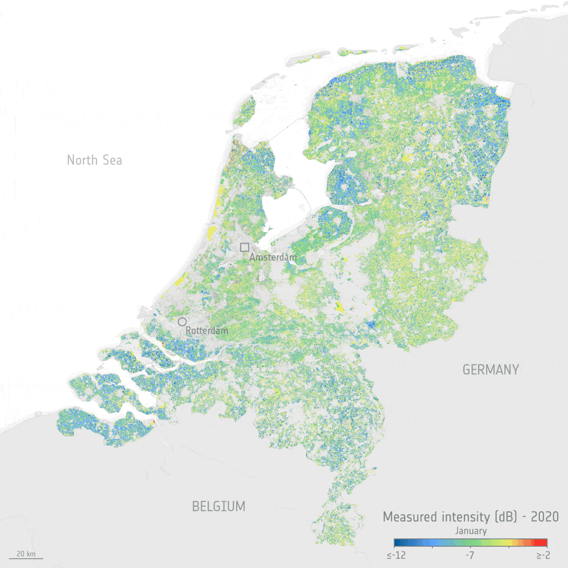
The Copernicus Sentinel satellite missions measure and image our planet in different ways to return a wealth of complementary information so that we can understand and track how our world is changing, and how to better manage our environment and resources. Thanks to the benefits of different types of data from two particular Copernicus Sentinel missions and an ingenious new dataset tool, people working in the agriculture sector, but who are not satellite data experts, can monitor the health and development of crops, right down to each crop in individual fields.
Digital tools have enabled a quick response to clients comments and requirements
8.2.2022 17:16 Bentley SystemsPressCoverage
Smart Water Magazine, Southern Europe
Read the article