


![]()

zprávy
zdroje zpráv:Přerušení dodávky elektřiny na KÚ pro MS kraj
21.7.2021 13:39 ČÚZK /Urady/Katastralni-urady/Katastralni-urady/Katastralni-urad-pro-Moravskoslezsky-kraj/Katastralni-pracoviste/KP-Krnov/O-uradu/Aktuality/Preruseni-dodavky-elektriny-na-KU-pro-MS-krajPřerušení dodávky elektřiny na KÚ pro MS kraj
21.7.2021 13:34 ČÚZK - předpisy a opatření Český úřad zeměměřický a katastrální zveřejnil novou aktualitu:Dne 23. 7. 2021 přeruší společnost ČEZ Distribuce, a.s. Katastrálnímu úřadu pro Moravskoslezský kraj se sídlem v Opavě dodávku elektřiny v době od 7:30 do 15:00 hod.
Z tohoto důvodu nebude v uvedeném termínu pro jednotlivá katastrální pracoviště uvedeného katastrálního úřadu dostupná aktualizace e-mailové schránky, nebude tedy možno odesílat ani přijímat zprávy prostřednictvím e-mailové pošty.
Přerušení dodávky elektřiny na KÚ pro MS kraj
21.7.2021 13:34 ČÚZK /Urady/Katastralni-urady/Katastralni-urady/Katastralni-urad-pro-Moravskoslezsky-kraj/Katastralni-pracoviste/KP-Karvina/O-uradu/Aktuality/Preruseni-dodavky-elektriny-na-KU-pro-MS-krajPřerušení dodávky elektřiny na KÚ pro MS kraj
21.7.2021 13:32 ČÚZK /Urady/Katastralni-urady/Katastralni-urady/Katastralni-urad-pro-Moravskoslezsky-kraj/Katastralni-pracoviste/KP-Frydek-Mistek/O-uradu/Aktuality/Preruseni-dodavky-elektriny-na-KU-pro-MS-krajPřerušení dodávky elektřiny na KÚ pro MS kraj
21.7.2021 13:32 ČÚZK - předpisy a opatření Český úřad zeměměřický a katastrální zveřejnil novou aktualitu:Dne 23. 7. 2021 přeruší společnost ČEZ Distribuce, a.s. Katastrálnímu úřadu pro Moravskoslezský kraj se sídlem v Opavě dodávku elektřiny v době od 7:30 do 15:00 hod.
Z tohoto důvodu nebude v uvedeném termínu pro jednotlivá katastrální pracoviště uvedeného katastrálního úřadu dostupná aktualizace e-mailové schránky, nebude tedy možno odesílat ani přijímat zprávy prostřednictvím e-mailové pošty.
Přerušení dodávky elektřiny na KÚ pro MS kraj
21.7.2021 13:27 ČÚZK - předpisy a opatření Český úřad zeměměřický a katastrální zveřejnil novou aktualitu:Dne 23. 7. 2021 přeruší společnost ČEZ Distribuce, a.s. Katastrálnímu úřadu pro Moravskoslezský kraj se sídlem v Opavě dodávku elektřiny v době od 7:30 do 15:00 hod.
Z tohoto důvodu nebude v uvedeném termínu pro jednotlivá katastrální pracoviště uvedeného katastrálního úřadu dostupná aktualizace e-mailové schránky, nebude tedy možno odesílat ani přijímat zprávy prostřednictvím e-mailové pošty.
Přerušení dodávky elektřiny na KÚ pro MS kraj
21.7.2021 13:27 ČÚZK /Urady/Katastralni-urady/Katastralni-urady/Katastralni-urad-pro-Moravskoslezsky-kraj/Katastralni-pracoviste/KP-Bruntal/O-uradu/Aktuality/Preruseni-dodavky-elektriny-na-KU-pro-MS-krajGEOSTAR se stává součástí HRDLIČKA Holding
21.7.2021 9:39 Hrdlička Brněnská geologická a geotechnická firma je nově členem skupiny HRDLIČKA Holding.Vše na jednom místě. Mapové aplikace umí ukázat cenu půdy, riziko povodní i viniční tratě či ložiska nerostných surovin (TZ)
21.7.2021 8:57 GISportal.cz
Projít se virtuálně z pohodlí vlastního obýváku po blízkém či vzdálenějším městě není díky mapovým aplikacím již dávno žádný problém. Ty moderní toho ale vedle prostého zobrazení ortofotomapy či panoramatického pohledu nabízejí daleko více. Podívat se lze například na to, kde se v okolí nachází honitby, viniční tratě či ložiska nerostných surovin. Stejně tak umí […]
The post Vše na jednom místě. Mapové aplikace umí ukázat cenu půdy, riziko povodní i viniční tratě či ložiska nerostných surovin (TZ) appeared first on GISportal.cz.
Vše na jednom místě. Mapové aplikace umí ukázat cenu půdy, riziko povodní i viniční tratě či ložiska nerostných surovin (TZ)
21.7.2021 8:57 GISportal.czKurátor/ka sbírkových mobiliárních fondů
21.7.2021 6:55 Zeměměřický úřad Zeměměřický úřadvypisuje výběrové řízení na místo
Kurátor/ka sbírkových mobiliárních fondů
Kurátor/ka sbírkových mobiliárních fondů
21.7.2021 6:55 ČÚZK - předpisy a opatření Zeměměřický úřadvypisuje výběrové řízení na místo
Kurátor/ka sbírkových mobiliárních fondů
Kurátor/ka sbírkových mobiliárních fondů
21.7.2021 6:55 ČÚZK - volná místa Zeměměřický úřad vypisuje výběrové řízení na místo Kurátor/ka sbírkových mobiliárních fondůKurátor/ka sbírkových mobiliárních fondů
21.7.2021 6:55 ČÚZK /Urady/Zememericky-urad/Volna-mista/Kurator-ka-sbirkovych-mobiliarnich-fondu-(1)Aktualizace prohlížecích služeb ZABAGED®
21.7.2021 0:00
ČÚZK - Geoportál
Aktualizace prohlížecích služeb ZABAGED®Prohlížecí služby ZABAGED®, ZABAGED® (vizualizace nad ortofoto) a ZABAGED® (vizualizace ZM10) již poskytují veškeré změny po červencové aktualizaci datové sady ZABAGED®.
Aktualizace prohlížecích služeb ZABAGED®
21.7.2021 0:00
ČÚZK - Geoportál
Aktualizace prohlížecích služeb ZABAGED®Prohlížecí služby ZABAGED®, ZABAGED® (vizualizace nad ortofoto) a ZABAGED® (vizualizace ZM10) již poskytují veškeré změny po červencové aktualizaci datové sady ZABAGED®.
Aktualizace prohlížecích služeb ZABAGED®
21.7.2021 0:00
ČÚZK - Geoportál
Aktualizace prohlížecích služeb ZABAGED®Prohlížecí služby ZABAGED®, ZABAGED® (vizualizace nad ortofoto) a ZABAGED® (vizualizace ZM10) již poskytují veškeré změny po červencové aktualizaci datové sady ZABAGED®.
Aktualizace prohlížecích služeb ZABAGED®
21.7.2021 0:00
ČÚZK - Geoportál
Aktualizace prohlížecích služeb ZABAGED®Prohlížecí služby ZABAGED®, ZABAGED® (vizualizace nad ortofoto) a ZABAGED® (vizualizace ZM10) již poskytují veškeré změny po červencové aktualizaci datové sady ZABAGED®.
Aktualizace prohlížecích služeb ZABAGED®
21.7.2021 0:00 ČÚZK - Geoportál Aktualizace prohlížecích služeb ZABAGED®Prohlížecí služby ZABAGED®, ZABAGED® (vizualizace nad ortofoto) a ZABAGED® (vizualizace ZM10) již poskytují veškeré změny po červencové aktualizaci datové sady ZABAGED®.
Aktualizace prohlížecích služeb ZABAGED®
21.7.2021 0:00
ČÚZK - Geoportál
Aktualizace prohlížecích služeb ZABAGED®Prohlížecí služby ZABAGED®, ZABAGED® (vizualizace nad ortofoto) a ZABAGED® (vizualizace ZM10) již poskytují veškeré změny po červencové aktualizaci datové sady ZABAGED®.
Vyhodnotenie online dotazníka - využívanie online prostriedkov
21.7.2021 0:00 Komora geodetů a kartografů SRAktualizace prohlížecích služeb ZABAGED®
21.7.2021 0:00
ČÚZK - Geoportál
Aktualizace prohlížecích služeb ZABAGED®Prohlížecí služby ZABAGED®, ZABAGED® (vizualizace nad ortofoto) a ZABAGED® (vizualizace ZM10) již poskytují veškeré změny po červencové aktualizaci datové sady ZABAGED®.
Aktualizace prohlížecích služeb ZABAGED®
21.7.2021 0:00
ČÚZK - Geoportál
Aktualizace prohlížecích služeb ZABAGED®Prohlížecí služby ZABAGED®, ZABAGED® (vizualizace nad ortofoto) a ZABAGED® (vizualizace ZM10) již poskytují veškeré změny po červencové aktualizaci datové sady ZABAGED®.
Aktualizace prohlížecích služeb ZABAGED®
21.7.2021 0:00
ČÚZK - Geoportál
Aktualizace prohlížecích služeb ZABAGED®Prohlížecí služby ZABAGED®, ZABAGED® (vizualizace nad ortofoto) a ZABAGED® (vizualizace ZM10) již poskytují veškeré změny po červencové aktualizaci datové sady ZABAGED®.
Aktualizace prohlížecích služeb ZABAGED®
21.7.2021 0:00 ČÚZK - Geoportál Aktualizace prohlížecích služeb ZABAGED®Prohlížecí služby ZABAGED®, ZABAGED® (vizualizace nad ortofoto) a ZABAGED® (vizualizace ZM10) již poskytují veškeré změny po červencové aktualizaci datové sady ZABAGED®.
Aktualizace prohlížecích služeb ZABAGED®
21.7.2021 0:00
ČÚZK - Geoportál
Aktualizace prohlížecích služeb ZABAGED®Prohlížecí služby ZABAGED®, ZABAGED® (vizualizace nad ortofoto) a ZABAGED® (vizualizace ZM10) již poskytují veškeré změny po červencové aktualizaci datové sady ZABAGED®.
Aktualizace prohlížecích služeb ZABAGED®
21.7.2021 0:00 ČÚZK - Geoportál Aktualizace prohlížecích služeb ZABAGED®Prohlížecí služby ZABAGED®, ZABAGED® (vizualizace nad ortofoto) a ZABAGED® (vizualizace ZM10) již poskytují veškeré změny po červencové aktualizaci datové sady ZABAGED®.
Aktualizace prohlížecích služeb ZABAGED®
21.7.2021 0:00 ČÚZK - Geoportál Aktualizace prohlížecích služeb ZABAGED®Prohlížecí služby ZABAGED®, ZABAGED® (vizualizace nad ortofoto) a ZABAGED® (vizualizace ZM10) již poskytují veškeré změny po červencové aktualizaci datové sady ZABAGED®.
Aktualizace prohlížecích služeb ZABAGED®
21.7.2021 0:00
ČÚZK - Geoportál
Aktualizace prohlížecích služeb ZABAGED®Prohlížecí služby ZABAGED®, ZABAGED® (vizualizace nad ortofoto) a ZABAGED® (vizualizace ZM10) již poskytují veškeré změny po červencové aktualizaci datové sady ZABAGED®.
Aktualizace prohlížecích služeb ZABAGED®
21.7.2021 0:00
ČÚZK - Geoportál
Aktualizace prohlížecích služeb ZABAGED®Prohlížecí služby ZABAGED®, ZABAGED® (vizualizace nad ortofoto) a ZABAGED® (vizualizace ZM10) již poskytují veškeré změny po červencové aktualizaci datové sady ZABAGED®.
Aktualizace prohlížecích služeb ZABAGED®
21.7.2021 0:00 ČÚZK - Geoportál Aktualizace prohlížecích služeb ZABAGED®Prohlížecí služby ZABAGED®, ZABAGED® (vizualizace nad ortofoto) a ZABAGED® (vizualizace ZM10) již poskytují veškeré změny po červencové aktualizaci datové sady ZABAGED®.
Aktualizace prohlížecích služeb ZABAGED®
21.7.2021 0:00 ČÚZK - Geoportál Aktualizace prohlížecích služeb ZABAGED®Prohlížecí služby ZABAGED®, ZABAGED® (vizualizace nad ortofoto) a ZABAGED® (vizualizace ZM10) již poskytují veškeré změny po červencové aktualizaci datové sady ZABAGED®.
Aktualizace prohlížecích služeb ZABAGED®
21.7.2021 0:00 ČÚZK - Geoportál Aktualizace prohlížecích služeb ZABAGED®Prohlížecí služby ZABAGED®, ZABAGED® (vizualizace nad ortofoto) a ZABAGED® (vizualizace ZM10) již poskytují veškeré změny po červencové aktualizaci datové sady ZABAGED®.
DATAMARK sponsoring and exhibiting at 2021 nena conference
20.7.2021 21:35 GISCafe.com Webcasts-Webinars WHO: DATAMARK, the public safety GIS team of Michael Baker International. As trusted advisors in public …New Esri Book Introduces Young Readers to Spatial Thinking
20.7.2021 17:19 GISCafe.com Webcasts-Webinars Geographic Concepts Are Conveyed through South American Adventure StoryREDLANDS, Calif. — (BUSINESS WIRE) — July 20, 2021 —
Esri, …
MSA Safety Announces Investment and Collaboration Agreement with Swiss Autonomous Drone Technology Firm to Enhance Fire Service Offerings
20.7.2021 17:19 GISCafe.com Webcasts-Webinars PITTSBURGH, July 20, 2021 — (PRNewswire) — MSA Safety Incorporated (NYSE: MSA), the global leader in the development, manufacture …EarthDaily Analytics Announces Timeline for the Launch of Next Generation Satellite Constellation
20.7.2021 17:19 GISCafe.com Webcasts-Webinars EarthDaily Analytics unveils plan to launch a new ground-breaking constellation in 2023VANCOUVER, BC, July 20, 2021 — (PRNewswire) — …
Bees360 Integrates with magicplan to Bring Real-time AR Technology to Property Claims
20.7.2021 17:19 GISCafe.com Webcasts-Webinars HOUSTON and MONTREAL, July 20, 2021 — (PRNewswire) — Bees360, a leading AI technology innovator for property claims and underwriting …Video: Expanding Racial Equity through Community Action
20.7.2021 17:19 GISCafe.com Webcasts-WebinarsRobotic Skies Establishes New Headquarters in Utah to Expand Service Offerings for Commercial Drone Maintenance Network
20.7.2021 16:41 GISCafe.com Webcasts-Webinars Robotic Skies, Inc, a global marketplace for professional commercial drone maintenance and repair services, announced its new headquarters in Salt …Quanergy’s 3D LiDAR Solution Selected for First V2X Smart City Deployment in Korea
20.7.2021 16:41 GISCafe.com Webcasts-Webinars LiDAR-based IoT solution deployed in Busan, one of several pilot smart cities in South KoreaQuanergy 3D LiDAR solution delivers greater than 95% …
RapidSOS Launches RapidSOS Partner Network to Unify Public Safety Tools and Resources Available to 911
20.7.2021 16:41 GISCafe.com Webcasts-Webinars Featuring 20 inaugural members, RapidSOS Partner Network brings cutting edge technology such as drones, multimedia, texting, and geospatial layers to …20210720_Rada / odborný rada oddělení právních vztahů k nemovitostem
20.7.2021 13:43 ČÚZK /Urady/Katastralni-urady/Katastralni-urady/Katastralni-urad-pro-Stredocesky-kraj/Katastralni-pracoviste/KP-Rakovnik/O-uradu/Aktuality/20210113_odborny-rada,-reditel-Katastralniho-p-(1)20210720_Rada / odborný rada oddělení právních vztahů k nemovitostem
20.7.2021 13:43 ČÚZK - předpisy a opatření Katastrální úřad pro Středočeský kraj - Katastrální pracoviště Rakovník Vyhlášení výběrového řízení: Rada / odborný rada oddělení právních vztahů k nemovitostem V části "Úřední deska", v sekci "Oznámení a jiná úřední sdělení" bylo vystaveno "Oznámení o vyhlášení výběrového řízení na obsazení služebního místa Rada / odborný rada oddělení právních vztahů k nemovitostem"EK přijala nové nařízení s odkladem použitelnosti standardních scénářů EU na konec 2023
20.7.2021 11:41 UAVAJako první informujeme, že datum použitelnosti standardních scénářů EU pro drony se odkládá na 2. prosince 2023. Evropská komise přijala nařízení (EU) 2021/1166 a nyní: – Provozovatelé UAS budou moci deklarovat provoz na základě evropských standardních scénářů až po 2. prosinci 2023; – zelená blikající světla a dálková identifikace pro bezpilotní letouny provozované ve specifické […]
The post EK přijala nové nařízení s odkladem použitelnosti standardních scénářů EU na konec 2023 appeared first on UAV Aliance pro bezpilotní letecký průmysl.
Rozhraní služby UtilityReport se spol. ČEPS
20.7.2021 10:31 Hrdlička Integrace mezi naší službou a novým systémem AVES.Aliance je opět partnerem Drone Industry Barometer 2021
20.7.2021 10:20 UAVAAliance je opět partnerem Drone Industry Barometer 2021, největšího mezinárodního průzkumu Drone Industry Insights a tímto prosíme o co největší účast z České republiky, kdyby se nám opět povedlo být mezi Top 10 státy s největší účastí jako v loňském roce 2020. Průzkum probíhá do poloviny srpna a pro všechny respondenty budou výsledky tohoto rozsáhlého […]
The post Aliance je opět partnerem Drone Industry Barometer 2021 appeared first on UAV Aliance pro bezpilotní letecký průmysl.
Podpořené projekty MAS Zubří země
20.7.2021 9:55 T-MAPYThe post Podpořené projekty MAS Zubří země appeared first on T-MAPY spol. s r.o..
Za poklady Česka s ČT edu (TZ)
20.7.2021 8:44 GISportal.cz
Letní prázdniny jsou tu. Vydejte se na výpravu za poklady Česka. Poznejte ty nejkrásnější přírodní a kulturní lokality, ale i místa zapomenutá a méně známá. Najděte ukryté kešky, pořiďte fotky zajímavých míst ze svých cest, pošlete je na facebook ČT edu a hrajte o hodnotné ceny. Naplánujte si společně s rodiči letošní dovolenou na portálu […]
The post Za poklady Česka s ČT edu (TZ) appeared first on GISportal.cz.
Za poklady Česka s ČT edu (TZ)
20.7.2021 8:44 GISportal.czVectorworks, Inc. Joins the Open Geospatial Consortium to Contribute to GIS and BIM Standards
19.7.2021 20:28 GISCafe.com Webcasts-Webinars Global Design and BIM Software Provider Will Serve as Technical Member of International ConsortiumCOLUMBIA, Md., July 19, 2021 — (PRNewswire) …
Swift Navigation and KDDI Announce Partnership to Build on the Global Expansion of Precise Positioning
19.7.2021 16:56 GISCafe.com Webcasts-Webinars SAN FRANCISCO, July 19, 2021 (GLOBE NEWSWIRE) -- Swift Navigation, a San Francisco-based tech firm redefining GNSS (Global Navigation Satellite …PrecisionHawk Teams with NRECA to Upskill UAV Pilots Conducting Electric Grid Inspections
19.7.2021 16:56 GISCafe.com Webcasts-Webinars Hands-on UAV course will help address reliability and safety for electric co-ops across AmericaRALEIGH, N.C. — (BUSINESS WIRE) — July …
Luminar Acquiring Exclusive Lidar Chip Partner and Specialized Fab
19.7.2021 16:56 GISCafe.com Webcasts-Webinars Luminar’s New Fifth-Generation Lidar Chip with Optogration Technology Enables Iris Sensor; Acquisition Secures Supply with One Million Unit Per …Seoul Robotics Introduces New Deployment Ready LiDAR Perception System
19.7.2021 16:56 GISCafe.com Webcasts-Webinars ANN ARBOR, Mich., July 19, 2021 (GLOBE NEWSWIRE) -- Seoul Robotics, a 3D computer vision company using AI and machine learning for intelligent …Decisive Point and Newlab Announce 2021 NSIN Propel Cohort of Companies Selected to Apply Transformative Technology to Government, Defense, and Space
19.7.2021 16:56 GISCafe.com Webcasts-Webinars NSIN Propel will enable the 12 selected companies to leverage their technology solutions to address key national security needsBROOKLYN, N.Y., July …
Galileo Second Generation proof-of-concept testing begins
19.7.2021 16:56 ESA Navigation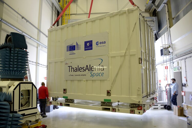
The first Galileo Second Generation hardware has begun testing, with test versions of the satellites’ navigation payloads undergoing evaluation by Airbus Defence and Space at their Ottobrunn facility in Germany and by Thales Alenia Space at ESA’s ESTEC technical centre in the Netherlands.
Anand Gopalan Stepping Down as CEO of Velodyne Lidar
19.7.2021 16:55 GISCafe.com Webcasts-Webinars Provides Progress Update on Growth StrategySAN JOSE, Calif. — (BUSINESS WIRE) — July 19, 2021 — Velodyne Lidar, Inc. (NASDAQ: …
rada/odborný rada – vedoucí právního oddělení VII.
19.7.2021 16:53 ČÚZK /Urady/Katastralni-urady/Katastralni-urady/Katastralni-urad-pro-hlavni-mesto-Prahu/Uredni-deska/Oznameni-a-jina-uredni-sdeleni/Volna-mista/DMS/rada-odborny-rada-–-vedouci-pravniho-oddeleni-VIIrada/odborný rada – vedoucí právního oddělení VII.
19.7.2021 16:53 ČÚZK - předpisy a opatření Katastrální úřad pro hlavní město Prahuvypisuje výběrové řízení na místo
rada/odborný rada – vedoucí právního oddělení VII.
rada/odborný rada – vedoucí právního oddělení VII.
19.7.2021 16:53 ČÚZK - volná místa Katastrální úřad pro hlavní město Prahu vypisuje výběrové řízení na místo rada/odborný rada – vedoucí právního oddělení VII.2021-2030: Our Last Best Chance to Protect the Ocean for the Benefit of Humanity
19.7.2021 16:52 GISCafe.com Webcasts-Webinarspracovník podatelny
19.7.2021 15:59 ČÚZK - volná místa Katastrální úřad pro hlavní město Prahu Katastrální pracoviště Praha vypisuje výběrové řízení na místo pracovník podatelnyBuilding a sustainable future with the power of #EUSpace
19.7.2021 15:03 European GNSS Agency
Copernicus, Galileo, and EGNOS, when working in conjunction or -as standalone systems- are key assets to implementing green energy solutions and to making the construction sector more efficient.
Decoupling economic growth from resource extraction and environmental degradation is in the heart of the EU Green Deal to. Turning into clean forms of energy such as solar, wind and tidal power will enable the Union to curb emissions, transform Europe’s energy mix and thus reverse climate change.
Green infrastructures, such as solar panels or wind turbines are costly installations. They require monitoring to ensure their proper functioning and performance optimization. Often, natural hazards such land subsidence, or landslides can negatively affect the operations of these infrastructures. That’s where EU Space kicks in!
#EUSpace supporting the use of green power
Satellite-based remote sensing from Copernicus is a cost-effective solution which keeps an eye on clean energy infrastructures, offering precious information on their integrity and targeted maintenance. Geospatial data by the EU’s Earth Observation system can also be used to enable a better planning of these assets by offering greater situational awareness and help mitigate risks such as vegetation encroachment on power grids and turbines. Moreover, Copernicus, can optimize the performance of tidal power generators, by offering data on the rise and fall of tide through tidal currents prediction systems. Likewise, the Copernicus Atmosphere Monitoring Service uses information from satellites and its models to provide policymakers and solar industry companies, with quality metrics on sunshine or cloud coverage over specific areas. This helps the sector to better plan the installation of panels and thus to maximise their outputs.
The concept of smart power grids is gaining more and more momentum and electric utility companies are investing into them to reduce costs and optimise user experience and more efficiently manage their electric power networks.
Smart grid systems require precise timing and synchronization down to a nanosecond level and GNSS clocks are used a prime source or as a backup time reference source in case of outages. Ultra-precise clocks on board Galileo satellites can provide accurate time and frequency synchronization to smart grids making them more robust.
#EUSpace for a cleaner and more efficient construction sector
Population growth and urbanisation are pushing the boundaries for resource exploitation and are creating a huge demand for civil infrastructure such as buildings, subways and train lines, bridges, dams, highways and airports. According to the EUSPA market report, by 2025 83% of geomatics equipment used for cadastral surveying and construction applications is GNSS-enabled. As of today, more than 80% of newly manufactured geomatics equipment and instruments use Galileo.
Both the construction sector and urban planning are directly benefitting from the EU Space Programme namely from the additional accuracy of Galileo and EGNOS which allows surveyors to accurately pinpoint structures and reference points. Copernicus offers high resolution images to assess the state of civil infrastructure including dams, or pipelines and track water loss. What is more, Galileo and EGNOS-enabled drones can accurately and safely fly across points of interest and assess for example heat loss in buildings and facilities.
Media note: This feature can be republished without charge provided the European Union Agency for the Space Programme (EUSPA) is acknowledged as the source at the top or the bottom of the story. You must request permission before you use any of the photographs on the site. If you republish, we would be grateful if you could link back to the EUSPA website (http://www.euspa.europa.eu).
Building a sustainable future with the power of #EUSpace
19.7.2021 15:03 European GNSS AgencyCopernicus, Galileo, and EGNOS, when working in conjunction or -as standalone systems- are key assets to implementing green energy solutions and to making the construction sector more efficient.
Decoupling economic growth from resource extraction and environmental degradation is at the heart of the EU Green Deal. Turning into clean forms of energy such as solar, wind and tidal power will enable the Union to curb emissions, transform Europe’s energy mix and thus reverse climate change.
Green infrastructures, such as solar panels or wind turbines are costly installations. They require monitoring to ensure their proper functioning and performance optimization. Often, natural hazards such land subsidence, or landslides can negatively affect the operations of these infrastructures. That’s where EU Space kicks in!
#EUSpace supporting the use of green power
Satellite-based remote sensing from Copernicus is a cost-effective solution which keeps an eye on clean energy infrastructures, offering precious information on their integrity and targeted maintenance. Geospatial data by the EU’s Earth Observation system can also be used to enable better planning of these assets by offering greater situational awareness and help mitigate risks such as vegetation encroachment on power grids and turbines. Moreover, Copernicus can optimize the performance of tidal power generators, by offering data on the rise and fall of the tide through tidal currents prediction systems. Likewise, the Copernicus Atmosphere Monitoring Service uses information from satellites and its models to provide policymakers and solar industry companies, with quality metrics on sunshine or cloud coverage over specific areas. This helps the sector to better plan the installation of panels and thus to maximise their outputs.
The concept of smart power grids is gaining more and more momentum and electric utility companies are investing into them to reduce costs and optimise user experience and more efficiently manage their electric power networks.
Smart grid systems require precise timing and synchronization down to a nanosecond level and GNSS clocks are used as a prime source or as a backup time reference source in case of outages. Ultra-precise clocks onboard Galileo satellites can provide accurate time and frequency synchronization to smart grids making them more robust.
#EUSpace for a cleaner and more efficient construction sector
Population growth and urbanisation are pushing the boundaries for resource exploitation and are creating a huge demand for civil infrastructures such as buildings, subways, and train lines, bridges, dams, highways, and airports. According to the EUSPA market report, by 2025 83% of geomatics equipment used for cadastral surveying and construction applications will be GNSS-enabled. As of today, more than 80% of newly manufactured geomatics equipment and instruments use Galileo.
Both the construction sector and urban planning are directly benefitting from the EU Space Programme namely from the additional accuracy of Galileo and EGNOS which allows surveyors to accurately pinpoint structures and reference points. Copernicus offers high-resolution images to assess the state of civil infrastructure including dams, or pipelines and track water loss. What is more, Galileo and EGNOS-enabled drones can accurately and safely fly across points of interest and assess for example heat loss in buildings and facilities.
Media note: This feature can be republished without charge provided the European Union Agency for the Space Programme (EUSPA) is acknowledged as the source at the top or the bottom of the story. You must request permission before you use any of the photographs on the site. If you republish, we would be grateful if you could link back to the EUSPA website (http://www.euspa.europa.eu).
Building a sustainable future with the power of #EUSpace
19.7.2021 15:03 European GNSS AgencyCopernicus, Galileo, and EGNOS, when working in conjunction or -as standalone systems- are key assets to implementing green energy solutions and to making the construction sector more efficient.
Decoupling economic growth from resource extraction and environmental degradation is at the heart of the EU Green Deal. Turning into clean forms of energy such as solar, wind and tidal power will enable the Union to curb emissions, transform Europe’s energy mix and thus reverse climate change.
Green infrastructures, such as solar panels or wind turbines are costly installations. They require monitoring to ensure their proper functioning and performance optimization. Often, natural hazards such as land subsidence, or landslides can negatively affect the operations of these infrastructures. That’s where EU Space kicks in!
#EUSpace supporting the use of green power
Satellite-based remote sensing from Copernicus is a cost-effective solution which keeps an eye on clean energy infrastructures, offering precious information on their integrity and targeted maintenance. Geospatial data by the EU’s Earth Observation system can also be used to enable better planning of these assets by offering greater situational awareness and help mitigate risks such as vegetation encroachment on power grids and turbines. Moreover, Copernicus can optimize the performance of tidal power generators, by offering data on the rise and fall of the tide through tidal currents prediction systems. Likewise, the Copernicus Atmosphere Monitoring Service uses information from satellites and its models to provide policymakers and solar industry companies, with quality metrics on sunshine or cloud coverage over specific areas. This helps the sector to better plan the installation of panels and thus to maximise their outputs.
The concept of smart power grids is gaining more and more momentum and electric utility companies are investing into them to reduce costs and optimise user experience and more efficiently manage their electric power networks.
Smart grid systems require precise timing and synchronization down to a nanosecond level and GNSS clocks are used as a prime source or as a backup time reference source in case of outages. Ultra-precise clocks onboard Galileo satellites can provide accurate time and frequency synchronization to smart grids making them more robust.
#EUSpace for a cleaner and more efficient construction sector
Population growth and urbanisation are pushing the boundaries for resource exploitation and are creating a huge demand for civil infrastructures such as buildings, subways, and train lines, bridges, dams, highways, and airports. According to the EUSPA market report, by 2025 83% of geomatics equipment used for cadastral surveying and construction applications will be GNSS-enabled. As of today, more than 80% of newly manufactured geomatics equipment and instruments use Galileo.
Both the construction sector and urban planning are directly benefitting from the EU Space Programme namely from the additional accuracy of Galileo and EGNOS which allows surveyors to accurately pinpoint structures and reference points. Copernicus offers high-resolution images to assess the state of civil infrastructure including dams, or pipelines and track water loss. What is more, Galileo and EGNOS-enabled drones can accurately and safely fly across points of interest and assess for example heat loss in buildings and facilities.
Media note: This feature can be republished without charge provided the European Union Agency for the Space Programme (EUSPA) is acknowledged as the source at the top or the bottom of the story. You must request permission before you use any of the photographs on the site. If you republish, we would be grateful if you could link back to the EUSPA website (http://www.euspa.europa.eu).
rada/odborný rada v oddělení právních vztahů k nemovitostem na Katastrálním pracovišti Hustopeče
19.7.2021 14:48 ČÚZK - volná místa Katastrální úřad pro Jihomoravský kraj Katastrální pracoviště Hustopeče vypisuje výběrové řízení na místo rada/odborný rada v oddělení právních vztahů k nemovitostem na Katastrálním pracovišti Hustopečerada/odborný rada v oddělení právních vztahů k nemovitostem na Katastrálním pracovišti Hustopeče
19.7.2021 14:48 ČÚZK /Urady/Katastralni-urady/Katastralni-urady/Katastralni-urad-pro-Jihomoravsky-kraj/Volna-mista/DMS/rada-odborny-rada-v-oddeleni-pravnich-vztahu-k-nemrada/odborný rada v oddělení právních vztahů k nemovitostem na Katastrálním pracovišti Hustopeče
19.7.2021 14:48 ČÚZK - předpisy a opatření Katastrální úřad pro Jihomoravský kraj Katastrální pracoviště Hustopečevypisuje výběrové řízení na místo
rada/odborný rada v oddělení právních vztahů k nemovitostem na Katastrálním pracovišti Hustopeče
rada/odborný rada v oddělení dokumentace KN na Katastrálním pracovišti Boskovice
19.7.2021 14:36 ČÚZK - předpisy a opatření Katastrální úřad pro Jihomoravský kraj Katastrální pracoviště Boskovicevypisuje výběrové řízení na místo
rada/odborný rada v oddělení dokumentace KN na Katastrálním pracovišti Boskovice
rada/odborný rada v oddělení dokumentace KN na Katastrálním pracovišti Boskovice
19.7.2021 14:36 ČÚZK - volná místa Katastrální úřad pro Jihomoravský kraj Katastrální pracoviště Boskovice vypisuje výběrové řízení na místo rada/odborný rada v oddělení dokumentace KN na Katastrálním pracovišti Boskovicerada/odborný rada v oddělení dokumentace KN na Katastrálním pracovišti Boskovice
19.7.2021 14:36 ČÚZK /Urady/Katastralni-urady/Katastralni-urady/Katastralni-urad-pro-Jihomoravsky-kraj/Uredni-deska/Oznameni-a-jina-uredni-sdeleni/Volna-mista/DMS/rada-odborny-rada-v-oddeleni-dokumentace-KN-na-KatRozhraní služby UtilityReport se spol. ČEPS
19.7.2021 14:34 Hrdlička V roce 2009 naše společnost spustila službu UtilityReport.Rozhraní UtilityReport se společností ČEPS
19.7.2021 14:22 Hrdlička V roce 2009 naše společnost spustila službu UtilityReport.Přerušení dodávky el. energie - KP Jindřichův Hradec
19.7.2021 10:19 ČÚZK - předpisy a opatření Katastrální úřad pro Jihočeský kraj - Katastrální pracoviště Jindřichův Hradec zveřejnil novou aktualitu: Dne 26.07.2021 v době od 10:45 – 15:15 hod. bude z důvodu přerušení dodávky elektrické energie na Katastrálním pracovišti Jindřichův Hradec omezen provoz.V této době nebude možno poskytovat na počkání informace z katastru nemovitostí a bude omezen také příjem podání:
- žádosti o informace z katastru budou přijímány pouze ve formě objednávek
- podání budou přijímána bez možnosti přidělení čísla jednacího
- správní poplatek půjde uhradit pouze ve formě kolkových známek nebo v hotovosti, příp. výzvou k úhradě převodem na účet. Nelze platit platební kartou.
Přerušení dodávky el. energie - KP Jindřichův Hradec
19.7.2021 10:19 ČÚZK /Urady/Katastralni-urady/Katastralni-urady/Katastralni-urad-pro-Jihocesky-kraj/Katastralni-pracoviste/KP-Jindrichuv-Hradec/O-uradu/Aktuality/Preruseni-dodavky-el-energie-KP-Jindrichuv-Hradrada/odborný rada – inspektor Zeměměřického a katastrálního inspektorátu v Pardubicích
19.7.2021 9:44 ČÚZK /Urady/Zememericke-a-katastralni-inspektoraty/Zememericke-a-katastralni-inspektoraty/Zememericky-a-katastralni-inspektorat-v-Pardubicic/Volna-mista/inspektor-Zememerickeho-a-katastralniho-inspektorarada/odborný rada – inspektor Zeměměřického a katastrálního inspektorátu v Pardubicích
19.7.2021 9:44 ČÚZK - předpisy a opatření Zeměměřický a katastrální inspektorát v Pardubicíchvypisuje výběrové řízení na místo
rada/odborný rada – inspektor Zeměměřického a katastrálního inspektorátu v Pardubicích
rada/odborný rada – inspektor Zeměměřického a katastrálního inspektorátu v Pardubicích
19.7.2021 9:44 ČÚZK - volná místa Zeměměřický a katastrální inspektorát v Pardubicích vypisuje výběrové řízení na místo rada/odborný rada – inspektor Zeměměřického a katastrálního inspektorátu v PardubicíchNový odborný kurz “Bezpilotní letecké prostředky (UAV) pro ochranu životního prostředí”
19.7.2021 9:28 GISportal.cz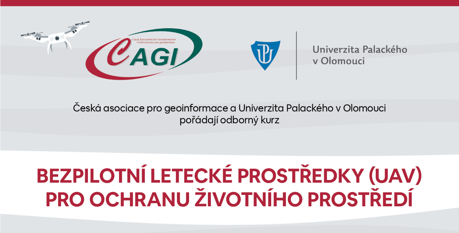
Česká asociace pro geoinformace a Univerzita Palackého v Olomouci pořádají odborný kurz s názvem “Bezpilotní letecké prostředky (UAV) pro ochranu životního prostředí“, který se bude konat 21. a 22. září 2021 v Olomouci. Kurz je určen pro úředníky územně samosprávných celků a vedoucí úředníky územně samosprávných celků pracujících v oblasti ochrany životního prostředí. Předpokládá se […]
The post Nový odborný kurz “Bezpilotní letecké prostředky (UAV) pro ochranu životního prostředí” appeared first on GISportal.cz.
Nový odborný kurz „Bezpilotní letecké prostředky (UAV) pro ochranu životního prostředí“
19.7.2021 9:28 GISportal.czPozvánka na výstavu Jak se měří svět [Knihovna geografie, byTopic]
19.7.2021 0:00 Katedra aplikované geoinformatiky a kartografie Přf UK Knihovna geografie Vás zve na výstavu Jak se měří svět, která se koná v Národním technickém muzeu od 30. června 2021 do 27. února 2022.Mapping the Pacific - pozvánka na online konferenci [Knihovna geografie, byTopic]
19.7.2021 0:00 Katedra aplikované geoinformatiky a kartografie Přf UK Ve dnech 25. - 26. srpna 2021 se v australském Sydney uskuteční konference, věnovaná dějinám mapování Tichého oceánu. Bude se zabývat jak kartografickým povědomím původních obyvatel Tichomoří, tak i průzkumy a mapováním, které prováděli Evropané při svých plavbách v Pacifiku od raného novověku do 19. století.Novinky z Ústřední knihovny UK - od září s novou knihovní platformou Alma! [Knihovna geografie, byTopic]
19.7.2021 0:00 Katedra aplikované geoinformatiky a kartografie Přf UK DŮLEŽITÉ! Abychom pro Vás novou platformu mohli spustit od září 2021, je potřeba dočasně uzavřít provoz všech knihoven UK. Celouniverzitní uzavírka bude probíhat od 12. do 31. srpna 2021 včetně. Během této doby budou do nové platformy přenášena data ze stávajících systémů, bude finalizována konfigurace a také budou probíhat školení knihovníků UK.Orbit Logic Tackles Autonomous Reconfigurable Spacecraft Swarms
17.7.2021 0:11 GISCafe.com Webcasts-Webinars GREENBELT, MD (July 13th, 2021) – Orbit Logic has been awarded a Phase I Small Business Technology Transfer (STTR) contract from NASA to …ArcGIS – New Products, Innovative Capabilities and Updates
16.7.2021 19:14 GISCafe.com Webcasts-WebinarsHexagon expands its smart digital reality capabilities with the acquisition of Immersal
16.7.2021 16:39 GISCafe.com Webcasts-Webinars NACKA STRAND, Sweden, July 16, 2021 — (PRNewswire) — Hexagon AB, a global leader in digital reality solutions, today announced the …AEye’s Intelligent LiDAR Now Available on the NVIDIA DRIVE Autonomous Vehicle Platform
16.7.2021 16:39 GISCafe.com Webcasts-Webinars Adaptive, Intelligent LiDAR Augments NVIDIA’s Open Platform for L2+ to Level 5 Fully Autonomous DrivingDUBLIN, …
Satellites map floods in western Europe
16.7.2021 16:00 ESA Observing the Earth Image:
Record rainfall has caused swollen rivers to burst their banks and wash away homes and other buildings in western Europe. Data from the Copernicus Sentinel-1 mission are being used to map flooded areas to help relief efforts.
Image:
Record rainfall has caused swollen rivers to burst their banks and wash away homes and other buildings in western Europe. Data from the Copernicus Sentinel-1 mission are being used to map flooded areas to help relief efforts.
Satellites map floods in western Europe
16.7.2021 16:00 ESA Observing the Earth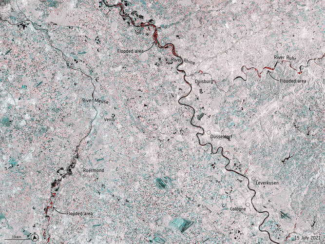 Image:
Record rainfall has caused swollen rivers to burst their banks and wash away homes and other buildings in western Europe. Data from the Copernicus Sentinel-1 mission are being used to map flooded areas to help relief efforts.
Image:
Record rainfall has caused swollen rivers to burst their banks and wash away homes and other buildings in western Europe. Data from the Copernicus Sentinel-1 mission are being used to map flooded areas to help relief efforts.
odborný referent/vrchní referent – návrh zápisu v katastru,
16.7.2021 14:32 ČÚZK - volná místa Katastrální úřad pro hlavní město Prahu - Katastrální pracoviště Praha vypisuje výběrové řízení na místo odborný referent/vrchní referent – návrh zápisu v katastru,odborný referent/vrchní referent – návrh zápisu v katastru,
16.7.2021 14:32 ČÚZK - předpisy a opatření Katastrální úřad pro hlavní město Prahu - Katastrální pracoviště Prahavypisuje výběrové řízení na místo
odborný referent/vrchní referent – návrh zápisu v katastru,
odborný referent/vrchní referent – návrh zápisu v katastru,
16.7.2021 14:32 ČÚZK /Urady/Katastralni-urady/Katastralni-urady/Katastralni-urad-pro-hlavni-mesto-Prahu/Uredni-deska/Oznameni-a-jina-uredni-sdeleni/Volna-mista/DMS/odborny-referent-vrchni-referent-–-navrh-zapisu-vERS: 30 years of outstanding achievements
16.7.2021 11:30 ESA Observing the Earth
ESA’s first Earth observation mission dedicated to understanding our planet, the European Remote Sensing satellite (ERS-1), was launched into orbit on 17 July 1991 – almost 30 years ago today. At the time of its launch, the ERS satellite was one of the most sophisticated spacecraft ever developed and launched by Europe, paving the way for satellite technology in the areas of atmosphere, land, ocean and ice monitoring. Today, we look back at some of the mission’s key accomplishments.
GeoSocial Networking Forum – Example
16.7.2021 11:19 Satlab GeosolutionsPhasellus tempus rhoncus sem, vitae posuere est commodo tempor. Etiam non nulla sed nisl porttitor suscipit vel sed augue. Nullam vitae nisl arcu. Curabitur non mattis ipsum. Aliquam euismod faucibus odio, id lacinia enim rutrum in.
The post GeoSocial Networking Forum – Example appeared first on SatLab – Global Satellite Positioning Solutions.
#MyGalileoSolution winner 10Lines hits the mark and signs deal with Tera Ventures capital
16.7.2021 10:02 European GNSS Agency
The Galileo-enabled autonomous parking lot solution from Estonia signed a 700.000 euro deal with Tera Ventures to scale up in Europe and the US, and to expand to road, airports, and harbours markings too.
10Lines is an Estonian start-up led by Tarmo Prints and Janno Paas that uses autonomous robots to deliver high calibre surface marking for parking lots. To do so, the company’s robots use Galileo’s additional accuracy in combination with other sensors to offer a positioning down to 1-2cm. 10Lines robots can strip parking lots seven times faster than current processes, require less supervision, eliminate the time-consuming measuring and pre-marking phases while significantly reducing CO2 emissions.
Moreover, 10Lines allows users to map sites digitally and set the robot in motion, cutting out much of the measuring and pre-marking process that currently accounts for 70% of the time required to mark parking lots, while at the same time reducing errors.
The European start-up recently raised €700,000 in a seed round led by Estonian venture capital firm Tera Ventures with co-investment from US investor Perot Jain. The deal will further facilitate the development and production of the solution as well as jumpstart the scaling and the expansion of the team in the EU and across the pond.
‘’I am excited to see one of the innovative start-ups of our network that leverages Galileo’s increased performances spreading its wings! These are the kind of solutions we need in Europe, especially within the EU Green Deal context. This project touches both the green and the digital transition that are set out in the pact. Way to go 10Lines’’ said Fiammetta Diani, Head of Market Development at EUSPA.
10Lines won the first prize of the EUSPA-organized MyGalileoSolution Track 2 competition that was concluded in early 2021, worth a total €100,000.
Media note: This feature can be republished without charge provided the European Union Agency for the Space Programme (EUSPA) is acknowledged as the source at the top or the bottom of the story. You must request permission before you use any of the photographs on the site. If you republish, we would be grateful if you could link back to the EUSPA website (http://www.euspa.europa.eu).
#MyGalileoSolution winner 10Lines hits the mark and signs deal with Tera Ventures capital
16.7.2021 10:02 European GNSS AgencyThe Galileo-enabled autonomous parking lot solution from Estonia signed a 700.000 euro deal with Terra Ventures to scale up in Europe and the US, and to expand to road, airports, and harbours markings too.
10Lines is an Estonian start-up led by Tarmo Prints and Jano Paas that uses autonomous robots to deliver high calibre surface marking for parking lots. To do so, the company’s robots use Galileo’s additional accuracy in combination with other sensors to offer a positioning down to 1-2cm. 10Lines robots can strip parking lots seven times faster than current processes, require less supervision, eliminate the time-consuming measuring and pre-marking phases while significantly reducing CO2 emissions.
Moreover, 10Lines allows users to map sites digitally and set the robot in motion, cutting out much of the measuring and pre-marking process that currently accounts for 70% of the time required to mark parking lots, while at the same time reducing errors.
The European start-up recently raised €700,000 in a seed round led by Estonian venture capital firm Tera Ventures with co-investment from US investor Perot Jain. The deal will further facilitate the development and production of the solution as well as jumpstart the scaling and the expansion of the team in the EU and across the pond.
‘’I am excited to see one of the innovative start-ups of our network that leverages Galileo’s increased performances spreading its wings! These are the kind of solutions we need in Europe, especially within the EU Green Deal context. This project touches both the green and the digital transition that are set out in the pact. Way to go 10Lines’’ said Fiammetta Diani, Head of Market Development at EUSPA.
10Lines won the first prize of the EUSPA-organized MyGalileoSolution Track 2 competition that was concluded in early 2021, worth a total €100,000.
Media note: This feature can be republished without charge provided the European Union Agency for the Space Programme (EUSPA) is acknowledged as the source at the top or the bottom of the story. You must request permission before you use any of the photographs on the site. If you republish, we would be grateful if you could link back to the EUSPA website (http://www.euspa.europa.eu).
#MyGalileoSolution winner 10Lines hits the mark and signs deal with Terra Ventures capital
16.7.2021 10:02 European GNSS AgencyThe Galileo-enabled autonomous parking lot solution from Estonia signed a 700.000 euro deal with Terra Ventures to scale up in Europe and the US, and to expand to road, airports, and harbours markings too.
10Lines is an Estonian start-up led by Tarmo Prints and Jano Paas that uses autonomous robots to deliver high calibre surface marking for parking lots. To do so, the company’s robots use Galileo’s additional accuracy in combination with other sensors to offer a positioning down to 1-2cm. 10Lines robots can strip parking lots seven times faster than current processes, require less supervision, eliminate the time-consuming measuring and pre-marking phases while significantly reducing CO2 emissions.
Moreover, 10Lines allows users to map sites digitally and set the robot in motion, cutting out much of the measuring and pre-marking process that currently accounts for 70% of the time required to mark parking lots, while at the same time reducing errors.
The European start-up recently raised €700,000 in a seed round led by Estonian venture capital firm Tera Ventures with co-investment from US investor Perot Jain. The deal will further facilitate the development and production of the solution as well as jumpstart the scaling and the expansion of the team in the EU and across the pond.
‘’I am excited to see one of the innovative start-ups of our network that leverages Galileo’s increased performances spreading its wings! These are the kind of solutions we need in Europe, especially within the EU Green Deal context. This project touches both the green and the digital transition that are set out in the pact. Way to go 10Lines’’ said Fiammetta Diani, Head of Market Development at EUSPA.
10Lines won the first prize of the EUSPA-organized MyGalileoSolution Track 2 competition that was concluded in early 2021, worth a total €100,000.
Media note: This feature can be republished without charge provided the European Union Agency for the Space Programme (EUSPA) is acknowledged as the source at the top or the bottom of the story. You must request permission before you use any of the photographs on the site. If you republish, we would be grateful if you could link back to the EUSPA website (http://www.euspa.europa.eu).
#MyGalileoSolution winner 10Lines hits the mark and signs deal with Tera Ventures capital
16.7.2021 10:02 European GNSS AgencyThe Galileo-enabled autonomous parking lot solution from Estonia signed a 700.000 Euro deal with Tera Ventures to scale up in Europe and the US, and to expand to road, airports, and harbours markings too.
10Lines is an Estonian start-up led by Tarmo Prints and Janno Paas that uses autonomous robots to deliver high calibre surface marking for parking lots. To do so, the company’s robots use Galileo’s additional accuracy in combination with other sensors to offer a positioning down to 1-2cm. 10Lines robots can strip parking lots seven times faster than current processes, require less supervision, eliminate the time-consuming measuring and pre-marking phases while significantly reducing CO2 emissions.
Moreover, 10Lines allows users to map sites digitally and set the robot in motion, cutting out much of the measuring and pre-marking process that currently accounts for 70% of the time required to mark parking lots, while at the same time reducing errors.
The European start-up recently raised €700,000 in a seed round led by Estonian venture capital firm Tera Ventures with co-investment from US investor Perot Jain. The deal will further facilitate the development and production of the solution as well as jumpstart the scaling and the expansion of the team in the EU and across the pond.
‘’I am excited to see one of the innovative start-ups of our network that leverages Galileo’s increased performances spreading its wings! These are the kind of solutions we need in Europe, especially within the EU Green Deal context. This project touches both the green and the digital transition that are set out in the pact. Way to go 10Lines’’ said Fiammetta Diani, Head of Market Development at EUSPA.
10Lines won the first prize of the EUSPA-organized MyGalileoSolution Track 2 competition that was concluded in early 2021, worth a total €100,000.
Media note: This feature can be republished without charge provided the European Union Agency for the Space Programme (EUSPA) is acknowledged as the source at the top or the bottom of the story. You must request permission before you use any of the photographs on the site. If you republish, we would be grateful if you could link back to the EUSPA website (http://www.euspa.europa.eu).
#MyGalileoSolution winner 10Lines hits the mark and signs deal with Tera Ventures capital
16.7.2021 10:02 European GNSS AgencyThe Galileo-enabled autonomous parking lot solution from Estonia signed a 700.000 euro deal with Tera Ventures to scale up in Europe and the US, and to expand to road, airports, and harbours markings too.
10Lines is an Estonian start-up led by Tarmo Prints and Jano Paas that uses autonomous robots to deliver high calibre surface marking for parking lots. To do so, the company’s robots use Galileo’s additional accuracy in combination with other sensors to offer a positioning down to 1-2cm. 10Lines robots can strip parking lots seven times faster than current processes, require less supervision, eliminate the time-consuming measuring and pre-marking phases while significantly reducing CO2 emissions.
Moreover, 10Lines allows users to map sites digitally and set the robot in motion, cutting out much of the measuring and pre-marking process that currently accounts for 70% of the time required to mark parking lots, while at the same time reducing errors.
The European start-up recently raised €700,000 in a seed round led by Estonian venture capital firm Tera Ventures with co-investment from US investor Perot Jain. The deal will further facilitate the development and production of the solution as well as jumpstart the scaling and the expansion of the team in the EU and across the pond.
‘’I am excited to see one of the innovative start-ups of our network that leverages Galileo’s increased performances spreading its wings! These are the kind of solutions we need in Europe, especially within the EU Green Deal context. This project touches both the green and the digital transition that are set out in the pact. Way to go 10Lines’’ said Fiammetta Diani, Head of Market Development at EUSPA.
10Lines won the first prize of the EUSPA-organized MyGalileoSolution Track 2 competition that was concluded in early 2021, worth a total €100,000.
Media note: This feature can be republished without charge provided the European Union Agency for the Space Programme (EUSPA) is acknowledged as the source at the top or the bottom of the story. You must request permission before you use any of the photographs on the site. If you republish, we would be grateful if you could link back to the EUSPA website (http://www.euspa.europa.eu).
#MyGalileoSolution winner 10Lines hits the mark and signs deal with Tera Ventures capital
16.7.2021 10:02 European GNSS AgencyThe Galileo-enabled autonomous parking lot solution from Estonia signed a 700.000 euro deal with Tera Ventures to scale up in Europe and the US, and to expand to road, airports, and harbours markings too.
10Lines is an Estonian start-up led by Tarmo Prints and Jano Paas that uses autonomous robots to deliver high calibre surface marking for parking lots. To do so, the company’s robots use Galileo’s additional accuracy in combination with other sensors to offer a positioning down to 1-2cm. 10Lines robots can strip parking lots seven times faster than current processes, require less supervision, eliminate the time-consuming measuring and pre-marking phases while significantly reducing CO2 emissions.
Moreover, 10Lines allows users to map sites digitally and set the robot in motion, cutting out much of the measuring and pre-marking process that currently accounts for 70% of the time required to mark parking lots, while at the same time reducing errors.
The European start-up recently raised €700,000 in a seed round led by Estonian venture capital firm Tera Ventures with co-investment from US investor Perot Jain. The deal will further facilitate the development and production of the solution as well as jumpstart the scaling and the expansion of the team in the EU and across the pond.
‘’I am excited to see one of the innovative start-ups of our network that leverages Galileo’s increased performances spreading its wings! These are the kind of solutions we need in Europe, especially within the EU Green Deal context. This project touches both the green and the digital transition that are set out in the pact. Way to go 10Lines’’ said Fiammetta Diani, Head of Market Development at EUSPA.
10Lines won the first prize of the EUSPA-organized MyGalileoSolution Track 2 competition that was concluded in early 2021, worth a total €100,000.
Media note: This feature can be republished without charge provided the European Union Agency for the Space Programme (EUSPA) is acknowledged as the source at the top or the bottom of the story. You must request permission before you use any of the photographs on the site. If you republish, we would be grateful if you could link back to the EUSPA website (http://www.euspa.europa.eu).
Earth from Space: Lima, Peru
16.7.2021 10:00 ESA Observing the Earth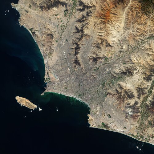
Lima, the capital and largest city of Peru, is featured in this Copernicus Sentinel-2 image.
Earth from Space: Lima, Peru
16.7.2021 10:00 ESA Observing the Earth
Lima, the capital and largest city of Peru, is featured in this Copernicus Sentinel-2 image.
Inženýrský den 2021 – Digitalizace ve stavebnictví. Program konference ČKAIT a ČSSI
16.7.2021 9:17 Zeměměřič21. ročník konference ČKAIT a ČSSI se netradičně uskuteční 22. září 2021, tradičně ale na Fakultě stavební VUT v Brně. Cílem konference je poskytnout komplexní pohled na digitalizaci ve stavebnictví z pohledu právních předpisů a praxe. Témata přednášek jsou koncipována tak, aby přiblížila celou šíři problematiky od portálu stavebníka, současně platných právních předpisů, naplňování koncepce BIM v ČR, elektronického podpisu autorizovaných osob […]
The post Inženýrský den 2021 – Digitalizace ve stavebnictví. Program konference ČKAIT a ČSSI appeared first on Zeměměřič.
Bluesky and BlackSky Join Forces to Bring Satellite Imagery to the U.K.
16.7.2021 9:00 GISCafe.com Webcasts-Webinars Leicestershire, UK, 13 July 2021 - Bluesky International (Bluesky), the leading aerial survey company in the U.K. and Republic of Ireland, has …Open Maps For Europe project confirms coverage for first data release
16.7.2021 9:00 GISCafe.com Webcasts-Webinars Open Maps For Europe has confirmed coverage for its first release of open data later this summer.EuroGeographics, which is coordinating the project …
Výběrové řízení
16.7.2021 7:35 ČÚZK - předpisy a opatření Katastrální úřad pro Plzeňský kraj - Katastrální pracoviště Klatovy zveřejnil novou aktualitu: Ředitelka Katastrálního úřadu pro Plzeňský kraj vyhlašuje výběrové řízení na služební místo vrchní referent/rada – řízení o údajích SGI RUSGI0601, oddělení dokumentace KN, Katastrální úřad pro Plzeňský kraj, Katastrální pracoviště Klatovy, v oboru služby 55. Zeměměřictví a katastr nemovitostí.vrchní referent/rada – řízení o údajích SGI
16.7.2021 7:28 ČÚZK - volná místa Katastrální úřad pro Plzeňský kraj Katastrální pracoviště Klatovy vypisuje výběrové řízení na místo vrchní referent/rada – řízení o údajích SGIvrchní referent/rada – řízení o údajích SGI
16.7.2021 7:28 ČÚZK /Urady/Katastralni-urady/Katastralni-urady/Katastralni-urad-pro-Plzensky-kraj/Uredni-deska/Oznameni-a-jina-uredni-sdeleni/Volna-mista/DMS/vrchni-referent-rada-–-rizeni-o-udajich-SGIvrchní referent/rada – řízení o údajích SGI
16.7.2021 7:28 ČÚZK - předpisy a opatření Katastrální úřad pro Plzeňský kraj Katastrální pracoviště Klatovyvypisuje výběrové řízení na místo
vrchní referent/rada – řízení o údajích SGI
Esri Commends European Union's Open Data Directive
16.7.2021 2:32 GISCafe.com Webcasts-Webinars New Legal Requirements Enable Collaboration among EU GIS CommunityREDLANDS, Calif. — (BUSINESS WIRE) — July 15, 2021 —
Esri, the …
SJI Honored for Special Achievement in GIS
16.7.2021 2:31 GISCafe.com Webcasts-Webinars Geographic Information System Provider Esri Awards SJI at Virtual User ConferenceFOLSOM, NJ—July 15, 2021— Esri, the global leader in …