


![]()

zprávy
zdroje zpráv:NextBillion.ai Recognized on Fast Company’s 2021 World’s Most Innovative Companies List
11.3.2021 17:02 GISCafe.com Webcasts-Webinars AI-powered mapping platform for enterprises among top-ranked in the Most Innovative Company Asia-Pacific categorySAN FRANCISCO, Calif. – …
Panzura Makes Threat Detection Simple, Boosts Security with Release of CloudFS 8 Defend
11.3.2021 17:01 GISCafe.com Webcasts-Webinars Latest Product Update Provides Seamless Integration with Varonis, Next Generation Alerts and Warnings Relieve IT Security Blind SpotsSAN JOSE, …
Trimble and VayaVision Establish Alliance to Make Intelligent Automation Even Smarter
11.3.2021 17:01 GISCafe.com Webcasts-Webinars Working Together to Optimize Path Planning, Obstacle Avoidance and Situational Awareness for Autonomous Vehicles and MachinesSUNNYVALE, Calif., …
HSR.health Aids Global Pandemic Response with Unmatched Geospatial Data Analytics
11.3.2021 17:01 GISCafe.com Webcasts-Webinars First-in-Market Cloud Platform for Government Agencies & Risk-Based Industries Continues to Gain Traction While Improving Global Pandemic Response & …Satellogic Partners with Leading US and International Space Organizations
11.3.2021 17:01 GISCafe.com Webcasts-Webinars With US expansion, Satellogic joins United States Geospatial Intelligence Foundation, Intelligence and National Security Alliance, SmallSat Alliance, …Axon and Skydio Partner to Bring US-Manufactured, AI-Powered Autonomous Drones to Public Safety
11.3.2021 17:01 GISCafe.com Webcasts-Webinars Exclusive partnership unlocks breakthrough real-time situational awareness with autonomous dronesSEATTLE, March 11, 2021 — (PRNewswire) …
Gravity mission still unearthing hidden secrets
11.3.2021 14:40 ESA Observing the Earth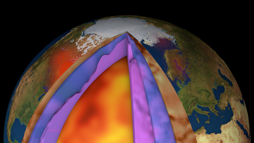
Despite ESA’s GOCE mission ending over seven years ago, scientists continue to use this remarkable satellite’s gravity data to delve deep and unearth secrets about our planet. Recent research shows how scientists have combined GOCE data with measurements taken at the surface to generate a new model of Earth’s crust and upper mantle. This is the first time such a model has been created this way – and it is shedding new light on processes of plate tectonics, which, in turn, are related to phenomena such as earthquakes and volcanic eruptions.
IDX BEAM Analysis – statika nosníků
11.3.2021 14:14 ŠPINAR - softwarepro návrh a statické výpočty nosíků (zatížení, podpory, momenty, posouvající síly, kroutící momenty, torzní momenty, rovnoměrné zatížení...)
The post IDX BEAM Analysis – statika nosníků appeared first on ŠPINAR – software.
IDX BEAM Analysis pro statiku nosníků
11.3.2021 14:14 ŠPINAR - softwareVážení zákazníci,
máme pro Vás připravený program IDX Beam Analysis Tool js TurboCAD Platinum 26 v akční ceně do 18.3.2021
The post IDX BEAM Analysis pro statiku nosníků appeared first on ŠPINAR – software.
IDX BEAM Analysis – statika nosníků
11.3.2021 14:14 ŠPINAR - software pro návrh a statické výpočty nosíků (zatížení, podpory, momenty, posouvající síly, kroutící momenty, torzní momenty, rovnoměrné zatížení...)dočasné uzavření kontaktního místa
11.3.2021 13:13 ČÚZK - předpisy a opatření Katastrální úřad pro Vysočinu - Katastrální pracoviště Žďár nad Sázavou zveřejnil novou aktualitu: Katastrální úřad pro Vysočinu, Katastrální pracoviště Žďár nad Sázavou oznamuje, že od 15. 3. 2021 bude Kontaktní místo Bystřice nad Pernštejnem z provozních důvodů uzavřeno do odvolání.V případě potřeby se obracejte na podatelnu Katastrálního pracoviště Žďár nad Sázavou, se sídlem Strojírenská 8, 591 27 Žďár nad Sázavou. Děkujeme za pochopení.
dočasné uzavření kontaktního místa
11.3.2021 13:13 ČÚZK /Urady/Katastralni-urady/Katastralni-urady/Katastralni-urad-pro-Vysocinu/Katastralni-pracoviste/KP-Zdar-nad-Sazavou/O-uradu/Aktuality/docasne-uzavreni-kontaktniho-mistaGalileo Performance Workshop 2021: The highlights
11.3.2021 12:11 European GNSS Agency
The European GNSS Agency (GSA) organised an online workshop on 3 March to provide an in-depth analysis of the performance of Galileo and show how this performance is evaluated and how it is crucial for service provision in every user application.
The workshop focused in particular on the Galileo Open Service (OS) as defined in the OS Service Definition Document (SDD) and the Programme’s needs for performance monitoring against the defined Minimum Performance Levels (MPLs) and Key Performance Indicators (KPIs). Attention was also paid to publicly available data, products and tools that can be used for GNSS monitoring. In addition to the GSA, the workshop involved representatives of the European Commission, the European Space Agency (ESA) and of the EU Member States and gathered nearly 500 participants.
Workshop outcome
At the workshop, a number of technical topics were addressed.
- All presenters confirmed that the Initial Services commitments as described in the OS SDD are met, some events were observed and discussed, but the Galileo performance, also compared to other GNSS, especially in terms of accuracy is good.
- When monitoring the performance of Galileo, it is important that the satellite health status should be verified for F/NAV and I/NAV ephemerides using broadcast navigation data consolidated from a global network. However, there is no standard on how to generate a consolidated navigation message from publicly available data– the quality and availability depends on latency of this data.
- It is important for users to check the status of the navigation messages as specified in the Galileo OS Signal-in-Space (SiS) Interface Control Document (ICD) and the SDD. This requires that the receivers monitor the Signal-in-Space health flags: signal health status (SHS), data validity status (DVS) and Signal-In-Space accuracy (SISA). The Galileo system uses these three SiS health flags to protect users, and all of them need to be monitored and appropriate actions taken as specified in the ICD. Both the ICD and SDD are available for download on the website of the European GNSS Service Centre (GSC).
Read this: EUSW - status of Galileo services
- With respect to using reference stations for performance monitoring, it is recommended to use a geodetic grade receiver connected to a geodetic antenna. This generates high-quality data using multiple frequencies and signals.
- Real-time data provides an overview of GNSS status in nominal situations. However, not all information from the signals required for monitoring is available in the real-time streams using the RTCM standard. Some sources also provide real-time broadcast orbit and clock corrections in the state space representation (SSR) format, yet unusual events and anomalies might not be reflected properly in these streams, as the underlying processing software might not be able to handle those events well.
- The Galileo Service Operator runs the system to maintain the performance specified in the SDD. Performance may vary within set margins due to operational, maintenance or deployment constraints. In light of this, interpretation of results is key for proper GNSS performance monitoring. It is good practice to make use of redundancy and always to confirm results with other sources, when possible.
Galileo Reference Centre
The GSA has established the Galileo Reference Centre (GRC) with a primary mission of providing an independent means to monitor and evaluate the performance of the Galileo services and the quality of the Signal-in-Space. The GRC is the European hub for these activities, integrating contributions from European national entities, such as research centres, timing laboratories, and national space agencies.
Watch this: Galileo Reference Centre
Performance is measured against Key Performance Indicators (KPIs), the computation of which depends on GNSS data measurements and derived reference products (e.g. precise orbits, satellites clock corrections). It can also be assessed based on publicly available data and products, which exist with various levels of quality, reliability and latency. To be able to compare results obtained by independent sources, it is important to have a common understanding, guidelines for monitoring and a sound assessment methodology. This is what the Galileo performance workshop aims to provide.
All the presentations delivered during the workshop are now available here.
Media note: This feature can be republished without charge provided the European GNSS Agency (GSA) is acknowledged as the source at the top or the bottom of the story. You must request permission before you use any of the photographs on the site. If you republish, we would be grateful if you could link back to the GSA website (http://www.gsa.europa.eu).
Rada/odborný rada v oddělení právních vztahů k nemovitostem na Katastrálním pracovišti Kyov
11.3.2021 11:34 ČÚZK - volná místa Katastrální úřad pro Jihomoravský kraj Katastrální pracoviště Kyjov vypisuje výběrové řízení na místo Rada/odborný rada v oddělení právních vztahů k nemovitostem na Katastrálním pracovišti KyovRada/odborný rada v oddělení právních vztahů k nemovitostem na Katastrálním pracovišti Kyov
11.3.2021 11:34 ČÚZK /Urady/Katastralni-urady/Katastralni-urady/Katastralni-urad-pro-Jihomoravsky-kraj/Uredni-deska/Oznameni-a-jina-uredni-sdeleni/Volna-mista/DMS/Rada-odborny-rada-v-oddeleni-pravnich-vztahu-k-nemRada/odborný rada v oddělení právních vztahů k nemovitostem na Katastrálním pracovišti Kyov
11.3.2021 11:34 ČÚZK - předpisy a opatření Katastrální úřad pro Jihomoravský kraj Katastrální pracoviště Kyjovvypisuje výběrové řízení na místo
Rada/odborný rada v oddělení právních vztahů k nemovitostem na Katastrálním pracovišti Kyov
Rada/odborný rada v oddělení právních vztahů k nemovitostem na Katastrálním pracovišti Kyov
11.3.2021 11:34 ČÚZK - předpisy a opatření Katastrální úřad pro Jihomoravský kraj Katastrální pracoviště Kyjovvypisuje výběrové řízení na místo
Rada/odborný rada v oddělení právních vztahů k nemovitostem na Katastrálním pracovišti Kyjov
Aplikace pro modelování dostupnosti v Jihomoravském kraji (TZ)
11.3.2021 8:52 GISportal.cz
Nejen naše planeta, ale i region mají omezené zdroje, což nevyhnutelně vede k potřebě intenzivního využívání veřejné hromadné dopravy jako alternativy k osobní automobilové přepravě. V Brně a okolí byl proto zaveden Integrovaný dopravní systém Jihomoravského kraje (IDS JMK), který poskytuje levnou, rychlou, spolehlivou a ekologickou možnost přepravy pro 1,2 milionů lidí. Má 161 zón, víc jak […]
The post Aplikace pro modelování dostupnosti v Jihomoravském kraji (TZ) appeared first on GISportal.cz.
MawisPhoto podpořila Evropská unie
11.3.2021 8:39 Hrdlička Operační program Podnikání a inovace pro konkurenceschopnost pomohl MawisPhotu.NV5 Announces $150 Million Proposed Public Offering of Common Stock
11.3.2021 1:29 GISCafe.com Webcasts-Webinars HOLLYWOOD, Fla., March 10, 2021 (GLOBE NEWSWIRE) -- NV5 Global, Inc. (the “Company” or “NV5”) (Nasdaq: NVEE), a provider of compliance, …New Leica CityMapper-2L configuration enables digital twin creation of cities in complex weather and congested flight operation areas
10.3.2021 22:30 GISCafe.com Webcasts-Webinars With a new focal length combination for ultra-high resolution projects or operations when low flying altitude is required, the Leica CityMapper-2 now …VSI, The Leading Researcher of Active Safety and Automated Vehicle Technologies, Issues Independent Report Verifying AEye LiDAR Performance
10.3.2021 19:34 GISCafe.com Webcasts-Webinars AEye Sets New Standards for LiDAR Range, Resolution and Speed - Powering the Next Generation of Automotive and Trucking Highway ADAS …Technology Innovation Institute’s Secure Systems Research Centre Partners with Purdue University on Game-Changing UAV Security Project
10.3.2021 19:34 GISCafe.com Webcasts-Webinars ABU DHABI, United Arab Emirates — (BUSINESS WIRE) — March 10, 2021 — Technology Innovation Institute (TII), the applied research …Technology Innovation Institute’s Secure Systems Research Centre Partners with Purdue University on Game-Changing UAV Security Project
10.3.2021 19:34 GISCafe.com Webcasts-Webinars ABU DHABI, United Arab Emirates — (BUSINESS WIRE) — March 10, 2021 —Technology Innovation Institute (TII), the applied research …
AgEagle Aerial Systems Expands Business Development Team with Key Hires of Accomplished Drone Industry Veterans
10.3.2021 19:34 GISCafe.com Webcasts-Webinars Paul Allen Named Vice President of Business Development, Drone Solutions andMaribeth Forst Named Director of Business Development, Drone Solutions …Optibus Raises $107 Million and Launches Geospatial Suite to Help Cities Shape the Future of Urban Mobility
10.3.2021 19:34 GISCafe.com Webcasts-Webinars TEL AVIV, Israel, March 10, 2021 — (PRNewswire) — Optibus, the cloud-native AI platform for planning and operating mass …Kässbohrer Signs Multi-Year Supply Agreement with Ouster
10.3.2021 19:34 GISCafe.com Webcasts-Webinars Ski Slope Maintenance Application demonstrates extreme cold weather operating capabilities of Ouster’s digital lidar technologySAN FRANCISCO …
Dataiku and UAVIA Collaboration Successfully Deploys Machine Learning Models for Edge Computing on Drones
10.3.2021 19:34 GISCafe.com Webcasts-Webinars Technology breakthrough signifies massive potential for the future of aerial inspection use casesNEW YORK & PARIS — (BUSINESS WIRE) …
Sagetech Avionics and American Aerospace Sign MOU to Integrate Detect and Avoid System
10.3.2021 19:34 GISCafe.com Webcasts-Webinars The resulting certifiable prototype will fly on the American Aerospace ISR AiRanger in Q1 2022.WHITE SALMON, Wash., March 10, 2021 — …
BMO declares climate ambition
10.3.2021 19:34 GISCafe.com Webcasts-Webinars TORONTO, March 10, 2021 — (PRNewswire) — "There is a pressing need for action to address climate change by reducing greenhouse gas …20210310_Odborný referent oddělení právních vztahů k nemovitostem
10.3.2021 13:43 ČÚZK - předpisy a opatření Katastrální úřad pro Středočeský kraj - Katastrální pracoviště Kladno Vyhlášení výběrového řízení: Odborný referent oddělení právních vztahů k nemovitostem V části "Úřední deska", v sekci "Oznámení a jiná úřední sdělení" bylo vystaveno "Oznámení o vyhlášení výběrového řízení na obsazení služebního místa Odborný referent oddělení právních vztahů k nemovitostem"20210310_Odborný referent oddělení právních vztahů k nemovitostem
10.3.2021 13:43 ČÚZK /Urady/Katastralni-urady/Katastralni-urady/Katastralni-urad-pro-Stredocesky-kraj/Katastralni-pracoviste/KP-Kladno/O-uradu/Aktuality/20210113_odborny-rada,-reditel-Katastralniho-pracoHow Galileo performed first-ever authenticated positioning fix
10.3.2021 12:40 ESA Navigation
In a first for any satellite navigation system, Galileo has achieved the first positioning fix based on open-service navigation signals carrying authenticated data. Intended as a way to combat malicious ‘spoofing’ of satnav signals, this authentication testing began at ESA’s Navigation Laboratory – the same site where the very first Galileo positioning fix took place back in 2013.
How Galileo performed first-ever authenticated positioning fix
10.3.2021 12:40 ESA Navigation
In a first for any satellite navigation system, Galileo has achieved a positioning fix based on open-service navigation signals carrying authenticated data. Intended as a way to combat malicious ‘spoofing’ of satnav signals, this authentication testing began at ESA’s Navigation Laboratory – the same site where the very first Galileo positioning fix took place back in 2013.
Galileo satellite performs collision avoidance manoeuvre
10.3.2021 12:37 European GNSS Agency
Under the management of the European GNSS Agency (GSA), a collision avoidance manoeuvre for satellite GSAT0219 was performed over the past weekend. This manoeuvre was conducted following a collision risk alert received from EU Space Surveillance and Tracking (EUSST).
On 25 February, the Galileo Service Operator (GSOp) received from the EUSST a collision risk alert between GSAT0219 and an inert Ariane 4 upper stage launched in 1989. Following this warning, GSOp started to closely monitor the risk, in close cooperation with EUSST that was refining its predictions.
In line with operational procedures, GSOp informed the GSA of the situation. In a joint effort with the European Commission, the GSA managed the follow-up activities. The effective cooperation between EUSST and the GSA/GSOp was instrumental to the success of the mission and bears testimony to the need for efficient cooperation between different organisations in the space sector.
Manoeuvre authorised
Following refinement of the Ariane 4 orbit, the risk of collision was still unacceptably high, so, after assessment of different strategies and associated risks on the service provision, the GSA authorised the execution of an avoidance manoeuvre. The satellite was taken out of service on 5 March, and users were informed via NAGU #2021009. The collision avoidance manoeuvre was performed shortly thereafter, by temporarily relocating the satellite away from its nominal position. Satellite GSAT0219 is expected to be reintroduced into service in Calendar Week 11 (15.03 – 21.03) after the completion of two station keeping manoeuvres to reposition it into its nominal operational orbit. Users will be kept informed via NAGUs.
This is the first time a collision avoidance manoeuvre has been performed for a satellite in the Galileo constellation.
Interview with Paige Cutland, VP Marketing, Kongsberg Geospatial
10.3.2021 9:00 GISCafe.com Webcasts-WebinarsJak měřit a porovnávat atraktivitu regionů (webinář)
10.3.2021 8:52 GISportal.cz
Atraktivita regionů je jedním z faktorů, které hodnotí význam geografických oblastí, jejich konkurenceschopnost, přitažlivost pro různé formy podnikání a také potenciál pro spolupráci. Webinář, který se koná 16. března od 13:00, představí atraktivitu regionů zjišťovanou na základě statistických dat (tzv. evidence-based přístup). Atraktivita regionů je relativně subjektivní pohled a z pohledu různých jedinců a organizací […]
The post Jak měřit a porovnávat atraktivitu regionů (webinář) appeared first on GISportal.cz.
vrchní referent / rada v oddělení dokumentace katastru nemovitostí Katastrálního pracoviště Ústí nad
10.3.2021 8:38 ČÚZK /Urady/Katastralni-urady/Katastralni-urady/Katastralni-urad-pro-Pardubicky-kraj/Uredni-deska/Oznameni-a-jina-uredni-sdeleni/Volna-mista/vrchni-referent-rada-v-oddeleni-dokumentace-ka-(2)vrchní referent / rada v oddělení dokumentace katastru nemovitostí Katastrálního pracoviště Ústí nad
10.3.2021 8:38 ČÚZK - volná místa Katastrální úřad pro Pardubický kraj - Katastrální pracoviště Ústí nad Orlicí vypisuje výběrové řízení na místo vrchní referent / rada v oddělení dokumentace katastru nemovitostí Katastrálního pracoviště Ústí nadvrchní referent / rada v oddělení dokumentace katastru nemovitostí Katastrálního pracoviště Ústí nad
10.3.2021 8:38 ČÚZK - předpisy a opatření Katastrální úřad pro Pardubický kraj - Katastrální pracoviště Ústí nad Orlicívypisuje výběrové řízení na místo
vrchní referent / rada v oddělení dokumentace katastru nemovitostí Katastrálního pracoviště Ústí nad Orlicí
AeroVironment, Inc. Announces Fiscal 2021 Third Quarter Results
10.3.2021 0:13 GISCafe.com Webcasts-Webinars SIMI VALLEY, Calif. — (BUSINESS WIRE) — March 9, 2021 —AeroVironment, Inc. (NASDAQ: AVAV), a global leader in unmanned aircraft …
AeroVironment Wholly-Owned Subsidiary Arcturus UAV Awarded Approximately $7 Million Task Order for U.S. Special Operations Command Mid-Endurance Unmanned Aircraft Systems Program
10.3.2021 0:13 GISCafe.com Webcasts-Webinars Competitive task order awarded for USSOCOM’s Mid-Endurance Unmanned Aircraft Systems (MEUAS) programVertical takeoff and landing (VTOL) JUMP 20 …
Draganfly Enters Agreement with Applied Research and Innovations Services at Southern Alberta Institute of Technology to Advance UAV Delivery Technology
10.3.2021 0:13 GISCafe.com Webcasts-Webinars Los Angeles, CA., March 09, 2021 (GLOBE NEWSWIRE) -- Draganfly Inc. (OTCQB: DFLYF) (CSE: DFLY) (FSE: 3U8) (“Draganfly” or the “Company”), …Knihovna geografie je od 10.3.2021 do odvolání uzavřena [Knihovna geografie, byTopic]
10.3.2021 0:00 Katedra aplikované geoinformatiky a kartografie Přf UK Vzhledem k přijatým opatřením Krizového štábu (KŠ) PřF UK ze dne 9. 3. 2021 v souvislosti s pandemickou situací je Knihovna geografie do odvolání uzavřena.Featured Speakers Announced for the 24th Annual GIS/Valuation Technologies Conference
9.3.2021 21:37 GISCafe.com Webcasts-Webinars Des Plaines, IL (March 9, 2021) URISA and the International Association of Assessing Officers (IAAO) are pleased to announce the featured speakers …Digital Twins can prevent US cities under-reporting their carbon emissions
9.3.2021 21:36 GISCafe.com Webcasts-Webinars Cities across the United States are underreporting their carbon emissions by an average of 18.3% according to Nature Communications, the journal for …OGC Introduces Visiting Fellow Program
9.3.2021 21:19 GISCafe.com Webcasts-Webinars OGC Visiting Fellow(s) will bring diversity to OGC's technical and market thought-leadership, keeping the Consortium responsive and proactive to …Webináře k vybraným službám programu Copernicus
9.3.2021 16:54 CENIA - národní geoportál INSPIRE CENIA, česká informační agentura životního prostředí pořádá sérii webinářů věnovanou vybraným službám programu Copernicus. Série navazuje na odborné semináře CENIA Spatium naturalis per humana vita – Prostředí pro život člověka a rozšiřuje je v oblasti evropského programu pro pozorování Země – Copernicus. Cílem webinářů je seznámit účastníky se službami a produkty programu Copernicus. V rámci...Allvision IO Newest Offering Creates Digital Infrastructure Maps with Enhanced Data
9.3.2021 16:32 GISCafe.com Webcasts-Webinars PITTSBURGH, March 9, 2021 — (PRNewswire) — Allvision IO, a geospatial analytics company providing insights and asset management to the …A Look Back: US Mortgage Delinquency Rates Experience Record Highs and Lows in 2020, CoreLogic Reports
9.3.2021 16:32 GISCafe.com Webcasts-Webinars US overall delinquency shrinks for the fourth straight month in December, ending a rocky year with signs of recoveryIRVINE, Calif. — (BUSINESS …
HawkEye 360 Adds Quintet of Leaders to Advisory Board
9.3.2021 16:32 GISCafe.com Webcasts-Webinars Kevin Chilton, Scott Swift, B. Lynn Wright, Stephanie O'Sullivan and Mac Thornberry boast decades of leadership experience in U.S. military, …ePropelled Unveils The Most Comprehensive Product Line For UAVs On The Market Today
9.3.2021 16:32 GISCafe.com Webcasts-Webinars LOWELL, Mass., March 9, 2021 — (PRNewswire) — ePropelled, the Massachusetts-based technology company offering leading-edge …EarthDefine Uses AI to Map All Built-Up Surfaces and Parking Lots in the United States
9.3.2021 16:32 GISCafe.com Webcasts-Webinars REDMOND, Wash., March 9, 2021 — (PRNewswire) — EarthDefine, a provider of high-resolution geospatial products, announced the release of …Antarctica’s magnetic link to ancient neighbours
9.3.2021 14:47 ESA Observing the Earth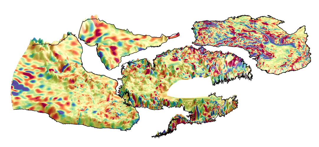
For the first time, an international team of scientists has used magnetic data from ESA’s Swarm satellite mission together with aeromagnetic data to help reveal the mysteries of the geology hidden beneath Antarctica’s kilometres-thick ice sheets, and link Antarctica better to its former neighbours.
20210209_Úprava úředních hodin
9.3.2021 13:07 ČÚZK - předpisy a opatření Katastrální úřad pro Středočeský kraj - Katastrální pracoviště Kolín zveřejnil novou aktualitu: Úprava úředních hodin Úprava úředních hodinZ důvodu epidemiologické situace na pracovišti budou ve dnech 9. 3. 2021 - 26.03.2021 omezeny úřední hodiny na dobu 08:00 - 13:00 hod.
20210209_Úprava úředních hodin
9.3.2021 13:07 ČÚZK - předpisy a opatření Katastrální úřad pro Středočeský kraj - Katastrální pracoviště Kolín zveřejnil novou aktualitu: Úprava úředních hodin Úprava úředních hodinZ důvodu epidemiologické situace na pracovišti budou ve dnech 9. 3. 2021 - 19.03.2021 omezeny úřední hodiny na dobu 08:00 - 13:00 hod.
20210209_Úprava úředních hodin
9.3.2021 13:07 ČÚZK - předpisy a opatření Katastrální úřad pro Středočeský kraj - Katastrální pracoviště Kolín zveřejnil novou aktualitu: Úprava úředních hodin Úprava úředních hodinZ důvodu epidemiologické situace na pracovišti budou ve dnech 3. 3. 2021 - 19.03.2021 omezeny úřední hodiny na dobu 08:00 - 13:00 hod.
20210209_Úprava úředních hodin
9.3.2021 13:07 ČÚZK /Urady/Katastralni-urady/Katastralni-urady/Katastralni-urad-pro-Stredocesky-kraj/Katastralni-pracoviste/KP-Kolin/O-uradu/Aktuality/20210209_Uprava-urednich-hodinDalší automatizace zpracování staveb
9.3.2021 12:38 Hrdlička 1.1.2021 byla spuštěna produkční verze EMS21+, Externí Mapové Služby pro společnost EG.D, a.s.Map Viewer Beta
9.3.2021 12:13 blog ARCDATA Nová verze Prohlížeče map, Map Viewer Beta, si svou premiéru odbyla sice již v září 2019, ale od té doby obdržela mnoho nových vylepšení a funkcí. Tento článek vám představí, proč byste si měli Map Viewer Beta vyzkoušet a třeba i začít používat.oznámení o vyhlášení výběrového řízení v právním odd. KP TR
9.3.2021 10:51 ČÚZK /Urady/Katastralni-urady/Katastralni-urady/Katastralni-urad-pro-Vysocinu/O-uradu/Aktuality/oznameni-o-vyhlaseni-vyberoveho-rizeni-v-pravnim-ooznámení o vyhlášení výběrového řízení v právním odd. KP TR
9.3.2021 10:51 ČÚZK - předpisy a opatření Katastrální úřad pro Vysočinu zveřejnil novou aktualitu: Oznámení o vyhlášení výběrového řízení na služební místo odborný referent v oddělení právní vztahy k nemovitostem Katastrálního pracoviště Třebíč na Katastrálním úřadu pro Vysočinu.Odborný referent – obnova katastrálního operátu v oddělení obnovy katastrálního operátu Katastrálníh
9.3.2021 10:49 ČÚZK - volná místa Katastrální úřad pro Zlínský kraj vypisuje výběrové řízení na místo Odborný referent – obnova katastrálního operátu v oddělení obnovy katastrálního operátu KatastrálníhOdborný referent – obnova katastrálního operátu v oddělení obnovy katastrálního operátu Katastrálníh
9.3.2021 10:49 ČÚZK - předpisy a opatření Katastrální úřad pro Zlínský krajvypisuje výběrové řízení na místo
Odborný referent – obnova katastrálního operátu v oddělení obnovy katastrálního operátu Katastrálního úřadu pro Zlínský kraj
Odborný referent – obnova katastrálního operátu v oddělení obnovy katastrálního operátu Katastrálníh
9.3.2021 10:49 ČÚZK /Urady/Katastralni-urady/Katastralni-urady/Katastralni-urad-pro-Zlinsky-kraj/Uredni-deska/Oznameni-a-jina-uredni-sdeleni/Volna-mista/DMS/Odborny-referent-–-obnova-katastralniho-operat-(2)Odborný referent – obnova katastrálního operátu v oddělení obnovy katastrálního operátu Katastrálníh
9.3.2021 10:45 ČÚZK /Urady/Katastralni-urady/Katastralni-urady/Katastralni-urad-pro-Zlinsky-kraj/Uredni-deska/Oznameni-a-jina-uredni-sdeleni/Volna-mista/DMS/Odborny-referent-–-obnova-katastralniho-operat-(1)Odborný referent – obnova katastrálního operátu v oddělení obnovy katastrálního operátu Katastrálníh
9.3.2021 10:45 ČÚZK - předpisy a opatření Katastrální úřad pro Zlínský krajvypisuje výběrové řízení na místo
Odborný referent – obnova katastrálního operátu v oddělení obnovy katastrálního operátu Katastrálního úřadu pro Zlínský kraj
Odborný referent – obnova katastrálního operátu v oddělení obnovy katastrálního operátu Katastrálníh
9.3.2021 10:45 ČÚZK - volná místa Katastrální úřad pro Zlínský kraj vypisuje výběrové řízení na místo Odborný referent – obnova katastrálního operátu v oddělení obnovy katastrálního operátu Katastrálníhodborný referent - právní vztahy k nemovitostem KP Třebíč
9.3.2021 10:12 ČÚZK /Urady/Katastralni-urady/Katastralni-urady/Katastralni-urad-pro-Vysocinu/Uredni-deska/Oznameni-a-jina-uredni-sdeleni/Volna-mista/DMS/odborny-referent-pravni-vztahy-k-nemovitostem-KPodborný referent - právní vztahy k nemovitostem KP Třebíč
9.3.2021 10:12 ČÚZK - volná místa Katastrální úřad pro Vysočinu Katastrální pracoviště Třebíč vypisuje výběrové řízení na místo odborný referent - právní vztahy k nemovitostem KP Třebíčodborný referent - právní vztahy k nemovitostem KP Třebíč
9.3.2021 10:12 ČÚZK - předpisy a opatření Katastrální úřad pro Vysočinu Katastrální pracoviště Třebíčvypisuje výběrové řízení na místo
odborný referent - právní vztahy k nemovitostem KP Třebíč
Contract signed to build Arctic weather satellite
9.3.2021 9:35 ESA Observing the Earth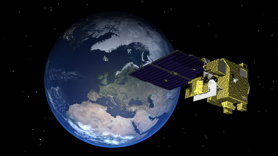
With the need for satellite data to be received more frequently for faster weather forecasting updates in the Arctic, ESA has signed a contract with OHB Sweden to a build prototype satellite for the Arctic Weather Satellite mission.
USGIF Releases Modeling, Simulation, and Gaming Technical Paper
8.3.2021 23:04 GISCafe.com Webcasts-Webinars Advancing the Interoperability of Geospatial Intelligence Tradecraft with 3D Modeling, Simulation, and Game EnginesHerndon, Virginia (March 8, …
Commercial UAV Expo Americas Advisory Board Announced
8.3.2021 23:01 GISCafe.com Webcasts-Webinars Advisory Board Set for Commercial UAV Expo Americas September 7-9, 2021 in Las Vegas23 experts have been tapped to help craft critical programming …€200m European venture capital tech fund launched with a mission to de-carbonize cities.
8.3.2021 23:00 GISCafe.com Webcasts-Webinars A new venture capital fund, 2150, has been launched to invest €200 million ($240 million) in start-up companies developing sustainable …
Odstávka Geoportálu Jihočeského kraje
8.3.2021 17:15 Jihočeský kraj Od středy 10.3.2021 přibližně do pondělí 15.3.2021 nebude možné žádat a vydávat data z Geoportálu z důvodu upgrade aplikačních komponent Geoportálu. Finální termín obnovení možnosti výdejů dat bude zveřejněn zde v aktualitách. Děkujeme za pochopení.Odstávka Geoportálu Jihočeského kraje
8.3.2021 17:15 Jihočeský kraj Od středy 10.3.2021 přibližně do pondělí 15.3.2021 nebude možné žádat a vydávat data z Geoportálu z důvodu upgrade aplikačních komponent Geoportálu. Finální termín obnovení možnosti výdejů dat bude zveřejněn zde v aktualitách. Děkujeme za pochopení.Velodyne Lidar Announces Executive Appointments to Advance Company’s Continued Global Lidar Market Leadership
8.3.2021 16:53 GISCafe.com Webcasts-Webinars Sinclair Vass Named Chief Commercial OfficerMike Jellen Promoted to Chief Strategy Officer
SAN JOSE, Calif. — (BUSINESS WIRE) — March …
GoFor Industries Partners with Aurora Aerial for Drone Delivery Partnership
8.3.2021 16:53 GISCafe.com Webcasts-Webinars Bringing speed and efficiency to the emerging world of alternative last mile delivery technologies, GoFor and Aurora will leverage drones to exceed …DeepSpatial Inc. Gains High Level Sector Expertise on New Advisory Board
8.3.2021 16:53 GISCafe.com Webcasts-Webinars TORONTO — (BUSINESS WIRE) — March 8, 2021 —DeepSpatial Inc. (CSE:DSAI) (“DeepSpatial” or the “Company”) is pleased to …
Telecom seeks better data interoperability as vendors partner with a universal location identifier
8.3.2021 16:53 GISCafe.com Webcasts-Webinars DENVER, March 8, 2021 — (PRNewswire) — Placekey, the universal location identifier for places that launched late last year with …Ondas Holdings Reports Full Year 2020 Financial Results
8.3.2021 16:53 GISCafe.com Webcasts-Webinars Successfully drove early adoption of proprietary wireless connectivity solutions in rail and drone marketsCompleted $34.5 million public offering …
NV5 Awarded $6.6 Million Geospatial Contract by Investor-Owned Utility
8.3.2021 16:53 GISCafe.com Webcasts-Webinars HOLLYWOOD, Fla., March 08, 2021 (GLOBE NEWSWIRE) -- NV5 Global, Inc. (the “Company” or “NV5”) (Nasdaq: NVEE), a provider of compliance, …Ředitel sekce KP Praha
8.3.2021 11:37 ČÚZK /Urady/Katastralni-urady/Katastralni-urady/Katastralni-urad-pro-hlavni-mesto-Prahu/O-uradu/Aktuality/Reditel-sekce-KP-PrahaŘeditel sekce KP Praha
8.3.2021 11:37 ČÚZK - předpisy a opatření Katastrální úřad pro hlavní město Prahu - Katastrální pracoviště Praha zveřejnil novou aktualitu: Ředitel úřadu vyhlašuje výběrové řízení na služební místo:odborný rada – ředitel sekce Katastrální pracoviště Praha Katastrálního úřadu pro hlavní město Prahu
odborný rada – ředitel sekce Katastrální pracoviště Praha Katastrálního úřadu pro hlavní město Prahu
8.3.2021 11:26 ČÚZK - volná místa Katastrální úřad pro hlavní město Prahu Katastrální pracoviště Praha vypisuje výběrové řízení na místo odborný rada – ředitel sekce Katastrální pracoviště Praha Katastrálního úřadu pro hlavní město Prahuodborný rada – ředitel sekce Katastrální pracoviště Praha Katastrálního úřadu pro hlavní město Prahu
8.3.2021 11:26 ČÚZK - předpisy a opatření Katastrální úřad pro hlavní město Prahu - Katastrální pracoviště Prahavypisuje výběrové řízení na místo
odborný rada – ředitel sekce Katastrální pracoviště Praha Katastrálního úřadu pro hlavní město Prahu
odborný rada – ředitel sekce Katastrální pracoviště Praha Katastrálního úřadu pro hlavní město Prahu
8.3.2021 11:26 ČÚZK - volná místa Katastrální úřad pro hlavní město Prahu - Katastrální pracoviště Praha vypisuje výběrové řízení na místo odborný rada – ředitel sekce Katastrální pracoviště Praha Katastrálního úřadu pro hlavní město Prahuodborný rada – ředitel sekce Katastrální pracoviště Praha Katastrálního úřadu pro hlavní město Prahu
8.3.2021 11:26 ČÚZK /Urady/Katastralni-urady/Katastralni-urady/Katastralni-urad-pro-hlavni-mesto-Prahu/Uredni-deska/Oznameni-a-jina-uredni-sdeleni/Volna-mista/DMS/odborny-rada-–-reditel-sekce-Katastralni-pracovistSample of Galileo-enabled wearables: the test results are in!
8.3.2021 11:18 European GNSS Agency
After smartphones, wearables are the second most sold GNSS device, with 70 million shipments in 2019 alone. Given this trend, the European GNSS Agency (GSA) was motivated to test smartwatch devices under various conditions. Three devices were selected that, to a certain extent, characterise the Galileo-enabled device offering on the market in 2020: the Suunto 9, Samsung Galaxy Watch Active 2 and Garmin Fenix 6X PRO. The tests delivered some interesting results.
The tests were carried out by the Airbus Systems Engineering and Technical Assistance (SETA) team under a Galileo System Support contract with the GSA. The main objective was to evaluate the navigation performance of the wearables in different receiver configurations and environments. To evaluate the devices’ performance, the tests assessed positioning accuracy and PVT availability.
All the tests were carried out close to an Airbus site south of Munich, and included an open sky static test, an open sky pedestrian test, and an open sky bike test. In addition, there were three suburban dynamic tests (two pedestrian – one with the watch worn on the wrist and one on a backpack, and one bike test), an urban static test, and two forest dynamic tests (pedestrian and bike), both of which had alternating vegetation of broadleaf trees and conifers.
Read this: Point.IoT 2021 – another year of exciting Galileo-powered IoT innovations
Each test was executed three times in order to cover all the possible GNSS receiver configurations. Subtests with the corresponding GNSS receiver configurations are presented in the table below.

Figure 1: Data collection of forest dynamic pedestrian test case
| Device | Possible GNSS receiver configurations | Release | Single-/Dual-Frequency |
| Suunto 9 |
GPS only GPS + Glonass GPS + Galileo |
June 2018 | SF |
| Samsung Galaxy Watch Active 2 |
There is no option to select constellations. According to the specification receiver supports the following constellations: GPS, Glonass, Beidou and Galileo |
September 2019 | SF |
| Garmin Fenix 6X PRO |
GPS only GPS + Glonass GPS + Galileo |
August 2019 | SF |
Table 1: Wearables under test
Multi-constellation delivers
In general, the devices achieved the highest accuracy when GPS satellites were used together with an additional GNSS. In half of the scenarios, GPS + Galileo showed the best performance.
Suunto 9 outperformed the other two smart-watches in most of the tests by achieving the best positioning accuracy. The PVT availability (up to 90%) of the Suunto 9 was also higher than that of the Garmin and Samsung smartwatches, the only exception being the static scenarios. The results for Suunto 9 are shown in the tables and charts below, demonstrating the achievable performance with the subset of tested devices.
Antenna placement matters for precise testing results
When looking at the best results in terms of accuracy, there is a big difference between wearing the smartwatch on your wrist and having it attached to a backpack. Accuracy is much better when the watch is on a backpack with the watch face, and therefore the GNSS antenna, pointing directly to the sky. The results obtained with the watch worn on the wrist were the worst, because the antenna is not pointing directly at the sky and body shadowing obstructs the signals. This decrease in accuracy could be partially resolved by using higher quality antennas.
| Suunto 9 – suburban test cases | Horizontal accuracy [m] on a given percentile | ||
| Configuration / Watch placement | 50.0% | 63.2% | 95.0% |
| GPS + Galileo / Wrist | 5.29 | 6.31 | 14.74 |
| GPS + Galileo / Backpack | 2.08 | 2.35 | 3.44 |
Table 2: Comparison of Suunto 9 performance (horizontal accuracy under GPS + Galileo configuration) on wrist and backpack
And this: Galileo delivers accuracy; drones deliver solutions
Another solution is to install the antenna outside the smartwatch, so that GNSS signals can reach the antenna directly. This would also reduce the level of interference between the antenna and other components. However, wearing the watch attached to a backpack or using external antenna is not a solution for the vast majority of users. In any case, there is still room for improvement, especially in more challenging environments, but better performance may be achieved with dual-frequency chipsets, soon to be available on the European market, or with higher quality antennas.
Galileo added value
The tests show that Galileo provides added value in terms of accuracy and availability, of which receiver manufacturers are becoming increasingly aware. This added value was clearly demonstrated with the Suunto 9 results: in 52% of the computed statistics, the GPS + Galileo configuration showed better performance than GPS only and GPS + Glonass. This means that, thanks to Galileo, the data collected during users’ activities will be more accurate and allow for improved performance.
Currently over a hundred wearables are benefitting from Galileo’s added accuracy and availability. To check out if your wearable is on the list, click here.

Figure 2: Example of results: Open sky dynamic bike test case – Suunto 9 – horizontal accuracy
| Open sky dynamic bike test case: Suunto 9 | Horizontal accuracy [m] on a given percentile | ||
| Configuration | 50.0% | 63.2% | 95.0% |
| GPS only | 4.20 | 4.76 | 7.45 |
| GPS + Glonass | 4.78 | 5.25 | 7.82 |
| GPS + Galileo | 2.77 | 3.32 | 5.87 |
Table 3: Open sky dynamic bike test case: Suunto 9 – horizontal accuracy on a given percentiles
Media note: This feature can be republished without charge provided the European GNSS Agency (GSA) is acknowledged as the source at the top or the bottom of the story. You must request permission before you use any of the photographs on the site. If you republish, we would be grateful if you could link back to the GSA website (http://www.gsa.europa.eu).
Sample of Galileo-enabled wearables: the test results are in!
8.3.2021 11:18 European GNSS AgencyAfter smartphones, wearables are the second most sold GNSS device, with 70 million shipments in 2019 alone. Given this trend, the European GNSS Agency (GSA) was motivated to test smartwatch devices under various conditions. Three devices were selected that, to a certain extent, characterise the Galileo-enabled device offering on the market in 2020: the Suunto 9, Samsung Galaxy Watch Active 2 and Garmin Fenix 6X PRO. The tests delivered some interesting results.
The tests were carried out by the Airbus Systems Engineering and Technical Assistance (SETA) team under a Galileo System Support contract with the GSA. The main objective was to evaluate the navigation performance of the wearables in different receiver configurations and environments. To evaluate the devices’ performance, the tests assessed positioning accuracy and PVT availability.
All the tests were carried out close to an Airbus site south of Munich, and included an open sky static test, an open sky pedestrian test, and an open sky bike test. In addition, there were three suburban dynamic tests (two pedestrian – one with the watch worn on the wrist and one on a backpack, and one bike test), an urban static test, and two forest dynamic tests (pedestrian and bike), both of which had alternating vegetation of broadleaf trees and conifers.
Read this: Point.IoT 2021 – another year of exciting Galileo-powered IoT innovations
Each test was executed three times in order to cover all the possible GNSS receiver configurations. Subtests with the corresponding GNSS receiver configurations are presented in the table below.
Figure 1: Data collection of forest dynamic pedestrian test case
| Device | Possible GNSS receiver configurations | Release | Single-/Dual-Frequency |
| Suunto 9 |
GPS only GPS + Glonass GPS + Galileo |
June 2018 | SF |
| Samsung Galaxy Watch Active 2 |
There is no option to select constellations. According to the specification receiver supports the following constellations: GPS, Glonass, Beidou and Galileo |
September 2019 | SF |
| Garmin Fenix 6X PRO |
GPS only GPS + Glonass GPS + Galileo |
August 2019 | SF |
Table 1: Wearables under test
Multi-constellation delivers
In general, the devices achieved the highest accuracy when GPS satellites were used together with an additional GNSS. In half of the scenarios, GPS + Galileo showed the best performance.
Suunto 9 outperformed the other two smart-watches in most of the tests by achieving the best positioning accuracy. The PVT availability (up to 90%) of the Suunto 9 was also higher than that of the Garmin and Samsung smartwatches, the only exception being the static scenarios. The results for Suunto 9 are shown in the tables and charts below, demonstrating the achievable performance with the subset of tested devices.
Antenna placement matters for precise testing results
When looking at the best results in terms of accuracy, there is a big difference between wearing the smartwatch on your wrist and having it attached to a backpack. Accuracy is much better when the watch is on a backpack with the watch face, and therefore the GNSS antenna, pointing directly to the sky. The results obtained with the watch worn on the wrist were the worst, because the antenna is not pointing directly at the sky and body shadowing obstructs the signals. This decrease in accuracy could be partially resolved by using higher quality antennas.
| Suunto 9 – suburban test cases | Horizontal accuracy [m] on a given percentile | ||
| Configuration / Watch placement | 50.0% | 63.2% | 95.0% |
| GPS + Galileo / Wrist | 5.29 | 6.31 | 14.74 |
| GPS + Galileo / Backpack | 2.08 | 2.35 | 3.44 |
Table 2: Comparison of Suunto 9 performance (horizontal accuracy under GPS + Galileo configuration) on wrist and backpack
And this: Galileo delivers accuracy; drones deliver solutions
Another solution is to install the antenna outside the smartwatch, so that GNSS signals can reach the antenna directly. This would also reduce the level of interference between the antenna and other components. However, wearing the watch attached to a backpack or using external antenna is not a solution for the vast majority of users. In any case, there is still room for improvement, especially in more challenging environments, but better performance may be achieved with dual-frequency chipsets, soon to be available on the European market, or with higher quality antennas.
Galileo added value
The tests show that Galileo provides added value in terms of accuracy and availability, of which receiver manufacturers are becoming increasingly aware. This added value was clearly demonstrated with the Suunto 9 results: in 52% of the computed statistics, the GPS + Galileo configuration showed better performance than GPS only and GPS + Glonass. This means that, thanks to Galileo, the data collected during users’ activities will be more accurate and allow for improved performance.
Currently over a hundred wearables are benefitting from Galileo’s added accuracy and availability. To check out if your wearable is on the list, click here.
Figure 2: Example of results: Open sky dynamic bike test case – Suunto 9 – horizontal accuracy
| Open sky dynamic bike test case: Suunto 9 | Horizontal accuracy [m] on a given percentile | ||
| Configuration | 50.0% | 63.2% | 95.0% |
| GPS only | 4.20 | 4.76 | 7.45 |
| GPS + Glonass | 4.78 | 5.25 | 7.82 |
| GPS + Galileo | 2.77 | 3.32 | 5.87 |
Table 3: Open sky dynamic bike test case: Suunto 9 – horizontal accuracy on a given percentiles
Media note: This feature can be republished without charge provided the European GNSS Agency (GSA) is acknowledged as the source at the top or the bottom of the story. You must request permission before you use any of the photographs on the site. If you republish, we would be grateful if you could link back to the GSA website (http://www.gsa.europa.eu).
Oznámení o změně úředních hodin
8.3.2021 10:59 ČÚZK - předpisy a opatření Český úřad zeměměřický a katastrální - Katastrální pracoviště Moravské Budějovice zveřejnil novou aktualitu: Od 15. 2. 2021 dochází na katastrálním pracovišti ke změně úředních hodin. Podrobnosti o provozu najdete v tomto dokumentu.Oznámení o změně úředních hodin
8.3.2021 10:59 ČÚZK /Urady/Katastralni-urady/Katastralni-urady/Katastralni-urad-pro-Vysocinu/Katastralni-pracoviste/KP-Moravske-Budejovice/O-uradu/Aktuality/Oznameni-o-zmene-urednich-hodinPřihlášky ke bc. a mgr. studiu jen do 15. 3. 2021
8.3.2021 10:03 Katedra geoinformatiky UP OlomoucJen do 15. března 2021 můžete podávat přihlášky v prvním kole k bakalářskému a magisterskému studiu (prezenčnímu i kombinovanému). Proto neváhejte a podávejte elektronicky na https://prihlaska.upol.cz/prihlaska/info.xhtml
The post Přihlášky ke bc. a mgr. studiu jen do 15. 3. 2021 appeared first on Katedra geoinformatiky.
Vyhlášení veřejných nabídek pozemků pro oprávněné osoby
8.3.2021 0:00 Státní pozemkový úřad 12. 3. 2021 - Vyhlášení dalšího kola veřejných nabídek pozemků pro oprávněné osoby podle zákona č. 229/1991 Sb.Elegantní řešení pro konstruov
8.3.2021 0:00 SolidVision Elegantní řešení pro konstruování, řízení a spolupráci dat na platformě 3DEXPERIENCEElegantní řešení pro konstruov
8.3.2021 0:00 SolidVision Elegantní řešení pro konstruování, řízení a spolupráci dat na platformě 3DEXPERIENCE"GISCafe Voice Industry Predictions for 2021 – Part 5" by Susan Smith
6.3.2021 16:15 GISCafe.com Webcasts-WebinarsVyhlášení The Geospatial World 50 vycházejících hvězd – Jakub Karas
6.3.2021 14:47 Společnost pro fotogrammetrii a dálkový průzkumVážení členové SFDP, nehledě na složitou situaci v ČR máme pro Vás výbornou zprávu. Jakub Karas byl vybrán Geospatial World mezi 50 mladých odborníků ze světa, kteří přispívají významně k rozvoji geoprostorových technologií. Velice Jakube blahopřejeme. Odvětví geoprostorových technologií touží po novém svěžím větru do svých řad. Mladí lídři, kteří představují budoucnost našeho odvětví. Hlasy mladých odborníků zastupující Mileniály a Generaci Z pomáhají přetvážet geoprostor v komplexní digitální prostředí. The Geospatial World 50 vycházejících hvězd je iniciativa společnosti Geospatial Media and Communications s cílem zdůraznit vynikající úspěchy mladých profesionálů, kteří jsou aktivní a nadšeně rozvíjí geoprostorové technololgie v rámci ekonomiky a společnosti. Z 250 nominací vybrala správní rada Geospatial World 50 kandidátů, kteří vynikají ve své kategorii a jsou na dobré cestě stát se lídry ve svém oboru. https://geospatialmedia.net/rising-stars/2021/?utm_source=GW+Subscribers&utm_campaign=f754c7ac55-GW-rising-star-2021-Announcement-mailer-25feb&utm_medium=email&utm_term=0_3b0a203c48-f754c7ac55-139800445
The post Vyhlášení The Geospatial World 50 vycházejících hvězd – Jakub Karas appeared first on SFDP.
Vyhlášení The Geospatial World 50 vycházejících hvězd – Jakub Karas
6.3.2021 14:47 Společnost pro fotogrammetrii a dálkový průzkumVážení členové SFDP, nehledě na složitou situaci v ČR máme pro Vás výbornou zprávu. Jakub Karas byl vybrán Geospatial World mezi 50 mladých odborníků ze světa, kteří přispívají významně k rozvoji geoprostorových technologií. Velice Jakube blahopřejeme. Odvětví geoprostorových technologií touží po novém svěžím větru do svých řad. Mladí lídři, kteří představují budoucnost našeho odvětví. Hlasy mladých odborníků zastupující Mileniály a Generaci Z pomáhají přetvážet geoprostor v komplexní digitální prostředí. The Geospatial World 50 vycházejících hvězd je iniciativa společnosti Geospatial Media and Communications s cílem zdůraznit vynikající úspěchy mladých profesionálů, kteří jsou aktivní a nadšeně rozvíjí geoprostorové technololgie v rámci ekonomiky a společnosti. Z 250 nominací vybrala správní rada Geospatial World 50 kandidátů, kteří vynikají ve své kategorii a jsou na dobré cestě stát se lídry ve svém oboru. https://geospatialmedia.net/rising-stars/2021/?utm_source=GW+Subscribers&utm_campaign=f754c7ac55-GW-rising-star-2021-Announcement-mailer-25feb&utm_medium=email&utm_term=0_3b0a203c48-f754c7ac55-139800445
The post Vyhlášení The Geospatial World 50 vycházejících hvězd – Jakub Karas appeared first on SFDP.
Martin UAV Expands Executive Leadership Team
5.3.2021 17:02 GISCafe.com Webcasts-Webinars Senior Leadership changes accelerate growth strategyPLANO, Texas, March 4, 2021 — (PRNewswire) — Martin UAV, a pioneering advanced …
Ouster and Strategic Manufacturing Partner Benchmark Electronics Accelerate Capacity Expansion to Meet Anticipated 2021 Demand
5.3.2021 17:02 GISCafe.com Webcasts-Webinars Majority of Sensor Production Shifted to Global Contract ManufacturerSAN FRANCISCO — (BUSINESS WIRE) — March 5, 2021 —
Ouster, …
Standard published for remote activation of aircraft distress tracking beacons using the Search and Rescue (SAR) Return Link Service as offered by Galileo
5.3.2021 14:43 European GNSS Agency
The EUROCAE “ED-277 - Minimum Aviation System Performance Standard for Aircraft Emergency Locator Transmitter Remote Command Via Return Link Service” has been published and is available. It describes the characteristics of remote command via the Return Link Service for Emergency Locator Transmitter Distress Tracking - ELT(DT) - in particular for remote beacon activation and deactivation. Today, only Galileo provides Return Link capability.
Remote activation of a distress beacon is very relevant for aviation, as cases of aircraft disappearing still occur, such as the 2014 disappearance of Malaysia Airlines flight MH370 between Kuala Lumpur and Beijing, and the accident with the Air France flight AF447 between Rio and Paris in 2009.
When investigations drag out, this only increases the negative economic and social impacts of the event. Faced with this problem, the aviation community is developing new solutions and standards to better estimate the location of an aircraft during an in-flight distress situation and improve response operations.
Return Link Service as a unique Galileo differentiator
This latest document is targeted at service providers and users of the Galileo Return Link Service (RLS) and focuses on the high-level concept and typical functional interface and user requirements for aviation. The new standard complements previous standards in this field and the cases mandated by ICAO regulations . It offers the possibility to Commercial Aircraft Operators, to remotely activate ELT(DT)s in cases that are neither covered by ‘manual’ activation by the crew, nor by ‘automatic’ distress logic derived from the EUROCAE ED-237 standard. Remote beacon activation possibility is a valuable service for aircraft operators and air traffic services, as it helps to better determine the aircraft trajectory and shorten the time to locate the aircraft and potential survivors, in cases where other mechanisms failed and communication with the pilot is lost.
“This standard is the result of a joint effort at international level, with the main objective to contribute to saving lives.”, says Rodrigo da Costa, Executive Director of the European GNSS Agency.
Read this: Happy birthday Galileo Search and Rescue (SAR) Return Link Service!
Galileo’s Return Link Service has been operational since January 2020 and it is still the only GNSS that offers such capability. The ED-277 document is particularly relevant for Galileo, as it describes the requirements for a remote command service using the return link, and describes the operational concept that can be assessed in potential evolutions of the Galileo services .
End-to-end validation
“User needs were carefully assessed in the concept of operation and validated in H2020 HELIOS project. The GSA integrated strategy leveraging Research & Innovation demonstrated once more how it substantially contributes to user and market uptake”, says Fiammetta Diani, Head of Market Development.
The concept of operation was developed in cooperation with users and in consultation with airlines. What’s more, the concept has been validated in an end-to-end test by the HELIOS project during two test campaigns: on the ground in 2019 and in flight, as part of the largest worldwide flight test for distress tracking, in November 2020. In both exercises, the team included interested airlines (Iberia and Air France) as well as air traffic controllers from Spain and France (Enaire and DGAC), together with Spanish and French rescue/mission coordination centres, along with France’s National Centre for Space Studies (CNES) and the European GNSS Service Centre (GSC).
And this: Remote beacon activation with Galileo return link successfully tested
“The implementation of this Remote Beacon Activation standard for Galileo is the next logical step as it fully leverages the capabilities provided by Galileo’s Return Link Service today”, says Guerric Pont, GSA Head of Galileo Exploitation.
ED-277 is the result of 3 years’ work by EUROCAE, that started at the beginning of 2018, and has been now concluded. The group behind this standard was led by aviation beacon manufacturers Orolia and ECA Aerospace, with the European GNSS Agency (GSA) acting as secretary of the group, which also included representatives of the European Commission, the European Space Agency (ESA), and CNES. Aviation stakeholders, including air navigation service providers, rescue coordination centres and industry, all actively contributed to the group.
Standard published for remote activation of aircraft distress tracking beacons using the Search and Rescue (SAR) Return Link Service as offered by Galileo
5.3.2021 14:43 European GNSS AgencyThe EUROCAE “ED-277 - Minimum Aviation System Performance Standard for Aircraft Emergency Locator Transmitter Remote Command Via Return Link Service” has been published and is available . It describes the characteristics of remote command via the Return Link Service for Emergency Locator Transmitter Distress Tracking - ELT(DT) - in particular for remote beacon activation and deactivation. Today, only Galileo provides Return Link capability.
Remote activation of a distress beacon is very relevant for aviation, as cases of aircraft disappearing still occur, such as the 2014 disappearance of Malaysia Airlines flight MH370 between Kuala Lumpur and Beijing, and the accident with the Air France flight AF447 between Rio and Paris in 2009.
When investigations drag out, this only increases the negative economic and social impacts of the event. Faced with this problem, the aviation community is developing new solutions and standards to better estimate the location of an aircraft during an in-flight distress situation and improve response operations.
Return Link Service as a unique Galileo differentiator
This latest document is targeted at service providers and users of the Galileo Return Link Service (RLS) and focuses on the high-level concept and typical functional interface and user requirements for aviation. The new standard complements previous standards in this field and the cases mandated by ICAO regulations . It offers the possibility to Commercial Aircraft Operators, to remotely activate ELT(DT)s in cases that are neither covered by ‘manual’ activation by the crew, nor by ‘automatic’ distress logic derived from the EUROCAE ED-237 standard. Remote beacon activation possibility is a valuable service for aircraft operators and air traffic services, as it helps to better determine the aircraft trajectory and shorten the time to locate the aircraft and potential survivors, in cases where other mechanisms failed and communication with the pilot is lost.
“This standard is the result of a joint effort at international level, with the main objective to contribute to saving lives.”, says Rodrigo da Costa, Executive Director of the European GNSS Agency.
Read this: Happy birthday Galileo Search and Rescue (SAR) Return Link Service!
Galileo’s Return Link Service has been operational since January 2020 and it is still the only GNSS that offers such capability. The ED-277 document is particularly relevant for Galileo, as it describes the requirements for a remote command service using the return link, and describes the operational concept that can be assessed in potential evolutions of the Galileo services .
End-to-end validation
“User needs were carefully assessed in the concept of operation and validated in H2020 HELIOS project. The GSA integrated strategy leveraging Research & Innovation demonstrated once more how it substantially contributes to user and market uptake”, says Fiammetta Diani, Head of Market Development.
The concept of operation was developed in cooperation with users and in consultation with airlines. What’s more, the concept has been validated in an end-to-end test by the HELIOS project during two test campaigns: on the ground in 2019 and in flight, as part of the largest worldwide flight test for distress tracking, in November 2020. In both exercises, the team included interested airlines (Iberia and Air France) as well as air traffic controllers from Spain and France (Enaire and DGAC), together with Spanish and French rescue/mission coordination centres, along with France’s National Centre for Space Studies (CNES) and the European GNSS Service Centre (GSC).
And this: Remote beacon activation with Galileo return link successfully tested
“The implementation of this Remote Beacon Activation standard for Galileo is the next logical step as it fully leverages the capabilities provided by Galileo’s Return Link Service today”, says Guerric Pont, GSA Head of Galileo Exploitation.
ED-277 is the result of 3 years’ work by EUROCAE, that started at the beginning of 2018, and has been now concluded. The group behind this standard was led by aviation beacon manufacturers Orolia and ECA Aerospace, with the European GNSS Agency (GSA) acting as secretary of the group, which also included representatives of the European Commission, the European Space Agency (ESA), and CNES. Aviation stakeholders, including air navigation service providers, rescue coordination centres and industry, all actively contributed to the group.
Rada / odborný rada v oddělení aktualizace a dokumentace katastru nemovitostí Katastrálního pracoviš
5.3.2021 12:55 ČÚZK - předpisy a opatření Katastrální úřad pro Ústecký kraj Katastrální pracoviště Rumburkvypisuje výběrové řízení na místo
Rada / odborný rada v oddělení aktualizace a dokumentace katastru nemovitostí Katastrálního pracoviště Rumburk
Rada/odborný rada v oddělení aktualizace a dokumentace katastru nemovitostí
5.3.2021 12:46 ČÚZK /Urady/Katastralni-urady/Katastralni-urady/Katastralni-urad-pro-Ustecky-kraj/Uredni-deska/Oznameni-a-jina-uredni-sdeleni/Volna-mista/DMS/Rada-odborny-rada-v-oddeleni-aktualizace-a-dokumenRada/odborný rada v oddělení aktualizace a dokumentace katastru nemovitostí
5.3.2021 12:46 ČÚZK - předpisy a opatření Katastrální úřad pro Ústecký kraj Katastrální pracoviště Rumburkvypisuje výběrové řízení na místo
Rada/odborný rada v oddělení aktualizace a dokumentace katastru nemovitostí
Rada/odborný rada v oddělení aktualizace a dokumentace katastru nemovitostí
5.3.2021 12:46 ČÚZK - volná místa Katastrální úřad pro Ústecký kraj Katastrální pracoviště Rumburk vypisuje výběrové řízení na místo Rada/odborný rada v oddělení aktualizace a dokumentace katastru nemovitostí20210305_Úprava úředních hodin
5.3.2021 12:17 ČÚZK - předpisy a opatření Katastrální úřad pro Středočeský kraj - Katastrální pracoviště Kladno zveřejnil novou aktualitu: Úprava úředních hodin Úprava úředních hodinZ důvodu epidemiologické situace na pracovišti budou ve dnech 8. 3. 2021 - 19. 3. 2021 na KP Kladno omezeny úřední hodiny. Nadále zůstává možnost bezkontaktního podání do sběrného boxu: veškerá podání je možné vhodit v zalepené obálce do uzavřeného sběrného boxu, který je pro KP Kladno zpřístupněn v hale u vchodu do budovy KP Kladno. Pokud bude v podání uvedena e-mailová adresa, bude na ní zasláno potvrzení o přijetí podání. Za okamžik podání návrhu na vklad se považuje okamžik výběru sběrného boxu. V případě, že je s podáním spojena poplatková povinnost, bude účastníkům zaslána i výzva k úhradě správního poplatku převodem na účet. Děkujeme, že budete v co největší míře využívat této zcela bezkontaktní možnosti podání vůči katastrálnímu úřadu.
20210305_Úprava úředních hodin
5.3.2021 12:17 ČÚZK /Urady/Katastralni-urady/Katastralni-urady/Katastralni-urad-pro-Stredocesky-kraj/Katastralni-pracoviste/KP-Kladno/O-uradu/Aktuality/20210305_Uprava-urednich-hodin20210305_Úprava úředních hodin
5.3.2021 12:17 ČÚZK - předpisy a opatření Katastrální úřad pro Středočeský kraj - Katastrální pracoviště Kladno zveřejnil novou aktualitu: Úprava úředních hodin Úprava úředních hodinZ důvodu epidemiologické situace na pracovišti budou ve dnech 8. 3. 2021 - 19. 3. 2021 na KP Kladno omezeny úřední hodiny na dobu 08:00 - 13:00 hod. Nadále zůstává možnost bezkontaktního podání do sběrného boxu: veškerá podání je možné vhodit v zalepené obálce do uzavřeného sběrného boxu, který je pro KP Kladno zpřístupněn v hale u vchodu do budovy KP Kladno. Pokud bude v podání uvedena e-mailová adresa, bude na ní zasláno potvrzení o přijetí podání. Za okamžik podání návrhu na vklad se považuje okamžik výběru sběrného boxu. V případě, že je s podáním spojena poplatková povinnost, bude účastníkům zaslána i výzva k úhradě správního poplatku převodem na účet. Děkujeme, že budete v co největší míře využívat této zcela bezkontaktní možnosti podání vůči katastrálnímu úřadu.
poskytování informací KN a PK, poskytování podkladů, nahlížení do KN
5.3.2021 12:13 ČÚZK /Urady/Katastralni-urady/Katastralni-urady/Katastralni-urad-pro-Olomoucky-kraj/Uredni-deska/Oznameni-a-jina-uredni-sdeleni/Volna-mista/poskytovani-informaci-KN-a-PK,-poskytovani-podkladposkytování informací KN a PK, poskytování podkladů, nahlížení do KN
5.3.2021 12:13 ČÚZK - volná místa Katastrální úřad pro Olomoucký kraj - Katastrální pracoviště Šumperk vypisuje výběrové řízení na místo poskytování informací KN a PK, poskytování podkladů, nahlížení do KNposkytování informací KN a PK, poskytování podkladů, nahlížení do KN
5.3.2021 12:13 ČÚZK - předpisy a opatření Katastrální úřad pro Olomoucký kraj - Katastrální pracoviště Šumperkvypisuje výběrové řízení na místo
poskytování informací KN a PK, poskytování podkladů, nahlížení do KN
Pracovník/pracovnice vztahů k veřejnosti
5.3.2021 11:10 Zeměměřický úřad Zeměměřický úřadvypisuje výběrové řízení na místo
Pracovník/pracovnice vztahů k veřejnosti
Pracovník/pracovnice vztahů k veřejnosti
5.3.2021 11:10 ČÚZK - předpisy a opatření Zeměměřický úřadvypisuje výběrové řízení na místo
Pracovník/pracovnice vztahů k veřejnosti