


![]()

zprávy
zdroje zpráv:TurboCADCAM
4.3.2021 18:40 ŠPINAR - softwareVážení zákazníci,
máme pro Vás připravený program TurboCAD Designer 27 CZ, který nabízí CAD nástroje pro kreslení ve - nyní v akční ceně 24. 02. 2021.
The post TurboCADCAM appeared first on ŠPINAR – software.
TurboCADCAM
4.3.2021 18:08 ŠPINAR - softwareVážení zákazníci, dovolujeme si Vám nabídnout program TurboCADCAM . V akční slevě do 11. 3. 2021! 2D/3D kreslící a editační nástroje Rozšířené nástroje pro architekturu Široká nabídka materiálů a symboly Obtisknutí textu na 3D povrch Fotorealistické zobrazení 3D návrhů Silné 3D modelační nástroje Tabulka hmotností a objemu Velký výběr formátů pro import/export DWG, DXF, SKP,...Read more
The post TurboCADCAM appeared first on ŠPINAR – software.
Ecopia AI and Airbus Partnership will Provide Next-Generation Digital Maps on a Global Scale
4.3.2021 17:45 GISCafe.com Webcasts-Webinars TORONTO — (BUSINESS WIRE) — March 4, 2021 —Today, Ecopia AI (“Ecopia”) announced a partnership with Airbus to produce …
Intermap Reaches New Milestone Serving Global Unmanned Aircraft and Systems (UAS) with Wingcopter Subscription
4.3.2021 17:45 GISCafe.com Webcasts-Webinars DENVER, March 4, 2021 — (PRNewswire) — Intermap Technologies ("Intermap" or the "Company"), a global leader in geospatial intelligence …Flirtey to certify and expand production of the Flirtey Eagle drone delivery system
4.3.2021 17:45 GISCafe.com Webcasts-Webinars RENO, Nev., March 4, 2021 — (PRNewswire) —
Watch High-Res Video: https://youtu.be/laDRmskNG24 …
Česko.Digital pracuje na expertním systému pro projekt Začni učit
4.3.2021 17:40 ZeměměřičČeskému školství dlouhodobě chybí více než 6 000 učitelů. O tuto kariéru má přitom zájem spousta lidí, kteří nestudovali pedagogiku. Překážkou pro jejich vstup do školství může být i složitý systém doplnění potřebné kvalifikace. Přes inkubátor Česko.Digital až do reálného světa Cílem projektu „Začni učit!“ je vedle zvýšení počtu učitelů v českém školství také zvýšení prestiže tohoto smysluplného povolání. […]
The post Česko.Digital pracuje na expertním systému pro projekt Začni učit appeared first on Zeměměřič.
Monitoring methane emissions from gas pipelines
4.3.2021 10:00 ESA Observing the Earth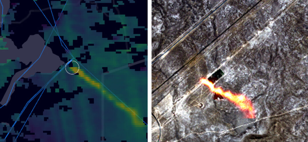
For the first time, scientists, using satellite data from the Copernicus Sentinel missions, are now able to detect individual methane plumes leaking from natural gas pipelines around the globe.
Nabídka odborné stáže nebo praxe
4.3.2021 9:20 Katedra geoinformatiky UP OlomoucSpolečnost SolverTech nabízí našim studentům možnost praxe nebo odborné stáže s potenciálem pro další spolupráci. Víc informací naleznete v příloze: Výběrové řízení SolverTech – odborná stáže
The post Nabídka odborné stáže nebo praxe appeared first on Katedra geoinformatiky.
Vedoucí oddělení digitální kartografie III
4.3.2021 8:58 Zeměměřický úřad Zeměměřický úřadvypisuje výběrové řízení na místo
Vedoucí oddělení digitální kartografie III
Vedoucí oddělení digitální kartografie III
4.3.2021 8:58 ČÚZK - předpisy a opatření Zeměměřický úřadvypisuje výběrové řízení na místo
Vedoucí oddělení digitální kartografie III
Vedoucí oddělení digitální kartografie III
4.3.2021 8:58 ČÚZK /Urady/Zememericky-urad/Uredni-deska/Oznameni-a-jina-uredni-sdeleni/Volna-mista/Vedouci-oddeleni-digitalni-kartografie-IIIVedoucí oddělení digitální kartografie III
4.3.2021 8:58 ČÚZK - volná místa Zeměměřický úřad vypisuje výběrové řízení na místo Vedoucí oddělení digitální kartografie IIIVšechny družice kolem Země. Podívejte se, která právě letí nad vámi
4.3.2021 8:04 GeoBusinessAplikace Satellite Map zobrazuje v reálném čase aktuální pozici všech člověkem vytvořených objektů, obíhajících kolem Země. Družic je přes devatenáct tisíc. Aplikace navrhl a vytvořil Richie Carmichael v redlandské Applications Prototype Lab firmy Esri. Pro kódování použil následující technologie: ArcGIS API for JavaScript (version 4) od Esri Bootstrap od Twitteru Bootstrap Slider, který vytvořil Kyle J. […]
The post Všechny družice kolem Země. Podívejte se, která právě letí nad vámi appeared first on GeoBusiness.
GeoInfoStrategie seminář (pozvánka)
4.3.2021 8:03 GISportal.cz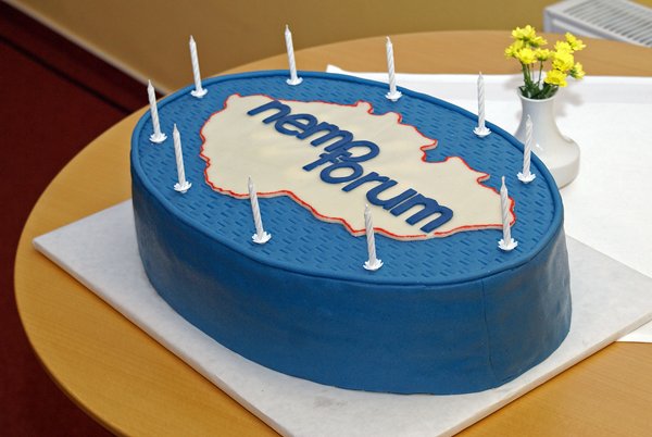
“GeoInfoStrategie – co se podařilo a co ne”, je seminář, který pořádá sdružení Nemoforum ve spolupráci s dalšími partnery ve středu 24. března 2021 (garantem akce je RNDr Eva Kubátová, MV). Program semináře a odkaz na registrační formulář najdete na webu Nemofora na adrese www.cuzk.cz/nemoforum. Uzávěrka přihlašování je 22.března. Seminář proběhne videokonferečně, s technickou podporou ČÚZK. […]
The post GeoInfoStrategie seminář (pozvánka) appeared first on GISportal.cz.
20210304 - změna úředních hodin od 8.3.2021
4.3.2021 7:25 ČÚZK /Urady/Katastralni-urady/Katastralni-urady/Katastralni-urad-pro-Ustecky-kraj/Katastralni-pracoviste/KP-Louny/O-uradu/Aktuality/2021-zmena-urednich-hodin-od-8-3-202120210304 - změna úředních hodin od 8.3.2021
4.3.2021 7:25 ČÚZK - předpisy a opatření Katastrální úřad pro Ústecký kraj - Katastrální pracoviště Louny zveřejnil novou aktualitu:S účinností od 8.3.2021 je provedena změna Úředních hodin na Katastrálním pracovišti Louny Katastrálního úřadu pro Ústecký kraj.
Úřední hodiny jsou nově pro všechny agendy:
Pondělí, Středa : 8:00 - 17:00
Podání je též možné vhodit do sběrného boxu, který je přístupný ve vchodu do budovy v době
Pondělí, Středa : 8:00 - 17:00,
Úterý, Čtvrtek : 8:00 - 14:00Pátek : 8:00 - 12:00
Výběrové řízení
4.3.2021 7:22 ČÚZK /Urady/Katastralni-urady/Katastralni-urady/Katastralni-urad-pro-Plzensky-kraj/O-uradu/Aktuality/Vyberove-rizeni-(6)Výběrové řízení
4.3.2021 7:22 ČÚZK - předpisy a opatření Katastrální úřad pro Plzeňský kraj - Katastrální pracoviště Plzeň-jih zveřejnil novou aktualitu: Ředitelka Katastrálního úřadu pro Plzeňský kraj vyhlašuje výběrové řízení na služební místo vrchní referent/rada – vedení katastrální mapy VKM0901, oddělení aktualizace a dokumentace KN, Katastrální úřad pro Plzeňský kraj, Katastrální pracoviště Plzeň-jih.Vrchní referent/rada – vedení katastrální mapy
4.3.2021 7:17 ČÚZK - volná místa Katastrální úřad pro Plzeňský kraj Katastrální pracoviště Plzeň-jih vypisuje výběrové řízení na místo Vrchní referent/rada – vedení katastrální mapyVrchní referent/rada – vedení katastrální mapy
4.3.2021 7:17 ČÚZK /Urady/Katastralni-urady/Katastralni-urady/Katastralni-urad-pro-Plzensky-kraj/Uredni-deska/Oznameni-a-jina-uredni-sdeleni/Volna-mista/DMS/Vrchni-referent-rada-–-vedeni-katastralni-mapyVrchní referent/rada – vedení katastrální mapy
4.3.2021 7:17 ČÚZK - předpisy a opatření Katastrální úřad pro Plzeňský kraj Katastrální pracoviště Plzeň-jihvypisuje výběrové řízení na místo
Vrchní referent/rada – vedení katastrální mapy
Ouster Signs Over 20 Strategic Customer Agreements in 8 Months
4.3.2021 3:13 GISCafe.com Webcasts-Webinars Ouster’s multi-year contracts represent a potential for over $325M in revenue opportunity through 2025SAN FRANCISCO — (BUSINESS WIRE) …
KPÚ pro Jihomoravský kraj zrealizoval projekty za více než 100 miliónů
4.3.2021 0:00 Státní pozemkový úřad Praha, 4. března 2021 – V roce 2020 Státní pozemkový úřad (SPÚ) v Jihomoravském kraji zrealizoval nebo započal realizace pozemkových úprav za více než 100 miliónů Kč. SPÚ je v Jihomoravském kraji zastoupen svým Krajským pozemkovým úřadem se sídlem v Brně a 6 pobočkami v Blansku, Brně, Břeclavi, Hodoníně, Vyškově a Znojmě.exactEarth to provide Advanced AIS services for MDA's Dark Vessel Detection Program
3.3.2021 20:37 GISCafe.com Webcasts-Webinars CAMBRIDGE, ON, March 3, 2021 /CNW/ - exactEarth Ltd. ("the Company") (TSX: XCT), announces that it has signed an agreement with MDA to provide …Decisive Point Announces Investment in Asylon to Accelerate Autonomous Systems for Security and Defense
3.3.2021 17:34 GISCafe.com Webcasts-Webinars NEW YORK, March 3, 2021 — (PRNewswire) — Decisive Point is pleased to announce its investment in Asylon, Inc., a manufacturer of …Velodyne Lidar Announces Free Virtual Summit, Disruptive Women Powering Our Autonomous Future
3.3.2021 16:18 GISCafe.com Webcasts-Webinars On March 25, Top Execs and Engineers Discuss the Future of AV Technology and the Role of Women in the AV IndustrySAN JOSE, Calif. — (BUSINESS …
Woolpert Acquires Texas-Based CivilTech Engineering Inc. to Expand Water, Transportation Initiatives in Texas
3.3.2021 16:18 GISCafe.com Webcasts-Webinars The firms will work together to address aging infrastructure concerns throughout Texas and across the U.S., supporting more resilient, capable and …Location IQ Partners with Orbital Insight to Help Retailers Understand Shifting Demand
3.3.2021 16:18 GISCafe.com Webcasts-Webinars Australian economics advisory firm will enable clients to monitor activities and patterns using Orbital Insight's geospatial analyticsPALO ALTO, …
20210303 - Upozornění uživatelům VFR
3.3.2021 15:14 ČÚZK - předpisy a opatření Upozornění uživatelům VFR: Současné stavové (měsíční) soubory VFR za únor 2021 byly vygenerovány o dva dny později, mají tedy označení 20210302_*, ale obsahově jsou se stavem dat k 28. 2. 2021. Soubory jsou dostupné i pod názvem 20210228_*.Zveřejněno: 3. 3. 2021
20210303 - Upozornění uživatelům VFR
3.3.2021 15:14 ČÚZK - předpisy a opatření Upozornění uživatelům VFR: Současné stavové (měsíční) soubory VFR za únor 2021 byly vygenerovány o dva dny později, mají tedy označení 20210302_*, ale obsahově jsou se stavem dat k 28. 2. 2021.Zveřejněno: 3. 3. 2021
20210303 - Upozornění uživatelům VFR
3.3.2021 15:14 ČÚZK /Uvod/Produkty-a-sluzby/RUIAN/2-Poskytovani-udaju-RUIAN-ISUI-VDP/Vymenny-format-RUIAN/Archiv-novinek-VFR/20210303-Upozorneni-uzivatelum-VFROznámení o omezeném provozu
3.3.2021 12:49 ČÚZK - předpisy a opatření Katastrální úřad pro Vysočinu - Katastrální pracoviště Pelhřimov zveřejnil novou aktualitu: Oznámení o omezeném provozu Katastrálního pracoviště Pelhřimov od 1.března 2021 po dobu nouzového stavu.Oznámení o omezeném provozu
3.3.2021 12:49 ČÚZK /Urady/Katastralni-urady/Katastralni-urady/Katastralni-urad-pro-Vysocinu/Katastralni-pracoviste/KP-Pelhrimov/O-uradu/Aktuality/Oznameni-o-omezenem-provozuOznámení o omezeném provozu
3.3.2021 12:49 ČÚZK - předpisy a opatření Katastrální úřad pro Vysočinu - Katastrální pracoviště Pelhřimovzveřejnil novou aktualitu: Oznámení o omezeném provozu Katastrálního pracoviště Pelhřimov od 1.března 2021 po dobu nouzového stavu.
Pandemie odkryla závažné nedostatky státu v práci s daty. Open Data Expo představí příklady efektivní práce s daty
3.3.2021 12:33 GeoBusinessRok po tom, co se v České republice objevil nový typ koronaviru, stále neexistuje vládní reflexe práce s daty. A to ani ve chvíli, kdy na informacích a jejich analýze závisí stav veřejného zdraví. Šestý ročník největšího veletrhu otevřených dat s názvem [PANDEMIC] Open Data Expo nabídne zhodnocení učiněných vládních opatření v kontextu využívání a […]
The post Pandemie odkryla závažné nedostatky státu v práci s daty. Open Data Expo představí příklady efektivní práce s daty appeared first on GeoBusiness.
Výroční zpráva za rok 2020
3.3.2021 12:10 ČÚZK - předpisy a opatření Katastrální úřad pro Moravskoslezský krajvydává výroční zprávu úřadu za rok
2020
Výroční zpráva za rok 2020
3.3.2021 12:10 ČÚZK /Urady/Katastralni-urady/Katastralni-urady/Katastralni-urad-pro-Moravskoslezsky-kraj/Vyrocni-zpravy/Vyrocni-zprava-za-rok-2020Geoinformace ve veřejné správě 2021 (pozvánka)
3.3.2021 9:41 GISportal.cz
Česká asociace pro geoinformace (CAGI) zve na tradiční konferenci Geoinformace ve veřejné správě 2021, která se uskuteční 3.–4. května 2021 videokonferenční formou. Hlavními tématy letošního ročníku konference Geoinformace ve veřejné správě 2021 jsou: DMVS, DTM, Digitalizace stavebního řízení GeoInfoStrategie Dopady Koncepce zavádění BIM na NIPI v ČR Významné projekty veřejné správy, INSPIRE Smart City […]
The post Geoinformace ve veřejné správě 2021 (pozvánka) appeared first on GISportal.cz.
MyGalileoSolution & MyGalileoDrone: Galileo means business for SMEs and start-ups!
3.3.2021 9:23 European GNSS Agency
The European GNSS Agency (GSA) is excited to announce the winners in this year’s MyGalileoSolution & MyGalileoDrone competitions. After a lively debate, the jury has selected the winning teams in both competitions based not only on their innovative use of key Galileo differentiators, but also on their market-oriented approach and potential for wide uptake. The winning teams were announced during Entrepreneurship Day, hosted by the GSA on 2 March. And so, without further ado, the winners are…
In the MyGalileoDrone competition, the first prize went to the team Abzero (Italy), for Nautilus – a unique tracking solution for the autonomous delivery of medical goods. Second prize was awarded to Spectralight (Poland) for SpectraDrone, a greener alternative to classical fireworks. ThunderFly (Czech Republic) received third prize for TF-ATMON – a system for performing in-situ atmospheric measurements, while fourth prize went to Raytrack (Spain) for 5GBeamCheck, which uses a UAV to perform 5G antenna tests. The winning team receives EUR 100,000, with EUR 60,000 going to the team in second place, EUR 40,000 for third place, and EUR 30,000 to the fourth.
MyGalileoSolution results
In the MyGalileoSolution competition, the first place in Track 1 (from idea to prototype) went to VisionAnchor (Slovenia) the world's first video anchor monitoring system for boats, with second prize going to BitPet (Norway), an Augmented Reality mobile game where each player takes care of a digital pet. Third prize went to BeeLive (Greece), a beekeeper's decision-making and social networking tool based on GNSS-enabled devices.
Read this: Galileo enabling infrastructure development in harsh environments
Meanwhile, in Track 2 (from prototype to product), the top three teams were 10Lines (Estonia), an autonomous parking lot marking solution in first place, followed by V-Labs (Switzerland), an Augmented Reality solution for visualising, measuring and modifying geospatial data with centimetre accuracy in second, and Lympik Oculus (Austria), a sport analysis application in third. MyGalileoSolution is the biggest competition ever organised by the GSA, with a prize pool of almost EUR 1.5 million shared by 50 teams, including the six finalists, with awards ranging from EUR 15,000 to EUR 60,000.
Fostering Galileo’s uptake
At the Entrepreneurship Day, the top contestants from both competitions presented their applications and pitched their ideas after which the winning teams were announced and the prizes awarded.
“This year’s competition was exceptional and I congratulate all the winners on their victory,” said GSA Executive Director Rodrigo da Costa. “The MyGalileoSolution and MyGalileoDrone competitions play an important role in fostering the uptake of Galileo across a wide range of market segments. A key role of the GSA, and of EUSPA in the future, is to increase the competitiveness of the EU downstream industry by supporting innovators, SMEs and start-ups. These two competitions help us to do exactly that,” he said.
About MyGalileoDrone & MyGalileoSolution
MyGalileoSolution and MyGalileoDrone are the continuation of the successful MyGalileoApp competition. The competitions, which ran over 6 months, included multiple rounds of reviews with GSA, market and technology experts, and the teams received mentoring on a variety of subjects. More than 600 applications were received to both competitions and 80 start-ups were supported by the GSA to realize their dream.
And this: Galileo delivers accuracy; drones deliver solutions
The teams came from various locations in Europe and represent academia and industry alike. They include start-ups and SMEs from a broad spectrum of market segments. The total prize pool of the competitions is EUR 1.7 million, including the grand prizes for the top teams and smaller awards for qualifying solutions. Contestants were evaluated based on criteria such as innovation, Galileo relevance, market potential and feasibility of implementing the ideas.
About Entrepreneurship Day
Entrepreneurship Day, hosted by the GSA on 2 March, is one of the first events launched under the umbrella of the CASSINI initiative. The half-day event is one of many upcoming activities to be hosted by the GSA, aimed at supporting entrepreneurship by providing opportunities for entrepreneurs and innovators.
The event aimed to promote EGNSS-based creative ideas and lucrative business opportunities, to raise awareness of the role of downstream space in achieving the EU’s common goals and priorities, and to provide a networking platform for all interested parties.
Media note: This feature can be republished without charge provided the European GNSS Agency (GSA) is acknowledged as the source at the top or the bottom of the story. You must request permission before you use any of the photographs on the site. If you republish, we would be grateful if you could link back to the GSA website (http://www.gsa.europa.eu).
Space in response to COVID-19
3.3.2021 9:00 ESA Observing the Earth
Do you have fresh ideas on how Earth observation data can contribute to monitoring the effects brought on by the COVID-19 pandemic? If so, ESA and the European Commission have launched a new series of monthly challenges asking for innovative solutions on how satellite data can be used to help better understand the effects of the coronavirus on society, economy and the environment.
Webinář 9: Využití dat dálkového průzkumu Země v zemědělství s ohledem na využití časových řad z dat Copernicus Sentinel-1 a Sentinel-2 (pozvánka)
3.3.2021 8:58 GISportal.cz
Webinář Využití dat dálkového průzkumu Země v zemědělství s ohledem na využití časových řad z dat Copernicus Sentinel-1 a Sentinel-2 – 9.3.2021 13:00 Cílem webináře je seznámit publikum s nejnovějšími výsledky našeho vývoje v oblasti DPZ pro zemědělství a to především ve zpracování časových řad z dat evropského vesmírného programu Copernicus. Ve své práci se zaměřujeme nejen […]
The post Webinář 9: Využití dat dálkového průzkumu Země v zemědělství s ohledem na využití časových řad z dat Copernicus Sentinel-1 a Sentinel-2 (pozvánka) appeared first on GISportal.cz.
Hybridní 30. mezinárodní kartografická konference se koná v Itálii. Přihlaste včas svůj referát
3.3.2021 8:09 GeoBusinessV polovině prosince, konkrétně od 14. do 18. prosince 2021, se má ve Florencii (Itálie) uskutečnit v pořadí již třicátá mezinárodní kartografická konference (International Cartographic Conference 2021), pořádaná jednou za dva roky Mezinárodní kartografickou společností ICA. Součástí konference bude také mezinárodní kartografická výstava a výstava vítězných dětských kreseb, zapojených do soutěže Dětská mapa světa Barbary […]
The post Hybridní 30. mezinárodní kartografická konference se koná v Itálii. Přihlaste včas svůj referát appeared first on GeoBusiness.
Výtvarná soutěž pro děti: Mapa mého budoucího světa
3.3.2021 8:04 GeoBusinessČeská kartografická společnost ve spolupráci s katedrou geografie Technické univerzity v Liberci organizuje národní kolo mezinárodní umělecko-kartografické soutěže Dětská mapa světa Barbary Petchenik. Do předchozího ročníku soutěže v roce 2019 se zapojilo více než sedmdesát škol z celé České republiky. Téma letošního ročníku soutěže je Mapa mého budoucího světa (A Map of My Future World). […]
The post Výtvarná soutěž pro děti: Mapa mého budoucího světa appeared first on GeoBusiness.
NV5 Announces Record Fourth Quarter and Full Year 2020 Results; Exceeds Analysts' Expectations
3.3.2021 1:39 GISCafe.com Webcasts-Webinars HOLLYWOOD, Fla., March 02, 2021 (GLOBE NEWSWIRE) -- NV5 Global, Inc. (Nasdaq: NVEE) (“NV5” or the “Company”), a provider of compliance, …SPÚ odvedl v roce 2020 do státního rozpočtu více jak 296 miliónů za pronájmy
3.3.2021 0:00 Státní pozemkový úřad Praha, 3. března 2021 – Státní pozemkový úřad (SPÚ) v loňském roce odvedl do státního rozpočtu více jak 296 miliónů za pronájmy. Právě touto nemalou částkou přispěl Odbor správy majetku státu, mezi jehož agendy patří nejen nájem a pacht, ale i narovnání majetkových vztahů nebo rozhodování o zařazení či vyřazení pozemků do nebo z rezervy pro rozvojové programy státu schválené vládou.USGIF Board of Directors Appoints New Chair
2.3.2021 22:32 GISCafe.com Webcasts-Webinars USGIF elects Robert Cardillo as the new chair of the board
Herndon, VA (March 2, 2021)— The United States Geospatial Intelligence …
INT's INTViewer 2021 Release Extends Functionality for Geoscience Data QA/QC from Anywhere
2.3.2021 20:18 GISCafe.com Webcasts-Webinars New features expand support for well data analysis, mapping, import/export georeferenced images, more flexible licensing, and more.HOUSTON, Mar. 2, …
Otevřené jaro: Družicová data Copernicus pro zemědělství (a pojišťovnictví, potravinářství a veřejnou správu)
2.3.2021 18:04 GeoBusinessV rámci Otevřeného jara se koná webinář o používání družicových dat z Copernicus Sentinel-1 a Sentinel-2. Plan4all pořádá 9. března od 13 hodin webinář (registrace zdarma), během něhož seznámí s aktuálními výsledky vývoje v oblasti DPZ pro zemědělství. Autoři se zaměří na zpracování časových řad z dat evropského vesmírného programu Copernicus. Konkrétně jde o propojení […]
The post Otevřené jaro: Družicová data Copernicus pro zemědělství (a pojišťovnictví, potravinářství a veřejnou správu) appeared first on GeoBusiness.
Otevřené jaro: Družicová data Copernicus pro zemědělství (a pojišťovnictví, potravinářství a veřejnou správu)
2.3.2021 18:04 GeoBusinessV rámci Otevřeného jara se koná webinář o používání družicových dat z Copernicus Sentinel-1 a Sentinel-. Plan4all pořádá 9. března od 13 hodin webinář (registrace zdarma), během něhož seznámí s aktuálními výsledky vývoje v oblasti DPZ pro zemědělství. Autoři se zaměří na zpracování časových řad z dat evropského vesmírného programu Copernicus. Konkrétně jde o propojení […]
The post Otevřené jaro: Družicová data Copernicus pro zemědělství (a pojišťovnictví, potravinářství a veřejnou správu) appeared first on GeoBusiness.
Geospatial Technology Company AGERpoint Welcomes New CEO
2.3.2021 17:23 GISCafe.com Webcasts-Webinars NEW SMYRNA BEACH, Fla. — (BUSINESS WIRE) — March 2, 2021 — AGERpoint, Inc. (“AGERpoint”), a leader in geospatial …Sanborn Partners with U.S. Geological Survey on Arizona Project
2.3.2021 17:21 GISCafe.com Webcasts-Webinars The Sanborn Map Company, Inc. (Sanborn) builds public-private partnership to support U.S. Geological Survey (USGS) 3D Elevation Program (3DEP) …Quanergy and Shanghai Rays Accelerate Shandong Port Group’s Terminal Automation with 3D LiDAR Technology
2.3.2021 17:21 GISCafe.com Webcasts-Webinars Reduced more than 90% of work-related accidents in the bulk material operationIncreased productivity by 20% compared to manual operation
The 3D …
In High Gear: Annual US Home Price Appreciation Reaches Double Digits in January, CoreLogic Reports
2.3.2021 17:21 GISCafe.com Webcasts-Webinars CoreLogic Home Price Index reached highest annual gain since 2013 in January at 10%Affordability and low supply remain top challenges for …
Red Fox ID and Cepton Enable Barrier-Free, High-Speed Tolling Worldwide With High Performance Lidar Based Solutions
2.3.2021 17:21 GISCafe.com Webcasts-Webinars First commercial deployment on a major US highway turnpike used by tens of millions of vehicles every yearSAN JOSE, Calif. — (BUSINESS WIRE) …
CEMEX Transforms Stockpile Management with Kespry AI-powered Aerial Intelligence Platform
2.3.2021 17:21 GISCafe.com Webcasts-Webinars Global building materials company has more efficient and safer jobsite operations than ever beforeMENLO PARK, Calif., March 2, 2021 — …
Concept3D Offers Virtual Tour and Mapping Software to Hospitality and Tourism Industry at No Cost
2.3.2021 17:21 GISCafe.com Webcasts-Webinars Leverage Concept3D's Powerful 360° Virtual Tour or Interactive Map Platform to Support Marketing and Generate InterestDENVER, March 2, 2021 — …
20210302_Úprava úředních hodin
2.3.2021 17:17 ČÚZK - předpisy a opatření Katastrální úřad pro Středočeský kraj - Katastrální pracoviště Příbram zveřejnil novou aktualitu: Úprava úředních hodin Úprava úředních hodinZ důvodu epidemiologické situace na pracovišti budou ve dnech 3. 3. 2021 - 19.03.2021 omezeny úřední hodiny na dobu 08:00 - 13:00 hod.
20210302_Úprava úředních hodin
2.3.2021 17:17 ČÚZK - předpisy a opatření Katastrální úřad pro Středočeský kraj - Katastrální pracoviště Příbram zveřejnil novou aktualitu: Úprava úředních hodin Úprava úředních hodinZ důvodu epidemiologické situace na pracovišti budou ve dnech 3. 3. 2021 - 10.03.2021 omezeny úřední hodiny na dobu 08:00 - 13:00 hod.
20210302_Úprava úředních hodin
2.3.2021 17:17 ČÚZK /Urady/Katastralni-urady/Katastralni-urady/Katastralni-urad-pro-Stredocesky-kraj/Katastralni-pracoviste/KP-Pribram/O-uradu/Aktuality/20210302_Uprava-urednich-hodinByla publikována nová sestaven
2.3.2021 14:48 GEUSware Byla publikována nová sestavení GEUS 25.0.2.302 a Geometr 18.0.12. Tato sestavení řeší nefunkčnost Nahlížení do KN.Oznámení o vyhlášení výběrového řízení na služební místo rada/odborný rada
2.3.2021 13:59 ČÚZK /Urady/Katastralni-urady/Katastralni-urady/Katastralni-urad-pro-Vysocinu/O-uradu/Aktuality/Oznameni-o-vyhlaseni-vyberoveho-rizeni-na-sluzebniOznámení o vyhlášení výběrového řízení na služební místo rada/odborný rada
2.3.2021 13:59 ČÚZK - předpisy a opatření Katastrální úřad pro Vysočinu zveřejnil novou aktualitu: Oznámení o vyhlášení výběrového řízení na služební místo rada/odborný rada v oddělení aktualizace KNKatastrálního pracoviště Žďár nad Sázavou.
V Třebíči GIS pomáhá se správou blokového čištění
2.3.2021 13:26 T-MAPYThe post V Třebíči GIS pomáhá se správou blokového čištění appeared first on T-MAPY spol. s r.o..
oznámení-rada - odborný rada - oddělení aktualizace KN
2.3.2021 12:56 ČÚZK - předpisy a opatření Katastrální úřad pro Vysočinu Katastrální pracoviště Žďár nad Sázavouvypisuje výběrové řízení na místo
oznámení-rada - odborný rada - oddělení aktualizace KN
oznámení-rada - odborný rada - oddělení aktualizace KN
2.3.2021 12:56 ČÚZK /Urady/Katastralni-urady/Katastralni-urady/Katastralni-urad-pro-Vysocinu/Uredni-deska/Oznameni-a-jina-uredni-sdeleni/Volna-mista/DMS/oznameni-rada-odborny-rada-oddeleni-aktualizacoznámení-rada - odborný rada - oddělení aktualizace KN
2.3.2021 12:56 ČÚZK - volná místa Katastrální úřad pro Vysočinu Katastrální pracoviště Žďár nad Sázavou vypisuje výběrové řízení na místo oznámení-rada - odborný rada - oddělení aktualizace KNGiant iceberg breaks off Brunt Ice Shelf in Antarctica
2.3.2021 10:00 ESA Observing the Earth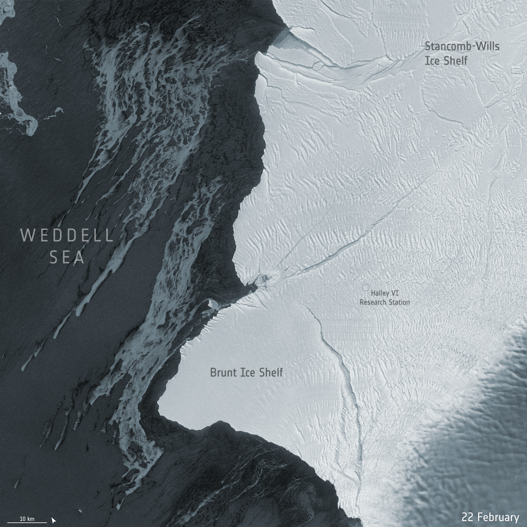 Image:
New Copernicus Sentinel-1 radar images show a giant iceberg breaking off from the northern section of Antarctica’s Brunt Ice Shelf
Image:
New Copernicus Sentinel-1 radar images show a giant iceberg breaking off from the northern section of Antarctica’s Brunt Ice Shelf
Giant iceberg breaks off Brunt Ice Shelf in Antarctica
2.3.2021 10:00 ESA Observing the Earth Image:
New Copernicus Sentinel-1 radar images show a giant iceberg breaking off from the northern section of Antarctica’s Brunt Ice Shelf
Image:
New Copernicus Sentinel-1 radar images show a giant iceberg breaking off from the northern section of Antarctica’s Brunt Ice Shelf
odborný referent v oddělení právních vztahů k nemovitostem Katastrálního pracoviště Pardubice
2.3.2021 9:46 ČÚZK /Urady/Katastralni-urady/Katastralni-urady/Katastralni-urad-pro-Pardubicky-kraj/Uredni-deska/Oznameni-a-jina-uredni-sdeleni/Volna-mista/odborny-referent-v-oddeleni-pravnich-vztahu-k-nemoodborný referent v oddělení právních vztahů k nemovitostem Katastrálního pracoviště Pardubice
2.3.2021 9:46 ČÚZK - předpisy a opatření Katastrální úřad pro Pardubický kraj - Katastrální pracoviště Pardubicevypisuje výběrové řízení na místo
odborný referent v oddělení právních vztahů k nemovitostem Katastrálního pracoviště Pardubice
odborný referent v oddělení právních vztahů k nemovitostem Katastrálního pracoviště Pardubice
2.3.2021 9:46 ČÚZK - volná místa Katastrální úřad pro Pardubický kraj - Katastrální pracoviště Pardubice vypisuje výběrové řízení na místo odborný referent v oddělení právních vztahů k nemovitostem Katastrálního pracoviště PardubiceCEDA e-slaví 20 let
2.3.2021 9:35 CEDA Maps a.s. Praha, 2. března 2021 - Právě v této době oslavujeme 20 let, co společnost CEDA Maps a.s., tehdy ještě jako Central European data Agency, a.s. začala podnikat. Za normální situace bychom pozvali naše partnery, kolegy a další příznivce a oslavili bychom toto kulaté výročí společně. Bohužel to nyní není možné, a tak mi dovolte alespoň dálku symbolicky připít CEDA na zdraví a poděkovat všem, kteří se přičinili o to, že CEDA vyrostla a dospěla v silnou, úspěšnou společnost.Vrchní referent/rada v personálním oddělení v Kanceláři ředitele katastrálního úřadu
2.3.2021 9:22 ČÚZK /Urady/Katastralni-urady/Katastralni-urady/Katastralni-urad-pro-Jihomoravsky-kraj/Volna-mista/DMS/Vrchni-referent-rada-v-personalnim-oddeleni-v-(1)Vrchní referent/rada v personálním oddělení v Kanceláři ředitele katastrálního úřadu
2.3.2021 9:22 ČÚZK - volná místa Katastrální úřad pro Jihomoravský kraj kancelář úřadu vypisuje výběrové řízení na místo Vrchní referent/rada v personálním oddělení v Kanceláři ředitele katastrálního úřaduVrchní referent/rada v personálním oddělení v Kanceláři ředitele katastrálního úřadu
2.3.2021 9:22 ČÚZK - předpisy a opatření Katastrální úřad pro Jihomoravský kraj kancelář úřaduvypisuje výběrové řízení na místo
Vrchní referent/rada v personálním oddělení v Kanceláři ředitele katastrálního úřadu
Nefunkčnost Geoportálu ÚAP
2.3.2021 8:30 Ústecký kraj Z technických důvodů nejsou v současné době prováděny aktualizace dat. Objednávkový systém dat ÚAP funguje, nicméně objednávky jsou vyřizovány mimo systém, manuálně.odborný referent v oddělení dokumentace katastru nemovitostí
2.3.2021 6:45 ČÚZK /Urady/Katastralni-urady/Katastralni-urady/Katastralni-urad-pro-Liberecky-kraj/Uredni-deska/Oznameni-a-jina-uredni-sdeleni/Volna-mista/odborny-referent-v-oddeleni-dokumentace-katast-(1)odborný referent v oddělení dokumentace katastru nemovitostí
2.3.2021 6:45 ČÚZK - volná místa Katastrální úřad pro Liberecký kraj - Katastrální pracoviště Liberec vypisuje výběrové řízení na místo odborný referent v oddělení dokumentace katastru nemovitostíodborný referent v oddělení dokumentace katastru nemovitostí
2.3.2021 6:45 ČÚZK - předpisy a opatření Katastrální úřad pro Liberecký kraj - Katastrální pracoviště Liberecvypisuje výběrové řízení na místo
odborný referent v oddělení dokumentace katastru nemovitostí
Online data z dopravy a jejich využití
2.3.2021 6:23 GeoBusinessVěděli jste, že díky analýze dat v reálném čase je možné sledovat aktuální dění v dopravě, obsazenost parkovacích míst nebo dobíjecích stanic pro elektromobily? Podívejte se na prezentaci firmy CEDA Maps o efektivním využití online dat v dopravě. Přednáška byla součástí videokonference GIS Esri v ČR na podzim 2020. Za firmu CEDA Maps přednášeli Radovan […]
The post Online data z dopravy a jejich využití appeared first on GeoBusiness.
GIVS 2021. Přihlaste se na konferenci Geoinformace ve veřejné správě
1.3.2021 19:28 GeoBusinessČeská asociace pro geoinformace pořádá počátkem května konferenci Geoinformace ve veřejné správě. Letos, podobně jako v předchozím roce, bude konference z důvodu přetrvávající situace s covid-19 v online podobě jako videokonference. 14. ročník konference Geoinformace ve veřejné správě 2021 se uskuteční v termínu 3. až 4. května. Témata konference GIVS 2021 DMVS, DTM, Digitalizace stavebního […]
The post GIVS 2021. Přihlaste se na konferenci Geoinformace ve veřejné správě appeared first on GeoBusiness.
CoreLogic Confirms Receipt of Revised Acquisition Proposal from CoStar
1.3.2021 19:11 GISCafe.com Webcasts-Webinars IRVINE, Calif. — (BUSINESS WIRE) — March 1, 2021 —CoreLogic® (NYSE: CLGX), a leading global property data and analytics-driven …
dataPlor launches LATAM regional SMB dataset with over five million verified records
1.3.2021 19:11 GISCafe.com Webcasts-Webinars dataPlor, a leading provider of emerging markets business and point-of-interest (POI) data today announced the launch of its licensable Latin …ST Engineering Geo-Insights Partners with BlackSky to Offer Expanded Satellite Imaging and Analytics Insights Portfolio for Customers in Southeast Asia
1.3.2021 16:53 GISCafe.com Webcasts-Webinars SINGAPORE & HERNDON, Va. — (BUSINESS WIRE) — February 28, 2021 —ST Engineering’s earth observation and geospatial analysis …
CoreLogic Reports Record Full-Year and Fourth Quarter 2020 Revenue, Operating Income, Profit Margins and Cash Flow
1.3.2021 16:53 GISCafe.com Webcasts-Webinars Fueled by Double-Digit Revenue Growth Driven by Housing Market Activity and Share Gains, Operating Leverage and Cost ProductivityReturned $595 …
U.S. Autonomous Drone Maker Skydio Announces $170 Million In Series D Funding Led by Andreessen Horowitz’s Growth Fund
1.3.2021 16:53 GISCafe.com Webcasts-Webinars REDWOOD CITY, Calif. — (BUSINESS WIRE) — March 1, 2021 —Skydio, the leading U.S. drone manufacturer and world leader in …
Workhorse Group Reports Fourth Quarter and Full Year 2020 Results
1.3.2021 16:53 GISCafe.com Webcasts-Webinars CINCINNATI, March 01, 2021 (GLOBE NEWSWIRE) -- Workhorse Group Inc. (Nasdaq: WKHS) (“Workhorse” or “the Company”), an American technology …Změna úředních hodin
1.3.2021 15:25 ČÚZK - předpisy a opatření Katastrální úřad pro Středočeský kraj - Katastrální pracoviště Slaný zveřejnil novou aktualitu: Změna úředních hodin Od 3.3.2021 bude na KP Slaný změna úředních hodin pro veřejnost:Pondělí 8 - 17 hod.
Středa 8 - 17 hod.
Ostatní dny bude pracoviště pro veřejnost uzavřené, v tyto dny je možné podání hodit do sběrného boxu vedle vchodových dveří.
Změna úředních hodin od 1.3.2021
1.3.2021 14:32 ČÚZK /Urady/Katastralni-urady/Katastralni-urady/Katastralni-urad-pro-Stredocesky-kraj/Katastralni-pracoviste/KP-Rakovnik/O-uradu/Aktuality/Zmena-urednich-hodin-od-1-3-2021Změna úředních hodin od 1.3.2021
1.3.2021 14:32 ČÚZK - předpisy a opatření Katastrální úřad pro Středočeský kraj - Katastrální pracoviště Rakovník zveřejnil novou aktualitu: Od 1.3.2021 dochází ke změně úředních hodin a to:PONDĚLÍ 8-17 hodin a
STŘEDA 8-17 hodin
20210301_Informace
1.3.2021 13:58 ČÚZK - předpisy a opatření Zeměměřický úřad zveřejnil novou aktualitu: V souladu s Usnesením vlády ČR č. 199 ze dne 26. února je uzavřena pro návštěvy veřejnosti badatelna Ústředního archivu zeměměřictví a katastru a prodejna map. Je nutné upřednostnit jiné způsoby komunikace, např. e-mail, datová zpráva, popř. telefon. V případě objednání tištěných produktů využijte možnosti zaslání poštou, nevolte prosím osobní odběr v prodejně map. Služby Geoportálu ČÚZK včetně CZEPOS a dalších geodetických aplikací pro potřeby zeměměřičů jsou provozovány bez omezení.20210301_Informace
1.3.2021 13:58 Zeměměřický úřad Zeměměřický úřad zveřejnil novou aktualitu: V souladu s Usnesením vlády ČR č. 199 ze dne 26. února je uzavřena pro návštěvy veřejnosti badatelna Ústředního archivu zeměměřictví a katastru a prodejna map. Je nutné upřednostnit jiné způsoby komunikace, např. e-mail, datová zpráva, popř. telefon. V případě objednání tištěných produktů využijte možnosti zaslání poštou, nevolte prosím osobní odběr v prodejně map. Služby Geoportálu ČÚZK včetně CZEPOS a dalších geodetických aplikací pro potřeby zeměměřičů jsou provozovány bez omezení.20210301_Informace
1.3.2021 13:58 Zeměměřický úřad Zeměměřický úřadzveřejnil novou aktualitu: V souladu s Usnesením vlády ČR č. 199 ze dne 26. února je uzavřena pro návštěvy veřejnosti badatelna Ústředního archivu zeměměřictví a katastru a prodejna map. Je nutné upřednostnit jiné způsoby komunikace, např. e-mail, datová zpráva, popř. telefon. V případě objednání tištěných produktů využijte možnosti zaslání poštou, nevolte prosím osobní odběr v prodejně map. Služby Geoportálu ČÚZK včetně CZEPOS a dalších geodetických aplikací pro potřeby zeměměřičů jsou provozovány bez omezení.
20210301_Informace
1.3.2021 13:58 ČÚZK - předpisy a opatření Zeměměřický úřadzveřejnil novou aktualitu: V souladu s Usnesením vlády ČR č. 199 ze dne 26. února je uzavřena pro návštěvy veřejnosti badatelna Ústředního archivu zeměměřictví a katastru a prodejna map. Je nutné upřednostnit jiné způsoby komunikace, např. e-mail, datová zpráva, popř. telefon. V případě objednání tištěných produktů využijte možnosti zaslání poštou, nevolte prosím osobní odběr v prodejně map. Služby Geoportálu ČÚZK včetně CZEPOS a dalších geodetických aplikací pro potřeby zeměměřičů jsou provozovány bez omezení.
ODSTÁVKA MAPOVÝCH SLUŽEB
1.3.2021 13:00 Plzeňský kraj Během měsíce února byly postupně obnoveny nejvyužívanější mapové aplikace. Na úpravě dalších se i na základě požadavků uživatelů pracuje. Za vzniklé potíže se omlouváme.ODSTÁVKA MAPOVÝCH SLUŽEB
1.3.2021 13:00 Plzeňský kraj Během měsíce února byly postupně obnoveny nejvyužívanější mapové aplikace. Na úpravě dalších se pracuje. Za vzniklé potíže se omlouváme.Oznámení o omezeném provozu katastrálních pracovišť
1.3.2021 12:56 ČÚZK - předpisy a opatření Katastrální úřad pro Jihočeský kraj zveřejnil novou aktualitu: Oznámení o omezeném provozu katastrálních pracovišť Katastrálního úřadu pro Jihočeský kraj v období od 1. března 2021 po dobu nouzového stavu.Nedostupnost WSDP na zkoušku dne 2.3.2021 od 10 do 11 hodin
1.3.2021 11:11 Dálkový přístup k údajům KN ČR Vážení uživatelé webových služeb,oznamujeme, že z technických důvodů budou dne 2.3.2021 v době od 10 do 11 hodin nedostupné webové služby dálkového přístupu na zkoušku.
Za komplikace se omlouváme a děkujeme za pochopení.
Nedostupnost WSDP na zkoušku dne 2.3.2021 od 10 do 11 hodin
1.3.2021 11:11 ČÚZK - předpisy a opatření Vážení uživatelé webových služeb,oznamujeme, že z technických důvodů budou dne 2.3.2021 v době od 10 do 11 hodin nedostupné webové služby dálkového přístupu na zkoušku.
Za komplikace se omlouváme a děkujeme za pochopení.
Nedostupnost WSDP na zkoušku dne 2.3.2021 od 10 do 11 hodin
1.3.2021 11:11 ČÚZK /Aplikace-DP-do-KN/Aplikace-DP-do-KN/Archiv-DP/31517530. Mezinárodní kartografická konference
1.3.2021 10:52 Česká kartografická společnost V termínu od 14. do 18. prosince 2021 se v italské Florencii uskuteční v pořadí již 30. Mezinárodní kartografická konference, v rámci níž se koná i Mezinárodní kartografická výstava a výstava dětských kreseb v rámci soutěže Dětská mapa světa Barbary Petchenik. Pro aktivní účastníky konference jsou důležité termíny 19. 3. (uzávěrka pro full-papers), 28. 5. […]20210301 - Upozornění uživatelům VFR
1.3.2021 10:47 ČÚZK /Uvod/Produkty-a-sluzby/RUIAN/2-Poskytovani-udaju-RUIAN-ISUI-VDP/Vymenny-format-RUIAN/Archiv-novinek-VFR/20210301-Upozorneni-uzivatelum-VFR20210301 - Upozornění uživatelům VFR
1.3.2021 10:47 ČÚZK - předpisy a opatření Upozornění uživatelům VFR: Identifikovali jsme problém s generováním současných stavových (měsíčních) souborů VFR za únor 2021. Soubory nejsou momentálně k dispozici, na nápravě intenzivně pracujeme. Omlouváme se uživatelům dat RÚIAN za komplikace.Zveřejněno: 1. 3. 2021
20210301 - Upozornění uživatelům VFR
1.3.2021 10:40 ČÚZK - předpisy a opatření Upozornění uživatelům VFR: Současné stavové (měsíční) soubory VFR za únor 2021 byly vygenerovány o dva dny později, mají tedy označení 20210302_*, ale obsahově jsou se stavem dat k 28. 2. 2021. Soubory jsou dostupné i pod názvem 20210228_*.20210301 - Upozornění uživatelům VFR
1.3.2021 10:40 ČÚZK - předpisy a opatření Upozornění uživatelům VFR: Současné stavové (měsíční) soubory VFR za únor 2021 byly vygenerovány o dva dny později, mají tedy označení 20210302_*, ale obsahově jsou se stavem dat k 28. 2. 2021.20210301 - Upozornění uživatelům VFR
1.3.2021 10:40 ČÚZK /Uvod/Produkty-a-sluzby/RUIAN/RUIAN-novinky/2021/20210301-Upozorneni-uzivatelum-VFR20210301 - Upozornění uživatelům VFR
1.3.2021 10:40 ČÚZK - předpisy a opatření Upozornění uživatelům VFR: Identifikovali jsme problém s generováním současných stavových (měsíčních) souborů VFR za únor 2021. Soubory nejsou momentálně k dispozici, na nápravě intenzivně pracujeme. Omlouváme se uživatelům dat RÚIAN za komplikace.23. ročník soutěže Mapa roku
1.3.2021 10:31 Česká kartografická společnost Česká kartografická společnost v letošním roce pořádá již 23. ročník odborné kartografické soutěže Mapa roku. Vítáme všechny autory a producenty kartografických děl, a to těch tradičních i netradičních. O titul Mapa roku 2020 se bojuje v pěti kategoriích, nad rámec kategorií jsou pak udělována Zvláštní ocenění. Nejzajímavější díla po vyhodnocení národního kola poputují na Mezinárodní […]Výtvarná soutěž pro děti: Mapa mého budoucího světa
1.3.2021 10:30 Česká kartografická společnost Národní kolo umělecko-kartografické soutěže Dětská mapa světa Barbary Petchenik pořádá Česká kartografická společnost ve spolupráci s Katedrou geografie Technické univerzity v Liberci. Téma pro letošní ročník je Mapa mého budoucího světa (A Map of My Future World). Podrobná pravidla, věkové kategorie a hodnocená kritéria jsou popsána na stránkách soutěže. Uzávěrka pro zasílání obrázků je 15. 6. 2021. Vybraná […]Webová aplikace hranic obcí a okresů
1.3.2021 9:55 V reakci na aktuální situaci a omezení pohybu, pro vás katedra geoinformatiky připravila webovou aplikaci pro prohlížení hranic obcí a okresů na odkaze: https://geoinformatika-1.vsb.cz/hranice-obce/Aktualizace Data50
1.3.2021 9:19 ČÚZK - Geoportál Aktualizace Data50Byla provedena pravidelná roční aktualizace datové sady Data50 (digitální geografický model území České republiky odvozený z kartografické databáze pro Základní mapu ČR 1 : 50 000), která je poskytována bezplatně jako otevřená data.
Nová aktualizace již také zahrnuje změny RÚIAN, které od 1. 1. 2021 nastaly v souvislosti
s účinností zákona č. 51/2020 Sb., o územně správním členění státu.
Aktualizována byla i příslušná prohlížecí služba ArcGIS Server, která poskytuje i WMS rozhraní.
Aktualizace Data50
1.3.2021 9:19 ČÚZK - Geoportál Aktualizace Data50Byla provedena pravidelná roční aktualizace datové sady Data50 (digitální geografický model území České republiky odvozený z kartografické databáze pro Základní mapu ČR 1 : 50 000), která je poskytována bezplatně jako otevřená data.
Nová aktualizace již také zahrnuje změny RÚIAN, které od 1. 1. 2021 nastaly v souvislosti
s účinností zákona č. 51/2020 Sb., o územně správním členění státu.
Aktualizována byla i příslušná prohlížecí služba ArcGIS Server, která poskytuje i WMS rozhraní.