


![]()

zprávy
zdroje zpráv:Florbal Ústí – 20 roků úspěchů a kvalitní mládežnické práce
10.10.2016 10:45 CEDA Maps a.s. Praha, 10. října 2016 – Po sponzorském příspěvku poskytnutém naší úspěšné atletce, mnohonásobné mistryni České republiky, běžkyni Katce Čechové, jsme se opět rozhodli podpořit rozvoj sportu v České republice. Ne náhodou jsme si vybrali florbalový klub Florbal Ústí. O jeho výsledky i ambice jsme se zajímali již několik let. Oceňujeme především koncepční a systematickou práci klubu s mládeží.Aplikace Územní plány obcí
10.10.2016 9:40 Statutární město Ústí nad Labem Do aplikace Územní plány obcí přidány nové vrstvy "Územní plány - Doprava" a "Územní plány - Organizace Území".INSPIRE datová sada pro téma Dopravní sítě - vodní doprava (TN_WATER)
10.10.2016 2:00 Cenia - Katalog metadat ČR - INSPIRE Data INSPIRE tématu Dopravní sítě - vodní doprava jsou harmonizována dle prováděcích pravidel INSPIRE. Tato datová sada dopravních sítí České republiky má proto jednotnou podobu s ostatními daty vytvářenými pro toto INSPIRE téma v rámci celé Evropy. Objekty jsou reprezentovány vektorovou složkou s atributy, které obsahují další informace o objektech. Zdrojovou datovou sadou je Základní báze geografických dat České republiky (ZABAGED®).Archivní ortofoto České republiky
10.10.2016 2:00 Cenia - Katalog metadat ČR - INSPIRE Černobílé snímkování od r. 1998 do r. 2001. Velikost pixelu 50 cm. Barevné snímkování od r. 2002 (zkušební), dále pravidelné snímkování třetiny území ČR od r. 2003, poloviny území ČR od r. 2012. Pro snímkování do roku 2008 včetně je velikost pixelu 50 cm. Pro snímkování od roku 2009 je velikost pixelu 25 cm.INSPIRE datová sada pro téma Dopravní sítě - železniční doprava (TN_RAIL)
10.10.2016 2:00 Cenia - Katalog metadat ČR - INSPIRE Data INSPIRE tématu Dopravní sítě - železniční doprava jsou harmonizována dle prováděcích pravidel INSPIRE. Tato datová sada dopravních sítí České republiky má proto jednotnou podobu s ostatními daty vytvářenými pro toto INSPIRE téma v rámci celé Evropy. Objekty jsou reprezentovány vektorovou složkou s atributy, které obsahují další informace o objektech. Zdrojovou datovou sadou je Základní báze geografických dat České republiky (ZABAGED®).INSPIRE datová sada pro téma Dopravní sítě - silniční doprava (TN_ROAD)
10.10.2016 2:00 Cenia - Katalog metadat ČR - INSPIRE Data INSPIRE tématu Dopravní sítě - silniční doprava jsou harmonizována dle prováděcích pravidel INSPIRE. Tato datová sada dopravních sítí České republiky má proto jednotnou podobu s ostatními daty vytvářenými pro toto INSPIRE téma v rámci celé Evropy. Objekty jsou reprezentovány vektorovou složkou s atributy, které obsahují další informace o objektech. Zdrojovou datovou sadou je Základní báze geografických dat České republiky (ZABAGED®).INSPIRE datová sada pro téma Dopravní sítě - lanová dráha (TN_CABLE)
10.10.2016 2:00 Cenia - Katalog metadat ČR - INSPIRE Data INSPIRE tématu Dopravní sítě - kabinová dráha jsou harmonizována dle prováděcích pravidel INSPIRE. Tato datová sada dopravních sítí České republiky má proto jednotnou podobu s ostatními daty vytvářenými pro toto INSPIRE téma v rámci celé Evropy. Objekty jsou reprezentovány vektorovou složkou s atributy, které obsahují další informace o objektech. Zdrojovou datovou sadou je Základní báze geografických dat České republiky (ZABAGED®).INSPIRE datová sada pro téma Dopravní sítě - letecká doprava (TN_AIR)
10.10.2016 2:00 Cenia - Katalog metadat ČR - INSPIRE Data INSPIRE tématu Dopravní sítě - letecká doprava jsou harmonizována dle prováděcích pravidel INSPIRE. Tato datová sada dopravních sítí České republiky má proto jednotnou podobu s ostatními daty vytvářenými pro toto INSPIRE téma v rámci celé Evropy. Objekty jsou reprezentovány vektorovou složkou s atributy, které obsahují další informace o objektech. Zdrojovou datovou sadou je Základní báze geografických dat České republiky (ZABAGED®).Komplexní pozemkové úpravy - okres Příbram
10.10.2016 0:00 Státní pozemkový úřad Celostátní síť pro venkov pořádá dne 1. listopadu 2016 odborný seminář na téma Komplexní pozemkové úpravy.Komplexní pozemkové úpravy - okres Nymburk
10.10.2016 0:00 Státní pozemkový úřad Celostátní síť pro venkov pořádá dne 25. října 2016 odborný seminář na téma Komplexní pozemkové úpravy.Komplexní pozemkové úpravy - Česká zemědělská univerzita
10.10.2016 0:00 Státní pozemkový úřad Celostátní síť pro venkov pořádá dne 20. října 2016 odborný seminář na téma Komplexní pozemkové úpravy.Eye of the storm
7.10.2016 16:35 ESA Observing the Earth
This image, from the Copernicus Sentinel-3A satellite, shows the temperature at the top of Hurricane Matthew as it approached the US this morning
Automatické testování vzorků přichází z vesmíru
7.10.2016 15:29 Český Kosmický PortálMiniaturní biotechnologická jednotka vyvinutá pro Mezinárodní kosmickou stanici pomáhá zlepšovat lékařské diagnózy na Zemi. Automatizace diagnostických přístrojů tak dostává nový rozměr.
Automatické testování vzorků přichází z vesmíru
7.10.2016 15:29 Český Kosmický PortálMiniaturní biotechnologická jednotka vyvinutá pro Mezinárodní kosmickou stanici pomáhá zlepšovat lékařské diagnózy na Zemi. Automatizace diagnostických přístrojů tak dostává nový rozměr.
Volební mapa
7.10.2016 13:33 Geoportál PrahaIPR Praha ve spolupráci s Magistrátem hl. m. Prahy pro občany opět připravil volební aplikaci pro volby do Senátu ČR.
Rada/odborný rada - Oddělení právních vztahů k nemovitostem
7.10.2016 12:51 ČÚZK /Urady/Katastralni-urady/Katastralni-urady/Katastralni-urad-pro-Karlovarsky-kraj/Uredni-deska/Oznameni-a-jina-uredni-sdeleni/Volna-mista/Rada-odborny-rada-Oddeleni-pravnich-vztahu-k-nemovRada/odborný rada - Oddělení právních vztahů k nemovitostem
7.10.2016 12:51 ČÚZK - volná místa Katastrální úřad pro Karlovarský kraj, Katastrální pracoviště Sokolov vypisuje výběrové řízení na místo Rada/odborný rada - Oddělení právních vztahů k nemovitostemRada/odborný rada - Oddělení právních vztahů k nemovitostem
7.10.2016 12:51 ČÚZK - předpisy a opatření Katastrální úřad pro Karlovarský kraj Katastrální pracoviště Sokolovvypisuje výběrové řízení na místo
Rada/odborný rada - Oddělení právních vztahů k nemovitostem
V Geoportálu ÚAP Ústeckého kra
7.10.2016 12:00 Ústecký kraj V Geoportálu ÚAP Ústeckého kraje byla provedena aktualizace údajů pro poskytovatele Ústav pro hospodářskou úpravu lesů – jev 37, 38, 39, 40, 31B, 32B, Ústecký kraj - Krajský úřad Ústeckého kraje – jev 50, 51 (Chomutovka, Hučivý potok), Agentura ochrany přírody a krajiny České republiky – jev 27, 28, 29, 31What are TEPs?
7.10.2016 12:00 ESA Observing the Earth
Discover the Thematic Exploitation Platforms – or TEPs – which provide a virtual work environment to exploit complex satellite data
vrchní referent/rada v oddělení aktualizace KN
7.10.2016 11:06 ČÚZK - předpisy a opatření
Oznámení o vyhlášení výběrového řízení na služební místo vrchní referent/rada v oddělení aktualizace KN na Katastrálním pracovišti Pelhřimov, místo výkonu služby Pelhřimov zde.
vrchní referent/rada v oddělení aktualizace KN
7.10.2016 11:06 ČÚZK /Urady/Katastralni-urady/Katastralni-urady/Katastralni-urad-pro-Vysocinu/Katastralni-pracoviste/KP-Pelhrimov/O-uradu/Aktuality/vrchni-referent-rada-v-oddeleni-aktualizace-KNVrchní referent/rada v oddělení aktualizace KN. (1)
7.10.2016 11:03 ČÚZK - volná místa Katastrální úřad pro Vysočinu, Katastrální pracoviště Pelhřimov vypisuje výběrové řízení na místo Vrchní referent/rada v oddělení aktualizace KN. (1)Vrchní referent/rada v oddělení aktualizace KN. (1)
7.10.2016 11:03 ČÚZK /Urady/Katastralni-urady/Katastralni-urady/Katastralni-urad-pro-Vysocinu/Uredni-deska/Oznameni-a-jina-uredni-sdeleni/Volna-mista/Vrchni-referent-rada-v-oddeleni-aktualizace-KN-(1)Vrchní referent/rada v oddělení aktualizace KN. (1)
7.10.2016 11:03 ČÚZK - předpisy a opatření Katastrální úřad pro Vysočinu Katastrální pracoviště Pelhřimovvypisuje výběrové řízení na místo
Vrchní referent/rada v oddělení aktualizace KN.
Shanghai
7.10.2016 10:05 ESA Observing the Earth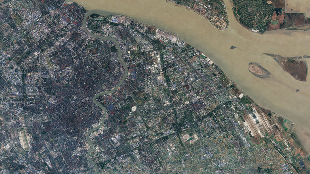
Earth observation image of the week: a Sentinel-2 image of Shanghai, also featured in the 200th edition of the Earth from Space video programme
Spolupracujeme na výzkumu využití UAV pro sběr dat železnice pro SŽDC
7.10.2016 9:09 UpVision Spolupracujeme s VŠB Technickou univerzitou na výzkumném úkolu možnosti využití UAV při sběru dat o železnici pro SŽDC.Několik fotek zde:
https://plus.google.com/+UpvisionCz1/posts/7YYffXLg25V
Geograf/Geografka
7.10.2016 8:58 ČÚZK /Urady/Zememericky-urad/Uredni-deska/Oznameni-a-jina-uredni-sdeleni/Volna-mista/Geograf-GeografkaGeograf/Geografka
7.10.2016 8:58 ČÚZK - volná místa Zeměměřický úřad, vypisuje výběrové řízení na místo Geograf/GeografkaGeograf/Geografka
7.10.2016 8:58 ČÚZK - předpisy a opatření Zeměměřický úřadvypisuje výběrové řízení na místo
Geograf/Geografka
Geograf/Geografka
7.10.2016 8:58 Zeměměřický úřad Zeměměřický úřadvypisuje výběrové řízení na místo
Geograf/Geografka
Minolta EP 2030
7.10.2016 6:55 ČÚZK - předpisy a opatřeníKatastrální úřad pro Liberecký kraj nabízí nepotřebný majetek k odkupu. Jedná se o kopírku A3.
Minolta EP 2030
Minolta EP 2030
7.10.2016 6:55 ČÚZK /Urady/Katastralni-urady/Katastralni-urady/Katastralni-urad-pro-Liberecky-kraj/Nabidky-majetku/Minolta-EP-2030Smaltovaný dvoudřez
7.10.2016 6:43 ČÚZK - předpisy a opatřeníKatastrální úřad pro Liberecký kraj nabízí nepotřebný majetek k odkupu. Jedná se o smaltovaný dvoudřez.
Smaltovaný dvoudřez
Smaltovaný dvoudřez
7.10.2016 6:43 ČÚZK /Urady/Katastralni-urady/Katastralni-urady/Katastralni-urad-pro-Liberecky-kraj/Nabidky-majetku/Smaltovany-dvoudrezGeologické kódovníky
7.10.2016 2:00 Cenia - Katalog metadat ČR - INSPIRE Databáze geologických kódovníků.Územní působnost poboček
7.10.2016 2:00 Cenia - Katalog metadat ČR - INSPIRE Působnost ČHMÚ je rozdělena do 7 poboček, 5 českých a 2 moravských. Jejich území je vymezeno hranicí ČR a základními rozvodnicemi:České Budějovice - povodí Vltavy po Orlík, Hradec Králové - povodí Labe po Výrovku a povodí Stěnavy, Plzeň - povodí Berounky po soutok s Klíčavou, Ohře po soutok s Bočským potokem a povodí Naabu a Regenu, Praha - povodí Vltavy pod Orlíkem, Labe pod Výrovkou po Vltavu a osa Labe od Vltavy po hranici, Ústí nad Labem - přítoky Labe pod Vltavou, povodí Lužické Nisy a Smědé, Ostrava - povodí Odry a Moravy po soutok s Bečvou a Brno - povodí Moravy pod soutokem s Bečvou a Dyje.Metadatový katalog VÚMOP
7.10.2016 2:00 Cenia - Katalog metadat ČR - INSPIRE Metadatový katalog VÚMOP je určen pro vyhledání informací o datových zdrojích a službách, které jsou ve správě Výzkumného ústavu meliorací a ochrany půdy, v.v.i. Pro práci s metadaty prostorových dat a služeb je využíván systém MICKA, který je v souladu s mezinárodními standardy ISO, OGC a INSPIRE.Kniha: Zpracování a analýza měření v inenýrské geodézii
6.10.2016 20:20 Zeměměřič - monografie z oboru teorie chyb a vyrovnávacího počtu - - 2. upravené a doplněné vydání, ČVUT, 2015 - - autory jsou doc. Ing. Miroslav Hampacher, CSc. a doc. Ing. Martin troner, Ph.D.technology&more 2016-4
6.10.2016 19:27 Geotronics.skZ aktuálneho čísla technology & more, vám prinášame pohľad na to, ako geopriestorové informácie menia prácu a život ľudí po celom svete. Dnes je pre ľudí úplne typické, že používajú svoje smartphony na prístup k mapám a k lokalizácii polohy… Prajeme zaujímavé čítanie
Príspevok technology&more 2016-4 zobrazený najskôr Geotronics Slovakia.
Sympozium HIS 2017 bude v Číně
6.10.2016 17:41 Česká kosmická kancelář
Ve dnech 27. až 30. listopadu 2017 se v čínském Šen-Čenu uskuteční 21. symposium Humans in space zaměřené na problematiku přítomnosti člověka v kosmickém prostoru a souvisejícího výzkumu a techniky. Symposium organizuje Mezinárodní astronautická akademie a Pekingský technologický institut. V roce 2015 sympozium hostila Praha.
Prověřená Ariane 5 podkládá základy pro Ariane 6
6.10.2016 15:53 Český Kosmický PortálNosná raketa Ariane 5 má nyní za sebou 74 úspěšných startů v řadě, čímž dosáhla spolehlivosti své předchůdkyně Ariane 4. A její aktuální experiment pomáhá při vývoji budoucí Ariane 6.
Prověřená Ariane 5 podkládá základy pro Ariane 6
6.10.2016 15:53 Český Kosmický PortálNosná raketa Ariane 5 má nyní za sebou 74 úspěšných startů v řadě, čímž dosáhla spolehlivosti své předchůdkyně Ariane 4. A její aktuální experiment pomáhá při vývoji budoucí Ariane 6.
20161006 - Oznámení působnosti v A123 v RPP
6.10.2016 15:16 ČÚZK /Uvod/Produkty-a-sluzby/RUIAN/RUIAN-novinky/2016/20161006-Oznameni-pusobnosti-v-A123-v-RPP20161006 - Oznámení působnosti v A123 v RPP
6.10.2016 15:16 ČÚZK - předpisy a opatření Ve vazbě na novelu zákona o základních registrech, která nabude účinnosti k 1. 1. 2017, obdrželi editoři RÚIAN od správce RPP výzvu k oznámení působnosti v agendě A123. Upozorňujeme, že OVM, které neoznámí působnost v A123 dle výzvy, se nebudou moci od 1. 1. 2017 přihlásit do ISÚI.Zveřejněno 6. 10. 2016
20161006 - Oznámení působnosti v A123 v RPP
6.10.2016 15:16 ČÚZK - předpisy a opatření Ve vazbě na novelu zákona o základních registrech, která nabude účinnosti k 1. 1. 2017, obdrželi editoři RÚIAN od správce RPP výzvu k oznámení působnosti v agendě A123.Upozorňujeme, že OVM, které neoznámí působnost v A123 dle výzvy do 31. 12. 2016, se nebudou moci přihlásit do ISÚI.
Zveřejněno 6. 10. 2016
20161006 - Oznámení působnosti v A123 v RPP
6.10.2016 15:16 ČÚZK - předpisy a opatření Ve vazbě na novelu zákona o základních registrech, která nabude účinnosti k 1. 1. 2017, obdrželi editoři RÚIAN od správce RPP výzvu k oznámení působnosti v agendě A123. Upozorňujeme, že OVM, které neoznámí působnost v A123 dle výzvy do 31. 12. 2016, se nebudou moci přihlásit do ISÚI.Zveřejněno 6. 10. 2016
Business in the ever-changing digital world
6.10.2016 15:15 ESA Observing the Earth
In an era of profound digital transformation, business leaders and IT experts are convening at ESA’s mission control in Darmstadt, Germany, today for the first SAP Digital Leaders’ Summit.
Geograf/ka
6.10.2016 14:22 Zeměměřický úřad Zeměměřický úřadvypisuje výběrové řízení na místo
Geograf/ka
Geograf/ka
6.10.2016 14:22 ČÚZK - předpisy a opatření Zeměměřický úřadvypisuje výběrové řízení na místo
Geograf/ka
Earth from Space
6.10.2016 14:00 ESA Observing the Earth
Join us Friday, 7 October, at 10:00 CEST for the 200th ‘Earth from Space’ video programme. This week features a Sentinel-2 image of Shanghai
20161006-VŘ Řízení projektů
6.10.2016 13:57 ČÚZK - předpisy a opatření Oznámení o vyhlášení výběrového řízení na služební místo - Řízení projektů - zde.20161006-VŘ Řízení projektů
6.10.2016 13:57 ČÚZK - předpisy a opatření Oznámení o vyhlášení výběrového řízení na služební místo - Řízení projektů - zde.Řízení projektů
6.10.2016 13:53 ČÚZK - předpisy a opatření Český úřad zeměměřický a katastrálnívypisuje výběrové řízení na místo
Řízení projektů
Řízení projektů
6.10.2016 13:53 ČÚZK - volná místa Český úřad zeměměřický a katastrální, vypisuje výběrové řízení na místo Řízení projektůMapová aplikace Územně analyti
6.10.2016 12:00 Jihočeský kraj Mapová aplikace Územně analytické podklady byla aktualizována k 5. 10. 2016.V mapové aplikaci byla přidán
6.10.2016 12:00 Jihočeský kraj V mapové aplikaci byla přidána územně plánovací dokumentace obcí: Cep, České Velenice, Domanín, Opařany, Probulov, Předotice a Střítež. Dále pak byla aktualizována územně plánovací dokumentace u obcí: Čížkrajice, Dynín, Hamr, Jivno, Kájov, Kovářov, Protivín, Vlachovo Březí a Zdíkov.V mapové aplikaci Územně pláno
6.10.2016 12:00 Jihočeský kraj V mapové aplikaci Územně plánovací dokumentace obcí byla přidána územně plánovací dokumentace obcí: Cep, České Velenice, Domanín, Opařany, Probulov, Předotice a Střítež. Dále pak byla aktualizována územně plánovací dokumentace u obcí: Čížkrajice, Dynín, Hamr, Jivno, Kájov, Kovářov, Protivín, Vlachovo Březí a Zdíkov.Mapová aplikace byla aktualiz
6.10.2016 12:00 Jihočeský kraj Mapová aplikace byla aktualizována k 5. 10. 2016.2016
6.10.2016 10:30 ČÚZK /Urady/Katastralni-urady/Katastralni-urady/Katastralni-urad-pro-Plzensky-kraj/Casto-hledane-informace/Poskytovani-informaci-106-1999-Sb/Zverejneni-obsahu-informaci-poskytnutych-na-za-(1)/20162016
6.10.2016 10:30 ČÚZK - předpisy a opatření Katastrální úřad pro Plzeňský krajzveřejňuje obsah informace poskytnutých na žádost dle zákona č. 106/1999 Sb. za rok
2016
2015
6.10.2016 10:05 ČÚZK - předpisy a opatření Katastrální úřad pro Plzeňský krajvydává výroční zprávu úřadu za rok
2015
2015
6.10.2016 10:05 ČÚZK /Urady/Katastralni-urady/Katastralni-urady/Katastralni-urad-pro-Plzensky-kraj/Vyrocni-zpravy/2015Visit Carlson Software at Intergeo, October 11-13
6.10.2016 9:51 Carlson Software All those heading to Hamburg, Germany, for Intergeo this October 11 to 13 are invited to stop by and visit Carlson Software in hall A3, stand D3.051. Intergeo, which consists of a conference and a trade fair, is held every fall at a different venue in Germany. It’s a real treat for those in the […]GeoMoodle – odstávka 7. 10. 2016
6.10.2016 5:55 Katedra geografie UP Olomouc V pátek 7. 10. 2016 bude server geomoodle.upol.cz plánovaně mimo provoz z důvodu nutného technického zásahu s cílem odstranit nestabilitu serveru, ke které dochází v poslední době. Za vzniklé komplikace se omlouváme a děkujeme za pochopení.vedoucí oddělení právních vztahů k nemovitostem
5.10.2016 12:37 ČÚZK /Urady/Katastralni-urady/Katastralni-urady/Katastralni-urad-pro-Plzensky-kraj/Uredni-deska/Oznameni-a-jina-uredni-sdeleni/Volna-mista/vedouci-oddeleni-pravnich-vztahu-k-nemovitostemvedoucí oddělení právních vztahů k nemovitostem
5.10.2016 12:37 ČÚZK - volná místa Katastrální úřad pro Plzeňský kraj, Katastrální pracoviště Tachov vypisuje výběrové řízení na místo vedoucí oddělení právních vztahů k nemovitostemvedoucí oddělení právních vztahů k nemovitostem
5.10.2016 12:37 ČÚZK - předpisy a opatření Katastrální úřad pro Plzeňský kraj Katastrální pracoviště Tachovvypisuje výběrové řízení na místo
vedoucí oddělení právních vztahů k nemovitostem
ČGS – Cestovatelský úterek 11. 10. 2016 (Putování k Baltu)
5.10.2016 12:31 Katedra geografie UP Olomouc Zveme Vás na přednášku v cyklu Cestovatelské úterkyBez kvaltu k Baltu: přes Česko a Polsko k Baltskému moři
která se uskuteční v úterý 11. října 2016 od 18.30 do 20.00 na učebně LP 2005. Přednáší Ondřej Herzán (pozvánka).
V Geoportálu ÚAP Ústeckého kra
5.10.2016 12:00 Ústecký kraj V Geoportálu ÚAP Ústeckého kraje byla provedena aktualizace údajů pro poskytovatele Ústecký kraj – krajský úřad, odbor dopravy a silničního hospodářství – jev 91, 92Plzeňský kraj uzavřel nové sml
5.10.2016 12:00 Plzeňský kraj Plzeňský kraj uzavřel nové smluvní vztahy k projektu Digitální technická mapa Plzeňského kraje s městy Bělá nad Radbuzou, Stříbro a Sušice. Po nabytí účinnosti vyhlášek o vedení technických map těchto měst budou informace uveřejněny formou novinek. Přehled uzavřených partnerských smluv v mapě je k dispozici zde.Plzeňský kraj uzavřel nové sml
5.10.2016 12:00 Plzeňský kraj Plzeňský kraj uzavřel nové smluvní vztahy k projektu Digitální technická mapa Plzeňského kraje (http://geoportal.plzensky-kraj.cz/gs/digitalni-technicka-mapa/) s městy Bělá nad Radbuzou, Stříbro a Sušice. Po nabytí účinnosti vyhlášek o vedení technických map těchto měst budou informace uveřejněny formou novinek. Přehled uzavřených partnerských smluv v mapě je k dispozici zde (http://mapy.kr-plzensky.cz/gis/dtm_smlouvy_obce).Natáčeli jsme po Praze tramvaje pro dokument Dopravního podniku
5.10.2016 10:10 UpVision Na několika místech v Praze jsme s povolením od ÚCL natáčeli letecké záběry pro připravovaný dokument o jedné tramvaji pro Dopravní podnik.Několik fotek zde:
https://plus.google.com/+UpvisionCz1/posts/E5pEqhY6At5
GNSS User Technology: A rapidly evolving landscape
5.10.2016 9:03 European GNSS Agency
What lies ahead in the GNSS chipset and receiver domain and what are the trends sure to transform the GNSS landscape of tomorrow? Download the GSA’s first GNSS User Technology Report now to find out.
In recent years, GNSS technology has experienced a period of rapid development – both on the side of global constellations and user receivers. With this development, European systems such as EGNOS and Galileo are becoming increasingly present in GNSS receivers, providing enhanced performance to users both in Europe and worldwide. Even with the increased deployment of other positioning technologies, because it is the most widespread and cost-effective source of location information, GNSS will remain at the core of all positioning technology.
“In view of the changing user needs in terms of expected positioning experiences, the appearance of new and modernised GNSS signals, and advances in semiconductor technologies, we felt the need to take a closer look at the impact these changes will have on user technology and GNSS’ role in the positioning solutions of the future,” says GSA Executive Director Carlo des Dorides.
A closer look
The outcome of this closer look is the GSA’s first GNSS User Technology Report. As a sister publication to the GNSS Market Report, the GNSS User Technology Report zeros in on the state-of-the-art GNSS receiver technology, along with analysing the trends that are sure to change the entire GNSS landscape. The Report provides an in-depth analysis of GNSS user technology as it pertains to the three key macrosegments of mass market solutions; transport safety and liability-critical solutions; and high precision, timing and asset management solutions. In addition, the Report gives a general overview of the latest GNSS receiver technology, common to all application areas, along with a supplement on location technologies that looks beyond GNSS in the positioning landscape.
Written with contributions from leading GNSS receiver and chipset manufacturers, the GNSS User Technology Report is meant to serve as a valuable tool to support planning and decision-making in regards to developing, purchasing and using GNSS user technology. “GNSS user technology is, now more than ever, experiencing a rapid and exciting evolution, answering the needs of ubiquity, automation and secure positioning,” adds des Dorides. “This report explores in detail all of these new developments and how they will bring continuous location service, reliability and robustness to the main application domains.”
The Report is free and can be downloaded here.
Did You Know? |
|
A note on methodology
The GNSS User Technology Report uses the GSA’s internal Technology Monitoring process (TMP).
It complements the market monitoring and forecasting process, and its objective is the monitoring of trends and developments in the GNSS supply industry. It supports the GSA in the definition of the best strategy towards Galileo market adoption, provision of updated statistics on Galileo penetration in user terminals and chipsets, and analysing Galileo positioning among other GNSS and location technologies.
Part of the process is to keep up-to-date independent analysis, which assesses the capabilities of receivers, chipsets and modules currently available on the market. For the analysis, each device is weighted equally, regardless of whether it is a chipset or a receiver, and no matter what its sales volume is. The results should therefore be interpreted not as the split of constellations utilised by end users, but rather the split of constellations available in manufacturers’ offerings.
The analysis includes all major receiver manufacturers in Europe and worldwide: Avidyne, Broadcom, CSR, Esterline, Furuno, Garmin, Hemisphere GNSS, Honeywell, Infineon, Intel, Japan Radio Co., John Deere, Kongsberg, Leica Geosystems AG, Mediatek, NavCom Technology,
Nottingham Scientific Ltd, NovAtel, Omnicom, Orolia, Qualcomm, Rockwell Collins, Septentrio, SkyTraq Technology, STMicroelectronics, Texas Instruments, Thales Avionics, Topcon, Trimble, U-blox, Universal Aviation.
Search and Rescue, defence and public utilities receivers, chipsets and modules are not part of the analysis.
The information contained within the Report is a compilation of in-house knowledge, desk research, scientific papers, receiver and other user technology manufacturer’s websites and, if needed, verified by consultation with experts in the relevant domain.
Media note: This feature can be republished without charge provided the European GNSS Agency (GSA) is acknowledged as the source at the top or the bottom of the story. You must request permission before you use any of the photographs on the site. If you republish, we would be grateful if you could link back to the GSA website (http://www.gsa.europa.eu).
Zeměměřič 9+10/2016 právě vyšel
5.10.2016 8:10 Zeměměřič Bůh přeměřuje Zemije tématem motivu obálky tohoto čísla. Snad si kadý tento obrázek vystavíte na svém pracoviti, aby vám připomínal to, co vám chce sdělit i článek se stejným názvem. Od pradávna si toti vládci v různých světových kulturách přivlastňovali práci zeměměřičů, protoe tak zvýrazňovali svůj boský původ.
Měření Země a veho na ní i mimo ní je boská práce, která je nám svěřena a my ji musíme dělat pořádně, zodpovědně a důstojně. Dokud si i ten ná nejposlednějí ňouma v teplákách a s pásmem neuvědomí mimořádnost naeho oboru, budeme se (třeba i nechtěně) podílet na jeho devastaci a zániku.
odborný referent v oddělení dokumentace KN (1)
5.10.2016 6:29 ČÚZK /Urady/Katastralni-urady/Katastralni-urady/Katastralni-urad-pro-Jihomoravsky-kraj/Uredni-deska/Oznameni-a-jina-uredni-sdeleni/Volna-mista/odborny-referent-v-oddeleni-dokumentace-KN-(4)odborný referent v oddělení dokumentace KN (1)
5.10.2016 6:29 ČÚZK - předpisy a opatření Katastrální úřad pro Jihomoravský kraj Katastrální pracoviště Hodonínnabízí služební místo
odborný referent v oddělení dokumentace KN
odborný referent v oddělení dokumentace KN (1)
5.10.2016 6:29 ČÚZK - volná místa Katastrální úřad pro Jihomoravský kraj, Katastrální pracoviště Hodonín vypisuje výběrové řízení na místo odborný referent v oddělení dokumentace KN (1)Státní pozemkový úřad pořádá konferenci o pozemkových úpravách jako účinném nástroji v boji proti suchu
5.10.2016 0:00 Státní pozemkový úřad Praha, 5. října 2016 – Ve dnech 5. a 6. října 2016 se koná XIX. Konference pozemkové úpravy. Tato tradiční konference letos probíhá pod názvem „Pozemkové úpravy jako nástroj adaptace na měnící se klima“ a při příležitosti 25. výročí zákona o pozemkových úpravách a pozemkových úřadech.Claire Rutkowski Named Bentley Systems' CIO
4.10.2016 22:42 Bentley SystemsRutkowski Brings Engineering Firm Leadership Experience; Joins Bentley’s Executive Cabinet
EXTON, Pa., U.S.A. – Bentley Systems, Incorporated, a leading global provider of comprehensive software solutions for advancing infrastructure, today announced that Claire Rutkowski has joined Bentley as chief information officer and will lead Bentley’s global IT organization, shaping and delivering a technology agenda across Bentley’s global business. She will collaborate with executive and business leadership teams to ensure Bentley leverages the most advanced technology solutions to achieve the business goals of Bentley and its users. Ms. Rutkowski joins the company’s executive cabinet and reports to David Hollister, operations advancement officer at Bentley.
Ms. Rutkowski comes to Bentley from MWH Global where she served as chief information officer and was responsible for delivering IT strategy, services, and support to 7,000 engineering professionals globally. Rutkowski joined MWH in 1998 and served in several global and regional leadership positions during her career.
Commenting on Ms. Rutkowski’s appointment, David Hollister said, “Claire is an accomplished IT professional and a strategic thinker who has a history of executing with precision. Her career has thrived with a commitment to quality, a passion for collaboration, and a knack for helping her colleagues leverage technology to improve the way they collaborate across global teams. She also brings to Bentley a valuable perspective gained from serving as CIO at one of our large user organizations. We are confident that Claire will energetically advance our IT organization and our cloud and managed services infrastructure to the next level, bringing further innovation, quality, credibility, and value to our internal stakeholders and external users alike.”
Ms. Rutkowski holds a bachelor’s degree from Penn State University, a professional project management certification, and a specialist certificate in IT project management. She has won several awards, notably iCMG’s Global CIO of the Year Award, Constructech’s Top 50 Women in Construction Award, a Stevie Award for Women in Business, and a Vision Award for the application of virtual reality to engineering and construction projects. Ms. Rutkowski has been a featured speaker at Oracle, Gartner, and Project Management Institute conferences.
About Bentley Systems
Bentley Systems is a global leader in providing architects, engineers, geospatial professionals, constructors, and owner-operators with comprehensive software solutions for advancing the design, construction, and operations of infrastructure. Bentley users leverage information mobility across disciplines and throughout the infrastructure lifecycle to deliver better-performing projects and assets. Bentley solutions encompass MicroStation applications for information modeling, ProjectWise collaboration services to deliver integrated projects, and AssetWise operations services to achieve intelligent infrastructure – complemented by worldwide professional services and comprehensive managed services.
Founded in 1984, Bentley has more than 3,000 colleagues in over 50 countries, more than $600 million in annual revenues, and since 2009 has invested more than $1 billion in research, development, and acquisitions.
Additional information about Bentley is available at www.bentley.com. For Bentley news as it happens, subscribe to an RSS feed of Bentley press releases and news alerts. Visit The Year in Infrastructure Conference website for information about Bentley’s premier thought-leadership event. To view a searchable collection of innovative infrastructure projects from the annual Be Inspired Awards, access Bentley’s Infrastructure Yearbooks. To access a professional networking site that enables members of the infrastructure community to connect, communicate, and learn from each other, visit Bentley Communities.
To download the Bentley Infrastructure 500 Top Owners ranking, a unique global compendium of the top public- and private-sector owners of infrastructure based on the value of their cumulative infrastructure investments, visit BI 500.
# # #
Bentley, the “B” Bentley logo, Be, MicroStation, and ProjectWise are either registered or unregistered trademarks or service marks of Bentley Systems, Incorporated or one of its direct or indirect wholly owned subsidiaries. All other brands and product names are trademarks of their respective owners.
Úspěch v soutěži European Business Awards
4.10.2016 14:17 HrdličkaSoutěž oceňuje nejdynamičtější evropské společnosti, které tak mohou sdílet svůj příběh, přístup k inovacím a firemní etice. Cílem soutěže je podpora úspěšné podnikatelské komunity napříč celou Evropou. „Jsme hrdí na náš úspěch v soutěži celoevropského formátu European Business Awards. Během 25 let existence společnosti jsme se vždy snažili rozvíjet naše aktivity v reakci na potřeby... View Article
The post Úspěch v soutěži European Business Awards appeared first on HRDLIČKA spol. s r.o. - komplexní služby v oblasti geodézie.
Sustainable cities
4.10.2016 14:00 ESA Observing the Earth
Four climate change and urban development experts join the show to discuss how satellite data can be used to promote sustainable cities
Studijní pobyty CEEPUS
4.10.2016 11:06 Katedra geografie UP Olomouc Do konce října mohou studenti podávat přihlášky na krátkodobé studijní pobyty v rámci programu CEEPUS, které budou realizovány v letním semestru 2017. V nabídce jsou univerzity v Chorvatsku (Záhřeb, 1 osoba / 2 měsíce) a v Srbsku (Novi Sad, 1 osoba / 1 měsíc). Je však také možné se přihlásit nad rámec kvót i do jiných destinací. V případě zájmu kontaktujte do 21. října dr. Šimáčka (petr.simacek@upol.cz).20161004-seznam úředně opráv. zeměměřických inženýrů
4.10.2016 10:51 ČÚZK - předpisy a opatření Aktualizovaný seznam úředně oprávněných zeměměřických inženýrů zde.20161004-seznam úředně opráv. zeměměřických inženýrů
4.10.2016 10:51 ČÚZK /Aktuality-resort/20161004-seznam-uredne-oprav-zememerickych-inzenyr20161004-seznam úředně opráv. zeměměřických inženýrů
4.10.2016 10:51 ČÚZK - předpisy a opatření Aktualizovaný seznam úředně oprávněných zeměměřických inženýrů zde.20161004-seznam úředně opráv. zeměměřických inženýrů
4.10.2016 10:51 ČÚZK /Aktuality-resort/2016/20161004-seznam-uredne-oprav-zememerickych-inzenyrDoprovodný program konference
4.10.2016 8:35 ARCDATAPokud jste se zatím nepřihlásili na letošní Konferenci GIS Esri v ČR, do konce týdne ještě máte možnost přihlásit se s uplatněním slevy na vstupném.
Hlavní program konference nabídne více než 20 hodin přednášek a workshopů, vedle toho se můžete těšit i na bohatý doprovodný program. Připravujeme pro vás například:
- krátké tematické workshopy přímo na stánku technické podpory,
- velké množství map,
- interaktivní prezentace internetových aplikací,
- výstavu soutěžních posterů a soutěž v poznávání družicových snímků,
- mobilní soupravu hydrometeorologického zabezpečení Armády ČR
- a mnoho dalšího.
Přihlaste se proto nejpozději do tohoto pátku 7. 10. a využijte svoji slevu z registračního poplatku.
INSPIRE stahovací služba WFS pro téma Dopravní sítě-lanová dráha (TN_CABLE)
4.10.2016 2:00 Cenia - Katalog metadat ČR - INSPIRE INSPIRE stahovací služba WFS pro téma Dopravní sítě-lanová dráha(TN_CABLE) je služba umožňující registrovaným uživatelům opakované stahování dat pomocí technologie WFS 2.0.0. Stahovací služba poskytuje harmonizovaná data INSPIRE tématu Dopravní sítě-lanová dráha(TN_CABLE) odpovídající INSPIRE xml schématu ve verzi 4.0. Data jsou poskytována ve formátu GML 3.2.1. a v souřadnicovém systému ETRS89/TM33 stanoveném INSPIRE pro zobrazení dat velkých měřítek. Tato datová sada dopravních sítí České republiky má proto jednotnou podobu s ostatními daty vytvářenými pro toto INSPIRE téma v rámci celé Evropy. Základem poskytované datové sady je Základní báze geografických dat České republiky (ZABAGED®). Služba splňuje technické pokyny pro INSPIRE stahovací služby verze 3.1 a zároveň splňuje standard OGC WFS 2.0.0.INSPIRE téma Adresy (AD)
4.10.2016 2:00 Cenia - Katalog metadat ČR - INSPIRE Data odpovídají směrnici INSPIRE pro téma adresy (AD). Vychází především z projektu RÚIAN (Registr územní identifikace, adres a nemovitostí), který je součástí základních registrů České Republiky a obsahuje informace o územní identifikaci, adresách a nemovitostech. Data publikovaná v rámci INSPIRE obsahují pouze adresní místa a jejich komponenty, kterými jsou stát, obec, část obce, městský obvod v Praze (MOP), městký obvod/městská část (MO/MČ), ulice a pošta a to na území celé České Republiky. Obsahují rozvněž geometrii, která určuje definiční bod adresního místa. V datové sadě nění uvedeno 2,55%, t.j. 74096 adresních míst (k 03. 10. 2016), protože neobsahují definiční bod, podle kterého by je bylo možné prostorově určit. Více v zákoně č. 111/2009 Sb., o základních registrech a ve vyhlášce č. 359/2011 Sb., o základním registru územní identifikace, adres a nemovitostí v platných zněních a INSPIRE Data Specification on Addresses v 3.0.1 z 26.4.2010.Centrální režimová databáze množství povrchových vod
4.10.2016 2:00 Cenia - Katalog metadat ČR - INSPIRE Za kalendářní rok 2014 byly do databáze uloženy vodní stavy a průtoky z 520 vodoměrných stanic, teplota vody ze 170 stanic a plaveniny ze 40 stanic. Více než 90% měření se provádí pomocí automatických stanic, a to buď smístním záznamem nebo s dálkovým přenosem. Pozorované vodní stavy se převádějí na průtoky pomocí měrných křivek, které se stanovují na základě hydrometrických měření. Do databáze se ukládají verifikované okamžité, průměrné hodinové a průměrné denní vodní stavy; průměrné hodinové a průměrné denní průtoky; okamžité měsíční kulminační průtoky. U teplot vody se ukládají ranní měřené teploty nebo kontinuálně měřené okamžité a průměrné denní hodnoty. U plavenin se jedná o okamžité a průměrné denní koncentrace, v závislosti na typu měření. Dále se ukládají hydrometrická měření, měrné křivky průtoků, příčné profily a popisnéúdaje vodoměrných stanic. U hraničních profilů se data průtoků odsouhlasují se sousedním státem.Datové řady jsou uloženy za celé období pozorování jednotlivých stanic, přičemž nejdelší řada průměrných denních průtoků je pro stanici Děčín na Labi od roku 1888.CRDPZV - centrální režimová databáze podzemních vod
4.10.2016 2:00 Cenia - Katalog metadat ČR - INSPIRE V roce 2014 byla do CRDPZV uložena data z 1812 objektů podzemních vod - stavy hladin z 1487 vrtů a vydatnosti z 325 pramenů. U vybraných pramenů se měří i ukládá teplota podzemní vody. Většina objektů je osazena automatickými stanicemi s místním záznamem nebo s přenosem dat, které měří 1x denně. Některé prameny ještě sledují dobrovolní pozorovatelé s četností měření 1x týdně a to ve středu. Většina dat je uložena od roku 1971 s četností měření 1x týdně. V 90-tých letech začala první pozorování pomocí automatických stanic s četností měření 1x denně. Nejvíce nových objektů bylo vybudováno v rámci projektu ISPA a zprovozněno v roce 2007. Ukládají se vodní stavy, vydatnosti, teploty, kontrolní měření a popisné údaje objektů.INSPIRE stahovací služba WFS pro téma Vodstvo (HY)
4.10.2016 2:00 Cenia - Katalog metadat ČR - INSPIRE INSPIRE stahovací služba WFS pro téma Vodstvo (HY) je služba umožňující registrovaným uživatelům opakované stahování dat pomocí technologie WFS 2.0.0. Stahovací služba poskytuje harmonizovaná data INSPIRE tématu Vodstvo (HY) odpovídající INSPIRE xml schématu ve verzi 4.0. Data jsou poskytována ve formátu GML 3.2.1. a v souřadnicovém systému ETRS89/TM33 stanoveném INSPIRE pro zobrazení dat velkých měřítek.Tato datová sada vodstva České republiky má proto jednotnou podobu s ostatními daty vytvářenými pro toto INSPIRE téma v rámci celé Evropy. Základem poskytované datové sady je Základní báze geografických dat České republiky (ZABAGED®). V současné době jsou poskytována data pro aplikační schéma pro fyzické vody. Služba splňuje technické pokyny pro INSPIRE stahovací služby verze 3.1 a zároveň splňuje standard OGC WFS 2.0.0.INSPIRE téma Budovy (BU)
4.10.2016 2:00 Cenia - Katalog metadat ČR - INSPIRE Data odpovídají směrnici INSPIRE pro téma budovy (BU). Data pochází částečně z projektu RÚIAN (Registr územní identifikace, adres a nemovitostí), který je součástí základních registrů České Republiky a obsahuje informace o územní identifikaci, adresách a nemovitostech, a částečně z ISKN (Informační systém katastru nemovistostí). Zdrojem informací o budovách v ISKN je objekt Stavba, v RÚIAN je to Stavební objekt. Většina Staveb je zároveň Stavebními objekty, ale jsou případy, kdy tomu tak není. Kromě Budov datová sada obsahuje i části budov, které jsou pro potřeby INSPIRE vyjádřeny vchody z RÚIAN. Vchody obsahují informace o počtu podlaží, technickoekonomických atributech apod. Datová sada pokrývá celé území české republiky. V datové sadě není uvedeno 2,09%, t.j. 87882 budov (k 03. 10. 2016), protože neobsahují definiční bod ani polygon. Více v zákoně č. 111/2009 Sb., o základních registrech, ve vyhlášce č. 359/2011 Sb., o základním registru územní identifikace, adres a nemovitostí v platných zněních, v zákoně 256/2013 Sb., o katastru nemovitostí, v katastrální vyhlášce č. 357/2013 Sb. v platném znění a INSPIRE Data Specification on Buildings v 3.0 z 13.12.2013.INSPIRE stahovací služba WFS pro téma Dopravní sítě-silniční doprava (TN_ROAD)
4.10.2016 2:00 Cenia - Katalog metadat ČR - INSPIRE INSPIRE stahovací služba WFS pro téma Dopravní sítě-silniční doprava (TN_ROAD) je služba umožňující registrovaným uživatelům opakované stahování dat pomocí technologie WFS 2.0.0. Stahovací služba poskytuje harmonizovaná data INSPIRE tématu Dopravní sítě-silniční doprava (TN_ROAD) odpovídající INSPIRE xml schématu ve verzi 4.0. Data jsou poskytována ve formátu GML 3.2.1. a v souřadnicovém systému ETRS89/TM33 stanoveném INSPIRE pro zobrazení dat velkých měřítek. Tato datová sada dopravních sítí České republiky má proto jednotnou podobu s ostatními daty vytvářenými pro toto INSPIRE téma v rámci celé Evropy. Základem poskytované datové sady je Základní báze geografických dat České republiky (ZABAGED®). Služba splňuje technické pokyny pro INSPIRE stahovací služby verze 3.1 a zároveň splňuje standard OGC WFS 2.0.0.INSPIRE stahovací služba WFS pro téma Dopravní sítě-železniční doprava (TN_RAIL)
4.10.2016 2:00 Cenia - Katalog metadat ČR - INSPIRE INSPIRE stahovací služba WFS pro téma Dopravní sítě-železniční doprava (TN_RAIL) je služba umožňující registrovaným uživatelům opakované stahování dat pomocí technologie WFS 2.0.0. Stahovací služba poskytuje harmonizovaná data INSPIRE tématu Dopravní sítě-železniční doprava (TN_RAIL) odpovídající INSPIRE xml schématu ve verzi 4.0. Data jsou poskytována ve formátu GML 3.2.1. a v souřadnicovém systému ETRS89/TM33 stanoveném INSPIRE pro zobrazení dat velkých měřítek. Tato datová sada dopravních sítí České republiky má proto jednotnou podobu s ostatními daty vytvářenými pro toto INSPIRE téma v rámci celé Evropy. Základem poskytované datové sady je Základní báze geografických dat České republiky (ZABAGED®). Služba splňuje technické pokyny pro INSPIRE stahovací služby verze 3.1 a zároveň splňuje standard OGC WFS 2.0.0.INSPIRE stahovací služba WFS pro téma Dopravní sítě-vodní doprava (TN_WATER)
4.10.2016 2:00 Cenia - Katalog metadat ČR - INSPIRE INSPIRE stahovací služba WFS pro téma Dopravní sítě-vodní doprava (TN_WATER) je služba umožňující registrovaným uživatelům opakované stahování dat pomocí technologie WFS 2.0.0. Stahovací služba poskytuje harmonizovaná data INSPIRE tématu Dopravní sítě-vodní doprava (TN_WATER) odpovídající INSPIRE xml schématu ve verzi 4.0. Data jsou poskytována ve formátu GML 3.2.1. a v souřadnicovém systému ETRS89/TM33 stanoveném INSPIRE pro zobrazení dat velkých měřítek. Tato datová sada dopravních sítí České republiky má proto jednotnou podobu s ostatními daty vytvářenými pro toto INSPIRE téma v rámci celé Evropy. Základem poskytované datové sady je Základní báze geografických dat České republiky (ZABAGED®). Služba splňuje technické pokyny pro INSPIRE stahovací služby verze 3.1 a zároveň splňuje standard OGC WFS 2.0.0.INSPIRE stahovací služba WFS pro téma Dopravní sítě-letecká doprava (TN_AIR)
4.10.2016 2:00 Cenia - Katalog metadat ČR - INSPIRE INSPIRE stahovací služba WFS pro téma Dopravní sítě-letecká doprava (TN_AIR) je služba umožňující registrovaným uživatelům opakované stahování dat pomocí technologie WFS 2.0.0. Stahovací služba poskytuje harmonizovaná data INSPIRE tématu Dopravní sítě-letecká doprava (TN_AIR) odpovídající INSPIRE xml schématu ve verzi 4.0. Data jsou poskytována ve formátu GML 3.2.1. a v souřadnicovém systému ETRS89/TM33 stanoveném INSPIRE pro zobrazení dat velkých měřítek. Tato datová sada dopravních sítí České republiky má proto jednotnou podobu s ostatními daty vytvářenými pro toto INSPIRE téma v rámci celé Evropy. Základem poskytované datové sady je Základní báze geografických dat České republiky (ZABAGED®). Služba splňuje technické pokyny pro INSPIRE stahovací služby verze 3.1 a zároveň splňuje standard OGC WFS 2.0.0.INSPIRE stahovací služba WFS pro téma Zeměpisná jména (GN)
4.10.2016 2:00 Cenia - Katalog metadat ČR - INSPIRE INSPIRE stahovací služba WFS pro téma Zeměpisná jména (GN) je služba umožňující registrovaným uživatelům opakované stahování dat pomocí technologie WFS 2.0.0. Stahovací služba poskytuje harmonizovaná data INSPIRE tématu Zeměpisná jména (GN) odpovídající INSPIRE xml schématu ve verzi 4.0. Data jsou poskytována ve formátu GML 3.2.1. a v souřadnicovém systému ETRS89/TM33 stanoveném INSPIRE pro zobrazení dat velkých měřítek. Tato datová sada geografických jmen České republiky má proto jednotnou podobu s ostatními daty vytvářenými pro toto INSPIRE téma v rámci celé Evropy. Základem poskytované datové sady je databáze geografických jmen České republiky Geonames, ke které jsou doplněna jména objektů, která jsou obsažena v Základní bázi geografických dat České republiky (ZABAGED®), ale nejsou součástí Geonames (jména ulic a náměstí, dopravních uzlů a chráněných území). Služba splňuje technické pokyny pro INSPIRE stahovací služby verze 3.1 a zároveň splňuje standard OGC WFS 2.0.0.INSPIRE téma Parcely (CP)
4.10.2016 2:00 Cenia - Katalog metadat ČR - INSPIRE Data odpovídají směrnici INSPIRE pro téma katastrální parcely (CP). Vychází z katastrální mapy, která je závazným státním mapovým dílem velkého měřítka, obsahuje body polohového bodového pole, polohopis a popis a může mít formu digitální mapy, analogové mapy nebo digitalizované mapy. Data publikovaná v rámci INSPIRE obsahují pouze katastrální území (pro celou Českou Republiku) a parcely a jejich hranice z území, kde je digitální mapa (k 03. 10. 2016 je to 85,74% území České republiky, t.j. 67 621,11km2). Více katastrální zákon 256/2013 Sb., katastrální vyhláška č.357/2013 Sb. v platném znění a INSPIRE Data Specification on Cadastral Parcels v 3.0.1.Státní pozemkový úřad spolupracuje se správci vodních toků na řešení nedostatku vody
4.10.2016 0:00 Státní pozemkový úřad Praha, 4. října 2016 – Ústřední ředitelka Státního pozemkového úřadu Svatava Maradová dnes podepsala spolu s generálními řediteli státních podniků Povodí Labe a Povodí Odry Mariánem Šebestou a Jiřím Pagáčem dohodu o vzájemné spolupráci. Obdobná dohoda se státním podnikem Povodí Moravy byla podepsána 27. září 2016.Referent/referentka oddělení privatizace a převodů, Krajský pozemkový úřad pro Karlovarský kraj
4.10.2016 0:00 Státní pozemkový úřad Státní pozemkový úřad přijme zaměstnance na pozici referent/referentka oddělení privatizace a převodů, Krajský pozemkový úřad pro Karlovarský kraj.Den s INSPIRE - Pozvánka
3.10.2016 21:07 Zeměměřič Seminář se uskuteční dne 11. 11. 2016 na Novotného lávce v Praze.Magnetic oceans and electric Earth
3.10.2016 18:30 ESA Observing the Earth
Oceans might not be thought of as magnetic, but they make a tiny contribution to our planet’s protective magnetic shield. Remarkably, ESA’s Swarm satellites have not only measured this extremely faint field, but have also led to new discoveries about the electrical nature of inner Earth.
20161003-vyšší verze schémat XML
3.10.2016 14:00 ČÚZK - předpisy a opatření ČÚZK přešel na vyšší verzi schémat XML (XSD 4.0) při poskytování INSPIRE datových sad a služeb. Více zde.20161003-vyšší verze schémat XML
3.10.2016 14:00 ČÚZK - předpisy a opatřeníČÚZK přešel na vyšší verzi schémat XML (XSD 4.0) při poskytování INSPIRE datových sad a služeb. Více zde.