


![]()

zprávy
zdroje zpráv:V sekci Směrnice a metodiky (h
19.8.2016 12:00 Plzeňský kraj V sekci Směrnice a metodiky (http://geoportal.plzensky-kraj.cz/gs/smernice-a-metodiky/) je k dispozici aktualizovaný dokument Vizualizace jevů Územně analytických podkladů a Územních plánů Datového modelu T-MAPY verze 3.4. O samotnou vizualizaci pro ArcGIS mohou registrovaní uživatelé požádat prostřednictvím aplikace HelpDesk (https://geoportal.plzensky-kraj.cz/tw/ost/gp/helpdesk/requirements).V sekci Směrnice a metodiky je
19.8.2016 12:00 Plzeňský kraj V sekci Směrnice a metodiky je k dispozici aktualizovaný dokument Vizualizace jevů Územně analytických podkladů a Územních plánů Datového modelu T-MAPY verze 3.4. O samotnou vizualizaci pro ArcGIS mohou registrovaní uživatelé požádat prostřednictvím aplikace HelpDesk.Blíží se 2. konference Aliance pro bezpilotní letecký průmysl
19.8.2016 10:02 UpVision A je tu zase po roce druhý ročník Konference Aliance pro bezpilotní letecký průmysl, která se koná 14.9.2016 v Praze na ČZU. Součástí letošní konference bude i expozice nejnovějších řešení členů Aliance.Podrobný program konference naleznete na www.uava.cz/konference, v případě dotazů nás neváhejte kontaktovat na info@uava.cz.
Registrovat se můžete na http://uava-konference-1-2016.takeplace.eu/cs
Přijďte nás navštívit, budeme se těšit.
Jakub bude na pozvání speaker v Londýně na Commercial UAV Show 2016
19.8.2016 10:02 UpVision Letos v říjnu bude Jakub na pozvání speaker v Londýně na jedné z největších světových UAV Show, konkrétně na Commercial UAV Show 2016.Více zde:
http://www.terrapinn.com/exhibition/the-commercial-uav-show/speaker-jakub-KARAS.stm
Příběhy míst – pomozte se sběrem příběhů z Liberecka
19.8.2016 8:29 GISportal.cz Projekt „Příběhy míst“ si klade za cíl sesbírat historické informace o místech v regionu, sahajícím od německé Žitavy až po Vrchlabí. V jeho druhé fázi, v roce 2016, je sběr rozšířen z informací o vrcholech ...INSPIRE prohlížecí služba pro téma Využití území - kraj Plzeňský
19.8.2016 2:00 Cenia - Katalog metadat ČR - INSPIRE Uveřejnění zásad územního rozvoje Plzeňského kraje formou vektorové prohlížecí - mapové služby.Referent/referentka, Pobočka Brno
19.8.2016 0:00 Státní pozemkový úřad Státní pozemkový úřad přijme zaměstnance na pozici referent/referentka, Pobočka Brno.Máte nápad jak využít kosmické technologie a přetavit je v komerční úspěch? Využijte příležitost a přihlaste se do historicky první výzvy podnikatelského inkubátoru ESA BIC Prague!
18.8.2016 16:47 Český Kosmický PortálZískejte 50 000 € a rozjeďte své podnikání! Pokud máte nápad na startup, který ve svých komerčních produktech či službách využije kosmické technologie nebo systémy, neváhejte a přihlaste se do aktuálně otevřené výzvy inkubátoru ESA BIC Prague.
20160818-Odborný referent/vrchní referent oddělení aktualizace katastru nemovitostí-KP Benešov
18.8.2016 10:53 ČÚZK /Urady/Katastralni-urady/Katastralni-urady/Katastralni-urad-pro-Stredocesky-kraj/Katastralni-pracoviste/KP-Benesov/O-uradu/Aktuality/20160728-Oznameni-o-vyhlaseni-vyberoveho-rizen-(1)20160818-Odborný referent/vrchní referent oddělení aktualizace katastru nemovitostí-KP Benešov
18.8.2016 10:53 ČÚZK - předpisy a opatření Na úřední elektronické desce Katastrálního úřadu pro Středočeský kraj, v sekci "Oznámení a jiná úřední sdělení" bylo vystaveno "Oznámení o vyhlášení výběrového řízení na služební místo Odborný referent/vrchní referent oddělení aktualizace katastru nemovitostí, Katastrální pracoviště Benešov"20160818Odborný referent odboru obnovy katastrálního operátu Technické sekce-KÚ SČK
18.8.2016 10:50 ČÚZK /Urady/Katastralni-urady/Katastralni-urady/Katastralni-urad-pro-Stredocesky-kraj/O-uradu/Aktuality/20150901Oznameni-o-vyhlaseni-vyberoveho-rizeni-(9)20160818Odborný referent odboru obnovy katastrálního operátu Technické sekce-KÚ SČK
18.8.2016 10:50 ČÚZK - předpisy a opatření V části "Úřední deska", v sekci "Oznámení a jiná úřední sdělení" bylo vystaveno "Oznámení o vyhlášení výběrového řízení na služební místo Odborný referent odboru obnovy katastrálního operátu Technické sekce Katastrálního úřadu pro Středočeský kraj"20160818-Odborný referent/vrchní referent oddělení aktualizace katastru nemovitostí-KP Benešov
18.8.2016 10:46 ČÚZK - předpisy a opatření V části "Úřední deska", v sekci "Oznámení a jiná úřední sdělení" bylo vystaveno "Oznámení o vyhlášení výběrového řízení na služební místo Odborný referent/vrchní referent oddělení aktualizace katastru nemovitostí KP Benešov"20160818-Odborný referent/vrchní referent oddělení aktualizace katastru nemovitostí-KP Benešov
18.8.2016 10:46 ČÚZK /Urady/Katastralni-urady/Katastralni-urady/Katastralni-urad-pro-Stredocesky-kraj/O-uradu/Aktuality/20160728-Odborny-referent-vrchni-referent-odde-(1)Odborný referent/vrchní referent oddělení aktualizace katastru nemovitostí (1)
18.8.2016 10:44 ČÚZK /Urady/Katastralni-urady/Katastralni-urady/Katastralni-urad-pro-Stredocesky-kraj/Uredni-deska/Oznameni-a-jina-uredni-sdeleni/Volna-mista/Odborny-referent-vrchni-referent-oddeleni-aktu-(2)Odborný referent/vrchní referent oddělení aktualizace katastru nemovitostí (1)
18.8.2016 10:44 ČÚZK - předpisy a opatření Katastrální úřad pro Středočeský kraj Katastrální pracoviště Benešovvypisuje výběrové řízení na místo Odborný referent/vrchní referent oddělení aktualizace katastru nem
Odborný referent/vrchní referent oddělení aktualizace katastru nemovitostí
Odborný referent/vrchní referent oddělení aktualizace katastru nemovitostí (1)
18.8.2016 10:44 ČÚZK - volná místa Katastrální úřad pro Středočeský kraj, Katastrální pracoviště Benešov vypisuje výběrové řízení na místo Odborný referent/vrchní referent oddělení aktualizace katastru nemovitostí (1)Odborný referent odboru obnovy katastrálního operátu Technické sekce
18.8.2016 10:43 ČÚZK - volná místa Katastrální úřad pro Středočeský kraj, vypisuje výběrové řízení na místo Odborný referent odboru obnovy katastrálního operátu Technické sekceOdborný referent odboru obnovy katastrálního operátu Technické sekce
18.8.2016 10:43 ČÚZK /Urady/Katastralni-urady/Katastralni-urady/Katastralni-urad-pro-Stredocesky-kraj/Uredni-deska/Oznameni-a-jina-uredni-sdeleni/Volna-mista/Odborny-referent-odboru-obnovy-katastralniho-operaOdborný referent odboru obnovy katastrálního operátu Technické sekce
18.8.2016 10:43 ČÚZK - předpisy a opatření Katastrální úřad pro Středočeský krajvypisuje výběrové řízení na místo Odborný referent odboru obnovy katastrálního operátu Technické sek
Odborný referent odboru obnovy katastrálního operátu Technické sekce
Geoinformatics (pozvánka na konferenci)
18.8.2016 8:25 GISportal.cz Další ročník konference Geoinformatics proběhne ve dnech 12. a 13. září 2016 v místnosti B – 169 na Stavení fakultě ČVUT v Praze. Hlavním tématem konference je Využití otevřených dat v Geomatice. Mezi přednášejícími budou ...Vrchní referent/rada oddělení dokumentace KN Katastrálního pracoviště Tábor
18.8.2016 6:51 ČÚZK - předpisy a opatření Katastrální úřad pro Jihočeský kraj Katastrální pracoviště Táborvypisuje výběrové řízení na místo
Vrchní referent/rada oddělení dokumentace KN Katastrálního pracoviště Tábor
Vrchní referent/rada oddělení dokumentace KN Katastrálního pracoviště Tábor
18.8.2016 6:51 ČÚZK /Urady/Katastralni-urady/Katastralni-urady/Katastralni-urad-pro-Jihocesky-kraj/Uredni-deska/Oznameni-a-jina-uredni-sdeleni/Volna-mista/Vrchni-referent-rada-oddeleni-dokumentace-KN-KatasVrchní referent/rada oddělení dokumentace KN Katastrálního pracoviště Tábor
18.8.2016 6:51 ČÚZK - volná místa Katastrální úřad pro Jihočeský kraj, Katastrální pracoviště Tábor vypisuje výběrové řízení na místo Vrchní referent/rada oddělení dokumentace KN Katastrálního pracoviště TáborVýpadek sítě.
17.8.2016 16:59 ČÚZK - předpisy a opatření Dne 18.8.2016 bude Katastrální pracoviště Ústí nad Labem z technických důvodů uzavřeno. Důvodem je oprava sítě WAN dodavatelem telekomunikačních služeb O2 Czech Republic a.s. Omlouváme se za případné komplikace a děkujeme za pochopení.Výpadek sítě.
17.8.2016 16:59 ČÚZK /Urady/Katastralni-urady/Katastralni-urady/Katastralni-urad-pro-Ustecky-kraj/O-uradu/Aktuality/Vypadek-siteVýpadek sítě.
17.8.2016 16:44 ČÚZK - předpisy a opatření Dne 18.8.2016 bude Katastrální pracoviště Ústí nad Labem z technických důvodů uzavřeno. Důvodem je oprava sítě WAN dodavatelem telekomunikačních služeb O2 Czech Republic a.s. Omlouváme se za případné komplikace a děkujeme za pochopení.Výpadek sítě.
17.8.2016 16:44 ČÚZK /Urady/Katastralni-urady/Katastralni-urady/Katastralni-urad-pro-Ustecky-kraj/Katastralni-pracoviste/KP-Usti-nad-Labem/O-uradu/Aktuality/Vypadek-siteOznámení - stavbení úpravy KP Česká Lípa
17.8.2016 16:08 ČÚZK /Urady/Katastralni-urady/Katastralni-urady/Katastralni-urad-pro-Liberecky-kraj/Katastralni-pracoviste/KP-Ceska-Lipa/O-uradu/Aktuality/Oznameni-stavbeni-upravy-KP-Ceska-LipaOznámení - stavbení úpravy KP Česká Lípa
17.8.2016 16:08 ČÚZK - předpisy a opatření Vážení klienti,na Katastrálním pracovišti Česká Lípa probíhá od poloviny srpna roku 2016 akce "Vybudování kompresskříní". V této souvislosti může docházet k mírnému omezení ve veřejně přístupných prostorách budovy KP Česká Lípa, zejména při stěhování dokumentů, nábytku a při pohybu zaměstnanců stavební firmy. Funkce podatelny a přepážek informací však budou bez omezení a dostupné v úředních dnech a hodinách.
Děkujeme za pochopení
Ing. Bc. Miroslav Vilímek, ředitel KP Česká Lípa
Oznámení - stavbení úpravy KP Česká Lípa
17.8.2016 16:08 ČÚZK - předpisy a opatření Vážení klienti,na Katastrálním pracovišti Česká Lípa probíhá od poloviny srpna až do konce roku 2016 akce "Vybudování kompresskříní". V této souvislosti může docházet k mírnému omezení ve veřejně přístupných prostorách budovy KP Česká Lípa, zejména při stěhování dokumentů, nábytku a při pohybu zaměstnanců stavební firmy. Funkce podatelny a přepážek informací však budou bez omezení a dostupné v úředních dnech a hodinách.
Děkujeme za pochopení
Ing. Bc. Miroslav Vilímek, ředitel KP Česká Lípa
20160817-Nový dokument - Hromadné operace
17.8.2016 13:57 ČÚZK - předpisy a opatření V sekci Uživatelské postupy v ISÚI byl zveřejněn nový dokument "Hromadné operace s prvky" pro editory ISÚI.Zveřejněno 17. 8. 2016
20160817-Nový dokument - Hromadné operace
17.8.2016 13:57 ČÚZK /Uvod/Produkty-a-sluzby/RUIAN/RUIAN-novinky/2016/20160817-Novy-dokument-Hromadne-operace20160817-Nový dokument - Hromadné operace
17.8.2016 13:57 ČÚZK /Uvod/Produkty-a-sluzby/RUIAN/RUIAN-novinky/2016/20160817-Novy-dokument-Hromadne-operace20160817-Inzerát-Odborný referent katastru nemovitostí - Technické sekce, OOKO-KÚ pro Středočeský kr
17.8.2016 13:32 ČÚZK - předpisy a opatření V části "Volná místa" byl vystaven inzerát na pracovní pozici "Odborný referent katastru nemovitostí - Technické sekce, odbor obnovy katastrálního operátu Katastrálního úřadu pro Středočeský kraj"20160817-Inzerát-Odborný referent katastru nemovitostí - Technické sekce, OOKO-KÚ pro Středočeský kr
17.8.2016 13:32 ČÚZK /Urady/Katastralni-urady/Katastralni-urady/Katastralni-urad-pro-Stredocesky-kraj/O-uradu/Aktuality/20160817Inzerat-Odborny-referent-katastru-nemovito20160817Inzerát-Odborný referent katastru nemovitostí - Technické sekce, OOKO-KÚ pro Středočeský kra
17.8.2016 13:32 ČÚZK - předpisy a opatření V části "Volná místa" byl vystaven inzerát na pracovní pozici "Odborný referent katastru nemovitostí - Technické sekce, odbor obnovy katastrálního operátu Katastrálního úřadu pro Středočeský kraj"Odborný referent katastru nemovitostí - Technické sekce, odbor obnovy katastrálního operátu
17.8.2016 13:20 ČÚZK - volná místa Katastrální úřad pro Středočeský kraj, vypisuje výběrové řízení na místo Odborný referent katastru nemovitostí - Technické sekce, odbor obnovy katastrálního operátuOdborný referent katastru nemovitostí - Technické sekce, odbor obnovy katastrálního operátu
17.8.2016 13:20 ČÚZK /Urady/Katastralni-urady/Katastralni-urady/Katastralni-urad-pro-Stredocesky-kraj/Volna-mista/Odborny-referent-katastru-nemovitosti-Technicke-seOdborný referent katastru nemovitostí - Technické sekce, odbor obnovy katastrálního operátu
17.8.2016 13:20 ČÚZK - předpisy a opatření Katastrální úřad pro Středočeský krajvypisuje výběrové řízení na místo
Odborný referent katastru nemovitostí - Technické sekce, odbor obnovy katastrálního operátu
Telefonní ústředna - porucha
17.8.2016 12:26 ČÚZK - předpisy a opatření Provozní informace,z důvodu poruchy telefonní ústředny je telefonní spojení na Katastrální pracoviště Olomouc a Katastrální úřad pro Olomoucký kraj přerušeno. Na odstranění závady intenzivně pracujeme.
Omlouváme se za vzniklé komplikace. Děkujeme za pochopení.
Telefonní ústředna - porucha
17.8.2016 12:26 ČÚZK /Urady/Katastralni-urady/Katastralni-urady/Katastralni-urad-pro-Olomoucky-kraj/Katastralni-pracoviste/KP-Olomouc/O-uradu/Aktuality/Telefonni-ustredna-poruchaTelefonní ústředna - porucha
17.8.2016 12:23 ČÚZK - předpisy a opatření Provozní informace,z důvodu poruchy telefonní ústředny je telefonní spojení na Katastrální pracoviště Olomouc a Katastrální úřad pro Olomoucký kraj přerušeno. Na odstranění závady intenzivně pracujeme.
Omlouváme se za vzniklé komplikace. Děkujeme za pochopení.
Telefonní ústředna - porucha
17.8.2016 12:23 ČÚZK /Urady/Katastralni-urady/Katastralni-urady/Katastralni-urad-pro-Olomoucky-kraj/O-uradu/Aktuality/Telefonni-ustredna-poruchaMapová aplikace Investiční akc
17.8.2016 12:00 Jihočeský kraj Mapová aplikace Investiční akce 2016 (http://geoportal.kraj-jihocesky.gov.cz/gs/doprava/) byla doplněna o informace k uzavírkám silnic II/135 v obci Svinky a II/157 v obci Trhové Sviny.Mapová aplikace Investiční akc
17.8.2016 12:00 Jihočeský kraj Mapová aplikace Investiční akce 2016 (http://geoportal.kraj-jihocesky.gov.cz/gs/doprava/) byla doplněna o informace k uzavírkám silnic II/135 v obci Svinky a II/157 v obci Trhové SvinyMapová aplikace Investiční akc
17.8.2016 12:00 Jihočeský kraj Mapová aplikace Investiční akce 2016 (http://geoportal.kraj-jihocesky.gov.cz/gs/doprava/) byla doplněna o informace k uzavírkám v důsledku rekonstrukcí silnic II/135 v obci Svinky a II/157 v obci Trhové SvinyMapová aplikace Investiční akc
17.8.2016 12:00 Jihočeský kraj Mapová aplikace Investiční akce 2016 byla doplněna o informace k uzavírkám silnic II/135 v obci Svinky a II/157 v obci Trhové Sviny.Přehledná správa majetku zvyšuje výnosy z pachtu
17.8.2016 10:16Vlastníte zemědělskou půdu? V tom případě jistě víte, jakou administrativní zátěž to přináší. Každoroční daňová přiznání, hlídání vývoje cen půdy, vyjednávání s jednotlivými zemědělci, správa pachtovních smluv. Pokud vlastníte pozemky ve více katastrálních územích, může se jednoduše stát, že ztratíte přehled, zda pronajímáte a dostáváte pachtovné za skutečně všechny své pozemky a zda máte vše řádně smluvně ošetřeno v pachtovních smlouvách.
CleverAssets, aplikace pro správu zemědělské půdy, veškerou agendu týkající se správy majetku výrazně zjednodušuje. Jde o online aplikaci, která díky průběžné aktualizaci s katastrem nemovitostí zajišťuje aktuální online přehled o smluvních vztazích, pomáhá automaticky generovat pachtovní smlouvy a podklady pro dotace ke každému pozemku a vytvoření daňového přiznání je záležitostí na pár minut. Díky grafickým výstupům vše vidíte jasně a přehledně, navíc bez složitých instalací nového softwaru.
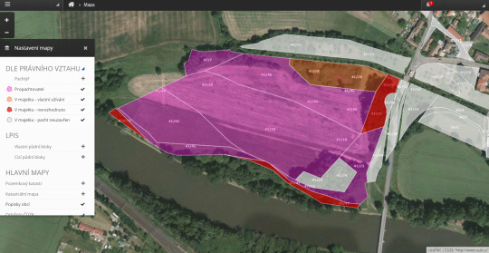
Vlastníkům zemědělské půdy jsme schopni připravit kompletní analýzu jejich vlastnictví a doporučit konkrétní kroky pro zvýšení výnosů z pachtů. Díky mnoholetým zkušenostem s katastrem nemovitostí a vlastním průzkumům trhu nabízíme také poradenství v oblasti nákup a prodej půdy a zajištění potřebné agendy.

Aplikace je určena nejen vlastníkům půdy, ale také hospodařícím zemědělcům, kterým hlídá změny ve vlastnictví půdy, automaticky vyplácí pacht, zjednodušuje směny pozemků a mnoho dalšího.
Pořádek v pachtovních smlouvách přispívá k nastavení tržní ceny pachtů a férovému jednání mezi vlastníkem a zemědělcem, což je klíčem pro zachování kvality půdy pro budoucí generace.
Více o tom, jak aplikace funguje, také na www.cleverassets.cz.
Hexagon Safety & Infrastructure Helps North Wales Police Identify Vulnerable Callers
17.8.2016 2:30 Hexagon Safety & InfrastructureNorth Wales Police has successfully implemented Hexagon Safety & Infrastructure’s Known Callers contact management module as part of its Intergraph Computer-Aided Dispatch (I/CAD) incident management system. The new module helps North Wales Police satisfy a crucial requirement of providing the ability to identify repeat and vulnerable callers at the point of contact.
Addressing caller vulnerabilities is a key requirement for North Wales Police and other forces throughout the UK, a need cited by Her Majesty’s Inspectorate of Constabulary (HMIC), which independently assesses police forces in England and Wales on how effectively they protect vulnerable people from harm and support victims. The solution also aids police force safety by automatically alerting operators to any potential risk of dispatching officers to premises where legally held firearms may be present. The new module builds upon North Wales Police’s existing I/CAD system from Hexagon, a suite of industry-leading incident management software that features complete, integrated capabilities for call handling and dispatching, field communications and more.
The new Hexagon solution improves the collection of information from the caller through a configurable workflow that supports the principle of “collect once, use many times”. It uses a specialised rules engine that supports structured dialogue and helps avoid double entry of information. It also automates the search of data already held by the force, reducing the time spent by the communications operator on basic checking of intelligence. This consistent approach provides more effective support to those in greatest need of the police’s protection and support.
Paul Shea, North Wales Police Control Room Manager, said, “Hexagon has provided North Wales Police with a solution which assists communications operators to identify caller’s vulnerabilities at the point of contact, while also providing a comprehensive history of calls. Following work by the Hexagon team to meet our organisations’ specific needs at the point of call, the solution has far exceeded our initial expectations.”
Ian Holmes, Public Safety and Security Sales Manager, Hexagon Safety & Infrastructure, said, “Hexagon is pleased to assist North Wales Police by improving call-handling performance as identified by HMIC. Building from our long-term commitment and relationship, we will continue to work in partnership together for a safer North Wales.”
The global leader in public safety and security solutions, Hexagon Safety & Infrastructure helps protect 1 in 12 people worldwide. By improving the quality, accuracy and availability of critical information, Hexagon’s integrated solutions increase public safety and security performance and productivity, while reducing the total cost of ownership for mission-critical IT investments.
Hexagon Safety & Infrastructure Helps North Wales Police Identify Vulnerable Callers
17.8.2016 2:30 Hexagon Safety & Infrastructure Hexagon solution aids police in satisfying key public and police safety requirementsHexagon Safety & Infrastructure Helps North Wales Police Identify Vulnerable Callers
17.8.2016 2:30 Hexagon Safety & Infrastructure Hexagon solution aids police in satisfying key public and police safety requirementsHexagon Safety & Infrastructure Helps North Wales Police Identify Vulnerable Callers
17.8.2016 2:30 Hexagon Safety & InfrastructureNorth Wales Police has successfully implemented Hexagon Safety & Infrastructure’s Known Callers contact management module as part of its Intergraph Computer-Aided Dispatch (I/CAD) incident management system. The new module helps North Wales Police satisfy a crucial requirement of providing the ability to identify repeat and vulnerable callers at the point of contact.
Addressing caller vulnerabilities is a key requirement for North Wales Police and other forces throughout the UK, a need cited by Her Majesty’s Inspectorate of Constabulary (HMIC), which independently assesses police forces in England and Wales on how effectively they protect vulnerable people from harm and support victims. The solution also aids police force safety by automatically alerting operators to any potential risk of dispatching officers to premises where legally held firearms may be present. The new module builds upon North Wales Police’s existing I/CAD system from Hexagon, a suite of industry-leading incident management software that features complete, integrated capabilities for call handling and dispatching, field communications and more.
The new Hexagon solution improves the collection of information from the caller through a configurable workflow that supports the principle of “collect once, use many times”. It uses a specialised rules engine that supports structured dialogue and helps avoid double entry of information. It also automates the search of data already held by the force, reducing the time spent by the communications operator on basic checking of intelligence. This consistent approach provides more effective support to those in greatest need of the police’s protection and support.
Paul Shea, North Wales Police Control Room Manager, said, “Hexagon has provided North Wales Police with a solution which assists communications operators to identify caller’s vulnerabilities at the point of contact, while also providing a comprehensive history of calls. Following work by the Hexagon team to meet our organisations’ specific needs at the point of call, the solution has far exceeded our initial expectations.”
Ian Holmes, Public Safety and Security Sales Manager, Hexagon Safety & Infrastructure, said, “Hexagon is pleased to assist North Wales Police by improving call-handling performance as identified by HMIC. Building from our long-term commitment and relationship, we will continue to work in partnership together for a safer North Wales.”
The global leader in public safety and security solutions, Hexagon Safety & Infrastructure helps protect 1 in 12 people worldwide. By improving the quality, accuracy and availability of critical information, Hexagon’s integrated solutions increase public safety and security performance and productivity, while reducing the total cost of ownership for mission-critical IT investments.
Hexagon Safety & Infrastructure Helps North Wales Police Identify Vulnerable Callers
17.8.2016 2:30 Hexagon Safety & InfrastructureNorth Wales Police has successfully implemented Hexagon Safety & Infrastructure’s Known Callers contact management module as part of its Intergraph Computer-Aided Dispatch (I/CAD) incident management system. The new module helps North Wales Police satisfy a crucial requirement of providing the ability to identify repeat and vulnerable callers at the point of contact.
Addressing caller vulnerabilities is a key requirement for North Wales Police and other forces throughout the UK, a need cited by Her Majesty’s Inspectorate of Constabulary (HMIC), which independently assesses police forces in England and Wales on how effectively they protect vulnerable people from harm and support victims. The solution also aids police force safety by automatically alerting operators to any potential risk of dispatching officers to premises where legally held firearms may be present. The new module builds upon North Wales Police’s existing I/CAD system from Hexagon, a suite of industry-leading incident management software that features complete, integrated capabilities for call handling and dispatching, field communications and more.
The new Hexagon solution improves the collection of information from the caller through a configurable workflow that supports the principle of “collect once, use many times”. It uses a specialised rules engine that supports structured dialogue and helps avoid double entry of information. It also automates the search of data already held by the force, reducing the time spent by the communications operator on basic checking of intelligence. This consistent approach provides more effective support to those in greatest need of the police’s protection and support.
Paul Shea, North Wales Police Control Room Manager, said, “Hexagon has provided North Wales Police with a solution which assists communications operators to identify caller’s vulnerabilities at the point of contact, while also providing a comprehensive history of calls. Following work by the Hexagon team to meet our organisations’ specific needs at the point of call, the solution has far exceeded our initial expectations.”
Ian Holmes, Public Safety and Security Sales Manager, Hexagon Safety & Infrastructure, said, “Hexagon is pleased to assist North Wales Police by improving call-handling performance as identified by HMIC. Building from our long-term commitment and relationship, we will continue to work in partnership together for a safer North Wales.”
The global leader in public safety and security solutions, Hexagon Safety & Infrastructure helps protect 1 in 12 people worldwide. By improving the quality, accuracy and availability of critical information, Hexagon’s integrated solutions increase public safety and security performance and productivity, while reducing the total cost of ownership for mission-critical IT investments.
Natura 2000 - Krajinný pokryv (E-shop - předpřipravená datová sada)
17.8.2016 2:00 Cenia - Katalog metadat ČR - INSPIRE Vrstva Natura 2000 je součástí služby Copernicus pro monitorování území. Obsahuje podrobné informace o využití území v chráněných oblastech soustavy Natura 2000 (spolu s 2km obalovou zónou) ve 39 evropských státech. Jedná se o vektorová data v měřítku cca 1 : 10 000, aktuálně dostupná za roky 2006 a 2012.Mapa osídlení (E-shop - předpřipravená datová sada)
17.8.2016 2:00 Cenia - Katalog metadat ČR - INSPIRE Mapa evropského osídlení je součástí služby Copernicus pro monitorování území. Jedná se o rastr vytvořený na základě družicových snímků SPOT5 a SPOT6, který zobrazuje procento zastavěného území na prostorovou jednotku. Aktuálně jsou k dispozici data za r. 2014 se 100metrovým prostorovým rozlišením a za r. 2016 s 10metrovým rozlišením.Zásady územního rozvoje - využití území - WFS
17.8.2016 2:00 Cenia - Katalog metadat ČR - INSPIRE Zásady územního rozvoje - využití území - WMSRiparian Zones (E-shop - předpřipravená datová sada)
17.8.2016 2:00 Cenia - Katalog metadat ČR - INSPIRE Riparian Zones (Břehové zóny) jsou součástí služby Copernicus pro monitorování území. Obsahuje podrobné informace o využití území v okolí vodních toků a zmapovaných zelených lineárních prvků (Green Linear Elements) ve 39 evropských státech. Jedná se o vektorová data v měřítku cca 1 : 10 000, aktuálně dostupná za období 2010 - 2013.Zásady územního rozvoje - využití území - WMS
17.8.2016 2:00 Cenia - Katalog metadat ČR - INSPIRE Zásady územního rozvoje - využití území - WMSHigh Resolution Layers 2012 (E-shop - předpřipravená datová sada)
17.8.2016 2:00 Cenia - Katalog metadat ČR - INSPIRE High Resolution Layers (HRL) jako součást služby evropského programu Copernicus pro monitorování území obsahují informace z pěti různých tématických oblastí – nepropustnost povrchu, lesy (hustota a typ lesních porostů), přírodní a polopřírodní louky (v současnosti není dostupná ke stažení a je přepracovávána), mokřady a trvalé vodní plochy. Jedná se o rastrová data o prostorovém rozlišení 20 metrů, která jsou vytvářena poloautomatickými postupy nad družicovými snímky každé 3 roky (aktuálně za r. 2012).Data vznikala řízenou klasifikací nad družicovými snímky a následnou manuální editací. Původní prostorové rozlišení je 20 metrů, validované produkty budou převzorkovány na 100metrové rozlišení. Data nebyla validována.Ministr zemědělství Marian Jurečka pracovně navštívil Státní pozemkový úřad
17.8.2016 0:00 Státní pozemkový úřad Praha, 16. srpna 2016 – Ministr zemědělství Marian Jurečka dnes pracovně navštívil ústředí Státního pozemkového úřadu (SPÚ). Zúčastnil se zde porady krajských ředitelů a vedení SPÚ.Státní pozemkový úřad zahájil 10. ročník soutěže Společné zařízení roku
17.8.2016 0:00 Státní pozemkový úřad Praha, 17. srpna 2016 – Státní pozemkový úřad dnes zahájil jubilejní ročník soutěže o nejkvalitnější realizovaná společná zařízení navrhovaná v pozemkových úpravách.Zemřel Ing. Zdeněk Konečný
16.8.2016 18:57 Zeměměřič Ing. Zdeněk Konečný zemřel 11. srpna 2016 ve věku 65 let.Oprava pádu ArcMap 10.4 a 10.4.1 při otevření mapového dokumentu
16.8.2016 14:35 ARCDATASpolečnost Esri obdržela od uživatelů chybová hlášení, že po aktualizaci na ArcGIS 10.4 nebo 10.4.1 for Desktop dochází k pádu aplikace ArcMap při otevření mapového dokumentu. Zjistilo se, že toto chování je spojeno s uložením dat v enterprise geodatabázi s MS SQL Server 2008, 2008 R2, 2012 a 2014, pokud geodatabáze obsahuje kombinaci tříd prvků s nízkou a vysokou přesností ukládání souřadnic. Uživatelé používající jiný typ databáze tímto problémem nebyli zasaženi.
Uživatelům, kteří ve své enterprise geodatabázi s MS SQL Server používají oba typy přesnosti ukládání souřadnic, proto doporučujeme instalovat opravný balíček, který je možné stáhnout ze stránek společnosti Esri. Více se o této problematice můžete dočíst v následujícím článku.
V seznamu mapových služeb obla
16.8.2016 12:00 Plzeňský kraj V seznamu mapových služeb oblasti Doprava a silniční hospodářství byl aktualizován obsah mapové služby Stavební akce na silnicích Plzeňského kraje v letech 2015 a 2016. Byly doplněny nově schválené akce z rozpočtu Plzeňského kraje.V seznamu mapových služeb obla
16.8.2016 12:00 Plzeňský kraj V seznamu mapových služeb oblasti Doprava a silniční hospodářství (http://geoportal.plzensky-kraj.cz/gs/doprava-a-silnicni-hospodastvi) byl aktualizován obsah mapové služby Stavební akce na silnicích Plzeňského kraje v letech 2015 a 2016 (http://tinyurl.com/qcozxw6). Byly doplněny nově schválené akce z rozpočtu Plzeňského kraje.Náležitosti podání
16.8.2016 10:38 ČÚZK - předpisy a opatření Přečtete si prosím, jaké jsou náležitosti podání.Náležitosti podání
16.8.2016 10:38 ČÚZK - předpisy a opatření Přečtete si prosím, jaké jsou náležitosti podání.Náležitosti podání
16.8.2016 10:38 ČÚZK /Urady/Katastralni-urady/Katastralni-urady/Katastralni-urad-pro-hlavni-mesto-Prahu/O-uradu/Aktuality/Nalezitosti-podaniNáležitosti podání
16.8.2016 10:38 ČÚZK - předpisy a opatření Přečtete si prosím, jaké jsou náležitosti podání.Náležitosti podání
16.8.2016 10:38 ČÚZK - předpisy a opatřeníPřečtete si prosím, jaké jsou náležitosti podání.
Urban Atlas 2006 (E-shop - předpřipravená datová sada)
16.8.2016 2:00 Cenia - Katalog metadat ČR - INSPIRE Urban Atlas je součástí služby Copernicus pro monitorování území. Obsahuje podrobné informace o využití území ve městech a jejich okolí a jeho změnách. Jedná se o vektorová data v měřítku cca 1 : 10 000, která jsou vytvářena nad družicovými snímky každých 6 let. Mapována jsou evropská města s více než 100 000 obyvateli.Využití území odvozené ze ZÚR JČK - WMS
16.8.2016 2:00 Cenia - Katalog metadat ČR - INSPIRE Využití území na základě dat ZÚR Jihočeského krajeVyužití území odvozené ze ZÚR JČK - data
16.8.2016 2:00 Cenia - Katalog metadat ČR - INSPIRE Souhrn datových sad pro službu Využití území odvozené ze ZÚR JČK. Využití vrstvy: Dopravní a technická infrastruktura a logistika, Dopravní a technická infrastruktura a logistika - bod, Ostatní využití, Rozvojové plochyVyužití území odvozené ze ZÚR JČK - Dopravní a technická infrastruktura a logistika - bod
16.8.2016 2:00 Cenia - Katalog metadat ČR - INSPIRE 4_3_4_Ostatní technická infrastrukturaINSPIRE téma Parcely (CP)
16.8.2016 2:00 Cenia - Katalog metadat ČR - INSPIRE Data odpovídají směrnici INSPIRE pro téma katastrální parcely (CP). Vychází z katastrální mapy, která je závazným státním mapovým dílem velkého měřítka, obsahuje body polohového bodového pole, polohopis a popis a může mít formu digitální mapy, analogové mapy nebo digitalizované mapy. Data publikovaná v rámci INSPIRE obsahují pouze katastrální území (pro celou Českou Republiku) a parcely a jejich hranice z území, kde je digitální mapa (k 15. 08. 2016 je to 84,97% území České republiky, t.j. 67 011,84km2). Více katastrální zákon 256/2013 Sb., katastrální vyhláška č.357/2013 Sb. v platném znění a INSPIRE Data Specification on Cadastral Parcels v 3.0.1.Využití území odvozené ze ZÚR JČK - Ostatní využití
16.8.2016 2:00 Cenia - Katalog metadat ČR - INSPIRE 6_3_Přírodní oblasti bez jiného ekonomického využitíUrban Atlas 2012 (E-shop - předpřipravená datová sada)
16.8.2016 2:00 Cenia - Katalog metadat ČR - INSPIRE Urban Atlas je součástí služby Copernicus pro monitorování území. Obsahuje podrobné informace o využití území ve městech a jejich okolí a jeho změnách. Jedná se o vektorová data v měřítku cca 1 : 10 000, která jsou vytvářena nad družicovými snímky každých 6 let. Mapována jsou evropská města s více než 100 000 obyvateli.Využití území odvozené ze ZÚR JČK - Rozvojové plochy
16.8.2016 2:00 Cenia - Katalog metadat ČR - INSPIRE 1_3_3_Ostatní těžba a dobývání 2_3_Lehký průmysl 2_4_1_Jaderná energetika 2_4_4_Výroba energie z obnovitelných zdrojů 3_4_Kulturní a rekreační zařízení 6_1_Přestavbová územíINSPIRE téma Adresy (AD)
16.8.2016 2:00 Cenia - Katalog metadat ČR - INSPIRE Data odpovídají směrnici INSPIRE pro téma adresy (AD). Vychází především z projektu RÚIAN (Registr územní identifikace, adres a nemovitostí), který je součástí základních registrů České Republiky a obsahuje informace o územní identifikaci, adresách a nemovitostech. Data publikovaná v rámci INSPIRE obsahují pouze adresní místa a jejich komponenty, kterými jsou stát, obec, část obce, městský obvod v Praze (MOP), městký obvod/městská část (MO/MČ), ulice a pošta a to na území celé České Republiky. Obsahují rozvněž geometrii, která určuje definiční bod adresního místa. V datové sadě nění uvedeno 2,61%, t.j. 75696 adresních míst (k 15. 08. 2016), protože neobsahují definiční bod, podle kterého by je bylo možné prostorově určit. Více v zákoně č. 111/2009 Sb., o základních registrech a ve vyhlášce č. 359/2011 Sb., o základním registru územní identifikace, adres a nemovitostí v platných zněních a INSPIRE Data Specification on Addresses v 3.0.1 z 26.4.2010.High Resolution Layers 2012
16.8.2016 2:00 Cenia - Katalog metadat ČR - INSPIRE High Resolution Layers (HRL) jako součást služby evropského programu Copernicus pro monitorování území obsahují informace z pěti různých tématických oblastí – nepropustnost povrchu, lesy (hustota a typ lesních porostů), přírodní a polopřírodní louky (v současnosti není dostupná ke stažení a je přepracovávána), mokřady a trvalé vodní plochy. Jedná se o rastrová data o prostorovém rozlišení 20 metrů, která jsou vytvářena poloautomatickými postupy nad družicovými snímky každé 3 roky (aktuálně za r. 2012).Data vznikala řízenou klasifikací nad družicovými snímky a následnou manuální editací. Původní prostorové rozlišení je 20 metrů, validované produkty budou převzorkovány na 100metrové rozlišení. Data nebyla validována.Využití území odvozené ze ZÚR JČK - Dopravní a technická infrastruktura a logistika
16.8.2016 2:00 Cenia - Katalog metadat ČR - INSPIRE 4_1_1_Silniční dopravní infrastruktura4_1_2_Železniční dopravní infrastruktura4_1_3_Letecká dopravní infrastruktura4_1_4_Vodní dopravní infrastruktura4_1_5_Ostatní dopravní infrastruktura4_3_1_Elektrické sítě, zásobování plynem a teplem4_3_2_Vodovody a kanalizaceVyužití území odvozené ze ZÚR JČK - WFS
16.8.2016 2:00 Cenia - Katalog metadat ČR - INSPIRE Využití území na základě dat ZÚR Jihočeského krajeINSPIRE téma Budovy (BU)
16.8.2016 2:00 Cenia - Katalog metadat ČR - INSPIRE Data odpovídají směrnici INSPIRE pro téma budovy (BU). Data pochází částečně z projektu RÚIAN (Registr územní identifikace, adres a nemovitostí), který je součástí základních registrů České Republiky a obsahuje informace o územní identifikaci, adresách a nemovitostech, a částečně z ISKN (Informační systém katastru nemovistostí). Zdrojem informací o budovách v ISKN je objekt Stavba, v RÚIAN je to Stavební objekt. Většina Staveb je zároveň Stavebními objekty, ale jsou případy, kdy tomu tak není. Kromě Budov datová sada obsahuje i části budov, které jsou pro potřeby INSPIRE vyjádřeny vchody z RÚIAN. Vchody obsahují informace o počtu podlaží, technickoekonomických atributech apod. Datová sada pokrývá celé území české republiky. V datové sadě není uvedeno 2,13%, t.j. 89339 budov (k 15. 08. 2016), protože neobsahují definiční bod ani polygon. Více v zákoně č. 111/2009 Sb., o základních registrech, ve vyhlášce č. 359/2011 Sb., o základním registru územní identifikace, adres a nemovitostí v platných zněních, v zákoně 256/2013 Sb., o katastru nemovitostí, v katastrální vyhlášce č. 357/2013 Sb. v platném znění a INSPIRE Data Specification on Buildings v 3.0 z 13.12.2013.Referent/referentka odboru ICT (asistent/ka)
16.8.2016 0:00 Státní pozemkový úřad Státní pozemkový úřad přijme zaměstnance za pozici referent/referentka odboru ICT (asistent/ka).Oznámení o vyhlášení výběrového řízení na služební místo rada/odborný rada oddělení podpůrných činností, odbor metodiky a řízení pozemkových úprav
16.8.2016 0:00 Státní pozemkový úřad Ústřední ředitelka Státního pozemkového úřadu, jako služební orgán příslušný podle § 10 odst. 1 písm. f) zákona č. 234/2014 Sb., o státní službě (dále jen „zákon“), vyhlašuje výběrové řízení.Oznámení o vyhlášení výběrového řízení na služební místo vrchní referent/rada, oddělení pozemkových úprav, Krajský pozemkový úřad pro Ústecký kraj
16.8.2016 0:00 Státní pozemkový úřad Ústřední ředitelka Státního pozemkového úřadu, jako služební orgán příslušný podle § 10 odst. 1 písm. f) zákona č. 234/2014 Sb., o státní službě (dále jen „zákon“), vyhlašuje výběrové řízení.20160815Odborný referent oddělení právních vztahů k nemovitostem-KP Kolín
15.8.2016 15:42 ČÚZK /Urady/Katastralni-urady/Katastralni-urady/Katastralni-urad-pro-Stredocesky-kraj/Katastralni-pracoviste/KP-Kolin/O-uradu/Aktuality/20152509-Oznameni-na-reditele-PZ-(4)20160815Odborný referent oddělení právních vztahů k nemovitostem-KP Kolín
15.8.2016 15:42 ČÚZK - předpisy a opatření Na úřední elektronické desce Katastrálního úřadu pro Středočeský kraj, v sekci "Oznámení a jiná úřední sdělení" bylo vystaveno "Oznámení o vyhlášení výběrového řízení na služební místo Odborný referent oddělení právních vztahů k nemovitostem pro Katastrální pracoviště Kolín"20160815-Odborný referent oddělení právních vztahů k nemovitostem-KP Kolín
15.8.2016 15:39 ČÚZK /Urady/Katastralni-urady/Katastralni-urady/Katastralni-urad-pro-Stredocesky-kraj/O-uradu/Aktuality/20152509-Oznameni-na-reditele-TS,-PZ-a-PV-(2)20160815-Odborný referent oddělení právních vztahů k nemovitostem-KP Kolín
15.8.2016 15:39 ČÚZK - předpisy a opatření V části "Úřední deska", v sekci "Oznámení a jiná úřední sdělení" bylo vystaveno "Oznámení o vyhlášení výběrového řízení na služební místo Odborný referent oddělení právních vztahů k nemovitostem pro Katastrální pracoviště Kolín"Odborný referent oddělení právních vztahů k nemovitostem (2)
15.8.2016 15:36 ČÚZK /Urady/Katastralni-urady/Katastralni-urady/Katastralni-urad-pro-Stredocesky-kraj/Uredni-deska/Oznameni-a-jina-uredni-sdeleni/Volna-mista/Odborny-referent-oddeleni-pravnich-vztahu-k-ne-(2)Odborný referent oddělení právních vztahů k nemovitostem
15.8.2016 15:36 ČÚZK /Urady/Katastralni-urady/Katastralni-urady/Katastralni-urad-pro-Stredocesky-kraj/Uredni-deska/Oznameni-a-jina-uredni-sdeleni/Volna-mista/Odborny-referent-oddeleni-pravnich-vztahu-k-ne-(2)Odborný referent oddělení právních vztahů k nemovitostem (2)
15.8.2016 15:36 ČÚZK - volná místa Katastrální úřad pro Středočeský kraj, Katastrální pracoviště Kolín vypisuje výběrové řízení na místo Odborný referent oddělení právních vztahů k nemovitostem (2)Odborný referent oddělení právních vztahů k nemovitostem
15.8.2016 15:36 ČÚZK - volná místa Katastrální úřad pro Středočeský kraj, Katastrální pracoviště Kolín vypisuje výběrové řízení na místo Odborný referent oddělení právních vztahů k nemovitostemOdborný referent oddělení právních vztahů k nemovitostem
15.8.2016 15:36 ČÚZK - předpisy a opatření Katastrální úřad pro Středočeský kraj Katastrální pracoviště Kolínvypisuje výběrové řízení na místo Odborný referent oddělení právních vztahů k nemovitostem
Odborný referent oddělení právních vztahů k nemovitostem
Odborný referent oddělení právních vztahů k nemovitostem (2)
15.8.2016 15:36 ČÚZK - předpisy a opatření Katastrální úřad pro Středočeský kraj Katastrální pracoviště Kolínvypisuje výběrové řízení na místo Odborný referent oddělení právních vztahů k nemovitostem
Odborný referent oddělení právních vztahů k nemovitostem
Změna mapových služeb
15.8.2016 14:59 Geoportál PrahaUpozorňujeme uživatele mapových služeb Digitální technické mapy Prahy a podkladových map na změnu adres služeb.
odborný referent/vrchní referent v oddělení aktualizace KN č. 2 na KP Znojmo
15.8.2016 14:47 ČÚZK /Urady/Katastralni-urady/Katastralni-urady/Katastralni-urad-pro-Jihomoravsky-kraj/Uredni-deska/Oznameni-a-jina-uredni-sdeleni/Volna-mista/odborny-referent-vrchni-referent-v-oddeleni-ak-(5)odborný referent/vrchní referent v oddělení aktualizace KN č. 2 na KP Znojmo
15.8.2016 14:47 ČÚZK - volná místa Katastrální úřad pro Jihomoravský kraj, Katastrální pracoviště Znojmo vypisuje výběrové řízení na místo odborný referent/vrchní referent v oddělení aktualizace KN č. 2 na KP Znojmoodborný referent/vrchní referent v oddělení aktualizace KN č. 2 na KP Znojmo
15.8.2016 14:47 ČÚZK - předpisy a opatření Katastrální úřad pro Jihomoravský kraj Katastrální pracoviště Znojmovypisuje výběrové řízení na místo
odborný referent/vrchní referent v oddělení aktualizace KN č. 2 na KP Znojmo
odborný referent v právním oddělení č. 2 na KP Brno-město
15.8.2016 14:42 ČÚZK /Urady/Katastralni-urady/Katastralni-urady/Katastralni-urad-pro-Jihomoravsky-kraj/Uredni-deska/Oznameni-a-jina-uredni-sdeleni/Volna-mista/odborny-referent-v-pravnim-oddeleni-c-2-na-KP-Brnoodborný referent v právním oddělení č. 2 na KP Brno-město
15.8.2016 14:42 ČÚZK - předpisy a opatření Katastrální úřad pro Jihomoravský kraj Katastrální pracoviště Brno-městovypisuje výběrové řízení na místo
odborný referent v právním oddělení č. 2 na KP Brno-město
odborný referent v právním oddělení č. 2 na KP Brno-město
15.8.2016 14:42 ČÚZK - volná místa Katastrální úřad pro Jihomoravský kraj, Katastrální pracoviště Brno-město vypisuje výběrové řízení na místo odborný referent v právním oddělení č. 2 na KP Brno-městoodborný referent v právním oddělení na KP Brno-venkov
15.8.2016 14:36 ČÚZK - volná místa Katastrální úřad pro Jihomoravský kraj, Katastrální pracoviště Brno-venkov vypisuje výběrové řízení na místo odborný referent v právním oddělení na KP Brno-venkovodborný referent v právním oddělení na KP Brno-venkov
15.8.2016 14:36 ČÚZK - předpisy a opatření Katastrální úřad pro Jihomoravský kraj Katastrální pracoviště Brno-venkovvypisuje výběrové řízení na místo
odborný referent v právním oddělení na KP Brno-venkov