


zprávy
zdroje zpráv:Fortem Technologies and IDGA Announce Webinar: Countering Drones Used by Criminals, Terrorists, and Bad State Actors
3.6.2021 17:20 GISCafe.com Webcasts-Webinars Pleasant Grove, Utah, June 03, 2021 (GLOBE NEWSWIRE) -- Fortem Technologies, the leader in airspace security and defense for detecting and …Sea Level Rise Data for every address in the USA is now in the HazardHub API
3.6.2021 17:20 GISCafe.com Webcasts-Webinars The HazardHub data will report the impact of one-foot increments - up to 10 feet - for any location in the US. Sea Level Rise data is fully …DeepMap Announces RoadMemory, a Highly-Scalable and Economical Mapping Service, Enabling Hands-Off Driving Everywhere
3.6.2021 17:20 GISCafe.com Webcasts-Webinars - New Service Provides Automakers with Fully-Crowdsourced, Automated, and Fresh Maps for Most Autonomous Driving Scenarios, Including Highways and …Next Edition of Commercial UAV Expo Europe to take place with Amsterdam Drone Week and EASA in Amsterdam 18-20 January 2022
3.6.2021 17:20 GISCafe.com Webcasts-Webinars Organizers of Commercial UAV Expo Europe have announced that the next edition of the event will take place with Amsterdam Drone Week (ADW) and EASA …DGT Associates, Leading Surveying, Engineering, and Subsurface Utility Mapping Firm in New England, Turns 25 and Completes 6,130 Projects
3.6.2021 15:58 GISCafe.com Webcasts-Webinars BOSTON — (BUSINESS WIRE) — June 3, 2021 —As one of New England’s prominent surveying, engineering, and subsurface utility …
Trimble Expands its Geospatial Automated Monitoring Portfolio with Worldsensing Geotechnical IoT Solutions
3.6.2021 15:58 GISCafe.com Webcasts-Webinars New Products Enable Trimble's Global Distribution Channel to Provide a Complete, Turn-Key Automated Monitoring System for Infrastructure and …Hexagon Introduces HxGN Mass Transit to Improve Public Transportation Operations
3.6.2021 15:58 GISCafe.com Webcasts-Webinars System optimizes field operations and monitoring of assets through 3D, AI and mobile capabilitiesHUNTSVILLE, Ala., June 3, 2021 — (PRNewswire) …
20210603 - zablokovaná fronta z ISÚI do RÚIAN
3.6.2021 14:41 ČÚZK - předpisy a opatření Důležité sdělení: V pondělí 31. 5. 2021 došlo k zablokování komunikační fronty z ISÚI do RÚIAN. Společně se Správou základních registrů intenzivně pracujeme na odstranění technických problémů. V důsledku zablokované fronty nedochází k přenosu změn z ISÚI do RÚIAN/VDP. Omlouváme se za případné komplikace.20210603 - zablokovaná fronta z ISÚI do RÚIAN
3.6.2021 14:41 ČÚZK /Uvod/Produkty-a-sluzby/RUIAN/RUIAN-novinky/2021/20210603-zablokovana-fronta-z-ISUI-do-RUIANGoing green? Look to EU Space!
3.6.2021 14:26 European GNSS Agency
From the air we breathe to the water we drink and the land we grow our food on, our ecological footprint and means to minimise it are more in the focus than ever. Innovative technological solutions, including space-based applications, can help to prevent pollution and reduce its negative impacts: from agriculture to transport. To mark the European Green Week 2021, which runs from 31 May to 4 June, we look at some of the contributions that space is making to a greener future.
This year, the European Green Week is dedicated to the ‘zero pollution ambition’ and looks at relevant European Green Deal initiatives, such as the climate initiatives, the upcoming Chemicals Strategy and #FitFor55 as well as initiatives in the fields of energy, industry, mobility, agriculture, fisheries, health and biodiversity. In all of these areas, EU Space is making a positive contribution.
Synergies are key
While both Copernicus and EGNSS (Galileo and EGNOS) are making a major contribution to reducing pollution individually, it is by tapping into synergies between these components of the EU Space Programme that we can make the most significant impact on the green transition.
Read this: Space synergies serving the environment
In agriculture, for example, farmers can combine information on crop health and soil moisture provided by Copernicus with positioning services from Galileo and EGNOS in precision agriculture applications to use water, fertilizers and other resources where they are needed most. It is estimated that until 2025, the combination of EGNSS and Earth Observation services can help save 1.5 million tonnes of fertiliser (up to 20% in savings for users) and 4,500 tonnes of pesticides (up to 25% in savings for users) in Europe.
An example of where EO and EGNSS are delivering environmental benefits is the FaST digital service platform, promoting the generation and re-use of solutions for sustainable and competitive agriculture. Meanwhile, the EGNSS4CAP app digitises the Common Agricultural Policy (CAP) reporting procedures. For example, automatic monitoring procedures employ services from both, Copernicus and Galileo and thus reduce the number of On the Spot Checks (OTSC).
Space and the Green Deal
The EU is tackling the environmental challenges that Europe faces with the implementation of the Green Deal, a guiding document that paves the way towards a sustainable European economy. The EU Green Deal sets concrete targets not only to protect the environment but also to build a greener economy that manages the Earth’s resources in a sustainable way. Space is a key element of this initiative, providing services that help Europe reduce and adapt to climate change and mitigate its effects.
Watch this: EUSPA Space for our Planet Challenge
Real-time and forecast information provided by Copernicus and precise positioning and navigation powered by Galileo and EGNOS, make it possible to predict and optimize traffic, enable efficient placement and maintenance of renewable energy infrastructure, support smart electricity grids, improve urban planning, and support the sharing economy. In sectors like transportation, until 2025, the EU Space Programme will help to save 15 million tonnes of CO₂ emissions (equal to 3 Kg of CO₂ per year saved by every EU citizen) and 3.5 billion litres of fuel (equal to 4.5 years’ worth of total EU demand for refined petroleum) in Europe.
The EU Space Programme directly supports over 20 Green Deal actions and has already helped to drastically bring down CO2 emissions and greatly reduce the EU’s carbon footprint. By supporting solutions and applications in the sectors mentioned above, along with countless other services and applications, space will play an increasingly important role in helping the EU to achieve its sustainability goals, building a green and prosperous future for Europe.
Media note: This feature can be republished without charge provided the European Union Agency for the Space Programme (EUSPA) is acknowledged as the source at the top or the bottom of the story. You must request permission before you use any of the photographs on the site. If you republish, we would be grateful if you could link back to the EUSPA website (http://www.euspa.europa.eu).
Galileo satellites’ last step before launch
3.6.2021 13:04 ESA Navigation
Europe’s Galileo satellite navigation constellation is set to grow. Later this year the first two out of 12 ‘Batch 3’ Galileo satellites will be launched by Soyuz from French Guiana. Their last step on the way to launch is situated beside sand dunes on the Dutch coast: the ESTEC Test Centre, which is Europe’s largest satellite test facility.
Referent/ka zeměměřictví a katastru nemovitostí
3.6.2021 11:12 Zeměměřický úřad Zeměměřický úřadvypisuje výběrové řízení na místo
Referent/ka zeměměřictví a katastru nemovitostí
Referent/ka zeměměřictví a katastru nemovitostí
3.6.2021 11:12 ČÚZK - předpisy a opatření Zeměměřický úřadvypisuje výběrové řízení na místo
Referent/ka zeměměřictví a katastru nemovitostí
Referent/ka zeměměřictví a katastru nemovitostí
3.6.2021 11:12 ČÚZK /Urady/Zememericky-urad/Uredni-deska/Oznameni-a-jina-uredni-sdeleni/Volna-mista/Referent-ka-zememerictvi-a-katastru-nemovitostiReferent/ka zeměměřictví a katastru nemovitostí
3.6.2021 11:12 ČÚZK - volná místa Zeměměřický úřad vypisuje výběrové řízení na místo Referent/ka zeměměřictví a katastru nemovitostí20210603_Rada / odborný rada oddělení právních vztahů k nemovitostem
3.6.2021 10:52 ČÚZK /Urady/Katastralni-urady/Katastralni-urady/Katastralni-urad-pro-Stredocesky-kraj/Katastralni-pracoviste/KP-Kladno/O-uradu/Aktuality/20210113_odborny-rada,-reditel-Katastralniho-p-(2)20210603_Rada / odborný rada oddělení právních vztahů k nemovitostem
3.6.2021 10:52 ČÚZK - předpisy a opatření Katastrální úřad pro Středočeský kraj - Katastrální pracoviště Kladno Vyhlášení výběrového řízení: Rada / odborný rada oddělení právních vztahů k nemovitostem V části "Úřední deska", v sekci "Oznámení a jiná úřední sdělení" bylo vystaveno "Oznámení o vyhlášení výběrového řízení na obsazení služebního místa Rada / odborný rada oddělení právních vztahů k nemovitostem"Rada / odborný rada oddělení právních vztahů k nemovitostem
3.6.2021 10:51 ČÚZK - volná místa Katastrální úřad pro Středočeský kraj - Katastrální pracoviště Kladno vypisuje výběrové řízení na místo Rada / odborný rada oddělení právních vztahů k nemovitostemRada / odborný rada oddělení právních vztahů k nemovitostem
3.6.2021 10:51 ČÚZK - předpisy a opatření Katastrální úřad pro Středočeský kraj - Katastrální pracoviště Kladnovypisuje výběrové řízení na místo Rada / odborný rada oddělení právních vztahů k nemovitostem
Rada / odborný rada oddělení právních vztahů k nemovitostem
Nahlížení do KN
3.6.2021 10:30 ČÚZK - aktuality v resortu Ve věci připravovaných úprav aplikace Nahlížení do KN byla vydána tisková zpráva Ministerstva zemědělství.Nahlížení do KN
3.6.2021 10:30 ČÚZK - předpisy a opatření Český úřad zeměměřický a katastrální zveřejnil novou aktualitu: Ve věci připravovaných úprav aplikace Nahlížení do KN byla vydána tisková zpráva Ministerstva zemědělství.Webinář: Rozšíření a automatizace ArcGIS Pro
3.6.2021 9:26 ARCDATAV úterý 8. června 2021 si vás dovolujeme pozvat na poslední díl ze série webových seminářů o ArcGIS Pro. Tentokrát se zaměříme na to, jak zjednodušit rutinní pracovní postupy a ukážeme si i některé nadstavby k ArcGIS Pro. Podíváme se na práci s nástroji v prostředí ModelBuilder i na tvorbu úloh (tasks) a ukážeme si jejich praktické využití. Seznámíme se také se skriptovacím jazykem Python, kde si nejprve ukážeme základní možnosti a pak i jeho použití v ArcGIS Pro.
Pro sledování semináře není zapotřebí instalovat žádný software, ani doplněk prohlížeče, stačí se pouze zaregistrovat na stránce webináře. Registrace i účast na semináři jsou zdarma.
Pokud vás témata jednotlivých webových seminářů zajímají, neváhejte se ptát a diskutovat s námi na Esri Community. Naleznete zde nejen přehled všech námi chystaných i proběhlých akcí, ale především odpovědi na otázky, které během jednotlivých webových seminářů padly.

Co jste zažívali během Covidu?
3.6.2021 8:57 GISportal.cz
Kolegové z Salzburské geoinformatiky nás požádali o sdílení jejich dotazníku ohledně toho, jak lidé zažívali pandemii covid-19. Pokud byste měli zájem se do jejich výzkumu zapojit – jedná se o jednoduchý Survey123 dotazník, budeme rádi. Dotazník naleznete na tomto odkaze.
The post Co jste zažívali během Covidu? appeared first on GISportal.cz.
New Interactive App Visualizes 14 Months of Unemployment Data by State, County
2.6.2021 17:45 GISCafe.com Webcasts-Webinars REDLANDS, Calif. — (BUSINESS WIRE) — June 2, 2021 —Esri, the global leader in location intelligence, announced today that …
U.S. Autonomous Drone Maker Skydio Announces the General Availability of Skydio 3D Scan and Partners With Photogrammetry Leader Bentley Systems
2.6.2021 17:45 GISCafe.com Webcasts-Webinars Skydio 3D Scan, the first-of-its-kind adaptive mapping software, automates data capture with drones to open a new era of autonomous inspection …Kittyhawk.io Is Now Known As Aloft
2.6.2021 17:45 GISCafe.com Webcasts-Webinars SAN FRANCISCO — (BUSINESS WIRE) — June 2, 2021 —Kittyhawk, the market leader in drone airspace systems & UTM technologies has …
Chooch AI Integrates Synthetic Data Generation to Radically Accelerate Computer Vision Deployment
2.6.2021 17:45 GISCafe.com Webcasts-Webinars SAN MATEO, Calif., June 02, 2021 (GLOBE NEWSWIRE) -- Chooch AI, the leading computer vision AI platform, today announced artificial intelligence …Denco 9-1-1 Brings Indoor Maps to Schools, Providing 9-1-1 Actionable Location Information
2.6.2021 16:19 GISCafe.com Webcasts-Webinars Addressing Challenges of Locating 9-1-1 Indoor CallersST. CLOUD, Minn., June 2, 2021 — (PRNewswire) —
ST. CLOUD, Minn., June 2, 2021 …
AUVSI and SAE International Announce Keynote Speakers for Business of Automated Mobility Forum
2.6.2021 16:19 GISCafe.com Webcasts-Webinars From Drone Delivery to Driverless Cars, Industry Experts to Share Insights on the Opportunities and Challenges of Automated MobilityWARRENDALE, Pa., …
rada/odborný rada – vedoucí oddělení metodiky a kontroly
2.6.2021 14:20 ČÚZK - předpisy a opatření Katastrální úřad pro hlavní město Prahuvypisuje výběrové řízení na místo
rada/odborný rada – vedoucí oddělení metodiky a kontroly
rada/odborný rada – vedoucí oddělení metodiky a kontroly
2.6.2021 14:20 ČÚZK /Urady/Katastralni-urady/Katastralni-urady/Katastralni-urad-pro-hlavni-mesto-Prahu/Uredni-deska/Oznameni-a-jina-uredni-sdeleni/Volna-mista/DMS/rada-odborny-rada-–-vedouci-oddeleni-metodiky-a-korada/odborný rada – vedoucí oddělení metodiky a kontroly
2.6.2021 14:20 ČÚZK - volná místa Katastrální úřad pro hlavní město Prahu vypisuje výběrové řízení na místo rada/odborný rada – vedoucí oddělení metodiky a kontroly20210602 - Upozornění uživatelům VFR
2.6.2021 13:43 ČÚZK /Uvod/Produkty-a-sluzby/RUIAN/2-Poskytovani-udaju-RUIAN-ISUI-VDP/Vymenny-format-RUIAN/Archiv-novinek-VFR/20210602-Upozorneni-uzivatelum-VFR20210602 - Upozornění uživatelům VFR
2.6.2021 13:43 ČÚZK - předpisy a opatření Upozornění uživatelům VFR: Současné stavové (měsíční) soubory VFR za květen 2021 byly vygenerovány o den později, mají tedy označení 20210601_*, ale obsahově jsou se stavem dat k 31. 5. 2021. Soubory jsou dostupné také ve druhé totožné sadě pod názvem 20210531_*.Zveřejněno: 2. 6. 2021
EDITAČNÍ MAPA - SPORTOVIŠTĚ - II. ETAPA
2.6.2021 9:00 Středočeský kraj Byla oficiálně spuštěna editační mapa Pasportizace sportovišť - II. etapa. Cílem pasportizace sportovišť je zmapovat, kde a v jakém stavu se nachází sportoviště ve Středočeském kraji. Získaná data budou sloužit k efektivnějšímu zacílení krajské podpory. Editační mapa Veřejná editace je určena primárně pro správce sportovišť, starosty středočeských měst a obcí, zástupce sportovních svazů atd. Na aktualizaci se může podílet i veřejnost. Při I. etapě se díky respondentům podařilo zmapovat přes 900 sportovišť, vlastními silami se nasbíralo dalších 900 objektů. Novinkou oproti I. etapě je, že respondenti mají kvalitnější podkladové mapy, vidí sběr dat online a v jakém stavu zpracování se data nachází. Stav zpracování vyhodnocuje pověřený pracovník oddělení školení a mládeže. Veřejná editační mapa ZDE. Projekt je vlastní iniciativou Středočeského kraje. Aplikaci připravil Odbor Informatiky / GIS ve spolupráci s Oddělením mládeže a sportu.Omezení provozu Pobočky Beroun
2.6.2021 0:00 Státní pozemkový úřad Dovolujeme si vás informovat, že dne 4.6.2021 od 8. 00 hod. do 16.30 hod. bude omezen provoz na Pobočce Beroun z důvodu přerušení dodávky elektrické energie. Provoz podatelny bude zajištěn. V případě potřeby je k dispozici kontaktní telefon +420 606 668 879. Na e-mailové zprávy bude reagováno následující pracovní den.Za případné komplikace se omlouváme a děkujeme za pochopení.
Prodloužení mimořádného stavu na Univerzitě Karlově [Knihovna geografie, byTopic]
2.6.2021 0:00 Katedra aplikované geoinformatiky a kartografie Přf UKCATALYST Collaborates with Amazon Web Services to Deliver Geospatial Insights to Decision Makers
1.6.2021 17:21 GISCafe.com Webcasts-Webinars MARKHAM, ON, June 1, 2021 — (PRNewswire) — CATALYST, a PCI Geomatics brand, is collaborating with Amazon Web Services (AWS) to …rada/odborný rada – vedoucí samostatného oddělení ostatních řízení
1.6.2021 16:32 ČÚZK /Urady/Katastralni-urady/Katastralni-urady/Katastralni-urad-pro-hlavni-mesto-Prahu/Uredni-deska/Oznameni-a-jina-uredni-sdeleni/Volna-mista/DMS/rada-odborny-rada-–-vedouci-samostatneho-oddelenirada/odborný rada – vedoucí samostatného oddělení ostatních řízení
1.6.2021 16:32 ČÚZK - předpisy a opatření Katastrální úřad pro hlavní město Prahu - Katastrální pracoviště Prahavypisuje výběrové řízení na místo
rada/odborný rada – vedoucí samostatného oddělení ostatních řízení
rada/odborný rada – vedoucí samostatného oddělení ostatních řízení
1.6.2021 16:32 ČÚZK - volná místa Katastrální úřad pro hlavní město Prahu - Katastrální pracoviště Praha vypisuje výběrové řízení na místo rada/odborný rada – vedoucí samostatného oddělení ostatních řízeníMulti-Generational Demand: US Home Prices Post Third Month of Double-Digit Growth in April, CoreLogic Reports
1.6.2021 16:24 GISCafe.com Webcasts-Webinars CoreLogic Home Price Index recorded a 13% annual gain, the highest since February 2006Limited inventories discourage potential sellers, further …
Due to Overwhelming Demand, Velodyne Lidar LIVE! Adds New Host and Episodes
1.6.2021 16:24 GISCafe.com Webcasts-Webinars Upcoming Episodes Examine What’s Happening in Autonomous Solutions to Shape a Safer, More Intelligent FutureSAN JOSE, Calif. — (BUSINESS …
Climate Change-Influenced Hurricane Season Could Threaten an Estimated 8 Million Homes With Storm Surge in 2021 According to CoreLogic
1.6.2021 16:24 GISCafe.com Webcasts-Webinars The New York and Miami metro areas top the list with most homes at risk in the face of rising sea levelsIRVINE, Calif. — (BUSINESS WIRE) …
DRONEDEK Delivering on Promise of Smart Mailbox
1.6.2021 16:24 GISCafe.com Webcasts-Webinars Summer demonstration projects scheduled; first prototype available nowINDIANAPOLIS, June 1, 2021 — (PRNewswire) — DRONEDEK Corp., …
WSDP na zkoušku
1.6.2021 15:18 Dálkový přístup k údajům KN ČR Vážení uživatelé webových služeb,dnes 1.6.2021 byl obnoven provoz webových služeb dálkového přístupu na zkoušku.
Nově prostředí obsahuje data z celého katastrálního pracoviště Prachatice. Podrobněji zde: https://www.cuzk.cz/Katastr-nemovitosti/Poskytovani-udaju-z-KN/Dalkovy-pristup/Webove-sluzby-DP-na-zkousku.aspx
V provozu jsou verze služeb 2.8 a 2.9.
Současně informujeme, že konec provozu webových služeb verze 2.8 se předpokládá v listopadu 2021, o přesném termínu budete informováni.
Omlouváme se za komplikace a děkujeme za pochopení.
WSDP na zkoušku
1.6.2021 15:18 ČÚZK - předpisy a opatření Vážení uživatelé webových služeb,dnes 1.6.2021 byl obnoven provoz webových služeb dálkového přístupu na zkoušku.
Nově prostředí obsahuje data z celého katastrálního pracoviště Prachatice. Podrobněji zde: https://www.cuzk.cz/Katastr-nemovitosti/Poskytovani-udaju-z-KN/Dalkovy-pristup/Webove-sluzby-DP-na-zkousku.aspx
V provozu jsou verze služeb 2.8 a 2.9.
Současně informujeme, že konec provozu webových služeb verze 2.8 se předpokládá v listopadu 2021, o přesném termínu budete informováni.
Omlouváme se za komplikace a děkujeme za pochopení.
výběrové řízení na KP Pelhřimov
1.6.2021 14:51 ČÚZK - předpisy a opatření Katastrální úřad pro Vysočinu zveřejnil novou aktualitu: Oznámení o vyhlášení výběrového řízení na služební místo vrchní referent/rada v oddělení dokumentace KN Katastrálního pracoviště Pelhřimov.výběrové řízení na KP Pelhřimov
1.6.2021 14:51 ČÚZK /Urady/Katastralni-urady/Katastralni-urady/Katastralni-urad-pro-Vysocinu/O-uradu/Aktuality/vyberove-rizeni-na-KP-PelhrimovOznámení o vyhlášení výběrového řízení na služební místo
1.6.2021 14:40 ČÚZK - předpisy a opatření Katastrální úřad pro Vysočinu Katastrální pracoviště Pelhřimovvypisuje výběrové řízení na místo
Oznámení o vyhlášení výběrového řízení na služební místo
Oznámení o vyhlášení výběrového řízení na služební místo
1.6.2021 14:40 ČÚZK /Urady/Katastralni-urady/Katastralni-urady/Katastralni-urad-pro-Vysocinu/Uredni-deska/Oznameni-a-jina-uredni-sdeleni/Volna-mista/DMS/Oznameni-o-vyhlaseni-vyberoveho-rizeni-na-sluzebniOznámení o vyhlášení výběrového řízení na služební místo
1.6.2021 14:40 ČÚZK - volná místa Katastrální úřad pro Vysočinu Katastrální pracoviště Pelhřimov vypisuje výběrové řízení na místo Oznámení o vyhlášení výběrového řízení na služební místoOdborný referent/vrchní referent personálního oddělení v kanceláři ředitele katastrálního úřadu na K
1.6.2021 13:50 ČÚZK - předpisy a opatření Katastrální úřad pro Jihomoravský kraj kancelář úřaduvypisuje výběrové řízení na místo
Odborný referent/vrchní referent personálního oddělení v kanceláři ředitele katastrálního úřadu na Katastrálním úřadu pro Jihomoravský kraj
Kraj Vysočina má nový Portál územního plánování
1.6.2021 12:56 T-MAPYPortál územního plánování Kraje Vysočina poskytuje rychlý, přehledný a především jednotný přístup k nejrůznějším dokumentům a informacím o územním plánování v tomto kraji.
The post Kraj Vysočina má nový Portál územního plánování appeared first on T-MAPY spol. s r.o..
Odborný referent - zápisy v řízení V a Z v oddělení právních vztahů k nemovitostem Katastrálního pra
1.6.2021 11:44 ČÚZK - předpisy a opatření Katastrální úřad pro Zlínský kraj Katastrální pracoviště Zlínvypisuje výběrové řízení na místo
Odborný referent - zápisy v řízení V a Z v oddělení právních vztahů k nemovitostem Katastrálního pracoviště Zlín
Odborný referent - zápisy v řízení V a Z v oddělení právních vztahů k nemovitostem Katastrálního pra
1.6.2021 11:44 ČÚZK - volná místa Katastrální úřad pro Zlínský kraj Katastrální pracoviště Zlín vypisuje výběrové řízení na místo Odborný referent - zápisy v řízení V a Z v oddělení právních vztahů k nemovitostem Katastrálního pra20210601_odborný referent/vrchní referent - obnova katastrálního operátu
1.6.2021 11:19 ČÚZK /Urady/Katastralni-urady/Katastralni-urady/Katastralni-urad-pro-Stredocesky-kraj/O-uradu/Aktuality/20210113_odborny-rada,-reditel-Katastralniho-p-(5)20210601_odborný referent/vrchní referent - obnova katastrálního operátu
1.6.2021 11:19 ČÚZK - předpisy a opatření Katastrální úřad pro Středočeský kraj Vyhlášení výběrového řízení: odborný referent/vrchní referent - obnova katastrálního operátu V části "Úřední deska", v sekci "Oznámení a jiná úřední sdělení" bylo vystaveno "Oznámení o vyhlášení výběrového řízení na obsazení služebního místa odborný referent/vrchní referent - obnova katastrálního operátu"Ph.D. studium v oblasti fyzikální geodézie / PhD. Position in Physical Geodesy
1.6.2021 10:30 Blogující geomatici - FAV ZČU[English version below]
Katedra geomatiky na Západočeské univerzitě v Plzni (prof. Pavel Novák) hledá vhodného kandidáta na pozici, kterou by měl obsadit Ph.D. student.
V rámci řešení tříletého projektu podporovaného Grantovou agenturou České republiky hledáme vysoce motivovaného doktoranda pro spolupráci na výzkumných tématech, které jsou zaměřeny na formulaci a aplikaci nových teoretických postupů a metod pro modelování zemského gravitačního pole.
Tato pozice je orientována do vybraných oblastí fyzikální geodézii, které se týkají výzkumu nových konceptů, metod a validačních postupů pro systematické modelování šíření nejistot a závislostí dat, které by byly použity pro transformaci a inverzi měřených veličin gravitačního pole na určované hodnoty gravitačního potenciálu a výšek geoidu.
Uchazeč musí mít magisterský titul v oborech geodézie, geomatiky, geofyziky či příbuzných oborech. Vhodný kandidát musí prokázat dobré analytické dovednosti, a zkušenosti s fyzikální geodézií, zpracováním dat a programováním. Znalost základních konceptů v oblasti řešení geoidu by byly výhodou. Dále se předpokládá znalost anglického jazyka, dobré sociální dovednosti a ochota pracovat v týmu výzkumníků a studentů.
Pozice je otevřena na období minimálně 3 roky. Výběr začíná okamžitě a bude pokračovat, dokud nebude pozice naplněna. Zájemci o pozici mohou posílat své žádosti (motivační dopis, životopis, diplomy a doporučující dopisy) na <panovak@kma.zcu.cz>, kde lze též získat další informace o pozici.
-----------------------------------------------------------------------------------------------------------------
The Department of Geomatics at the University of West Bohemia in Pilsen, Czech Republic, (prof. Pavel Novák), solicits applications for a position to be filled by a PhD. student.
In the framework of a three-year project supported by the Czech Science Foundation, we are seeking a highly motivated PhD student to work on the research topics focused on formulating and applying new theoretical methods for noise modelling in Earth’s gravity field modelling.
The position is devoted to physical geodesy, in particular to challenging goals of studying new concepts, methods and validation approaches for systematic stochastic modelling which would be used for transformation and inversion of measured gravity field quantities into the geopotential and the geoid.
Applicants are required to have a master degree in geodesy, geomatics, geophysics or related fields. A successful candidate must have strong analytical skills and experience in physical geodesy, data processing and programming. Some background in precise geoid determination would be ideal for this PhD. position. Knowledge of the English language is mandatory. Good social skills and willingness to work in a team of researchers and students are expected.
The position is open now, with an appointment for at least 3 years. The selection will start immediately and continue until the position is filled. Interested parties may submit their applications (motivation letter, curriculum vita, diplomas and recommendation letters) to <panovak@kma.zcu.cz> where further information about the position can also be inquired.
The University of West Bohemia comprises nine faculties focusing on variety of fields from science and technology through humanities to arts. The university is located in Pilsen, Czech Republic – a city of industry and beer. Two examples are the Skoda company, with its traditional production of vehicles for urban and rail transport, and Pilsner Urquell, one of the world’s top brewing companies. In addition to quality education, the university is proud of excellent results in both basic and applied research carried out in four modern research centres
EU Heads of Mission hear how Europe benefits from space during EUSPA visit
1.6.2021 10:16 European GNSS Agency
Over 20 European Union Ambassadors and Deputy Heads of Mission visited the headquarters of the European Union Agency for the Space Programme (EUSPA) in Prague on May 26 to hear how the EU Space Programme is supporting European priority policies – from the Green deal to digital transition – and to learn about the Agency’s plans for the future.
Welcoming the distinguished guests, EUSPA Executive Director Rodrigo da Costa said that the creation of the new European Union Agency for the Space Programme marked a new era for the EU in space. “Created by the recent publication of the Space Regulation, EUSPA is a user-driven operational agency for the implementation of the Space Programme. By working with the EU27 and with our institutional partners, EUSPA ensures that industry, SMEs, entrepreneurs and citizens know that EU Space is there to server their needs, enabling innovation, competitiveness and sustainability,” he said.
Common European determination
Addressing the guests, Jan Sechter, Deputy Minister of Transport of the Czech Republic, noted the challenges ahead for the new Agency. “The upcoming period will be very demanding for the Agency, because it will have to manage the full transformation from GSA to EUSPA, which also means absorbing new tasks and responsibilities related to Earth observation, satellite telecommunication, space security, innovation and many others,” he said. Mr Sechter gave assurances that the Czech Republic, as the hosting state, stands ready to support the agency in the future.
Watch this: EUSPA welcomes EU Heads of Mission in the Czech Republic
That the EU Space Programme is a European cooperation success story was something that was noted by the guests. “The recently adopted European Space Programme legislation that expands the Agency’s tasks and responsibilities illustrates well a common European determination to work together on increasingly important global themes with such a strong strategic and security dimension,” said Dana Kovaříková, Head of the EC Representation in the Czech Republic.
During the visit, Bruno Vermeire, Chair of the EU Space Programme Security Accreditation Board, noted that “It is the ambition of the SAB to be the Security Accreditation Centre of Excellence for ALL the Space Components of the Union. Mitigating the cyberthreats and vulnerabilities and the security risks stemming from the supply chain has to a collective effort for all the stakeholders involved in the Union Space Programme. The close collaboration with the EU Member States is therefore essential.”.
Practical applications of space
The guests also received a presentation of some of the services and applications through which space is benefiting the lives of Europeans. EUSPA Head of Market Development Fiammetta Diani noted that, from navigation, mapping and geo-marketing, to sports, mHealth and social networking Galileo is enhancing our daily lives and making us safer.
Diani also noted that synergies between the space programme components, particularly EGNSS (Galileo and EGNOS) and Copernicus Earth observation, are enabling a more sustainable agriculture, supporting applications from environmental management and variable rate application to livestock tracking and the Common Agricultural Policy (CAP).
Read this: EU Space on a new trajectory with launch of EUSPA
Looking to the future, the Head of Market Development outlined some key objectives within EUSPA, which include positioning EGNSS as a leader thanks to its differentiators, increasing Copernicus uptake by ‘other users’ including industry, SMEs and start-ups, building the GOVSATCOM connectivity user base and supporting the EU downstream industry, with a focus on SMEs and start-ups.
The visit was well received by the guests. “The high point of the Portuguese Presidency (PPEU) in Prague and integral part of our Green and Digital Transition objectives, the visit to EUSPA was a great moment. Thank you Rodrigo da Costa, EUSPA Executive Director, and Dana Kovariková, Head of EC Representation in the Czech Republic,” said H.E Luís de Almeida Sampaio, Ambassador of Portugal to the Czech Republic.
Media note: This feature can be republished without charge provided the European Union Agency for the Space Programme (EUSPA) is acknowledged as the source at the top or the bottom of the story. You must request permission before you use any of the photographs on the site. If you republish, we would be grateful if you could link back to the EUSPA website (http://www.euspa.europa.eu).
20210601 - Upozornění uživatelům VFR
1.6.2021 9:42 ČÚZK - předpisy a opatření Upozornění uživatelům VFR: Identifikovali jsme problém s generováním současných stavových (měsíčních) souborů VFR za květen 2021. Soubory nejsou momentálně k dispozici. Vygenerování předpokládáme o den později 2. 6. 2021. Omlouváme se uživatelům dat RÚIAN za komplikace.Zveřejněno: 1. 6. 2021
20210601 - Upozornění uživatelům VFR
1.6.2021 9:42 ČÚZK /Uvod/Produkty-a-sluzby/RUIAN/2-Poskytovani-udaju-RUIAN-ISUI-VDP/Vymenny-format-RUIAN/Archiv-novinek-VFR/20210601-Upozorneni-uzivatelum-VFR20210601_Odborný referent / vrchní referent oddělení obnovy katastrálního operátu - detaš. Příbram
1.6.2021 9:04 ČÚZK - předpisy a opatření Katastrální úřad pro Středočeský kraj Vyhlášení výběrového řízení: Odborný referent / vrchní referent oddělení obnovy katastrálního operátu 03120 Technické sekce - detašované pracoviště Příbram V části "Úřední deska", v sekci "Oznámení a jiná úřední sdělení" bylo vystaveno "Oznámení o vyhlášení výběrového řízení na obsazení služebního místa Odborný referent / vrchní referent oddělení obnovy katastrálního operátu 03120Technické sekce - detašované pracoviště Příbram"
20210601_Odborný referent / vrchní referent oddělení obnovy katastrálního operátu - detaš. Příbram
1.6.2021 9:04 ČÚZK /Urady/Katastralni-urady/Katastralni-urady/Katastralni-urad-pro-Stredocesky-kraj/O-uradu/Aktuality/20210113_odborny-rada,-reditel-Katastralniho-p-(4)20210601_Odborný referent / vrchní referent oddělení obnovy katastrálního operátu - detaš. Příbram
1.6.2021 9:00 ČÚZK - předpisy a opatření Katastrální úřad pro Středočeský kraj Vyhlášení výběrového řízení: Odborný referent / vrchní referent oddělení obnovy katastrálního operátu 03120 Technické sekce - detašované pracoviště Příbram V části "Úřední deska", v sekci "Oznámení a jiná úřední sdělení" bylo vystaveno "Oznámení o vyhlášení výběrového řízení na obsazení služebního místa Odborný referent / vrchní referent oddělení obnovy katastrálního operátu 03120Technické sekce - detašované pracoviště Příbram"
20210601_Odborný referent / vrchní referent oddělení obnovy katastrálního operátu - detaš. Příbram
1.6.2021 9:00 ČÚZK /Urady/Katastralni-urady/Katastralni-urady/Katastralni-urad-pro-Stredocesky-kraj/Katastralni-pracoviste/KP-Pribram/O-uradu/Aktuality/20210113_odborny-rada,-reditel-Katastralniho-p-(2)CryoSat reveals ice loss from glaciers in Alaska and Asia
1.6.2021 9:00 ESA Observing the Earth
As our climate warms, ice melting from glaciers around the world is one of main causes of sea-level rise. As well as being a major contributor to this worrying trend, the loss of glacier ice also poses a direct threat to hundreds of millions of people relying on glacier runoff for drinking water and irrigation. With monitoring mountain glaciers clearly important for these reasons and more, new research, based on information from ESA’s CryoSat mission, shows how much ice has been lost from mountain glaciers in the Gulf Alaska and in High Mountain Asia since 2010.
Odborný referent / vrchní referent oddělení obnovy katastrálního operátu 03120 Technické sekce
1.6.2021 8:56 ČÚZK /Urady/Katastralni-urady/Katastralni-urady/Katastralni-urad-pro-Stredocesky-kraj/Uredni-deska/Oznameni-a-jina-uredni-sdeleni/Volna-mista/Odborny-referent-vrchni-referent-oddeleni-obno-(2)Odborný referent / vrchní referent oddělení obnovy katastrálního operátu 03120 Technické sekce
1.6.2021 8:56 ČÚZK - volná místa Katastrální úřad pro Středočeský kraj - Katastrální pracoviště Praha-západ vypisuje výběrové řízení na místo Odborný referent / vrchní referent oddělení obnovy katastrálního operátu 03120 Technické sekceOdborný referent / vrchní referent oddělení obnovy katastrálního operátu 03120 Technické sekce
1.6.2021 8:56 ČÚZK - předpisy a opatření Katastrální úřad pro Středočeský kraj - technická sekcevypisuje výběrové řízení na místo Odborný referent / vrchní referent oddělení obnovy katastrálního operátu 03120 Technické sekce
Odborný referent / vrchní referent oddělení obnovy katastrálního operátu 03120 Technické sekce
Odborný referent / vrchní referent oddělení obnovy katastrálního operátu 03120 Technické sekce
1.6.2021 8:56 ČÚZK - volná místa Katastrální úřad pro Středočeský kraj - technická sekce vypisuje výběrové řízení na místo Odborný referent / vrchní referent oddělení obnovy katastrálního operátu 03120 Technické sekceDigitální dvojče stavby pomůže při údržbě i rekonstrukci. Využití najde metoda BIM i na realitním trhu (TZ)
1.6.2021 8:50 GISportal.cz
Digitalizace patří v současném průmyslu k nejčastěji skloňovaným pojmům. V souvislosti se stavebnictvím se pak zpravidla hovoří o metodě BIM, která by měla být od roku 2022 využívána u všech nadlimitních veřejných zakázek. Využití takzvaného informačního modelování staveb však není devízou jen nových realizací, své opodstatnění má i u starších budov. Dle odborníků by pomohla […]
The post Digitální dvojče stavby pomůže při údržbě i rekonstrukci. Využití najde metoda BIM i na realitním trhu (TZ) appeared first on GISportal.cz.
Nabídka letní školy na TISS v Indii (online)
1.6.2021 0:00 Geografický ústav MUI v čase pandemie se otvírá možnost tříměsíčního studia na některé ze sedmi fakult univerzity TISS v Indii. Studium bude probíhat online.
Více informací na webu Centra zahraničních studií MU nebo u Petra Daňka zde na GÚ.
Nabídka letní školy na TISS v Indii (online)
1.6.2021 0:00 Geografický ústav MUI v čase pandemie se otevírá možnost tříměsíčního studia na některé ze sedmi fakult univerzity TISS v Indii. Studium bude probíhat online.
Více informací na webu Centra zahraničních studií MU nebo u Petra Daňka zde na GÚ.
ProStar announces that Kraemer North America has Signed a Service-Level Agreement (SLA)
31.5.2021 16:19 GISCafe.com Webcasts-Webinars GRAND JUNCTION, Colo., May 31, 2021 — (PRNewswire) — ProStar Holdings Inc ("ProStar®" or the "Company") (TSXV: MAPS) (FSE: 5D00), …Galileo Masters – the EUSPA SatCom Challenge
31.5.2021 13:02 European GNSS Agency
In one of its challenges in this year’s Galileo Masters, the European Union Agency for the Space Programme (EUSPA) is tasking all you bright minds with devising with an application that leverages satellite communications along with GNSS positioning and/or Earth observation (EO) to deliver solutions that meet societal needs. The deadline for submissions is 19 July – so you still have time to fine-tune your ideas. Join the EUSPA for Future Generations Challenges Webinar on 1 June for more information.
Secure connectivity is a new rapidly developing area. What’s more, combining positioning information and/or Earth observation data with reliable satellite communication services offers significant potential for the development of new market-oriented applications. It is precisely this potential that EUSPA wants to tap into with the SatCom Challenge in this year’s Competition.
Satellite communication can provide essential telecommunication services, broadcasting services and data communications to users anywhere on the Earth, even when terrestrial means are unavailable. In the SatCom Challenge, participants are tasked with using SatCom along with high quality EO data from Copernicus and/or highly accurate GNSS positioning data from Galileo and/or EGNOS to deliver innovative solutions in a range of domains.
Watch this: The Galileo Masters 2021
Target domains could include transport, for example drones, maritime, autonomous driving, fleet and traffic management and so on, or low data-rate applications and the Internet of Things. Other possible areas include, but are not limited to, critical infrastructure monitoring, maritime and border surveillance and crisis management.
Information webinar
The SatCom Challenge is just one of the challenges that will be covered at a EUSPA webinar to be hosted at 11:00-12:00 on 1 June. Across its four challenges in this year’s Competition, EUSPA is looking for services, applications and business cases that use EGNSS (Galileo and EGNOS), either alone or in synergy with other space components, including Copernicus, to tackle important challenges faced by business and society.
Read this: Welcome to the Space Crossroads, where space and great ideas meet
Join the Galileo Masters ‘EUSPA for future generations’ webinar and find out more about the four EUSPA Challenges: Space for Being Safe & Healthy, Space for Fun, Space for our Planet and the SatCom Challenge. Participants will have the opportunity to get insights on the challenges, learn about possible areas of application and put their questions to the experts. For a direct link to the webinar, click here.
Don’t miss out on this opportunity to have all your questions answered and find the inspiration and encouragement you need to get your Galileo Masters ideas ready to submit by the July 19 deadline.
Media note: This feature can be republished without charge provided the European Union Agency for the Space Programme (EUSPA) is acknowledged as the source at the top or the bottom of the story. You must request permission before you use any of the photographs on the site. If you republish, we would be grateful if you could link back to the EUSPA website (http://www.euspa.europa.eu).
Hledáme nové kolegy pro inovační dopravní projekty
31.5.2021 10:55 CEDA Maps a.s. více na našem webuRada/odborný rada v oddělení aktualizace KN č.2 na Katastrálním pracovišti Znojmo
31.5.2021 10:00 ČÚZK - předpisy a opatření Katastrální úřad pro Jihomoravský kraj Katastrální pracoviště Znojmovypisuje výběrové řízení na místo
Rada/odborný rada v oddělení aktualizace KN č.2 na Katastrálním pracovišti Znojmo
Rada/odborný rada v oddělení aktualizace KN č.2 na Katastrálním pracovišti Znojmo
31.5.2021 10:00 ČÚZK - volná místa Katastrální úřad pro Jihomoravský kraj Katastrální pracoviště Znojmo vypisuje výběrové řízení na místo Rada/odborný rada v oddělení aktualizace KN č.2 na Katastrálním pracovišti ZnojmoRada/odborný rada v oddělení aktualizace KN č.2 na Katastrálním pracovišti Znojmo
31.5.2021 10:00 ČÚZK /Urady/Katastralni-urady/Katastralni-urady/Katastralni-urad-pro-Jihomoravsky-kraj/Volna-mista/DMS/Rada-odborny-rada-v-oddeleni-aktualizace-KN-c-2-nSave the date: Living Planet Symposium 2022
31.5.2021 10:00 ESA Observing the Earth
It’s time to block your agendas to make sure you don’t miss out on the biggest Earth observation conference in the world – ESA’s next Living Planet Symposium, which is set to take place on 23–27 May 2022 at the World Conference Center in Bonn, Germany.
T-Mapy koupily podíl ve firmě Grid
31.5.2021 8:55 GeoBusinessT-Mapy, jedna z vedoucích českých společností v geoinformačních technologiích, oznámila majetkové propojení s akciovou společností Grid. Firma Grid vedle geodetických a kartografických prací poskytuje také služby pro inženýrskou geodézii a je jednou z hlavních firem, poskytujících služby mobilního mapování. Strategický krok je součástí dlouhodobého růstu a posilování pozice obou firem na česko-slovenském trhu geomatiky. Obě […]
The post T-Mapy koupily podíl ve firmě Grid appeared first on GeoBusiness.
DTM a DSŘ aktuálně – digitální technická mapa a digitalizace stavebního řízení pohledem APG
31.5.2021 8:33 ZeměměřičPočátkem letošního května Asociace podnikatelů v geomatice uspořádala webinář, věnovaný tematice projektu Digitální technické mapy ČR a související digitalizaci stavebního řízení, která se připravuje v souvislosti s novým stavebním zákonem. Akci moderoval Jaroslav Cibulka, výkonný ředitel Asociace podnikatelů v geomatice. Dále v diskuzi vystoupili Zdeněk Zajíček z ICT Unie, předseda APG Martin Hrdlička a Jiří Bradáč, člen představenstva a vedoucí pracovní skupiny GIS.
The post DTM a DSŘ aktuálně – digitální technická mapa a digitalizace stavebního řízení pohledem APG appeared first on Zeměměřič.
APGEO - Novým členem se stala SPŠ stavební Plzeň
31.5.2021 2:00 Asociace podnikatelů v geomatice Novým členem se stala SPŠ stavební Plzeň zastoupena Ing. Magdalenou Čepičkovou.Otevírání studánek
31.5.2021 0:00 Státní pozemkový úřad Praha, 31. května 2021 - Státní pozemkový úřad (SPÚ) si 31. května připomíná tradici spojenou s otevíráním studánek nebo přivoláváním dešťů. Jedná se o oslavu vody jako takové. Voda byla, je a bude stále pro všechny velice důležitý prvek potřebný pro život i úrodu.Státní pozemkový úřad zahájil 408 veřejných zakázek za 2,240 mld. Kč
31.5.2021 0:00 Státní pozemkový úřad Praha, 31. května 2021 – Státní pozemkový úřad (SPÚ) za první čtvrtletí roku 2021 zahájil celkem 408 veřejných zakázek, které se týkají realizací plánů společných zařízení, a to v celkovém objemu předpokládaných hodnot 2,240 mld. Kč bez DPH.TurboCAD MAC12 CZ (česky)
30.5.2021 23:11 ŠPINAR - softwareVážení zákazníci, dovolujeme si Vám nabídnout verzi TurboCAD MAC Deluxe 12 CZ pro operační systém MAC OS pro kreslení ve 2D/3D a vizualizace v akční ceně 3.990 Kč bez DPH do 10. 6.2021 TurboCAD MAC Deluxe v české verzi! TurboCAD MAC CZ nabízí přehledné prostředí se silnými nástrojů pro 2D a 3D kreslení • 2D/3D kreslící a editační nástroje• Rozšířené nástroje pro architekturu•...Read more
The post TurboCAD MAC12 CZ (česky) appeared first on ŠPINAR – software.
TurboCAD MAC Deluxe 12 CZ
30.5.2021 23:11 ŠPINAR - softwareVážení zákazníci, dovolujeme si Vám nabídnout program TurboCAD MAC Deluxe pro 2D a 3D kreslení v češtině. v akční ceně do 10.6.2021.
The post TurboCAD MAC Deluxe 12 CZ appeared first on ŠPINAR – software.
TurboCAD MAC Deluxe 12 CZ
30.5.2021 23:11 ŠPINAR - software Vážení zákazníci, dovolujeme si Vám nabídnout program TurboCAD MAC Deluxe pro 2D a 3D kreslení v češtině. v akční ceně do 10.6.2021.Vychází nová verze ArcČR® 4.0
30.5.2021 12:45 blog ARCDATA Co najdete v nejnovější verzi geodatabáze ArcČR a proč obsahuje to, co obsahuje?Propeller Aero and Wingtra partner to deliver faster, smarter drone surveys for the construction and earthworks industry
28.5.2021 21:40 GISCafe.com Webcasts-Webinars Propeller's powerful drone data collection processing software paired with Wingtra's professional VTOL drone technology improve accuracy, efficiency, …Panzura Captures TOP 5 Ranking in DCIG Enterprise Multi-site File Collaboration Solutions Report
28.5.2021 15:32 GISCafe.com Webcasts-Webinars Panzura CloudFS Delivers Enterprise Advantage to Organizations Looking to Manage and Scale Distributed File and Storage Infrastructure According to …AirTable má open source alternativu, jmenuje se NocoDB
28.5.2021 14:18 GeoBusinessPo devíti letech na trhu dostala služba AirTable konkurenci. AirTable je známá cloudová služba, která z SQL databáze udělá pěkné tabulky, přístupné i ne-programátorům. Nový open sourceový klon se jmenuje NocoDb a obsahuje vše, co AirTable, dokonce i vypadá podobně. Funkce NocoDB Rich Spreadsheet Interface Search, sort, filter, hide columns with uber ease Create […]
The post AirTable má open source alternativu, jmenuje se NocoDB appeared first on GeoBusiness.
Jak funguje IT ve státní správě. Martin Tajtl nabízí insiderský pohled na projekty digitalizace a e-governmentu
28.5.2021 13:42 GeoBusinessMartin Tajtl odešel po letech působení ve státní správě, kde pracoval na projektech kolem digitalizace a e-governmentu, do soukromého sektoru. Na svém twitteru Martin Tajtl letos 30. dubna napsal: „Dnes jsem ukončil své více než osmileté působení ve státní správě. Mnohé se podařilo, více toho neprošlo. Nelituji ani minuty, kterou jsem věnoval snaze posunout český […]
The post Jak funguje IT ve státní správě. Martin Tajtl nabízí insiderský pohled na projekty digitalizace a e-governmentu appeared first on GeoBusiness.
20210528_úprava
28.5.2021 13:14 ČÚZK - předpisy a opatření Katastrální úřad pro Středočeský kraj - Katastrální pracoviště Kladno zveřejnil novou aktualitu: Úprava úředních hodinUpozorňujeme Vás na sjednocení úředních hodin tak, jak je uvedeno na této www stránce.
20210528_úprava
28.5.2021 13:14 ČÚZK /Urady/Katastralni-urady/Katastralni-urady/Katastralni-urad-pro-Stredocesky-kraj/Katastralni-pracoviste/KP-Kladno/O-uradu/Aktuality/20210528_upravaOdborný referent/vrchní referent v oddělení obnovy a revize KN na Katastrálním pracovišti Brno - ven
28.5.2021 11:40 ČÚZK /Urady/Katastralni-urady/Katastralni-urady/Katastralni-urad-pro-Jihomoravsky-kraj/Uredni-deska/Oznameni-a-jina-uredni-sdeleni/Volna-mista/DMS/Odborny-referent-vrchni-referent-v-oddeleni-obnovyOdborný referent/vrchní referent v oddělení obnovy a revize KN na Katastrálním pracovišti Brno - ven
28.5.2021 11:40 ČÚZK - předpisy a opatření Katastrální úřad pro Jihomoravský kraj Katastrální pracoviště Brno-venkovvypisuje výběrové řízení na místo
Odborný referent/vrchní referent v oddělení obnovy a revize KN na Katastrálním pracovišti Brno - venkov
Odborný referent/vrchní referent v oddělení obnovy a revize KN na Katastrálním pracovišti Brno - ven
28.5.2021 11:40 ČÚZK - volná místa Katastrální úřad pro Jihomoravský kraj Katastrální pracoviště Brno-venkov vypisuje výběrové řízení na místo Odborný referent/vrchní referent v oddělení obnovy a revize KN na Katastrálním pracovišti Brno - venEarth from Space: The Great Lakes
28.5.2021 10:00 ESA Observing the Earth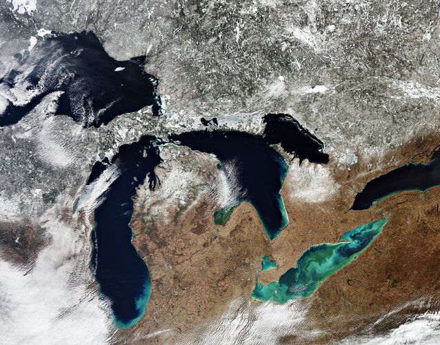
All five of North America’s Great Lakes are pictured in this spectacular image captured by the Copernicus Sentinel-3 mission: Lake Superior, Michigan, Huron, Erie, and Ontario.
Síť referenčních stanic HxGN SmartNet, poskytujících korekce pro GNSS měření, už také v ČR
28.5.2021 9:35 ZeměměřičOd letošního března pokrývá Českou republiku síť referenčních stanic HxGN SmartNet, poskytujících korekce pro GNSS měření. Nyní došlo k završení úředního procesu zahrnutí stanic sítě do nezávislého monitoringu VÚGTK, což znamená povolení k využívání sítě pro měření v katastru nemovitostí. HxGN SmartNet je celosvětová GNSS referenční síť, která pokrývá většinu území Evropy, Severní Ameriky a Austrálie. Síť podporuje veškeré […]
The post Síť referenčních stanic HxGN SmartNet, poskytujících korekce pro GNSS měření, už také v ČR appeared first on Zeměměřič.
Síť referenčních stanic HxGN SmartNet, poskytujících korekce pro GNSS měření také v ČR
28.5.2021 9:35 ZeměměřičOd letošního března pokrývá Českou republiku síť referenčních stanic HxGN SmartNet, poskytujících korekce pro GNSS měření. Nyní došlo k završení úředního procesu zahrnutí stanic sítě do nezávislého monitoringu VÚGTK, což znamená povolení k využívání sítě pro měření v katastru nemovitostí. HxGN SmartNet je celosvětová GNSS referenční síť, která pokrývá většinu území Evropy, Severní Ameriky a Austrálie. Síť podporuje veškeré […]
The post Síť referenčních stanic HxGN SmartNet, poskytujících korekce pro GNSS měření také v ČR appeared first on Zeměměřič.
ESA signs contract for new generation of Galileo
28.5.2021 9:14 ESA Navigation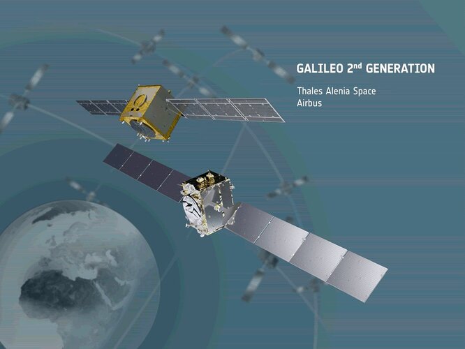
Acting on behalf of the European Commission, ESA has signed two contracts for an overall amount of €1.47 billion, to design and build the first batch of the second generation of Europe’s Galileo navigation satellites.
Scottish Forestry Uses Bluesky Aerial Photomaps to Monitor Tree Health
28.5.2021 9:00 GISCafe.com Webcasts-Webinars Leicestershire, UK, 27 May 2021 – Scottish Forestry, the government agency responsible for forestry policy, support and regulations in …ASPRS Announces Government Services Scholarship
28.5.2021 9:00 GISCafe.com Webcasts-Webinars Bethesda, MD May 27, 2021: The Awards Committee of the American Society for Photogrammetry and Remote Sensing (ASPRS) and the ASPRS Foundation …Výběrové řízení
28.5.2021 8:47 ČÚZK - předpisy a opatření Katastrální úřad pro Plzeňský kraj zveřejnil novou aktualitu: Ředitelka Katastrálního úřadu pro Plzeňský kraj vyhlašuje výběrové řízení na služební místo rada/odborný rada – interní auditor - IA, Katastrální úřad pro Plzeňský kraj, v oboru služby 3. Audit.Výběrové řízení
28.5.2021 8:47 ČÚZK /Urady/Katastralni-urady/Katastralni-urady/Katastralni-urad-pro-Plzensky-kraj/O-uradu/Aktuality/Vyberove-rizeni-(9)Rada/odborný rada – interní auditor
28.5.2021 8:43 ČÚZK - volná místa Katastrální úřad pro Plzeňský kraj vypisuje výběrové řízení na místo Rada/odborný rada – interní auditorRada/odborný rada – interní auditor
28.5.2021 8:43 ČÚZK /Urady/Katastralni-urady/Katastralni-urady/Katastralni-urad-pro-Plzensky-kraj/Uredni-deska/Oznameni-a-jina-uredni-sdeleni/Volna-mista/DMS/Rada-odborny-rada-–-interni-auditorRada/odborný rada – interní auditor
28.5.2021 8:43 ČÚZK - předpisy a opatření Katastrální úřad pro Plzeňský krajvypisuje výběrové řízení na místo
Rada/odborný rada – interní auditor
Ostrava vstupuje do nejistých dob s jasnou vizí svého prostorového rozvoje. Chce posilovat vitalitu, obytnost a udržitelnost (TZ)
28.5.2021 8:33 GISportal.cz
Městský ateliér prostorového plánování a architektury (MAPPA) představil výsledek své celoroční práce. Jedná se o Vizi prostorového rozvoje Ostravy, nástroj vycházející ze strategického plánu města, který bude pomáhat uvádět do života klíčové městské projekty. Poslouží jako podklad pro rozhodování politikům, úředníkům, projektantům či developerům. Vize prostorového rozvoje je postavena na maximu informací, které o městě […]
The post Ostrava vstupuje do nejistých dob s jasnou vizí svého prostorového rozvoje. Chce posilovat vitalitu, obytnost a udržitelnost (TZ) appeared first on GISportal.cz.
Vrchní referent/Rada – Oddělení dokumentace KN
28.5.2021 8:25 ČÚZK - předpisy a opatření Katastrální úřad pro Karlovarský kraj Katastrální pracoviště Karlovy Varyvypisuje výběrové řízení na místo
Vrchní referent/Rada – Oddělení dokumentace KN