


zprávy
zdroje zpráv:Uzavření Pobočky Benešov
6.6.2019 0:00 Státní pozemkový úřad Dne 20. 6. 2019 bude z provozních důvodů uzavřena pobočka Benešov. Děkujeme za pochopení.Ursa and ICEYE Extend Partnership for SAR Satellite Data and Products
5.6.2019 20:59 GISCafe.com Webcasts-Webinars New Space companies join forces to make SAR data more accessible and to develop new SAR-based products and servicesITHACA, N.Y., June 5, 2019 …
V Televizních novinách na TV Nova byl rozhovor s Jakubem o nové evropské legislativě pro drony
5.6.2019 20:23 UpVision V pátečních Televizních novinách na TV Nova jsme komentovali nově schválenou evropskou legislativu pro drony.O definitivním schválení nové evropské legislativy minulý pátek jsme informovali už na stránkách Aliance pro bezpilotní letecký průmysl. V současnosti už zbývá pouze oficiální publikování v Úředním věstníku EU v následujících dnech a od té doby začne plynout roční přechodné období na implementaci těchto nových pravidel ve všech státech EU.
Zde reportáž:
https://tn.nova.cz/clanek/cesko-zavede-nova-pravidla-pro-drony-registrace-a-zkousky.html
A zde článek na iDNES:
https://www.idnes.cz/ekonomika/domaci/drony-legislativa-zkousky-registrace.A190530_165345_ekonomika_fih
Mapbox Launches Data Services to Deliver High-Quality Map Data To Customers
5.6.2019 17:29 GISCafe.com Webcasts-Webinars SAN FRANCISCO, June 05, 2019 (GLOBE NEWSWIRE) -- Today, live location and data company Mapbox opens the door on Data Services, a new line of …Esri Software Powers Location Intelligence in Microsoft’s Defense System Demonstration
5.6.2019 17:29 GISCafe.com Webcasts-Webinars ‘Tactical Edge Vehicle’ Combines GIS, Artificial Intelligence, andAugmented Reality for Field Missions
REDLANDS, Calif. — …
Kratos Receives $31.8 Million Sole Source Unmanned Aerial Target Drone Contract Award from United States Air Force
5.6.2019 17:29 GISCafe.com Webcasts-Webinars SAN DIEGO, June 05, 2019 (GLOBE NEWSWIRE) -- Kratos Defense & Security Solutions, Inc. (Nasdaq: KTOS), a leading National Security Solutions …Den s INSPIRE - poslední možnost registrace
5.6.2019 16:01 CENIA - národní geoportál INSPIRE CENIA, česká informační agentura životního prostředí vás zve na seminář Den s INSPIRE, který je doprovodnou akcí konference Životní prostředí – prostředí pro život. Účast na akci je zdarma po předchozí registraci. Termín: 12. 6. 2019 od 13:00 hodin Místo konání: Vzdělávací a informační centrum Floret v Průhonicích Program: 13:00–14:30 Novelizace INSPIRE legislativy v ČR Jitka...Konference „Životní prostředí – prostředí pro život“ a Den s INSPIRE
5.6.2019 15:53 CENIA - národní geoportál INSPIRE CENIA, česká informační agentura životního prostředí a Slovenská agentura životného prostredia vás zvou na konferenci „Životní prostředí – prostředí pro život“, která se uskuteční ve dnech 12. – 13. června 2019 ve Vzdělávacím a Kongresovém centru Floret Průhonice. Registrovat se můžete prostřednictvím registračního formuláře. Den s INSPIRE V rámci konference proběhne dne 12. 6. 2019 v...Snow hits Australia
5.6.2019 15:34 ESA Observing the Earth
Parts of the Southern Tablelands on Australia’s east coast have been hit by unexpected snow
SARA scores at football match
5.6.2019 13:58 European GNSS Agency
SARA, a GSA-funded project developing a turnkey solution for search and rescue (SAR) and surveillance operations, has been successfully tested at a recent football match. Based on the test, the economic viability of using the solution for event filming and monitoring/surveying is currently being investigated.
The SARA project is working on engineering and commercialising a tethered drone-based SAR and surveillance solution using an already existing prototype. The solution is able to guarantee continuous operations by means of a patented cable used for power supply and as a secure data link. For drone navigation and control, as well as for target identification and localisation, SARA uses high-accuracy Galileo-enabled GNSS receivers.
Successful test
The test was carried out continuously for the duration of the football match, which offered an interesting test case requiring continuous surveillance over a two-hour period. The SARA terminal was set to monitor several players, whose positions were tracked over time. The footballers were localised using a Galileo-enabled GNSS receiver installed on the drone, which provided a reference, along with a computer vision algorithm that transformed pixels into 2D geographical positions.
Watch this: SARA for Football
A profile of the positions (one per second) was created and compared with the video material. “This qualitative test revealed interesting results in terms of target identification (the right player) and localisation within the football field zone, and also in terms of the limited cost of the equipment used,” said Marco Nisi, Head of Integrated GNSS Solutions at project partner Sistematica.
“This use case is now being studied to evaluate the economic viability of using the solution to film at events and to carry out monitoring and surveillance operations,” he said.
Range of applications
Maritime SAR is the primary target market but, as the football match test has shown, the solution has potential applications in other areas. One such area is security surveillance, particularly with the aim of preventing trespassing and detecting potential threats in open spaces. Possible use cases include monitoring and surveillance of building sites and other infrastructure, and security surveillance at major sporting events.
Read this: KAUST wins GSA Special Prize at ERL Emergency Local Tournament 2019
“In particular, as a very promising side market, the SARA team is continuing to address the technological challenges and to experiment with the business model with a view to reaching the sports domain as a provider of event surveillance management solutions and livestream broadcasting,” Nisi said.
The solution will be further tested in Szczecin, Poland in September 2019, where the drone will be operated on board a vessel to simulate a maritime SAR scenario. In this case, the drone will act as a vertical pylon and will be set up in “follow the ship” mode, making it possible to survey and identify and locate targets with an extended coverage of several nautical miles.
Media note: This feature can be republished without charge provided the European GNSS Agency (GSA) is acknowledged as the source at the top or the bottom of the story. You must request permission before you use any of the photographs on the site. If you republish, we would be grateful if you could link back to the GSA website (http://www.gsa.europa.eu).
SARA scores at football match
5.6.2019 13:58 European GNSS Agency
SARA, a GSA-funded project developing a turnkey solution for search and rescue (SAR) and surveillance operations, has been successfully tested at a recent football match. Based on the test, the economic viability of using the solution for event filming and monitoring/surveying is currently being investigated.
The SARA project is working on engineering and commercialising a tethered drone-based SAR and surveillance solution using an already existing prototype. The solution is able to guarantee continuous operations by means of a patented cable used for power supply and as a secure data link. For drone navigation and control, as well as for target identification and localisation, SARA uses high-accuracy Galileo-enabled GNSS receivers.
Successful test
The test was carried out continuously for the duration of the football match, which offered an interesting test case requiring continuous surveillance over a two-hour period. The SARA terminal was set to monitor several players, whose positions were tracked over time. The footballers were localised using a Galileo-enabled GNSS receiver installed on the drone, which provided a reference, along with a computer vision algorithm that transformed pixels into 2D geographical positions.
Watch this: SARA for Football
A profile of the positions (one per second) was created and compared with the video material. “This qualitative test revealed interesting results in terms of target identification (the right player) and localisation within the football field zone, and also in terms of the limited cost of the equipment used,” said Marco Nisi, Head of Integrated GNSS Solutions at project partner Sistematica.
“This use case is now being studied) to evaluate the economic viability of using the solution to film at events and to carry out monitoring and surveillance operations,” he said.
Range of applications
Maritime SAR is the primary target market but, as the football match test has shown, the solution has potential applications in other areas. One such area is security surveillance, particularly with the aim of preventing trespassing and detecting potential threats in open spaces. Possible use cases include monitoring and surveillance of building sites and other infrastructure, and security surveillance at major sporting events.
Read this: KAUST wins GSA Special Prize at ERL Emergency Local Tournament 2019
“In particular, as a very promising side market, the SARA team is continuing to address the technological challenges and to experiment with the business model with a view to reaching the sports domain as a provider of event surveillance management solutions and livestream broadcasting,” Nisi said.
The solution will be further tested in Szczecin, Poland in September 2019, where the drone will be operated on board a vessel to simulate a maritime SAR scenario. In this case, the drone will act as a vertical pylon and will be set up in “follow the ship” mode, making it possible to survey and identify and locate targets with an extended coverage of several nautical miles.
Media note: This feature can be republished without charge provided the European GNSS Agency (GSA) is acknowledged as the source at the top or the bottom of the story. You must request permission before you use any of the photographs on the site. If you republish, we would be grateful if you could link back to the GSA website (http://www.gsa.europa.eu).
SARA scores at football match
5.6.2019 13:58 European GNSS AgencySARA, a GSA-funded project developing a turnkey solution for search and rescue (SAR) and surveillance operations, has been successfully tested at a recent football match. Based on the test, the economic viability of using the solution for event filming and monitoring/surveying is currently being investigated.
The SARA project is working on engineering and commercialising a tethered drone-based SAR and surveillance solution using an already existing prototype. The solution is able to guarantee continuous operations by means of a patented cable used for power supply and as a secure data link. For drone navigation and control, as well as for target identification and localisation, SARA uses high-accuracy Galileo-enabled GNSS receivers.
Successful test
The test was carried out continuously for the duration of the football match, which offered an interesting test case requiring continuous surveillance over a two-hour period. The SARA terminal was set to monitor several players, whose positions were tracked over time. The footballers were localised using a Galileo-enabled GNSS receiver installed on the drone, which provided a reference, along with a computer vision algorithm that transformed pixels into 2D geographical positions.
Watch this: SARA for Football
A profile of the positions (one per second) was created and compared with the video material. “This qualitative test revealed interesting results in terms of target identification (the right player) and localisation within the football field zone, and also in terms of the limited cost of the equipment used,” said Marco Nisi, Head of Integrated GNSS Solutions at project partner Sistematica.
“This use case is now being studied) to evaluate the economic viability of using the solution to film at events and to carry out monitoring and surveillance operations,” he said.
Range of applications
Maritime SAR is the primary target market but, as the football match test has shown, the solution has potential applications in other areas. One such area is security surveillance, particularly with the aim of preventing trespassing and detecting potential threats in open spaces. Possible use cases include monitoring and surveillance of building sites and other infrastructure, and security surveillance at major sporting events.
Read this: KAUST wins GSA Special Prize at ERL Emergency Local Tournament 2019
“In particular, as a very promising side market, the SARA team is continuing to address the technological challenges and to experiment with the business model with a view to reaching the sports domain as a provider of event surveillance management solutions and livestream broadcasting,” Nisi said.
The solution will be further tested in Szczecin, Poland in September 2019, where the drone will be operated on board a vessel to simulate a maritime SAR scenario. In this case, the drone will act as a vertical pylon and will be set up in “follow the ship” mode, making it possible to survey and identify and locate targets with an extended coverage of several nautical miles.
Media note: This feature can be republished without charge provided the European GNSS Agency (GSA) is acknowledged as the source at the top or the bottom of the story. You must request permission before you use any of the photographs on the site. If you republish, we would be grateful if you could link back to the GSA website (http://www.gsa.europa.eu).
Dun & Bradstreet Announces Geospatial Data Science Scholarship in Partnership with the United States Geospatial Intelligence Foundation
5.6.2019 13:25 GISCafe.com Webcasts-Webinars June 4, 2019 (San Antonio, TX) – Dun & Bradstreet today announced a partnership with the United States Geospatial Intelligence …Blue Marble Releases Service Pack 1 (SP1) for Geographic Calculator 2019 with Updates and Improvements Throughout the Application
5.6.2019 13:20 GISCafe.com Webcasts-Webinars Hallowell, Maine – June 4, 2019 – Blue Marble Geographics (bluemarblegeo.com) has released a service pack update to its coordinate …USGIF Recognizes Dr. Annette J. Krygiel with the 2019 Lundahl-Finnie Lifetime Achievement Award
5.6.2019 13:09 GISCafe.com Webcasts-Webinars Krygiel honored for decades of influential service to the GEOINT CommunitySan Antonio, Texas (June 4, 2019) — The United States Geospatial …
USGIF Announces 2019 Achievement Award Winners
5.6.2019 13:04 GISCafe.com Webcasts-Webinars Outstanding organizations and individuals recognized for contributions to the geospatial intelligence communitySan Antonio, Texas (June 4, …
Kvalita koupacích vod v sezóně 2019
5.6.2019 12:01 CENIA - národní geoportál INSPIRE Stejně jako v předchozích letech jsou na geoportálu k dispozici informace o kvalitě koupacích vod v aktuální sezóně. Do seznamu mapových kompozic přibyla kompozice "SZÚ - Kvalita koupacích vod - sezóna 2019", která bude pravidelně aktualizována každý týden po dobu celé koupací sezóny. Data jsou dostupná taktéž prostřednictvím WMS služby geoportálu na adrese...EU a ESA: Kosmický den v Bruselu – tři rady ministrů k budoucnosti kosmických aktivit v jeden den
5.6.2019 10:28 Český Kosmický PortálDne 28. května 2019 se uskutečnilo zasedání vesmírné části Rady pro konkurenceschopnost a Rada ESA na ministerské úrovni. Poprvé po 8 letech však byla tato zasedání obohacena i o jednání tzv. Rady pro vesmír (Space Council), smíšené platformy Rady EU a Rady ESA, na níž ministři členských států obou mezinárodních organizací diskutují o vzájemné spolupráci EU a ESA a o dalším směřování kosmických aktivit v Evropě. Impulzem pro obnovení Space Council je příprava nového Kosmického programu EU a potřeba užší spolupráce v návaznosti na dynamický rozvoj kosmického průmyslu a využití družicových systémů ve světě.
rada/odborný rada – právník Katastrálního úřadu pro hlavní město Prahu, Katastrální pracoviště Praha
5.6.2019 9:09 ČÚZK /Urady/Katastralni-urady/Katastralni-urady/Katastralni-urad-pro-hlavni-mesto-Prahu/Uredni-deska/Oznameni-a-jina-uredni-sdeleni/Volna-mista/rada-odborny-rada-–-pravnik-Katastralniho-uradu-prrada/odborný rada – právník Katastrálního úřadu pro hlavní město Prahu, Katastrální pracoviště Praha
5.6.2019 9:09 ČÚZK - volná místa Katastrální úřad pro hlavní město Prahu - Katastrální pracoviště Praha vypisuje výběrové řízení na místo rada/odborný rada – právník Katastrálního úřadu pro hlavní město Prahu, Katastrální pracoviště Praharada/odborný rada – právník Katastrálního úřadu pro hlavní město Prahu, Katastrální pracoviště Praha
5.6.2019 9:09 ČÚZK - předpisy a opatření Katastrální úřad pro hlavní město Prahu - Katastrální pracoviště Prahavypisuje výběrové řízení na místo
rada/odborný rada – právník Katastrálního úřadu pro hlavní město Prahu, Katastrální pracoviště Praha
Sanjay Gangal interviews Matteo Sgrenzaroli, R&D Manager from Gexcel at SPAR 3D conference
5.6.2019 9:00 GISCafe.com Webcasts-WebinarsHERON®-Verity Integration Introduces Real-Time 3D Mobile Mapping and Construction Verification
5.6.2019 9:00 GISCafe.com Webcasts-Webinars The collaboration between HERON, the latest wearable mobile scanners from Gexcel and Verity construction verification software from …uzavení pracoviště
5.6.2019 7:14 ČÚZK - předpisy a opatření Katastrální úřad pro Olomoucký kraj - Katastrální pracoviště Olomouc zveřejnil novou aktualitu: OZNÁMENÍ. V pondělí 17. června 2019 budou Katastrální úřad pro Olomoucký kraj a Katastrální pracoviště Olomouc z důvodu přerušení dodávky elektřiny UZAVŘENY.Děkujeme za pochopení.
uzavení pracoviště
5.6.2019 7:14 ČÚZK /Urady/Katastralni-urady/Katastralni-urady/Katastralni-urad-pro-Olomoucky-kraj/Katastralni-pracoviste/KP-Olomouc/O-uradu/Aktuality/uzaveni-pracovisteuzavení pracoviště
5.6.2019 7:09 ČÚZK /Urady/Katastralni-urady/Katastralni-urady/Katastralni-urad-pro-Olomoucky-kraj/O-uradu/Aktuality/uzaveni-pracovisteuzavení pracoviště
5.6.2019 7:09 ČÚZK - předpisy a opatření Katastrální úřad pro Olomoucký kraj zveřejnil novou aktualitu: OZNÁMENÍ. V pondělí 17. června 2019 budou Katastrální úřad pro Olomoucký kraj a Katastrální pracoviště Olomouc z důvodu přerušení dodávky elektřiny UZAVŘENY.Děkujeme za pochopení.
Kvalita koupacích vod v koupacích sezónách 2016-2018
5.6.2019 2:00 Cenia - Katalog metadat ČR - INSPIRE Kvalita koupacích vod v koupací sezóně v letech 2016-2018.Vricon and Cesium partner to bring users streaming 3D geodata
5.6.2019 0:49 GISCafe.com Webcasts-Webinars McLean, Virginia, June 04, 2019 (GLOBE NEWSWIRE) -- Vricon, a producer of geospatial 3D solutions, and Cesium—a complete platform for building …Připravili jsme další seminář pro studenty lednické a olomoucké fakulty
5.6.2019 0:00 Státní pozemkový úřad V průběhu dubna a května proběhl tradiční „Krajinářský workshop 2019“, kterého se zúčastnili studenti Zahradnické fakulty Mendelovy univerzity z Lednice a Přírodovědecké fakulty Univerzity Palackého v Olomouci.V letošním roce pracovalo 6 týmů po 6 studentech na krajinářských tématech v různých lokalitách (Břeclav, Dolní Věstonice, Lednice, Lomnice, Vojnice u Olomouce).
Live updates from Take That concert at the John Smith's Stadium - ExaminerLive (Google Maps)
4.6.2019 22:03 GISCafe.com Webcasts-WebinarsSanjay Gangal interviews Wayne Szametat, Director of Sales from Teledyne Optech at SPAR 3D
4.6.2019 22:03 GISCafe.com Webcasts-WebinarsA bird's-eye view of these Glendale medical offices reveals resemblance to swastikas - AZCentral (Google Maps)
4.6.2019 22:03 GISCafe.com Webcasts-WebinarsBoeing Invests in Commercial UAS Services Provider Robotic Skies
4.6.2019 17:55 GISCafe.com Webcasts-Webinars Startup manages maintenance, inspection and alteration services for global manufacturers and operators of commercial unmanned aircraft …TomTom Traffic Index: Mumbai takes Crown of ‘Most Traffic Congested City’ in World
4.6.2019 17:50 GISCafe.com Webcasts-Webinars Global congestion up – but new technology signals way forwardAMSTERDAM — (BUSINESS WIRE) — June 3, 2019 —
TomTom …
PolyExplore Announces DeepMap as a New Customer
4.6.2019 17:50 GISCafe.com Webcasts-Webinars SAN JOSE, Calif. — (BUSINESS WIRE) — June 3, 2019 —Polynesian Exploration (PolyExplore), a manufacturer of economical
…
Dassault Systèmes and Chinese GIS Software Leader SuperMap Partner to Drive New Approach to Innovation for Construction, Cities and Territories
4.6.2019 17:50 GISCafe.com Webcasts-Webinars Partners sign MoU to co-engage on smart city and largetransportation infrastructure projects to enhance collaboration, urban
…
Drone Aviation Selected by Prime Contractor for Additional $1.7 Million Award
4.6.2019 17:50 GISCafe.com Webcasts-Webinars JACKSONVILLE, FL, June 04, 2019 (GLOBE NEWSWIRE) -- Drone Aviation Holding Corp. (OTCQB: DRNE) (“Drone Aviation” or the “Company”), a …CoreLogic Reports April Home Prices Increased by 3.6% Year Over Year
4.6.2019 17:50 GISCafe.com Webcasts-Webinars Annual price growth shows the first acceleration since March 2018The HPI Forecast indicates prices will increase by 4.7% by …
Intermap Announces Two Telecom Geoint Software Contracts
4.6.2019 17:50 GISCafe.com Webcasts-Webinars DENVER, June 4, 2019 — (PRNewswire) — Intermap Technologies announced today that it signed contracts with two major telecommunication …Drone Delivery Canada Announces Commercial Agreement with Air Canada
4.6.2019 17:50 GISCafe.com Webcasts-Webinars TORONTO, June 4, 2019 — (PRNewswire) — Drone Delivery Canada Corp. (TSXV: FLT, OTC: TAKOF) (the "Company" or "DDC") is pleased to …IAI Places US$1.8 Million Order for Orbit's Airborne Audio Solution for Its "Heron TP" UAV
4.6.2019 17:50 GISCafe.com Webcasts-Webinars Orbit's Audio Management System will integrate with Heron TP's airborne satcom terminals and ground tracking systemsTEL AVIV, Israel, June 4, 2019 …
FoxFury Introduces The Rugo™ 2 Drone & Camera Light
4.6.2019 17:50 GISCafe.com Webcasts-Webinars Ultra-durable lighting tool for the on-the-go videographer, photographer, and drone pilotOCEANSIDE, Calif., June 4, 2019 — (PRNewswire) …
Ursa and HawkEye 360 Join Forces to Develop Geospatial Information Solutions
4.6.2019 17:50 GISCafe.com Webcasts-Webinars The partnership brings together space-based radar and radio frequency data analytics to advance global monitoring capabilitiesITHACA, N.Y., June 4, …
RACE
4.6.2019 16:56 ESA Observing the Earth
RACE
Access latest information on the impacts of COVID-19
RACE
4.6.2019 16:56 ESA Observing the Earth
Rapid action on coronavirus and EO
Access latest information on the impacts of COVID-19
Oznámení
4.6.2019 15:58 ČÚZK /Urady/Katastralni-urady/Katastralni-urady/Katastralni-urad-pro-Moravskoslezsky-kraj/Katastralni-pracoviste/KP-Opava/O-uradu/Aktuality/OznameniOznámení
4.6.2019 15:58 ČÚZK - předpisy a opatření Katastrální úřad pro Moravskoslezský kraj - Katastrální pracoviště Opava zveřejnil novou aktualitu:OZNÁMENÍ
Od 5. 6. 2019 lze na Katastrálním pracovišti Opava hradit veškeré správní poplatky a úplaty za výstupy z KN (mimo službu sledování změn) i prostřednictvím platebních karet.
Oznámení
4.6.2019 15:58 ČÚZK - předpisy a opatření Katastrální úřad pro Moravskoslezský kraj - Katastrální pracoviště Opava zveřejnil novou aktualitu:Od 5. 6. 2019 lze na Katastrálním pracovišti Opava hradit veškeré správní poplatky a úplaty za výstupy z KN (mimo službu sledování změn) i prostřednictvím platebních karet.
Interesantní pracovní nabídka od Vertical Images s.r.o.
4.6.2019 13:53 Blogující geomatici - FAV ZČU Firma Vertical Images s.r.o. hledá geodety, fotogrammetry, geomatiky a informatiky do svého týmu, především pro práci v oblastech 3D modelování, 3D laserového skenování, fotogrammetrie a termografie. Více informací naleznete na přiloženém obrázku .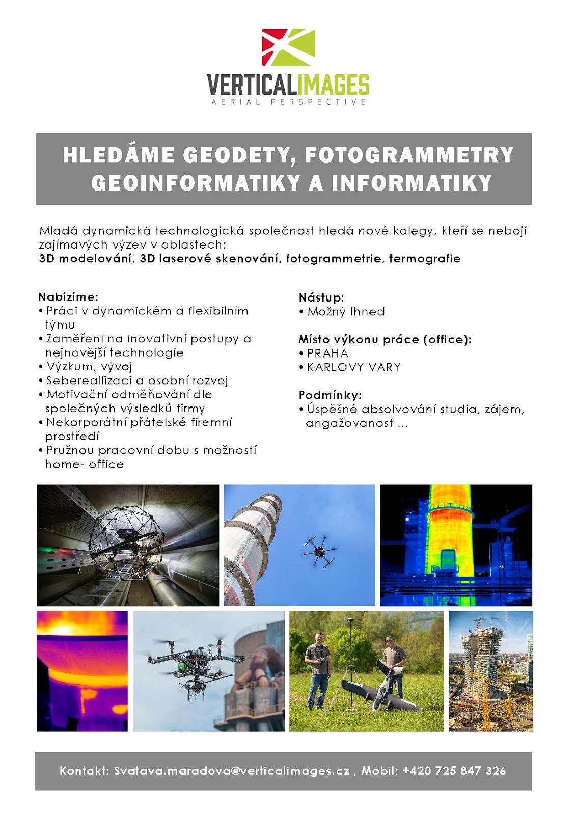
7. referent KN – právník do právního oddělení XI.
4.6.2019 13:48 ČÚZK /Urady/Katastralni-urady/Katastralni-urady/Katastralni-urad-pro-hlavni-mesto-Prahu/O-uradu/Aktuality/VR-04-06-20197. referent KN – právník do právního oddělení XI.
4.6.2019 13:48 ČÚZK - předpisy a opatření Katastrální úřad pro hlavní město Prahu zveřejnil novou aktualitu: Ředitel úřadu vyhlašuje výběrová řízení na služební místo:referent KN – právník do právního oddělení XI.
7. referent KN – právník do právního oddělení III.
4.6.2019 13:48 ČÚZK /Urady/Katastralni-urady/Katastralni-urady/Katastralni-urad-pro-hlavni-mesto-Prahu/O-uradu/Aktuality/VR-04-06-2019referent KN – právník do právního oddělení III.
4.6.2019 13:48 ČÚZK - předpisy a opatření Katastrální úřad pro hlavní město Prahu zveřejnil novou aktualitu: Ředitel úřadu vyhlašuje výběrová řízení na služební místa:referent KN – právník do právního oddělení III.
odborný referent/vrchní referent – návrh zápisu v katastru
7. referent KN – právník do právního oddělení III.
4.6.2019 13:48 ČÚZK - předpisy a opatření Katastrální úřad pro hlavní město Prahu zveřejnil novou aktualitu: Ředitel úřadu vyhlašuje výběrová řízení na služební místo:referent KN – právník do právního oddělení III.
6. referent KN – právník do právního oddělení III.
4.6.2019 13:48 ČÚZK - předpisy a opatření Katastrální úřad pro hlavní město Prahu zveřejnil novou aktualitu: Ředitel úřadu vyhlašuje výběrová řízení na služební místo:referent KN – právník do právního oddělení III.
VŘ - 04.06.2019
4.6.2019 13:48 ČÚZK /Urady/Katastralni-urady/Katastralni-urady/Katastralni-urad-pro-hlavni-mesto-Prahu/O-uradu/Aktuality/VR-04-06-2019VŘ - 04.06.2019
4.6.2019 13:48 ČÚZK - předpisy a opatření Katastrální úřad pro hlavní město Prahu zveřejnil novou aktualitu: Ředitel úřadu vyhlašuje výběrové řízení na služební místo:rada/odborný rada – interní auditor Katastrálního úřadu pro hlavní město Prahu
referent KN – právník do právního oddělení III.
4.6.2019 13:48 ČÚZK - předpisy a opatření Katastrální úřad pro hlavní město Prahu zveřejnil novou aktualitu: Ředitel úřadu vyhlašuje výběrové řízení na služební místo:referent KN – právník do právního oddělení III.
referent KN – právník do právního oddělení III.
4.6.2019 13:48 ČÚZK - předpisy a opatření Katastrální úřad pro hlavní město Prahu zveřejnil novou aktualitu: Ředitel úřadu vyhlašuje výběrová řízení na služební místo:referent KN – právník do právního oddělení III.
VŘ - 04.06.2019
4.6.2019 13:48 ČÚZK - předpisy a opatření Katastrální úřad pro hlavní město Prahu zveřejnil novou aktualitu: Ředitel úřadu vyhlašuje výběrové řízení na služební místo:rada/odborný rada – interní auditor Katastrálního úřadu pro hlavní město Prahu
referent KN – právník do právního oddělení III.
4.6.2019 13:48 ČÚZK /Urady/Katastralni-urady/Katastralni-urady/Katastralni-urad-pro-hlavni-mesto-Prahu/O-uradu/Aktuality/VR-04-06-2019referent KN – právník do právního oddělení III.
4.6.2019 13:48 ČÚZK - předpisy a opatření Katastrální úřad pro hlavní město Prahu zveřejnil novou aktualitu: Ředitel úřadu vyhlašuje výběrová řízení na služební místa:referent KN – právník do právního oddělení III.
odborný referent/vrchní referent – návrh zápisu v katastru
odborný referent/vrchní referent – návrh zápisu v katastru
4.6.2019 13:45 ČÚZK /Urady/Katastralni-urady/Katastralni-urady/Katastralni-urad-pro-hlavni-mesto-Prahu/Uredni-deska/Oznameni-a-jina-uredni-sdeleni/Volna-mista/na-samostatne-systemizovane-sluzebni-misto-rada-ododborný referent/vrchní referent – návrh zápisu v katastru
4.6.2019 13:45 ČÚZK - volná místa Katastrální úřad pro hlavní město Prahu - Katastrální pracoviště Plzeň-sever vypisuje výběrové řízení na místo odborný referent/vrchní referent – návrh zápisu v katastrurada/odborný rada – interní auditor Katastrálního úřadu pro hlavní město Prahu
4.6.2019 13:45 ČÚZK - předpisy a opatření Katastrální úřad pro hlavní město Prahuvypisuje výběrové řízení na místo
rada/odborný rada – interní auditor Katastrálního úřadu pro hlavní město Prahu
na samostatné systemizované služební místo rada/odborný rada – interní auditor
4.6.2019 13:45 ČÚZK - volná místa Katastrální úřad pro hlavní město Prahu vypisuje výběrové řízení na místo na samostatné systemizované služební místo rada/odborný rada – interní auditorodborný referent/vrchní referent – návrh zápisu v katastru
4.6.2019 13:45 ČÚZK - předpisy a opatření Katastrální úřad pro hlavní město Prahu - Katastrální pracoviště Plzeň-severvypisuje výběrové řízení na místo
odborný referent/vrchní referent – návrh zápisu v katastru
odborný referent/vrchní referent – návrh zápisu v katastru
4.6.2019 13:45 ČÚZK - volná místa Katastrální úřad pro hlavní město Prahu - Katastrální pracoviště Praha vypisuje výběrové řízení na místo odborný referent/vrchní referent – návrh zápisu v katastruna samostatné systemizované služební místo rada/odborný rada – interní auditor
4.6.2019 13:45 ČÚZK /Urady/Katastralni-urady/Katastralni-urady/Katastralni-urad-pro-hlavni-mesto-Prahu/Uredni-deska/Oznameni-a-jina-uredni-sdeleni/Volna-mista/na-samostatne-systemizovane-sluzebni-misto-rada-ododborný referent/vrchní referent – návrh zápisu v katastru
4.6.2019 13:45 ČÚZK - předpisy a opatření Katastrální úřad pro hlavní město Prahu - Katastrální pracoviště Prahavypisuje výběrové řízení na místo
odborný referent/vrchní referent – návrh zápisu v katastru
rada/odborný rada – interní auditor Katastrálního úřadu pro hlavní město Prahu
4.6.2019 13:45 ČÚZK /Urady/Katastralni-urady/Katastralni-urady/Katastralni-urad-pro-hlavni-mesto-Prahu/Uredni-deska/Oznameni-a-jina-uredni-sdeleni/Volna-mista/na-samostatne-systemizovane-sluzebni-misto-rada-odrada/odborný rada – interní auditor Katastrálního úřadu pro hlavní město Prahu
4.6.2019 13:45 ČÚZK - volná místa Katastrální úřad pro hlavní město Prahu vypisuje výběrové řízení na místo rada/odborný rada – interní auditor Katastrálního úřadu pro hlavní město PrahuRevize v k.ú. Třebušín
4.6.2019 13:35 ČÚZK - předpisy a opatření Katastrální úřad pro Ústecký kraj - Katastrální pracoviště Litoměřicezveřejnil novou aktualitu: Vážení klienti, oznamujeme Vám, že od 1.7.2019 - do 31.5.2020 bude probíhat v katastrálním území Třebušín obce Třebušín revize katastru nemovitostí. Účelem provádění revize je soulad údajů katastru nemovitostí se skutečným stavem v terénu, kdy jsou zjišťovány změny a ověřován dosavadní stav předmětu evidence katastru nemovitostí.
Revize v k.ú. Třebušín
4.6.2019 13:35 ČÚZK /Urady/Katastralni-urady/Katastralni-urady/Katastralni-urad-pro-Ustecky-kraj/Katastralni-pracoviste/KP-Litomerice/O-uradu/Aktuality/Revize-v-k-u-TrebusinRevize v k.ú. Horní Chobolice
4.6.2019 13:34 ČÚZK - předpisy a opatření Katastrální úřad pro Ústecký kraj - Katastrální pracoviště Litoměřicezveřejnil novou aktualitu: Vážení klienti, oznamujeme Vám, že od 1.7.2019 - do 31.1.2020 bude probíhat v katastrálním území Horní Chobolice obce Liběšice revize katastru nemovitostí. Účelem provádění revize je soulad údajů katastru nemovitostí se skutečným stavem v terénu, kdy jsou zjišťovány změny a ověřován dosavadní stav předmětu evidence katastru nemovitostí.
Revize v k.ú. Horní Chobolice
4.6.2019 13:34 ČÚZK /Urady/Katastralni-urady/Katastralni-urady/Katastralni-urad-pro-Ustecky-kraj/Katastralni-pracoviste/KP-Litomerice/O-uradu/Aktuality/Revize-v-k-u-Horni-ChoboliceRevize v k.ú. Vetlá
4.6.2019 13:33 ČÚZK - předpisy a opatření Katastrální úřad pro Ústecký kraj - Katastrální pracoviště Litoměřicezveřejnil novou aktualitu: Vážení klienti, oznamujeme Vám, že od 3.6.2019 - do 20.12.2019 bude probíhat v katastrálním území Vetlá obce Vrbice revize katastru nemovitostí. Účelem provádění revize je soulad údajů katastru nemovitostí se skutečným stavem v terénu, kdy jsou zjišťovány změny a ověřován dosavadní stav předmětu evidence katastru nemovitostí.
Revize v k.ú. Vetlá
4.6.2019 13:33 ČÚZK /Urady/Katastralni-urady/Katastralni-urady/Katastralni-urad-pro-Ustecky-kraj/Katastralni-pracoviste/KP-Litomerice/O-uradu/Aktuality/Revize-v-k-u-VetlaRevize v k.ú. Třebívlice
4.6.2019 13:29 ČÚZK - předpisy a opatření Katastrální úřad pro Ústecký kraj - Katastrální pracoviště Litoměřicezveřejnil novou aktualitu: Vážení klienti, oznamujeme Vám, že od 3.6.2019 - do 30.4.2020 bude probíhat v katastrálním území Třebívlice obce Třebívlice revize katastru nemovitostí. Účelem provádění revize je soulad údajů katastru nemovitostí se skutečným stavem v terénu, kdy jsou zjišťovány změny a ověřován dosavadní stav předmětu evidence katastru nemovitostí.
Revize v k.ú. Třebívlice
4.6.2019 13:29 ČÚZK /Urady/Katastralni-urady/Katastralni-urady/Katastralni-urad-pro-Ustecky-kraj/Katastralni-pracoviste/KP-Litomerice/O-uradu/Aktuality/Revize-v-k-u-TrebivliceRevize v k.ú. Hlupice
4.6.2019 13:27 ČÚZK - předpisy a opatření Katastrální úřad pro Ústecký kraj - Katastrální pracoviště Litoměřicezveřejnil novou aktualitu: Vážení klienti, oznamujeme Vám, že od 27.5.2019 - do 28.2.2020 bude probíhat v katastrálním území Hlupice obce Lovečkovice revize katastru nemovitostí. Účelem provádění revize je soulad údajů katastru nemovitostí se skutečným stavem v terénu, kdy jsou zjišťovány změny a ověřován dosavadní stav předmětu evidence katastru nemovitostí.
Revize v k.ú. Hlupice
4.6.2019 13:27 ČÚZK /Urady/Katastralni-urady/Katastralni-urady/Katastralni-urad-pro-Ustecky-kraj/Katastralni-pracoviste/KP-Litomerice/O-uradu/Aktuality/Revize-v-k-u-HlupiceRevize v k.ú. Vlastislav
4.6.2019 13:24 ČÚZK - předpisy a opatření Katastrální úřad pro Ústecký kraj - Katastrální pracoviště Litoměřicezveřejnil novou aktualitu: Vážení klienti, oznamujeme Vám, že od 15.4.2019 - do 15.11.2019 bude probíhat v katastrálním území Vlastislav obce Vlastislav revize katastru nemovitostí. Účelem provádění revize je soulad údajů katastru nemovitostí se skutečným stavem v terénu, kdy jsou zjišťovány změny a ověřován dosavadní stav předmětu evidence katastru nemovitostí.
Revize v k.ú. Vlastislav
4.6.2019 13:24 ČÚZK /Urady/Katastralni-urady/Katastralni-urady/Katastralni-urad-pro-Ustecky-kraj/Katastralni-pracoviste/KP-Litomerice/O-uradu/Aktuality/Revize-v-k-u-VlastislavRevize v k.ú. Starý Týn
4.6.2019 13:23 ČÚZK /Urady/Katastralni-urady/Katastralni-urady/Katastralni-urad-pro-Ustecky-kraj/Katastralni-pracoviste/KP-Litomerice/O-uradu/Aktuality/Revize-v-k-u-Stary-TynRevize v k.ú. Starý Týn
4.6.2019 13:23 ČÚZK - předpisy a opatření Katastrální úřad pro Ústecký kraj - Katastrální pracoviště Litoměřicezveřejnil novou aktualitu: Vážení klienti, oznamujeme Vám, že od 9.4.2019 - do 31.10.2019 bude probíhat v katastrálním území Starý Týn obce Úštěk revize katastru nemovitostí. Účelem provádění revize je soulad údajů katastru nemovitostí se skutečným stavem v terénu, kdy jsou zjišťovány změny a ověřován dosavadní stav předmětu evidence katastru nemovitostí.
Revize v k.ú. Štětí II
4.6.2019 13:21 ČÚZK - předpisy a opatření Katastrální úřad pro Ústecký kraj - Katastrální pracoviště Litoměřicezveřejnil novou aktualitu: Vážení klienti, oznamujeme Vám, že od 18.3.2019 - do 15.10.2019 bude probíhat v katastrálním území Štětí II obce Štětí revize katastru nemovitostí. Účelem provádění revize je soulad údajů katastru nemovitostí se skutečným stavem v terénu, kdy jsou zjišťovány změny a ověřován dosavadní stav předmětu evidence katastru nemovitostí.
Revize v k.ú. Štětí II
4.6.2019 13:21 ČÚZK /Urady/Katastralni-urady/Katastralni-urady/Katastralni-urad-pro-Ustecky-kraj/Katastralni-pracoviste/KP-Litomerice/O-uradu/Aktuality/Revize-v-k-u-Steti-IIRevize v k.ú. Čakovice u Radouně
4.6.2019 13:20 ČÚZK - předpisy a opatření Katastrální úřad pro Ústecký kraj - Katastrální pracoviště Litoměřicezveřejnil novou aktualitu: Vážení klienti, oznamujeme Vám, že od 18.3.2019 - do 15.10.2019 bude probíhat v katastrálním území Čakovice u Radouně obce Štětí revize katastru nemovitostí. Účelem provádění revize je soulad údajů katastru nemovitostí se skutečným stavem v terénu, kdy jsou zjišťovány změny a ověřován dosavadní stav předmětu evidence katastru nemovitostí.
Revize v k.ú. Čakovice u Radouně
4.6.2019 13:20 ČÚZK /Urady/Katastralni-urady/Katastralni-urady/Katastralni-urad-pro-Ustecky-kraj/Katastralni-pracoviste/KP-Litomerice/O-uradu/Aktuality/Revize-v-k-u-Cakovice-u-RadouneRevize v k.ú. Mladé
4.6.2019 13:19 ČÚZK - předpisy a opatření Katastrální úřad pro Ústecký kraj - Katastrální pracoviště Litoměřicezveřejnil novou aktualitu: Vážení klienti, oznamujeme Vám, že od 11.3.2019 - do 30.9.2019 bude probíhat v katastrálním území Mladé obce Liběšice revize katastru nemovitostí. Účelem provádění revize je soulad údajů katastru nemovitostí se skutečným stavem v terénu, kdy jsou zjišťovány změny a ověřován dosavadní stav předmětu evidence katastru nemovitostí.
Revize v k.ú. Mladé
4.6.2019 13:19 ČÚZK /Urady/Katastralni-urady/Katastralni-urady/Katastralni-urad-pro-Ustecky-kraj/Katastralni-pracoviste/KP-Litomerice/O-uradu/Aktuality/Revize-v-k-u-MladeZlínský kraj nově nabízí službu UtilityReport
4.6.2019 12:12 Hrdlička„Jde o elegantní, rychlý a bezplatný způsob, jak mohou občané podat žádost o vyjádření správcům inženýrských sítí a mít při tom jistotu, že na nikoho nezapomněli,“ řekl hejtman Zlínského kraje Jiří Čunek. Službu, jejímž provozovatelem je společnost HRDLIČKA spol. s r.o., doposud nabízelo na svých webových stránkách 7 měst ve Zlínském kraji a za její... View Article
The post Zlínský kraj nově nabízí službu UtilityReport appeared first on HRDLIČKA spol. s r.o. - komplexní služby v oblasti geodézie.
USGIF Announces 2019 Stu Shea Endowed Scholarship Recipient
4.6.2019 11:18 GISCafe.com Webcasts-Webinars Clark University’s Jaclyn Guz becomes second recipient of $15,000 scholarshipSan Antonio, Texas (June 3, 2019)— This morning at the …
SZÚ - Kvalita koupacích vod - sezóna 2019
4.6.2019 2:00 Cenia - Katalog metadat ČR - INSPIRE Kompozice obsahuje vrstvy s údaji o kvalitě koupacích vod v letním období roku 2019.SZÚ - Kvalita koupacích vod - sezóna 2018
4.6.2019 2:00 Cenia - Katalog metadat ČR - INSPIRE Kompozice obsahuje vrstvy s údaji o kvalitě koupacích vod v letním období roku 2018.Kvalita koupacích vod v koupacích sezónách 2016 a 2018
4.6.2019 2:00 Cenia - Katalog metadat ČR - INSPIRE Kvalita koupacích vod v koupací sezóně v letech 2016-2018.BlackSky Awarded NRO Contract for Commercial Imagery to Support U.S. Government Mission Needs
4.6.2019 1:40 GISCafe.com Webcasts-Webinars HERNDON, Va. — (BUSINESS WIRE) — June 3, 2019 —BlackSky,
a leading provider of geospatial intelligence, satellite …
Maxar Technologies Awarded Study Contract with U.S. National Reconnaissance Office for Commercial Imagery Capabilities
4.6.2019 1:40 GISCafe.com Webcasts-Webinars WESTMINSTER, Colo. — (BUSINESS WIRE) — June 3, 2019 —Maxar
Technologies (NYSE:MAXR) (TSX:MAXR) today announced that …
TomTom Traffic Index: Congestion Up, but New Technologies Show Promise in the U.S.
4.6.2019 1:40 GISCafe.com Webcasts-Webinars Cities Investing in Traffic Mitigation Tactics See Steady Improvements in Traffic CongestionAMSTERDAM, June 3, 2019 — (PRNewswire) — …
Cepton Launches New High-Speed SORA-P60 Lidar For Vehicle Scanning
3.6.2019 23:36 GISCafe.com Webcasts-Webinars New sensor provides industry-leading 1,200 scan lines per second forhigh-velocity vehicle scanning and classification
SAN JOSE, …
Orbit GT and MasterMind, USA, sign Reseller Agreement
3.6.2019 21:40 GISCafe.com Webcasts-Webinars Lokeren, Belgium, June 4th, 2019Orbit GT is pleased to announce that MasterMind, USA, has joined as Authorized Reseller of Orbit GT 3D Mapping …
OZNÁMENÍ
3.6.2019 20:25 ČÚZK /Urady/Katastralni-urady/Katastralni-urady/Katastralni-urad-pro-Moravskoslezsky-kraj/Katastralni-pracoviste/KP-Ostrava/O-uradu/Aktuality/OZNAMENIOZNÁMENÍ
3.6.2019 20:25 ČÚZK - předpisy a opatření Katastrální úřad pro Moravskoslezský kraj - Katastrální pracoviště Ostrava zveřejnil novou aktualitu:OZNÁMENÍ
Od 5. 6. 2019 lze na Katastrálním pracovišti Ostrava hradit veškeré správní poplatky a úplaty za výstupy z KN (mimo službu sledování změn) i prostřednictvím platebních karet.OZNÁMENÍ
3.6.2019 20:19 ČÚZK - předpisy a opatření Katastrální úřad pro Moravskoslezský kraj - Katastrální pracoviště Karviná zveřejnil novou aktualitu:OZNÁMENÍ
Od 7. 6. 2019 lze na Katastrálním pracovišti Karviná hradit veškeré správní poplatky a úplaty za výstupy z KN (mimo službu sledování změn) i prostřednictvím platebních karet.
OZNÁMENÍ
3.6.2019 20:19 ČÚZK /Urady/Katastralni-urady/Katastralni-urady/Katastralni-urad-pro-Moravskoslezsky-kraj/Katastralni-pracoviste/KP-Karvina/O-uradu/Aktuality/OZNAMENIBAE Systems Completes Acquisition of the Riptide Autonomous Solutions Business
3.6.2019 19:42 GISCafe.com Webcasts-Webinars ARLINGTON, Virginia — (BUSINESS WIRE) — June 3, 2019 —BAE Systems, Inc. has announced the purchase of the …
Maxar Earth Intelligence Solutions Expands its Support for the U.S. National Security Community
3.6.2019 16:14 GISCafe.com Webcasts-Webinars Company awarded $95M of new contracts from the U.S. Air Force,Special Operations Command and National Geospatial-Intelligence Agency
…
Space Dynamics Lab Names Former Intelligence Agency Director to Guidance Council
3.6.2019 16:14 GISCafe.com Webcasts-Webinars San Antonio, June 03, 2019 (GLOBE NEWSWIRE) -- Utah State University’s Space Dynamics Laboratory announced today that Robert Cardillo has been …BlackSky Begins Commercial Operations, Signs Agreement with HawkEye 360 to Include Radio Frequency Data in Its Geospatial Platform
3.6.2019 16:14 GISCafe.com Webcasts-Webinars SAN ANTONIO — (BUSINESS WIRE) — June 3, 2019 —Today at the USGIF-sponsored GEOINT Symposium in San Antonio, BlackSky,
…
Former FCC Chair Tom Wheeler Joins AirMap Board to Help Shape Future Unmanned Airspace Economy
3.6.2019 16:14 GISCafe.com Webcasts-Webinars SANTA MONICA, Calif., June 3, 2019 — (PRNewswire) — Today, AirMap, the leading global unmanned aerial systems traffic management (UTM) …Riverside Research Contributes in GEOINT Lightning Talks
3.6.2019 16:14 GISCafe.com Webcasts-Webinars WASHINGTON, June 3, 2019 — (PRNewswire) — As a not-for-profit serving the defense and intelligence communities, Riverside Research …Demetra delivers dividends for ELPROMA
3.6.2019 10:41 European GNSS Agency
ELPROMA, a Polish manufacturer of NTP/PTP time servers, has won a seven-figure US$ contract to supply Rubidium IEEE1588 NTS-5000 servers to support a country-scale modern smart grid system in Asia. The servers, which are custom built (designated “Safe Time”), incorporate a modified version of the cyber-security TSI#2 solution developed as part of the Horizon 2020 ‘DEMonstrator of EGNSS services based on Time Reference Architecture’ (Demetra) project, in which ELPROMA participated in 2015-2016.
While it is not yet possible, for reasons of commercial secrecy, to name the client country, we can reveal that the contract is for a total of over 350 mostly advanced Rubidium-class PTP IEEE1588 time servers. These servers will ensure the cyber security and robust nanosecond synchronisation of the country-scale electricity grid, which is in the process of transition from a classical grid to a state-of-the-art IEC61850 system capable of safely distributing power throughout the country.
Read this: Time as a service with Galileo
“This is the biggest one-off deal of its kind so far,” Tomasz Widomski, a member of the ELPROMA Supervisory Board, said. “For comparison, a stock exchange or a new 5G telecom network requires approximately 10-15 grandmaster PTP IEEE1588 servers to operate efficiently, so 350 is a really huge number of servers,” he said. Due to the server volume, the system requires a special management and monitoring facility to ensure the accuracy and time domain operation of the IEC61850 smart grid.
Nanosecond accuracy
The PTP servers will be customised according to the specific needs of the client to ensure reliable, country-scale synchronisation and time domain operation. The Demetra TSI#2 solution is a core element of the new smart grid, with a modified version of the solution implemented inside the NTS-5000 dual oscillator servers (Rubidium and OCXO), helping to ensure the delivery of nanosecond accuracy and top-level cyber security. The key is real-time auditing, which ensures that everything stays stable during power distribution management.
“ELPROMA is the first supplier in the world of this level of synchronisation and this size of system, which will be more and more popular once Industry 4.0 technology becomes a reality,” Widomski said, adding that Galileo accuracy is a key element for improving security. “The ELPROMA servers are multi-constellation and are able to select the GNSS system that they operate with, however Galileo is the preferred one, with GPS, BaiDou and Glonass as a backup,” he said.
Watch this: Demetra – Time as a Service
ELPROMA is currently in the process of delivering the servers to the client and these will be gradually deployed over the next two to three months. “It is expected that the system will be fully operational at the end of 2019,” Widomski said.
Demetra solution
ELPROMA was member of Demetra Horizon 2020 project (2015-2016), which developed a prototype of an EGNSS-based time disseminator that provides time certification, redundancy, resilience, integrity and improved accuracy, while validating the concept of ‘time as a service’.
The Demetra developers engaged with the main timing and synchronisation users, including energy companies, to ensure that their needs were incorporated into the project design. The demonstrator was built around the concept of a common core infrastructure hosting advanced time services. It was deployed as an open and scalable architecture with common interfaces, making it easier to integrate new services and enabling service developers to focus on performance at user level.
The ELPROMA contract is a good example of how EGNSS-based innovations, such as the solutions created by Demetra, are driving economic growth and job creation in Europe. “The servers are 100% manufactured in the EU, in Poland,” Widomski said.
Media note: This feature can be republished without charge provided the European GNSS Agency (GSA) is acknowledged as the source at the top or the bottom of the story. You must request permission before you use any of the photographs on the site. If you republish, we would be grateful if you could link back to the GSA website (http://www.gsa.europa.eu).
Sleva na všechna prázdninová školení
3.6.2019 10:32 ARCDATAChcete-li si osvojit nové znalosti a dovednosti, využijte naší prázdninové nabídky. Všechna školení v termínu od 1. 7. do 31. 8. 2019 nabízíme s 30% slevou. V tomto termínu můžete vybírat z následujících kurzů:
- ArcGIS Pro: základy a pracovní postupy
- Migrace z ArcMap do ArcGIS Pro
- Rozšiřování ArcGIS Pro pomocí doplňků
- Tvorba a editace dat v ArcGIS Pro
- Tvorba modelů v prostředí ModelBuilder
- Úvod do GIS
- ArcGIS Enterprise: nasazení a konfigurace
- Sdílení geografických dat pomocí ArcGIS
- ArcGIS Online
- Správa geografických dat v ArcGIS
Dále si vás dovolujeme upozornit na tři nové kurzy, které v naší nabídce nyní naleznete: Tvorba a editace dat v ArcGIS Pro, Administrace ArcGIS EnterpriseaÚvod do tvorby webových aplikací pomocí ArcGIS API for JavaScript.
Prohlédnout si můžete i tabulku se všemi našimi kurzy a jejich termíny.

Sleva na všechna prázdninová školení
3.6.2019 10:32 ARCDATAChcete-li si osvojit nové znalosti a dovednosti, využijte naší prázdninové nabídky. Všechna školení v termínu od 1. 7. do 31. 8. 2019 nabízíme s 30% slevou. V tomto termínu můžete vybírat z následujících kurzů:
- ArcGIS Pro: základy a pracovní postupy
- Migrace z ArcMap do ArcGIS Pro
- Rozšiřování ArcGIS Pro pomocí doplňků
- Tvorba a editace dat v ArcGIS Pro
- Tvorba modelů v prostředí ModelBuilder
- Úvod do GIS
- ArcGIS Enterprise: nasazení a konfigurace
- Sdílení geografických dat pomocí ArcGIS
- ArcGIS Online
- Správa geografických dat v ArcGIS
Dále si vás dovolujeme upozornit na tři nové kurzy, které v naší nabídce nyní naleznete: Tvorba a editace dat v ArcGIS Pro, Administrace ArcGIS EnterpriseaÚvod do tvorby webových aplikací pomocí ArcGIS API for JavaScript.
Prohlédnotu si můžete i tabulku se všemi našimi kurzy a jejich termíny.

Space App Camp
3.6.2019 10:25 ESA Observing the Earth
Developers are invited to apply for the September 2019 Space App Camp at ESA’s establishment in Frascati, Italy. Applications will be accepted until 15 July