


![]()

zprávy
zdroje zpráv:Odborný referent v oddělení dokumentace KN na Katastrálním pracovišti Hustopeče
23.5.2024 9:20 ČÚZK - předpisy a opatření Katastrální úřad pro Jihomoravský kraj Katastrální pracoviště Hustopečevypisuje výběrové řízení na místo
Odborný referent v oddělení dokumentace KN na Katastrálním pracovišti Hustopeče
Odborný referent v oddělení dokumentace KN na Katastrálním pracovišti Hustopeče
23.5.2024 9:20 ČÚZK - volná místa Katastrální úřad pro Jihomoravský kraj vypisuje výběrové řízení na místo Odborný referent v oddělení dokumentace KN na Katastrálním pracovišti HustopečeOdborný referent v oddělení dokumentace KN na Katastrálním pracovišti Hustopeče
23.5.2024 9:20 ČÚZK /Urady/Katastralni-urady/Katastralni-urady/Katastralni-urad-pro-Jihomoravsky-kraj/Uredni-deska/Oznameni-a-jina-uredni-sdeleni/Volna-mista/DMS/Odborny-referent-v-oddeleni-dokumentace-KN-na-KataOdborný referent v oddělení dokumentace KN na Katastrálním pracovišti Hustopeče
23.5.2024 9:20 ČÚZK - volná místa Katastrální úřad pro Jihomoravský kraj - Katastrální pracoviště Hustopeče vypisuje výběrové řízení na místo Odborný referent v oddělení dokumentace KN na Katastrálním pracovišti HustopečeOdborný referent v oddělení dokumentace KN na Katastrálním pracovišti Hustopeče
23.5.2024 9:20 ČÚZK - volná místa Katastrální úřad pro Jihomoravský kraj Katastrální pracoviště Hustopeče vypisuje výběrové řízení na místo Odborný referent v oddělení dokumentace KN na Katastrálním pracovišti HustopečeOdborný referent/vrchní referent v oddělení dokumentace KN na Katastrálním pracovišti Hustopeče
23.5.2024 9:18 ČÚZK - předpisy a opatření Katastrální úřad pro Jihomoravský kraj Katastrální pracoviště Hustopečevypisuje výběrové řízení na místo
Odborný referent/vrchní referent v oddělení dokumentace KN na Katastrálním pracovišti Hustopeče
Odborný referent/vrchní referent v oddělení dokumentace KN na Katastrálním pracovišti Hustopeče
23.5.2024 9:18 ČÚZK - volná místa Katastrální úřad pro Jihomoravský kraj - Katastrální pracoviště Hustopeče vypisuje výběrové řízení na místo Odborný referent/vrchní referent v oddělení dokumentace KN na Katastrálním pracovišti HustopečeOdborný referent/vrchní referent v oddělení dokumentace KN na Katastrálním pracovišti Hustopeče
23.5.2024 9:18 ČÚZK - volná místa Katastrální úřad pro Jihomoravský kraj vypisuje výběrové řízení na místo Odborný referent/vrchní referent v oddělení dokumentace KN na Katastrálním pracovišti HustopečeOdborný referent/vrchní referent v oddělení dokumentace KN na Katastrálním pracovišti Hustopeče
23.5.2024 9:18 ČÚZK - volná místa Katastrální úřad pro Jihomoravský kraj Katastrální pracoviště Hustopeče vypisuje výběrové řízení na místo Odborný referent/vrchní referent v oddělení dokumentace KN na Katastrálním pracovišti HustopečeOdborný referent/vrchní referent v oddělení dokumentace KN na Katastrálním pracovišti Hustopeče
23.5.2024 9:18 ČÚZK - předpisy a opatření Katastrální úřad pro Jihomoravský kraj - Katastrální pracoviště Hustopečevypisuje výběrové řízení na místo
Odborný referent/vrchní referent v oddělení dokumentace KN na Katastrálním pracovišti Hustopeče
Odborný referent/vrchní referent v oddělení dokumentace KN na Katastrálním pracovišti Hustopeče
23.5.2024 9:18 ČÚZK /Urady/Katastralni-urady/Katastralni-urady/Katastralni-urad-pro-Jihomoravsky-kraj/Uredni-deska/Oznameni-a-jina-uredni-sdeleni/Volna-mista/DMS/Odborny-referent-vrchni-referent-v-oddeleni-dokumeIceberg A-83 breaks free
23.5.2024 8:45 ESA Observing the Earth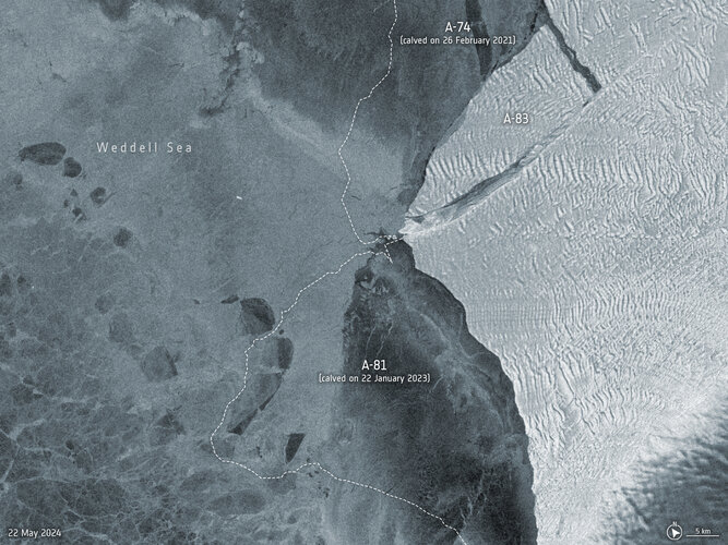 Image:
An iceberg roughly the size of the Isle of Wight has broken off the Brunt Ice Shelf in Antarctica on 20 May.
Image:
An iceberg roughly the size of the Isle of Wight has broken off the Brunt Ice Shelf in Antarctica on 20 May.
Zpřístupnění GP v Nahlížení KN pro geodety
23.5.2024 8:22 ČÚZK - RSS kanál pro zeměměřiče Upozorňujeme, že v rámci Nahlížení do KN pro geodety byla k možnosti stažení souborů ZPMZ nově doplněna rovněž možnost stažení souborů geometrických plánů. Jedná se o prosté kopie geometrických plánů (bez autentizačních prvků) poskytované výhradně odborně způsobilým osobám v režimu podkladů pro vyhotovení geometrického plánu nebo vytyčení hranice pozemků podle katastrální vyhlášky.Zpřístupnění GP v Nahlížení KN pro geodety
23.5.2024 8:22 ČÚZK /Zememerictvi/Zememericke-cinnosti/Aktuality-pro-zememerice/2024/Zpristupneni-GP-v-Nahlizeni-KN-pro-geodetyZpřístupnění GP v Nahlížení KN pro geodety
23.5.2024 8:22 ČÚZK - předpisy a opatření Český úřad zeměměřický a katastrálnízveřejnil novou aktualitu: Upozorňujeme, že v rámci Nahlížení do KN pro geodety byla k možnosti stažení souborů ZPMZ nově doplněna rovněž možnost stažení souborů geometrických plánů. Jedná se o prosté kopie geometrických plánů (bez autentizačních prvků) poskytované výhradně odborně způsobilým osobám v režimu podkladů pro vyhotovení geometrického plánu nebo vytyčení hranice pozemků podle katastrální vyhlášky.
Zpřístupnění GP v Nahlížení KN pro geodety
23.5.2024 8:22 ČÚZK - RSS kanál pro zeměměřiče Upozorňujeme, že v rámci Nahlížení do KN pro geodety byla k možnosti stažení souborů ZPMZ nově doplněna rovněž možnost stažení souborů geometrických plánů. Jedná se o prosté kopie geometrických plánů (bez autentizačních prvků) poskytované výhradně odborně způsobilým osobám v režimu podkladů pro vyhotovení geometrického plánu nebo vytyčení hranice pozemků podle katastrální vyhlášky.Airbus to build ESA’s Vigil space weather forecasting mission
22.5.2024 17:26 ESA Observing the Earth
Watch EarthCARE launch live
22.5.2024 13:05 ESA Observing the Earth
ESA’s Earth Cloud Aerosol and Radiation Explorer (EarthCARE) mission is getting ready for lift-off on a SpaceX Falcon 9 from Vandenberg, California, with a target launch date of no earlier than 28 May 2024. Save the date and watch the launch live on ESA WebTV or ESA YouTube.
Fireball witnessed by weather satellite
22.5.2024 10:39 ESA Observing the Earth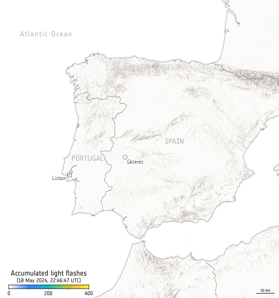
While a meteor lit up the skies over Spain and Portugal recently, it was also captured by the Meteosat Third Generation Imager weather satellite hovering 36,000 km away in geostationary orbit.
Ve Zlíně se otevírá nové Muzeum map
22.5.2024 8:46 Česká kartografická společnostV úterý 28. května 2024 v 10:00 proběhne ve Zlíně na ulici Vodní 1972 slavnostní otevření Muzea map. Jeho cílem je seznámit veřejnost s výjimečností kartografie a zároveň podpořit rozvoj cestovního ruchu v kraji. Těšit se můžete na historické zajímavosti i spoustu interaktivních prvků. Za zrodem muzea, které je svým zaměřením v Evropě poněkud netradiční, […]
The post Ve Zlíně se otevírá nové Muzeum map first appeared on Česká kartografická společnost.
Studenti předmětu Dějiny světové kartografie v mapových sbírkách [Katedra aplikované geoinformatiky a kartografie, byTopic]
21.5.2024 18:45 Katedra aplikované geoinformatiky a kartografie Přf UK V rámci předmětu Dějiny světové kartografie absolvovali studenti v letním semestru 2024 tři exkurze. Dvakrát navštívili Mapovou sbírku PřF UK a jednou Ústřední archiv zeměměřictví a katastru ČÚZK.EarthCARE pre-launch press briefing
21.5.2024 18:00 ESA Observing the Earth Video:
00:51:05
Video:
00:51:05
ESA’s Earth Cloud Aerosol and Radiation Explorer (EarthCARE) mission is designed to advance our understanding of the role that clouds and aerosols play in reflecting incident solar radiation back out to space and trapping infrared radiation emitted from Earth’s surface.
Developed as a cooperation between ESA and the Japan Aerospace Exploration Agency (JAXA), this exciting mission will make a range of different measurements that together will shed new light on the role that clouds and aerosols play in regulating Earth’s delicate temperature balance.
With global climate change increasingly affecting our planet, EarthCARE is poised to provide data for climate research, improve the accuracy of climate models and support numerical weather prediction.
The EarthCare pre-launch press briefing featured: Simonetta Cheli, Director of Earth Observation Programmes, ESA, Dirk Bernaerts, EarthCARE project manager and Acting Head Earth Explorers Division, ESA, Futoshi Takiguchi, Vice President and Director General for the Space Technology Directorate, JAXA, Eiichi Tomita, EarthCARE/CPR Project Manager, JAXA and Maximilian Sauer, EarthCARE Project Manager, Airbus.
odborný/vrchní referent – poskytování informací KN (nahlížení, opisy, kopie)
21.5.2024 15:58 ČÚZK /Urady/Katastralni-urady/Katastralni-urady/Katastralni-urad-pro-hlavni-mesto-Prahu/O-uradu/Aktuality/odborny-vrchni-referent-–-poskytovani-informaci-KNodborný/vrchní referent – poskytování informací KN (nahlížení, opisy, kopie)
21.5.2024 15:58 ČÚZK - předpisy a opatření Katastrální úřad pro hlavní město Prahu zveřejnil novou aktualitu: Ředitelka úřadu vyhlašuje výběrové řízení na pozici:odborný/vrchní referent – poskytování informací KN (nahlížení, opisy, kopie)
odborný/vrchní referent – poskytování informací KN (nahlížení, opisy, kopie)
21.5.2024 15:56 ČÚZK - volná místa Katastrální úřad pro hlavní město Prahu vypisuje výběrové řízení na místo odborný/vrchní referent – poskytování informací KN (nahlížení, opisy, kopie)odborný/vrchní referent – poskytování informací KN (nahlížení, opisy, kopie)
21.5.2024 15:56 ČÚZK - předpisy a opatření Katastrální úřad pro hlavní město Prahuvypisuje výběrové řízení na místo
odborný/vrchní referent – poskytování informací KN (nahlížení, opisy, kopie)
odborný/vrchní referent – poskytování informací KN (nahlížení, opisy, kopie)
21.5.2024 15:56 ČÚZK /Urady/Katastralni-urady/Katastralni-urady/Katastralni-urad-pro-hlavni-mesto-Prahu/Uredni-deska/Oznameni-a-jina-uredni-sdeleni/Volna-mista/odborny-vrchni-referent-–-poskytovani-informaci-KN20240521-VŘ Metodik bezpečnosti
21.5.2024 15:13 ČÚZK - předpisy a opatření Český úřad zeměměřický a katastrální zveřejnil novou aktualitu: Oznámení o vyhlášení výběrového řízení na obsazení služebního místa odborný rada - Metodik/metodička bezpečnosti.20240521-VŘ Metodik bezpečnosti
21.5.2024 15:13 ČÚZK - aktuality v resortu Oznámení o vyhlášení výběrového řízení na obsazení služebního místa odborný rada - Metodik/metodička bezpečnosti.20240521-VŘ Metodik bezpečnosti
21.5.2024 15:13 ČÚZK /Aktuality-resort/2024/20240521-VR-Metodik-bezpecnostiGeoKARTO 2024
21.5.2024 14:04 Komora geodetů a kartografů SRThe post GeoKARTO 2024 appeared first on Komora geodetov a kartografov.
Krátka správa č. 22/2024
21.5.2024 13:56 Komora geodetů a kartografů SRThe post Krátka správa č. 22/2024 appeared first on Komora geodetov a kartografov.
odborný referent / vrchní referent – obnova katastrálního operátu
21.5.2024 13:42 ČÚZK - volná místa Katastrální úřad pro Olomoucký kraj Katastrální pracoviště Přerov vypisuje výběrové řízení na místo odborný referent / vrchní referent – obnova katastrálního operátuodborný referent / vrchní referent – obnova katastrálního operátu
21.5.2024 13:42 ČÚZK - předpisy a opatření Katastrální úřad pro Olomoucký kraj Katastrální pracoviště Přerovvypisuje výběrové řízení na místo
odborný referent / vrchní referent – obnova katastrálního operátu
GIS Trainee & GIS Developer ve Stora Enso
21.5.2024 12:20 Katedra geoinformatiky UP OlomoucHledáme kolegu do společnosti Stora Enso na pozici GIS Trainee. Prvním úkolem této pozice je sběr a analýza trénovacích dat pro vývoj modelů hlubokého učení ze satelitních a dronových snímků, vhodné i jako letní brigáda. Náplň práce zahrnuje identifikaci stromů na snímcích, jejich přesnou anotaci a přípravu dat pro další zpracování. Součástí Vaší budoucí pozice […]
The post GIS Trainee & GIS Developer ve Stora Enso first appeared on Katedra geoinformatiky.
Vrchní referent/rada – kontrola aktualizace
21.5.2024 11:00 ČÚZK - předpisy a opatření Katastrální úřad pro Moravskoslezský kraj Katastrální pracoviště Karvinávypisuje výběrové řízení na místo
Vrchní referent/rada – kontrola aktualizace
Vrchní referent/rada – kontrola aktualizace
21.5.2024 11:00 ČÚZK - volná místa Katastrální úřad pro Moravskoslezský kraj Katastrální pracoviště Karviná vypisuje výběrové řízení na místo Vrchní referent/rada – kontrola aktualizaceVrchní referent/rada – kontrola aktualizace
21.5.2024 11:00 ČÚZK /Urady/Katastralni-urady/Katastralni-urady/Katastralni-urad-pro-Moravskoslezsky-kraj/Uredni-deska/Oznameni-a-jina-uredni-sdeleni/Volna-mista/DMS/Vrchni-referent-rada-–-kontrola-aktualizace20240521-VŘ - KP Bruntál
21.5.2024 8:44 ČÚZK - aktuality v resortu Oznámení o vyhlášení výběrových řízení na obsazení služebních míst ředitele/ředitelky Katastrálního pracoviště Krnov a Katastrálního pracoviště Bruntál.20240521-VŘ - KP Bruntál
21.5.2024 8:44 ČÚZK - předpisy a opatření Český úřad zeměměřický a katastrální zveřejnil novou aktualitu: Oznámení o vyhlášení výběrových řízení na obsazení služebních míst ředitele/ředitelky Katastrálního pracoviště Krnov a Katastrálního pracoviště Bruntál.20240520_odborný rada v oddělení aktualizace KN
20.5.2024 13:01 ČÚZK - předpisy a opatření Katastrální úřad pro Středočeský kraj - Katastrální pracoviště Benešov Vyhlášení výběrového řízení: odborný rada v oddělení aktualizace KN V části "Úřední deska", v sekci "Oznámení a jiná úřední sdělení" bylo vystaveno "Oznámení o vyhlášení výběrového řízení na obsazení služebního místa Odborný referent oddělení aktualizace KN"20240520_odborný rada v oddělení aktualizace KN
20.5.2024 13:01 ČÚZK /Urady/Katastralni-urady/Katastralni-urady/Katastralni-urad-pro-Stredocesky-kraj/Katastralni-pracoviste/KP-Benesov/O-uradu/Aktuality/20210922_Odborny-referent-oddeleni-aktualizace-(2)Data visualization | Romania city view by Lixel X1
20.5.2024 12:41 Satlab Geosolutions
The post Data visualization | Romania city view by Lixel X1 appeared first on Global Satellite Positioning Solutions | SatLab Geosolutions AB.
Data visualization | Romania city view by Lixel X1
20.5.2024 12:29 Satlab Geosolutions
The post Data visualization | Romania city view by Lixel X1 appeared first on Global Satellite Positioning Solutions | SatLab Geosolutions AB.
Satsurv Surveying Software Update | What’s new in V3.1.0?
20.5.2024 12:27 Satlab GeosolutionsThe post Satsurv Surveying Software Update | What’s new in V3.1.0? appeared first on Global Satellite Positioning Solutions | SatLab Geosolutions AB.
Quick Start Guide | Install APUS UAV LIDAR on DJI M300 in under 5 Minutes!
20.5.2024 12:22 Satlab Geosolutions
The post Quick Start Guide | Install APUS UAV LIDAR on DJI M300 in under 5 Minutes! appeared first on Global Satellite Positioning Solutions | SatLab Geosolutions AB.
Sat-Live Day | HydroBoat 1200 in Hong Kong
20.5.2024 12:16 Satlab Geosolutions
The post Sat-Live Day | HydroBoat 1200 in Hong Kong appeared first on Global Satellite Positioning Solutions | SatLab Geosolutions AB.
Partner Success Studies | SLAM to BIM Solution
20.5.2024 12:13 Satlab Geosolutions
The post Partner Success Studies | SLAM to BIM Solution appeared first on Global Satellite Positioning Solutions | SatLab Geosolutions AB.
APUS UAV LiDAR System | Beyond Boundaries
20.5.2024 12:11 Satlab Geosolutions
The post APUS UAV LiDAR System | Beyond Boundaries appeared first on Global Satellite Positioning Solutions | SatLab Geosolutions AB.
Apus UAV LiDAR System | Beyond Boundaries
20.5.2024 12:11 Satlab Geosolutions
The post Apus UAV LiDAR System | Beyond Boundaries appeared first on Global Satellite Positioning Solutions | SatLab Geosolutions AB.
[Webinar] – APUS UAV LiDAR Overview | Beyond Boundaries
20.5.2024 12:09 Satlab Geosolutions
The post [Webinar] – APUS UAV LiDAR Overview | Beyond Boundaries appeared first on Global Satellite Positioning Solutions | SatLab Geosolutions AB.
[Webinar] – Apus UAV LiDAR Overview | Beyond Boundaries
20.5.2024 12:09 Satlab Geosolutions
The post [Webinar] – Apus UAV LiDAR Overview | Beyond Boundaries appeared first on Global Satellite Positioning Solutions | SatLab Geosolutions AB.
Office & Factory Tour | Geosolution i Göteborg AB
20.5.2024 12:06 Satlab Geosolutions
The post Office & Factory Tour | Geosolution i Göteborg AB appeared first on Global Satellite Positioning Solutions | SatLab Geosolutions AB.
Saloma Link Bridge point cloud by Lixel X1 LiDAR scanner
20.5.2024 12:00 Satlab Geosolutions
The post Saloma Link Bridge point cloud by Lixel X1 LiDAR scanner appeared first on Global Satellite Positioning Solutions | SatLab Geosolutions AB.
Data visualization – energy transmission lines inspection
20.5.2024 11:57 Satlab Geosolutions
The post Data visualization – energy transmission lines inspection appeared first on Global Satellite Positioning Solutions | SatLab Geosolutions AB.
Unboxing – Lixel X1 SLAM Scanner
20.5.2024 11:55 Satlab Geosolutions
The post Unboxing – Lixel X1 SLAM Scanner appeared first on Global Satellite Positioning Solutions | SatLab Geosolutions AB.
Industrial zone point cloud by drone-mounted Lixel X1 LiDAR scanner
20.5.2024 11:44 Satlab Geosolutions
The post Industrial zone point cloud by drone-mounted Lixel X1 LiDAR scanner appeared first on Global Satellite Positioning Solutions | SatLab Geosolutions AB.
Data Visualization of Mexico Street – Lixel X1 SLAM scanner
20.5.2024 11:39 Satlab Geosolutions
The post Data Visualization of Mexico Street – Lixel X1 SLAM scanner appeared first on Global Satellite Positioning Solutions | SatLab Geosolutions AB.
Data visualization | Romania city view by Lixel X1 SLAM SCANNER
20.5.2024 11:05 Satlab Geosolutions
The post Data visualization | Romania city view by Lixel X1 SLAM SCANNER appeared first on Global Satellite Positioning Solutions | SatLab Geosolutions AB.
Point Cloud Data Visualization | Cygnus SLAM scanner
20.5.2024 11:05 Satlab Geosolutions
The post Point Cloud Data Visualization | Cygnus SLAM scanner appeared first on Global Satellite Positioning Solutions | SatLab Geosolutions AB.
Partner Success Studies | SLAM to BIM Solution – LiXEL X1 SLAM SCANNER
20.5.2024 11:00 Satlab Geosolutions
The post Partner Success Studies | SLAM to BIM Solution – LiXEL X1 SLAM SCANNER appeared first on Global Satellite Positioning Solutions | SatLab Geosolutions AB.
Rada/odborný rada v oddělení podpory informačních a komunikačních technologií na Technické sekci
20.5.2024 10:57 ČÚZK - předpisy a opatření Katastrální úřad pro Jihomoravský kraj technická sekcevypisuje výběrové řízení na místo
Rada/odborný rada v oddělení podpory informačních a komunikačních technologií na Technické sekci
Rada/odborný rada v oddělení podpory informačních a komunikačních technologií na Technické sekci
20.5.2024 10:57 ČÚZK /Urady/Katastralni-urady/Katastralni-urady/Katastralni-urad-pro-Jihomoravsky-kraj/Uredni-deska/Oznameni-a-jina-uredni-sdeleni/Volna-mista/DMS/Rada-odborny-rada-v-oddeleni-podpory-informacnich-Rada/odborný rada v oddělení podpory informačních a komunikačních technologií na Technické sekci
20.5.2024 10:57 ČÚZK - volná místa Katastrální úřad pro Jihomoravský kraj technická sekce vypisuje výběrové řízení na místo Rada/odborný rada v oddělení podpory informačních a komunikačních technologií na Technické sekciOdborný referent v oddělení právních vztahů k nemovitostem na Katastrálním pracovišti Znojmo
20.5.2024 10:54 ČÚZK - volná místa Katastrální úřad pro Jihomoravský kraj Katastrální pracoviště Znojmo vypisuje výběrové řízení na místo Odborný referent v oddělení právních vztahů k nemovitostem na Katastrálním pracovišti ZnojmoOdborný referent v oddělení právních vztahů k nemovitostem na Katastrálním pracovišti Znojmo
20.5.2024 10:54 ČÚZK /Urady/Katastralni-urady/Katastralni-urady/Katastralni-urad-pro-Jihomoravsky-kraj/Uredni-deska/Oznameni-a-jina-uredni-sdeleni/Volna-mista/DMS/Odborny-referent-v-oddeleni-pravnich-vztahu-k-(1)Odborný referent v oddělení právních vztahů k nemovitostem na Katastrálním pracovišti Znojmo
20.5.2024 10:54 ČÚZK - předpisy a opatření Katastrální úřad pro Jihomoravský kraj Katastrální pracoviště Znojmovypisuje výběrové řízení na místo
Odborný referent v oddělení právních vztahů k nemovitostem na Katastrálním pracovišti Znojmo
Vrchní referent/rada – obnova katastrálního operátu v oddělení aktualizace a dokumentace KN Katastr
20.5.2024 9:43 ČÚZK /Urady/Katastralni-urady/Katastralni-urady/Katastralni-urad-pro-Moravskoslezsky-kraj/Uredni-deska/Oznameni-a-jina-uredni-sdeleni/Volna-mista/DMS/Vrchni-referent-rada-–-obnova-katastralniho-op-(3)Vrchní referent/rada – obnova katastrálního operátu v oddělení aktualizace a dokumentace KN Katastr
20.5.2024 9:43 ČÚZK - volná místa Katastrální úřad pro Moravskoslezský kraj Katastrální pracoviště Třinec vypisuje výběrové řízení na místo Vrchní referent/rada – obnova katastrálního operátu v oddělení aktualizace a dokumentace KN KatastrVrchní referent/rada – obnova katastrálního operátu v oddělení aktualizace a dokumentace KN Katastr
20.5.2024 9:43 ČÚZK - předpisy a opatření Katastrální úřad pro Moravskoslezský kraj Katastrální pracoviště Třinecvypisuje výběrové řízení na místo
Vrchní referent/rada – obnova katastrálního operátu v oddělení aktualizace a dokumentace KN Katastrálního úřadu pro Moravskoslezský kraj, Katastrálního pracoviště Třinec
Odborný referent/vrchní referent – vedení katastrální mapy v oddělení aktualizace a dokumentace KN K
20.5.2024 9:36 ČÚZK /Urady/Katastralni-urady/Katastralni-urady/Katastralni-urad-pro-Moravskoslezsky-kraj/Uredni-deska/Oznameni-a-jina-uredni-sdeleni/Volna-mista/DMS/Odborny-referent-vrchni-referent-–-vedeni-katastraOdborný referent/vrchní referent – vedení katastrální mapy v oddělení aktualizace a dokumentace KN K
20.5.2024 9:36 ČÚZK - volná místa Katastrální úřad pro Moravskoslezský kraj Katastrální pracoviště Karviná vypisuje výběrové řízení na místo Odborný referent/vrchní referent – vedení katastrální mapy v oddělení aktualizace a dokumentace KN KOdborný referent/vrchní referent – vedení katastrální mapy v oddělení aktualizace a dokumentace KN K
20.5.2024 9:36 ČÚZK - předpisy a opatření Katastrální úřad pro Moravskoslezský kraj Katastrální pracoviště Karvinávypisuje výběrové řízení na místo
Odborný referent/vrchní referent – vedení katastrální mapy v oddělení aktualizace a dokumentace KN Katastrálního úřadu pro Moravskoslezský kraj, Katastrálního pracoviště Karviná
Rada/odborný rada – obnova katastrálního operátu v oddělení aktualizace KN Katastrálního úřadu pro M
20.5.2024 9:30 ČÚZK - volná místa Katastrální úřad pro Moravskoslezský kraj Katastrální pracoviště Frýdek-Místek vypisuje výběrové řízení na místo Rada/odborný rada – obnova katastrálního operátu v oddělení aktualizace KN Katastrálního úřadu pro MRada/odborný rada – obnova katastrálního operátu v oddělení aktualizace KN Katastrálního úřadu pro M
20.5.2024 9:30 ČÚZK /Urady/Katastralni-urady/Katastralni-urady/Katastralni-urad-pro-Moravskoslezsky-kraj/Uredni-deska/Oznameni-a-jina-uredni-sdeleni/Volna-mista/DMS/Rada-odborny-rada-–-obnova-katastralniho-operatu-vRada/odborný rada – obnova katastrálního operátu v oddělení aktualizace KN Katastrálního úřadu pro M
20.5.2024 9:30 ČÚZK - předpisy a opatření Katastrální úřad pro Moravskoslezský kraj Katastrální pracoviště Frýdek-Místekvypisuje výběrové řízení na místo
Rada/odborný rada – obnova katastrálního operátu v oddělení aktualizace KN Katastrálního úřadu pro Moravskoslezský kraj, Katastrálního pracoviště Frýdek-Místek
Rada/odborný rada – řízení o opravě chyby SPI v oddělení dokumentace KN Katastrálního úřadu pro Mora
20.5.2024 9:26 ČÚZK - předpisy a opatření Katastrální úřad pro Moravskoslezský kraj Katastrální pracoviště Frýdek-Místekvypisuje výběrové řízení na místo
Rada/odborný rada – řízení o opravě chyby SPI v oddělení dokumentace KN Katastrálního úřadu pro Moravskoslezský kraj, Katastrálního pracoviště Frýdek-Místek
Rada/odborný rada – řízení o opravě chyby SPI v oddělení dokumentace KN Katastrálního úřadu pro Mora
20.5.2024 9:26 ČÚZK /Urady/Katastralni-urady/Katastralni-urady/Katastralni-urad-pro-Moravskoslezsky-kraj/Uredni-deska/Oznameni-a-jina-uredni-sdeleni/Volna-mista/DMS/Rada-odborny-rada-–-rizeni-o-oprave-chyby-SPI-v-odRada/odborný rada – řízení o opravě chyby SPI v oddělení dokumentace KN Katastrálního úřadu pro Mora
20.5.2024 9:26 ČÚZK - volná místa Katastrální úřad pro Moravskoslezský kraj Katastrální pracoviště Frýdek-Místek vypisuje výběrové řízení na místo Rada/odborný rada – řízení o opravě chyby SPI v oddělení dokumentace KN Katastrálního úřadu pro MoraVrchní referent/rada – obnova katastrálního operátu, Katastrální úřad pro Moravskoslezský kraj v odd
20.5.2024 9:23 ČÚZK - volná místa Katastrální úřad pro Moravskoslezský kraj Katastrální pracoviště Bruntál vypisuje výběrové řízení na místo Vrchní referent/rada – obnova katastrálního operátu, Katastrální úřad pro Moravskoslezský kraj v oddVrchní referent/rada – obnova katastrálního operátu, Katastrální úřad pro Moravskoslezský kraj v odd
20.5.2024 9:23 ČÚZK - předpisy a opatření Katastrální úřad pro Moravskoslezský kraj Katastrální pracoviště Bruntálvypisuje výběrové řízení na místo
Vrchní referent/rada – obnova katastrálního operátu, Katastrální úřad pro Moravskoslezský kraj v oddělení aktualizace a dokumentace KN, Katastrální pracoviště Bruntál
Vrchní referent/rada – obnova katastrálního operátu, Katastrální úřad pro Moravskoslezský kraj v odd
20.5.2024 9:23 ČÚZK /Urady/Katastralni-urady/Katastralni-urady/Katastralni-urad-pro-Moravskoslezsky-kraj/Uredni-deska/Oznameni-a-jina-uredni-sdeleni/Volna-mista/DMS/Vrchni-referent-rada-–-obnova-katastralniho-op-(2)Rada/odborný rada – správce informačních a komunikačních technologií v oddělení podpory ICT Katastr
20.5.2024 9:05 ČÚZK - předpisy a opatření Katastrální úřad pro Moravskoslezský kraj technický odborvypisuje výběrové řízení na místo
Rada/odborný rada – správce informačních a komunikačních technologií v oddělení podpory ICT Katastrálního úřadu pro Moravskoslezský kraj, v technickém odboru
Rada/odborný rada – správce informačních a komunikačních technologií v oddělení podpory ICT Katastr
20.5.2024 9:05 ČÚZK /Urady/Katastralni-urady/Katastralni-urady/Katastralni-urad-pro-Moravskoslezsky-kraj/Uredni-deska/Oznameni-a-jina-uredni-sdeleni/Volna-mista/DMS/Rada-odborny-rada-–-spravce-informacnich-a-komunikRada/odborný rada – správce informačních a komunikačních technologií v oddělení podpory ICT Katastr
20.5.2024 9:05 ČÚZK - volná místa Katastrální úřad pro Moravskoslezský kraj technický odbor vypisuje výběrové řízení na místo Rada/odborný rada – správce informačních a komunikačních technologií v oddělení podpory ICT KatastrOdborný referent/vrchní referent – obnova katastrálního operátu v oddělení obnovy katastrálního oper
20.5.2024 9:01 ČÚZK - předpisy a opatření Katastrální úřad pro Moravskoslezský kraj technický odborvypisuje výběrové řízení na místo
Odborný referent/vrchní referent – obnova katastrálního operátu v oddělení obnovy katastrálního operátu 1 Katastrálního úřadu pro Moravskoslezský kraj, v technickém odboru
Odborný referent/vrchní referent – obnova katastrálního operátu v oddělení obnovy katastrálního oper
20.5.2024 9:01 ČÚZK /Urady/Katastralni-urady/Katastralni-urady/Katastralni-urad-pro-Moravskoslezsky-kraj/Uredni-deska/Oznameni-a-jina-uredni-sdeleni/Volna-mista/DMS/Odborny-referent-vrchni-referent-–-obnova-kata-(1)Odborný referent/vrchní referent – obnova katastrálního operátu v oddělení obnovy katastrálního oper
20.5.2024 9:01 ČÚZK - volná místa Katastrální úřad pro Moravskoslezský kraj technický odbor vypisuje výběrové řízení na místo Odborný referent/vrchní referent – obnova katastrálního operátu v oddělení obnovy katastrálního operVrchní referent/rada – obnova katastrálního operátu v oddělení obnovy katastrálního operátu 3 Katas
20.5.2024 8:59 ČÚZK /Urady/Katastralni-urady/Katastralni-urady/Katastralni-urad-pro-Moravskoslezsky-kraj/Uredni-deska/Oznameni-a-jina-uredni-sdeleni/Volna-mista/DMS/Vrchni-referent-rada-–-obnova-katastralniho-op-(1)Vrchní referent/rada – obnova katastrálního operátu v oddělení obnovy katastrálního operátu 3 Katas
20.5.2024 8:59 ČÚZK - volná místa Katastrální úřad pro Moravskoslezský kraj technický odbor vypisuje výběrové řízení na místo Vrchní referent/rada – obnova katastrálního operátu v oddělení obnovy katastrálního operátu 3 KatasVrchní referent/rada – obnova katastrálního operátu v oddělení obnovy katastrálního operátu 3 Katas
20.5.2024 8:59 ČÚZK - předpisy a opatření Katastrální úřad pro Moravskoslezský kraj technický odborvypisuje výběrové řízení na místo
Vrchní referent/rada – obnova katastrálního operátu v oddělení obnovy katastrálního operátu 3 Katastrálního úřadu pro Moravskoslezský kraj, v technickém odboru
Odborný referent/vrchní referent – obnova katastrálního operátu v oddělení obnovy katastrálního ope
20.5.2024 8:56 ČÚZK - předpisy a opatření Katastrální úřad pro Moravskoslezský kraj technický odborvypisuje výběrové řízení na místo
Odborný referent/vrchní referent – obnova katastrálního operátu v oddělení obnovy katastrálního operátu 2 a bodových polí Katastrálního úřadu pro Moravskoslezský kraj, v technickém odboru
Odborný referent/vrchní referent – obnova katastrálního operátu v oddělení obnovy katastrálního ope
20.5.2024 8:56 ČÚZK - volná místa Katastrální úřad pro Moravskoslezský kraj technický odbor vypisuje výběrové řízení na místo Odborný referent/vrchní referent – obnova katastrálního operátu v oddělení obnovy katastrálního opeOdborný referent/vrchní referent – obnova katastrálního operátu v oddělení obnovy katastrálního ope
20.5.2024 8:56 ČÚZK /Urady/Katastralni-urady/Katastralni-urady/Katastralni-urad-pro-Moravskoslezsky-kraj/Uredni-deska/Oznameni-a-jina-uredni-sdeleni/Volna-mista/DMS/Odborny-referent-vrchni-referent-–-obnova-katastraVrchní referent/rada – obnova katastrálního operátu v oddělení obnovy katastrálního operátu 1 Katas
20.5.2024 8:52 ČÚZK /Urady/Katastralni-urady/Katastralni-urady/Katastralni-urad-pro-Moravskoslezsky-kraj/Uredni-deska/Oznameni-a-jina-uredni-sdeleni/Volna-mista/DMS/Vrchni-referent-rada-–-obnova-katastralniho-operatVrchní referent/rada – obnova katastrálního operátu v oddělení obnovy katastrálního operátu 1 Katas
20.5.2024 8:52 ČÚZK - volná místa Katastrální úřad pro Moravskoslezský kraj technický odbor vypisuje výběrové řízení na místo Vrchní referent/rada – obnova katastrálního operátu v oddělení obnovy katastrálního operátu 1 KatasVrchní referent/rada – obnova katastrálního operátu v oddělení obnovy katastrálního operátu 1 Katas
20.5.2024 8:52 ČÚZK - předpisy a opatření Katastrální úřad pro Moravskoslezský kraj technický odborvypisuje výběrové řízení na místo
Vrchní referent/rada – obnova katastrálního operátu v oddělení obnovy katastrálního operátu 1 Katastrálního úřadu pro Moravskoslezský kraj, v technickém odboru
Rada/odborný rada – ředitel/ka odboru Katastrální pracoviště Krnov Katastrálního úřadu pro Moravsko
20.5.2024 8:49 ČÚZK /Urady/Katastralni-urady/Katastralni-urady/Katastralni-urad-pro-Moravskoslezsky-kraj/Uredni-deska/Oznameni-a-jina-uredni-sdeleni/Volna-mista/DMS/Rada-odborny-rada-–-reditel-ka-odboru-Katastra-(1)Rada/odborný rada – ředitel/ka odboru Katastrální pracoviště Krnov Katastrálního úřadu pro Moravsko
20.5.2024 8:49 ČÚZK - volná místa Katastrální úřad pro Moravskoslezský kraj Katastrální pracoviště Krnov vypisuje výběrové řízení na místo Rada/odborný rada – ředitel/ka odboru Katastrální pracoviště Krnov Katastrálního úřadu pro MoravskoRada/odborný rada – ředitel/ka odboru Katastrální pracoviště Krnov Katastrálního úřadu pro Moravsko
20.5.2024 8:49 ČÚZK - předpisy a opatření Katastrální úřad pro Moravskoslezský kraj Katastrální pracoviště Krnovvypisuje výběrové řízení na místo
Rada/odborný rada – ředitel/ka odboru Katastrální pracoviště Krnov Katastrálního úřadu pro Moravskoslezský kraj, Katastrální pracoviště Krnov
Rada/odborný rada – ředitel/ka odboru Katastrální pracoviště Bruntál Katastrálního úřadu pro Moravs
20.5.2024 8:46 ČÚZK - volná místa Katastrální úřad pro Moravskoslezský kraj Katastrální pracoviště Bruntál vypisuje výběrové řízení na místo Rada/odborný rada – ředitel/ka odboru Katastrální pracoviště Bruntál Katastrálního úřadu pro MoravsRada/odborný rada – ředitel/ka odboru Katastrální pracoviště Bruntál Katastrálního úřadu pro Moravs
20.5.2024 8:46 ČÚZK /Urady/Katastralni-urady/Katastralni-urady/Katastralni-urad-pro-Moravskoslezsky-kraj/Uredni-deska/Oznameni-a-jina-uredni-sdeleni/Volna-mista/DMS/Rada-odborny-rada-–-reditel-ka-odboru-Katastralni-Rada/odborný rada – ředitel/ka odboru Katastrální pracoviště Bruntál Katastrálního úřadu pro Moravs
20.5.2024 8:46 ČÚZK - předpisy a opatření Katastrální úřad pro Moravskoslezský kraj Katastrální pracoviště Bruntálvypisuje výběrové řízení na místo
Rada/odborný rada – ředitel/ka odboru Katastrální pracoviště Bruntál Katastrálního úřadu pro Moravskoslezský kraj, Katastrální pracoviště Bruntál
Rada/odborný rada – ředitel/ka odboru kancelář ředitele Katastrálního úřadu pro Moravskoslezský kra
20.5.2024 8:37 ČÚZK - předpisy a opatření Katastrální úřad pro Moravskoslezský kraj - kancelář ředitelevypisuje výběrové řízení na místo
Rada/odborný rada – ředitel/ka odboru kancelář ředitele Katastrálního úřadu pro Moravskoslezský kraj
Rada/odborný rada – ředitel/ka odboru kancelář ředitele Katastrálního úřadu pro Moravskoslezský kra
20.5.2024 8:37 ČÚZK - předpisy a opatření Katastrální úřad pro Moravskoslezský kraj kancelář ředitelevypisuje výběrové řízení na místo
Rada/odborný rada – ředitel/ka odboru kancelář ředitele Katastrálního úřadu pro Moravskoslezský kraj
Rada/odborný rada – ředitel/ka odboru kancelář ředitele Katastrálního úřadu pro Moravskoslezský kra
20.5.2024 8:37 ČÚZK /Urady/Katastralni-urady/Katastralni-urady/Katastralni-urad-pro-Moravskoslezsky-kraj/Uredni-deska/Oznameni-a-jina-uredni-sdeleni/Volna-mista/DMS/Rada-odborny-rada-–-reditel-ka-odboru-kancelar-redRada/odborný rada – ředitel/ka odboru kancelář ředitele Katastrálního úřadu pro Moravskoslezský kra
20.5.2024 8:37 ČÚZK - volná místa Katastrální úřad pro Moravskoslezský kraj - kancelář ředitele vypisuje výběrové řízení na místo Rada/odborný rada – ředitel/ka odboru kancelář ředitele Katastrálního úřadu pro Moravskoslezský kraRada/odborný rada – ředitel/ka odboru kancelář ředitele Katastrálního úřadu pro Moravskoslezský kra
20.5.2024 8:37 ČÚZK - volná místa Katastrální úřad pro Moravskoslezský kraj kancelář ředitele vypisuje výběrové řízení na místo Rada/odborný rada – ředitel/ka odboru kancelář ředitele Katastrálního úřadu pro Moravskoslezský kraRada/odborný rada – vedoucí oddělení aktualizace KN Katastrálního úřadu pro Moravskoslezský kraj, K
20.5.2024 8:32 ČÚZK - volná místa Katastrální úřad pro Moravskoslezský kraj Katastrální pracoviště Frýdek-Místek vypisuje výběrové řízení na místo Rada/odborný rada – vedoucí oddělení aktualizace KN Katastrálního úřadu pro Moravskoslezský kraj, KRada/odborný rada – vedoucí oddělení aktualizace KN Katastrálního úřadu pro Moravskoslezský kraj, K
20.5.2024 8:32 ČÚZK /Urady/Katastralni-urady/Katastralni-urady/Katastralni-urad-pro-Moravskoslezsky-kraj/Uredni-deska/Oznameni-a-jina-uredni-sdeleni/Volna-mista/DMS/Rada-odborny-rada-–-vedouci-oddeleni-aktualizace-KRada/odborný rada – vedoucí oddělení aktualizace KN Katastrálního úřadu pro Moravskoslezský kraj, K
20.5.2024 8:32 ČÚZK - předpisy a opatření Katastrální úřad pro Moravskoslezský kraj Katastrální pracoviště Frýdek-Místekvypisuje výběrové řízení na místo
Rada/odborný rada – vedoucí oddělení aktualizace KN Katastrálního úřadu pro Moravskoslezský kraj, Katastrálního pracoviště Frýdek-Místek
Jarní webináře ArcGIS
20.5.2024 8:28 GISportal.cz
Společnost ARCDATA PRAHA zve na serii pěti nových webinářů o technologiích ArcGIS, které bude vysílat jednou týdně v průběhu května a června 2024. Účast na webinářích je zdarma, stačí se jen zaregistrovat. Součástí webináře bude také chat, kde se budete moci přednášejících (ale i ostatních posluchačů) na cokoliv zeptat. Záznamy webinářů z minulých ročníků můžete […]
The post Jarní webináře ArcGIS appeared first on GISportal.cz.
Jarní webináře ArcGIS
20.5.2024 8:28 GISportal.czSpolečnost ARCDATA PRAHA zve na serii pěti nových webinářů o technologiích ArcGIS, které bude vysílat jednou týdně v průběhu května a června 2024. Účast na webinářích je zdarma, stačí se jen zaregistrovat. Součástí webináře bude také chat, kde se budete moci přednášejících (ale i ostatních posluchačů) na cokoliv zeptat. Záznamy webinářů z minulých ročníků můžete […]
The post Jarní webináře ArcGIS appeared first on GISportal.cz.
Mezinárodní ocenění Best Map Award časopisu Journal of Maps opět míří do Olomouce
20.5.2024 8:15 GISportal.cz
Mezinárodní ocenění Best Map Award časopisu Journal of Maps letos opět míří do Olomouce a to hned třikrát. Každoročně uděluje časopis Journal of Maps ocenění „Best Map Award“. Letos tuto cenu získala Geologická mapa Jižní Ameriky na Google Maps, která nejenže sjednotila geologické mapy napříč jednotlivými zeměmi, ale také je zveřejnila online ve volně dostupném […]
The post Mezinárodní ocenění Best Map Award časopisu Journal of Maps opět míří do Olomouce appeared first on GISportal.cz.
STOP-STAV v k.ú. Horní Branná v rámci OKO novým mapováním na části k.ú.
20.5.2024 6:43 ČÚZK /Urady/Katastralni-urady/Katastralni-urady/Katastralni-urad-pro-Liberecky-kraj/Katastralni-pracoviste/KP-Semily/O-uradu/Aktuality/STOP-STAV-v k-u-Horni-Branna-v-ramci-OKO-novym-(1)STOP-STAV v k.ú. Horní Branná v rámci OKO novým mapováním na části k.ú.
20.5.2024 6:43 ČÚZK - předpisy a opatření Katastrální úřad pro Liberecký kraj - Katastrální pracoviště Semily zveřejnil novou aktualitu: Dnem 17. 5. 2024 byl vyhlášen STOP-STAV v k.ú. Horní Branná v rámci OKO novým mapováním na části k.ú. – lokalita Vejsplachy (parcely dotčené řízením OO-1/2023-608) pro zápisy listin do KN, rezervace ZPMZ a nových parcelních čísel do doby zplatnění obnoveného katastrálního operátu. Tímto STOP-STAVem jsou dotčeny také tyto parcely z k.ú. Vrchlabí – ppč. 605, 608/1, 608/2, 625/1, 625/3, 627/1, 627/2, 692/2 a 1918/1.Předpokládaný datum vyhlášení je 25. 6. 2024.
TurboCAD Platinum 28 CZ + přes 30 miliónů CAD Symbolů
19.5.2024 16:52 ŠPINAR - softwarePřipravili jsme pro Vás skvělé spojení TurboCAD Platinum + CAD Symbols v akční ceně do 26 5. 2024.
The post TurboCAD Platinum 28 CZ + přes 30 miliónů CAD Symbolů appeared first on ŠPINAR – software.
GISáček 2024 (výsledky)
18.5.2024 7:58 GISportal.cz
Ve středu 15. května proběhl 27. ročník studentské konference GISáček s tematickým zaměřením na oblast geoinformatiky a geoinformačních technologií, včetně jejich aplikací. Soutěže se zúčastnili studenti bakalářských i magisterských programů z Česka a Slovenka. Vítězům gratulujeme a doufáme, že se jim bude i nadále dařit! bakalářská kategorie 1. místo: Josef Zátka (UK Praha): Analýza dat […]
The post GISáček 2024 (výsledky) appeared first on GISportal.cz.