


Language


![]()

zprávy
zdroje zpráv:odborný/vrchní referent – zápis do protokolu V a Z
24.4.2024 16:02 ČÚZK /Urady/Katastralni-urady/Katastralni-urady/Katastralni-urad-pro-hlavni-mesto-Prahu/Uredni-deska/Oznameni-a-jina-uredni-sdeleni/Volna-mista/odborny-vrchni-referent-–-zapis-do-protokolu-V-(2)odborný/vrchní referent – zápis do protokolu V a Z
24.4.2024 16:02 ČÚZK - volná místa Katastrální úřad pro hlavní město Prahu vypisuje výběrové řízení na místo odborný/vrchní referent – zápis do protokolu V a Zodborný rada – rozhodování o povolení vkladu práv k nemovitostem do KN
24.4.2024 15:59 ČÚZK - předpisy a opatření Katastrální úřad pro hlavní město Prahuvypisuje výběrové řízení na místo
odborný rada – rozhodování o povolení vkladu práv k nemovitostem do KN
odborný rada – rozhodování o povolení vkladu práv k nemovitostem do KN
24.4.2024 15:59 ČÚZK /Urady/Katastralni-urady/Katastralni-urady/Katastralni-urad-pro-hlavni-mesto-Prahu/Uredni-deska/Oznameni-a-jina-uredni-sdeleni/Volna-mista/odborny-rada-–-rozhodovani-o-povoleni-vkladu-p-(1)odborný rada – rozhodování o povolení vkladu práv k nemovitostem do KN
24.4.2024 15:59 ČÚZK - volná místa Katastrální úřad pro hlavní město Prahu vypisuje výběrové řízení na místo odborný rada – rozhodování o povolení vkladu práv k nemovitostem do KNOznámení o vyhlášení VŘ na služební místo rada - odborný rada
24.4.2024 12:22 ČÚZK - předpisy a opatření Zeměměřický a katastrální inspektorát v Praze zveřejnil novou aktualitu: Zeměměřický a katastrální inspektorát v Praze vyhlašuje výběrová řízení na služební místa Rada/Odborný rada inspektor (obor služby 55).20240424_Odborný / vrchní referent oddělení právních vztahů k nemovitostem
24.4.2024 10:16 ČÚZK /Urady/Katastralni-urady/Katastralni-urady/Katastralni-urad-pro-Stredocesky-kraj/Katastralni-pracoviste/KP-Kladno/O-uradu/Aktuality/20210922_Odborny-referent-oddeleni-aktualizace-(3)20240424_Odborný / vrchní referent oddělení právních vztahů k nemovitostem
24.4.2024 10:16 ČÚZK - předpisy a opatření Katastrální úřad pro Středočeský kraj - Katastrální pracoviště Kladno Vyhlášení výběrového řízení: Odborný / vrchní referent oddělení právních vztahů k nemovitostem V části "Úřední deska", v sekci "Oznámení a jiná úřední sdělení" bylo vystaveno "Oznámení o vyhlášení výběrového řízení na obsazení služebního místa Odborný / vrchní referent oddělení právních vztahů k nemovitostem"Odborný / vrchní referent oddělení právních vztahů k nemovitostem
24.4.2024 9:56 ČÚZK - předpisy a opatření Katastrální úřad pro Středočeský kraj Katastrální pracoviště Kladnovypisuje výběrové řízení na místo
Odborný / vrchní referent oddělení právních vztahů k nemovitostem
Odborný / vrchní referent oddělení právních vztahů k nemovitostem
24.4.2024 9:56 ČÚZK - volná místa Katastrální úřad pro Středočeský kraj Katastrální pracoviště Kladno vypisuje výběrové řízení na místo Odborný / vrchní referent oddělení právních vztahů k nemovitostemFrom space to soil
24.4.2024 9:50 ESA Observing the Earth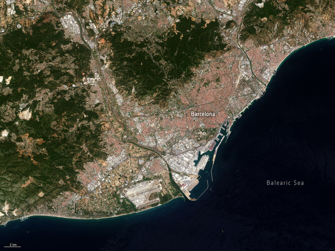
Soil sealing might not be a term that everyone's familiar with, but its effects are felt far and wide, particularly in urban areas.
Recognising the urgencies of addressing soil sealing and its associated challenges, an ESA-funded project, Ulysses, is offering insights into the extent and severity of soil sealing to mitigate soil degradation in the Mediterranean region.
Aktualizace služby WMTS ZABAGED® - polohopis
24.4.2024 9:08 ČÚZK - Geoportál Aktualizace služby WMTS ZABAGED® - polohopisProhlížecí služba z rastrových mapových dlaždic WMTS ZABAGED® - polohopis, již poskytuje veškeré změny po poslední pravidelné čtvrtletní aktualizaci dat. Služba byla vytvořena za účelem využití datové sady ZABAGED® - polohopis jako podkladové mapy s rychlým překreslováním. Přestože jde o dlaždicovou službu, poskytuje data ve více měřítkových řadách a souřadnicových systémech (definovaných v capabilities služby).
Již dříve (souběžně s aktualizací dat) byla aktualizována dynamická prohlížecí služba ZABAGED® - polohopis poskytující obraz dat přímo z publikační databáze, včetně možnosti vypínání vrstev, dotazů na atributy a stahování objektů ve formátu GeoJSON. Kromě této ArcGIS Rest služby je možné využít i rozhraní pro OGC služby: WMS (prohlížecí) a WFS (stahovací).
Svátek práce [Knihovna geografie, byTopic]
24.4.2024 8:20 Katedra aplikované geoinformatiky a kartografie Přf UK Ve středu 1. května bude Knihovna geografie ve státní svátek uzavřena.Nedostupné produkční ISÚI
23.4.2024 10:58 ČÚZK /ruian/Editacni-agendovy-system-ISUI/Provozni-informace-a-odstavky/Archiv-PROD/Nedostupne-produkcni-ISUI-(6)10 ways Earth is interconnected
22.4.2024 8:55 ESA Observing the Earth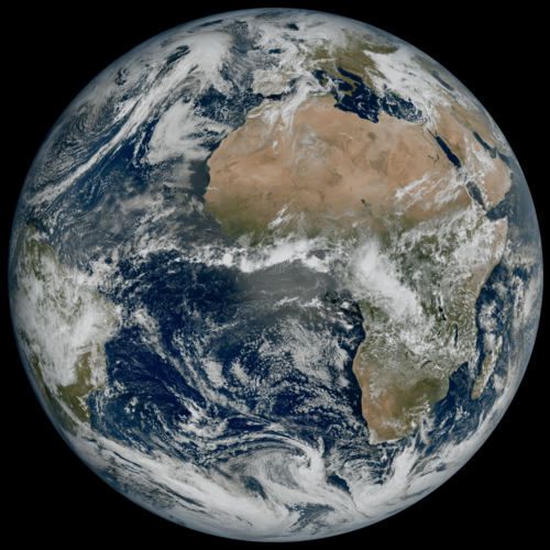
On this Earth Day, we reflect on the importance of protecting our planet for future generations. Understanding the Earth system and the complex interactions that shape our planet is paramount for addressing environmental challenges, mitigating climate change, preparing for natural disasters, managing resources sustainably and conserving biodiversity.
Each component of the Earth system – from the atmosphere and oceans to land surfaces and ice sheets – influences and interacts with one another in complex ways. ESA works all-year round to provide satellite data to monitor the health of our planet. Here are 10 examples of how Earth’s systems intertwine and how satellite measurements are key to understanding these complex processes.
20240422-VŘ KP Jeseník, KP Olomouc, KP Prostějov, KP Přerov, KP Šumperk
22.4.2024 6:55 ČÚZK - aktuality v resortu Oznámení o vyhlášení výběrových řízení na obsazení služebních míst ředitele/ředitelky Katastrálního pracoviště Jeseník, Katastrálního pracoviště Olomouc, Katastrálního pracoviště Prostějov, Katastrálního pracoviště Přerov a Katastrálního pracoviště Šumperk.20240422-VŘ KP Jeseník, KP Olomouc, KP Prostějov, KP Přerov, KP Šumperk
22.4.2024 6:55 ČÚZK /Aktuality-resort/2024/20240422-VR-KP-Jesenik,-KP-Olomouc,-KP-Prostejov,20240422-VŘ KP Jeseník, KP Olomouc, KP Prostějov, KP Přerov, KP Šumperk
22.4.2024 6:55 ČÚZK - předpisy a opatření Český úřad zeměměřický a katastrální zveřejnil novou aktualitu: Oznámení o vyhlášení výběrových řízení na obsazení služebních míst ředitele/ředitelky Katastrálního pracoviště Jeseník, Katastrálního pracoviště Olomouc, Katastrálního pracoviště Prostějov, Katastrálního pracoviště Přerov a Katastrálního pracoviště Šumperk.20240422-VŘ KP Jeseník, KP Olomouc, KP Prostějov, KP Přerov, KP Šumperk
22.4.2024 6:55 ČÚZK - předpisy a opatření Český úřad zeměměřický a katastrálnízveřejnil novou aktualitu: Oznámení o vyhlášení výběrových řízení na obsazení služebních míst ředitele/ředitelky Katastrálního pracoviště Jeseník, Katastrálního pracoviště Olomouc, Katastrálního pracoviště Prostějov, Katastrálního pracoviště Přerov a Katastrálního pracoviště Šumperk.
20240422-VŘ KP Jeseník, KP Olomouc, KP Prostějov, KP Přerov, KP Šumperk
22.4.2024 6:55 ČÚZK - aktuality v resortu Oznámení o vyhlášení výběrových řízení na obsazení služebních míst ředitele/ředitelky Katastrálního pracoviště Jeseník, Katastrálního pracoviště Olomouc, Katastrálního pracoviště Prostějov, Katastrálního pracoviště Přerov a Katastrálního pracoviště Šumperk.Copernicus Demonstrators
21.4.2024 15:36 European GNSS Agency Copernicus Demonstrators Anonymous (not verified)Documents
Ref. no.
EUSPA/OP/03/22
Type of available opportunity
Status of the opportunity
Procurement type
Copernicus Demonstrators
21.4.2024 15:36 European GNSS Agency Copernicus Demonstrators Anonymous (not verified)Documents
Language
Ref. no.
EUSPA/OP/03/22
Type of available opportunity
Status of the opportunity
Procurement type
DAEX DESIGN Standard v akční ceně
21.4.2024 15:08 ŠPINAR - softwareNová verze DAEX DESIGN Standard 24 s importérem korpusů - kováním Blum!
The post DAEX DESIGN Standard v akční ceně appeared first on ŠPINAR – software.
DAEX DESIGN Standard v akční ceně
21.4.2024 15:08 ŠPINAR - softwareNová verze DAEX DESIGN Standard 24 v akční ceně!
The post DAEX DESIGN Standard v akční ceně appeared first on ŠPINAR – software.
DAEX DESIGN Okna + Dveře 24 s novými příklady a v akční ceně
20.4.2024 15:13 ŠPINAR - softwareDAEX DESIGN pro truhlaře, výrobce nábytku a návrháře interiérů v akční nabídce!
The post DAEX DESIGN Okna + Dveře 24 s novými příklady a v akční ceně appeared first on ŠPINAR – software.
DAEX DESIGN Okna + Dveře 24 s novými příklady a v akční ceně
20.4.2024 15:13 ŠPINAR - softwareDAEX DESIGN pro Okna a Dveře s novými příklady a v akční ceně!
The post DAEX DESIGN Okna + Dveře 24 s novými příklady a v akční ceně appeared first on ŠPINAR – software.
DAEX DESIGN Okna + Dveře 24 s novými příklady a v akční ceně
20.4.2024 15:13 ŠPINAR - software DAEX DESIGN pro Okna a Dveře s novými příklady a v akční ceně!Prior Information Notice - European GNSS Service Demonstrator (ESD)
20.4.2024 10:19 European GNSS Agency Prior Information Notice - European GNSS Service Demonstrator (ESD) Gaspard.FONTAINEDocuments
Language
Status of the opportunity
Procurement type
Prior Information Notice - European GNSS Service Demonstrator (ESD)
20.4.2024 10:19 European GNSS Agency Prior Information Notice - European GNSS Service Demonstrator (ESD) Gaspard.FONTAINEDocuments
Language
Status of the opportunity
Procurement type
Přerušení provozu DP a WSDP v pátek 26.4.2024 od 15:30 do soboty 27.4.2024 cca 18:00.
19.4.2024 14:05 Dálkový přístup k údajům KN ČR Vážení uživatelé,oznamujeme, že v pátek 26.4.2024 od 15:30 bude z provozních důvodů zcela přerušen provoz Dálkového přístupu i Webových služeb dálkového přístupu. Obnovení provozu předpokládáme v sobotu 27.4.2024 cca 18:00. U této verze nedochází ke změně verze webových služeb.
Za komplikace tímto způsobené se omlouváme a děkujeme za pochopení.
Přerušení provozu DP a WSDP v pátek 26.4.2024 od 15:30 do soboty 27.4.2024 cca 18:00.
19.4.2024 14:05 ČÚZK /Aplikace-DP-do-KN/Aplikace-DP-do-KN/Archiv-DP/413712Přerušení provozu DP a WSDP v pátek 26.4.2024 od 15:30 do soboty 27.4.2024 cca 18:00.
19.4.2024 14:05 ČÚZK - předpisy a opatření Vážení uživatelé,oznamujeme, že v pátek 26.4.2024 od 15:30 bude z provozních důvodů zcela přerušen provoz Dálkového přístupu i Webových služeb dálkového přístupu. Obnovení provozu předpokládáme v sobotu 27.4.2024 cca 18:00. U této verze nedochází ke změně verze webových služeb.
Za komplikace tímto způsobené se omlouváme a děkujeme za pochopení.
Přerušení provozu DP a WSDP v pátek 26.4.2024 od 15:30 do soboty 27.4.2024 cca 18:00.
19.4.2024 14:05 Dálkový přístup k údajům KN ČR Vážení uživatelé,oznamujeme, že v pátek 26.4.2024 od 15:30 bude z provozních důvodů zcela přerušen provoz Dálkového přístupu i Webových služeb dálkového přístupu. Obnovení provozu předpokládáme v sobotu 27.4.2024 cca 18:00. U této verze nedochází ke změně verze webových služeb.
Za komplikace tímto způsobené se omlouváme a děkujeme za pochopení.
Destination Earth goes live
19.4.2024 14:00 ESA Observing the Earth
Destination Earth goes live
Watch the event broadcast live from Finland on 10 June
Destination Earth goes live
19.4.2024 14:00 ESA Observing the Earth
Destination Earth goes live
Watch the official launch event live on 10 June
Uzavření knihovny [Knihovna geografie, byTopic]
19.4.2024 13:45 Katedra aplikované geoinformatiky a kartografie Přf UK Knihovna geografie bude ve středu 24. dubna uzavřena kvůli plánované odstávce vody.Odborný referent /vrchní referent v oddělení dokumentace KN na Katastrálním pracovišti Hustopeče
19.4.2024 12:52 ČÚZK - předpisy a opatření Katastrální úřad pro Jihomoravský kraj Katastrální pracoviště Hustopečevypisuje výběrové řízení na místo
Odborný referent /vrchní referent v oddělení dokumentace KN na Katastrálním pracovišti Hustopeče
Odborný referent /vrchní referent v oddělení dokumentace KN na Katastrálním pracovišti Hustopeče
19.4.2024 12:52 ČÚZK - volná místa Katastrální úřad pro Jihomoravský kraj Katastrální pracoviště Hustopeče vypisuje výběrové řízení na místo Odborný referent /vrchní referent v oddělení dokumentace KN na Katastrálním pracovišti HustopečeOdborný referent /vrchní referent v oddělení dokumentace KN na Katastrálním pracovišti Hustopeče
19.4.2024 12:52 ČÚZK /Urady/Katastralni-urady/Katastralni-urady/Katastralni-urad-pro-Jihomoravsky-kraj/Uredni-deska/Oznameni-a-jina-uredni-sdeleni/Volna-mista/DMS/Odborny-referent-vrchni-referent-v-oddeleni-dokumerada /odborný rada - ředitel/ka odboru, Technický odbor, Katastrální úřad pro Olomoucký kra
19.4.2024 11:37 ČÚZK /Urady/Katastralni-urady/Katastralni-urady/Katastralni-urad-pro-Olomoucky-kraj/Uredni-deska/Oznameni-a-jina-uredni-sdeleni/Volna-mista/DMS/rada-odborny-rada-reditel-ka-odboru,-Technicky-odbrada /odborný rada - ředitel/ka odboru, Technický odbor, Katastrální úřad pro Olomoucký kra
19.4.2024 11:37 ČÚZK - volná místa Katastrální úřad pro Olomoucký kraj technický odbor vypisuje výběrové řízení na místo rada /odborný rada - ředitel/ka odboru, Technický odbor, Katastrální úřad pro Olomoucký krarada /odborný rada - ředitel/ka odboru, Technický odbor, Katastrální úřad pro Olomoucký kra
19.4.2024 11:37 ČÚZK - předpisy a opatření Katastrální úřad pro Olomoucký kraj technický odborvypisuje výběrové řízení na místo
rada /odborný rada - ředitel/ka odboru, Technický odbor, Katastrální úřad pro Olomoucký kra
rada /odborný rada - ředitel/ka odboru, Kancelář ředitele Katastrálního úřadu pro Olomoucký kraj
19.4.2024 11:35 ČÚZK - volná místa Katastrální úřad pro Olomoucký kraj kancelář úřadu vypisuje výběrové řízení na místo rada /odborný rada - ředitel/ka odboru, Kancelář ředitele Katastrálního úřadu pro Olomoucký krajrada /odborný rada - ředitel/ka odboru, Kancelář ředitele Katastrálního úřadu pro Olomoucký kraj
19.4.2024 11:35 ČÚZK - předpisy a opatření Katastrální úřad pro Olomoucký kraj kancelář úřaduvypisuje výběrové řízení na místo
rada /odborný rada - ředitel/ka odboru, Kancelář ředitele Katastrálního úřadu pro Olomoucký kraj
rada /odborný rada - ředitel/ka odboru, Kancelář ředitele Katastrálního úřadu pro Olomoucký kraj
19.4.2024 11:35 ČÚZK /Urady/Katastralni-urady/Katastralni-urady/Katastralni-urad-pro-Olomoucky-kraj/Uredni-deska/Oznameni-a-jina-uredni-sdeleni/Volna-mista/DMS/rada-odborny-rada-reditel-ka-odboru,-Kancelar-redirada /odborný rada - ředitel/ka odboru, Katastrální pracoviště Šumperk
19.4.2024 11:31 ČÚZK /Urady/Katastralni-urady/Katastralni-urady/Katastralni-urad-pro-Olomoucky-kraj/Uredni-deska/Oznameni-a-jina-uredni-sdeleni/Volna-mista/DMS/rada-odborny-rada-reditel-ka-odboru,-Katastral-(3)rada /odborný rada - ředitel/ka odboru, Katastrální pracoviště Šumperk
19.4.2024 11:31 ČÚZK - volná místa Katastrální úřad pro Olomoucký kraj Katastrální pracoviště Šumperk vypisuje výběrové řízení na místo rada /odborný rada - ředitel/ka odboru, Katastrální pracoviště Šumperkrada /odborný rada - ředitel/ka odboru, Katastrální pracoviště Šumperk
19.4.2024 11:31 ČÚZK - předpisy a opatření Katastrální úřad pro Olomoucký kraj Katastrální pracoviště Šumperkvypisuje výběrové řízení na místo
rada /odborný rada - ředitel/ka odboru, Katastrální pracoviště Šumperk
rada /odborný rada - ředitel/ka odboru, Katastrální pracoviště Přerov
19.4.2024 11:26 ČÚZK - volná místa Katastrální úřad pro Olomoucký kraj Katastrální pracoviště Přerov vypisuje výběrové řízení na místo rada /odborný rada - ředitel/ka odboru, Katastrální pracoviště Přerovrada /odborný rada - ředitel/ka odboru, Katastrální pracoviště Přerov
19.4.2024 11:26 ČÚZK /Urady/Katastralni-urady/Katastralni-urady/Katastralni-urad-pro-Olomoucky-kraj/Uredni-deska/Oznameni-a-jina-uredni-sdeleni/Volna-mista/DMS/rada-odborny-rada-reditel-ka-odboru,-Katastral-(2)rada /odborný rada - ředitel/ka odboru, Katastrální pracoviště Přerov
19.4.2024 11:26 ČÚZK - předpisy a opatření Katastrální úřad pro Olomoucký kraj Katastrální pracoviště Přerovvypisuje výběrové řízení na místo
rada /odborný rada - ředitel/ka odboru, Katastrální pracoviště Přerov
rada /odborný rada - ředitel/ka odboru, Katastrální pracoviště Prostějov
19.4.2024 11:23 ČÚZK - volná místa Katastrální úřad pro Olomoucký kraj Katastrální pracoviště Prostějov vypisuje výběrové řízení na místo rada /odborný rada - ředitel/ka odboru, Katastrální pracoviště Prostějovrada /odborný rada - ředitel/ka odboru, Katastrální pracoviště Prostějov
19.4.2024 11:23 ČÚZK /Urady/Katastralni-urady/Katastralni-urady/Katastralni-urad-pro-Olomoucky-kraj/Uredni-deska/Oznameni-a-jina-uredni-sdeleni/Volna-mista/DMS/rada-odborny-rada-reditel-ka-odboru,-Katastral-(1)rada /odborný rada - ředitel/ka odboru, Katastrální pracoviště Prostějov
19.4.2024 11:23 ČÚZK - předpisy a opatření Katastrální úřad pro Olomoucký kraj Katastrální pracoviště Prostějovvypisuje výběrové řízení na místo
rada /odborný rada - ředitel/ka odboru, Katastrální pracoviště Prostějov
rada /odborný rada - ředitel/ka odboru, Katastrální pracoviště Olomouc
19.4.2024 11:18 ČÚZK /Urady/Katastralni-urady/Katastralni-urady/Katastralni-urad-pro-Olomoucky-kraj/Uredni-deska/Oznameni-a-jina-uredni-sdeleni/Volna-mista/DMS/rada-odborny-rada-reditel-ka-odboru,-Katastralni-prada /odborný rada - ředitel/ka odboru, Katastrální pracoviště Olomouc
19.4.2024 11:18 ČÚZK - volná místa Katastrální úřad pro Olomoucký kraj Katastrální pracoviště Olomouc vypisuje výběrové řízení na místo rada /odborný rada - ředitel/ka odboru, Katastrální pracoviště Olomoucrada /odborný rada - ředitel/ka odboru, Katastrální pracoviště Olomouc
19.4.2024 11:18 ČÚZK - předpisy a opatření Katastrální úřad pro Olomoucký kraj Katastrální pracoviště Olomoucvypisuje výběrové řízení na místo
rada /odborný rada - ředitel/ka odboru, Katastrální pracoviště Olomouc
ředitel/ka odboru, Katastrální pracoviště Jeseník
19.4.2024 11:10 ČÚZK - předpisy a opatření Katastrální úřad pro Olomoucký kraj Katastrální pracoviště Jeseníkvypisuje výběrové řízení na místo
rada /odborný rada - ředitel/ka odboru, Katastrální pracoviště Jeseník
ředitel/ka odboru, Katastrální pracoviště Jeseník
19.4.2024 11:10 ČÚZK /Urady/Katastralni-urady/Katastralni-urady/Katastralni-urad-pro-Olomoucky-kraj/Uredni-deska/Oznameni-a-jina-uredni-sdeleni/Volna-mista/DMS/reditel-ka-odboru,-Katastralni-pracoviste-Jesenikředitel/ka odboru, Katastrální pracoviště Jeseník
19.4.2024 11:10 ČÚZK - volná místa Katastrální úřad pro Olomoucký kraj Katastrální pracoviště Jeseník vypisuje výběrové řízení na místo ředitel/ka odboru, Katastrální pracoviště JeseníkProvision of Mobile Telephony Services to EUSPA
19.4.2024 10:16 European GNSS Agency Provision of Mobile Telephony Services to EUSPA Michela.MILANESEDocuments
Language
Ref. no.
EUSPA/OP/24/23
Status of the opportunity
Procurement type
Provision of Mobile Telephony Services to EUSPA
19.4.2024 10:16 European GNSS Agency Provision of Mobile Telephony Services to EUSPA Michela.MILANESEDocuments
Language
Ref. no.
EUSPA/OP/24/23
Status of the opportunity
Procurement type
Earth from Space: The Mekong Delta
19.4.2024 10:00 ESA Observing the Earth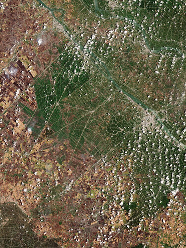 Image:
Earth from Space: The Mekong Delta
Image:
Earth from Space: The Mekong Delta
Revolutionize Your Workflows at SAT-LIVE DAY Dubai Roadshow 2024
19.4.2024 9:28 Satlab GeosolutionsDate & Venue: May 22-23, 2024 | Sharjah, UAE Ready to revolutionize your workflows? Join […]
The post Revolutionize Your Workflows at SAT-LIVE DAY Dubai Roadshow 2024 appeared first on Global Satellite Positioning Solutions | SatLab Geosolutions AB.
20240419-VŘ KP Havlíčkův Brod, KP Jihlava, KP Třebíč
19.4.2024 8:54 ČÚZK - předpisy a opatření Český úřad zeměměřický a katastrálnízveřejnil novou aktualitu: Oznámení o vyhlášení výběrového řízení na obsazení služebního místa ředitele/ředitelky Katastrálního pracoviště Havlíčkův Brod, Katastrálního pracoviště Jihlava a Katastrálního pracoviště Třebíč.
20240419-VŘ KP Havlíčkův Brod, KP Jihlava, KP Třebíč
19.4.2024 8:54 ČÚZK - aktuality v resortu Oznámení o vyhlášení výběrového řízení na obsazení služebního místa ředitele/ředitelky Katastrálního pracoviště Havlíčkův Brod, Katastrálního pracoviště Jihlava a Katastrálního pracoviště Třebíč.20240419-VŘ KP Havlíčkův Brod, KP Jihlava, KP Třebíč
19.4.2024 8:54 ČÚZK - aktuality v resortu Oznámení o vyhlášení výběrového řízení na obsazení služebního místa ředitele/ředitelky Katastrálního pracoviště Havlíčkův Brod, Katastrálního pracoviště Jihlava a Katastrálního pracoviště Třebíč.20240419-VŘ KP Havlíčkův Brod, KP Jihlava, KP Třebíč
19.4.2024 8:54 ČÚZK - předpisy a opatření Český úřad zeměměřický a katastrální zveřejnil novou aktualitu: Oznámení o vyhlášení výběrového řízení na obsazení služebního místa ředitele/ředitelky Katastrálního pracoviště Havlíčkův Brod, Katastrálního pracoviště Jihlava a Katastrálního pracoviště Třebíč.20240419-VŘ KP Havlíčkův Brod, KP Jihlava, KP Třebíč
19.4.2024 8:54 ČÚZK /Aktuality-resort/2024/20240419-VR-KP-Havlickuv-Brod,-KP-Jihlava,-KP-TrebMapa roku 2023
19.4.2024 8:42 Katedra geoinformatiky UP OlomoucNa ocenění MAPA ROKU 2023 v 26. ročníku odborné soutěže České kartografické společnosti byly nominovány čtyři produkty z naší katedry: V kategorii ATLASY, SOUBORY A EDICE MAP Atlas nářečí českého jazyka — nominativ singuláru feminin, výstup společného projektu dialektologů Ústavu pro jazyk český Akademie věd ČR a kartografů KGI V kategorii STUDENTSKÉ KARTOGRAFICKÉ […]
The post Mapa roku 2023 first appeared on Katedra geoinformatiky.
Data from mobile data operators in storymap
19.4.2024 8:28 Katedra geoinformatiky UP OlomoucOd minulého roku i my pracujeme s daty od mobilního operátora. Data nám umožňují mapovat a analyzovat pohyby a interakce lidí v novém kontextu. V naší nedávno zveřejněné story mapě (odkaz níže) můžete prozkoumat první výstupy z našich analýz. ️ Odkaz na story mapu: https://storymaps.arcgis.com/stories/a1c5a1328e4846679583484409895137
The post Data from mobile data operators in storymap first appeared on Katedra geoinformatiky.
Data from mobile data operators in storymap
19.4.2024 8:28 Katedra geoinformatiky UP OlomoucOd minulého roku i my pracujeme s daty od mobilního operátora. Data nám umožňují mapovat a analyzovat pohyby a interakce lidí v novém kontextu. V naší nedávno zveřejněné story mapě (odkaz níže) můžete prozkoumat první výstupy z našich analýz. ️ Odkaz na story mapu: https://storymaps.arcgis.com/stories/a1c5a1328e4846679583484409895137 — Since last year, we’ve been working with data from […]
The post Data from mobile data operators in storymap first appeared on Katedra geoinformatiky.
Where are they now?
18.4.2024 16:09 European GNSS Agency
Published:
17 April 2024
If you are a frequent flyer here at euspa.eu, you’ve probably read about CASSINI, the European Commission’s initiative geared to supporting entrepreneurs, start-ups and SMEs developing innovative applications and services that leverage the EU Space Programme.
Through its hackathons, matchmaking, challenges and business accelerator, CASSINI has provided financial support to almost 600 companies from all European Union countries.
But CASSINI’s impact doesn’t stop with the cash.
Leveraging the support they received via the CASSINI initiative, these companies have gone on to develop some very cool space-based solutions.
Take for example Arkadia Space, a Spanish orbital propulsion company. Since its involvement in the 2022 and 2023 editions of the Cassini Matchmaking, the company has designed, developed and brought to market a cost-effective propulsion system based on green propellants. Most recently, Arkadia Space closed on a EUR 2.8 million seed round of funding – an investment it plans to put towards boosting its R&D efforts and conducting an in-orbit demonstration of its technology.
Two other Matchmaking alumni, Orbital Matter and Dreamwaves, have also seen significant growth since their involvement with CASSINI. The former is developing an in-orbit 3D printing solution that will make manufacturing space infrastructure components faster and cheaper. The Polish start-up, which bills itself as a space-based construction company, finalised EUR 1 million in financing to demonstrate their solution in a microgravity environment and to invest in novel use cases for their technology.
Dreamwaves introduces cutting-edge technology for intuitive navigation using spatial audio. The approach enhances scalability and ease of deployment with a novel localization method. Leveraging spatial audio, the technology provides dynamic three-dimensional sound placement around the user, creating an immersive experience that adjusts to movements. The localization technique uses deep learning to correlate smartphone images with map data, improving AR experiences without extensive 3D mapping reliance.
"We are immensely proud that our project has been honoured with the Seal of Excellence of the European Innovation Council recognising the high quality of our innovative idea but also validates the diligent research we have conducted and our ambitious vision for the future. The ongoing support from the EUSPA, ever since our first challenge back in 2020, has been crucial in achieving this success, demonstrating the pivotal role that these collaborations have played in our journey," declared Hugo Furtado, Dreamwaves CEO.
From challenges to hackathons
On the CASSINI Challenges side of the equation there’s Artificial Brain, whose idea to optimise EO satellite scheduling using quantum computing took home the top prize in 2022 (when the contest was called the ‘myEUspace competition’). Last year the company, which now has offices in Europe, the US and India, earned a mention in the prestigious Nature India journal for its involvement with the precise placement of wind turbines.
Another winner, QuSide, was awarded for their idea on combining quantum machine learning with Galileo and Copernicus data as a means of optimising connectivity and computing. The Barcelona-based company’s flagship Quantum Random Number Generation (QRNG) product is already making waves in the market, with the innovative cloud service having launched on Amazon Web Services.
And let’s not forget our latest CASSINI Hackathon winners, which includes Hiris Guider. The Cyprus-based startup developed a platform service for evaluating emergency evacuation plans and scenarios using Copernicus data on land cover, vegetation, moisture and forests, along with data about population density.
After winning the top prize in 2023, the company received six months of business mentorship, including from EUSPA’s team of market experts. Most recently Hiris Guider successfully tested its algorithms on a case study involving wildfires in Rhodes.
You can’t win if you don’t play
This is but a small sampling of a long list of companies that have benefited from the CASSINI initiative – a list that continues to expand.
“Winning the CASSINI Challenges was transformative for our company, allowing us to refine our technology, expand our market reach, and open doors to new applications,” says Morten Fjord Pedersen, co-founder and CEO of ClearSky Vision, a start-up using deep learning algorithms to deliver cloud-free Sentinel-2 images. “10 out of 10, we would do it again.”
And so should you!
But, as they say, you can’t win if you don’t play. So don’t delay, go here to learn about the latest opportunities being offered by the CASSINI initiative.
Media note: This feature can be republished without charge provided the European Union Agency for the Space Programme (EUSPA) is acknowledged as the source at the top or the bottom of the story. You must request permission before you use any of the photographs on the site. If you republish, we would be grateful if you could link back to the EUSPA website (http://www.euspa.europa.eu).
Through its hackathons, matchmaking, challenges and business accelerator, CASSINI has invested a significant amount of money into a lot of EU Space-based companies.
Where are they now?
18.4.2024 16:09 European GNSS Agency Where are they now?Leveraging the support they received via the CASSINI initiative, companies of all shapes and sizes have gone on to develop some very cool space-based solutions.
Date
Image

Through its hackathons, matchmaking, challenges and business accelerator, CASSINI has invested a significant amount of money into a lot of EU Space-based companies.
Leveraging the support they received via the CASSINI initiative, companies of all shapes and sizes have gone on to develop some very cool space-based solutions.
If you are a frequent flyer here at euspa.eu, you’ve probably read about CASSINI, the European Commission’s initiative geared to supporting entrepreneurs, start-ups and SMEs developing innovative applications and services that leverage the EU Space Programme.
Through its hackathons, matchmaking, challenges and business accelerator, CASSINI has provided financial support to almost 600 companies from all European Union countries.
But CASSINI’s impact doesn’t stop with the cash.
Leveraging the support they received via the CASSINI initiative, these companies have gone on to develop some very cool space-based solutions.
Take for example Arkadia Space, a Spanish orbital propulsion company. Since its involvement in the 2022 and 2023 editions of the Cassini Matchmaking, the company has designed, developed and brought to market a cost-effective propulsion system based on green propellants. Most recently, Arkadia Space closed on a EUR 2.8 million seed round of funding – an investment it plans to put towards boosting its R&D efforts and conducting an in-orbit demonstration of its technology.
Two other Matchmaking alumni, Orbital Matter and Dreamwaves, have also seen significant growth since their involvement with CASSINI. The former is developing an in-orbit 3D printing solution that will make manufacturing space infrastructure components faster and cheaper. The Polish start-up, which bills itself as a space-based construction company, finalised EUR 1 million in financing to demonstrate their solution in a microgravity environment and to invest in novel use cases for their technology.
Dreamwaves introduces cutting-edge technology for intuitive navigation using spatial audio. The approach enhances scalability and ease of deployment with a novel localization method. Leveraging spatial audio, the technology provides dynamic three-dimensional sound placement around the user, creating an immersive experience that adjusts to movements. The localization technique uses deep learning to correlate smartphone images with map data, improving AR experiences without extensive 3D mapping reliance.
"We are immensely proud that our project has been honoured with the Seal of Excellence of the European Innovation Council recognising the high quality of our innovative idea but also validates the diligent research we have conducted and our ambitious vision for the future. The ongoing support from the EUSPA, ever since our first challenge back in 2020, has been crucial in achieving this success, demonstrating the pivotal role that these collaborations have played in our journey," declared Hugo Furtado, Dreamwaves CEO.
From challenges to hackathons
On the CASSINI Challenges side of the equation there’s Artificial Brain, whose idea to optimise EO satellite scheduling using quantum computing took home the top prize in 2022 (when the contest was called the ‘myEUspace competition’). Last year the company, which now has offices in Europe, the US and India, earned a mention in the prestigious Nature India journal for its involvement with the precise placement of wind turbines.
Another winner, QuSide, was awarded for their idea on combining quantum machine learning with Galileo and Copernicus data as a means of optimising connectivity and computing. The Barcelona-based company’s flagship Quantum Random Number Generation (QRNG) product is already making waves in the market, with the innovative cloud service having launched on Amazon Web Services.
And let’s not forget our latest CASSINI Hackathon winners, which includes Hiris Guider. The Cyprus-based startup developed a platform service for evaluating emergency evacuation plans and scenarios using Copernicus data on land cover, vegetation, moisture and forests, along with data about population density.
After winning the top prize in 2023, the company received six months of business mentorship, including from EUSPA’s team of market experts. Most recently Hiris Guider successfully tested its algorithms on a case study involving wildfires in Rhodes.
You can’t win if you don’t play
This is but a small sampling of a long list of companies that have benefited from the CASSINI initiative – a list that continues to expand.
“Winning the CASSINI Challenges was transformative for our company, allowing us to refine our technology, expand our market reach, and open doors to new applications,” says Morten Fjord Pedersen, co-founder and CEO of ClearSky Vision, a start-up using deep learning algorithms to deliver cloud-free Sentinel-2 images. “10 out of 10, we would do it again.”
And so should you!
But, as they say, you can’t win if you don’t play. So don’t delay, go here to learn about the latest opportunities being offered by the CASSINI initiative.
Media note: This feature can be republished without charge provided the European Union Agency for the Space Programme (EUSPA) is acknowledged as the source at the top or the bottom of the story. You must request permission before you use any of the photographs on the site. If you republish, we would be grateful if you could link back to the EUSPA website (http://www.euspa.europa.eu).
Industry sectors
Where are they now?
18.4.2024 16:09 European GNSS AgencyPublished:
18 April 2024
If you are a frequent flyer here at euspa.eu, you’ve probably read about CASSINI, the European Commission’s initiative geared to supporting entrepreneurs, start-ups and SMEs developing innovative applications and services that leverage the EU Space Programme.
Through its hackathons, matchmaking, challenges and business accelerator, CASSINI has provided financial support to almost 600 companies from all European Union countries.
But CASSINI’s impact doesn’t stop with the cash.
Leveraging the support they received via the CASSINI initiative, these companies have gone on to develop some very cool space-based solutions.
Take for example Arkadia Space, a Spanish orbital propulsion company. Since its involvement in the 2022 and 2023 editions of the Cassini Matchmaking, the company has designed, developed and brought to market a cost-effective propulsion system based on green propellants. Most recently, Arkadia Space closed on a EUR 2.8 million seed round of funding – an investment it plans to put towards boosting its R&D efforts and conducting an in-orbit demonstration of its technology.
Two other Matchmaking alumni, Orbital Matter and Dreamwaves, have also seen significant growth since their involvement with CASSINI. The former is developing an in-orbit 3D printing solution that will make manufacturing space infrastructure components faster and cheaper. The Polish start-up, which bills itself as a space-based construction company, finalised EUR 1 million in financing to demonstrate their solution in a microgravity environment and to invest in novel use cases for their technology.
Dreamwaves introduces cutting-edge technology for intuitive navigation using spatial audio. The approach enhances scalability and ease of deployment with a novel localization method. Leveraging spatial audio, the technology provides dynamic three-dimensional sound placement around the user, creating an immersive experience that adjusts to movements. The localization technique uses deep learning to correlate smartphone images with map data, improving AR experiences without extensive 3D mapping reliance.
"We are immensely proud that our project has been honoured with the Seal of Excellence of the European Innovation Council recognising the high quality of our innovative idea but also validates the diligent research we have conducted and our ambitious vision for the future. The ongoing support from the EUSPA, ever since our first challenge back in 2020, has been crucial in achieving this success, demonstrating the pivotal role that these collaborations have played in our journey," declared Hugo Furtado, Dreamwaves CEO.
From challenges to hackathons
On the CASSINI Challenges side of the equation there’s Artificial Brain, whose idea to optimise EO satellite scheduling using quantum computing took home the top prize in 2022 (when the contest was called the ‘myEUspace competition’). Last year the company, which now has offices in Europe, the US and India, earned a mention in the prestigious Nature India journal for its involvement with the precise placement of wind turbines.
Another winner, QuSide, was awarded for their idea on combining quantum machine learning with Galileo and Copernicus data as a means of optimising connectivity and computing. The Barcelona-based company’s flagship Quantum Random Number Generation (QRNG) product is already making waves in the market, with the innovative cloud service having launched on Amazon Web Services.
And let’s not forget our latest CASSINI Hackathon winners, which includes Hiris Guider. The Cyprus-based startup developed a platform service for evaluating emergency evacuation plans and scenarios using Copernicus data on land cover, vegetation, moisture and forests, along with data about population density.
After winning the top prize in 2023, the company received six months of business mentorship, including from EUSPA’s team of market experts. Most recently Hiris Guider successfully tested its algorithms on a case study involving wildfires in Rhodes.
You can’t win if you don’t play
This is but a small sampling of a long list of companies that have benefited from the CASSINI initiative – a list that continues to expand.
“Winning the CASSINI Challenges was transformative for our company, allowing us to refine our technology, expand our market reach, and open doors to new applications,” says Morten Fjord Pedersen, co-founder and CEO of ClearSky Vision, a start-up using deep learning algorithms to deliver cloud-free Sentinel-2 images. “10 out of 10, we would do it again.”
And so should you!
But, as they say, you can’t win if you don’t play. So don’t delay, go here to learn about the latest opportunities being offered by the CASSINI initiative.
Media note: This feature can be republished without charge provided the European Union Agency for the Space Programme (EUSPA) is acknowledged as the source at the top or the bottom of the story. You must request permission before you use any of the photographs on the site. If you republish, we would be grateful if you could link back to the EUSPA website (http://www.euspa.europa.eu).
Through its hackathons, matchmaking, challenges and business accelerator, CASSINI has invested a significant amount of money into a lot of EU Space-based companies.
Where are they now?
18.4.2024 16:09 European GNSS Agency Where are they now?Leveraging the support they received via the CASSINI initiative, companies of all shapes and sizes have gone on to develop some very cool space-based solutions.
riesgju
Date
Image
Through its hackathons, matchmaking, challenges and business accelerator, CASSINI has invested a significant amount of money into a lot of EU Space-based companies.
Leveraging the support they received via the CASSINI initiative, companies of all shapes and sizes have gone on to develop some very cool space-based solutions.
If you are a frequent flyer here at euspa.eu, you’ve probably read about CASSINI, the European Commission’s initiative geared to supporting entrepreneurs, start-ups and SMEs developing innovative applications and services that leverage the EU Space Programme.
Through its hackathons, matchmaking, challenges and business accelerator, CASSINI has provided financial support to almost 600 companies from all European Union countries.
But CASSINI’s impact doesn’t stop with the cash.
Leveraging the support they received via the CASSINI initiative, these companies have gone on to develop some very cool space-based solutions.
Take for example Arkadia Space, a Spanish orbital propulsion company. Since its involvement in the 2022 and 2023 editions of the Cassini Matchmaking, the company has designed, developed and brought to market a cost-effective propulsion system based on green propellants. Most recently, Arkadia Space closed on a EUR 2.8 million seed round of funding – an investment it plans to put towards boosting its R&D efforts and conducting an in-orbit demonstration of its technology.
Two other Matchmaking alumni, Orbital Matter and Dreamwaves, have also seen significant growth since their involvement with CASSINI. The former is developing an in-orbit 3D printing solution that will make manufacturing space infrastructure components faster and cheaper. The Polish start-up, which bills itself as a space-based construction company, finalised EUR 1 million in financing to demonstrate their solution in a microgravity environment and to invest in novel use cases for their technology.
Dreamwaves introduces cutting-edge technology for intuitive navigation using spatial audio. The approach enhances scalability and ease of deployment with a novel localization method. Leveraging spatial audio, the technology provides dynamic three-dimensional sound placement around the user, creating an immersive experience that adjusts to movements. The localization technique uses deep learning to correlate smartphone images with map data, improving AR experiences without extensive 3D mapping reliance.
"We are immensely proud that our project has been honoured with the Seal of Excellence of the European Innovation Council recognising the high quality of our innovative idea but also validates the diligent research we have conducted and our ambitious vision for the future. The ongoing support from the EUSPA, ever since our first challenge back in 2020, has been crucial in achieving this success, demonstrating the pivotal role that these collaborations have played in our journey," declared Hugo Furtado, Dreamwaves CEO.
From challenges to hackathons
On the CASSINI Challenges side of the equation there’s Artificial Brain, whose idea to optimise EO satellite scheduling using quantum computing took home the top prize in 2022 (when the contest was called the ‘myEUspace competition’). Last year the company, which now has offices in Europe, the US and India, earned a mention in the prestigious Nature India journal for its involvement with the precise placement of wind turbines.
Another winner, QuSide, was awarded for their idea on combining quantum machine learning with Galileo and Copernicus data as a means of optimising connectivity and computing. The Barcelona-based company’s flagship Quantum Random Number Generation (QRNG) product is already making waves in the market, with the innovative cloud service having launched on Amazon Web Services.
And let’s not forget our latest CASSINI Hackathon winners, which includes Hiris Guider. The Cyprus-based startup developed a platform service for evaluating emergency evacuation plans and scenarios using Copernicus data on land cover, vegetation, moisture and forests, along with data about population density.
After winning the top prize in 2023, the company received six months of business mentorship, including from EUSPA’s team of market experts. Most recently Hiris Guider successfully tested its algorithms on a case study involving wildfires in Rhodes.
You can’t win if you don’t play
This is but a small sampling of a long list of companies that have benefited from the CASSINI initiative – a list that continues to expand.
“Winning the CASSINI Challenges was transformative for our company, allowing us to refine our technology, expand our market reach, and open doors to new applications,” says Morten Fjord Pedersen, co-founder and CEO of ClearSky Vision, a start-up using deep learning algorithms to deliver cloud-free Sentinel-2 images. “10 out of 10, we would do it again.”
And so should you!
But, as they say, you can’t win if you don’t play. So don’t delay, go here to learn about the latest opportunities being offered by the CASSINI initiative.
Media note: This feature can be republished without charge provided the European Union Agency for the Space Programme (EUSPA) is acknowledged as the source at the top or the bottom of the story. You must request permission before you use any of the photographs on the site. If you republish, we would be grateful if you could link back to the EUSPA website (http://www.euspa.europa.eu).
Industry sectors
Where are they now?
18.4.2024 16:09 European GNSS AgencyPublished:
18 April 2024
If you are a frequent flyer here at euspa.eu, you’ve probably read about CASSINI, the European Commission’s initiative geared to supporting entrepreneurs, start-ups and SMEs developing innovative applications and services that leverage the EU Space Programme.
Through its hackathons, matchmaking, challenges and business accelerator, CASSINI has provided financial support to almost 600 companies from all European Union countries.
But CASSINI’s impact doesn’t stop with the cash.
Leveraging the support they received via the CASSINI initiative, these companies have gone on to develop some very cool space-based solutions.
Take for example Arkadia Space, a Spanish orbital propulsion company. Since its involvement in the 2022 and 2023 editions of the Cassini Matchmaking, the company has designed, developed and brought to market a cost-effective propulsion system based on green propellants. Most recently, Arkadia Space closed on a EUR 2.8 million seed round of funding – an investment it plans to put towards boosting its R&D efforts and conducting an in-orbit demonstration of its technology.
Two other Matchmaking alumni, Orbital Matter and Dreamwaves, have also seen significant growth since their involvement with CASSINI. The former is developing an in-orbit 3D printing solution that will make manufacturing space infrastructure components faster and cheaper. The Polish start-up, which bills itself as a space-based construction company, finalised EUR 1 million in financing to demonstrate their solution in a microgravity environment and to invest in novel use cases for their technology.
Dreamwaves introduces cutting-edge technology for intuitive navigation using spatial audio. The approach enhances scalability and ease of deployment with a novel localization method. Leveraging spatial audio, the technology provides dynamic three-dimensional sound placement around the user, creating an immersive experience that adjusts to movements. The localization technique uses deep learning to correlate smartphone images with map data, improving AR experiences without extensive 3D mapping reliance.
"We are immensely proud that our project has been honoured with the Seal of Excellence of the European Innovation Council recognising the high quality of our innovative idea but also validates the diligent research we have conducted and our ambitious vision for the future. The ongoing support from the EUSPA, ever since our first challenge back in 2020, has been crucial in achieving this success, demonstrating the pivotal role that these collaborations have played in our journey," declared Hugo Furtado, Dreamwaves CEO.
From challenges to hackathons
On the CASSINI Challenges side of the equation there’s Artificial Brain, whose idea to optimise EO satellite scheduling using quantum computing took home the top prize in 2022 (when the contest was called the ‘myEUspace competition’). Last year the company, which now has offices in Europe, the US and India, earned a mention in the prestigious Nature India journal for its involvement with the precise placement of wind turbines.
Another winner, QuSide, was awarded for their idea on combining quantum machine learning with Galileo and Copernicus data as a means of optimising connectivity and computing. The Barcelona-based company’s flagship Quantum Random Number Generation (QRNG) product is already making waves in the market, with the innovative cloud service having launched on Amazon Web Services.
And let’s not forget our latest CASSINI Hackathon winners, which includes Hiris Guider. The Cyprus-based startup developed a platform service for evaluating emergency evacuation plans and scenarios using Copernicus data on land cover, vegetation, moisture and forests, along with data about population density.
After winning the top prize in 2023, the company received six months of business mentorship, including from EUSPA’s team of market experts. Most recently Hiris Guider successfully tested its algorithms on a case study involving wildfires in Rhodes.
You can’t win if you don’t play
This is but a small sampling of a long list of companies that have benefited from the CASSINI initiative – a list that continues to expand.
“Winning the CASSINI Challenges was transformative for our company, allowing us to refine our technology, expand our market reach, and open doors to new applications,” says Morten Fjord Pedersen, co-founder and CEO of ClearSky Vision, a start-up using deep learning algorithms to deliver cloud-free Sentinel-2 images. “10 out of 10, we would do it again.”
And so should you!
But, as they say, you can’t win if you don’t play. So don’t delay, go here to learn about the latest opportunities being offered by the CASSINI initiative.
Media note: This feature can be republished without charge provided the European Union Agency for the Space Programme (EUSPA) is acknowledged as the source at the top or the bottom of the story. You must request permission before you use any of the photographs on the site. If you republish, we would be grateful if you could link back to the EUSPA website (http://www.euspa.europa.eu).
Through its hackathons, matchmaking, challenges and business accelerator, CASSINI has invested a significant amount of money into a lot of space-based companies.
Dubai floods seen from space
18.4.2024 14:45 ESA Observing the Earth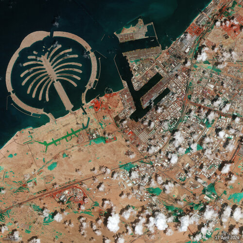 Image:
Dubai floods seen from space
Image:
Dubai floods seen from space
Earth Observation Excellence Award 2024 winner
18.4.2024 14:04 ESA Observing the Earth
Celebrating the outstanding efforts of scientists and researchers who have advanced the innovative application of Earth observation data, ESA proudly announces the recipient of this year's esteemed Excellence Award. Dr Iestyn Woolway, from Bangor University in the UK, wins the 2024 Earth Observation Excellence Award.
Spolupořádali jsme opět český stánek na Amsterdam Drone Week 2024
18.4.2024 11:05 UAVA Tento týden se konal opět český stánek na #Amsterdam #Drone #Week 2024, který pořádala Aliance s Ambasádou ČR v Haagu v rámci PROPED. Na stánku nás navštívil i velvyslanec ČR v Nizozemsku, zástupce CzechTrade a spousta evropských stakeholderů, kteří neustále oceňují naši aktivitu ČR v dronech.Výběrové řízení na KP Třebíč
18.4.2024 10:53 ČÚZK - předpisy a opatření Katastrální úřad pro Vysočinu - Katastrální pracoviště Třebíč zveřejnil novou aktualitu: Oznámení o vyhlášení výběrového řízení na služební místo rada/odborný rada – ředitel/ka Katastrálního pracoviště Třebíč na Katastrálním úřadu pro Vysočinu, místo výkonu služby Třebíč.výběrové řízení na KP Havlíčkův Brod
18.4.2024 10:52 ČÚZK /Urady/Katastralni-urady/Katastralni-urady/Katastralni-urad-pro-Vysocinu/O-uradu/Aktuality/vyberove-rizeni-na-KP-Havlickuv-Brod-(1)Výběrové řízení na KP Havlíčkův Brod
18.4.2024 10:52 ČÚZK - předpisy a opatření Katastrální úřad pro Vysočinu - Katastrální pracoviště Havlíčkův Brod zveřejnil novou aktualitu: Oznámení o vyhlášení výběrového řízení na služební místo rada/odborný rada – ředitel/ka Katastrálního pracoviště Havlíčkův Brod na Katastrálním úřadu pro Vysočinu, místo výkonu služby Havlíčkův Brod.Výběrové řízení na KP Jihlava
18.4.2024 10:50 ČÚZK /Urady/Katastralni-urady/Katastralni-urady/Katastralni-urad-pro-Vysocinu/O-uradu/Aktuality/Vyberove-rizeni-na-KP-Jihlava-(1)Výběrové řízení na KP Jihlava
18.4.2024 10:50 ČÚZK - předpisy a opatření Katastrální úřad pro Vysočinu - Katastrální pracoviště Jihlava zveřejnil novou aktualitu: Oznámení o vyhlášení výběrového řízení na služební místo rada/odborný rada – ředitel/ka Katastrálního pracoviště Jihlava na Katastrálním úřadu pro Vysočinu, místo výkonu služby Jihlava.Provision of support services to the European Union Agency for the Space Programme and the European Commission
18.4.2024 10:22 European GNSS Agency Provision of support services to the European Union Agency for the Space Programme and the European Commission ilariaLink to the procurement documents included in the Contract Notice.
An informative webinar took place on 15 March at 09:30 CET
Updated Deadline for submission of offers: 16.05.2024.
Documents
Language
Language
Language
Language
Language
Submission deadline
Ref. no.
EUSPA/OP/37/23 (EUSPA/PRG/2024/OP/0001)
Status of the opportunity
Provision of support services to the European Union Agency for the Space Programme and the European Commission
18.4.2024 10:22 European GNSS Agency Provision of support services to the European Union Agency for the Space Programme and the European Commission ilariaLink to the procurement documents included in the Contract Notice.
An informative webinar took place on 15 March at 09:30 CET
Updated Deadline for submission of offers: 16.05.2024.
Documents
Language
Language
Language
Language
Language
Submission deadline
Ref. no.
EUSPA/OP/37/23 (EUSPA/PRG/2024/OP/0001)
Status of the opportunity
rada-odborný rada -ředitel-ředitelka Katastrálního pracoviště Třebíč
18.4.2024 9:40 ČÚZK - předpisy a opatření Katastrální úřad pro Vysočinu Katastrální pracoviště Třebíčvypisuje výběrové řízení na místo
rada-odborný rada -ředitel-ředitelka Katastrálního pracoviště Třebíč
rada-odborný rada -ředitel-ředitelka Katastrálního pracoviště Třebíč
18.4.2024 9:40 ČÚZK /Urady/Katastralni-urady/Katastralni-urady/Katastralni-urad-pro-Vysocinu/Uredni-deska/Oznameni-a-jina-uredni-sdeleni/Volna-mista/DMS/rada-odborny-rada-reditel-reditelka-Katastraln-(2)rada-odborný rada -ředitel-ředitelka Katastrálního pracoviště Třebíč
18.4.2024 9:40 ČÚZK - volná místa Katastrální úřad pro Vysočinu Katastrální pracoviště Třebíč vypisuje výběrové řízení na místo rada-odborný rada -ředitel-ředitelka Katastrálního pracoviště Třebíčrada-odborný rada -ředitel-ředitelka Katastrálního pracoviště Jihlava
18.4.2024 9:36 ČÚZK /Urady/Katastralni-urady/Katastralni-urady/Katastralni-urad-pro-Vysocinu/Uredni-deska/Oznameni-a-jina-uredni-sdeleni/Volna-mista/DMS/rada-odborny-rada-reditel-reditelka-Katastraln-(1)rada-odborný rada -ředitel-ředitelka Katastrálního pracoviště Jihlava
18.4.2024 9:36 ČÚZK - volná místa Katastrální úřad pro Vysočinu Katastrální pracoviště Jihlava vypisuje výběrové řízení na místo rada-odborný rada -ředitel-ředitelka Katastrálního pracoviště Jihlavarada-odborný rada -ředitel-ředitelka Katastrálního pracoviště Jihlava
18.4.2024 9:36 ČÚZK - předpisy a opatření Katastrální úřad pro Vysočinu Katastrální pracoviště Jihlavavypisuje výběrové řízení na místo
rada-odborný rada -ředitel-ředitelka Katastrálního pracoviště Jihlava
rada-odborný rada - ředitel-ředitelka Katastrálního pracoviště Havlíčkův Brod
18.4.2024 9:22 ČÚZK - předpisy a opatření Katastrální úřad pro Vysočinu Katastrální pracoviště Havlíčkův Brodvypisuje výběrové řízení na místo
rada-odborný rada - ředitel-ředitelka Katastrálního pracoviště Havlíčkův Brod
© geoinformace.cz CMS Toolkit