


![]()

zprávy
zdroje zpráv:Future-proofing ice measurements from space
19.1.2023 15:06 ESA Observing the Earth
With diminishing ice one of the biggest casualties of our warming world, it’s imperative that accurate measurements continue to be made for scientific research and climate policy, as well as for practical applications such as ship routing.
To ensure that ESA and NASA are getting the best out of their ice-measuring satellites and to help prepare for Europe’s new CRISTAL satellite, the two space agencies along with the British Antarctic Survey and a team of scientists teamed up recently to carry out an ambitious campaign in Antarctica.
Vedoucí skupiny GIS a hlavní specialista GIS (Praha) - Atelier T-plan, s.r.o.
19.1.2023 10:42 Blogující geomatici - FAV ZČUNáplň práce:
- Plánování a koordinace provozních činností skupiny GIS, přidělování práce členům skupiny a optimalizace jejich pracovního vytížení. Přitom je přímo podřízen jednateli společnosti.
- Spolupráce s externím správcem sítě jako prostředník při řešení aktuálních a plánovaných provozních událostí souvisejících s HW a SW vybavením společnosti.
- Správa softwaru a licencí a spolupráce s dodavateli softwaru (Maintenance softwaru ArcMap).
- Poskytování technické podpory projektantům při tvorbě územně plánovací dokumentace (ZÚR, územní plán, územní studie, …).
Hlavní náplní práce je:
- Správa prostorových dat ve struktuře standardních datových modelů územního plánování v prostředí GIS
- Analýza dat založená na základních funkcích geoprocessingu
- Tvorba mapových výstupů a tisk velkoformátových výkresů
- Tvorba vlastních analytických a automatizovaných nástrojů v prostředí ArcGis (Python, ModelBuilder)
EUSPA extends cooperation with CNES for delivery of the Galileo Search and Rescue Service
19.1.2023 10:24 European GNSS Agency
Launched on 15 December 2016, the Galileo Search and Rescue (SAR) service provides aid to people in distress or imminent danger. The Galileo SAR Service relays highly accurate, timely and reliable distress alert data to Cospas-Sarsat.
Under EUSPA management, the Galileo SAR Service has undergone continuous improvements developing breakthrough features such as the Galileo Return Link Service which was declared operational in January 2020. In February 2022, the Galileo SAR reached new heights with a record-breaking location accuracy performance of 98.12% below 2km. The EU constellation is the biggest contributor to the Cospas-Sarsat MEOSAR system, with experts estimating that Galileo helps to save about 2000 lives annually.
Read this: La Réunion EU MEOLUT, a corner stone new infrastructure for SAR Galileo delivery in the Indian Ocean
Why CNES?
Prior to the launch of the Galileo Initial Services, to ensure that end-users make the most of the Service, the European Commission established the SAR/Galileo Data Service Provider (SGDSP) a new Entity entrusted to CNES tasked to provide the Galileo SAR Service in a safe, reliable and secure manner
Given its longstanding history with COSPAS-SARSAT and its expertise in managing space ground infrastructures, in 2015 CNES was assigned to operate the SAR Service from SAR/Galileo Service Centre (SGSC), a Galileo Service Facility hosted in the Toulouse Space Center (CNES premises). The SGSC Facility monitors the overall SAR/Galileo Ground Segment (SGS), coordinates the maintenance activities and computes in near-real-time Service key performance indicators.
"CNES has been present from the foundation of the SAR/Galileo system up to the current exploitation phase building up a unique technical expertise, thus we are proud to be able to continue our work to support the search and Rescue operations", says Philippe Baptiste, President of CNES .

EUSPA entrusts CNES once again with the responsibility of providing the SAR-Galileo services.
This new Contract will further expand the long-lasting and excellent collaboration between EUSPA and CNES in the SAR activities. It will ensure the continuation of the operations, maintenance and hosting services of the SAR/Galileo and the uninterrupted delivery of SAR signals and SAR data needed to guarantee the SAR/Galileo Service contribution to Cospas-Sarsat to the upmost standards.
Watch this: Search and Rescue in the Arctic supported by EUSpace
"We are happy to announce the extension of our collaboration in such an important service that delivers tangible benefits to EU and global citizens. I am also very pleased to see Member States actively participating in the development, support and evolution of the EU Space Programme" —EUSPA Executive Director, Rodrigo da Costa.
The duration of the Framework Contract is 10 years, which is warranted due to the international structure of the Cospas-Sarsat programme and the EUSPA objective to establish a long-term cooperation for the implementation of the current and future SAR/Galileo Services.
The operations, maintenance and hosting services to be provided will remain a unique and non-competitive market and CNES will be the only entity capable of providing the above service in support of Cospas-Sarsat.
A team of qualified CNES personnel comprised of Navigation, System, Operations and SAR experts will support EUSPA to deliver the Galileo SAR service by seamlessly operating the ground segment, maintaining the infrastructure and offering technical support, among other objectives as well. Detailed information can be found in the Galileo SAR Service Definition Document.
What’s next for Galileo SAR?
The Galileo Full Operational Capability Programme roadmap foresees evolutions in the Galileo Services and Galileo System in the field of Emergency response. Both evolutions have strict links to the SGDSP activities foreseen under the new Framework Contract as their implementation directly affect the hosting, maintenance, operations and/or the Service monitoring tasks.
Media note: This feature can be republished without charge provided the European Union Agency for the Space Programme (EUSPA) is acknowledged as the source at the top or the bottom of the story. You must request permission before you use any of the photographs on the site. If you republish, we would be grateful if you could link back to the EUSPA website (http://www.euspa.europa.eu).
STOP-STAV v k.ú. Horní Branná
19.1.2023 10:17 ČÚZK /Urady/Katastralni-urady/Katastralni-urady/Katastralni-urad-pro-Liberecky-kraj/Katastralni-pracoviste/KP-Semily/O-uradu/Aktuality/STOP-STAV-v-k-u-Horni-BrannaSTOP-STAV v k.ú. Horní Branná
19.1.2023 10:17 ČÚZK - předpisy a opatření Katastrální úřad pro Liberecký kraj - Katastrální pracoviště Semily zveřejnil novou aktualitu: V katastrálním území Horní Branná byl vyhlášen ke dni 19.1.2023 STOP-STAV pro všechny zápisy do katastru (vklady a záznamy)do doby zplatnění obnoveného katastrálního operátu mapováním. Listiny budou pouze přijaty a zaplombovány.Geodetickou veřejnost tímto žádáme, aby danému STOP-STAVU přizpůsobili plánované, nebo rozpracované zakázky v tomto katastrálním území.
TurboCAD Platinum v akční ceně!
18.1.2023 19:39 ŠPINAR - software TurboCAD Platinum 28 CZ v akční ceně do 29. 1. 2023.Nová verze TurboCAD Platinum!
18.1.2023 19:39 ŠPINAR - softwareNová verze TurboCAD Platinum 28 CZ již v naší nabídce. V akční ceně do 23. 10. 2022,
The post Nová verze TurboCAD Platinum! appeared first on ŠPINAR – software.
TurboCAD Platinum v akční ceně!
18.1.2023 19:39 ŠPINAR - softwareTurboCAD Platinum 28 CZ v akční ceně do 29. 1. 2023.
The post TurboCAD Platinum v akční ceně! appeared first on ŠPINAR – software.
Aktualizace dat v mapových aplikacích
18.1.2023 16:54 Jihočeský krajData katastru nemovitostí (DKM, KMD, KM-D) byla v mapových aplikacích a výdejním modulu aktualizována k 1.1.2023.
Informace o výsledcích kontrol dle § 26 zákona č. 255/2012 Sb. za rok 2022
18.1.2023 15:22 ČÚZK - předpisy a opatření Zeměměřický a katastrální inspektorát v Pardubicíchvydává informace o výsledcích kontrol dle § 26 zákona č. 255/2012 Sb. za rok 2022
2022
Výroční zpráva dle zákona č. 106/1999 Sb. za rok 2022
18.1.2023 13:59 ČÚZK /Urady/Katastralni-urady/Katastralni-urady/Katastralni-urad-pro-Jihocesky-kraj/Vyrocni-zpravy/Vyrocni-zprava-dle-zakona-c-106-1999-Sb-za-rok-202Výroční zpráva dle zákona č. 106/1999 Sb. za rok 2022
18.1.2023 13:59 ČÚZK - předpisy a opatření Katastrální úřad pro Jihočeský krajvydává výroční zprávu úřadu za rok
2022
Výroba nábytku – snížení časové náročnosti a pracnosti – partner SK
17.1.2023 17:40 ŠPINAR - softwareReference s ohledem na využívání programů DAEX DESIGN u firmy DL Interier, s.r.o.
The post Výroba nábytku – snížení časové náročnosti a pracnosti – partner SK appeared first on ŠPINAR – software.
Výroba nábytku – snížení časové náročnosti a pracnosti – partner SK
17.1.2023 17:40 ŠPINAR - softwareReference s ohledem na využívání programů DAEX DESIGN Pro u firma DL Interier, s.r.o.
The post Výroba nábytku – snížení časové náročnosti a pracnosti – partner SK appeared first on ŠPINAR – software.
Výroba nábytku – snížení časové náročnosti a pracnosti – partner SK
17.1.2023 17:40 ŠPINAR - software Reference s ohledem na využívání programů DAEX DESIGN u firmy DL Interier, s.r.o.Výroba nábytku a snížení časové náročnosti a pracnosti – slovenský partner
17.1.2023 17:40 ŠPINAR - softwareReference s ohledem na využívání programů DAEX DESIGN Pro u firma DL Interier, s.r.o.
The post Výroba nábytku a snížení časové náročnosti a pracnosti – slovenský partner appeared first on ŠPINAR – software.
Zprovoznění RSS kanálu
17.1.2023 15:33 ČÚZK - předpisy a opatření Český úřad zeměměřický a katastrálnízveřejnil novou aktualitu: Oznamujeme Vám, že byl zprovozněn RSS kanál 2.0 pro Stanoviska k aplikaci vyhlášky č. 357/2013 Sb., který je umístěn v dolní části stránky v sekci Předpisy/Stanoviska k aplikaci katastrální vyhlášky/Stanoviska k aplikaci vyhlášky č. 357/2013 Sb., a to včetně návodu, jak číst RSS kanály. Uživatelé budou pomocí tohoto kanálu informováni o nově zveřejněných stanoviskách ČÚZK.
Zprovoznění RSS kanálu
17.1.2023 15:33 ČÚZK /Zememerictvi/Zememericke-cinnosti/Aktuality-pro-zememerice/2023/Zprovozneni-RSS-kanaluZprovoznění RSS kanálu
17.1.2023 15:33 ČÚZK - RSS kanál pro zeměměřiče Oznamujeme Vám, že byl zprovozněn RSS kanál 2.0 pro Stanoviska k aplikaci vyhlášky č. 357/2013 Sb., který je umístěn v dolní části stránky v sekci Předpisy/Stanoviska k aplikaci katastrální vyhlášky/Stanoviska k aplikaci vyhlášky č. 357/2013 Sb., a to včetně návodu, jak číst RSS kanály. Uživatelé budou pomocí tohoto kanálu informováni o nově zveřejněných stanoviskách ČÚZK.2023 Copernicus Sentinels calendar
17.1.2023 14:20 ESA Observing the Earth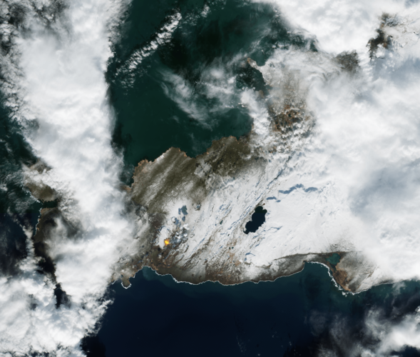
Download the 2023 Sentinels calendar
rada / odborný rada – metodik katastru nemovitostí v oddělení metodiky a kontroly v Kanceláři ředite
17.1.2023 14:18 ČÚZK - předpisy a opatření Katastrální úřad pro Liberecký krajvypisuje výběrové řízení na místo
rada / odborný rada – metodik katastru nemovitostí v oddělení metodiky a kontroly v Kanceláři ředitele Katastrálního úřadu pro Liberecký kraj
rada / odborný rada – metodik katastru nemovitostí v oddělení metodiky a kontroly v Kanceláři ředite
17.1.2023 14:18 ČÚZK /Urady/Katastralni-urady/Katastralni-urady/Katastralni-urad-pro-Liberecky-kraj/Uredni-deska/Oznameni-a-jina-uredni-sdeleni/Volna-mista/DMS/rada-odborny-rada-–-metodik-katastru-nemovitosti-vrada / odborný rada – metodik katastru nemovitostí v oddělení metodiky a kontroly v Kanceláři ředite
17.1.2023 14:18 ČÚZK - volná místa Katastrální úřad pro Liberecký kraj vypisuje výběrové řízení na místo rada / odborný rada – metodik katastru nemovitostí v oddělení metodiky a kontroly v Kanceláři řediteZmďż˝na cen software a sluďż˝eb spoleďż˝nosti GISOFT (17.1.2023)
17.1.2023 13:41 GISoftV souvislosti se v�eobecnou situac� jsme nuceni p�istoupit k �prav� cen na�ich software.
Nov� ceny naleznete v na�em cen�ku.
odborný/vrchní referent - obnova katastrálního operátu v oddělení aktualizace KN Katastrálního praco
17.1.2023 13:32 ČÚZK - volná místa Katastrální úřad pro Jihočeský kraj Katastrální pracoviště Tábor vypisuje výběrové řízení na místo odborný/vrchní referent - obnova katastrálního operátu v oddělení aktualizace KN Katastrálního pracoodborný/vrchní referent - obnova katastrálního operátu v oddělení aktualizace KN Katastrálního praco
17.1.2023 13:32 ČÚZK /Urady/Katastralni-urady/Katastralni-urady/Katastralni-urad-pro-Jihocesky-kraj/Uredni-deska/Oznameni-a-jina-uredni-sdeleni/Volna-mista/DMS/odborny-vrchni-referent-obnova-katastralniho-operaodborný/vrchní referent - obnova katastrálního operátu v oddělení aktualizace KN Katastrálního praco
17.1.2023 13:32 ČÚZK - předpisy a opatření Katastrální úřad pro Jihočeský kraj Katastrální pracoviště Táborvypisuje výběrové řízení na místo
odborný/vrchní referent - obnova katastrálního operátu v oddělení aktualizace KN Katastrálního pracoviště Tábor (ID SM 30000337/30003961)
Krátka správa č. 1/2023
17.1.2023 12:49 Komora geodetů a kartografů SRThe post Krátka správa č. 1/2023 appeared first on Komora geodetov a kartografov.
rada / odborný rada – obnova katastrálního operátu v oddělení aktualizace katastru nemovitostí na K
17.1.2023 12:27 ČÚZK - volná místa Katastrální úřad pro Liberecký kraj - Katastrální pracoviště Liberec vypisuje výběrové řízení na místo rada / odborný rada – obnova katastrálního operátu v oddělení aktualizace katastru nemovitostí na Krada / odborný rada – obnova katastrálního operátu v oddělení aktualizace katastru nemovitostí na K
17.1.2023 12:27 ČÚZK - předpisy a opatření Katastrální úřad pro Liberecký kraj - Katastrální pracoviště Liberecvypisuje výběrové řízení na místo
rada / odborný rada – obnova katastrálního operátu v oddělení aktualizace katastru nemovitostí na Katastrálním pracovišti Liberec Katastrálního úřadu pro Liberecký kraj
rada / odborný rada – obnova katastrálního operátu v oddělení aktualizace katastru nemovitostí na K
17.1.2023 12:27 ČÚZK /Urady/Katastralni-urady/Katastralni-urady/Katastralni-urad-pro-Liberecky-kraj/Uredni-deska/Oznameni-a-jina-uredni-sdeleni/Volna-mista/DMS/rada-odborny-rada-–-obnova-katastralniho-opera-(1)VIDEOZÁZNAM SE SEMINÁŘE „GEOPORTÁL 2.0 – AKTUALIZACE UŽIVATELSKÝCH POŽADAVKŮ“
17.1.2023 11:23 CENIA - národní geoportál INSPIRE Česká informační agentura životního prostředí zahájila nový rok seminářem k aktualizaci uživatelských požadavků ke geoportálu. Tento seminář se uskutečnil dne 4. 1. 2023 a jeho účastníci se kromě prezenční účasti mohli připojit i online. Videozáznam ze semináře je dostupný pod tímto odkazem. Výstup z mentimeteru zde. Seminář navazoval na akci, která se konala již v prosinci roku 2019. Tehdy...Jak si vytvořit vektorové podkladové mapy na míru?
17.1.2023 11:01 blog ARCDATA Ať už jste vývojář, designér nebo profesionál v oboru GIS, jistě pracujete s podkladovými mapami a určitě vás již napadlo, že byste si výchozí podkladové mapy potřebovali pro svůj projekt či aplikaci upravit. V tomto článku vám představíme nástroj, který umožňuje vytvářet vlastní styly vektorových podkladových map přesně podle vašich představ.Výstava: Mapa Království českého, 1720 [Knihovna geografie, byTopic]
17.1.2023 0:00 Katedra aplikované geoinformatiky a kartografie Přf UK Srdečně vás zveme na výstavu Mapa Království českého, 1720, která vznikla ve spolupráci geografické sekce PřF UK, Mapové sbírky a Knihovny geografie. Výstava představuje život a dílo rakouského vojenského inženýra a kartografa Johanna Christopha Müllera (1673–1721), jehož tzv. velká mapa Čech pod titulem Mappa geographica Regni Bohemiae byla publikována před 300 lety. Výstava vznikla již v roce 2020, ale v souvislosti s koronavirovými opatřeními nebyla dostupná, proto ji znovu zpřístupňujeme veřejnosti.Oznámení o vyhlášení výběrového řízení
16.1.2023 13:59 ČÚZK - předpisy a opatření Zeměměřický a katastrální inspektorát v Liberci zveřejnil novou aktualitu: Oznámení o vyhlášení výběrového řízení na služební místo inspektor Zeměměřického a katastrálního inspektorátu v LiberciOznámení o vyhlášení výběrového řízení
16.1.2023 13:59 ČÚZK - předpisy a opatření Zeměměřický a katastrální inspektorát v Liberci zveřejnil novou aktualitu: Oznámení o vyhlášení výběrového řízení na služební místo inspektorZeměměřického a katastrálního inspektorátu v Liberci
Rada / odborný rada - inspektor ZKI v Liberci
16.1.2023 13:18 ČÚZK - volná místa Zeměměřický a katastrální inspektorát v Liberci vypisuje výběrové řízení na místo Rada / odborný rada - inspektor ZKI v LiberciRada / odborný rada - inspektor ZKI v Liberci
16.1.2023 13:18 ČÚZK /Urady/Zememericke-a-katastralni-inspektoraty/Zememericke-a-katastralni-inspektoraty/Zememericky-a-katastralni-inspektorat-v-Liberci/Uredni-deska/Oznameni-a-jina-uredni-sdeleni/Volna-mista/DMS/Rada-odborny-rada-inspektor-ZKI-v-LiberciRada / odborný rada - inspektor ZKI v Liberci
16.1.2023 13:18 ČÚZK - předpisy a opatření Zeměměřický a katastrální inspektorát v Libercivypisuje výběrové řízení na místo
Rada / odborný rada - inspektor ZKI v Liberci
Nový přírůstek Trimble R780
16.1.2023 12:55 GeotronicsVelmi přesný GNSS systém navržený pro práci v nejnáročnějších podmínkách.
The post Nový přírůstek Trimble R780 first appeared on GEOTRONICS Praha.
Rozpočet úřadu za rok 2023
16.1.2023 12:02 ČÚZK /Urady/Zememericke-a-katastralni-inspektoraty/Zememericke-a-katastralni-inspektoraty/Zememericky-a-katastralni-inspektorat-v-Praze/Rozpocet/Rozpocet-uradu-za-rok-2023Rozpočet úřadu za rok 2023
16.1.2023 12:02 ČÚZK - předpisy a opatření Zeměměřický a katastrální inspektorát v Prazevystavuje rozpočet úřadu za rok 2023
2023
Looking back at the eruption that shook the world
16.1.2023 11:05 ESA Observing the Earth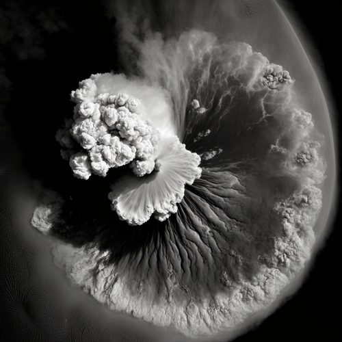
One year ago, the Hunga Tonga-Hunga Ha’apai volcano erupted, causing widespread destruction to the Pacific Island Nation of Tonga, spewing volcanic material up to 58 km into the atmosphere. It brought a nearly 15 m tsunami that crashed ashore, destroying villages, and creating a sonic boom that rippled around the world – twice.
Satellites orbiting Earth scrambled to capture images and data of the aftermath of the disaster. Almost a year later, you can now listen to a sonification of the largest eruption of the 21st Century, created using wind data from ESA’s Aeolus mission.
Výroční zpráva dle zákona č. 106/1999 Sb. za rok 2022
16.1.2023 10:40 ČÚZK - předpisy a opatření Katastrální úřad pro Pardubický krajvydává výroční zprávu úřadu za rok 2022
2022
Výroční zpráva dle zákona č. 106/1999 Sb. za rok 2022
16.1.2023 10:40 ČÚZK /Urady/Katastralni-urady/Katastralni-urady/Katastralni-urad-pro-Pardubicky-kraj/Vyrocni-zpravy/Vyrocni-zprava-dle-zakona-c-106-1999-Sb-za-rok-202
Nové číslo GaKO
16.1.2023 10:37
ÚGKK SR
Nové číslo časopisu Geodetického a Kartografického Obzoru 01/2023
20230316-GaKO
16.1.2023 10:11 ČÚZK - aktuality v resortu Aktuální číslo Geodetického a kartografického obzoru (3/2023) je k dispozici ke stažení.20230414-GaKO
16.1.2023 10:11 ČÚZK - předpisy a opatření Český úřad zeměměřický a katastrální zveřejnil novou aktualitu: Aktuální číslo Geodetického a kartografického obzoru (4/2023) je k dispozici ke stažení.20230217-GaKO
16.1.2023 10:11 ČÚZK - předpisy a opatření Český úřad zeměměřický a katastrální zveřejnil novou aktualitu: Aktuální číslo Geodetického a kartografického obzoru (2/2023) je k dispozici ke stažení.20230316-GaKO
16.1.2023 10:11 ČÚZK - předpisy a opatření Český úřad zeměměřický a katastrální zveřejnil novou aktualitu: Aktuální číslo Geodetického a kartografického obzoru (3/2023) je k dispozici ke stažení.20230116-GaKO
16.1.2023 10:11 ČÚZK - předpisy a opatření Český úřad zeměměřický a katastrální zveřejnil novou aktualitu: Aktuální číslo Geodetického a kartografického obzoru (1/2023) je k dispozici ke stažení.20230217-GaKO
16.1.2023 10:11 ČÚZK - aktuality v resortu Aktuální číslo Geodetického a kartografického obzoru (2/2023) je k dispozici ke stažení.20230414-GaKO
16.1.2023 10:11 ČÚZK - aktuality v resortu Aktuální číslo Geodetického a kartografického obzoru (4/2023) je k dispozici ke stažení.20230116-GaKO
16.1.2023 10:11 ČÚZK - aktuality v resortu Aktuální číslo Geodetického a kartografického obzoru (1/2023) je k dispozici ke stažení.20230116-GaKO
16.1.2023 10:11 ČÚZK - aktuality v resortu Aktuální číslo Geodetického a kartografického obzoru (1/2023) je k dispozici ke stažení.Showcasing the benefits and successes of Fundamental Elements
16.1.2023 9:39 European GNSS Agency
The space downstream market is full of opportunities for companies developing GNSS-enabled chipsets, receivers and antennas – many of which are showcased in EUSPA’s first Fundamental Elements Catalogue.
“This catalogue not only showcases the success of the Fundamental Elements initiative, it also provides an overview of the opportunities for the space downstream industry,” says EUSPA Head of Market, Downstream and Innovation Fiammetta Diani.
Fundamental Elements is an R&D funding mechanism designed to support the development of innovative chipset, antenna and receiver technologies that industry would not yet invest in on its own initiative. In doing so, the programme helps accelerate the integration of European GNSS (EGNSS) into market-ready devices and solutions.
Now in its second call, the mechanisms has played a key role in positioning Galileo as the leading GNSS constellation we know today and in the development of the many GNSS-based applications that European citizens benefit from on a daily basis.
Showcasing success
The Fundamental Elements Catalogue provides an in-depth overview of all the projects that received a combined EUR 70 million in funding during the first call.
One of those projects is the FANTASTIC project, which helped broaden the scope of professional GNSS applications by making them work in harsher conditions. To do this, the project developed technology for the optimal exploitation of the Precise Point Positioning (PPP) data provided by the Galileo High Accuracy Service (HAS).
Also showcased in the catalogue is the AMETRINE project, which supported the uptake of the Galileo Search and Rescue (SAR) service. It did this by developing an ultra-compact, market-ready SAR Return Link Service (RLS) beacon that can be incorporated into life-saving equipment.
An essential resource and a source of inspiration
These are just two of the 38 projects profiled in the catalogue. In addition to a general overview of each project, the catalogue includes information on the project’s target market, context and motivation, along with insights on the scope and challenges of the technical solution. Each entry also pays particular attention to how the project supports EUSPA’s mission of advancing the development and market uptake of EGNSS-enabled receivers.
Thanks to its easy-to-navigate, highly visual layout, the Fundamental Elements Catalogue is an essential resource for anyone interested in sourcing the developed technologies, products and services. It also serves as a source of inspiration for any corporation, SME, university, research organisation or public entity interested in participating in the current call, which aims to integrate Galileo’s key differentiators into receiver technologies.
“Looking at what the future holds, it is clear that Fundamental Elements will allow end-users from all segments to be part of a more competitive and strong EU Space landscape,” concludes Diani.
You can download your free copy here.
New calls are upcoming, all the relevant information on the open and foreseen for the year calls including details on the application process, can be found here.
Media note: This feature can be republished without charge provided the European Union Agency for the Space Programme (EUSPA) is acknowledged as the source at the top or the bottom of the story. You must request permission before you use any of the photographs on the site. If you republish, we would be grateful if you could link back to the EUSPA website (http://www.euspa.europa.eu).
Showcasing the benefits and successes of Fundamental Elements
16.1.2023 9:39 European GNSS AgencyThe space downstream market is full of opportunities for companies developing GNSS-enabled chipsets, receivers and antennas – many of which are showcased in EUSPA’s first Fundamental Elements Catalogue.
“This catalogue not only showcases the success of the Fundamental Elements initiative, it also provides an overview of the opportunities for the space downstream industry,” says EUSPA Head of Market, Downstream and Innovation Fiammetta Diani.
Fundamental Elements is an R&D funding mechanism designed to support the development of innovative chipset, antenna and receiver technologies that industry would not yet invest in on its own initiative. In doing so, the programme helps accelerate the integration of European GNSS (EGNSS) into market-ready devices and solutions.
Now in its second call, the mechanisms has played a key role in positioning Galileo as the leading GNSS constellation we know today and in the development of the many GNSS-based applications that European citizens benefit from on a daily basis.
Showcasing success
The Fundamental Elements Catalogue provides an in-depth overview of all the projects that received a combined EUR 70 million in funding during the first call.
One of those projects is the FANTASTIC project, which helped broaden the scope of professional GNSS applications by making them work in harsher conditions. To do this, the project developed technology for the optimal exploitation of the Precise Point Positioning (PPP) data provided by the Galileo High Accuracy Service (HAS).
Also showcased in the catalogue is the AMETRINE project, which supported the uptake of the Galileo Search and Rescue (SAR) service. It did this by developing an ultra-compact, market-ready SAR Return Link Service (RLS) beacon that can be incorporated into life-saving equipment.
An essential resource and a source of inspiration
These are just two of the 38 projects profiled in the catalogue. In addition to a general overview of each project, the catalogue includes information on the project’s target market, context and motivation, along with insights on the scope and challenges of the technical solution. Each entry also pays particular attention to how the project supports EUSPA’s mission of advancing the development and market uptake of EGNSS-enabled receivers.
Thanks to its easy-to-navigate, highly visual layout, the Fundamental Elements Catalogue is an essential resource for anyone interested in sourcing the developed technologies, products and services. It also serves as a source of inspiration for any corporation, SME, university, research organisation or public entity interested in participating in the current call, which aims to integrate Galileo’s key differentiators into receiver technologies.
“Looking at what the future holds, it is clear that Fundamental Elements will allow end-users from all segments to be part of a more competitive and strong EU Space landscape,” concludes Diani.
You can download your free copy here.
New calls are upcoming, all the relevant information on the open and foreseen for the year calls including details on the application process, can be found here.
Media note: This feature can be republished without charge provided the European Union Agency for the Space Programme (EUSPA) is acknowledged as the source at the top or the bottom of the story. You must request permission before you use any of the photographs on the site. If you republish, we would be grateful if you could link back to the EUSPA website (http://www.euspa.europa.eu).
GaKO 1/2023
16.1.2023 8:35 GaKO GaKO 1/2023 KRATOCHVÍL, R.–NOSEK, J.–VOLAŘÍK, T.–MACHOTKA, R.: Model lokálního kvazigeoidu v oblasti Dolní Moravy vypočtený astro-geodetickou nivelacíBlesková akce AutoCAD licencí - sleva až 20 %
16.1.2023 7:16 Adeon
Autodesk již tradičně vyhlásil časově omezenou slevovou nabídku (flash sale) vybraných produktů. Od 16.1. do 19.1. máte možnost si jednoleté a […]
The post Blesková akce AutoCAD licencí - sleva až 20 % appeared first on Adeon CZ.
Krátká lednová sleva 15 – 20 % na oblíbené produkty Autodesku
16.1.2023 0:00 Arkance SystemsAplikace AutoCAD, AutoCAD LT a AutoCAD Revit LT Suite výhodně. Krátkodobé slevy pouze do 19.1. 2023.
Zpráva Krátká lednová sleva 15 – 20 % na oblíbené produkty Autodesku pochází z arkance-systems.cz.
HsOptika a FarmInsight oceněny v soutěži Vizionáři 2022
15.1.2023 20:51 GeoBusinessVe dvanáctém ročníku soutěže Vizionáři 2022, pořádané společností CzechInno, hodnotící porota prověřila 102 nominací, přičemž do soutěže bylo celkem doručeno 55 přihlášek. Porota udělila šest ocenění Vizionář 2022, předala 11 čestných uznání a dva tituly Osobnost projektu Vizionáři 2022. Soutěži tentokrát vévodily inovace z oblasti úspor přírodních zdrojů, energií i environmentálních aspektů, bodovaly také projekty z oblasti […]
The post HsOptika a FarmInsight oceněny v soutěži Vizionáři 2022 appeared first on GeoBusiness.
20230113_Odborný / vrchní referent oddělení podpory ICT Technické sekce
13.1.2023 11:43 ČÚZK - předpisy a opatření Katastrální úřad pro Středočeský kraj Vyhlášení výběrového řízení: Odborný / vrchní referent oddělení podpory ICT Technické sekce V části "Úřední deska", v sekci "Oznámení a jiná úřední sdělení" bylo vystaveno "Oznámení o vyhlášení výběrového řízení na obsazení služebního místa Odborný / vrchní referent oddělení podpory ICT Technické sekce"20230113_Odborný / vrchní referent oddělení podpory ICT Technické sekce
13.1.2023 11:43 ČÚZK /Urady/Katastralni-urady/Katastralni-urady/Katastralni-urad-pro-Stredocesky-kraj/O-uradu/Aktuality/20210922_Odborny-referent-oddeleni-aktualizac-(10)Odborný / vrchní referent oddělení podpory ICT Technické sekce
13.1.2023 11:41 ČÚZK /Urady/Katastralni-urady/Katastralni-urady/Katastralni-urad-pro-Stredocesky-kraj/Uredni-deska/Oznameni-a-jina-uredni-sdeleni/Volna-mista/DMS/Odborny-vrchni-referent-oddeleni-podpory-ICT-TechnOdborný / vrchní referent oddělení podpory ICT Technické sekce
13.1.2023 11:41 ČÚZK - volná místa Katastrální úřad pro Středočeský kraj technická sekce vypisuje výběrové řízení na místo Odborný / vrchní referent oddělení podpory ICT Technické sekceOdborný / vrchní referent oddělení podpory ICT Technické sekce
13.1.2023 11:41 ČÚZK - předpisy a opatření Katastrální úřad pro Středočeský kraj technická sekcevypisuje výběrové řízení na místo
Odborný / vrchní referent oddělení podpory ICT Technické sekce
Let's support together EUSpace4Ukraine demonstrator, save the date for a new workshop on 2 February
13.1.2023 11:10 European GNSS Agency
The European Union, its Member States, and Europeans across the continent have joined efforts to support people fleeing the devastating war. EUSPA is mobilizing the EU Space innovation community who can provide solutions to enhance humanitarian support.
EU Space for humanitarian aid
Earth observation (EO) and navigation (GNSS) capabilities are used in response to natural and man-made emergency situations. Downstream applications of GNSS and EO are deployed in all phases of emergency management, from preparedness and early warning to rapid mapping and post-event analysis.
For prevention, risk reduction and recovery phases, EO provides risk assessment and simulation models. For early warning, EO enables continuous observations and forecasts of fires, surface deformation, or terrain deformation. During disasters, EO and GNSS enable search and rescue operations and provide rapid mapping allowing emergency responses to be coordinated efficiently. For post-event analysis, the comparison of recent and archival EO data assists relevant actors with an accurate damage assessment.
For example, the UN organisation Office for Coordination of Humanitarian Affairs (OCHA) uses Geographic Information Systems (GIS) as a communication tool to evaluate the humanitarian situation, whilst EO data and services provide the means to monitor the displacement of refugees and internally displaced persons (IDPs), among other uses such as conducting population counting.
The European Earth observation and navigation programs Copernicus, Galileo and EGNOS provide the full picture needed for context-aware emergency management and delivering accurate and reliable information.
EUSpace4Ukraine demonstrator
EUSpace4Ukraine is an initiative that unites NGOs, helpers, and innovators in relieving the pain of the Ukrainian people impacted by the Russian invasion. Under this initiative, a technical demonstrator will be developed that will support NGOs in their humanitarian activities connected to Ukraine.
The objective of the workshop is to gather information from the humanitarian community with respect to the technical challenges they are facing. The output of the workshop will contribute to the development of the demonstrator, which will leverage European space data to address key challenges in the operational environments of NGOs.
Register today!
If you are an NGO or a helper providing humanitarian support for Ukraine and want to learn how your activities can benefit from EU Space data or want to shape the technical demonstrator, we welcome you to participate in our workshop on 2 February - 10:00 am – 12:00 am CET.
Media note: This feature can be republished without charge provided the European Union Agency for the Space Programme (EUSPA) is acknowledged as the source at the top or the bottom of the story. You must request permission before you use any of the photographs on the site. If you republish, we would be grateful if you could link back to the EUSPA website (http://www.euspa.europa.eu).
Let's support together EUSpace4Ukraine demonstrator, save the date for a new workshop on 2 February
13.1.2023 11:10 European GNSS AgencyThe European Union, its Member States, and Europeans across the continent have joined efforts to support people fleeing the devastating war. EUSPA is mobilizing the EU Space innovation community who can provide solutions to enhance humanitarian support.
EU Space for humanitarian aid
Earth observation (EO) and navigation (GNSS) capabilities are used in response to natural and man-made emergency situations. Downstream applications of GNSS and EO are deployed in all phases of emergency management, from preparedness and early warning to rapid mapping and post-event analysis.
For prevention, risk reduction and recovery phases, EO provides risk assessment and simulation models. For early warning, EO enables continuous observations and forecasts of fires, surface deformation, or terrain deformation. During disasters, EO and GNSS enable search and rescue operations and provide rapid mapping allowing emergency responses to be coordinated efficiently. For post-event analysis, the comparison of recent and archival EO data assists relevant actors with an accurate damage assessment.
For example, the UN organisation Office for Coordination of Humanitarian Affairs (OCHA) uses Geographic Information Systems (GIS) as a communication tool to evaluate the humanitarian situation, whilst EO data and services provide the means to monitor the displacement of refugees and internally displaced persons (IDPs), among other uses such as conducting population counting.
The European Earth observation and navigation programs Copernicus, Galileo and EGNOS provide the full picture needed for context-aware emergency management and delivering accurate and reliable information.
EUSpace4Ukraine demonstrator
EUSpace4Ukraine is an initiative that unites NGOs, helpers, and innovators in relieving the pain of the Ukrainian people impacted by the Russian invasion. Under this initiative, a technical demonstrator will be developed that will support NGOs in their humanitarian activities connected to Ukraine.
The objective of the workshop is to gather information from the humanitarian community with respect to the technical challenges they are facing. The output of the workshop will contribute to the development of the demonstrator, which will leverage European space data to address key challenges in the operational environments of NGOs.
Register today!
If you are an NGO or a helper providing humanitarian support for Ukraine and want to learn how your activities can benefit from EU Space data or want to shape the technical demonstrator, we welcome you to participate in our workshop on 2 February - 10:00 am – 12:00 am CET.
Media note: This feature can be republished without charge provided the European Union Agency for the Space Programme (EUSPA) is acknowledged as the source at the top or the bottom of the story. You must request permission before you use any of the photographs on the site. If you republish, we would be grateful if you could link back to the EUSPA website (http://www.euspa.europa.eu).
Let's support together EUSpace4Ukraine demonstrator, save the date for a new workshop on 2 February
13.1.2023 11:10 European GNSS Agency
The European Union, its Member States, and Europeans across the continent have joined efforts to support people fleeing the devastating war. EUSPA is mobilizing the EU Space innovation community who can provide solutions to enhance humanitarian support.
EU Space for humanitarian aid
Earth observation (EO) and navigation (GNSS) capabilities are used in response to natural and man-made emergency situations. Downstream applications of GNSS and EO are deployed in all phases of emergency management, from preparedness and early warning to rapid mapping and post-event analysis.
For prevention, risk reduction and recovery phases, EO provides risk assessment and simulation models. For early warning, EO enables continuous observations and forecasts of fires, surface deformation, or terrain deformation. During disasters, EO and GNSS enable search and rescue operations and provide rapid mapping allowing emergency responses to be coordinated efficiently. For post-event analysis, the comparison of recent and archival EO data assists relevant actors with an accurate damage assessment.
For example, the UN organisation Office for Coordination of Humanitarian Affairs (OCHA) uses Geographic Information Systems (GIS) as a communication tool to evaluate the humanitarian situation, whilst EO data and services provide the means to monitor the displacement of refugees and internally displaced persons (IDPs), among other uses such as conducting population counting.
The European Earth observation and navigation programs Copernicus, Galileo and EGNOS provide the full picture needed for context-aware emergency management and delivering accurate and reliable information.
EUSpace4Ukraine demonstrator
EUSpace4Ukraine is an initiative that unites NGOs, helpers, and innovators in relieving the pain of the Ukrainian people impacted by the Russian invasion. Under this initiative, a technical demonstrator will be developed that will support NGOs in their humanitarian activities connected to Ukraine.
The objective of the workshop is to gather information from the humanitarian community with respect to the technical challenges they are facing. The output of the workshop will contribute to the development of the demonstrator, which will leverage European space data to address key challenges in the operational environments of NGOs.
Register today!
If you are an NGO or a helper providing humanitarian support for Ukraine and want to learn how your activities can benefit from EU Space data or want to shape the technical demonstrator, we welcome you to participate in our workshop on 2 February - 10:00 am – 12:00 am CET.
Media note: This feature can be republished without charge provided the European Union Agency for the Space Programme (EUSPA) is acknowledged as the source at the top or the bottom of the story. You must request permission before you use any of the photographs on the site. If you republish, we would be grateful if you could link back to the EUSPA website (http://www.euspa.europa.eu).
Let's support together EUSpace4Ukraine demonstrator, save the date for a new workshop on 2 February
13.1.2023 11:10 European GNSS AgencyThe European Union, its Member States, and Europeans across the continent have joined efforts to support people fleeing the devastating war. EUSPA is mobilizing the EU Space innovation community who can provide solutions to enhance humanitarian support.
EU Space for humanitarian aid
Earth observation (EO) and navigation (GNSS) capabilities are used in response to natural and man-made emergency situations. Downstream applications of GNSS and EO are deployed in all phases of emergency management, from preparedness and early warning to rapid mapping and post-event analysis.
For prevention, risk reduction and recovery phases, EO provides risk assessment and simulation models. For early warning, EO enables continuous observations and forecasts of fires, surface deformation, or terrain deformation. During disasters, EO and GNSS enable search and rescue operations and provide rapid mapping allowing emergency responses to be coordinated efficiently. For post-event analysis, the comparison of recent and archival EO data assists relevant actors with an accurate damage assessment.
For example, the UN organisation Office for Coordination of Humanitarian Affairs (OCHA) uses Geographic Information Systems (GIS) as a communication tool to evaluate the humanitarian situation, whilst EO data and services provide the means to monitor the displacement of refugees and internally displaced persons (IDPs), among other uses such as conducting population counting.
The European Earth observation and navigation programs Copernicus, Galileo and EGNOS provide the full picture needed for context-aware emergency management and delivering accurate and reliable information.
EUSpace4Ukraine demonstrator
EUSpace4Ukraine is an initiative that unites NGOs, helpers, and innovators in relieving the pain of the Ukrainian people impacted by the Russian invasion. Under this initiative, a technical demonstrator will be developed that will support NGOs in their humanitarian activities connected to Ukraine.
The objective of the workshop is to gather information from the humanitarian community with respect to the technical challenges they are facing. The output of the workshop will contribute to the development of the demonstrator, which will leverage European space data to address key challenges in the operational environments of NGOs.
Register today!
If you are an NGO or a helper providing humanitarian support for Ukraine and want to learn how your activities can benefit from EU Space data or want to shape the technical demonstrator, we welcome you to participate in our workshop on 2 February - 10:00 am – 12:00 am CET.
Media note: This feature can be republished without charge provided the European Union Agency for the Space Programme (EUSPA) is acknowledged as the source at the top or the bottom of the story. You must request permission before you use any of the photographs on the site. If you republish, we would be grateful if you could link back to the EUSPA website (http://www.euspa.europa.eu).
20230113_Odborný / vrchní referent oddělení obnovy katastrálního operátu 03130 TS KÚ SČK
13.1.2023 10:54 ČÚZK /Urady/Katastralni-urady/Katastralni-urady/Katastralni-urad-pro-Stredocesky-kraj/O-uradu/Aktuality/20210922_Odborny-referent-oddeleni-aktualizace-(9)20230113_Odborný / vrchní referent oddělení obnovy katastrálního operátu 03130 TS KÚ SČK
13.1.2023 10:54 ČÚZK - předpisy a opatření Katastrální úřad pro Středočeský kraj Vyhlášení výběrového řízení: Odborný / vrchní referent oddělení obnovy katastrálního operátu 03130 TS KÚ SČK V části "Úřední deska", v sekci "Oznámení a jiná úřední sdělení" bylo vystaveno "Oznámení o vyhlášení výběrového řízení na obsazení služebního místa Odborný / vrchní referent oddělení obnovy katastrálního operátu 03130 TS KÚ SČK"Odborný / vrchní referent oddělení obnovy katastrálního operátu 03130 TS
13.1.2023 10:53 ČÚZK - volná místa Katastrální úřad pro Středočeský kraj technická sekce vypisuje výběrové řízení na místo Odborný / vrchní referent oddělení obnovy katastrálního operátu 03130 TSOdborný / vrchní referent oddělení obnovy katastrálního operátu 03130 TS
13.1.2023 10:53 ČÚZK /Urady/Katastralni-urady/Katastralni-urady/Katastralni-urad-pro-Stredocesky-kraj/Uredni-deska/Oznameni-a-jina-uredni-sdeleni/Volna-mista/DMS/Odborny-vrchni-referent-oddeleni-obnovy-katastralnOdborný / vrchní referent oddělení obnovy katastrálního operátu 03130 TS
13.1.2023 10:53 ČÚZK - předpisy a opatření Katastrální úřad pro Středočeský kraj technická sekcevypisuje výběrové řízení na místo
Odborný / vrchní referent oddělení obnovy katastrálního operátu 03130 TS
20230113_Rada / odborný rada – interní auditor
13.1.2023 9:54 ČÚZK /Urady/Katastralni-urady/Katastralni-urady/Katastralni-urad-pro-Stredocesky-kraj/O-uradu/Aktuality/20210922_Odborny-referent-oddeleni-aktualizace-(8)20230113_Rada / odborný rada – interní auditor
13.1.2023 9:54 ČÚZK - předpisy a opatření Katastrální úřad pro Středočeský kraj Vyhlášení výběrového řízení: Rada / odborný rada – interní auditor V části "Úřední deska", v sekci "Oznámení a jiná úřední sdělení" bylo vystaveno "Oznámení o vyhlášení výběrového řízení na obsazení služebního místa Rada / odborný rada – interní auditor"20230113_Odborný / vrchní referent oddělení aktualizace GI KN
13.1.2023 9:39 ČÚZK - předpisy a opatření Katastrální úřad pro Středočeský kraj - Katastrální pracoviště Praha-západ Vyhlášení výběrového řízení: Odborný / vrchní referent oddělení aktualizace GI KN V části "Úřední deska", v sekci "Oznámení a jiná úřední sdělení" bylo vystaveno "Oznámení o vyhlášení výběrového řízení na obsazení služebního místa Odborný / vrchní referent oddělení aktualizace GI KN"20230113_Odborný / vrchní referent oddělení aktualizace GI KN
13.1.2023 9:39 ČÚZK /Urady/Katastralni-urady/Katastralni-urady/Katastralni-urad-pro-Stredocesky-kraj/Katastralni-pracoviste/KP-Praha-zapad/O-uradu/Aktuality/20210922_Odborny-referent-oddeleni-aktualizac-(12)Zveřejnění obsahu informací poskytnutých na žádost dle zákona č. 106/1999 Sb. za rok 2023
13.1.2023 9:04 ČÚZK /Urady/Zememericke-a-katastralni-inspektoraty/Zememericke-a-katastralni-inspektoraty/Zememericky-a-katastralni-inspektorat-v-Praze/Casto-hledane-informace/Poskytovani-informaci-106-1999-Sb/Zverejneni-obsahu-informaci-poskytnutych-na-za-(1)/Zverejneni-obsahu-informaci-poskytnutych-na-za-(6)Zveřejnění obsahu informací poskytnutých na žádost dle zákona č. 106/1999 Sb. za rok 2023
13.1.2023 9:04 ČÚZK - předpisy a opatření Zeměměřický a katastrální inspektorát v Prazezveřejňuje obsah informace poskytnutých na žádost dle zákona č. 106/1999 Sb. za rok 2023
2023
Informace o výsledcích kontrol dle § 26 zákona č. 255/2012 Sb. za rok 2022
13.1.2023 8:57 ČÚZK - předpisy a opatření Zeměměřický a katastrální inspektorát v Prazevydává informace o výsledcích kontrol dle § 26 zákona č. 255/2012 Sb. za rok 2022
2022
Výroční zpráva dle zákona č. 106/1999 Sb. za rok 2022
13.1.2023 7:55 ČÚZK /Urady/Katastralni-urady/Katastralni-urady/Katastralni-urad-pro-Vysocinu/Vyrocni-zpravy/Vyrocni-zprava-dle-zakona-c-106-1999-Sb-za-rok-202Výroční zpráva dle zákona č. 106/1999 Sb. za rok 2022
13.1.2023 7:55 ČÚZK - předpisy a opatření Katastrální úřad pro Vysočinuvydává výroční zprávu úřadu za rok
2022
Rozpočet úřadu za rok 2023
12.1.2023 15:25 ČÚZK /Urady/Katastralni-urady/Katastralni-urady/Katastralni-urad-pro-Stredocesky-kraj/Rozpocet/Rozpocet-uradu-za-rok-2023Rozpočet úřadu za rok 2023
12.1.2023 15:25 ČÚZK - předpisy a opatření Katastrální úřad pro Středočeský krajvystavuje rozpočet úřadu za rok 2023
2023
Týden Velkých a otevřených dat a Digitálních Inovačních Hubů (pozvánka)
12.1.2023 14:08 GISportal.cz
Organizátoři zvou na obnovenou akci “Týden Velkých a otevřených dat a Digitálních Inovačních Hubů”. Připravili pro Vás intenzivní třídenní program a zároveň se vrací na místo, kde naše akce před mnoha lety začínala – do samotného srdce Prahy, na Novotného lávku 200/5, 110 00 Staré Město. Do pořádání akce se vedle sdružení Plan4all z.s. zapojily […]
The post Týden Velkých a otevřených dat a Digitálních Inovačních Hubů (pozvánka) appeared first on GISportal.cz.
Týden Velkých a otevřených dat a Digitálních Inovačních Hubů (pozvánka)
12.1.2023 14:08 GISportal.czOrganizátoři zvou na obnovenou akci “Týden Velkých a otevřených dat a Digitálních Inovačních Hubů”. Připravili pro Vás intenzivní třídenní program a zároveň se vrací na místo, kde naše akce před mnoha lety začínala – do samotného srdce Prahy, na Novotného lávku 200/5, 110 00 Staré Město. Do pořádání akce se vedle sdružení Plan4all z.s. zapojily […]
The post Týden Velkých a otevřených dat a Digitálních Inovačních Hubů (pozvánka) appeared first on GISportal.cz.
Snowless ski slopes from space
12.1.2023 12:00 ESA Observing the Earth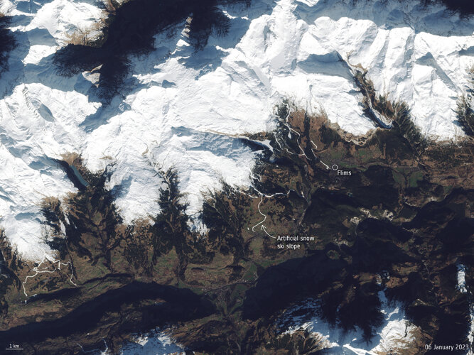 Image:
Europe has kicked off the new year with an intense winter heatwave. The warm temperatures and lack of snowfall in the Alps has left several ski resorts with little or no snow. The difference in snow cover is visible in these Copernicus Sentinel-2 images captured in January 2022 compared to January 2023.
Image:
Europe has kicked off the new year with an intense winter heatwave. The warm temperatures and lack of snowfall in the Alps has left several ski resorts with little or no snow. The difference in snow cover is visible in these Copernicus Sentinel-2 images captured in January 2022 compared to January 2023.
Snowless ski slopes from space
12.1.2023 12:00 ESA Observing the Earth
Image:
Snowless ski slopes from space
Týden velkých a otevřených dat. K vidění budou MapWhiteboard, Hub4Everybody, klimatický atlas, SensLog či nástroje umělé inteligence
12.1.2023 10:45 GeoBusinessPo tříleté covidové přestávce se v Praze uskuteční Týden velkých a otevřených dat a digitálních inovačních hubů. Do uspořádání akce se vedle sdružení Plan4all zapojily také další organizace, konkrétně Česká technologická platforma pro zemědělství, sdružení CzechInno, firmy WirelessInfo, České centrum pro vědu a společnost, Lesprojekt – služby a Help Service – Remote Sensing. Na akci […]
The post Týden velkých a otevřených dat. K vidění budou MapWhiteboard, Hub4Everybody, klimatický atlas, SensLog či nástroje umělé inteligence appeared first on GeoBusiness.
Týden velkých a otevřených dat. Podívejte se na klimatický atlas, SensLog či nástroje umělé inteligence
12.1.2023 10:45 GeoBusinessPo tříleté covidové přestávce se v Praze uskuteční Týden velkých a otevřených dat a digitálních inovačních hubů. Do uspořádání akce se vedle sdružení Plan4all zapojily také další organizace, konkrétně Česká technologická platforma pro zemědělství, sdružení CzechInno, firmy WirelessInfo, České centrum pro vědu a společnost, Lesprojekt – služby a Help Service – Remote Sensing. Na akci […]
The post Týden velkých a otevřených dat. Podívejte se na klimatický atlas, SensLog či nástroje umělé inteligence appeared first on GeoBusiness.
Rozpočet úřadu za rok 2023
12.1.2023 10:37 ČÚZK /Urady/Katastralni-urady/Katastralni-urady/Katastralni-urad-pro-Jihomoravsky-kraj/Rozpocet/Rozpocet-uradu-za-rok-2023Rozpočet úřadu za rok 2023
12.1.2023 10:37 ČÚZK - předpisy a opatření Katastrální úřad pro Jihomoravský krajvystavuje rozpočet úřadu za rok
2023
Mapová aplikace ÚPD - nové dokumentace
12.1.2023 8:23 Jihočeský krajV mapové aplikaci Územně plánovací dokumentace obcí byla aktualizována ÚPD obcí ORP Třeboň – Třeboň, ORP Blatná – Tchořovice, ORP Strakonice – Nebřehovice, ORP Tábor – Planá nad Lužnicí, Běleč.
Výběrové řízení na zahraniční studijní pobyty ERASMUS+
11.1.2023 18:39 Katedra geoinformatiky UP OlomoucKatedra vyhlašuje výběrové řízení na zahraniční studijní pobyty ERASMUS+. Podrobnější informace o zahraničních stážích včetně přehledu nabízených destinací jsou dostupné na https://www.geoinformatics.upol.cz/mobility . Přihlášení probíhá přes webovou aplikaci https://mobility.upol.cz/ . Termín pro přihlášení je 10. 2. 2023. V případě jakýchkoliv dotazů kontaktujte doc. Buriana. Jedná se o výjezdy, které se uskuteční v akademickém roce 2023/24 […]
The post Výběrové řízení na zahraniční studijní pobyty ERASMUS+ appeared first on Katedra geoinformatiky.
rada/odborný rada – rozhodování o povolení vkladu v oddělení právních vztahů k nemovitostem na Katas
11.1.2023 17:14 ČÚZK /Urady/Katastralni-urady/Katastralni-urady/Katastralni-urad-pro-Jihocesky-kraj/Uredni-deska/Oznameni-a-jina-uredni-sdeleni/Volna-mista/DMS/rada-odborny-rada-–-rozhodovani-o-povoleni-vkladu-rada/odborný rada – rozhodování o povolení vkladu v oddělení právních vztahů k nemovitostem na Katas
11.1.2023 17:14 ČÚZK - předpisy a opatření Katastrální úřad pro Jihočeský kraj Katastrální pracoviště Jindřichův Hradecvypisuje výběrové řízení na místo
rada/odborný rada – rozhodování o povolení vkladu v oddělení právních vztahů k nemovitostem na Katastrálním pracovišti Jindřichův Hradec
rada/odborný rada – rozhodování o povolení vkladu v oddělení právních vztahů k nemovitostem na Katas
11.1.2023 17:14 ČÚZK - volná místa Katastrální úřad pro Jihočeský kraj Katastrální pracoviště Jindřichův Hradec vypisuje výběrové řízení na místo rada/odborný rada – rozhodování o povolení vkladu v oddělení právních vztahů k nemovitostem na KatasRozpočet úřadu za rok 2023
11.1.2023 17:08 ČÚZK - předpisy a opatření Zeměměřický a katastrální inspektorát v Libercivystavuje rozpočet úřadu za rok
2023
Rozpočet úřadu za rok 2023
11.1.2023 17:08 ČÚZK /Urady/Zememericke-a-katastralni-inspektoraty/Zememericke-a-katastralni-inspektoraty/Zememericky-a-katastralni-inspektorat-v-Liberci/Rozpocet/Rozpocet-uradu-za-rok-2023rada/odborný rada - rozhodování o povolení vkladu v oddělení právních vztahů k nemovitostem na Katas
11.1.2023 16:25 ČÚZK /Urady/Katastralni-urady/Katastralni-urady/Katastralni-urad-pro-Jihocesky-kraj/Uredni-deska/Oznameni-a-jina-uredni-sdeleni/Volna-mista/DMS/rada-odborny-rada-rozhodovani-o-povoleni-vkladu-v-rada/odborný rada - rozhodování o povolení vkladu v oddělení právních vztahů k nemovitostem na Katas
11.1.2023 16:25 ČÚZK - volná místa Katastrální úřad pro Jihočeský kraj Katastrální pracoviště Jindřichův Hradec vypisuje výběrové řízení na místo rada/odborný rada - rozhodování o povolení vkladu v oddělení právních vztahů k nemovitostem na Katasrada/odborný rada - rozhodování o povolení vkladu v oddělení právních vztahů k nemovitostem na Katas
11.1.2023 16:25 ČÚZK - předpisy a opatření Katastrální úřad pro Jihočeský kraj Katastrální pracoviště Jindřichův Hradecvypisuje výběrové řízení na místo
rada/odborný rada - rozhodování o povolení vkladu v oddělení právních vztahů k nemovitostem na Katastrálním pracovišti Jindřichův Hradec
rada/odborný rada - rozhodování o povolení vkladu v oddělení právních vztahů k nemovitostem na Katas
11.1.2023 16:25 ČÚZK /Urady/Katastralni-urady/Katastralni-urady/Katastralni-urad-pro-Jihocesky-kraj/Uredni-deska/Oznameni-a-jina-uredni-sdeleni/Volna-mista/DMS/rada-odborny-rada-rozhodovani-o-povoleni-vkladu-vrada/odborný rada - rozhodování o povolení vkladu v oddělení právních vztahů k nemovitostem na Katas
11.1.2023 16:25 ČÚZK - volná místa Katastrální úřad pro Jihočeský kraj Katastrální pracoviště Jindřichův Hradec vypisuje výběrové řízení na místo rada/odborný rada - rozhodování o povolení vkladu v oddělení právních vztahů k nemovitostem na KatasZveřejnění obsahu informací poskytnutých na žádost dle zákona č. 106/1999 Sb. za rok 2023
11.1.2023 14:34 ČÚZK - předpisy a opatření Katastrální úřad pro Královéhradecký krajzveřejňuje obsah informace poskytnutých na žádost dle zákona č. 106/1999 Sb. za rok 2023
2023
Zveřejnění obsahu informací poskytnutých na žádost dle zákona č. 106/1999 Sb. za rok 2023
11.1.2023 14:34 ČÚZK /Urady/Katastralni-urady/Katastralni-urady/Katastralni-urad-pro-Kralovehradecky-kraj/Casto-hledane-informace/Poskytovani-informaci-106-1999-Sb/Zverejneni-obsahu-informaci-poskytnutych-na-za-(1)/Zverejneni-obsahu-informaci-poskytnutych-na-za-(4)2023 - Revize a nové mapování
11.1.2023 12:44 ČÚZK /Urady/Katastralni-urady/Katastralni-urady/Katastralni-urad-pro-Ustecky-kraj/Katastralni-pracoviste/KP-Louny/O-uradu/Aktuality/2023-Revize-a-nove-mapovani2023 - Revize a nové mapování
11.1.2023 12:44 ČÚZK - předpisy a opatření Český úřad zeměměřický a katastrální - Katastrální pracoviště Louny zveřejnil novou aktualitu: Vážení klienti, oznamujeme Vám, že v roce 2023 budou postupně probíhat revize katastru nemovitostí v katastrálních územích Solopysky, Břínkov (intravilán), Úlovice (intravilán), Dolní Ročov (mimo oblast pozemkové úpravy a mapování), Brodec, Smolnice u Loun, Divice. Předmětem revize jsou zejména zápisy staveb, druhu a způsobu využití pozemků, kdy výsledkem by mělo být dosažení co nejlepšího souladu katastru nemovitostí se skutečným stavem v terénu. O přesném termínu zahájení revize budete informováni obecním úřadem způsobem v místě obvyklém.Zároveň budou pokračovat měřické práce na novém mapování v k.ú. Horní Ročov. V 2.pololetí budou zahájeny přípravné práce pro nové mapování v k.ú. Libčeves a následně zjišťování průběhu hranic.
2023 - Revize a nové mapování
11.1.2023 12:44 ČÚZK - předpisy a opatření Katastrální úřad pro Ústecký kraj - Katastrální pracoviště Louny zveřejnil novou aktualitu: Vážení klienti, oznamujeme Vám, že v roce 2023 budou postupně probíhat revize katastru nemovitostí v katastrálních územích Solopysky, Břínkov (intravilán), Úlovice (intravilán), Dolní Ročov (mimo oblast pozemkové úpravy a mapování), Brodec, Smolnice u Loun, Divice. Předmětem revize jsou zejména zápisy staveb, druhu a způsobu využití pozemků, kdy výsledkem by mělo být dosažení co nejlepšího souladu katastru nemovitostí se skutečným stavem v terénu. O přesném termínu zahájení revize budete informováni obecním úřadem způsobem v místě obvyklém.Zároveň budou pokračovat měřické práce na novém mapování v k.ú. Horní Ročov. V 2.pololetí budou zahájeny přípravné práce pro nové mapování v k.ú. Libčeves a následně zjišťování průběhu hranic.
Zveřejnění obsahu informací poskytnutých na žádost dle zákona č. 106/1999 Sb. za rok 2023
11.1.2023 11:57 ČÚZK /Urady/Zememericke-a-katastralni-inspektoraty/Zememericke-a-katastralni-inspektoraty/Zememericky-a-katastralni-inspektorat-v-Opave/Casto-hledane-informace/Poskytovani-informaci-106-1999-Sb/Zverejneni-obsahu-informaci-poskytnutych-na-za-(1)/Zverejneni-obsahu-informaci-poskytnutych-na-za-(6)Zveřejnění obsahu informací poskytnutých na žádost dle zákona č. 106/1999 Sb. za rok 2023
11.1.2023 11:57 ČÚZK - předpisy a opatření Zeměměřický a katastrální inspektorát v Opavězveřejňuje obsah informace poskytnutých na žádost dle zákona č. 106/1999 Sb. za rok
2023
Výroční zpráva dle zákona č. 106/1999 Sb. za rok 2022
11.1.2023 11:39 ČÚZK - předpisy a opatření Zeměměřický a katastrální inspektorát v Opavěvydává výroční zprávu úřadu za rok
2022