


![]()

zprávy
zdroje zpráv:Nová aplikace Class Feeder pro klasifikování entit Revitu systémem CCI
9.12.2022 7:46 Arkance SystemsNová nadstavba z našeho vývoje pro efektivní klasifikaci prvků projektů Revitu fasetovým systémem CCI. Získejte ji zdarma do 30.6. 2023.
Zpráva Nová aplikace Class Feeder pro klasifikování entit Revitu systémem CCI pochází z arkance-systems.cz.
APGEO - APG podepsala memorandum o spolupráci s ČKA a ČKAIT
9.12.2022 1:00 Asociace podnikatelů v geomatice Na konferenci GEOMATIKA 2022 bylo podepsáno memorandum o spolupráci mezi APG, ČKA a ČKAIT.Kniha o Aretinově mapě českého království vyšla i anglicky! [Knihovna geografie, byTopic]
9.12.2022 0:00 Katedra aplikované geoinformatiky a kartografie Přf UK Po úspěšném českém vydání vydává nakladatelství Karolinum knihu o životním díle Pavla Aretina z Ehrenfeldu, mapě Novém a přesném popisu Království českého nyní i v anglické verzi.Knihovna geografie o vánočních svátcích [Knihovna geografie, byTopic]
9.12.2022 0:00 Katedra aplikované geoinformatiky a kartografie Přf UK Upozorňujeme naše čtenářky a čtenáře, že knihovna bude od 19.12.2022 do 1.1.2023 uzavřena.referent/vrchní referent – vedení katastrální mapy
8.12.2022 14:53 ČÚZK /Urady/Katastralni-urady/Katastralni-urady/Katastralni-urad-pro-hlavni-mesto-Prahu/Uredni-deska/Oznameni-a-jina-uredni-sdeleni/Volna-mista/DMS/referent-vrchni-referent-–-vedeni-katastralni-mapyreferent/vrchní referent – vedení katastrální mapy
8.12.2022 14:53 ČÚZK - volná místa Katastrální úřad pro hlavní město Prahu Katastrální pracoviště Praha vypisuje výběrové řízení na místo referent/vrchní referent – vedení katastrální mapyreferent/vrchní referent – vedení katastrální mapy
8.12.2022 14:53 ČÚZK - předpisy a opatření Katastrální úřad pro hlavní město Prahu Katastrální pracoviště Prahavypisuje výběrové řízení na místo
referent/vrchní referent – vedení katastrální mapy
Krátka správa č. 58/2022
8.12.2022 14:44 Komora geodetů a kartografů SRThe post Krátka správa č. 58/2022 appeared first on Komora geodetov a kartografov.
Krátka správa č. 58/2022
8.12.2022 14:44 Komora geodetů a kartografů SRThe post Krátka správa č. 58/2022 appeared first on Komora geodetov a kartografov.
Krátka správa č. 57/2022
8.12.2022 14:37 Komora geodetů a kartografů SRThe post Krátka správa č. 57/2022 appeared first on Komora geodetov a kartografov.
Krátka správa č. 57/2022
8.12.2022 14:37 Komora geodetů a kartografů SRThe post Krátka správa č. 57/2022 appeared first on Komora geodetov a kartografov.
odborný/vrchní referent v oddělení aktualizace katastru nemovitostí
8.12.2022 11:26 ČÚZK /Urady/Katastralni-urady/Katastralni-urady/Katastralni-urad-pro-Pardubicky-kraj/Uredni-deska/Oznameni-a-jina-uredni-sdeleni/Volna-mista/DMS/odborny-vrchni-referent-v-oddeleni-aktualizace-katodborný/vrchní referent v oddělení aktualizace katastru nemovitostí
8.12.2022 11:26 ČÚZK - volná místa Katastrální úřad pro Pardubický kraj Katastrální pracoviště Chrudim vypisuje výběrové řízení na místo odborný/vrchní referent v oddělení aktualizace katastru nemovitostíodborný/vrchní referent v oddělení aktualizace katastru nemovitostí
8.12.2022 11:26 ČÚZK - předpisy a opatření Katastrální úřad pro Pardubický kraj Katastrální pracoviště Chrudimvypisuje výběrové řízení na místo
odborný/vrchní referent v oddělení aktualizace katastru nemovitostí
20221208_Rada / odborný rada oddělení právních vztahů k nemovitostem
8.12.2022 11:15 ČÚZK /Urady/Katastralni-urady/Katastralni-urady/Katastralni-urad-pro-Stredocesky-kraj/Katastralni-pracoviste/KP-Pribram/O-uradu/Aktuality/20210922_Odborny-referent-oddeleni-aktualizace-(1)20221208_Rada / odborný rada oddělení právních vztahů k nemovitostem
8.12.2022 11:15 ČÚZK - předpisy a opatření Katastrální úřad pro Středočeský kraj - Katastrální pracoviště Příbram Vyhlášení výběrového řízení: Rada / odborný rada oddělení právních vztahů k nemovitostem V části "Úřední deska", v sekci "Oznámení a jiná úřední sdělení" bylo vystaveno "Oznámení o vyhlášení výběrového řízení na obsazení služebního místa Rada / odborný rada oddělení právních vztahů k nemovitostem"Aliance byla partnerem uzavřené konference Drony vládnou českému nebi na CIIRC ČVUT
8.12.2022 10:08 UAVAAliance pro bezpilotní letecký průmysl byla partnerem uzavřené konference Drony vládnou českému nebi na ČVUT CIIRC, které měla za účel více propojit civilní a armádní sektor v oblastech dronů. Konference se účastnilo mnoho zástupců státních organizací a Armády ČR a byla i diskuze o U-space a testovacím prostoru pro drony v ČR.
The post Aliance byla partnerem uzavřené konference Drony vládnou českému nebi na CIIRC ČVUT appeared first on UAV Aliance pro bezpilotní letecký průmysl.
Nabídka práce - Specialist(k)a analýz města
8.12.2022 0:00 Geografický ústav MUInstitut plánování a rozvoje hl. m. Prahy hledá nového kolegu či kolegyni na pozici specialist(k)a analýz města, přičemž jde o pozici vhodnou pro geografy - studenty magisterského nebo doktorského studia.
Inzerát je dostupný na webu https://cloud.iprpraha.cz/index.php/s/FiNdcQH1RLqFLur nebo na stránkách IPR Praha https://iprpraha.cz/kariera/specialista-specialistka-analyz-mesta.
MTG-I1 never to be seen again
7.12.2022 16:17 ESA Observing the Earth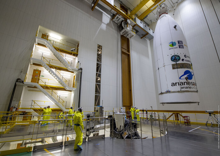
As preparations to launch Europe’s first Meteosat Third Generation Imager satellite continue, the team at Europe’s Spaceport in Kourou, French Guiana, has bid farewell to their precious satellite as it was sealed from view within the Ariane 5 rocket’s fairing. This all-new weather satellite is set to take to the skies on 13 December.
MTG-I1 never to be seen again
7.12.2022 16:17 ESA Observing the Earth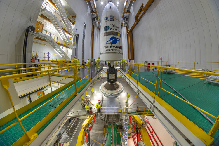
As preparations to launch Europe’s first Meteosat Third Generation Imager satellite continue, the team at Europe’s Spaceport in Kourou, French Guiana, has bid farewell to their precious satellite as it was sealed from view within the Ariane 5 rocket’s fairing. This all-new weather satellite is set to take to the skies on 13 December.
GEUS a novelizace katastrální vyhlášky k 1.1.2023
7.12.2022 15:57 GEUSware Dne 23. 11. 2022 byla ve Sbírce zákonů uveřejněna vyhláška č. 346/2022 Sb., kterou se mění vyhláška č. 357/2013 Sb., o katastru nemovitostí (katastrální vyhláška), ve znění pozdějších předpisů. Účinnost vyhlášky nastává dnem 1. 1. 2023 - viz stránky ČÚZK
V souvislostí s novou úpravou vyhlášky bude během prosince uvolněna nová verze GEUS 27.0.
Uživatelé se zaplacenou licenční podporou nemusí nic řešit a mohou pak začít ihned používat verzi 27.0.
Uživatelům verze 26.0 bez licenční podpory vyjdeme vstříc a základní změny požadované v nové úpravě KV promítneme do mimořádného sestavení i této verze. Budou však upraveny pouze tyto požadavky nové úpravy KV:
přidána značka "podrobný bod jiný zpřesněný (1,0mm)", včetně ořezu linií
doplněny způsoby ochrany nemovitostí (doplněny kódy 40 až 57)
Where Are All the Workers?
7.12.2022 14:52 Bentley SystemsNew data suggests the construction industry is adding new workers, but at a rather modest pace that may not be enough to fill in the gap left behind by a retiring workforce and those who left the industry during the height of the COVID-19 pandemic. Will it be enough? And how will we fill in the gap? I recently had a roundtable conversation that will help us answer some of these questions.
The post Where Are All the Workers? appeared first on Bentley Systems | Infrastructure Engineering Software Company.Where Are All the Workers?
7.12.2022 14:52 Bentley SystemsNew data suggests the construction industry is adding new workers, but at a rather modest pace that may not be enough to fill in the gap left behind by a retiring workforce and those who left the industry during the height of the COVID-19 pandemic. Will it be enough? And how will we fill in the gap? I recently had a roundtable conversation that will help us answer some of these questions.
The post Where Are All the Workers? appeared first on Bentley Systems | Infrastructure Engineering Software Company.How Software and Design Can Help Push the World Closer to Decarbonization
7.12.2022 14:52 Bentley SystemsBetter design would help reduce the collective emissions of offices and homes worldwide. After all, a building designed to be sustainable and efficient from day one will emit less carbon during its construction and later, its entire lifespan.
The post How Software and Design Can Help Push the World Closer to Decarbonization appeared first on Bentley Systems | Infrastructure Engineering Software Company.How Software and Design Can Help Push the World Closer to Decarbonization
7.12.2022 14:52 Bentley SystemsBetter design would help reduce the collective emissions of offices and homes worldwide. After all, a building designed to be sustainable and efficient from day one will emit less carbon during its construction and later, its entire lifespan.
The post How Software and Design Can Help Push the World Closer to Decarbonization appeared first on Bentley Systems | Infrastructure Engineering Software Company.Digital twins got a ‘kick in the pants’ during the pandemic, says Greg Bentley
7.12.2022 14:51 Bentley SystemsThe COVID-19 crisis has helped shape new launches from infrastructure engineering software firm
The post Digital twins got a ‘kick in the pants’ during the pandemic, says Greg Bentley appeared first on Bentley Systems | Infrastructure Engineering Software Company.Digital twins got a ‘kick in the pants’ during the pandemic, says Greg Bentley
7.12.2022 14:51 Bentley SystemsThe COVID-19 crisis has helped shape new launches from infrastructure engineering software firm
The post Digital twins got a ‘kick in the pants’ during the pandemic, says Greg Bentley appeared first on Bentley Systems | Infrastructure Engineering Software Company.Design and Construction Firms Must Embrace Digital Maturity to Improve Resilience
7.12.2022 14:51 Bentley SystemsFirms across Australia’s design and construction sector must work to improve their digital maturity to make their operations and businesses more resilient in the face of ongoing challenges, according to a technology leader says.
The post Design and Construction Firms Must Embrace Digital Maturity to Improve Resilience appeared first on Bentley Systems | Infrastructure Engineering Software Company.Design and Construction Firms Must Embrace Digital Maturity to Improve Resilience
7.12.2022 14:51 Bentley SystemsFirms across Australia’s design and construction sector must work to improve their digital maturity to make their operations and businesses more resilient in the face of ongoing challenges, according to a technology leader says.
The post Design and Construction Firms Must Embrace Digital Maturity to Improve Resilience appeared first on Bentley Systems | Infrastructure Engineering Software Company.Launches secured for five Sentinel satellites
7.12.2022 14:47 ESA Observing the Earth
A contract signed today between ESA and Arianespace has ensured rides into orbit for five Copernicus Sentinels: Sentinel-1D, Sentinel-2C, Sentinel-3C, and the Copernicus Anthropogenic Carbon Dioxide-A and -B satellites. All the satellites will be launched on Vega-C rockets from Europe’s Spaceport in French Guiana and are scheduled to take place between 2024 and 2026.
výběrové řízení na KÚ pro Vysočinu
7.12.2022 11:18 ČÚZK - předpisy a opatření Katastrální úřad pro Vysočinu zveřejnil novou aktualitu: Oznámení o vyhlášení výběrového řízení na služební místo rada/odborný rada v personálním oddělení Kanceláře ředitele katastrálního úřadu na Katastrálním úřadu pro Vysočinu.výběrové řízení na KÚ pro Vysočinu
7.12.2022 11:18 ČÚZK - předpisy a opatření Katastrální úřad pro Vysočinu zveřejnil novou aktualitu: Oznámení o vyhlášení výběrového řízení na služební místo rada/odborný rada v personálním oddělení Kanceláře ředitele katastrálního úřadu na Katastrálním úřadu pro Vysočinu.výběrové řízení na KÚ pro Vysočinu
7.12.2022 11:18 ČÚZK /Urady/Katastralni-urady/Katastralni-urady/Katastralni-urad-pro-Vysocinu/O-uradu/Aktuality/vyberove-rizeni-na-KU-pro-VysocinuDigitální technické mapy z pohledu správců a uživatelů (pozvánka)
7.12.2022 11:04 GISportal.cz
Ve středu 14.12.2022 od 9 do 13 hodin pořádá sdružení Nemoforum seminář na téma Digitální technické mapy z pohledu správců a uživatelů. Akce se koná v konferenčním sále budovy Zeměměřických a katastrálních úřadů v Praze 8 – Kobylisích. Semináře se lze zúčastnit přímo v místě konání – nebo se přihlásit k on-line účasti. Bližší informace o programu […]
The post Digitální technické mapy z pohledu správců a uživatelů (pozvánka) appeared first on GISportal.cz.
Digitální technické mapy z pohledu správců a uživatelů (pozvánka)
7.12.2022 11:04 GISportal.czVe středu 14.12.2022 od 9 do 13 hodin pořádá sdružení Nemoforum seminář na téma Digitální technické mapy z pohledu správců a uživatelů. Akce se koná v konferenčním sále budovy Zeměměřických a katastrálních úřadů v Praze 8 – Kobylisích. Semináře se lze zúčastnit přímo v místě konání – nebo se přihlásit k on-line účasti. Bližší informace o programu […]
The post Digitální technické mapy z pohledu správců a uživatelů (pozvánka) appeared first on GISportal.cz.
rada-odborný rada-personální oddělení- KŘKÚ
7.12.2022 10:49 ČÚZK - volná místa Katastrální úřad pro Vysočinu kancelář ředitele vypisuje výběrové řízení na místo rada-odborný rada-personální oddělení- KŘKÚrada-odborný rada-personální oddělení- KŘKÚ
7.12.2022 10:49 ČÚZK /Urady/Katastralni-urady/Katastralni-urady/Katastralni-urad-pro-Vysocinu/Uredni-deska/Oznameni-a-jina-uredni-sdeleni/Volna-mista/DMS/rada-odborny-rada-personalni-oddeleni-KRKUrada-odborný rada-personální oddělení- KŘKÚ
7.12.2022 10:49 ČÚZK - předpisy a opatření Katastrální úřad pro Vysočinu kancelář ředitelevypisuje výběrové řízení na místo
rada-odborný rada-personální oddělení- KŘKÚ
Výběrové řízení
7.12.2022 7:41 ČÚZK - předpisy a opatření Katastrální úřad pro Plzeňský kraj - Katastrální pracoviště Plzeň-sever zveřejnil novou aktualitu: Ředitelka Katastrálního úřadu pro Plzeňský kraj jako služební orgán příslušný podle § 10 odst. 1 písm. f) zákona č. 234/2014 Sb., o státní službě ve znění pozdějších předpisů (dále jen „zákon“), vyhlašuje výběrové řízení na služební místo odborný/vrchní referent – poskytování informací KN PIKN1103,oddělení dokumentace KN, Katastrální úřad pro Plzeňský kraj, Katastrální pracoviště Plzeň - sever, v oboru služby 55. Zeměměřictví a katastr nemovitostí.Výběrové řízení odborný/vrchní referent KP Plzeň-sever
7.12.2022 7:36 ČÚZK - volná místa Katastrální úřad pro Plzeňský kraj Katastrální pracoviště Plzeň-sever vypisuje výběrové řízení na místo Výběrové řízení odborný/vrchní referent KP Plzeň-severVýběrové řízení odborný/vrchní referent KP Plzeň-sever
7.12.2022 7:36 ČÚZK /Urady/Katastralni-urady/Katastralni-urady/Katastralni-urad-pro-Plzensky-kraj/Uredni-deska/Oznameni-a-jina-uredni-sdeleni/Volna-mista/DMS/Vyberove-rizeni-odborny-vrchni-referent-KP-Plzen-sVýběrové řízení odborný/vrchní referent KP Plzeň-sever
7.12.2022 7:36 ČÚZK - předpisy a opatření Katastrální úřad pro Plzeňský kraj Katastrální pracoviště Plzeň-severvypisuje výběrové řízení na místo
Výběrové řízení odborný/vrchní referent KP Plzeň-sever
Pozvánka na přednášku Atmospheric ozone dynamics and the last depletion events in the Arctic
7.12.2022 0:00 Geografický ústav MU
Nabídka práce - Referent/ka v oddělení řízení strategie regionálního rozvoje (MMR ČR)
7.12.2022 0:00 Geografický ústav MUInzerát ze dne 6. 12. 2022 zveřejněný na úřední desce MMR:
22. jednání KRS
6.12.2022 19:00 ČÚZK - předpisy a opatření Dne 21. prosince 2022 proběhne distančně 22. jednání Koordinační rady správců DMVS a DTM.Omezení aktuálnosti dat DP a WSDP v pátek 9.12.2022 od 14:30 do cca 19:00.
6.12.2022 15:23 Dálkový přístup k údajům KN ČR Vážení uživatelé,oznamujeme, že v pátek 9.12.2022 od 14:30 bude z provozních důvodů zastavena aktualizace údajů Dálkového přístupu i Webových služeb dálkového přístupu. Obnovení standardního provozu předpokládáme v cca 19 hodin.
Za komplikace tímto způsobené se omlouváme a děkujeme za pochopení.
Omezení aktuálnosti dat DP a WSDP v pátek 9.12.2022 od 14:30 do cca 19:00.
6.12.2022 15:23 ČÚZK /Aplikace-DP-do-KN/Aplikace-DP-do-KN/Archiv-DP/372758Omezení aktuálnosti dat DP a WSDP v pátek 9.12.2022 od 14:30 do cca 19:00.
6.12.2022 15:23 ČÚZK - předpisy a opatření Vážení uživatelé,oznamujeme, že v pátek 9.12.2022 od 14:30 bude z provozních důvodů zastavena aktualizace údajů Dálkového přístupu i Webových služeb dálkového přístupu. Obnovení standardního provozu předpokládáme v cca 19 hodin.
Za komplikace tímto způsobené se omlouváme a děkujeme za pochopení.
Coming soon: MTG The Next Generation
6.12.2022 15:10 ESA Observing the Earth Video:
00:00:48
Video:
00:00:48
One week today, the first of a new generation of weather satellites will take to the skies. The Meteosat Third Generation system is the most complex and innovative meteorological satellite system ever built. It will bring new capabilities to monitor weather, climate and the environment from space like never before – promising to further bolster Europe’s leadership in weather forecasting.
Join us for the live launch coverage of the Metetosat Third Generation Imager on 13 December on ESA Web TV.
Animations provided by Mlabspace
Coming soon: MTG The Next Generation
6.12.2022 15:10 ESA Observing the Earth
Video:
00:00:48
One week today, the first of a new generation of weather satellites will take to the skies. The Meteosat Third Generation system is the most complex and innovative meteorological satellite systems ever built. It will bring new capabilities to monitor weather, climate and the environment from space like never before – promising to further bolster Europe’s leadership in weather forecasting.
Join us for the live launch coverage of the Metetosat Third Generation Imager on 13 December on ESA Web TV.
Coming soon: MTG The Next Generation
6.12.2022 15:10 ESA Observing the Earth
Video:
00:00:48
One week today, the first of a new generation of weather satellites will take to the skies. The Meteosat Third Generation system is the most complex and innovative meteorological satellite system ever built. It will bring new capabilities to monitor weather, climate and the environment from space like never before – promising to further bolster Europe’s leadership in weather forecasting.
Join us for the live launch coverage of the Metetosat Third Generation Imager on 13 December on ESA Web TV.
Aktualizujte si VFR Import
6.12.2022 14:55 ARCDATAData RÚIAN publikovaná Zeměměřickým úřadem budou od 1. 1. 2023 poskytována ve verzi RÚIAN 3.5, která do dat Orp přináší nový atribut Vusc. Tato změna se promítne i do datového modelu nástroje VFR Import. Vydáváme proto novou verzi VFR Import 3.0.4, která datový model upraví a bude připravená s novou verzí dat pracovat. Nezapomeňte si tak nástroj VFR Import co nejdříve aktualizovat.
Na stránce nástroje VFR Import si můžete stáhnout bezplatnou základní verzi a dozvědět se, co vše obsahuje plná verze nástroje.
Nová verze VFR Import 3.0.4
Datový model
- Přidání atributu Vusc do třídy prvků Orp.
- Přidání relační třídy mezi třídami prvků Vusc a Orp.
Dokumentace
- Popis licencování ArcGIS Pro při automatickém plánovaném spouštění.
Opraveno
- Chyba při vkládání vyšších územních celků při aktualizaci.
- Vytváření geometrie, i když jsou na vstupu duplicitní body.
Důležitá informace pro aktualizaci datového modelu
VFR Import 3.0.4 přidá atribut Vusc do třídy prvků Orp automaticky sám, pokud v danou chvíli nebudou na datovém modelu zámky od jiných uživatelů, např. zámky ze serverových služeb apod. V případě, že se nástroji nepodaří získat exkluzivní zámek pro vytvoření atributu, skončí chybou. V takovém případě můžete atribut Vusc (long integer) ve třídě Orp vytvořit sami manuálně, až bude možné získat exkluzivní zámek.
výběrové řízení na KP Jihlava
6.12.2022 14:10 ČÚZK - předpisy a opatření Katastrální úřad pro Vysočinu - Katastrální pracoviště Jihlava zveřejnil novou aktualitu: Oznámení o vyhlášení výběrového řízení na služební místo rada/odborný rada – vedoucí oddělení dokumentace KN Katastrálního pracoviště Jihlava na Katastrálním úřadu pro Vysočinu.Čestné prohlášení - funkční příloha.
výběrové řízení na KP Jihlava
6.12.2022 14:10 ČÚZK /Urady/Katastralni-urady/Katastralni-urady/Katastralni-urad-pro-Vysocinu/O-uradu/Aktuality/vyberove-rizeni-na-KP-Jihlava-(2)výběrové řízení na KP Jihlava
6.12.2022 14:10 ČÚZK - předpisy a opatření Katastrální úřad pro Vysočinu - Katastrální pracoviště Jihlava zveřejnil novou aktualitu: Oznámení o vyhlášení výběrového řízení na služební místo rada/odborný rada – vedoucí oddělení dokumentace KN Katastrálního pracoviště Jihlava na Katastrálním úřadu pro Vysočinu.rada-odborný rada - vedoucí oddělení dokumentace KN - KP Jihlava
6.12.2022 14:00 ČÚZK /Urady/Katastralni-urady/Katastralni-urady/Katastralni-urad-pro-Vysocinu/Uredni-deska/Oznameni-a-jina-uredni-sdeleni/Volna-mista/DMS/rada-odborny-rada-vedouci-oddeleni-dokumentace-KN-rada-odborný rada - vedoucí oddělení dokumentace KN - KP Jihlava
6.12.2022 14:00 ČÚZK - volná místa Katastrální úřad pro Vysočinu Katastrální pracoviště Jihlava vypisuje výběrové řízení na místo rada-odborný rada - vedoucí oddělení dokumentace KN - KP Jihlavarada-odborný rada - vedoucí oddělení dokumentace KN - KP Jihlava
6.12.2022 14:00 ČÚZK - předpisy a opatření Katastrální úřad pro Vysočinu Katastrální pracoviště Jihlavavypisuje výběrové řízení na místo
rada-odborný rada - vedoucí oddělení dokumentace KN - KP Jihlava
Krátka správa č. 56/2022
6.12.2022 13:32 Komora geodetů a kartografů SRThe post Krátka správa č. 56/2022 appeared first on Komora geodetov a kartografov.
Vrchni referent/rada v oddělení aktualizace PI KN na Katastrálním pracovišti Brno - město
6.12.2022 10:39 ČÚZK - volná místa Katastrální úřad pro Jihomoravský kraj Katastrální pracoviště Brno-město vypisuje výběrové řízení na místo Vrchni referent/rada v oddělení aktualizace PI KN na Katastrálním pracovišti Brno - městoVrchni referent/rada v oddělení aktualizace PI KN na Katastrálním pracovišti Brno - město
6.12.2022 10:39 ČÚZK - předpisy a opatření Katastrální úřad pro Jihomoravský kraj Katastrální pracoviště Brno-městovypisuje výběrové řízení na místo
Vrchni referent/rada v oddělení aktualizace PI KN na Katastrálním pracovišti Brno - město
Vrchni referent/rada v oddělení aktualizace PI KN na Katastrálním pracovišti Brno - město
6.12.2022 10:39 ČÚZK /Urady/Katastralni-urady/Katastralni-urady/Katastralni-urad-pro-Jihomoravsky-kraj/Volna-mista/DMS/Vrchni-referent-rada-v-oddeleni-aktualizace-PI-KN-221206-Sbírka zákonů
6.12.2022 8:55 ČÚZK - aktuality v resortu Dne 23. 11. 2022 byla ve Sbírce zákonů uveřejněna vyhláška č. 346/2022 Sb., kterou se mění vyhláška č. 357/2013 Sb., o katastru nemovitostí (katastrální vyhláška), ve znění pozdějších předpisů . Účinnost vyhlášky nastává dnem 1. 1. 2023.221206-Sbírka zákonů
6.12.2022 8:55 ČÚZK - předpisy a opatření Český úřad zeměměřický a katastrální zveřejnil novou aktualitu: Dne 23. 11. 2022 byla ve Sbírce zákonů uveřejněna vyhláška č. 346/2022 Sb., kterou se mění vyhláška č. 357/2013 Sb., o katastru nemovitostí (katastrální vyhláška), ve znění pozdějších předpisů . Účinnost vyhlášky nastává dnem 1. 1. 2023.APGEO - Představujeme: Video o BIM
6.12.2022 1:00 Asociace podnikatelů v geomatice APG představila nové video k problematice BIM.Zimní údržba pod dozorem. Pro ŘSD ji kontroluje systém od VARS
6.12.2022 1:00 VARS.czZatěžkávací zkoušku v letošní zimní sezoně má za sebou systém
ISUDaS. Softwarové řešení vyvinuté VARS BRNO dohlíží nad prací zimní údržby na
dálnicích a silnicích ve správě Ředitelství silnic a dálnic. Dokáže pohlídat,
jestli dodavatelské firmy, které pro ŘSD silnice ošetřují, skutečně práci
odvedli A dokonce i to, jestli odpovídala počasí, které zrovna bylo.
20221205_zásobovač
5.12.2022 17:13 ČÚZK - předpisy a opatření Katastrální úřad pro Středočeský kraj Vyhlášení výběrového řízení: zásobovač V části "Úřední deska", v sekci "Oznámení a jiná úřední sdělení" bylo vystaveno "Oznámení o vyhlášení výběrového řízení na obsazení služebního místa zásobovač"20221205_zásobovač
5.12.2022 17:13 ČÚZK /Urady/Katastralni-urady/Katastralni-urady/Katastralni-urad-pro-Stredocesky-kraj/O-uradu/Aktuality/20210922_Odborny-referent-oddeleni-aktualizace-(7)zásobovač
5.12.2022 17:12 ČÚZK /Urady/Katastralni-urady/Katastralni-urady/Katastralni-urad-pro-Stredocesky-kraj/Uredni-deska/Oznameni-a-jina-uredni-sdeleni/Volna-mista/DMS/zasobovaczásobovač
5.12.2022 17:12 ČÚZK - předpisy a opatření Katastrální úřad pro Středočeský kraj kancelář úřaduvypisuje výběrové řízení na místo
zásobovač
zásobovač
5.12.2022 17:12 ČÚZK - volná místa Katastrální úřad pro Středočeský kraj kancelář úřadu vypisuje výběrové řízení na místo zásobovač20221205_odborný referent v oddělení dokumentace KN
5.12.2022 17:07 ČÚZK /Urady/Katastralni-urady/Katastralni-urady/Katastralni-urad-pro-Stredocesky-kraj/Katastralni-pracoviste/KP-Rakovnik/O-uradu/Aktuality/20210922_Odborny-referent-oddeleni-aktualizace-(5)20221205_odborný referent v oddělení dokumentace KN
5.12.2022 17:07 ČÚZK - předpisy a opatření Katastrální úřad pro Středočeský kraj - Katastrální pracoviště Rakovník Vyhlášení výběrového řízení: odborný referent v oddělení dokumentace KN V části "Úřední deska", v sekci "Oznámení a jiná úřední sdělení" bylo vystaveno "Oznámení o vyhlášení výběrového řízení na obsazení služebního místa odborný referent v oddělení dokumentace KN"odborný referent v oddělení dokumentace KN
5.12.2022 17:05 ČÚZK /Urady/Katastralni-urady/Katastralni-urady/Katastralni-urad-pro-Stredocesky-kraj/Uredni-deska/Oznameni-a-jina-uredni-sdeleni/Volna-mista/DMS/odborny-referent-v-oddeleni-dokumentace-KNodborný referent v oddělení dokumentace KN
5.12.2022 17:05 ČÚZK - volná místa Katastrální úřad pro Středočeský kraj Katastrální pracoviště Rakovník vypisuje výběrové řízení na místo odborný referent v oddělení dokumentace KNodborný referent v oddělení dokumentace KN
5.12.2022 17:05 ČÚZK - předpisy a opatření Katastrální úřad pro Středočeský kraj Katastrální pracoviště Rakovníkvypisuje výběrové řízení na místo
odborný referent v oddělení dokumentace KN
EUSPA welcomes excited delegates of the SME Assembly 2022
5.12.2022 16:16 European GNSS Agency
Taking place in Prague, from 28 to 30 November 2022, the 2022 SME Assembly is the most significant event for small and medium-sized enterprises (SMEs) in Europe. The conference is held once a year during the European SME Week. Together with the network of SME envoys, the assembly creates the governance structure of the Small Business Act.
This year’s SME Assembly included discussions and workshops about how the EU Space Programme enables companies to improve their operations, level-up and increase their return on investment.
The delegates of the Assembly enjoyed an exciting visit to our EUSPA headquarters where they were welcomed by the Executive Director, Rodrigo da Costa. Market Development and Innovation professionals familiarised themselves with the funding opportunities that the agency offers.
"The true impact of space data and services is felt with downstream, and SMEs and start-ups are at the heart of the EU economy. At EUSPA, our role is to provide to non-traditionally space companies the means to innovate by using Galileo/EGNOS, Copernicus and in the future satellite communications’’ says Fiammetta Diani, Head of MDI at EUSPA.
EUSPA’s support of the European SMES’ ecosystem goes beyond funding to include GNSS and Earth Observation market intelligence, mentoring and knowledge sharing through the CASSINI activities for instance and other platforms like the EUSPA Space Academy.
With the promotion of Copernicus on board since 2021, the agency’s efforts also focus on engaging with new commercial and private bodies, research, and education organisations charities. SMEs are central part of this new strategy for Earth Observation which is why over the past EUSPA launched a call for new Copernicus demonstrators for Mobility, Emergency and Infrastructures, among others.
SMEs to clean up the ocean using space!
Of the 300 million tonnes of plastic produced every year, an estimated 26 million eventually ends up in the ocean. As a result, some estimates suggest there are now 5.25 trillion pieces of plastic in our oceans and seas.
The Maritime CASSINI Prize for Digital Space Apps is looking for innovative commercial solutions that leverage the EU Space Programme to detect, monitor and remove plastics, microplastics and other litter from our oceans and waterways. With a total prize purse of EUR 2.85 million, the top three proposals are eligible to win EUR 0.95 million each, which can be used to help further develop and commercialise your solution.
Because the contest aims to create a new ecosystem of entrepreneurs, applications are only open to SMEs. All proposed solutions must be close-to-market and be able to prove their effectiveness in a real-world demonstration.
The prize is foreseen as part of the Horizon Europe Work Programme.
More information can be found here.
Media note: This feature can be republished without charge provided the European Union Agency for the Space Programme (EUSPA) is acknowledged as the source at the top or the bottom of the story. You must request permission before you use any of the photographs on the site. If you republish, we would be grateful if you could link back to the EUSPA website (http://www.euspa.europa.eu).
EUSPA welcomes excited delegates of the SME Assembly 2022
5.12.2022 16:16 European GNSS AgencyTaking place in Prague, from 28 to 30 November 2022, the 2022 SME Assembly is the most significant event for small and medium-sized enterprises (SMEs) in Europe. The conference is held once a year during the European SME Week. Together with the network of SME envoys, the assembly creates the governance structure of the Small Business Act.
This year’s SME Assembly included discussions and workshops about how the EU Space Programme enables companies to improve their operations, level-up and increase their return on investment.
The delegates of the Assembly enjoyed an exciting visit to our EUSPA headquarters where they were welcomed by the Executive Director, Rodrigo da Costa. Market Development and Innovation professionals familiarised themselves with the funding opportunities that the agency offers.
"The true impact of space data and services is felt with downstream, and SMEs and start-ups are at the heart of the EU economy. At EUSPA, our role is to provide to non-traditionally space companies the means to innovate by using Galileo/EGNOS, Copernicus and in the future satellite communications’’ says Fiammetta Diani, Head of MDI at EUSPA.
EUSPA’s support of the European SMES’ ecosystem goes beyond funding to include GNSS and Earth Observation market intelligence, mentoring and knowledge sharing through the CASSINI activities for instance and other platforms like the EUSPA Space Academy.
With the promotion of Copernicus on board since 2021, the agency’s efforts also focus on engaging with new commercial and private bodies, research, and education organisations charities. SMEs are central part of this new strategy for Earth Observation which is why over the past EUSPA launched a call for new Copernicus demonstrators for Mobility, Emergency and Infrastructures, among others.
SMEs to clean up the ocean using space!
Of the 300 million tonnes of plastic produced every year, an estimated 26 million eventually ends up in the ocean. As a result, some estimates suggest there are now 5.25 trillion pieces of plastic in our oceans and seas.
The Maritime CASSINI Prize for Digital Space Apps is looking for innovative commercial solutions that leverage the EU Space Programme to detect, monitor and remove plastics, microplastics and other litter from our oceans and waterways. With a total prize purse of EUR 2.85 million, the top three proposals are eligible to win EUR 0.95 million each, which can be used to help further develop and commercialise your solution.
Because the contest aims to create a new ecosystem of entrepreneurs, applications are only open to SMEs. All proposed solutions must be close-to-market and be able to prove their effectiveness in a real-world demonstration.
The prize is foreseen as part of the Horizon Europe Work Programme.
More information can be found here.
Media note: This feature can be republished without charge provided the European Union Agency for the Space Programme (EUSPA) is acknowledged as the source at the top or the bottom of the story. You must request permission before you use any of the photographs on the site. If you republish, we would be grateful if you could link back to the EUSPA website (http://www.euspa.europa.eu).
Replay: MTG-I1 pre-launch briefing
5.12.2022 15:51 ESA Observing the Earth Video:
00:43:38
Video:
00:43:38
Watch the replay of the Meteosat Third Generation Imager-1 pre-launch press briefing held on 5 December 2022. Speakers include Simonetta Cheli, ESA’s Director of Earth Observation Programmes; Phil Evans, Director General of Eumetsat; Bertrand Denis, Vice President Observation and Science at Thales Alenia Space and Simon Keogh, Head of Space Applications and Nowcasting Research & Development at the UK Met Office.
MTG-I1 is scheduled to be launched on 13 December on an Ariane 5 rocket from Europe’s Spaceport in French Guiana. It is the first of six satellites that form the full MTG system, which will provide critical data for weather forecasting over the next 20 years. In full operations, the mission will comprise two MTG-I satellites and one MTG Sounding (MTG-S) satellites working in tandem.
The MTG-I satellites carry two completely new instruments, a Flexible Combined Imager and Europe’s first Lightning Imager, to deliver high-quality data for better weather forecasting.
Replay: MTG-I1 pre-launch briefing
5.12.2022 15:51 ESA Observing the Earth
Video:
00:00:00
Watch the replay of the Meteosat Third Generation Imager-1 pre-launch press briefing held on 5 December 2022. Speakers include Simonetta Cheli, ESA’s Director of Earth Observation Programmes; Phil Evans, Director General of Eumetsat; Bertrand Denis, Vice President Observation and Science at Thales Alenia Space and Simon Keogh, Head of Space Applications and Nowcasting Research & Development at the UK Met Office.
MTG-I1 is scheduled to be launched on 13 December on an Ariane 5 rocket from Europe’s Spaceport in French Guiana. It is the first of six satellites that form the full MTG system, which will provide critical data for weather forecasting over the next 20 years. In full operations, the mission will comprise two MTG-I satellites and one MTG Sounding (MTG-S) satellites working in tandem.
The MTG-I satellites carry two completely new instruments, a Flexible Combined Imager and Europe’s first Lightning Imager, to deliver high-quality data for better weather forecasting.
Watch now: MTG-I1 pre-launch press briefing
5.12.2022 15:15 ESA Observing the Earth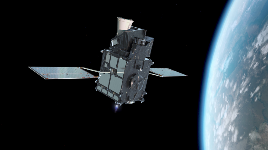
Watch now: MTG-I1 pre-launch press briefing
Our doors are open on 9-10 December, so visit us and explore the EU Space Programme!
5.12.2022 15:07 European GNSS Agency
The days are getting shorter, the temperatures colder – making it the perfect time to come inside and learn about the EU Space Programme. So, on 9 – 10 December, take one of Prague’s Galileo-enabled trams and make your way over to EUSPA Headquarters for our annual Open Days!
“After two years of virtual and outdoor events, we are thrilled to be able to once again open our doors to the public,” says EUSPA Executive Director Rodrigo da Costa. “A highlight on our agenda, the Open Days event is a unique opportunity for EU citizens to explore the Agency, learn about our mission and discover the many benefits of the EU Space Programme.”
With the theme ‘See, Navigate, Communicate’, this year’s edition shines the spotlight on how Galileo, EGNOS, Copernicus, GOVSATCOM and Space Situational Awareness all bring added value to our everyday lives. “Put these programmes together as one EU Space Programme and you unleash an array of synergies and possibilities, all of which have a powerful impact on society and the planet,” adds da Costa.
Coming on the heels of the United Nations Climate Change Conference, Open Days will have a particular focus on how EU Space contributes to fighting climate change and achieving such European goals as the Green Deal. During the event visitors can learn how EGNSS and Earth Observation support everything from selecting the best location for building renewable energy infrastructure, implementing the most fuel-efficient flight paths, monitoring CO2 emissions, designing efficient and autonomous transportation networks and increasing agricultural yields to sustainably feed a growing population.
Immersive experiences and virtual reality games
As EUSPA works to reduce its own footprint by limiting paper use and waste, the event will present information largely through digital exhibits. Our immersive Copernicus experience invites visitors to walk through a collage of colourful Earth Observation images taken from around the world.
The two-day event will also feature fun learning opportunities, exciting seminars, a hands-on space workshop and special activities for children, along with a number of competitions and prizes. And did we mention space simulators and virtual reality games?
“Whether it be determining how to achieve the world’s climate goals, respond to natural disasters, or build the smart cities and mobility systems of tomorrow, as these exhibits and presentations make clear, the answer can often be found in space,” says da Costa.
For those interested in learning about a possible career in space or about EUSPA’s various funding and support initiatives for entrepreneurs and businesses, be sure mark your calendar for 9-10 December. EUSPA experts will be giving talks and be available to answer your questions throughout the day.
A lot to celebrate!
This year’s event coincides with the Czech Presidency of the Council of the European Union and the 10th anniversary of EUSPA headquarters calling Prague home. In the decade since its move to Prague, EUSPA has provided significant funding to start-ups, SMEs, enterprises and research projects, many of which are making substantial contributions to the EU’s robust space economy.
Open Days 2022 will take place Friday and Saturday, 9 – 10 December, from 09:00 to 18:00 at EUSPA Headquarters, located at Janovského 438/2, 170 00 Praha 7-Holešovice.
Schools and universities interested in organising class visits on 9 December can still reserve a timeslot here.
Learn more at: https://www.euspa.europa.eu/euspa-open-days-2022
Media note: This feature can be republished without charge provided the European Union Agency for the Space Programme (EUSPA) is acknowledged as the source at the top or the bottom of the story. You must request permission before you use any of the photographs on the site. If you republish, we would be grateful if you could link back to the EUSPA website (http://www.euspa.europa.eu).
Nedostupné produkční ISÚI a VDP
5.12.2022 14:18 ČÚZK /ruian/Editacni-agendovy-system-ISUI/Provozni-informace-a-odstavky/Archiv-PROD/Nedostupne-produkcni-ISUI-a-VDP-(2)Upozornění k platbám 2022
5.12.2022 14:04 ČÚZK - předpisy a opatření Katastrální úřad pro Plzeňský kraj - Katastrální pracoviště Tachov zveřejnil novou aktualitu: Katastrální úřad pro Plzeňský kraj upozorňuje na změnu režimu v úhradách plateb správních poplatků v závěru roku 2022.Upozornění k platbám 2022
5.12.2022 14:04 ČÚZK /Urady/Katastralni-urady/Katastralni-urady/Katastralni-urad-pro-Plzensky-kraj/Katastralni-pracoviste/KP-Tachov/O-uradu/Aktuality/Upozorneni-k-platbam-2022Upozornění k platbám 2022
5.12.2022 14:02 ČÚZK /Urady/Katastralni-urady/Katastralni-urady/Katastralni-urad-pro-Plzensky-kraj/Katastralni-pracoviste/KP-Rokycany/O-uradu/Aktuality/Upozorneni-k-platbam-2022Upozornění k platbám 2022
5.12.2022 14:02 ČÚZK - předpisy a opatření Katastrální úřad pro Plzeňský kraj - Katastrální pracoviště Rokycany zveřejnil novou aktualitu: Katastrální úřad pro Plzeňský kraj upozorňuje na změnu režimu v úhradách plateb správních poplatků v závěru roku 2022.Upozornění k platbám 2022
5.12.2022 14:00 ČÚZK /Urady/Katastralni-urady/Katastralni-urady/Katastralni-urad-pro-Plzensky-kraj/Katastralni-pracoviste/KP-Plzen-sever/O-uradu/Aktuality/Upozorneni-k-platbam-2022Upozornění k platbám 2022
5.12.2022 14:00 ČÚZK - předpisy a opatření Katastrální úřad pro Plzeňský kraj - Katastrální pracoviště Plzeň-sever zveřejnil novou aktualitu: Katastrální úřad pro Plzeňský kraj upozorňuje na změnu režimu v úhradách plateb správních poplatků v závěru roku 2022.Upozornění k platbám 2022
5.12.2022 13:58 ČÚZK - předpisy a opatření Katastrální úřad pro Plzeňský kraj - Katastrální pracoviště Plzeň-město zveřejnil novou aktualitu: Katastrální úřad pro Plzeňský kraj upozorňuje na změnu režimu v úhradách plateb správních poplatků v závěru roku 2022.Upozornění k platbám 2022
5.12.2022 13:58 ČÚZK /Urady/Katastralni-urady/Katastralni-urady/Katastralni-urad-pro-Plzensky-kraj/Katastralni-pracoviste/KP-Plzen-mesto/O-uradu/Aktuality/Upozorneni-k-platbam-2022Upozornění k platbám 2022
5.12.2022 13:57 ČÚZK /Urady/Katastralni-urady/Katastralni-urady/Katastralni-urad-pro-Plzensky-kraj/Katastralni-pracoviste/KP-Plzen-jih/O-uradu/Aktuality/Upozorneni-k-platbam-2022Upozornění k platbám 2022
5.12.2022 13:57 ČÚZK - předpisy a opatření Katastrální úřad pro Plzeňský kraj - Katastrální pracoviště Plzeň-jih zveřejnil novou aktualitu: Katastrální úřad pro Plzeňský kraj upozorňuje na změnu režimu v úhradách plateb správních poplatků v závěru roku 2022.Upozornění k platbám 2022
5.12.2022 13:55 ČÚZK - předpisy a opatření Katastrální úřad pro Plzeňský kraj - Katastrální pracoviště Kralovice zveřejnil novou aktualitu: Katastrální úřad pro Plzeňský kraj upozorňuje na změnu režimu v úhradách plateb správních poplatků v závěru roku 2022.Upozornění k platbám 2022
5.12.2022 13:52 ČÚZK - předpisy a opatření Katastrální úřad pro Plzeňský kraj - Katastrální pracoviště Klatovy zveřejnil novou aktualitu: Katastrální úřad pro Plzeňský kraj upozorňuje na změnu režimu v úhradách plateb správních poplatků v závěru roku 2022.Upozornění k platbám 2022
5.12.2022 13:50 ČÚZK - předpisy a opatření Katastrální úřad pro Plzeňský kraj - Katastrální pracoviště Domažlice zveřejnil novou aktualitu: Katastrální úřad pro Plzeňský kraj upozorňuje na změnu režimu v úhradách plateb správních poplatků v závěru roku 2022.Mapová aplikace ÚPD - nové dokumentace
5.12.2022 13:24 Jihočeský krajV mapové aplikaci Územně plánovací dokumentace obcí byla aktualizována ÚPD obcí ORP Milevsko – Veselíčko, ORP Český Krumlov – Mirkovice, Přídolí, ORP Prachatice – Lhenice, Vlachovo Březí, ORP Týn nad Vltavou – Hosty.
Digitalizace udává nový směr stavebnictví
5.12.2022 13:08 czBIMŠancí pro budoucnost stavebnictví je digitalizace. Shodli se na tom zástupci stavebního sektoru Evropské unie a dalších evropských zemí na dvoudenní pražské konferenci Digital Construction...
Článek Digitalizace udává nový směr stavebnictví se nejdříve objevil na czBIM.
La Réunion EU MEOLUT, a cornerstone new infrastructure for SAR Galileo delivery in the Indian Ocean
5.12.2022 12:30 European GNSS Agency
From 1982 to 2022, 40 years of lives saved by Cospas-Sarsat
Amidst the celebration of the 40th anniversary of the first use of satellite technologies by Search and Rescue (SAR) forces earmarked on 10 September 1982 as well as the 40th anniversary of uninterrupted SAR operations of the French Mission Control Center (FMCC), the SAR/Galileo is enlarging its contribution to the Cospas-Sarsat (C/S) system of international SAR efforts cooperation with a fourth MEOLUT (Medium Earth Orbit Local User Terminals) facility deployed in the Indian ocean La Reunion island.
SAR/Galileo Services were designed to support the Cospas-Sarsat (C/S) in the context of the MEOSAR system (Medium Earth Orbit Search And Rescue) providing uninterrupted Search and Rescue services globally which account for more than 2,000 lives saved a year.
Galileo is already the largest ground (in terms of MEOLUTs) and space segment (L-band SAR payloads) provider within C/S in addition to being the only offering exclusively the Return Link Service (RLS).
Galileo SAR MEOLUTs Key Components of the SAR Ground Segment
La Reunion/ EU MEOLUT facility has been installed in an Orange Site at Rivière-Des-Pluies in the French La Reunion island in close vicinity of a combined Uplink Station (ULS) and Ground Sensor Station (GSS) existing Galileo remote site. The new MEOLUT successfully passed the required C/s commissioning tests and started providing operational alert data to the French Mission Control Center (FMCC) in a coverage area equivalent to a circle of a radius of 2,500 km for the first-generation C/S beacons and ELT(DT) detection coverage area of a radius of 6,000 km.
Further to the commissioning activities already performed, the MEOLUT is soon to undergo a dedicated SAR/Galileo service validation phase before fully being an integral part of the SAR/Galileo Ground Segment and becoming the fourth EU MEOLUT joining the three already operational located in Larnaca (Cyprus), Maspalomas (Spain) and Spitsbergen (Norway).
Galileo instrumental to achieve Cospas-Sarsat global Coverage including ELT(DT) beacon detection and distribution.
The Galileo SAR Programme continue to strive in providing world-class Search and Rescue services, the addition of the fourth MEOLUT facility in the Indian Ocean will underpin the efforts to achieve the Cospas-Sarsat MEOSAR global coverage but also ensure that C/S meets the ICAO deadline for the provision of a Global Aviation Distress and Safety System (GADSS) Automatic Distress Tracking capabilities in aircraft through ELT(DT) beacons.
The following figure illustrates the contribution of the SAR/Galileo la Réunion MEOLUT, represented in a yellow dot while the blue colour represents detection compliance status.

La Réunion EU MEOLUT Service Coverage Area
The case in point: First Return Link Distress Alert under the Coverage of the new SAR Galileo MEOLUT
As we commemorate the anniversaries of C/S, FMCC and the new SAR/Galileo MEOLUT, the 1st Return Link Service distress alert was recorded by Galileo coincidentally within the area of coverage of the newly inaugurated SAR/Galileo MEOLUT.
On 18 November, the Asteria, an 11m sailing boat captained by Helsinki life-long skipper Tapio Lehtinen, competing in the Golden Globerace noticed a strong unidentified water intake from astern. Tapio had only time to put on his survival suit, grab the grab-bag and jump into open seas with the liferaft, where at 8h 44min 44sec activated his SAR/Galileo Return Link PLB and saluted the Asteria for the last time as she was sinking.
Media note: This feature can be republished without charge provided the European Union Agency for the Space Programme (EUSPA) is acknowledged as the source at the top or the bottom of the story. You must request permission before you use any of the photographs on the site. If you republish, we would be grateful if you could link back to the EUSPA website (http://www.euspa.europa.eu).
La Réunion EU MEOLUT, a cornerstone new infrastructure for SAR Galileo delivery in the Indian Ocean
5.12.2022 12:30 European GNSS AgencyFrom 1982 to 2022, 40 years of lives saved by Cospas-Sarsat
Amidst the celebration of the 40th anniversary of the first use of satellite technologies by Search and Rescue (SAR) forces earmarked on 10 September 1982 as well as the 40th anniversary of uninterrupted SAR operations of the French Mission Control Center (FMCC), the SAR/Galileo is enlarging its contribution to the Cospas-Sarsat (C/S) system of international SAR efforts cooperation with a fourth MEOLUT (Medium Earth Orbit Local User Terminals) facility deployed in the Indian ocean La Reunion island.
SAR/Galileo Services were designed to support the Cospas-Sarsat (C/S) in the context of the MEOSAR system (Medium Earth Orbit Search And Rescue) providing uninterrupted Search and Rescue services globally which account for more than 2,000 lives saved a year.
Galileo is already the largest ground (in terms of MEOLUTs) and space segment (L-band SAR payloads) provider within C/S in addition to being the only offering exclusively the Return Link Service (RLS).
Galileo SAR MEOLUTs Key Components of the SAR Ground Segment
La Reunion/ EU MEOLUT facility has been installed in an Orange Site at Rivière-Des-Pluies in the French La Reunion island in close vicinity of a combined Uplink Station (ULS) and Ground Sensor Station (GSS) existing Galileo remote site. The new MEOLUT successfully passed the required C/s commissioning tests and started providing operational alert data to the French Mission Control Center (FMCC) in a coverage area equivalent to a circle of a radius of 2,500 km for the first-generation C/S beacons and ELT(DT) detection coverage area of a radius of 6,000 km.
Further to the commissioning activities already performed, the MEOLUT is soon to undergo a dedicated SAR/Galileo service validation phase before fully being an integral part of the SAR/Galileo Ground Segment and becoming the fourth EU MEOLUT joining the three already operational located in Larnaca (Cyprus), Maspalomas (Spain) and Spitsbergen (Norway).
Galileo instrumental to achieve Cospas-Sarsat global Coverage including ELT(DT) beacon detection and distribution.
The Galileo SAR Programme continue to strive in providing world-class Search and Rescue services, the addition of the fourth MEOLUT facility in the Indian Ocean will underpin the efforts to achieve the Cospas-Sarsat MEOSAR global coverage but also ensure that C/S meets the ICAO deadline for the provision of a Global Aviation Distress and Safety System (GADSS) Automatic Distress Tracking capabilities in aircraft through ELT(DT) beacons.
The following figure illustrates the contribution of the SAR/Galileo la Réunion MEOLUT, represented in a yellow dot while the blue colour represents detection compliance status.
La Réunion EU MEOLUT Service Coverage Area
The case in point: First Return Link Distress Alert under the Coverage of the new SAR Galileo MEOLUT
As we commemorate the anniversaries of C/S, FMCC and the new SAR/Galileo MEOLUT, the 1st Return Link Service distress alert was recorded by Galileo coincidentally within the area of coverage of the newly inaugurated SAR/Galileo MEOLUT.
On 18 November, the Asteria, an 11m sailing boat captained by Helsinki life-long skipper Tapio Lehtinen, competing in the Golden Globerace noticed a strong unidentified water intake from astern. Tapio had only time to put on his survival suit, grab the grab-bag and jump into open seas with the liferaft, where at 8h 44min 44sec activated his SAR/Galileo Return Link PLB and saluted the Asteria for the last time as she was sinking.
Media note: This feature can be republished without charge provided the European Union Agency for the Space Programme (EUSPA) is acknowledged as the source at the top or the bottom of the story. You must request permission before you use any of the photographs on the site. If you republish, we would be grateful if you could link back to the EUSPA website (http://www.euspa.europa.eu).
Rada/odborný rada - interní auditor na Katastrálním úřadu pro Jihomoravský kraj
5.12.2022 11:27 ČÚZK - předpisy a opatření Katastrální úřad pro Jihomoravský kraj kancelář úřaduvypisuje výběrové řízení na místo
Rada/odborný rada - interní auditor na Katastrálním úřadu pro Jihomoravský kraj
Rada/odborný rada - interní auditor na Katastrálním úřadu pro Jihomoravský kraj
5.12.2022 11:27 ČÚZK /Urady/Katastralni-urady/Katastralni-urady/Katastralni-urad-pro-Jihomoravsky-kraj/Uredni-deska/Oznameni-a-jina-uredni-sdeleni/Volna-mista/DMS/Rada-odborny-rada-interni-auditor-na-Katastralnim-Rada/odborný rada - interní auditor na Katastrálním úřadu pro Jihomoravský kraj
5.12.2022 11:27 ČÚZK - volná místa Katastrální úřad pro Jihomoravský kraj kancelář úřadu vypisuje výběrové řízení na místo Rada/odborný rada - interní auditor na Katastrálním úřadu pro Jihomoravský krajArcRevue 2/2022 digitálně
5.12.2022 11:24 ARCDATA
ArcRevue 2/2022 si můžete stáhnout ve formátu PDF. Jaké články vás v aktuálním čísle čekají?
Úvod
Pořádně ostrý nůž
Jan Novotný, ARCDATA PRAHA, s.r.o.
Články od uživatelů
Nový GIS ve společnosti ČEVAK
Petr Kestler a Vladimír Plachý, ČEVAK a.s.
Využití GIS při úklidu Vysočiny
Martin Tejkal a Oldřich Sklenář, Kraj Vysočina
BIM do ArcGIS Pro
Petr Mladonický, Aleš Létal, Katedra geografie PřF UP v Olomouci a Marek Devátý, ČVUT v Praze
3D aspekty územního plánování
Jan Rucký, Karel Janečka, Západočeská univerzita v Plzni
Mapy s příběhem v podání středoškoláků na Vysočině
Václav Jáchim a Martin Tejkal, Kraj Vysočina
Software
ArcGIS Knowledge a tak zvané knowledge grafy
Vladimír Holubec, ARCDATA PRAHA, s.r.o.
Práce se síťovými daty v ArcGIS Pro
Marek Ošlejšek, ARCDATA PRAHA, s.r.o.
Teorie
To nejdůležitější, co potřebujete vědět o CMYK
Jan Souček, ARCDATA PRAHA, s.r.o.
Tipy a triky
Jak pracovat s dokumenty Excel v ArcGIS Pro?
Cyril Dynka Mrva, ARCDATA PRAHA, s.r.o.
Jak zlepšit výkon pro rozhraní ArcGIS API for JavaScript
Rene Rubalcava a Julie Powell, Esri; Markéta Pancová, ARCDATA PRAHA, s.r.o.
Atributová pravidla
David Černický, ARCDATA PRAHA, s.r.o.
Jste připraveni na přechod na ArcGIS Enterprise 11?
Jill Edstrom-Shoemaker, Philip Heede, Esri; Markéta Pancová, ARCDATA PRAHA, s.r.o.
Zprávy
GISchat – příležitost pro studenty
Stránka Czech GIS na Esri Community
Přijďte pracovat do ARCDATA PRAHA
Odkaz pro stažení PDF celého časopisu.

Vrchní referent/rada v oddělení dokumentace KN na Katastrálním pracovišti Hodonín
5.12.2022 11:24 ČÚZK - volná místa Katastrální úřad pro Jihomoravský kraj Katastrální pracoviště Hodonín vypisuje výběrové řízení na místo Vrchní referent/rada v oddělení dokumentace KN na Katastrálním pracovišti HodonínVrchní referent/rada v oddělení dokumentace KN na Katastrálním pracovišti Hodonín
5.12.2022 11:24 ČÚZK /Urady/Katastralni-urady/Katastralni-urady/Katastralni-urad-pro-Jihomoravsky-kraj/Uredni-deska/Oznameni-a-jina-uredni-sdeleni/Volna-mista/DMS/Vrchni-referent-rada-v-oddeleni-dokumentace-KN-na-Vrchní referent/rada v oddělení dokumentace KN na Katastrálním pracovišti Hodonín
5.12.2022 11:24 ČÚZK - předpisy a opatření Katastrální úřad pro Jihomoravský kraj Katastrální pracoviště Hodonínvypisuje výběrové řízení na místo
Vrchní referent/rada v oddělení dokumentace KN na Katastrálním pracovišti Hodonín
Explore Meteosat Third Generation
5.12.2022 9:50 ESA Observing the Earth
Explore Meteosat Third Generation
Finské zkušenosti: BIM a zdravotnictví
4.12.2022 13:12 czBIMPrezentace ze semináře naleznete zde: Prezentace BIM in Finland
Článek Finské zkušenosti: BIM a zdravotnictví se nejdříve objevil na czBIM.
Nejprodávanější program pro truhláře a nábytkáře
3.12.2022 9:00 ŠPINAR - software Vážení zákazníci,dovolujeme si Vám nabídnout náš nejprodávanější program z naší nabídky pro truhláře a návrháře nábytku a interiérů DAEX DESIGN Start 23 CZ.
Nejprodávanější program pro truhláře a nábytkáře
3.12.2022 9:00 ŠPINAR - softwareVážení zákazníci,
dovolujeme si Vám nabídnout náš nejprodávanější program z naší nabídky pro truhláře a návrháře nábytku a interiérů DAEX DESIGN Start 23 CZ.
The post Nejprodávanější program pro truhláře a nábytkáře appeared first on ŠPINAR – software.
Where Are All the Workers?
2.12.2022 23:12 Bentley SystemsThe digital twin continues to enable interoperability of infrastructure data for engineering firms and owner operators to use in design, construction, and operations workflows. Add to this the metaverse, and the future is data-driven for construction. This was evident last week, which featured a bevy of announcements at Bentley Systems 2022 Year in Infrastructure Conference.
The post Where Are All the Workers? appeared first on Bentley Systems | Infrastructure Engineering Software Company.Bentley Systems launches ‘phase 2’ of the infrastructure metaverse
2.12.2022 23:11 Bentley SystemsBentley Systems, the infrastructure engineering software giant, launched phase 2 of the infrastructure metaverse at its Year in Infrastructure conference in London.
The post Bentley Systems launches ‘phase 2’ of the infrastructure metaverse appeared first on Bentley Systems | Infrastructure Engineering Software Company.Bentley Systems launches ‘phase 2’ of the infrastructure metaverse
2.12.2022 23:11 Bentley SystemsBentley Systems, the infrastructure engineering software giant, launched phase 2 of the infrastructure metaverse at its Year in Infrastructure conference in London.
The post Bentley Systems launches ‘phase 2’ of the infrastructure metaverse appeared first on Bentley Systems | Infrastructure Engineering Software Company.Q&A: Keith Bentley – Bentley Systems CTO
2.12.2022 23:08 Bentley SystemsAt Bentley Systems’ recent ‘Year in Infrastructure’ event, we got the chance to catch up with CTO Keith Bentley and get his perspective not only on the company’s iTwin technology, but also the ‘platformification’ of the design software world
The post Q&A: Keith Bentley – Bentley Systems CTO appeared first on Bentley Systems | Infrastructure Engineering Software Company.The Role of Digital Twins in the Future of Infrastructure
2.12.2022 22:53 Bentley SystemsInfrastructure has been comparatively slower than other sectors to adopt digital transformation. But over the next two years, the adoption of digital twins is likely to become widespread and drive the industry forward.
The post The Role of Digital Twins in the Future of Infrastructure appeared first on Bentley Systems | Infrastructure Engineering Software Company.The Role of Digital Twins in the Future of Infrastructure
2.12.2022 22:53 Bentley SystemsInfrastructure has been comparatively slower than other sectors to adopt digital transformation. But over the next two years, the adoption of digital twins is likely to become widespread and drive the industry forward.
The post The Role of Digital Twins in the Future of Infrastructure appeared first on Bentley Systems | Infrastructure Engineering Software Company.