


![]()

zprávy
zdroje zpráv:Odborný / vrchní referent oddělení obnovy katastrálního operátu 03130 TS KÚ SČK
28.11.2022 13:32 ČÚZK - volná místa Katastrální úřad pro Středočeský kraj technická sekce vypisuje výběrové řízení na místo Odborný / vrchní referent oddělení obnovy katastrálního operátu 03130 TS KÚ SČKOdborný / vrchní referent oddělení obnovy katastrálního operátu 03130 TS KÚ SČK
28.11.2022 13:32 ČÚZK /Urady/Katastralni-urady/Katastralni-urady/Katastralni-urad-pro-Stredocesky-kraj/Uredni-deska/Oznameni-a-jina-uredni-sdeleni/Volna-mista/DMS/Odborny-vrchni-referent-oddeleni-obnovy-katastraln6 ways your financial well-being starts with space
28.11.2022 12:41 European GNSS Agency
Whether it be paying the bills, making investments or insuring our cars and homes, the vast majority of our financial transactions are now carried out digitally. But what does this have to do with space?
Don’t worry, making a deposit or filing an insurance claim won’t require any rocket ships or intergalactic travel (at least any time soon). But they do require satellites – including those of the EU Space Programme.
In fact, GNSS and Earth Observation already play a critical role in the financial and insurance sectors. For example, the timing and positioning information provided by Galileo is used in banking to time-stamp financial transactions, while Copernicus data is used for everything from conducting risk assessments to computing indices, assessing damage and managing claims.
And that’s just the tip of the iceberg! From helping financial institutions make more sustainable investment decisions to evaluating insurance claims, EU Space is set to have a big impact on the Insurance and Finance market segment.
Here are six ways that this is already happening:
1. Claims Assessment
When an insurance company receives a claim, it must compare the loss listed in the claim with the actual damages that occurred. Based on this information, called the event footprint, they can determine the amount of compensation that should be paid out.
Claims examiners can use Earth Observation (EO) data to evaluate damage remotely, especially when the damage is caused by a natural disaster like floods or fires. Examiners can also use EO data to better plan for in-field assessments and manage resources, making the process both more efficient and safer. Some are even using GNSS-enabled drones for pre and post-event analysis and data gathering.
2. Index-based Insurance
This is an innovative and quite new way of delivering insurance – mainly for the agriculture sector - which links claims to “indices” representing observable and quantifiable phenomena. Insurance companies utilise Earth Observation images to measure such parameters, such as soil moisture and vegetation growth and compute relevant indices. When a natural disaster causes damage, they use these indexes to make a pre-specified pay-out.
3. Risk Modelling
Insurance companies have historically relied on risk modelling for everything from developing products to determining premiums. But this practice is becoming increasingly difficult due to the unpredictability brought about by climate change. To help, some companies are turning to Earth Observation.
EO can contribute to many aspects of risk modelling by including historical data providing imagery of natural events and damages hitting certain geographical areas in the past and supporting the creation of risk maps. These time series of imagery and data on parameters influencing future risks provide insurers with foresight on the future trends – and risks – created by climate change.
4. Commodities Trading
To make better and quicker decisions and to have an advantage over their competition, commodity traders must have transparency and knowledge about current and future availability versus current and future demand. With EO, commodity traders can observe the filling status of storage tanks, check the level of oil extraction activity happening at a production site, monitor the loading and transport of goods, predict crop yields and even measure pollution and other factors that could impact a particular commodity.
5. Financial Risk Assessment
In finance, risk assessment is the process of analysing potential events that may result in the loss of value of an asset, loan or investment. For instance, before the start of a new infrastructure project, such as building a wind farm or bridge, investors will assess risks like location, environmental threats and regulatory issues.
While investors have long used Earth Observation data to assess immediate physical risks to a financial asset, they are now using this data to also better understand future risks related to climate change and sustainability-related issues.
6. Timing and Synchronisation
Financial services like banks and stock exchanges rely on powerful IT systems and networks that require a high level of availability, security and reliability. As such, the availability of accurate and secure timing information is very important – which is where GNSS comes in.
Today, banks use GNSS equipment for time stamping functions and to log events in a chronological manner, and individual stock exchange servers apply time stamps to the trades they execute and to the quotes they establish.
Want to discover more ways the EU Space Programme supports the insurance and finance sectors? Be sure to check out the dedicated chapter in the latest edition of our EO and GNSS Market Report and get in touch with EUSPA at market@euspa.europa.eu.
Media note: This feature can be republished without charge provided the European Union Agency for the Space Programme (EUSPA) is acknowledged as the source at the top or the bottom of the story. You must request permission before you use any of the photographs on the site. If you republish, we would be grateful if you could link back to the EUSPA website (http://www.euspa.europa.eu).
6 ways your financial well-being starts with space
28.11.2022 12:41 European GNSS AgencyWhether it be paying the bills, making investments or insuring our cars and homes, the vast majority of our financial transactions are now carried out digitally. But what does this have to do with space?
Don’t worry, making a deposit or filing an insurance claim won’t require any rocket ships or intergalactic travel (at least any time soon). But they do require satellites – including those of the EU Space Programme.
In fact, GNSS and Earth Observation already play a critical role in the financial and insurance sectors. For example, the timing and positioning information provided by Galileo is used in banking to time-stamp financial transactions, while Copernicus data is used for everything from conducting risk assessments to computing indices, assessing damage and managing claims.
And that’s just the tip of the iceberg! From helping financial institutions make more sustainable investment decisions to evaluating insurance claims, EU Space is set to have a big impact on the Insurance and Finance market segment.
Here are six ways that this is already happening:
1. Claims Assessment
When an insurance company receives a claim, it must compare the loss listed in the claim with the actual damages that occurred. Based on this information, called the event footprint, they can determine the amount of compensation that should be paid out.
Claims examiners can use Earth Observation (EO) data to evaluate damage remotely, especially when the damage is caused by a natural disaster like floods or fires. Examiners can also use EO data to better plan for in-field assessments and manage resources, making the process both more efficient and safer. Some are even using GNSS-enabled drones for pre and post-event analysis and data gathering.
2. Index-based Insurance
This is an innovative and quite new way of delivering insurance – mainly for the agriculture sector - which links claims to “indices” representing observable and quantifiable phenomena. Insurance companies utilise Earth Observation images to measure such parameters, such as soil moisture and vegetation growth and compute relevant indices. When a natural disaster causes damage, they use these indexes to make a pre-specified pay-out.
3. Risk Modelling
Insurance companies have historically relied on risk modelling for everything from developing products to determining premiums. But this practice is becoming increasingly difficult due to the unpredictability brought about by climate change. To help, some companies are turning to Earth Observation.
EO can contribute to many aspects of risk modelling by including historical data providing imagery of natural events and damages hitting certain geographical areas in the past and supporting the creation of risk maps. These time series of imagery and data on parameters influencing future risks provide insurers with foresight on the future trends – and risks – created by climate change.
4. Commodities Trading
To make better and quicker decisions and to have an advantage over their competition, commodity traders must have transparency and knowledge about current and future availability versus current and future demand. With EO, commodity traders can observe the filling status of storage tanks, check the level of oil extraction activity happening at a production site, monitor the loading and transport of goods, predict crop yields and even measure pollution and other factors that could impact a particular commodity.
5. Financial Risk Assessment
In finance, risk assessment is the process of analysing potential events that may result in the loss of value of an asset, loan or investment. For instance, before the start of a new infrastructure project, such as building a wind farm or bridge, investors will assess risks like location, environmental threats and regulatory issues.
While investors have long used Earth Observation data to assess immediate physical risks to a financial asset, they are now using this data to also better understand future risks related to climate change and sustainability-related issues.
6. Timing and Synchronisation
Financial services like banks and stock exchanges rely on powerful IT systems and networks that require a high level of availability, security and reliability. As such, the availability of accurate and secure timing information is very important – which is where GNSS comes in.
Today, banks use GNSS equipment for time stamping functions and to log events in a chronological manner, and individual stock exchange servers apply time stamps to the trades they execute and to the quotes they establish.
Want to discover more ways the EU Space Programme supports the insurance and finance sectors? Be sure to check out the dedicated chapter in the latest edition of our EO and GNSS Market Report and get in touch with EUSPA at market@euspa.europa.eu.
Media note: This feature can be republished without charge provided the European Union Agency for the Space Programme (EUSPA) is acknowledged as the source at the top or the bottom of the story. You must request permission before you use any of the photographs on the site. If you republish, we would be grateful if you could link back to the EUSPA website (http://www.euspa.europa.eu).
Výběrové řízení
28.11.2022 12:23 ČÚZK - předpisy a opatření Katastrální úřad pro Plzeňský kraj - Katastrální pracoviště Plzeň-město zveřejnil novou aktualitu: Ředitelka Katastrálního úřadu pro Plzeňský kraj jako služební orgán příslušný podle § 10 odst. 1 písm. f) zákona č. 234/2014 Sb., o státní službě ve znění pozdějších předpisů (dále jen „zákon“), vyhlašuje výběrové řízení na služební místo odborný/vrchní referent – návrh zápisu v katastru – NZK1006, Katastrální úřad pro Plzeňský kraj, Katastrální pracoviště Plzeň - město, v oboru služby 55. Zeměměřictví a katastr nemovitostí.20221128_Vedoucí oddělení aktualizace KN – odborný rada
28.11.2022 10:29 ČÚZK - předpisy a opatření Katastrální úřad pro Středočeský kraj - Katastrální pracoviště Příbram Vyhlášení výběrového řízení: Vedoucí oddělení aktualizace KN – odborný rada V části "Úřední deska", v sekci "Oznámení a jiná úřední sdělení" bylo vystaveno "Oznámení o vyhlášení výběrového řízení na obsazení služebního místa Vedoucí oddělení aktualizace KN – odborný rada"20221128_Vedoucí oddělení aktualizace KN – odborný rada
28.11.2022 10:29 ČÚZK /Urady/Katastralni-urady/Katastralni-urady/Katastralni-urad-pro-Stredocesky-kraj/Katastralni-pracoviste/KP-Pribram/O-uradu/Aktuality/20210922_Odborny-referent-oddeleni-aktualizace-(4)20221128_Rada / odborný rada – interní auditor
28.11.2022 9:53 ČÚZK - předpisy a opatření Katastrální úřad pro Středočeský kraj Vyhlášení výběrového řízení: Rada / odborný rada – interní auditor V části "Úřední deska", v sekci "Oznámení a jiná úřední sdělení" bylo vystaveno "Oznámení o vyhlášení výběrového řízení na obsazení služebního místa Rada / odborný rada – interní auditor"20221128_Rada / odborný rada – interní auditor
28.11.2022 9:53 ČÚZK /Urady/Katastralni-urady/Katastralni-urady/Katastralni-urad-pro-Stredocesky-kraj/O-uradu/Aktuality/20210922_Odborny-referent-oddeleni-aktualizace-(5)Nabídka témat bakalářských a diplomových prací [Katedra aplikované geoinformatiky a kartografie, byTopic]
28.11.2022 8:40 Katedra aplikované geoinformatiky a kartografie Přf UK Témata bakalářských a diplomových prací vypsaných pro školní rok 2022/2023 na katedře aplikované geoinformatiky a kartografie.New weather satellite fully loaded
28.11.2022 7:52 ESA Observing the Earth
With liftoff now scheduled for 13 December, Europe’s first Meteosat Third Generation Imager (MTG-I1) satellite has been fuelled – a critical and extremely hazardous milestone on the road to launch. Once in geostationary orbit 36,000 km above the equator, this all-new weather satellite will provide state-of-the art observations of Earth’s atmosphere and realtime monitoring of lightning events, taking weather forecasting to the next level.
Locked and loaded
28.11.2022 7:52 ESA Observing the Earth
With liftoff now scheduled for 13 December, Europe’s first Meteosat Third Generation Imager (MTG-I1) satellite has been fuelled – a critical and extremely hazardous milestone on the road to launch. Once in geostationary orbit 36,000 km above the equator, this all-new weather satellite will provide state-of-the art observations of Earth’s atmosphere and realtime monitoring of lightning events, taking weather forecasting to the next level.
Projekty řešené na katedře [Katedra aplikované geoinformatiky a kartografie, byTopic]
27.11.2022 17:55 Katedra aplikované geoinformatiky a kartografie Přf UK Jednou z důležitých činností katedry aplikované geoinformatiky a kartografie je její účast v grantových soutěžích. Podívejte se na seznam projektů, do kterých jsou aktuálně zapojeni naši vědečtí pracovníci.Nejprodávanější program pro truhláře
26.11.2022 9:00 ŠPINAR - softwareVážení zákazníci,
dovolujeme si Vám nabídnout náš nejprodávanější program z naší nabídky pro truhláře a návrháře nábytku a interiérů DAEX DESIGN Start 23 CZ.
The post Nejprodávanější program pro truhláře appeared first on ŠPINAR – software.
DAEX DESIGN pro truhláře
26.11.2022 9:00 ŠPINAR - softwareVážení zákazníci,
dovolujeme si Vám nabídnout program pro truhláře a návrháře nábytku a interiérů DAEX DESIGN Start 23 CZ.
The post DAEX DESIGN pro truhláře appeared first on ŠPINAR – software.
Druhý český vítěz v 2022 ArcGIS StoryMaps Competition je z ČVUT!!!
26.11.2022 8:29 GISportal.cz
Nedávno jsme zde psali, že IPR vyhrálo v 2022 ArcGIS StoryMaps Competition se zvoji mapou Praha rozmanitá. Druhým úspěšným zástupcem české kartografie se stal Josef Münzberger z ČVUT se svoji diplomovou prací – Dantovo peklo jako ArcGIS StoryMap. Také Josefovi moc gratulujeme, je skvělé vidět, že se česká kartografie ve světové konkurenci neztratí!
The post Druhý český vítěz v 2022 ArcGIS StoryMaps Competition je z ČVUT!!! appeared first on GISportal.cz.
Druhý český vítěz v 2022 ArcGIS StoryMaps Competition je z ČVUT!!!
26.11.2022 8:29 GISportal.czNedávno jsme zde psali, že IPR vyhrálo v 2022 ArcGIS StoryMaps Competition se zvoji mapou Praha rozmanitá. Druhým úspěšným zástupcem české kartografie se stal Josef Münzberger z ČVUT se svoji diplomovou prací – Dantovo peklo jako ArcGIS StoryMap. Také Josefovi moc gratulujeme, je skvělé vidět, že se česká kartografie ve světové konkurenci neztratí!
The post Druhý český vítěz v 2022 ArcGIS StoryMaps Competition je z ČVUT!!! appeared first on GISportal.cz.
Česká geologická služba otvírá první datové sady (TZ)
25.11.2022 21:57 GISportal.cz
Dne 22.11.2022 zaregistrovala ČGS svůj Metadatový katalog do Národního katalogu otevřených dat (NKOD) na Portálu veřejné správy. Prostřednictvím tohoto katalogu byly publikovány dvě otevřené datové sady: Důlní díla a Poddolovaná území. Data v rozsahu informací poskytovaných ve veřejných mapových aplikacích jsou každý týden pravidelně aktualizována a nyní je možné si je volně stáhnout ve formátu […]
The post Česká geologická služba otvírá první datové sady (TZ) appeared first on GISportal.cz.
Česká geologická služba otvírá první datové sady (TZ)
25.11.2022 21:57 GISportal.czDne 22.11.2022 zaregistrovala ČGS svůj Metadatový katalog do Národního katalogu otevřených dat (NKOD) na Portálu veřejné správy. Prostřednictvím tohoto katalogu byly publikovány dvě otevřené datové sady: Důlní díla a Poddolovaná území. Data v rozsahu informací poskytovaných ve veřejných mapových aplikacích jsou každý týden pravidelně aktualizována a nyní je možné si je volně stáhnout ve formátu […]
The post Česká geologická služba otvírá první datové sady (TZ) appeared first on GISportal.cz.
Hrdlička a DTM ČR
25.11.2022 17:38 Hrdlička Služby pro vlastníky a správce dopravní a technické infrastruktury.ESA Navigation portfolio expanded and diversified by Ministerial Council
25.11.2022 14:04 ESA Navigation
ESA’s Directorate of Navigation was pledged a total of €351 million by the Agency’s Member States during this week’s ESA Council at Ministerial Level on November 22 and 23. With this funding boost ESA sees its leading role in satellite navigation strengthened with a new programme FutureNAV, the continuation of its innovation programme NAVISP, and the kick-off of the Moonlight initiative for lunar telecommunications and navigation coverage.
iLAS, iKAS
25.11.2022 13:10 Jihočeský krajVhledem k úpravám poskytovaných služeb z databáze iLAS a iKAS ze strany ÚÚR, nejsou služby geoportálu od září synchronizovány.
Odborný referent / vrchní referent – budování podrobných bodových polí v oddělení obnovy katastrální
25.11.2022 12:56 ČÚZK - předpisy a opatření Katastrální úřad pro Zlínský krajvypisuje výběrové řízení na místo
Odborný referent / vrchní referent – budování podrobných bodových polí v oddělení obnovy katastrálního operátu Katastrálního úřadu pro Zlínský kraj
Odborný referent / vrchní referent – budování podrobných bodových polí v oddělení obnovy katastrální
25.11.2022 12:56 ČÚZK /Urady/Katastralni-urady/Katastralni-urady/Katastralni-urad-pro-Zlinsky-kraj/Uredni-deska/Oznameni-a-jina-uredni-sdeleni/Volna-mista/DMS/Odborny-referent-vrchni-referent-–-budovani-podrobOdborný referent / vrchní referent – budování podrobných bodových polí v oddělení obnovy katastrální
25.11.2022 12:56 ČÚZK - volná místa Katastrální úřad pro Zlínský kraj vypisuje výběrové řízení na místo Odborný referent / vrchní referent – budování podrobných bodových polí v oddělení obnovy katastrální20221125_Vrchní referent / rada personálního oddělení
25.11.2022 10:47 ČÚZK /Urady/Katastralni-urady/Katastralni-urady/Katastralni-urad-pro-Stredocesky-kraj/O-uradu/Aktuality/20210922_Odborny-referent-oddeleni-aktualizace-(4)20221125_Vrchní referent / rada personálního oddělení
25.11.2022 10:47 ČÚZK - předpisy a opatření Katastrální úřad pro Středočeský kraj Vyhlášení výběrového řízení: Vrchní referent / rada personálního oddělení Katastrálního úřadu V části "Úřední deska", v sekci "Oznámení a jiná úřední sdělení" bylo vystaveno "Oznámení o vyhlášení výběrového řízení na obsazení služebního místa Vrchní referent / rada personálního oddělení"Earth from Space: Zaragoza, Spain
25.11.2022 10:00 ESA Observing the Earth
The province of Zaragoza, in northeast Spain, is featured in this image captured by the Copernicus Sentinel-2 mission.
Black Friday u Arkance Systems – sleva až 25 % na produkty Autodesku
25.11.2022 0:00 Arkance SystemsCyber Week je tady! Pořiďte si CAD, CAM, BIM nebo multimédia software od Autodesku za zvýhodněné ceny.
Zpráva Black Friday u Arkance Systems – sleva až 25 % na produkty Autodesku pochází z arkance-systems.cz.
Black Friday u Arkance Systems – sleva až 25 % na produkty Autodesku
25.11.2022 0:00 Arkance SystemsCelosvětová akce Cyber Week je tady! Pořiďte si CAD, CAM, BIM nebo multimédia software od Autodesku za zvýhodněné ceny
Zpráva Black Friday u Arkance Systems – sleva až 25 % na produkty Autodesku pochází z arkance-systems.cz.
Meziuniverzitní studentská soutěž Muniss 2023
25.11.2022 0:00 Geografický ústav MU
Město Brno hledá soutěžící do Meziuniverzitní studentské soutěže MUNISS 2023! Soutěžní téma pro nadcházející ročník zní „Technologický park Brno jako městská laboratoř“.
Může město fungovat jako laboratoř pro testování nových nápadů? Jak mohou technologie a inovace ovlivňovat prostředí kolem nás? Studenti z Masarykovy univerzity, Vysokého učení technického v Brně a Mendelovy univerzity budou v průběhu soutěže spolupracovat s odborníky z Technologického Parku Brno a z Magistrátu města Brna na návrzích pro zdokonalení fungování areálu této městské organizace. Cílem úzké spolupráce po dobu několika měsíců bude návrh konkrétních inovativních a chytrých řešení, která budou moci být reálně otestována a v případě úspěchu i realizována.
Město ocení soutěžní týmy výhrou až 150 000 Kč. Registrace do soutěže končí již 25. listopadu 2022. Zahájení soutěže proběhne 8. a 9. prosince 2022 v sídle Technologického parku Brno.
Více na www.muniss.cz.
 |
 |
BLACK FRIDAY Autodesk licencí
25.11.2022 0:00 Adeon
V rámci světového oblíbeného slevového svátku Black Friday pro vás Autodesk přichystal nikoliv jeden den slev, ale rovnou celý týden […]
The post BLACK FRIDAY Autodesk licencí appeared first on Adeon CZ.
Meziuniverzitní studentská soutěž Muniss 2023
25.11.2022 0:00 Geografický ústav MU
Město Brno hledá soutěžící do Meziuniverzitní studentské soutěže MUNISS 2023! Soutěžní téma pro nadcházející ročník zní „Technologický park Brno jako městská laboratoř“.
Může město fungovat jako laboratoř pro testování nových nápadů? Jak mohou technologie a inovace ovlivňovat prostředí kolem nás? Studenti z Masarykovy univerzity, Vysokého učení technického v Brně a Mendelovy univerzity budou v průběhu soutěže spolupracovat s odborníky z Technologického Parku Brno a z Magistrátu města Brna na návrzích pro zdokonalení fungování areálu této městské organizace. Cílem úzké spolupráce po dobu několika měsíců bude návrh konkrétních inovativních a chytrých řešení, která budou moci být reálně otestována a v případě úspěchu i realizována.
Město ocení soutěžní týmy výhrou až 150 000 Kč. Registrace do soutěže končí již 25. listopadu 2022. Zahájení soutěže proběhne 8. a 9. prosince 2022 v sídle Technologického parku Brno.
Více na www.muniss.cz.
 |
 |
The Ports and Waterways project have provided the final deliverables from the phase 1 project.
24.11.2022 20:00 buildingSMART.orgFollowing several years work and review of the final documentation by Infrastucture Room SC and in accordance with the bSI Process, the project team have provided the final deliverables of…
The post The Ports and Waterways project have provided the final deliverables from the phase 1 project. appeared first on buildingSMART International.
Vánoční sleva až 40 % na BIM produkty společnosti AGACAD
24.11.2022 13:59 Arkance SystemsFirma AGACAD, partner Arkance Systems, děkuje všem zákazníkům a příznivcům a nabízí vánoční slevy na své produkty.
Zpráva Vánoční sleva až 40 % na BIM produkty společnosti AGACAD pochází z arkance-systems.cz.
Vánoční sleva až 40 % na BIM produkty společnosti AGACAD
24.11.2022 13:59 Arkance SystemsSpolečnost AGACAD nabízí slevy až 40 % na své produkty.
Zpráva Vánoční sleva až 40 % na BIM produkty společnosti AGACAD pochází z arkance-systems.cz.
EUROCONTROL publikoval letošní report hodnotící implementaci U-space služeb v EU
24.11.2022 10:35 UAVAEUROCONTROL publikoval letošní report hodnotící implementaci U-space služeb ve všech členských státech EU. Zde ke stažení:https://www.eurocontrol.int/publication/u-space-services-implementation-monitoring-report
The post EUROCONTROL publikoval letošní report hodnotící implementaci U-space služeb v EU appeared first on UAV Aliance pro bezpilotní letecký průmysl.
odborný referent / vrchní referent v oddělení právních vztahů k nemovitostem na Katastrálním pracovi
23.11.2022 14:44 ČÚZK /Urady/Katastralni-urady/Katastralni-urady/Katastralni-urad-pro-Liberecky-kraj/Uredni-deska/Oznameni-a-jina-uredni-sdeleni/Volna-mista/DMS/odborny-referent-vrchni-referent-v-oddeleni-pravniodborný referent / vrchní referent v oddělení právních vztahů k nemovitostem na Katastrálním pracovi
23.11.2022 14:44 ČÚZK - volná místa Katastrální úřad pro Liberecký kraj - Katastrální pracoviště Liberec vypisuje výběrové řízení na místo odborný referent / vrchní referent v oddělení právních vztahů k nemovitostem na Katastrálním pracoviodborný referent / vrchní referent v oddělení právních vztahů k nemovitostem na Katastrálním pracovi
23.11.2022 14:44 ČÚZK - předpisy a opatření Katastrální úřad pro Liberecký kraj - Katastrální pracoviště Liberecvypisuje výběrové řízení na místo
odborný referent / vrchní referent v oddělení právních vztahů k nemovitostem na Katastrálním pracovišti v Liberci Katastrálního úřadu pro Liberecký kraj
rada / odborný rada v oddělení aktualizace na Katastrálním pracovišti Liberec Katastrálního úřadu pr
23.11.2022 12:58 ČÚZK - volná místa Katastrální úřad pro Liberecký kraj Katastrální pracoviště Liberec vypisuje výběrové řízení na místo rada / odborný rada v oddělení aktualizace na Katastrálním pracovišti Liberec Katastrálního úřadu prrada / odborný rada v oddělení aktualizace na Katastrálním pracovišti Liberec Katastrálního úřadu pr
23.11.2022 12:58 ČÚZK - předpisy a opatření Katastrální úřad pro Liberecký kraj - Katastrální pracoviště Liberecvypisuje výběrové řízení na místo
rada / odborný rada v oddělení aktualizace na Katastrálním pracovišti Liberec Katastrálního úřadu pro Liberecký kraj
rada / odborný rada v oddělení aktualizace na Katastrálním pracovišti Liberec Katastrálního úřadu pr
23.11.2022 12:58 ČÚZK - předpisy a opatření Katastrální úřad pro Liberecký kraj Katastrální pracoviště Liberecvypisuje výběrové řízení na místo
rada / odborný rada v oddělení aktualizace na Katastrálním pracovišti Liberec Katastrálního úřadu pro Liberecký kraj
rada / odborný rada v oddělení aktualizace na Katastrálním pracovišti Liberec Katastrálního úřadu pr
23.11.2022 12:58 ČÚZK - volná místa Katastrální úřad pro Liberecký kraj - Katastrální pracoviště Liberec vypisuje výběrové řízení na místo rada / odborný rada v oddělení aktualizace na Katastrálním pracovišti Liberec Katastrálního úřadu prrada / odborný rada v oddělení aktualizace na Katastrálním pracovišti Liberec Katastrálního úřadu pr
23.11.2022 12:58 ČÚZK /Urady/Katastralni-urady/Katastralni-urady/Katastralni-urad-pro-Liberecky-kraj/Uredni-deska/Oznameni-a-jina-uredni-sdeleni/Volna-mista/DMS/rada-odborny-rada-v-oddeleni-aktualizace-na-KatastGeodet/ka
23.11.2022 11:34 Zeměměřický úřad Zeměměřický úřadvypisuje výběrové řízení na místo
Geodet/ka
Geodet/ka
23.11.2022 11:34 ČÚZK /Urady/Zememericky-urad/Uredni-deska/Oznameni-a-jina-uredni-sdeleni/Volna-mista/DMS/Geodet-ka-(1)Geodet/ka
23.11.2022 11:34 ČÚZK - volná místa Zeměměřický úřad vypisuje výběrové řízení na místo Geodet/kaGeodet/ka
23.11.2022 11:34 ČÚZK - předpisy a opatření Zeměměřický úřadvypisuje výběrové řízení na místo
Geodet/ka
Building-as-a-service – what does it mean and how
23.11.2022 11:22 buildingSMART.orgWhat is building-as-a-service? Building-as-a-service (BaaS) is a concept that is gaining a lot of traction in the built asset industry. BaaS involves a shift in the concept of how we…
The post Building-as-a-service – what does it mean and how appeared first on buildingSMART International.
Novela katastrální vyhlášky
23.11.2022 10:01 ČÚZK - předpisy a opatření Český úřad zeměměřický a katastrálnízveřejnil novou aktualitu: novela katastrální vyhlášky Dne 23. listopadu 2022 byla zveřejněna ve Sbírce zákonů pod č. 346 Vyhláška, kterou se mění vyhláška č. 357/2013 Sb., o katastru nemovitostí (katastrální vyhláška), ve znění pozdějších předpisů, jež nabývá účinnosti dne 1. ledna 2023. Upozorňujeme, že novela má dopad rovněž na vyhotovování výsledků zeměměřických činností pro účely katastru nemovitostí.
Novela katastrální vyhlášky
23.11.2022 10:01 ČÚZK - RSS kanál pro zeměměřiče Dne 23. listopadu 2022 byla zveřejněna ve Sbírce zákonů pod č. 346 Vyhláška, kterou se mění vyhláška č. 357/2013 Sb., o katastru nemovitostí (katastrální vyhláška), ve znění pozdějších předpisů, jež nabývá účinnosti dne 1. ledna 2023. Upozorňujeme, že novela má dopad rovněž na vyhotovování výsledků zeměměřických činností pro účely katastru nemovitostí.Novela katastrální vyhlášky
23.11.2022 10:01 ČÚZK /Zememerictvi/Zememericke-cinnosti/Aktuality-pro-zememerice/2022/Novela-katastralni-vyhlaskyodborný referent/vrchní referent – poskytování informací KN
23.11.2022 9:54 ČÚZK - volná místa Katastrální úřad pro hlavní město Prahu - Katastrální pracoviště Praha vypisuje výběrové řízení na místo odborný referent/vrchní referent – poskytování informací KNodborný referent/vrchní referent – poskytování informací KN
23.11.2022 9:54 ČÚZK - volná místa Katastrální úřad pro hlavní město Prahu vypisuje výběrové řízení na místo odborný referent/vrchní referent – poskytování informací KNodborný referent/vrchní referent – poskytování informací KN
23.11.2022 9:54 ČÚZK /Urady/Katastralni-urady/Katastralni-urady/Katastralni-urad-pro-hlavni-mesto-Prahu/Uredni-deska/Oznameni-a-jina-uredni-sdeleni/Volna-mista/DMS/odborny-referent-vrchni-referent-–-poskytovani-infodborný referent/vrchní referent – poskytování informací KN
23.11.2022 9:54 ČÚZK - předpisy a opatření Katastrální úřad pro hlavní město Prahuvypisuje výběrové řízení na místo
odborný referent/vrchní referent – poskytování informací KN
odborný referent/vrchní referent – poskytování informací KN
23.11.2022 9:54 ČÚZK - předpisy a opatření Katastrální úřad pro hlavní město Prahu - Katastrální pracoviště Prahavypisuje výběrové řízení na místo
odborný referent/vrchní referent – poskytování informací KN
IPR vyhrálo v 2022 ArcGIS StoryMaps Competition – gratulujeme!!!
22.11.2022 19:23 GISportal.cz
Autorský tým z Institutu plánování a rozvoje hlavního města Prahy (IPR Praha) získal další ocenění – po ceně presidenta Esri, kterou získali na uživatelské konferenci v San Diegu letos v létě získali další ocenění. V soutěži o nejlepší StoryMapu zvítězili v kategorii „Planning and infrastructure“ s mapou „The diverse Prague“, česky „Praha rozmanitá„. Gratulujeme autorům: Martin […]
The post IPR vyhrálo v 2022 ArcGIS StoryMaps Competition – gratulujeme!!! appeared first on GISportal.cz.
IPR vyhrálo v 2022 ArcGIS StoryMaps Competition – gratulujeme!!!
22.11.2022 19:23 GISportal.czAutorský tým z Institutu plánování a rozvoje hlavního města Prahy (IPR Praha) získal další ocenění – po ceně presidenta Esri, kterou získali na uživatelské konferenci v San Diegu letos v létě získali další ocenění. V soutěži o nejlepší StoryMapu zvítězili v kategorii „Planning and infrastructure“ s mapou „The diverse Prague“, česky „Praha rozmanitá„. Gratulujeme autorům: Martin […]
The post IPR vyhrálo v 2022 ArcGIS StoryMaps Competition – gratulujeme!!! appeared first on GISportal.cz.
výběrové řízení na KP Třebíč
22.11.2022 12:21 ČÚZK /Urady/Katastralni-urady/Katastralni-urady/Katastralni-urad-pro-Vysocinu/O-uradu/Aktuality/vyberove-rizeni-na-KP-Trebicvýběrové řízení na KP Třebíč
22.11.2022 12:21 ČÚZK - předpisy a opatření Katastrální úřad pro Vysočinu - Katastrální pracoviště Třebíč zveřejnil novou aktualitu: Oznámení o vyhlášení výběrového řízení na služební místo vrchní referent/rada v oddělení právní vztahy k nemovitostem Katastrálního pracoviště Třebíč.3gon DJI balíček
22.11.2022 12:04 3gon POZOOOR AKCE Nyní 3gon nabízí ve spojení drona Mavic 3E s RTK modulem+ bateriový set + software 3Dsurvey se školenímvrchní referent_rada_právní vztahy k nemovitostem_KP Třebíč
22.11.2022 11:53 ČÚZK /Urady/Katastralni-urady/Katastralni-urady/Katastralni-urad-pro-Vysocinu/Uredni-deska/Oznameni-a-jina-uredni-sdeleni/Volna-mista/DMS/vrchni-referent_rada_pravni-vztahy-k-nemovitostem_vrchní referent_rada_právní vztahy k nemovitostem_KP Třebíč
22.11.2022 11:53 ČÚZK - volná místa Katastrální úřad pro Vysočinu Katastrální pracoviště Třebíč vypisuje výběrové řízení na místo vrchní referent_rada_právní vztahy k nemovitostem_KP Třebíčvrchní referent_rada_právní vztahy k nemovitostem_KP Třebíč
22.11.2022 11:53 ČÚZK - předpisy a opatření Katastrální úřad pro Vysočinu Katastrální pracoviště Třebíčvypisuje výběrové řízení na místo
vrchní referent_rada_právní vztahy k nemovitostem_KP Třebíč
20221122_Odborný / vrchní referent oddělení právních vztahů k nemovitostem
22.11.2022 11:04 ČÚZK - předpisy a opatření Katastrální úřad pro Středočeský kraj - Katastrální pracoviště Benešov Vyhlášení výběrového řízení: Odborný / vrchní referent oddělení právních vztahů k nemovitostem V části "Úřední deska", v sekci "Oznámení a jiná úřední sdělení" bylo vystaveno "Oznámení o vyhlášení výběrového řízení na obsazení služebního místa Odborný / vrchní referent oddělení právních vztahů k nemovitostem"20221122_Odborný / vrchní referent oddělení právních vztahů k nemovitostem
22.11.2022 11:04 ČÚZK /Urady/Katastralni-urady/Katastralni-urady/Katastralni-urad-pro-Stredocesky-kraj/Katastralni-pracoviste/KP-Benesov/O-uradu/Aktuality/20210922_Odborny-referent-oddeleni-aktualizace-(7)Odborný / vrchní referent oddělení právních vztahů k nemovitostem
22.11.2022 11:02 ČÚZK - volná místa Katastrální úřad pro Středočeský kraj Katastrální pracoviště Benešov vypisuje výběrové řízení na místo Odborný / vrchní referent oddělení právních vztahů k nemovitostemOdborný / vrchní referent oddělení právních vztahů k nemovitostem
22.11.2022 11:02 ČÚZK - předpisy a opatření Katastrální úřad pro Středočeský kraj Katastrální pracoviště Benešovvypisuje výběrové řízení na místo
Odborný / vrchní referent oddělení právních vztahů k nemovitostem
Odborný / vrchní referent oddělení právních vztahů k nemovitostem
22.11.2022 11:02 ČÚZK /Urady/Katastralni-urady/Katastralni-urady/Katastralni-urad-pro-Stredocesky-kraj/Uredni-deska/Oznameni-a-jina-uredni-sdeleni/Volna-mista/DMS/Odborny-vrchni-referent-oddeleni-pravnich-vztahu-kČeske storymapy oslnily na světové soutěži Esri
22.11.2022 10:00 ARCDATAJiž tradičně společnost Esri uspořádala mezinárodní soutěž o nejlepší storymapy. O nejvyšší umístění se utkaly projekty ze 17 zemí z celého světa. Oceněny byly i dvě české storymapy – Danteho peklo od Josefa Münzbergera ze stavební fakulty ČVUT a Rozmanitá Praha od Institutu plánování a rozvoje hlavního města Prahy.
Celkem se soutěžilo v pěti kategoriích:
- digitální humanitní vědy a populární kultura,
- zdraví a bezpečnost,
- humanitární a sociální spravedlnost,
- přírodní a fyzikální vědy,
- územní plánování a infrastruktura.
Storymapa Danteho peklo z ČVUT zvítězila v první zmíněné kategorii. Rozmanitá Praha z Institutu plnánování a rozvoje hl. města Prahy vyhrála v kategorii územní plánování a infrastruktura a získala i zvláštní cenu za nejlepší vizualizaci. Gratulujeme všem oceněným tvůrcům – máme radost, že české mapy inspirují po celém světě. Více o soutěži si můžete přečíst na blogu Esri.
České storymapy oslnily na světové soutěži Esri
22.11.2022 10:00 ARCDATAJiž tradičně společnost Esri uspořádala mezinárodní soutěž o nejlepší storymapy. O nejvyšší umístění se utkaly projekty ze 17 zemí z celého světa. Oceněny byly i dvě české storymapy – Danteho peklo od Josefa Münzbergera ze stavební fakulty ČVUT a Rozmanitá Praha od Institutu plánování a rozvoje hlavního města Prahy.
Celkem se soutěžilo v pěti kategoriích:
- digitální humanitní vědy a populární kultura,
- zdraví a bezpečnost,
- humanitární a sociální spravedlnost,
- přírodní a fyzikální vědy,
- územní plánování a infrastruktura.
Storymapa Danteho peklo z ČVUT zvítězila v první zmíněné kategorii. Rozmanitá Praha z Institutu plnánování a rozvoje hl. města Prahy vyhrála v kategorii územní plánování a infrastruktura a získala i zvláštní cenu za nejlepší vizualizaci. Gratulujeme všem oceněným tvůrcům – máme radost, že české mapy inspirují po celém světě. Více o soutěži si můžete přečíst na blogu Esri.
Krátka správa č. 53/2022
22.11.2022 9:24 Komora geodetů a kartografů SRThe post Krátka správa č. 53/2022 appeared first on Komora geodetov a kartografov.
Krátka správa č. 52/2022
22.11.2022 9:22 Komora geodetů a kartografů SRThe post Krátka správa č. 52/2022 appeared first on Komora geodetov a kartografov.
DNY GEOGRAFIE - pozvánka na seminář Válka na východě a její prožívání "tady doma"
22.11.2022 0:00 Geografický ústav MUV rámci DNŮ GEOGRAFIE Vás zveme na seminář
Petr Daněk, Pavel Doboš: Válka na východě a její prožívání "tady doma"
Synopse: Válka na východě Ukrajiny, která probíhá se střídavou intenzitou od roku 2014, se dotýká každého z nás. Co víme o tom, co se tam děje? Kudy probíhá válečná fronta? Proč lidé utíkají i z míst daleko od pozemních bojů? Jak se žije na okupovaných územích? Jak se naše představy vzdálených neznámých míst promítají do našeho jednání a postojů k uprchlíkům z těchto míst, kteří žijí mezi námi? Na tyto otázky budeme hledat odpovědi. Cílem semináře není představit nějakou skrytou, „pravdivou“ interpretaci válečného konfliktu, ale vytvořit prostor pro diskusi faktů, které k nám doléhají prostřednictvím zpráv nebo lidí, kteří dotčená místa opustili, a to v geografickém kontextu nad mapou.
Forma semináře: úvodní prezentace a diskuse
Termín: út 22. 11. 2022, 14–16h
Místo: Geografický ústav PřF MU, kampus Kotlářská 2, budova č. 4, posluchárna Z5 (první patro vlevo)
20221121 - VŘ Administrace UNIX
21.11.2022 23:25 ČÚZK - aktuality v resortu Oznámení o vyhlášení výběrového řízení na obsazení služebního místa rada/odborný rada - Administrace UNIX.20221121 - VŘ Administrace UNIX
21.11.2022 23:25 ČÚZK /Aktuality-resort/2022/20221121-VR-Administrace-UNIX20221121 - VŘ Administrace UNIX
21.11.2022 23:25 ČÚZK - předpisy a opatření Český úřad zeměměřický a katastrální zveřejnil novou aktualitu: Oznámení o vyhlášení výběrového řízení na obsazení služebního místa rada/odborný rada - Administrace UNIX.20221121 - VŘ Specialista GIS
21.11.2022 23:22 ČÚZK /Aktuality-resort/2022/20221121-VR-Specialista-GIS20221121 - VŘ Specialista GIS
21.11.2022 23:22 ČÚZK - předpisy a opatření Český úřad zeměměřický a katastrální zveřejnil novou aktualitu: Oznámení o vyhlášení výběrového řízení na obsazení služebního místa odborný rada - Specialista/specialistka GIS.20221121 - VŘ Specialista GIS
21.11.2022 23:22 ČÚZK - aktuality v resortu Oznámení o vyhlášení výběrového řízení na obsazení služebního místa odborný rada - Specialista/specialistka GIS.Odborný rada - Specialista/specialistka GIS
21.11.2022 16:04 ČÚZK - volná místa Český úřad zeměměřický a katastrální vypisuje výběrové řízení na místo Odborný rada - Specialista/specialistka GISOdborný rada - Specialista/specialistka GIS
21.11.2022 16:04 ČÚZK /Urady/Cesky-urad-zememericky-a-katastralni/Uredni-deska/Oznameni-a-jina-uredni-sdeleni/Volna-mista/DMS/Odborny-rada-Specialista-specialistka-GISOdborný rada - Specialista/specialistka GIS
21.11.2022 16:04 ČÚZK - předpisy a opatření Český úřad zeměměřický a katastrálnívypisuje výběrové řízení na místo
Odborný rada - Specialista/specialistka GIS
EGNOS upgrade getting ready to improve performance and elevate the user experience
21.11.2022 15:44 European GNSS Agency
On 7 October 2022 at 7:32 UTC, an Inmarsat 4F2 geostationary satellite orbiting some 35.000 km above Earth began broadcasting EGNOS V242B test messages that will ultimately improve EGNOS performance and elevate the user experience.
EGNOS, Europe’s regional satellite-based augmentation system (SBAS), is used to improve the accuracy and reliability of GNSS positioning information. It was originally designed to mainly benefit aviation, which continues to be one of the programme’s key market segments.
EUSPA is responsible for the exploitation of EGNOS and for delivering safe, secure and uninterrupted satnav services via a contract with the EGNOS service provider.
Extended service area, advanced functionalities
Since its launch in 2010, EGNOS has been constantly expanding and evolving, providing safety of life navigation services to not only aviation users, but also to maritime, rail and land-based users across the EU. The V242B system release is the latest upgrade to EGNOS and extends both its service area and availability. By extending the service area to the far reaches of northern Europe, even more, aviation users have safe and secure access to such critical services as LPV-200.
LPV-200 (Localiser Performance with Vertical guidance) delivers accurate information on an aircraft's approach to a runway with the use of GNSS positioning technology. The result is lateral and angular vertical guidance without the need for visual contact with the ground until an aircraft is 200 feet above the runway.
The V242B upgrade also incorporates such advanced data processing functionalities as increased resilience to peak solar activity and ionosphere phenomena, the latter of which can interfere with the transmission of EGNOS signals and, thus, services.
Read more: EGNOS makes flying sustainably ‘easy’
As Jean-Marc Piéplu, EGNOS Exploitation Programme Manager at EUSPA, explains, although signals from GNSS satellites typically make their way to Earth unhindered, sometimes they become refracted, or even diffracted, in the Earth’s atmosphere, causing delays and distortions. “As the name suggests, the ionosphere contains particles that have become charged, or ionised, as a result of interactions with high-energy particles from the sun,” he says. “However, when these ionised particles are smoothly or homogeneously distributed, GNSS receivers can use models to take into account the effect they have on the signals.”
These advanced functionalities and extended service are the results of enhanced algorithmic data processing functionalities and the addition of a Ranging Integrity Monitoring Stations (RIMS) station in Kuusamo, Finland. RIMS are used to collect measurements from GPS satellites and transmit this raw data to the Mission Control Centres every second.
Towards EGNOS dual-frequency and multi-constellation services
While the latest system upgrade helps improve the robustness of EGNOS Version 2, it also reinforces the EGNOS services before starting the exploitation of EGNOS Version 3 (V3).
By delivering a second frequency and augmenting Galileo signals (enabling a multi-constellation capability), this next generation of EGNOS will introduce new services and will also offer enhanced security protection against cyberattacks. “EGNOS V3 is designed to improve the accuracy and reliability of positioning, navigation and timing information for Safety-critical applications across Europe,” adds Piéplu.
Expected to be completed in 2027, the preparations for EGNOS V3 are underway and the first Critical Design Review, conducted by ESA, is ongoing.
EUSPA is also currently working to update all the EGNOS ground segment site infrastructure (for instance, EUSPA has recently signed a contract to upgrade the site hosting capabilities of the EGNOS V3 RIMS in Athens, Greece).
For what concerns the EGNOS Space Segment, most recently, the EGNOS GEO-4 payload was successfully launched via the EUTELSAT HOTBIRD 13G satellite.
“This launch marks an important milestone in EUSPA’s mission of delivering continuous, reliable and secure space-based services,” concludes Piéplu. “By delivering innovation and thus benefits, satellite navigation in general and EGNOS dual-frequency and multi-constellation services, in particular, will profoundly change how we manage the mobility, safety and security of people and goods in Europe and beyond.”
Media note: This feature can be republished without charge provided the European Union Agency for the Space Programme (EUSPA) is acknowledged as the source at the top or the bottom of the story. You must request permission before you use any of the photographs on the site. If you republish, we would be grateful if you could link back to the EUSPA website (http://www.euspa.europa.eu).
Watch live: ESA Council Meeting at Ministerial Level
21.11.2022 11:01 ESA Observing the Earth
The ESA Council at Ministerial level (CM22) is taking place in Paris, France, on 22 and 23 November. ESA’s Member States, Associated States and Cooperating States will be invited to together strengthen Europe’s space ambitions and ensure that space continues to serve European citizens. Follow our live coverage of CM22 via ESA WebTV.
Watch live: ESA Council meeting at Ministerial level
21.11.2022 11:01 ESA Observing the Earth
The ESA Council at Ministerial level (CM22) is taking place in Paris, France, on 22 and 23 November. ESA’s Member States, Associate Members and Cooperating States will be invited to together strengthen Europe’s space ambitions and ensure that space continues to serve European citizens. Follow our live coverage of CM22 via ESA WebTV.
SatLab Recognized Another Remarkable Achievement in GeoSmart
21.11.2022 9:08 Satlab Geosolutions On 15 – 17 November, SatLab team, together with its breakthrough geospatial technologies presented in […]Stand Out in GeoSmart India 2023
21.11.2022 9:08 Satlab GeosolutionsSatLab team, together with its breakthrough geospatial technologies presented in GeoSmart.
The post Stand Out in GeoSmart India 2023 appeared first on Global Satellite Positioning Solutions | SatLab Geosolutions AB.
Stand Out in GeoSmart India 2022
21.11.2022 9:08 Satlab GeosolutionsSatLab team, together with its breakthrough geospatial technologies presented in GeoSmart.
The post Stand Out in GeoSmart India 2022 appeared first on Global Satellite Positioning Solutions | SatLab Geosolutions AB.
Stand Out in GeoSmart India 2023
21.11.2022 9:08 Satlab Geosolutions SatLab team, together with its breakthrough geospatial technologies presented in GeoSmart.SatLab Recognized Another Remarkable Achievement in GeoSmart
21.11.2022 9:08 Satlab Geosolutions SatLab team, together with its breakthrough geospatial technologies presented in GeoSmart.Kontaktní místo mimo provoz
21.11.2022 7:43 ČÚZK - předpisy a opatření Katastrální úřad pro Jihočeský kraj - Katastrální pracoviště Jindřichův Hradeczveřejnil novou aktualitu: Dne 05. 12. 2022 bude Kontaktní místo Dačice z technických důvodů mimo provoz.
DAEX DESIGN Start pro truhláře
18.11.2022 18:53 ŠPINAR - softwareVážení zákazníci,
dovolujeme si Vám nabídnout program pro truhláře a návrháře nábytku a interiérů DAEX DESIGN Start 23 CZ.
The post DAEX DESIGN Start pro truhláře appeared first on ŠPINAR – software.
DAEX DESIGN Standard v akci
18.11.2022 18:14 ŠPINAR - software Vážení zákazníci,dovolujeme si Vám nabídnout program pro truhláře a návrháře nábytku a interiérů DAEX DESIGN Standard 23 CZ.
DAEX DESIGN Standard v akci
18.11.2022 18:14 ŠPINAR - softwareVážení zákazníci,
dovolujeme si Vám nabídnout program pro truhláře a návrháře nábytku a interiérů DAEX DESIGN Standard 23 CZ.
The post DAEX DESIGN Standard v akci appeared first on ŠPINAR – software.
Putting a value on ESA’s Aeolus wind mission
18.11.2022 13:20 ESA Observing the Earth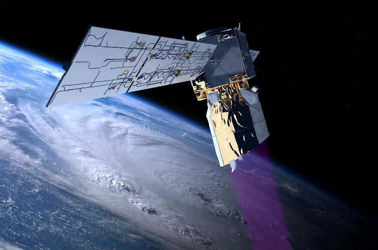
Over the last four years, ESA’s Aeolus mission has been delivering unique profiles of Earth’s winds from space, improving operational weather forecasts, climate models and more – all showing that its novel laser technology is advancing science and being used for important practical applications. Adding to the list of Aeolus’ successes, a recent report highlights that the mission has also brought economics benefits to Europe to the tune of €3.5 billion, and that a follow-on mission could more than double this figure.
Clive Billiald – New CEO for buildingSMART International
18.11.2022 11:48 buildingSMART.orgLondon, (November 18, 2022) – buildingSMART International is pleased to announce the appointment of Clive Billiald as its Chief Executive Officer, effective January 3, 2023. Clive has a track record…
The post Clive Billiald – New CEO for buildingSMART International appeared first on buildingSMART International.
Navigating the sea from space with innovative technologies
18.11.2022 11:45 ESA Navigation
Shipping is the most energy efficient form of transport, and more than 80% of goods traded globally are carried via the oceans, with a doubling in volume during the last quarter of a century. Recognising the global need for seamless maritime navigation, ESA’s Navigation Innovation and Support Programme, NAVISP – inventing the future of navigation with more than 200 R&D projects initiated to date – is therefore focused not only on the land but also the sea.
Update Revitu 2023.1 přináší nové funkce a Twinmotion
18.11.2022 10:38 Arkance SystemsNovinky a vylepšení v BIM aplikaci Autodesk Revit včetně napojení vizualizačního nástroje Twinmotion. Vizuální výstupy snadno a rychle.
Zpráva Update Revitu 2023.1 přináší nové funkce a Twinmotion pochází z arkance-systems.cz.
Nová aktualizace Revitu 2023.1 přináší nové funkce a Twinmotion
18.11.2022 10:38 Arkance SystemsNovinky a vylepšení v BIM aplikaci Autodesk Revit včetně napojení vizualizačního nástroje Twinmotion. Vizuální výstupy snadno a rychle.
Zpráva Nová aktualizace Revitu 2023.1 přináší nové funkce a Twinmotion pochází z arkance-systems.cz.
Earth from Space: Sharm El-Sheikh, Egypt
18.11.2022 10:00 ESA Observing the Earth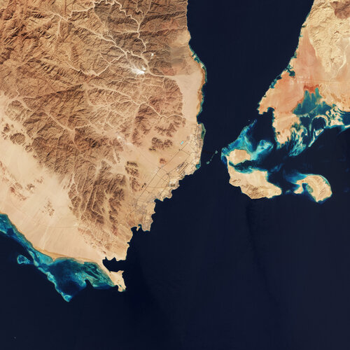
World leaders, policymakers and delegates from nearly 200 countries have convened in Sharm El-Sheikh over the past two weeks at the COP27 UN Climate Summit. Today we take a closer look at the Egyptian city through the eyes of Copernicus Sentinel-2.
Bentley Systems Declares Fourth Quarter 2022 Dividend
17.11.2022 22:03 Bentley SystemsBentley Systems, Incorporated (Nasdaq: BSY), the infrastructure engineering software company, today announced that its Board of Directors declared a $0.03 per share dividend for the fourth quarter of 2022. The cash dividend is payable on December 8, 2022 to all stockholders of record of Class A and Class B common stock as of the close of business on November 30, 2022.
The post Bentley Systems Declares Fourth Quarter 2022 Dividend appeared first on Bentley Systems | Infrastructure Engineering Software Company.Bentley Systems Declares Fourth Quarter 2022 Dividend
17.11.2022 22:03 Bentley SystemsBentley Systems, Incorporated (Nasdaq: BSY), the infrastructure engineering software company, today announced that its Board of Directors declared a $0.03 per share dividend for the fourth quarter of 2022. The cash dividend is payable on December 8, 2022 to all stockholders of record of Class A and Class B common stock as of the close of business on November 30, 2022.
The post Bentley Systems Declares Fourth Quarter 2022 Dividend appeared first on Bentley Systems | Infrastructure Engineering Software Company.Strengthening InCubed’s role in commercial Earth observation
17.11.2022 15:00 ESA Observing the Earth
Commercialisation is universally recognised as essential for the future prosperity of all aspects of the European space sector, and Earth observation is no exception. The ESA InCubed programme, a co-funding initiative that helps entrepreneurs bring their innovative ideas to market, has enjoyed enormous success since the launch of its first activity in 2018 and continues to make a prodigious contribution to commercial Earth observation. The InCubed portfolio includes around 60 activities, with an impressive €63 million invested so far.
At the upcoming ESA Council at Ministerial Level, Member States will have the possibility to further empower InCubed in its far-reaching efforts to foster commercial innovation. The programme proposal makes the case for a wider remit, including a set of new ‘Invest Actions’ designed to help boost the European Earth observation economy and reinforce relationships with the private investor community.
RoadShow 2022 – shrnutí
17.11.2022 13:48 3gon RoadShow 2022 – Shrnutí. ✔ V pátek 11.11.2022 jsme s naší firmou pro Vás uspořádali ukázku technologií od hardware (SOKKIA,Bentley Systems Announces Winners of the 2022 Going Digital Awards in Infrastructure
16.11.2022 20:37 Bentley SystemsNovember 16, 2022 | Press Announcement Read More
The post Bentley Systems Announces Winners of the 2022 Going Digital Awards in Infrastructure appeared first on Bentley Systems | Infrastructure Engineering Software Company.Bentley Systems Announces Winners of the 2022 Going Digital Awards in Infrastructure
16.11.2022 20:37 Bentley SystemsNovember 16, 2022 | Press Announcement Read More
The post Bentley Systems Announces Winners of the 2022 Going Digital Awards in Infrastructure appeared first on Bentley Systems | Infrastructure Engineering Software Company.Nový modul Rezervace parkovacích míst v Luhačovicích pomáhá hostům i městu
16.11.2022 15:30 T-MAPYThe post Nový modul Rezervace parkovacích míst v Luhačovicích pomáhá hostům i městu appeared first on T-MAPY spol. s r.o..
Nový modul Rezervace parkovacích míst v Luhačovicích pomáhá hostům i městu
16.11.2022 15:30 T-MAPYThe post Nový modul Rezervace parkovacích míst v Luhačovicích pomáhá hostům i městu appeared first on T-MAPY spol. s r.o..
18.11.2022 bude KATASTRÁLNÍ PRACOVIŠTĚ SEMILY UZAVŘENO
16.11.2022 14:41 ČÚZK - předpisy a opatření Katastrální úřad pro Liberecký kraj - Katastrální pracoviště Semily zveřejnil novou aktualitu: Katastrální pracoviště Semilyoznamuje, že z důvodu plánovaného přerušení dodávky elektrické energie
bude dne 18.11.2022 KATASTRÁLNÍ PRACOVIŠTĚ SEMILY UZAVŘENO.
Katastrálnímu pracovišti bude možno doručit podání prostřednictvím sběrného boxu (schránka venku vlevo od vchodových dveří pracoviště).
Schránka bude vybrána dne 21.11.2022 v ranních hodinách.
Podání je třeba do schránky vhodit v obálce. Úhradu správního poplatku lze provést buď formou vylepení kolkových známek na návrhu na vklad, případně lze vyčkat na sdělení platebních údajů pro bezhotovostní převod; úhradu nelze provést vhozením peněz v hotovosti do schránky.
Pro informaci o zaevidování podání ze sběrného boxu je třeba na podání uvést e-mailovou adresu, na kterou bude zasláno potvrzení o přijetí podání.
V Semilech dne 16.11.2022
Ing. Jiří Bekr, ředitel pracoviště
18.11.2022 bude KATASTRÁLNÍ PRACOVIŠTĚ SEMILY UZAVŘENO
16.11.2022 14:41 ČÚZK /Urady/Katastralni-urady/Katastralni-urady/Katastralni-urad-pro-Liberecky-kraj/Katastralni-pracoviste/KP-Semily/O-uradu/Aktuality/18-11-2022-je-KATASTRALNI-PRACOVISTE-SEMILY-UZAVREKrátka správa č. 51/2022
16.11.2022 14:08 Komora geodetů a kartografů SRThe post Krátka správa č. 51/2022 appeared first on Komora geodetov a kartografov.
vrchní referent/rada – vedení katastrální mapy
16.11.2022 13:52 ČÚZK - předpisy a opatření Katastrální úřad pro Olomoucký kraj Katastrální pracoviště Šumperkvypisuje výběrové řízení na místo
vrchní referent/rada – vedení katastrální mapy
vrchní referent/rada – vedení katastrální mapy
16.11.2022 13:52 ČÚZK - volná místa Katastrální úřad pro Olomoucký kraj Katastrální pracoviště Šumperk vypisuje výběrové řízení na místo vrchní referent/rada – vedení katastrální mapyvrchní referent/rada – vedení katastrální mapy
16.11.2022 13:52 ČÚZK /Urady/Katastralni-urady/Katastralni-urady/Katastralni-urad-pro-Olomoucky-kraj/Uredni-deska/Oznameni-a-jina-uredni-sdeleni/Volna-mista/DMS/vrchni-referent-rada-–-vedeni-katastralni-mapyvrchní referent/rada – návrh zápisu v katastru
16.11.2022 13:47 ČÚZK /Urady/Katastralni-urady/Katastralni-urady/Katastralni-urad-pro-Olomoucky-kraj/Uredni-deska/Oznameni-a-jina-uredni-sdeleni/Volna-mista/DMS/vrchni-referent-rada-–-navrh-zapisu-v-katastruvrchní referent/rada – návrh zápisu v katastru
16.11.2022 13:47 ČÚZK - předpisy a opatření Katastrální úřad pro Olomoucký kraj Katastrální pracoviště Šumperkvypisuje výběrové řízení na místo
vrchní referent/rada – návrh zápisu v katastru