


![]()

zprávy
zdroje zpráv:Spationomy 2.0 – pozvánka na konferenci
22.9.2022 10:55 GISportal.cz
Zástupci projektu Spationomy 2.0 – Spatial exploration of economic data, zvou na závěrečnou konferenci jejich Erasmus+ projektu, jehož cílem je inovovat způsob výuky o oborech ekonomie, obchodu, geoinformatiky geografie, a studia her (game studies), prostřednictvím moderních metod neformálního vyučování (gamifikace a hravé vzdělávání) a virtuálních technik telekolaborace. Projekt se zabývá otázkou učení se prostřednictvím hraní seriózní a […]
The post Spationomy 2.0 – pozvánka na konferenci appeared first on GISportal.cz.
20220926 - volné místo - Vrchní referent/rada v OAaD KP Ústí n.L.na Katastrálním úřadu pro Úst.kraj
22.9.2022 9:50 ČÚZK /Urady/Katastralni-urady/Katastralni-urady/Katastralni-urad-pro-Ustecky-kraj/Katastralni-pracoviste/KP-Usti-nad-Labem/O-uradu/Aktuality/20220926-volne-misto-Vrchni-referent-rada-v-OA20220926 - volné místo - Vrchní referent/rada v OAaD KP Ústí n.L.na Katastrálním úřadu pro Úst.kraj
22.9.2022 9:50 ČÚZK - předpisy a opatření Katastrální úřad pro Ústecký kraj - Katastrální pracoviště Ústí nad Labem zveřejnil novou aktualitu: Nabídka volného místa - Vrchní referent / rada v oddělení aktualizace a dokumentace katastru nemovitostí Katastrálního pracoviště Ústí nad Labem na Katastrálním úřadu pro Ústecký kraj20220926 - volné místo - Vrchní referent/rada v OAaD KP Ústí n.L.na Katastrálním úřadu pro Úst.kraj
22.9.2022 9:50 ČÚZK /Urady/Katastralni-urady/Katastralni-urady/Katastralni-urad-pro-Ustecky-kraj/O-uradu/Aktuality/20220926-volne-misto-Vrchni-referent-rada-v-OA20220926 - volné místo - Vrchní referent/rada v OAaD KP Ústí n.L.na Katastrálním úřadu pro Úst.kraj
22.9.2022 9:50 ČÚZK - předpisy a opatření Katastrální úřad pro Ústecký kraj - Katastrální pracoviště Ústí nad Labem zveřejnil novou aktualitu: Nabídka volného místa - Vrchní referent / rada v oddělení aktualizace a dokumentace katastru nemovitostí Katastrálního pracoviště Ústí nad Labem na Katastrálním úřadu pro Ústecký krajVrchní referent / rada v oddělení aktualizace a dokumentace katastru nemovitostí Katastrálního praco
22.9.2022 9:45 ČÚZK - volná místa Katastrální úřad pro Ústecký kraj Katastrální pracoviště Ústí nad Labem vypisuje výběrové řízení na místo Vrchní referent / rada v oddělení aktualizace a dokumentace katastru nemovitostí Katastrálního pracoVrchní referent / rada v oddělení aktualizace a dokumentace katastru nemovitostí Katastrálního praco
22.9.2022 9:45 ČÚZK - předpisy a opatření Katastrální úřad pro Ústecký kraj Katastrální pracoviště Ústí nad Labemvypisuje výběrové řízení na místo
Vrchní referent / rada v oddělení aktualizace a dokumentace katastru nemovitostí Katastrálního pracoviště Ústí nad Labem na Katastrálním úřadu pro Ústecký kraj
Vrchní referent / rada v oddělení aktualizace a dokumentace katastru nemovitostí Katastrálního praco
22.9.2022 9:45 ČÚZK /Urady/Katastralni-urady/Katastralni-urady/Katastralni-urad-pro-Ustecky-kraj/Uredni-deska/Oznameni-a-jina-uredni-sdeleni/Volna-mista/DMS/Vrchni-referent-rada-v-oddeleni-aktualizace-a-do20220922_Odborný rada v oddělení právních vztahů k nemovitostem
22.9.2022 9:17 ČÚZK /Urady/Katastralni-urady/Katastralni-urady/Katastralni-urad-pro-Stredocesky-kraj/Katastralni-pracoviste/KP-Rakovnik/O-uradu/Aktuality/20210922_Odborny-referent-oddeleni-aktualizace-(7)20220922_Odborný rada v oddělení právních vztahů k nemovitostem
22.9.2022 9:17 ČÚZK - předpisy a opatření Katastrální úřad pro Středočeský kraj - Katastrální pracoviště Rakovník Vyhlášení výběrového řízení: Odborný rada v oddělení právních vztahů k nemovitostem V části "Úřední deska", v sekci "Oznámení a jiná úřední sdělení" bylo vystaveno "Oznámení o vyhlášení výběrového řízení na obsazení služebního místa Odborný rada v oddělení právních vztahů k nemovitostem"ITT: EGNSS Additional Dissemination means
22.9.2022 9:17 European GNSS Agency could be provided via additional dissemination means")
Galileo is the European global satellite navigation system, under civil control, which provides satellite positioning and timing services worldwide. The European Commission is currently specifying the long-term evolution of the European Global Navigation Satellite System (EGNSS) Programme, including new services for Galileo and European Geostationary Navigation Overlay Service (EGNOS). Amongst these new services, Galileo High Accuracy Service (HAS) will provide real-time high accuracy improved user positioning (positioning error below two decimetres in nominal conditions according to the Galileo HAS Info Note) free of charge through the Galileo signal (E6-B) and via the Internet. With regards to EGNOS, the next generation will augment Galileo and Global Positioning System (GPS) in the L1 and L5 frequency bands and will extend the service area to the entire landmasses of EU member states. The dissemination over Medium Earth Orbit (MEO) and Geostationary Earth Orbit (GEO) satellites limits operational availability of the signal for end-users in high-latitudes. The contractor shall analyse cost-effective potential data delivery means alternative to the current EGNOS and Galileo ones.
A webinar to explain the framework and objectives of the procurement and its different tasks will be held on 4 October 2022 at 16:30 CEST. Please register for the webinar.
More information about the Invitation to Tender (ITT) and the contract notice publication can be found here.
Tailored premiums
Users are at the heart of the EU Space Programme. The annual User Consultation Platform is a chance for this group to share their needs and provide feedback.
Read more on this here: User Consultation Platform helps set the course for the EU Space Programme
The Galileo System became operational in December of 2016 with the provision of initial services for the Open Service, Search and Rescue Service and Public Regulated Service. In the Full Operational Capability (FOC) phase the constellation will consist of 30 satellites, including in orbit spares, in Medium Earth Orbit. As part of its main services, Galileo shall broadcast authentication data through its Navigation Message Authentication (OS NMA), which provides information about the received signal’s authenticity and protects the users against certain attacks. Also, Galileo shall provide a High-Accuracy Service (HAS), through correction data disseminated via signal in space and terrestrial means
EGNOS currently provides augmentation to the GPS Standard Positioning Service (SPS). EGNOS augments GPS using the L1 (1,575.42 MHz) Coarse/Acquisition (C/A) civilian signal function by broadcasting correction data and integrity information for positioning and navigation applications over Europe. Around 2028, the next generation of EGNOS, EGNOS V3, will augment Galileo and GPS OS constellations in the L1 and L5 bands and will extend the service area across the EU. New EGNOS services could be implemented in further releases of EGNOS beyond 2028.
Media note: This feature can be republished without charge provided the European Union Agency for the Space Programme (EUSPA) is acknowledged as the source at the top or the bottom of the story. You must request permission before you use any of the photographs on the site. If you republish, we would be grateful if you could link back to the EUSPA website (http://www.euspa.europa.eu).
Odborný rada v oddělení právních vztahů k nemovitostem
22.9.2022 9:17 ČÚZK - předpisy a opatření Katastrální úřad pro Středočeský kraj - Katastrální pracoviště Rakovníkvypisuje výběrové řízení na místo
Odborný rada v oddělení právních vztahů k nemovitostem
Odborný rada v oddělení právních vztahů k nemovitostem
22.9.2022 9:17 ČÚZK - předpisy a opatření Katastrální úřad pro Středočeský kraj Katastrální pracoviště Rakovníkvypisuje výběrové řízení na místo
Odborný rada v oddělení právních vztahů k nemovitostem
Odborný rada v oddělení právních vztahů k nemovitostem
22.9.2022 9:17 ČÚZK /Urady/Katastralni-urady/Katastralni-urady/Katastralni-urad-pro-Stredocesky-kraj/Uredni-deska/Oznameni-a-jina-uredni-sdeleni/Volna-mista/DMS/Odborny-rada-v-oddeleni-pravnich-vztahu-k-nemovitoOdborný rada v oddělení právních vztahů k nemovitostem
22.9.2022 9:17 ČÚZK - volná místa Katastrální úřad pro Středočeský kraj Katastrální pracoviště Rakovník vypisuje výběrové řízení na místo Odborný rada v oddělení právních vztahů k nemovitostemOdborný rada v oddělení právních vztahů k nemovitostem
22.9.2022 9:17 ČÚZK - volná místa Katastrální úřad pro Středočeský kraj - Katastrální pracoviště Rakovník vypisuje výběrové řízení na místo Odborný rada v oddělení právních vztahů k nemovitostemSatLab Gained A Huge Attraction at FIG Congress 2022
22.9.2022 6:02 Satlab GeosolutionsVolunteering for the future - Geospatial excellence for a better living
The post SatLab Gained A Huge Attraction at FIG Congress 2022 appeared first on Global Satellite Positioning Solutions | SatLab Geosolutions AB.
SatLab Gained A Huge Attraction at FIG Congress 2022
22.9.2022 6:02 Satlab Geosolutions Volunteering for the future - Geospatial excellence for a better livingLaunch of Bentley Mini Documentary Films Produced by BBC Storyworks Part of Beneath the Surface Series
21.9.2022 18:23 Bentley SystemsBentley Systems, Incorporated (Nasdaq: BSY), the infrastructure engineering software company, wishes to recognize two of its users presenting their digital advancements in mini documentary films showcased at the International Water Association World Water Congress in Copenhagen, September 11–15.
The post Launch of Bentley Mini Documentary Films Produced by BBC Storyworks Part of Beneath the Surface Series appeared first on Bentley Systems | Infrastructure Engineering Software Company.20220921-Zkoušky ÚOZI
21.9.2022 12:19 ČÚZK - předpisy a opatření Český úřad zeměměřický a katastrální zveřejnil novou aktualitu: Zkoušky ÚOZI se budou konat dne 5. října 2022.20220921-Zkoušky ÚOZI
21.9.2022 12:19 ČÚZK - aktuality v resortu Zkoušky ÚOZI se budou konat dne 5. října 2022.20220921-Zkoušky ÚOZI
21.9.2022 12:19 ČÚZK - aktuality v resortu Zkoušky ÚOZI se budou konat dne 5. října 2022.A critical factor for success: BIM in electrical engineering
21.9.2022 12:03 buildingSMART.orgAndreas Matthé, CEO Electrical Products, Smart Infrastructure, Siemens AG, explains why electrical engineering has to master Building Information Modeling (BIM) to remain successful. To BIM or not to BIM? That…
The post A critical factor for success: BIM in electrical engineering appeared first on buildingSMART International.
Proběhla konference CADfórum 2022 – děkujeme za účast
21.9.2022 11:57 Arkance Systems19. ročník tradiční podzimní konference CADfórum 2022 proběhl v Olomouci, kam se sjelo na 400 zájemců z celého Česka a Slovenska.
Zpráva Proběhla konference CADfórum 2022 – děkujeme za účast pochází z arkance-systems.cz.
Galileo-enabled receivers installed in Prague tramways
21.9.2022 11:16 European GNSS Agency
Multi-frequency satellite receivers using Galileo amongst other satellite navigation systems are helping to refine the position of Prague trams, ensuring high accuracy even in the dense development of the centre of Prague, showing deviations of no more than 2.5 metres. The Prague Public Transport Company (DPP) is gradually installing new receivers in all trams. It should be completed by the end of next year.
The precise localisation of trams will improve the overview of the current traffic situation for dispatchers and passengers. It will also open up opportunities for further savings in vehicle and infrastructure operations such as optimising the journey.
"Thanks to the cooperation with scientists and experts from the Faculty of Electrical Engineering of the Czech Technical University, the European Union Agency for the Space Programme and the Ministry of Transport, we have a solution for determining the exact location of Prague trams. As part of the pilot project, we have tested different types of multi-frequency receivers with DPP, with each of them we have completed dozens of tests run in normal operation. We managed to find the most suitable type of satellite receiver and determine its configuration. During the test runs, it showed only minimal position deviations, up to a maximum of 2 metres," said Adam Scheinherr, Deputy Mayor of the Capital City of Prague and chairman of the Supervisory Board of DPP.
"We have been using outdated satellite receivers in trams to determine the exact position of the vehicles for about 20 years, they work only on the GPS system. However, in the dense development in the centre of Prague, these devices very often showed and still show significant deviations from the actual position of tens to hundreds of metres. Therefore, in 2019, in cooperation with the City of Prague, experts from the Faculty of Electrical Engineering of the Czech Technical University and EUSPA, we launched a pilot project with the aim not only to modernize the existing receivers, but also to find a type and configuration that would withstand the operation of trams in the specific conditions of the Prague city centre," said Milan Slunečko, head of the Tram Vehicle Management Unit of the DPP. Currently one third of the DPP fleet is equipped.
"The European Union Agency for the Space Programme has long supported the deployment of the Galileo and EGNOS satellite navigation systems in transport. In addition to their common use by passengers in various transport applications on mobile phones, our navigation services are used, for example, for the instrumented approach of aircraft on landing or for precise vehicle location in traffic accidents in the eCall system, where they can help ensure the timely arrival of the integrated rescue system. We are pleased that Galileo will also help to improve localization in Prague tram transport and open up space for further innovation and streamlining of daily operations," concluded Daniel Lopour from EUSPA.
Other cities in Europe such as Madrid are also using GNSS-based intelligent transport solutions to improve the user experience for their public transport.
Galileo is enabling intelligent transport solutions and thus supporting cities in their efforts to become smarter and more sustainable. It is another contribution to the EU priority for a greener and more digital Europe.
Media note: This feature can be republished without charge provided the European Union Agency for the Space Programme (EUSPA) is acknowledged as the source at the top or the bottom of the story. You must request permission before you use any of the photographs on the site. If you republish, we would be grateful if you could link back to the EUSPA website (http://www.euspa.europa.eu).
Sekce Urban Air Mobility na evropské akci Urban Mobility Days 2022 v Brně
21.9.2022 10:39 UAVAPřijměte pozvání na poslední chvíli na zítřejší sekci Urban Air Mobility, která se koná v Brně od 9:30 – 10:50 v rámci třídenní akce Urban Mobility Days 2022 od Evropské Komise v rámci českého předsednictví v Radě EU. Program a více informací o akci, kde je registrace ZDARMA zde: https://www.eumd.org/en/me/programme/
The post Sekce Urban Air Mobility na evropské akci Urban Mobility Days 2022 v Brně appeared first on UAV Aliance pro bezpilotní letecký průmysl.
20220905_Rada / odborný rada v oddělení právních vztahů k nemovitostem
21.9.2022 10:35 ČÚZK - předpisy a opatření Katastrální úřad pro Středočeský kraj - Katastrální pracoviště Rakovník Vyhlášení výběrového řízení: Rada / odborný rada v oddělení právních vztahů k nemovitostem V části "Úřední deska", v sekci "Oznámení a jiná úřední sdělení" bylo vystaveno "Oznámení o vyhlášení výběrového řízení na obsazení služebního místa Rada / odborný rada v oddělení právních vztahů k nemovitostem"20220905_Rada / odborný rada v oddělení právních vztahů k nemovitostem
21.9.2022 10:35 ČÚZK /Urady/Katastralni-urady/Katastralni-urady/Katastralni-urad-pro-Stredocesky-kraj/Katastralni-pracoviste/KP-Rakovnik/O-uradu/Aktuality/20210922_Odborny-referent-oddeleni-aktualizace-(6)rada/odborný rada v oddělení právních vztahů k nemovitostem
21.9.2022 10:33 ČÚZK - volná místa Katastrální úřad pro Středočeský kraj - Katastrální pracoviště Rakovník vypisuje výběrové řízení na místo rada/odborný rada v oddělení právních vztahů k nemovitostemrada/odborný rada v oddělení právních vztahů k nemovitostem
21.9.2022 10:33 ČÚZK - předpisy a opatření Katastrální úřad pro Středočeský kraj Katastrální pracoviště Rakovníkvypisuje výběrové řízení na místo
rada/odborný rada v oddělení právních vztahů k nemovitostem
rada/odborný rada v oddělení právních vztahů k nemovitostem
21.9.2022 10:33 ČÚZK - volná místa Katastrální úřad pro Středočeský kraj Katastrální pracoviště Rakovník vypisuje výběrové řízení na místo rada/odborný rada v oddělení právních vztahů k nemovitostemrada/odborný rada v oddělení právních vztahů k nemovitostem
21.9.2022 10:33 ČÚZK - předpisy a opatření Katastrální úřad pro Středočeský kraj - Katastrální pracoviště Rakovníkvypisuje výběrové řízení na místo
rada/odborný rada v oddělení právních vztahů k nemovitostem
Zooming in on drought from space
21.9.2022 10:20 ESA Observing the Earth
We are all aware that the summer of 2022 has been one of the hottest on record, causing drought and raging wildfires in many parts of Europe. Satellite data have been used to report the baking temperatures of the land surface and map fires, but the Copernicus Sentinel-1 radar mission has also been used to zoom in and provide very high-resolution measurements of the actual moisture content of the surface soils. Maps of northern Italy, for example, show how dry this summer has been compared to two years ago.
Změna výpůjční doby [Knihovna geografie, byTopic]
21.9.2022 9:00 Katedra aplikované geoinformatiky a kartografie Přf UK Z důvodů nemoci bude ve středu 21. 9. otevřeno do 14,00.Ve čtvrtek (22. 9.) a v pátek (23. 9.) do 12,00. Děkujeme za pochopení.
Prosíme, buďte ohleduplní a pokud jste nachlazení, nechoďte do knihovny.
Změna výpůjční doby [Knihovna geografie, byTopic]
21.9.2022 9:00 Katedra aplikované geoinformatiky a kartografie Přf UK Z důvodů nemoci bude v pondělí 26. 9. otevřeno do 15,00. Děkujeme za pochopení.Prosíme, buďte ohleduplní a pokud jste nachlazení, nechoďte do knihovny.
Odborný referent v oddělení aktualizace KN č.1 na Katastrálním pracovišti Znojmo
21.9.2022 8:07 ČÚZK - volná místa Katastrální úřad pro Jihomoravský kraj Katastrální pracoviště Znojmo vypisuje výběrové řízení na místo Odborný referent v oddělení aktualizace KN č.1 na Katastrálním pracovišti ZnojmoOdborný referent v oddělení aktualizace KN č.1 na Katastrálním pracovišti Znojmo
21.9.2022 8:07 ČÚZK /Urady/Katastralni-urady/Katastralni-urady/Katastralni-urad-pro-Jihomoravsky-kraj/Volna-mista/DMS/Odborny-referent-v-oddeleni-aktualizace-KN-c-1-naOdborný referent v oddělení aktualizace KN č.1 na Katastrálním pracovišti Znojmo
21.9.2022 8:07 ČÚZK - předpisy a opatření Katastrální úřad pro Jihomoravský kraj Katastrální pracoviště Znojmovypisuje výběrové řízení na místo
Odborný referent v oddělení aktualizace KN č.1 na Katastrálním pracovišti Znojmo
An activity report to develop a potential soltion to IFC for Products has been endorsed by the Product Room SC. Please click the link to read more.
20.9.2022 20:01 buildingSMART.orgGo to document
The post An activity report to develop a potential soltion to IFC for Products has been endorsed by the Product Room SC. Please click the link to read more. appeared first on buildingSMART International.
The BIM-BEM Workflows report has been issued to the standards committee prior to publication as a technical report. Please click the link to review the document.
20.9.2022 20:00 buildingSMART.orgGo to document
The post The BIM-BEM Workflows report has been issued to the standards committee prior to publication as a technical report. Please click the link to review the document. appeared first on buildingSMART International.
Aktualizace údajů
20.9.2022 14:15 Ústecký kraj V Geoportálu ÚAP Ústeckého kraje byla provedena aktualizace údajů pro poskytovatele Agentura ochrany přírody a krajiny České republiky – jev 25a, 27a, 32 a Ministerstvo obrany – jev 44, 68, 70, 73, 75, 79, 80, 82a, 93a, 94a, 102a, 107, 108.
Technická odstávka ESKN a ZBGIS
20.9.2022 13:40
ÚGKK SR
Vážení spoluobčania,
Úrad geodézie, kartografie a katastra SR (ÚGKK SR) sa snaží vylepšiť svoje služby pre Vás a z toho dôvodu je potrebné kvôli ešte lepšej funkčnosti portálov ESKN a ZBGIS urobiť TECHNICKÚ ODSTÁVKU.
ÚGKK SR oznamuje, že technická odstávka elektronických služieb ÚGKK SR bude v čase od piatka 23.09.2022 od 18:00 do pondelka 26.09.2022 do 12:00, ktorá skvalitní naše elektronické služby pri plánovanej technickej aktualizácii informačných systémov.
Ospravedlňujeme sa za dočasnú nedostupnosť elektronických služieb predovšetkým Portálu ESKN a ZBGIS. #PortálESKN #od:23.09.2022@18:00 #do: 26.09.2022@12:00
Invent tomorrow’s driving with NAVISP
20.9.2022 12:11 ESA Navigation
The way we drive is evolving rapidly, trending towards progressively more automated vehicles and smarter road infrastructure. ESA’s NAVISP programme, in cooperation with new partner ERTICO-ITS, the organisation for intelligent transport systems in Europe, invites ideas from European industry, institutions and research institutes to support this trend through the provision of ‘positioning, navigation and timing’ (PNT) information to let vehicles know exactly where and when they are as they drive.
Konference GIS Esri v ČR – představení řečníků
20.9.2022 11:21 GISportal.cz
Termín Konference GIS Esri v ČR se pomalu blíží, a my Vám proto přinášíme první informace o jejím programu. Hlavní řečníci V úvodním bloku přednášek letos vystoupí následující řečníci: RNDr. Václav Cílek, CSc.; geolog a esejista pracující v Geologickém ústavu AV ČR a v Centru pro teoretická studia, člen třetí „Pačesovy“ energetické komise. Ing. Dana Drábová, Ph.D.; […]
The post Konference GIS Esri v ČR – představení řečníků appeared first on GISportal.cz.
Konference GIS Esri v ČR – představení řečníků
20.9.2022 11:21 GISportal.czTermín Konference GIS Esri v ČR se pomalu blíží, a my Vám proto přinášíme první informace o jejím programu. Hlavní řečníci V úvodním bloku přednášek letos vystoupí následující řečníci: RNDr. Václav Cílek, CSc.; geolog a esejista pracující v Geologickém ústavu AV ČR a v Centru pro teoretická studia, člen třetí „Pačesovy“ energetické komise. Ing. Dana Drábová, Ph.D.; […]
The post Konference GIS Esri v ČR – představení řečníků appeared first on GISportal.cz.
Oznámení - otevírací doba 20.9.2022 [Knihovna geografie, byTopic]
20.9.2022 8:20 Katedra aplikované geoinformatiky a kartografie Přf UK Z provozních důvodů má knihovna geografie dnes otevřeno pouze do 16:00.Výstava “České země uprostřed Evropy” [Knihovna geografie, byTopic]
20.9.2022 0:00 Katedra aplikované geoinformatiky a kartografie Přf UK Národní archiv zahájil minulý týden výstavu zaměřenou na témata a historické souvztažnosti mezi českými zeměmi a dalšími regiony Evropy v období aktuálního předsednictví České republiky v Radě EU, která se koná ve výstavním sále v archivním areálu v Praze na Chodovci. Kontakty českých zemí s evropskými zeměmi, hospodářské i kulturní, dokumentují kromě jiných archiválií početné mapy a plány období 17.–19. století uložené v Národním archivu.Bentley Systems Announces the Finalists in the 2022 Going Digital Awards in Infrastructure
19.9.2022 21:43 Bentley SystemsBentley Systems, Incorporated (Nasdaq: BSY), the
infrastructure engineering software company, today announced the finalists in the 2022 Going
Digital Awards in Infrastructure.
Podrobný popis služeb IS DMVS
19.9.2022 17:43 ČÚZK - předpisy a opatření Do záložky Popis služeb byl přidán Podrobný popis služeb IS DMVS, který poskytuje budoucím uživatelům IS DMVS jednoduchý a srozumitelný popis základních principů chování jednotlivých služeb a celého rozhraní. Součástí jsou popisy společných prvků pro jednotlivé služby a popis posloupnosti volání jednotlivých služeb pro činnosti prováděné v IS DMVS. Samotné služby jsou popsány ve vlastních dokumentech.Analytik pro regionální rozvoj – nová pracovní pozice na Regionální rozvojové agentuře Plzeňského kraje
19.9.2022 12:37 Blogující geomatici - FAV ZČUVíce informací najdete na: https://www.linkedin.com/jobs/view/3230834179/?refId=1hDCdy5DRU%2BNnbcMZZd6Tg%3D%3D
Analytik pro regionální rozvoj – nová pracovní pozice na Regionální rozvojové agentuře Plzeňského kraje
19.9.2022 12:37 Blogující geomatici - FAV ZČURegionální rozvojové agentuře Plzeňského kraje organizace buduje více než 20 let znalostní systém týkající se rozvoje Plzeňského kraje.
Věnujeme se demografickým analýzám a projekcím, hodnotíme vývoj pracovního trhu, vzdělávání, výzkumu, vývoje a inovací, zpracováváme podklady pro územní studie a připravujeme regionální i oborově zaměřené rozvojové koncepce a strategie.
Data zpracováváme s využitím Power BI a geografických informačních systémů.
Našimi zákazníky jsou především obce a regionální správa Plzeňského kraje. Některé výsledky naší práce najdete na našem webu na www.rra-pk.cz
Rádi bychom v našem týmu přivítali nového pracovníka, který bude členem analytického týmu a jehož úkolem bude především:
- zajišťovat průběžný sběr veřejně dostupných dat pro monitoring vývoje kraje (zejm. demografie, zaměstnanost, vzdělávání, výzkum, vývoj a inovace) a aktualizovat aplikace pro hodnocení a prezentaci změn (například na portálu www.studujvpk.cz);
- spolupracovat na přípravě územních, či oborových analýz, koncepcí a strategií;
- zapojit se do pracovních skupin projektů (například platforma Pakt zaměstnanosti Plzeňského kraje - www.pzpk.cz, nebo projekt Smart Akcelerátor Plzeňského kraje - www.inovujtevpk.cz)
- připravovat digitální dotazníkové průzkumy a zajišťovat jejich vyhodnocování;
- příležitostně poskytovat datovou podporu při přípravě a hodnocení rozvojových projektů.
Požadavky:
- ukončené magisterské, případně bakalářské vzdělání v oborech zaměřených na demografii nebo geografii, případně oborů s výraznějším podílem matematiky, statistiky a geoinformatiky;
- schopnost využívání analytických nástrojů MS Excel, případně dovednost využívání některého z SW nástrojů pro statistickou analýzu;
- alespoň základní znalost využití geografických informačních systémů (ideálně produkty ESRI).
U uchazečů dále oceníme:
- předchozí zkušenosti v oboru;
- všeobecný přehled v oblastech regionálního rozvoje a územní veřejné správy;
- zájem o získávání nových poznatků a dovedností v oblasti analýzy dat v kontextu regionálního rozvoje.
Nabízíme:
- příležitost zapojit se do projektů s dopadem na kvalitu života v Plzeňském kraji;
- možnost zapojit se do týmu zkušených analytiků a získat nové dovednosti;
- příjemné pracovní prostředí v centru Plzně a možnost dohody o částečném zajištění práce z domova;
- odpovídající platové hodnocení;
- podporu při zvyšování kvalifikace;
- po zkušební době pracovní poměr na dobu neurčitou.
Možnost nástupu kdykoli během 09-11/2022.
V případě zájmu prosíme zašlete životopis a stručné odůvodnění Vašeho zájmu o uvedenou pracovní pozici na adresu: uhlik@rra-pk.cz.
Vhodné uchazeče oslovíme a nabídneme jim termín osobního jednání.
Více informací najdete na: https://www.linkedin.com/jobs/view/3230834179/?refId=1hDCdy5DRU%2BNnbcMZZd6Tg%3D%3D
Příležitost pro práci v oboru Geograf
19.9.2022 11:41 Blogující geomatici - FAV ZČU OZNÁMENÍ O VYHLÁŠENÍ VÝBĚROVÉHO ŘÍZENÍ NA OBSAZENÍ SLUŽEBNÍHO MÍSTAGeograf/ka
kód správní činnosti 2.62.10,
Č. j.: ZÚ-04330/2022-12010
Datum: 16. září 2022
Ing. Karel Brázdil, CSc, ředitel Zeměměřického úřadu jako služební orgán příslušný podle § 10 odst. 1 písm. f) zákona č. 234/2014 Sb., o státní službě, ve znění pozdějších předpisů (dále jen „zákon“), vyhlašuje výběrové řízení na služební místo Geograf/ka v oboru služby „Zeměměřictví a katastr nemovitostí.“
Místem výkonu služby je Plzeň.
Služební místo je zařazeno podle Přílohy č. 1 k zákonu do 10. platové třídy, EX ID služebního místa 90000343.
- Aktualizace Základní databáze geografických dat ČR (ZABAGED®), především vyhodnocení zpracovaných dat z hlediska kvality a geometrické topologie s využitím používaných technologických nástrojů. Zajištění uživatelské podpory zaměstnanců oddělení při práci v těchto technologiích.
- Provádění odborných systémových činností souvisejících se správou a aktualizací Základní báze geografických dat ČR (ZABAGED®). Především:
- zpracování podkladových datových souborů a tiskových výstupů pro aktualizaci dat ZABAGED®
- vyhodnocování zpracovaných dat z hlediska kvality a geometrické topologie
- uživatelská podpora pracovníků oddělení; úprava nastavení a parametrizací uživatelského prostředí včetně zajištění aktualizace systémů pro aktualizaci polohopisné i výškopisné složky ZABAGED®
- Spolupráce při instalaci a testování aplikačního programového vybavení.
- Orientace v HW a SW vybavení pracoviště, základní identifikace a řešení chyb a poruch.
- 5 týdnů dovolené,
- 5 dnů indispozičního volna,
- FKSP (penzijní připojištění, životní pojištění aj.),
- stravování v závodní jídelně s příspěvkem organizace z FKSP,
- možnost ubytování v zařízení úřadu,
- pružná pracovní doba,
- možnost osobního rozvoje v zájmu organizace,
- práce v příjemném kolektivu.
Více informací naleznete na https://www.cuzk.cz/getattachment/d681a651-e841-4630-88d6-423dd271b2a2/Geograf-ka-(1).aspx
Představujeme první části programu Konference GIS Esri v ČR 2022
19.9.2022 11:07 ARCDATADo zahájení Konference GIS Esri v ČR 2022 zbývá už jen 6 týdnů a my Vám nyní přinášíme první informace o jejím programu. Pojďme si nejdříve představit osobnosti, na které se můžete těšit.
Úvodní blok a hlavní řečníci
RNDr. Václav Cílek, CSc.; geolog a esejista pracující v Geologickém ústavu AV ČR a v Centru pro teoretická studia, člen třetí „Pačesovy“ energetické komise.
Ing. Dana Drábová, Ph.D.; vědkyně, jaderná inženýrka a předsedkyně Státního úřadu pro jadernou bezpečnost.
- RNDr. Radim Tolasz, Ph.D.; přední český klimatolog, člen Světové meteorologické organizace a Mezivládního panelu pro změnu klimatu.
Speciální hosté:
- Mgr. Ondřej Boháč: ředitel Institutu plánování a rozvoje hlavního města Prahy od prosince 2016.
- Mgr. Jiří Čtyroký, Ph.D.: ředitel sekce prostorových informací Institutu plánování a rozvoje hl. m. Prahy.
Stálice programu
Již samozřejmou součástí programu zůstávají bloky věnující se aktuálním otázkám veřejné správy a inženýrských sítí, stejně jako přednášky zaměřené na technologie či odborné workshopy.
Těšit se opět můžete i na nabitý doprovodný program.K dispozici Vám bude stánek technické podpory, tematické minisemináře nebo oblíbená přehlídka map a aplikací, kam až do 7. října můžete přihlásit i tu svou.
Jak se zúčastnit
K fyzické účasti na konferenci již zbývá jen několik posledních míst. Díky možnosti digitálního přístupu k obsahu konference Vám ale ani tak nemusí nic uniknout. Aktuální informace o možnostech přihlášení získáte na webových stránkách akce.
Představujeme první části programu Konference GIS Esri v ČR 2022
19.9.2022 11:07 ARCDATADo zahájení Konference GIS Esri v ČR 2022 zbývá už jen 6 týdnů a my Vám nyní přinášíme první informace o jejím programu. Pojďme si nejdříve představit osobnosti, na které se můžete těšit.
Úvodním blok a hlavní řečníci
RNDr. Václav Cílek, CSc.; geolog a esejista pracující v Geologickém ústavu AV ČR a v Centru pro teoretická studia, člen třetí „Pačesovy“ energetické komise.
Ing. Dana Drábová, Ph.D.; vědkyně, jaderná inženýrka a předsedkyně Státního úřadu pro jadernou bezpečnost.
- RNDr. Radim Tolasz, Ph.D.; přední český klimatolog, člen Světové meteorologické organizace a Mezivládního panelu pro změnu klimatu.
Speciální hosté:
- Mgr. Ondřej Boháč: ředitel Institutu plánování a rozvoje hlavního města Prahy od prosince 2016.
- Mgr. Jiří Čtyroký, Ph.D.: ředitel sekce prostorových informací Institutu plánování a rozvoje hl. m. Prahy.
Stálice programu
Již samozřejmou součástí programu zůstávají bloky věnující se aktuálním otázkám veřejné správy a inženýrských sítí, stejně jako přednášky zaměřené na technologie či odborné workshopy.
Těšit se opět můžete i na nabitý doprovodný program.K dispozici Vám bude stánek technické podpory, tematické minisemináře nebo oblíbená přehlídka map a aplikací, kam až do 7. října můžete přihlásit i tu svou.
Jak se zúčastnit
K fyzické účasti na konferenci již zbývá jen několik posledních míst. Díky možnosti digitálního přístupu k obsahu konference Vám ale ani tak nemusí nic uniknout. Aktuální informace o možnostech přihlášení získáte na webových stránkách akce.
Mapová aplikace ZÚR - nová podoba
19.9.2022 7:23 Jihočeský krajMapová aplikace Zásady územního rozvoje Jihočeského kraje nyní zobrazuje ZÚR JČK ve vektorové podobě na místo původních rastrových skenů.
Využijte rychlé promo akce v září – 15% sleva na vybrané produkty Autodesku
19.9.2022 0:00 Arkance SystemsZískejte oblíbené aplikace AutoCAD, AutoCAD LT a AutoCAD Revit LT Suite se slevou. Pouze do 22. září 2022.
Zpráva Využijte rychlé promo akce v září – 15% sleva na vybrané produkty Autodesku pochází z arkance-systems.cz.
Využijte rychlé promo akce v září – 15% sleva na vybrané produkty Autodesku
19.9.2022 0:00 Arkance SystemsZískejte oblíbené aplikace AutoCAD, AutoCAD LT a AutoCAD Revit LT Suite se slevou. Akce trvá pouze do 22.9. 2022.
Zpráva Využijte rychlé promo akce v září – 15% sleva na vybrané produkty Autodesku pochází z arkance-systems.cz.
300 let Müllerovy mapy Čech - repríza výstavy [Knihovna geografie, byTopic]
19.9.2022 0:00 Katedra aplikované geoinformatiky a kartografie Přf UK Repríza výstavy v Národním technickém muzeu v Praze (od 14.9.2022 do 30.4.2023) představuje Müllerovu mapu Čech, unikátní dílo hodnotné nejen svou uměleckou úrovní, ale také technickou vzácností.DAEX CUT Optimalizátor s propojením na formátovací pily
18.9.2022 20:26 ŠPINAR - softwareDAEX CUT Optimalizátor Pro s DAEX Pila pro truhlářské a nábytkářské firmy Vám umožní spravovat zakázky, nabídky, objednávky, spotřebou materiálu a optimalizací nářezových plánů se zobrazením řezu přímo na tabletu na formátovací pile.
The post DAEX CUT Optimalizátor s propojením na formátovací pily appeared first on ŠPINAR – software.
DAEX CUT Optimalizátor s propojením na formátovací pily
18.9.2022 20:26 ŠPINAR - software DAEX CUT Optimalizátor Pro s DAEX Pila pro truhlářské a nábytkářské firmy Vám umožní spravovat zakázky, nabídky, objednávky, spotřebou materiálu a optimalizací nářezových plánů se zobrazením řezu přímo na tabletu na formátovací pile.DAEX CUT Optimalizátor s propojením na běžné formátovací pily
18.9.2022 20:26 ŠPINAR - softwareDAEX CUT Optimalizátor Pro s DAEX Pila Vám pro truhlářské a nábytkářské firmy Vám umožní spravovat zakázky, nabídky, objednávky, spotřebou materiálu a optimalizací nářezových plánů se zobrazením řezu přímo na tabletu na formátovací pile.
The post DAEX CUT Optimalizátor s propojením na běžné formátovací pily appeared first on ŠPINAR – software.
Synspective’s Third SAR Satellite “StriX-1” Successfully Reaches Its Target Orbit
16.9.2022 20:40 GISCafe.com Webcasts-Webinars TOKYO, 2022, September 16 – Synspective Inc., a SAR satellite data and solutions provider, announced today that StriX-1, its third SAR …Supporting the increased bandwidth demands of light rail with new antenna range from HUBER+SUHNER
16.9.2022 20:39 GISCafe.com Webcasts-Webinars Dedicated antennas optimised for light rail vehicles have been launched by HUBER+SUHNER, further expanding its offering to the transport sector. …SOSLAB Launches Next-generation 3D Solid-state LiDAR, ML-X
16.9.2022 20:39 GISCafe.com Webcasts-Webinars SEOUL, South Korea — (BUSINESS WIRE) — September 16, 2022 —SOSLAB, a self-driving technology startup that has won recognition for …
Euroconsult 2022: BlackSky Receives Pioneer in Space Business Award
16.9.2022 20:39 GISCafe.com Webcasts-Webinars Company recognized for innovative, industry-changing end-to-end dynamic monitoring capabilitiesHERNDON, Va. — (BUSINESS WIRE) — …
How do satellites monitor the ozone layer?
16.9.2022 14:25 ESA Observing the Earth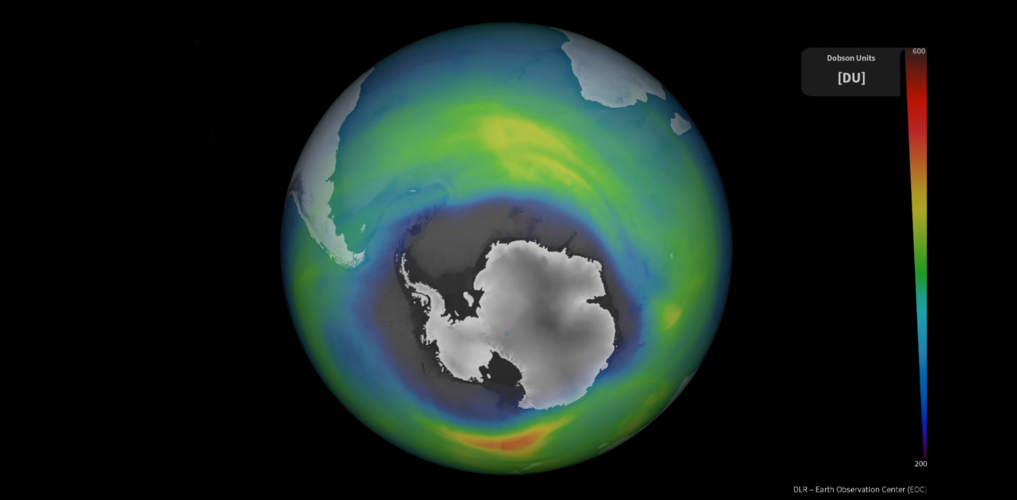
The ozone layer in our upper atmosphere protects Earth from the harmful effects of ultraviolet radiation. The use of human-produced chemicals in our atmosphere used for many years depleted Earth’s ozone layer. However, the reduction in the consumption of ozone-depleting substances driven by the Montreal Protocol – an international treaty designed to protect the ozone layer – has allowed for the ozone hole to slowly recover. This global agreement demonstrates the power of international commitment and immediate global action in protecting our environment.
ESA has been involved in monitoring the ozone for over two decades. Today, 16 September, marks the International Day for the Preservation of the Ozone Layer and we take a closer look at how satellite instruments carefully monitor the ozone layer over the South Pole.
Krátka správa č. 41/2022
16.9.2022 10:09 Komora geodetů a kartografů SRThe post Krátka správa č. 41/2022 appeared first on Komora geodetov a kartografov.
Earth from Space: UK heatwave
16.9.2022 10:00 ESA Observing the Earth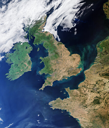
This summer, heatwaves struck Europe, North Africa, the US and Asia with temperatures reaching over 40°C in places – breaking many long-standing records. Images from the Copernicus Sentinel-3 mission show the scale of Britain’s heatwave as it baked in extreme temperatures in August.
výběrové řízení na KP Jihlava - aktualizace
16.9.2022 9:37 ČÚZK /Urady/Katastralni-urady/Katastralni-urady/Katastralni-urad-pro-Vysocinu/O-uradu/Aktuality/vyberove-rizeni-na-KP-Jihlava-aktualizacevýběrové řízení na KP Jihlava - aktualizace
16.9.2022 9:37 ČÚZK - předpisy a opatření Katastrální úřad pro Vysočinu - Katastrální pracoviště Jihlava zveřejnil novou aktualitu: Oznámení o vyhlášení výběrového řízení na služební místo odborný referent v oddělení aktualizace KN I Katastrálního pracoviště Jihlava.výběrové řízení na KP Jihlava - právní
16.9.2022 9:36 ČÚZK - předpisy a opatření Katastrální úřad pro Vysočinu - Katastrální pracoviště Jihlava zveřejnil novou aktualitu: Oznámení o vyhlášení výběrového řízení na služební místo odborný referent v oddělení právní vztahy k nemovitostem Katastrálního pracoviště Jihlava.výběrové řízení na KP Jihlava - právní
16.9.2022 9:36 ČÚZK /Urady/Katastralni-urady/Katastralni-urady/Katastralni-urad-pro-Vysocinu/O-uradu/Aktuality/vyberove-rizeni-na-KP-Jihlava-pravniThe GIS Certification Institute (GISCI) Welcomes New Board Officers
16.9.2022 9:00 GISCafe.com Webcasts-Webinars During its Annual Meeting on August 20, 2022, the GIS Certification Institute (GISCI) elected new officers to serve on the Board of Directors and …Getech’s Globe 2022 Release Deepens Geoenergy Resource Insights
16.9.2022 9:00 GISCafe.com Webcasts-Webinars Understanding how the Earth was formed is key to the efficient discovery and economic development of both traditional and transition energy …odborný referent-aktualizace KN I KP Jihlava
16.9.2022 8:43 ČÚZK - volná místa Katastrální úřad pro Vysočinu Katastrální pracoviště Jihlava vypisuje výběrové řízení na místo odborný referent-aktualizace KN I KP Jihlavaodborný referent-aktualizace KN I KP Jihlava
16.9.2022 8:43 ČÚZK - předpisy a opatření Katastrální úřad pro Vysočinu Katastrální pracoviště Jihlavavypisuje výběrové řízení na místo
odborný referent-aktualizace KN I KP Jihlava
odborný referent-aktualizace KN I KP Jihlava
16.9.2022 8:43 ČÚZK /Urady/Katastralni-urady/Katastralni-urady/Katastralni-urad-pro-Vysocinu/Uredni-deska/Oznameni-a-jina-uredni-sdeleni/Volna-mista/DMS/odborny-referent-aktualizace-KN-I-KP-Jihlava


AeroVironment Introduces Puma VNS, a Visual-Based Navigation System That Enables GPS-Denied Navigation Across GPS-Contested Environments
15.9.2022 22:06 GISCafe.com Webcasts-Webinars System determines precise location of the aircraft during flight without relying on GPSWill enable increasingly advanced navigational …
Commercial UAV Expo 2022 Surpasses All Prior Records with 232 Exhibitors and 4,100 Registrants
15.9.2022 22:06 GISCafe.com Webcasts-Webinars PORTLAND, Maine, Sept. 15, 2022 — (PRNewswire) —Commercial drone event featured sold out exhibit hall floor and largest attendee base …
Quanergy 3D LiDAR Integration with Network Optix Product Suite Provides Advanced Business Insights
15.9.2022 16:56 GISCafe.com Webcasts-Webinars First-ever LIDAR integration for Network Optix Delivers Superior AccuracySUNNYVALE, Calif. — (BUSINESS WIRE) — September 15, 2022 …
Geograf/ka
15.9.2022 15:21 ČÚZK /Urady/Zememericky-urad/Uredni-deska/Oznameni-a-jina-uredni-sdeleni/Volna-mista/DMS/Geograf-ka-(1)Geograf/ka
15.9.2022 15:21 Zeměměřický úřad Zeměměřický úřadvypisuje výběrové řízení na místo
Geograf/ka
Geograf/ka
15.9.2022 15:21 ČÚZK - předpisy a opatření Zeměměřický úřadvypisuje výběrové řízení na místo
Geograf/ka
Geograf/ka
15.9.2022 15:21 ČÚZK - volná místa Zeměměřický úřad vypisuje výběrové řízení na místo Geograf/kaConstructing a route out of a crisis
15.9.2022 13:33 Bentley SystemsConstruction productivity has advanced at a glacial pace over the past 30 years and margins remain stubbornly low
The post Constructing a route out of a crisis appeared first on Bentley Systems | Infrastructure Engineering Software Company.Autodesk Maya Creative – nová “LT” verze aplikace Maya
15.9.2022 12:47 Arkance SystemsAutodesk uvádí na trh aplikaci Maya Creative pro flexibilnější a cenově dostupnější uměleckou tvorbu digitálního obsahu
Zpráva Autodesk Maya Creative – nová “LT” verze aplikace Maya pochází z arkance-systems.cz.
Autodesk Maya Creative – nová “LT” verze aplikace Maya
15.9.2022 12:47 Arkance SystemsAutodesk uvádí na trh aplikaci Maya Creative pro flexibilnější a cenově dostupnější pracovní postupy v oblasti umělecké tvorby digitálního obsahu
Zpráva Autodesk Maya Creative – nová “LT” verze aplikace Maya pochází z arkance-systems.cz.
odborný referent-právní vztahy k nemovitostem KP Jihlava
15.9.2022 11:50 ČÚZK - předpisy a opatření Katastrální úřad pro Vysočinu Katastrální pracoviště Jihlavavypisuje výběrové řízení na místo
odborný referent-právní vztahy k nemovitostem KP Jihlava
odborný referent-právní vztahy k nemovitostem KP Jihlava
15.9.2022 11:50 ČÚZK - volná místa Katastrální úřad pro Vysočinu Katastrální pracoviště Jihlava vypisuje výběrové řízení na místo odborný referent-právní vztahy k nemovitostem KP Jihlavaodborný referent-právní vztahy k nemovitostem KP Jihlava
15.9.2022 11:50 ČÚZK /Urady/Katastralni-urady/Katastralni-urady/Katastralni-urad-pro-Vysocinu/Uredni-deska/Oznameni-a-jina-uredni-sdeleni/Volna-mista/DMS/odborny-referent-pravni-vztahy-k-nemovitostem-KP-JVýstava Mapa roku 2021 [Knihovna geografie, byTopic]
15.9.2022 0:00 Katedra aplikované geoinformatiky a kartografie Přf UK V interaktivním muzeu Pevnost poznání v Olomouci probíhá od 1. do 30. září 2022 výstava Mapa roku 2021.Hexagon supports smart city operations in Manaus, Brazil
14.9.2022 23:45 Hexagon Safety & InfrastructureIntermap Announces Subscription Renewal for Telecom Analytics
14.9.2022 21:53 GISCafe.com Webcasts-Webinars DENVER, Sept. 14, 2022 — (PRNewswire) — Intermap Technologies (TSX: IMP) (OTCQX: ITMSF) ("Intermap" or the "Company"), a global …Planet X Technologies Announces New Features to Setellite On-Set VFX Data Collection Platform, New Subscription Service and Redesigned Website
14.9.2022 21:53 GISCafe.com Webcasts-Webinars AMSTERDAM, Sep.14, 2022 — (PRNewswire) —Latest Updates Boost Productivity and Workflow Efficiencies for VFX Data Wranglers and …
Vectorworks, Inc. Launches 2023 Version of BIM and CAD Product Line
14.9.2022 21:53 GISCafe.com Webcasts-Webinars COLUMBIA, Md., Sept. 14, 2022 — (PRNewswire) —New Version of Design-Centered Software Now Available to Supercharge Designers' …
Applying IFC 4.3 for Rail
14.9.2022 20:01 buildingSMART.orgVoting is underway by the bSI Standards Committee on this Detailed Project Plan by the Railway Room. Please read the proposal at the link below. Please contact your Standards Committee…
The post Applying IFC 4.3 for Rail appeared first on buildingSMART International.
Guidance for Regulators on using openBIM
14.9.2022 20:00 buildingSMART.orgVoting is underway by the bSI Standards Committee on this activity proposal by the Regulatory Room. Please read the proposal at the link below. Please contact your Standards Committee representative…
The post Guidance for Regulators on using openBIM appeared first on buildingSMART International.
Taking the dazzle out of CryoSat yields a first
14.9.2022 17:00 ESA Observing the Earth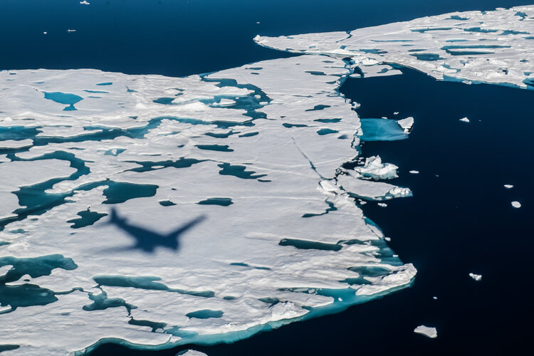
Since it was launched more than 12 years ago, ESA’s CryoSat ice mission has dazzled by way of its sheer technological and scientific excellence. This superb Earth Explorer satellite has returned a wealth of information that has transformed our understanding of Earth’s ice and how it is responding to climate change. In some circumstances, however, being dazzled isn’t a good thing, particularly when it comes to measuring the height of sea ice from space during the summer.
A paper published in Nature describes how scientists have now found an ingenious way of removing the pesky problem of dazzle from surface meltwater to yield the first ever continuous, year-round, altimetry measurements of sea-ice thickness in the Arctic Ocean.
Müllerova mapa Čech, opakování výstavy ke 300 letům výročí
14.9.2022 15:28 ZeměměřičV Národním technickém muzeu byla zahájena výstava „300 let Müllerovy mapy Čech“. Výstavu tentokrát můžete navštívit až do 30. dubna 2023. Výstava, věnovaná významnému kartografickému dílu, které již před 302 lety vytvořil Jan Kryštof Müller, se poprvé konala v roce 2020, kdy slavila 300 let výročí. V té době se však výstava – kvůli pandemickým opatřením – […]
The post Müllerova mapa Čech, opakování výstavy ke 300 letům výročí appeared first on Zeměměřič.
Leading Space Innovators Join Forces to Create World's First Satellite with Both SAR and Optical Payloads to Revolutionize Geospatial Imaging
14.9.2022 15:16 GISCafe.com Webcasts-Webinars LOS ALTOS, Calif. and CHENNAI, India, Sept. 14, 2022 — (PRNewswire) — Antaris, the software platform provider for space, and GalaxEye, …Sanborn Acquires AppGeo; Creates Geospatial Powerhouse
14.9.2022 15:16 GISCafe.com Webcasts-Webinars COLORADO SPRINGS, Colo. — (BUSINESS WIRE) — September 14, 2022 —The Sanborn Map Company, Inc. (Sanborn) a geospatial solution …
REPower EU: A critical moment to make next generation infrastructure digital by design
14.9.2022 13:55 Bentley SystemsPromoting and adopting cutting-edge technologies in infrastructure is crucial to overcome the EU’s current energy crisis and achieve the bloc’s green and digital goals
The post REPower EU: A critical moment to make next generation infrastructure digital by design appeared first on Bentley Systems | Infrastructure Engineering Software Company.Galileo Second Generation technology tested in ESA labs
14.9.2022 13:50 ESA Navigation
Europe’s first generation Galileo constellation is already the world’s most precise satellite navigation system – delivering metre-scale positioning to more than 3.5 billion users worldwide – but Galileo Second Generation will enable still better performance and an expanded range of services. Essential elements of the G2 system are currently being evaluated in ESA laboratories, including key algorithms to synchronise satellite timings and determine orbits as well as test versions of a satnav receiver and emergency beacon.
Včera se konal již 7. ročník konference Aliance Dronedge 2022
14.9.2022 13:44 UAVAVčera se konal již sedmý ročník konference Aliance pro bezpilotní letecký průmysl Dronedge 2022 opět v Praze v kině Dlabačov. Konference měla letos rekordní účast 164 registrovaných návštěvníků, z čehož dorazilo 152 návštěvníků. V předsálí bylo také k vidění spousta novinek od partnerů konference a přednášejících jako například nové drony od švýcarských hostů z WingtraOne […]
The post Včera se konal již 7. ročník konference Aliance Dronedge 2022 appeared first on UAV Aliance pro bezpilotní letecký průmysl.
Methods to specify information requirements in digital construction projects
14.9.2022 12:14 buildingSMART.orgWith the ever-growing digitalisation of the built environment, specifying information requirements (IR) is crucial to control the Building Information Modelling (BIM) data. However, encoding these requirements is subject to a…
The post Methods to specify information requirements in digital construction projects appeared first on buildingSMART International.
Mobilní liniové řízení od VARS: cesta k cestám bez kolon
14.9.2022 2:00 VARS.czPlynulejší provoz v dopravních omezeních, menší riziko nehody a také méně stresu pro řidiče. To je výsledek zavedení automatizovaného mobilního liniového řízení dopravy. ŘSD má nyní k dispozici šest sad, které pomáhají zlepšit dopravu třeba v omezení na příjezdu do Prahy po D11. Jak „mobilní liniovka“ funguje? A co dokáže?
Velký pražský úklid. Systém od VARS zastřeší data o telematice. A dokáže předvídat poruchy
14.9.2022 2:00 VARS.cz
Dostat víc jak 150 tisíc telematických zařízení rozmístěných
po Praze do jednoho „seznamu“. To je cíl projektu Pasportizace telematického
majetku, který nyní realizuje VARS BRNO u pražského správce komunikací TSK
Praha. „Nad samotnou evidencí zařízení tvoříme chytrý systém s principy
umělé inteligence, který bude schopný sledovat životní cyklus jednotlivých
zařízení a řídit plánování revizí, oprav, nebo výměny,“ vysvětluje technický
ředitel VARS BRNO David Novák, v čem je projekt výjimečný.
Nabídka práce - Technický referent pro oblast Galileo GNSS
14.9.2022 0:00 Geografický ústav MUNárodní centrum PRS nabízí práci na pozici Technický referent pro oblast Galileo GNSS.
Bližší informace naleznete na webu https://www.jobs.cz/rpd/1599567996/?searchId=c8485c28-dc47-418b-b139-7f950c421db6&rps=233.
V pátek 16.9.2022 je knihovna uzavřena [Knihovna geografie, byTopic]
14.9.2022 0:00 Katedra aplikované geoinformatiky a kartografie Přf UK Upozorňujeme, že v pátek 16. září 2022 bude knihovna geografie z provozních důvodů (oprava vodovodu v budově Albertov 6) uzavřena!First Airbus Eurostar Neo satellite ready for shipment to launch site
13.9.2022 23:26 GISCafe.com Webcasts-Webinars HOTBIRD 13F to offer EUTELSAT state of the art broadcast capabilityWith its twin HOTBIRD 13G, both satellites will broadcast over 1,000 television …Opakovaná skúška držiteľov osvedčení na projektovanie pozemkových úprav
13.9.2022 16:48 Komora pozemkových úprav SR
Prihlasovanie na termíny a miesta konania opakovanej skúšky
HERE SDK Navigate now available in Japan
13.9.2022 15:41 GISCafe.com Webcasts-Webinars Global businesses and local enterprises in Japan across industries can now enhance their mobile applications with customized maps, truck …Allied Industrial Partners-Backed CES Power Acquires Brickworks
13.9.2022 15:40 GISCafe.com Webcasts-Webinars MEMPHIS, Tenn. and SAN DIEGO, Sept. 13, 2022 — (PRNewswire) — CES Power LLC ("CES Power"), a leading global provider of mobile power …Aeva To Demonstrate 4D LiDAR Technology For Commercial Vehicles At IAA Transportation 2022
13.9.2022 15:40 GISCafe.com Webcasts-Webinars Next-Generation 4D LiDAR Technology Provides Safety-Critical Benefits for Advanced Assisted Driving and Autonomous Commercial VehiclesMOUNTAIN VIEW, …