


![]()

zprávy
zdroje zpráv:Odborný referent – kontrola aktualizace
14.10.2022 11:07 ČÚZK - volná místa Katastrální úřad pro Moravskoslezský kraj Katastrální pracoviště Frýdek-Místek vypisuje výběrové řízení na místo Odborný referent – kontrola aktualizaceOdborný referent – kontrola aktualizace
14.10.2022 11:07 ČÚZK - předpisy a opatření Katastrální úřad pro Moravskoslezský kraj Katastrální pracoviště Frýdek-Místekvypisuje výběrové řízení na místo
Odborný referent – kontrola aktualizace
Odborný referent – kontrola aktualizace
14.10.2022 11:07 ČÚZK /Urady/Katastralni-urady/Katastralni-urady/Katastralni-urad-pro-Moravskoslezsky-kraj/Uredni-deska/Oznameni-a-jina-uredni-sdeleni/Volna-mista/DMS/Odborny-referent-–-kontrola-aktualizaceEarth from Space: Mississippi River
14.10.2022 10:00 ESA Observing the Earth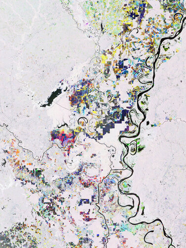
Mississippi River, one of the longest rivers in North America, is featured in this multi-temporal radar image captured by the Copernicus Sentinel-1 mission.
Earth from Space: Mississippi River
14.10.2022 10:00 ESA Observing the Earth
Mississippi River, one of the longest rivers in North America, is featured in this multi-temporal radar image captured by the Copernicus Sentinel-1 mission.
výluka dat schánek
14.10.2022 9:55 ČÚZK /Urady/Katastralni-urady/Katastralni-urady/Katastralni-urad-pro-hlavni-mesto-Prahu/O-uradu/Aktuality/Do-3-11VR do 02.12
14.10.2022 9:55 ČÚZK - předpisy a opatření Katastrální úřad pro hlavní město Prahu - Katastrální pracoviště Praha zveřejnil novou aktualitu: Ředitelka úřadu vyhlašuje výběrové řízení na služební místo:odborný referent/vrchní referent – poskytování informací KN
VR do 02.12
14.10.2022 9:55 ČÚZK /Urady/Katastralni-urady/Katastralni-urady/Katastralni-urad-pro-hlavni-mesto-Prahu/O-uradu/Aktuality/Do-3-11Do 3.11
14.10.2022 9:55 ČÚZK - předpisy a opatření Katastrální úřad pro hlavní město Prahu - Katastrální pracoviště Praha zveřejnil novou aktualitu: Ředitelka úřadu vyhlašuje výběrové řízení na služební místo:* odborný referent/vrchní referent – vedení katastrální mapy
VR do 20.12.2022
14.10.2022 9:55 ČÚZK - předpisy a opatření Katastrální úřad pro hlavní město Prahu - Katastrální pracoviště Praha zveřejnil novou aktualitu: Ředitelka úřadu vyhlašuje výběrové řízení na služební místo:rada/odborný rada – revize katastrálního operátu
Do 3.11
14.10.2022 9:55 ČÚZK - předpisy a opatření Český úřad zeměměřický a katastrální - Katastrální pracoviště Praha zveřejnil novou aktualitu: Ředitelka úřadu vyhlašuje výběrové řízení na služební místo:* odborný referent/vrchní referent – vedení katastrální mapy
VR do 20.12.2022
14.10.2022 9:55 ČÚZK /Urady/Katastralni-urady/Katastralni-urady/Katastralni-urad-pro-hlavni-mesto-Prahu/O-uradu/Aktuality/Do-3-11VR do 20.12.2022
14.10.2022 9:55 ČÚZK - předpisy a opatření Katastrální úřad pro hlavní město Prahu - Katastrální pracoviště Praha zveřejnil novou aktualitu: Ředitelka úřadu vyhlašuje výběrové řízení na služební místo:rada/odborný rada – revize katastrálního operátu
výluka dat schánek
14.10.2022 9:55 ČÚZK - předpisy a opatření Katastrální úřad pro hlavní město Prahu - Katastrální pracoviště Praha zveřejnil novou aktualitu: Ministerstvo vnitra ČR infomovalo o výluce informačního systému datových schránekod 31. prosince 2022, 0:00 hodin do 2. ledna 2023, 23:59 hodin
více
Do 3.11
14.10.2022 9:55 ČÚZK /Urady/Katastralni-urady/Katastralni-urady/Katastralni-urad-pro-hlavni-mesto-Prahu/O-uradu/Aktuality/Do-3-11odborný referent/vrchní referent – vedení katastrální mapy
14.10.2022 9:52 ČÚZK - předpisy a opatření Katastrální úřad pro hlavní město Prahu - Katastrální pracoviště Prahavypisuje výběrové řízení na místo
odborný referent/vrchní referent – vedení katastrální mapy
odborný referent/vrchní referent – vedení katastrální mapy
14.10.2022 9:52 ČÚZK - volná místa Katastrální úřad pro hlavní město Prahu - Katastrální pracoviště Praha vypisuje výběrové řízení na místo odborný referent/vrchní referent – vedení katastrální mapyPaul King on digital building tech and where it’s taking us
13.10.2022 21:30 Bentley SystemsPublication October 13, 2022 | Press Coverage Read Article
The post Paul King on digital building tech and where it’s taking us appeared first on Bentley Systems | Infrastructure Engineering Software Company.Hyundai Tucson
13.10.2022 10:12 ČÚZK - předpisy a opatřeníKatastrální úřad pro Moravskoslezský kraj nabízí nepotřebný majetek k odkupu. Jedná se o
Hyundai Tucson
Hyundai Tucson
13.10.2022 10:12 ČÚZK /Urady/Katastralni-urady/Katastralni-urady/Katastralni-urad-pro-Moravskoslezsky-kraj/Nabidky-majetku/Hyundai-Tucson
Portál ESKN - prevádzková informácia
13.10.2022 9:35
ÚGKK SR
Vážení používatelia,
dovoľujeme si Vás informovať, že v piatok 14.októbra 2022 od 16:00 hod. môže vo výnimočných prípadoch dochádzať k výpadkom dostupnosti služieb portálu elektronických služieb katastra nehnuteľností z dôvodu prebiehajúcich technických prác na ÚPVS (Ústrednom portáli verejnej správy).
Za spôsobené obmedzenie sa ospravedlňujeme a ďakujeme za pochopenie.
#PortálESKN #od:14.10.2022@16:00 #do: 14.10.2022@24:00
20221013_Rada / odborný rada oddělení právních vztahů k nemovitostem
13.10.2022 9:18 ČÚZK /Urady/Katastralni-urady/Katastralni-urady/Katastralni-urad-pro-Stredocesky-kraj/Katastralni-pracoviste/KP-Pribram/O-uradu/Aktuality/20210922_Odborny-referent-oddeleni-aktualizace-(1)20221013_Rada / odborný rada oddělení právních vztahů k nemovitostem
13.10.2022 9:18 ČÚZK - předpisy a opatření Katastrální úřad pro Středočeský kraj - Katastrální pracoviště Příbram Vyhlášení výběrového řízení: Rada / odborný rada oddělení právních vztahů k nemovitostem V části "Úřední deska", v sekci "Oznámení a jiná úřední sdělení" bylo vystaveno "Oznámení o vyhlášení výběrového řízení na obsazení služebního místa Rada / odborný rada oddělení právních vztahů k nemovitostem"The Cost-Saving Benefits of Digital Twin: Bentley’s Cecilia Correia joins WF&M Conversations
12.10.2022 21:15 Bentley SystemsPublication October 12, 2022 | Press Coverage Read Article
The post The Cost-Saving Benefits of Digital Twin: Bentley’s Cecilia Correia joins WF&M Conversations appeared first on Bentley Systems | Infrastructure Engineering Software Company.20221012 - změny vyvolané zrušením okresu Praha
12.10.2022 17:03 ČÚZK /ruian/Novinky-RUIAN/Archiv-novinek-RUIAN/2022/20221012-zmeny-vyvolane-zrusenim-okresu-Praha20221012 - změny vyvolané zrušením okresu Praha
12.10.2022 16:57 ČÚZK /ruian/Poskytovani-udaju-ISUI-RUIAN-VDP/Vymenny-format-RUIAN-(VFR)/Archiv-novinek-VFR/2022/20221012-zmeny-vyvolane-zrusenim-okresu-Praha20221012_Vedoucí oddělení aktualizace PI KN II. – rada / odborný rada
12.10.2022 13:21 ČÚZK - předpisy a opatření Katastrální úřad pro Středočeský kraj - Katastrální pracoviště Praha-východ Vyhlášení výběrového řízení: Vedoucí oddělení aktualizace PI KN II. – rada / odborný rada V části "Úřední deska", v sekci "Oznámení a jiná úřední sdělení" bylo vystaveno "Oznámení o vyhlášení výběrového řízení na obsazení služebního místa Vedoucí oddělení aktualizace PI KN II. – rada / odborný rada"20221012_Vedoucí oddělení aktualizace PI KN II. – rada / odborný rada
12.10.2022 13:21 ČÚZK /Urady/Katastralni-urady/Katastralni-urady/Katastralni-urad-pro-Stredocesky-kraj/Katastralni-pracoviste/KP-Praha-vychod/O-uradu/Aktuality/20210922_Odborny-referent-oddeleni-aktualizace-(1)Vedoucí oddělení aktualizace PI KN II. – rada / odborný rada
12.10.2022 13:21 ČÚZK - volná místa Katastrální úřad pro Středočeský kraj Katastrální pracoviště Praha-východ vypisuje výběrové řízení na místo Vedoucí oddělení aktualizace PI KN II. – rada / odborný radaVedoucí oddělení aktualizace PI KN II. – rada / odborný rada
12.10.2022 13:21 ČÚZK /Urady/Katastralni-urady/Katastralni-urady/Katastralni-urad-pro-Stredocesky-kraj/Uredni-deska/Oznameni-a-jina-uredni-sdeleni/Volna-mista/DMS/Vedouci-oddeleni-aktualizace-PI-KN-II-–-rada-odVedoucí oddělení aktualizace PI KN II. – rada / odborný rada
12.10.2022 13:21 ČÚZK - předpisy a opatření Katastrální úřad pro Středočeský kraj Katastrální pracoviště Praha-východvypisuje výběrové řízení na místo
Vedoucí oddělení aktualizace PI KN II. – rada / odborný rada
Seasonal changes in Antarctic ice sheet flow dynamics detected for the first time
12.10.2022 11:00 ESA Observing the Earth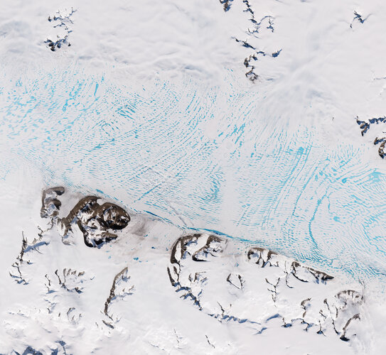
Certain estimates of Antarctica’s total contribution to sea-level rise may be over, or even underestimated, after researchers detected a previously unknown source of ice loss variability. In a new paper published in The Cryosphere, researchers using Copernicus Sentinel-1 data, found that glaciers feeding the George VI Ice Shelf speed up by approximately 15% during the Antarctic summer. This is the first time that such seasonal cycles have been detected on land ice flowing into ice shelves in Antarctica.
Navigation at Ministerial Council 2022
12.10.2022 10:56 ESA Navigation
The ESA Council at Ministerial level, CM22, is a time for critical decisions. In November 2022, ESA’s Member States, Associate States and Cooperating States will come together to strengthen Europe’s space sector and ensure it continues to serve European citizens.
rada / odborný rada v oddělení metodiky a kontroly na Katastrálním úřadu pro Liberecký kraj
12.10.2022 10:39 ČÚZK - předpisy a opatření Katastrální úřad pro Liberecký krajvypisuje výběrové řízení na místo
rada / odborný rada v oddělení metodiky a kontroly na Katastrálním úřadu pro Liberecký kraj
rada / odborný rada v oddělení metodiky a kontroly na Katastrálním úřadu pro Liberecký kraj
12.10.2022 10:39 ČÚZK /Urady/Katastralni-urady/Katastralni-urady/Katastralni-urad-pro-Liberecky-kraj/Uredni-deska/Oznameni-a-jina-uredni-sdeleni/Volna-mista/DMS/rada-odborny-rada-v-oddeleni-metodiky-a-kontrolyrada / odborný rada v oddělení metodiky a kontroly na Katastrálním úřadu pro Liberecký kraj
12.10.2022 10:39 ČÚZK - volná místa Katastrální úřad pro Liberecký kraj vypisuje výběrové řízení na místo rada / odborný rada v oddělení metodiky a kontroly na Katastrálním úřadu pro Liberecký kraj12102022-Statistické údaje 3. čtvrtletí
12.10.2022 10:22 ČÚZK - předpisy a opatření Český úřad zeměměřický a katastrální zveřejnil novou aktualitu: Zveřejněny statistické údaje za 3. čtvrtletí roku 2022 o vybraných transakcích s nemovitostmi evidovanými v KN.12102022-Statistické údaje 3. čtvrtletí
12.10.2022 10:22 ČÚZK /Aktuality-resort/2022/12102022-Statisticke-udaje-3-ctvrtleti12102022-Statistické údaje 3. čtvrtletí
12.10.2022 10:22 ČÚZK - aktuality v resortu Zveřejněny statistické údaje za 3. čtvrtletí roku 2022 o vybraných transakcích s nemovitostmi evidovanými v KN.rada / odborný rada v oddělení právních vztahů k nemovitostem na Katastrálním pracovišti Liberec Kat
12.10.2022 10:14 ČÚZK - předpisy a opatření Katastrální úřad pro Liberecký kraj - Katastrální pracoviště Liberecvypisuje výběrové řízení na místo
rada / odborný rada v oddělení právních vztahů k nemovitostem na Katastrálním pracovišti Liberec Katastrálního úřadu pro Liberecký kraj
rada / odborný rada v oddělení právních vztahů k nemovitostem na Katastrálním pracovišti Liberec Kat
12.10.2022 10:14 ČÚZK /Urady/Katastralni-urady/Katastralni-urady/Katastralni-urad-pro-Liberecky-kraj/Uredni-deska/Oznameni-a-jina-uredni-sdeleni/Volna-mista/DMS/rada-odborny-rada-v-oddeleni-pravnich-vztahu-k-nrada / odborný rada v oddělení právních vztahů k nemovitostem na Katastrálním pracovišti Liberec Kat
12.10.2022 10:14 ČÚZK - volná místa Katastrální úřad pro Liberecký kraj - Katastrální pracoviště Liberec vypisuje výběrové řízení na místo rada / odborný rada v oddělení právních vztahů k nemovitostem na Katastrálním pracovišti Liberec Katrada / odborný rada v oddělení právních vztahů k nemovitostem na Katastrálním pracovišti Liberec Kat
12.10.2022 10:04 ČÚZK - volná místa Katastrální úřad pro Liberecký kraj - Katastrální pracoviště Liberec vypisuje výběrové řízení na místo rada / odborný rada v oddělení právních vztahů k nemovitostem na Katastrálním pracovišti Liberec Katrada / odborný rada v oddělení právních vztahů k nemovitostem na Katastrálním pracovišti Liberec Kat
12.10.2022 10:04 ČÚZK - předpisy a opatření Katastrální úřad pro Liberecký kraj - Katastrální pracoviště Liberecvypisuje výběrové řízení na místo
rada / odborný rada v oddělení právních vztahů k nemovitostem na Katastrálním pracovišti Liberec Katastrálního úřadu pro Liberecký kraj
rada / odborný rada v oddělení právních vztahů k nemovitostem na Katastrálním pracovišti Liberec Kat
12.10.2022 10:04 ČÚZK /Urady/Katastralni-urady/Katastralni-urady/Katastralni-urad-pro-Liberecky-kraj/Uredni-deska/Oznameni-a-jina-uredni-sdeleni/Volna-mista/DMS/misto-rada-odborny-rada-v-oddeleni-pravnich-vztvrchní referent / rada v oddělení právních vztahů k nemovitostem na Katastrálním pracovišti Libere
12.10.2022 9:54 ČÚZK /Urady/Katastralni-urady/Katastralni-urady/Katastralni-urad-pro-Liberecky-kraj/Uredni-deska/Oznameni-a-jina-uredni-sdeleni/Volna-mista/DMS/vrchni-referent-rada-v-oddeleni-pravnich-vztahuvrchní referent / rada v oddělení právních vztahů k nemovitostem na Katastrálním pracovišti Libere
12.10.2022 9:54 ČÚZK - volná místa Katastrální úřad pro Liberecký kraj vypisuje výběrové řízení na místo vrchní referent / rada v oddělení právních vztahů k nemovitostem na Katastrálním pracovišti Liberevrchní referent / rada v oddělení právních vztahů k nemovitostem na Katastrálním pracovišti Libere
12.10.2022 9:54 ČÚZK - předpisy a opatření Katastrální úřad pro Liberecký kraj - Katastrální pracoviště Liberecvypisuje výběrové řízení na místo
vrchní referent / rada v oddělení právních vztahů k nemovitostem na Katastrálním pracovišti Liberec Katastrálního úřadu pro Liberecký kraj
vrchní referent / rada v oddělení právních vztahů k nemovitostem na Katastrálním pracovišti Libere
12.10.2022 9:54 ČÚZK - volná místa Katastrální úřad pro Liberecký kraj - Katastrální pracoviště Liberec vypisuje výběrové řízení na místo vrchní referent / rada v oddělení právních vztahů k nemovitostem na Katastrálním pracovišti LibereUAVA Aliance uvedena v Drone Market Environment mezi největšími světovými koalicemi a organizacemi pro drony
12.10.2022 9:36 UAVATento týden byla zveřejněna infografika světového Drone Market Environment pro letošní rok 2022 od DRONEII.com – Drone Industry Insights, kde nechybí Aliance pro bezpilotní letecký průmysl UAVA mezi Coalitions and Organizations. Mezi dalšími českými zástupci je například UpVision, Workswell a Primocco. Skvělý úspěch pro Alianci a Českou republiku…
The post UAVA Aliance uvedena v Drone Market Environment mezi největšími světovými koalicemi a organizacemi pro drony appeared first on UAV Aliance pro bezpilotní letecký průmysl.
Will megaprojects bring Australia’s construction industry to the next level?
12.10.2022 8:35 Bentley SystemsAustralia’s era of megaprojects has begun
The post Will megaprojects bring Australia’s construction industry to the next level? appeared first on Bentley Systems | Infrastructure Engineering Software Company.Krátka správa č. 45/2022
11.10.2022 15:27 Komora geodetů a kartografů SRThe post Krátka správa č. 45/2022 appeared first on Komora geodetov a kartografov.
20221011_Odborný referent oddělení aktualizace GI KN
11.10.2022 14:15 ČÚZK - předpisy a opatření Katastrální úřad pro Středočeský kraj - Katastrální pracoviště Praha-východ Vyhlášení výběrového řízení: Odborný referent oddělení aktualizace GI KN V části "Úřední deska", v sekci "Oznámení a jiná úřední sdělení" bylo vystaveno "Oznámení o vyhlášení výběrového řízení na obsazení služebního místa Odborný referent oddělení aktualizace GI KN"20221011_Odborný referent oddělení aktualizace GI KN
11.10.2022 14:15 ČÚZK /Urady/Katastralni-urady/Katastralni-urady/Katastralni-urad-pro-Stredocesky-kraj/Katastralni-pracoviste/KP-Praha-vychod/O-uradu/Aktuality/20210922_Odborny-referent-oddeleni-aktualizace-(7)Odborný referent oddělení aktualizace GI KN
11.10.2022 14:14 ČÚZK - předpisy a opatření Katastrální úřad pro Středočeský kraj Katastrální pracoviště Praha-východvypisuje výběrové řízení na místo
Odborný referent oddělení aktualizace GI KN
Odborný referent oddělení aktualizace GI KN
11.10.2022 14:14 ČÚZK - volná místa Katastrální úřad pro Středočeský kraj Katastrální pracoviště Praha-východ vypisuje výběrové řízení na místo Odborný referent oddělení aktualizace GI KNKrásy planety Země z vesmíru (pozvánka)
11.10.2022 13:15 GISportal.cz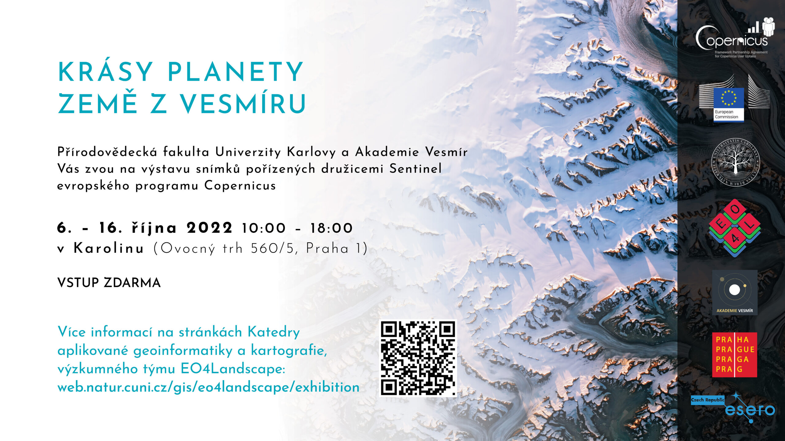
Katedra aplikované geoinformatiky a kartografie, PřF UK vás srdečně zve na výstavu „Krásy planety Země z vesmíru „, která se koná v Praze v Karolinu do 16. října, otevřeno 10:00 – 18:00. Výstava prezentuje umělecky zpracované družicové snímky pořízené družicemi Sentinel z evropského programu Copernicus a originálním způsobem odhaluje nebývalé výzkumné možnosti družicového průzkumu Země.
The post Krásy planety Země z vesmíru (pozvánka) appeared first on GISportal.cz.
Krásy planety Země z vesmíru (pozvánka)
11.10.2022 13:15 GISportal.czKatedra aplikované geoinformatiky a kartografie, PřF UK vás srdečně zve na výstavu „Krásy planety Země z vesmíru „, která se koná v Praze v Karolinu do 16. října, otevřeno 10:00 – 18:00. Výstava prezentuje umělecky zpracované družicové snímky pořízené družicemi Sentinel z evropského programu Copernicus a originálním způsobem odhaluje nebývalé výzkumné možnosti družicového průzkumu Země.
The post Krásy planety Země z vesmíru (pozvánka) appeared first on GISportal.cz.
GIS v plánování měst a regionů 2022 (aktualizace)
11.10.2022 12:51 GISportal.cz
Na letošní konferenci GIS v plánování měst a regionů jsme Vás již zvali, nyní máme i aktuální program, na který organizátoři lákají.
The post GIS v plánování měst a regionů 2022 (aktualizace) appeared first on GISportal.cz.
New RTK with Dual-Camera & Handheld SLAM Scanner Arrive
11.10.2022 12:11 Satlab GeosolutionsDate: 12 October 2022 What would happen when image survey and AR live-view stakeout […]
The post New RTK with Dual-Camera & Handheld SLAM Scanner Arrive appeared first on Global Satellite Positioning Solutions | SatLab Geosolutions AB.
New RTK with Dual-Camera & Handheld SLAM Scanner Arrive
11.10.2022 12:11 Satlab Geosolutions Date: 12 October 2022 What would happen when image survey and AR live-view stakeout […]Novinky v aplikacích
11.10.2022 11:00 ČÚZK - Geoportál Novinky v aplikacíchGeoprohlížeč:
Ve widgetu Přidat vrstvy, v záložce REST, je možné přidávat celá externí REST rozhraní a přidávat z nich vybrané služby přímo do Geoprohlížeče.
V Rozšířeném vyhledávání katastrálních území je nyní možné řadit více výsledků za sebou a použít je jako součást výstupu pro Tisk.
Na mobilních zařízeních jsou v horní liště dostupné nejdůležitější widgety a není nutné je hledat v Menu.
Archiv:
Do archivu LMS byly přidány nově naskenované snímky z let 1971 a 2022.
V Archivních mapách jsou nově dostupné Generální mapy 3. vojenského mapování.
Jména světa:
Ve 3D prostředí (menu "Doplňky") jsou na mapách Měsíce a Marsu dostupná jména. Pro Mars zatím pouze ukázka, na Měsíci je kompletní popis na přivrácené straně.
Novinky v aplikacích
11.10.2022 10:00 ČÚZK - Geoportál Novinky v aplikacíchGeoprohlížeč:
Ve widgetu Přidat vrstvy, v záložce REST, je možné přidávat celá externí REST rozhraní a přidávat z nich vybrané služby přímo do Geoprohlížeče.
V Rozšířeném vyhledávání katastrálních území je nyní možné řadit více výsledků za sebou a použít je jako součást výstupu pro Tisk.
Na mobilních zařízeních jsou v horní liště dostupné nejdůležitější widgety a není nutné je hledat v Menu.
Archiv:
Do archivu LMS byly přidány nově naskenované snímky z let 1971 a 2022.
V Archivních mapách jsou nově dostupné Generální mapy 3. vojenského mapování.
Jména světa:
Ve 3D prostředí (menu "Doplňky") jsou na mapách Měsíce a Marsu dostupná jména. Pro Mars zatím pouze ukázka, na Měsíci je kompletní popis na přivrácené straně.
Nové číslo GaKO
11.10.2022 9:00
ÚGKK SR
Nové číslo časopisu Geodetického a Kartografického Obzoru 10/2022
GaKO 10/2022
11.10.2022 7:43 GaKO GaKO 10/2022 KOREKÁČOVÁ, B.–JANÁK, J.: Variácie ľadovcovej pokrývky kontinentálneho ľadovca Austfonna určené na základe globálnych modelov tiažového poľa Země HÁNEK, P.–HÁNEK, P. ml.: Georg Friedrich von Reichenbach a jeho dobaGaKO 10/2022
11.10.2022 7:43 GaKO GaKO 10/2022 KOREKÁČOVÁ, B.–JANÁK, J.: Variácie ľadovcovej pokrývky kontinentálneho ľadovca Austfonna určené na základe globálnych modelov tiažového poľa Země HÁNEK, P.–HÁNEK, P. ml.: Georg Friedrich von Reichenbach a jeho dobaOdstávka pracoviště
11.10.2022 7:29 ČÚZK /Urady/Katastralni-urady/Katastralni-urady/Katastralni-urad-pro-Plzensky-kraj/O-uradu/Aktuality/Odstavka-pracovisteOdstávka pracoviště
11.10.2022 7:29 ČÚZK - předpisy a opatření Katastrální úřad pro Plzeňský kraj - Katastrální pracoviště Kralovice zveřejnil novou aktualitu: Katastrální pracoviště Kralovice bude dne 27.10.2022 z provozních důvodů uzavřeno (odstávka elektrické energie).Knihovnu geografie navštívili studenti z Finska [Knihovna geografie, byTopic]
11.10.2022 0:00 Katedra aplikované geoinformatiky a kartografie Přf UK Skupina 13 studentů geografie a biologie pod vedením Jenny Nyman z Přírodovědecké fakulty Univerzity v Turku dnes navštívila Knihovnu geografie a Mapovou sbírku. Akci organizuje jejich univerzitní studentský klub. V Česku pobývají tento týden (10.–15.10.2022). Zajímají se díky své kombinaci o systém ochrany přírody v ČR ve vztahu ke geografii a turismu, v dalších dnech proto hodlají navštívit mj. NP České Švýcarsko.DTM ČR Viewer od firmy Geovap
10.10.2022 20:51 ZeměměřičPardubická firma Geovap, producent softwarů pro geodety a geomatiky, uvedla na trh DTM ČR Viewer pro data projektu Digitální technické mapy ČR. Ten doplňuje řadu programů GeoStore V6 pro práci v geodézii a katastru, inženýrské geodézii, 3D. Software nazvaný DTM ČR Viewer umožňuje prohlížení dat DTM ve 3D, načítání výměnného formátu JVF DTM a kontroly dat DTM nad webovými […]
The post DTM ČR Viewer od firmy Geovap appeared first on Zeměměřič.
Uzavření pracoviště
10.10.2022 18:34 ČÚZK /Urady/Katastralni-urady/Katastralni-urady/Katastralni-urad-pro-Plzensky-kraj/Katastralni-pracoviste/KP-Kralovice/O-uradu/Aktuality/Uzavreni-pracovisteUzavření pracoviště
10.10.2022 18:34 ČÚZK - předpisy a opatření Katastrální úřad pro Plzeňský kraj - Katastrální pracoviště Kralovicezveřejnil novou aktualitu: Katastrální pracoviště Kralovice oznamuje, že dne 27. 10. 2022 bude z provozních důvodů uzavřeno (odstávka dodávky elektrické energie).
Uzavření pracoviště
10.10.2022 18:34 ČÚZK - předpisy a opatření Katastrální úřad pro Plzeňský kraj - Katastrální pracoviště Kralovicezveřejnil novou aktualitu: Katastrální pracoviště Kralovice bude dne 27.10.2022 z provozních důvodů uzavřeno (odstávka elektrické energie).
Krátka správa č. 442022
10.10.2022 16:01 Komora geodetů a kartografů SRThe post Krátka správa č. 442022 appeared first on Komora geodetov a kartografov.
Krátka správa č. 44/2022
10.10.2022 16:01 Komora geodetů a kartografů SRThe post Krátka správa č. 44/2022 appeared first on Komora geodetov a kartografov.
Italy’s Stromboli erupts
10.10.2022 16:00 ESA Observing the Earth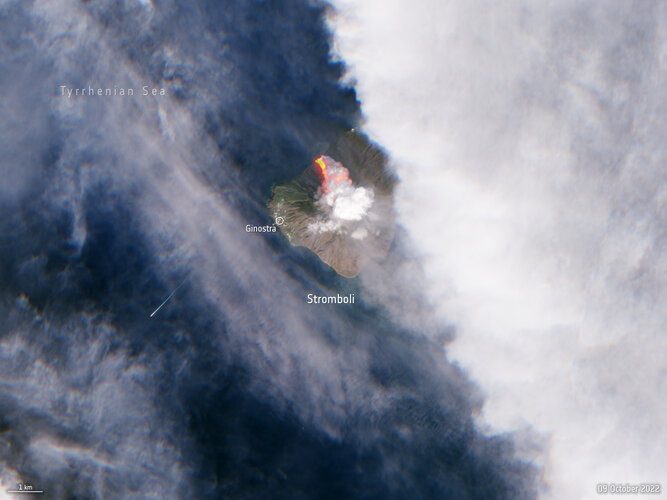 Image:
A volcano on the Italian island of Stromboli erupted early on Sunday morning, releasing huge plumes of smoke and a lava flow pouring into the sea. The Copernicus Sentinel-2 mission captured this image of the aftermath less than five hours after the eruption.
Image:
A volcano on the Italian island of Stromboli erupted early on Sunday morning, releasing huge plumes of smoke and a lava flow pouring into the sea. The Copernicus Sentinel-2 mission captured this image of the aftermath less than five hours after the eruption.
Krátka správa č. 43/2022
10.10.2022 15:59 Komora geodetů a kartografů SRThe post Krátka správa č. 43/2022 appeared first on Komora geodetov a kartografov.
Digitální technická mapa ČR
10.10.2022 15:31 GEPROV souvislosti s digitální technickou mapou ČR (DTM ČR), Vás chceme ujistit, že: Verze 16 našich systémů (MISYS, KOKEŠ, PROLAND, Geoportál GEPRO) jsou plně připraveny k práci s daty DTM ČR a jejich plnému využití. Systémy MISYS, KOKEŠ i PROLAND umožňují data do digitální technické mapy krajů pomocí jednotného výměnného formátu (JVF DTM) předávat a …
Digitální technická mapa ČR Pokračovat ve čtení »
Článek Digitální technická mapa ČR se nejdříve objevil na GEPRO.
TRUTHS on the table at ESA’s Ministerial Council
10.10.2022 14:45 ESA Observing the Earth
With the satellite and instrument design consolidated and the scientific community assured it will deliver the data they need, TRUTHS has been approved as part of Earth Observation Programme proposal for the upcoming ESA Council Meeting at Ministerial Level. Carrying a primary International System of Units reference system, TRUTHS promises to set the gold standard for climate measurements.
Citic Heavy Industries Uses Collaborative BIM Technology to Deliver Green, Smart Cement Factory
10.10.2022 14:05 Bentley SystemsCitic Heavy Industries Uses Collaborative BIM Technology to Deliver Green, Smart Cement Factory
The post Citic Heavy Industries Uses Collaborative BIM Technology to Deliver Green, Smart Cement Factory appeared first on Bentley Systems | Infrastructure Engineering Software Company.Citic Heavy Industries Uses Collaborative BIM Technology to Deliver Green, Smart Cement Factory
10.10.2022 14:05 Bentley SystemsTechInvestOctober 10, 2022 | Press Coverage Read More
The post Citic Heavy Industries Uses Collaborative BIM Technology to Deliver Green, Smart Cement Factory appeared first on Bentley Systems | Infrastructure Engineering Software Company.Citic Heavy Industries Uses Collaborative BIM Technology to Deliver Green, Smart Cement Factory
10.10.2022 14:05 Bentley SystemsTechInvest October 10, 2022 | Press Coverage Read More
The post Citic Heavy Industries Uses Collaborative BIM Technology to Deliver Green, Smart Cement Factory appeared first on Bentley Systems | Infrastructure Engineering Software Company.Earth observation inspires global inventiveness
10.10.2022 11:35 ESA Observing the Earth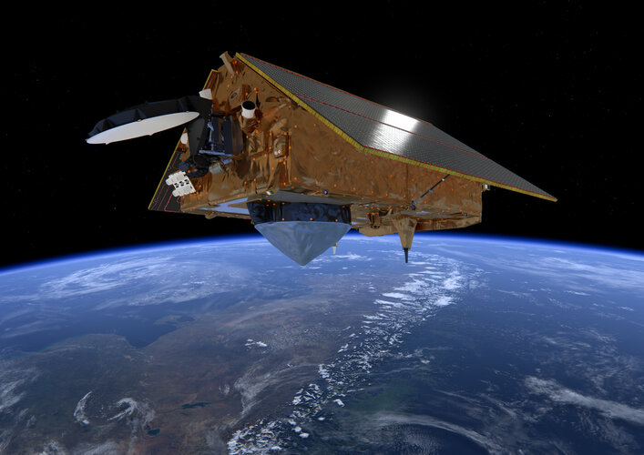
Today our home planet Earth is being more closely monitored than at any time in its history. Some 1 460 Earth-observing satellites have been launched during the last two decades, with Europe’s Copernicus Sentinel fleet in the forefront of environmental data gathering. A new report led by the European Patent Office examining associated patent filings reveals a 1 800% increase in the same period – with European activity comparatively stagnant compared to international competitors.
20221010 - uzavření pracovistě KP Žatec 25.10.2022
10.10.2022 11:03 ČÚZK - předpisy a opatření Katastrální úřad pro Ústecký kraj - Katastrální pracoviště Žatec zveřejnil novou aktualitu: V úterý 25.10.2022 bude technických důvodů uzavřeno katastrální pracoviště v Žatci.Neodkladná podání můžete učinit na ostatních pracovištích KÚ pro Ústecký kraj.
20221010 - uzavření pracovistě KP Žatec 25.10.2022
10.10.2022 11:03 ČÚZK - předpisy a opatření Katastrální úřad pro Ústecký kraj - Katastrální pracoviště Žatec zveřejnil novou aktualitu: V úterý 25.10.2022 bude z technických důvodů uzavřeno katastrální pracoviště v Žatci.Neodkladná podání můžete učinit na ostatních pracovištích KÚ pro Ústecký kraj.
20221010 - uzavření pracovistě KP Žatec 25.10.2022
10.10.2022 11:03 ČÚZK /Urady/Katastralni-urady/Katastralni-urady/Katastralni-urad-pro-Ustecky-kraj/Katastralni-pracoviste/KP-Zatec/O-uradu/Aktuality/20221010-uzavreni-pracoviste-KP-Zatec-25-10-202220221010 - uzavření pracovistě KP Žatec 25.10.2022
10.10.2022 11:03 ČÚZK /Urady/Katastralni-urady/Katastralni-urady/Katastralni-urad-pro-Ustecky-kraj/O-uradu/Aktuality/20221010-uzavreni-pracoviste-KP-Zatec-25-10-202220221010 - uzavření pracovistě KP Žatec 25.10.2022
10.10.2022 11:03 ČÚZK - předpisy a opatření Katastrální úřad pro Ústecký kraj - Katastrální pracoviště Žatec zveřejnil novou aktualitu: V úterý 25.10.2022 bude z technických důvodů uzavřeno katastrální pracoviště v Žatci.Neodkladná podání můžete učinit na ostatních pracovištích KÚ pro Ústecký kraj.
20221010 - uzavření pracovistě KP Žatec 25.10.2022
10.10.2022 11:03 ČÚZK - předpisy a opatření Katastrální úřad pro Ústecký kraj - Katastrální pracoviště Žatec zveřejnil novou aktualitu: V úterý 25.10.2022 bude technických důvodů uzavřeno katastrální pracoviště v Žatci.Neodkladná podání můžete učinit na ostatních pracovištích KÚ pro Ústecký kraj.
výběrové řízení na KP Žďár nad Sázavou
10.10.2022 10:17 ČÚZK - předpisy a opatření Katastrální úřad pro Vysočinu - Katastrální pracoviště Žďár nad Sázavou zveřejnil novou aktualitu: Oznámení o vyhlášení výběrového řízení na služební místo rada/odborný rada v oddělení aktualizace KN Katastrálního pracoviště Žďár nad Sázavou na Katastrálním úřadu pro Vysočinu.rada-odborný rada-aktualizace KN-KP Žďár nad Sázavou
10.10.2022 9:39 ČÚZK /Urady/Katastralni-urady/Katastralni-urady/Katastralni-urad-pro-Vysocinu/Uredni-deska/Oznameni-a-jina-uredni-sdeleni/Volna-mista/DMS/rada-odborny-rada-aktualizace-KN-KP-Zdar-nad-Sazavrada-odborný rada-aktualizace KN-KP Žďár nad Sázavou
10.10.2022 9:39 ČÚZK - volná místa Katastrální úřad pro Vysočinu Katastrální pracoviště Žďár nad Sázavou vypisuje výběrové řízení na místo rada-odborný rada-aktualizace KN-KP Žďár nad Sázavourada-odborný rada-aktualizace KN-KP Žďár nad Sázavou
10.10.2022 9:39 ČÚZK - předpisy a opatření Katastrální úřad pro Vysočinu Katastrální pracoviště Žďár nad Sázavouvypisuje výběrové řízení na místo
rada-odborný rada-aktualizace KN-KP Žďár nad Sázavou